arbn: 80 107 051 749 for personal use only · 11/6/2017 · resources”) (asx code: pgm) on 5...
TRANSCRIPT

1 | P a g e
Artemis Resources Limited ARBN: 80 107 051 749 Level 3, IBM Building, 1060 Hay Street, West Perth, WA Australia, 6006 PO Box R933 Royal Exchange NSW Australia, 1225 Phone: +61 2 9078 7670 Facsimile: +61 2 9078 7661 Email: [email protected] Website: artemisresources.com.au
Directors: Executive Chairman: David Lenigas Executive Directors: Ed Mead Alex Duncan-Kemp Non-Executive Director: Sheikh Maktoum Hasher al Maktoum
Company Secretary: Guy Robertson
Corporate Information ASX Code: ARV
ASX / Media Announcement 6 November 2017
Fortescue Sediments above Munni Munni PGE Deposit
-Karratha, Western Australia-
• Significant Fortescue Group sediments identified overlying Munni Munni PGE deposit.
• 20km south-west of Purdy’s Reward and along trend.
• Munni Munni has approved Mining and Exploration Licences.
• Heritage agreements, Heritage surveys and POWs are already in place.
• 2,218m of previously drilled Fortescue sediments identified in diamond core which has been stored at Munni Munni.
• 12,437m of RC drilling through the Fortescue sediments to be evaluated.
• 70:30 JV between Artemis and Platina Resources Limited (ASX:PGM)
David Lenigas, Artemis’s Executive Chairman, commented;
“It is extraordinary that we have found so much Fortescue sediments overlying our Munni Munni PGE deposit, Australia’s largest Platinum Group Element resource. We now have nearly 15,000 metres of diamond drill core and RC drilling to work our way through to determine the gold potential in these Fortescue sediments. It’s these Fortescue Group rocks that we believe is the host of the gold at our nearby Purdy’s Reward conglomerate gold discovery. Munni Munni has the added advantage of not only having fully approved Mining and Exploration Licences, but it also has all of its Heritage agreements in place which is a big bonus in actually being able to do meaningful work in the Pilbara. This work also raising the possibility of conglomerate gold targets on our Whundo Mining Leases.”
Artemis Resources Limited (“Artemis” or “the Company”) (ASX: ARV) is pleased to announce it has identified significant Fortescue Group sediments over 16km of prospective contact with the Mt Roe Basalts, overlying Artemis’s Munni Munni Platinum Group Element (“PGE”) deposit. Munni Munni (Figures 1,2,3,4) is the largest PGE resource in Australia and is located south of Karratha in the Western Pilbara and the possibility of gold bearing sediments above the platinum/palladium deposit has never been previously considered.
The Company has now determined that significant Fortescue Group sediments sit over major portions of the Munni Munni intrusive complex (MMIC) that hosts the Munni Munni PGE resource. The MMIC is the largest intrusion in the West Pilbara and hosts a JORC 2004 compliant Resource of:1 24 Mt @ 2.9 g/t Platinum Group Element (PGE) + gold (1.4Mt Inferred, 9.8Mt indicated and 12.4Mt Measured) (0.83Moz platinum. 1.14Moz palladium, 152Koz gold and 76Koz rhodium).
1 ASX announcement dated 5 August 2015 “Artemis to earn majority interest in Australia’s largest Platinum
project.” In accordance with Listing Rule 5.23.2, Artemis confirms that it is not aware of any new
information or data that materially affects the information included in the relevant market announcement
¹ referred to above, and that in the case of mineral resources that all material assumptions and technical
parameters underpinning the estimates in the announcement referred to continue to apply and have not
materially changed.
For
per
sona
l use
onl
y

2 | P a g e
This revelation is significant, as the Fortescue Group sediments are considered to be the host to the gold bearing conglomerates currently being explored at Purdy’s Reward, which is located along trend and only 20km to the north-east of Munni Munni.
Figure 1: Showing the close proximity of Purdy’s Reward, Munni Munni, Whundo and the Radio Hill Treatment Facility.
The Company has already identified a total of 2,218m of previously drilled Fortescue Group sediments in diamond core stored at Munni Munni, that is currently in the process of being relocated to Artemis’s nearby Radio Hill operations base.
Accelerated exploration at Munni Munni is entirely possible as the project has the considerable advantage of sitting within 33.5 km2 of approved Mining Leases and 42.5 km2 of approved Exploration Licences, all with heritage agreements in place, approved heritage surveys in place and approved Programme of Works in place with the Department of Mines Industry Regulation and Safety (DMIRS).
There has previously been a grand total of over 85,000m of drilling done (diamond core and RC) at Munni Munni, and the Company has commenced a complete review of the extensive diamond core and RC drill chips that are available on site at the Munni Munni core yard.
Artemis has already identified at least 7 diamond drillholes which were cored from near surface though the Fortescue sequence to the Munni Munni Intrusive Complex. The material intersected in the holes was previously logged simply a Fortescue Group sediments and very little historic work was done on assessing its gold potential.
A substantial amount of data should also be retrievable from reverse circulation (RC) chip trays. The Company has identified that approximately 12,437m of RC drilling has been drilled through the Fortescue sequence.
The Company has started to re-map and sample the prospective unconformity contact zone between the Fortescue/Mt Roe Basalt and the underlying Pilbara Supergroup basement.
For
per
sona
l use
onl
y

3 | P a g e
Tenure of the Munni Munni Project: The Munni Munni Project consists of 4 granted Mining Licences M47/123-126 for 33.5 km2 and 1 granted Exploration Licence E47/3322 of 42.5 km2. Artemis entered in to a binding agreement with ASX listed Platina Resources Limited (“Platina Resources”) (ASX Code: PGM) on 5 August 20152, which provides for Artemis’s wholly-owned subsidiary, Karratha Metals Pty Limited, to earn a 70% interest in the Munni Munni Project by spending $750,000 over a 3 year period. During this earn in period, Karratha Metals Limited must keep the tenements in good standing. Once $750,000 has been spent a 70/30 Joint Venture will be formalised with Platina Resources. A royalty of $400,000 is payable to Franco-Nevada Corporation on commercial mining production. Franco- Nevada Corporation is a Canadian company headquartered in Toronto with additional offices in the U.S., Australia and Barbados, all of which are used to manage Franco-Nevada’s leading gold-focused and other commodity royalty and streaming investments. Franco-Nevada shares trade on the Toronto Stock Exchange and New York Stock Exchange. Franco-Nevada, with a market capitalisation over Canadian $18 Billion, owns and continues to grow a large, diversified portfolio of royalties. Upon and subject to earning a 70% interest in the Project, Karratha Metals Limited shall assume the obligation to pay the royalty to Franco-Nevada.
Figure 2: Munni Munni area showing prospective contact between the overlying Fortescue Group and the Munni Munni Mafic Intrusive Complex.
2 ASX announcement dated 5 August 2015 – “Artemis to earn equity interest in Australia’s largest Platinum Project.”
For
per
sona
l use
onl
y
4 | P a g e
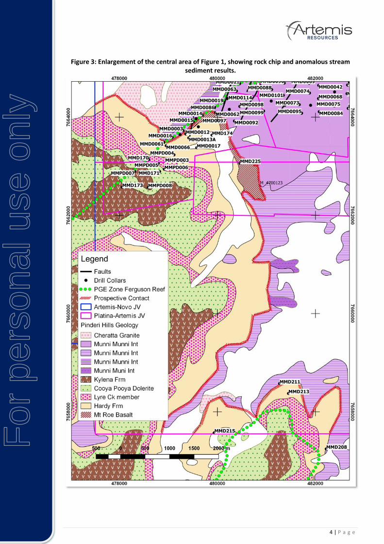
Figure 3: Enlargement of the central area of Figure 1, showing rock chip and anomalous stream sediment results.
For
per
sona
l use
onl
y

5 | P a g e
Figure 4: Artemis Resources Projects in Karratha Area.
CONTACTS: For further information on this update or the Company generally, please visit our website at www.artemisresources.com.au or contact: Investors / Shareholders Edward Mead Executive Director Telephone: +61 407 445 351 Email: [email protected] BACKGROUND INFORMATION ON ARTEMIS RESOURCES: Artemis Resources Limited is a resources exploration and development company with a focus on its prospective Karratha (gold, cobalt, base metals, platinum group elements and iron ore) and the Mt Clement Paulsens (gold) project in Western Australia. Artemis owns the fully permitted 425,000tpa Radio Hill nickel and copper operations and processing plant located 25km south of Karratha. JORC 2004 compliant resources of Gold, Nickel, Copper PGE's and Zinc, all situated within a 40km radius of the Radio Hill plant and on 1,536km2 form the newly consolidated assets of Artemis Resources.
For
per
sona
l use
onl
y
6 | P a g e
Artemis have signed Definitive Agreements with Novo Resources Corp. (“Novo”), whereby Novo can farm-in to 50% of gold (and other minerals necessarily mined with gold) in conglomerate and/or paleoplacer style mineralization in Artemis’ tenements within 100km of the City of Karratha, including at Purdy’s Reward (“the Gold Rights”). The Gold Rights do not include (i) gold disclosed in Artemis’ existing (at 18 May 2017) JORC compliant Resources and Reserves or (ii) gold which is not within conglomerate and/or paleoplacer style mineralization or (iii) minerals other than gold. Artemis’ Mt Oscar tenement is excluded from the Definitive Agreements. The farm-in commitment now requires Novo to expend AUD $2 million on exploration within two years of satisfying conditions precedent in the definitive agreements. The Definitive Agreements cover 38 tenements/tenement applications that are 100% owned by Artemis. On completion of the farm-in commitment, three 50:50 joint ventures will be formed between Novo’s subsidiary, Karratha Gold Pty Ltd (“Karratha Gold”) and three subsidiaries of Artemis. The joint ventures will be managed as one by Karratha Gold. Artemis and Novo will contribute to further exploration and mining of the Gold Rights on a 50:50 basis. Further definitive agreements covering approximately 19 Artemis tenements/tenement applications that are already subject to third party interests are expected to be signed once all necessary third-party consents have been obtained. COMPETENT PERSONS STATEMENT: The information in this document that relates to Exploration Results and Exploration Targets is based on information compiled or reviewed by Allan Younger, who is a Member of the Australasian Institute of Mining and Metallurgy. Mr Younger is a consultant to the Company, and is employed by Indigo Geochemistry Pty Ltd. Mr Younger has sufficient experience which is relevant to the style of mineralisation and type of deposit under consideration and to the activity which he is undertaking to qualify as a Competent Person as defined in the 2012 Edition of the ‘Australasian Code for Reporting of Exploration Results, Mineral Resources and Ore Reserves’. Mr Younger consents to the inclusion in the report of the matters based on his information in the form and context in which it appears. FORWARD LOOKING STATEMENTS AND IMPORTANT NOTICE: This report contains forecasts, projections and forward-looking information. Although the Company believes that its expectations, estimates and forecast outcomes are based on reasonable assumptions it can give no assurance that these will be achieved. Expectations, estimates and projections and information provided by the Company are not a guarantee of future performance and involve unknown risks and uncertainties, many of which are out of Artemis’ control. Actual results and developments will almost certainly differ materially from those expressed or implied. Artemis has not audited or investigated the accuracy or completeness of the information, statements and opinions contained in this presentation. To the maximum extent permitted by applicable laws, Artemis makes no representation and can give no assurance, guarantee or warranty, express or implied, as to, and takes no responsibility and assumes no liability for (1) the authenticity, validity, accuracy, suitability or completeness of, or any errors in or omission from, any information, statement or opinion contained in this report and (2) without prejudice to the generality of the foregoing, the achievement or accuracy of any forecasts, projections or other forward looking information contained or referred to in this report. Investors should make and rely upon their own enquiries before deciding to acquire or deal in the Company’s securities.
For
per
sona
l use
onl
y

7 | P a g e
JORC Code, 2012 Edition – Table 1
Section 1 Sampling Techniques and Data
(Criteria in this section apply to all succeeding sections.)
Criteria JORC Code explanation Commentary
Sampling techniques
• Nature and quality of sampling (eg cut channels, random chips, or specific specialised industry standard measurement tools appropriate to the minerals under investigation, such as down hole gamma sondes, or handheld XRF instruments, etc.). These examples should not be taken as limiting the broad meaning of sampling.
• Include reference to measures taken to ensure sample representivity and the appropriate calibration of any measurement tools or systems used.
• Aspects of the determination of mineralisation that are Material to the Public Report.
• In cases where ‘industry standard’ work has been done this would be relatively simple (eg ‘reverse circulation drilling was used to obtain 1 m samples from which 3 kg was pulverised to produce a 30 g charge for fire assay’). In other cases more explanation may be required, such as where there is coarse gold that has inherent sampling problems. Unusual commodities or mineralisation types (eg submarine nodules) may warrant disclosure of detailed information.
• Sampling core will be commenced after logging.
Drilling techniques
• Drill type (eg core, reverse circulation, open-hole hammer, rotary air blast, auger, Bangka, sonic, etc.) and details (eg core diameter, triple or standard tube, depth of diamond tails, face-sampling bit or other type, whether core is oriented and if so, by what method, etc.).
• Historical diamond core and RC chips
Drill sample recovery
• Method of recording and assessing core and chip sample recoveries and results assessed.
• Measures taken to maximise sample recovery and ensure representative nature of the samples.
• Whether a relationship exists between sample recovery and grade and whether sample bias may have occurred due to preferential loss/gain of fine/coarse material.
• Drilling not being hosted.
Logging • Whether core and chip samples have been geologically and geotechnically logged to a level of detail to support appropriate Mineral Resource estimation, mining studies and metallurgical studies.
• Whether logging is qualitative or quantitative in nature. Core (or costean, channel, etc.) photography.
• The total length and percentage of the relevant intersections logged.
• Geological logging being undertaken
Sub-sampling
• If core, whether cut or sawn and whether quarter, half or all core taken.
• No sampling as yet.
For
per
sona
l use
onl
y

8 | P a g e
Criteria JORC Code explanation Commentary
techniques and sample preparation
• If non-core, whether riffled, tube sampled, rotary split, etc. and whether sampled wet or dry.
• For all sample types, the nature, quality and appropriateness of the sample preparation technique.
• Quality control procedures adopted for all sub-sampling stages to maximise representivity of samples.
• Measures taken to ensure that the sampling is representative of the in situ material collected, including for instance results for field duplicate/second-half sampling.
• Whether sample sizes are appropriate to the grain size of the material being sampled.
Quality of assay data and laboratory tests
• The nature, quality and appropriateness of the assaying and laboratory procedures used and whether the technique is considered partial or total.
• For geophysical tools, spectrometers, handheld XRF instruments, etc., the parameters used in determining the analysis including instrument make and model, reading times, calibrations factors applied and their derivation, etc.
• Nature of quality control procedures adopted (eg standards, blanks, duplicates, external laboratory checks) and whether acceptable levels of accuracy (i.e. lack of bias) and precision have been established.
• No samples submitted
Verification of sampling and assaying
• The verification of significant intersections by either independent or alternative company personnel.
• The use of twinned holes.
• Documentation of primary data, data entry procedures, data verification, data storage (physical and electronic) protocols.
• Discuss any adjustment to assay data.
• No verification sampling has been undertaken.
Location of data points
• Accuracy and quality of surveys used to locate drill holes (collar and down-hole surveys), trenches, mine workings and other locations used in Mineral Resource estimation.
• Specification of the grid system used.
• Quality and adequacy of topographic control.
• Grid system used for sampling is MGA 94 (Zone 50)
Data spacing and distribution
• Data spacing for reporting of Exploration Results.
• Whether the data spacing and distribution is sufficient to establish the degree of geological and grade continuity appropriate for the Mineral Resource and Ore Reserve estimation procedure(s) and classifications applied.
• Whether sample compositing has been applied.
• Sampling not commenced.
• No compositing applied.
Orientation of data in relation to geological structure
• Whether the orientation of sampling achieves unbiased sampling of possible structures and the extent to which this is known, considering the deposit type.
• If the relationship between the drilling orientation and the orientation of key
• Sampling will be controlled based on geological logging.
For
per
sona
l use
onl
y

9 | P a g e
Criteria JORC Code explanation Commentary
mineralised structures is considered to have introduced a sampling bias, this should be assessed and reported if material.
Sample security
• The measures taken to ensure sample security.
• Chain of custody maintained until delivered to laboratory.
Audits or reviews
• The results of any audits or reviews of sampling techniques and data.
• No audit of rock sampling data has been completed to date
Section 2 Reporting of Exploration Results
(Criteria listed in the preceding section also apply to this section.)
Criteria JORC Code explanation Commentary
Mineral tenement and land tenure status
• Type, reference name/number, location and ownership including agreements or material issues with third parties such as joint ventures, partnerships, overriding royalties, native title interests, historical sites, wilderness or national park and environmental settings.
• The security of the tenure held at the time of reporting along with any known impediments to obtaining a licence to operate in the area.
• E47/3322 is in good standing and is 100% owned by Karratha Metals Ltd.
• M47/123-126 owned by Platina Resources Ltd.
• See map elsewhere in this report for locations.
Exploration done by other parties
• Acknowledgment and appraisal of exploration by other parties.
• Intensive exploration of the Munni Munni intrusive complex for PGE resources has been undertaken by Greater Pacific Investments, Hunter Resources, Helix Resources and Platina Resources.
• They undertook mapping, drilling, geophysical surveys, geochemical surveys, economic studies and heritage surveys.
Geology • Deposit type, geological setting and style of mineralisation.
• The study currently being undertaken is to investigate the potential for gold mineralisation associated with basal siliceous conglomerate lithologies.
• This totally independent of the defined mafic intrusive hosted PGE mineralisation.
Drill hole Information
• A summary of all information material to the understanding of the exploration results including a tabulation of the following information for all Material drill holes: o easting and northing of the drill
hole collar o elevation or RL (Reduced Level –
elevation above sea level in metres) of the drill hole collar
o dip and azimuth of the hole o down hole length and interception
depth o hole length.
• If the exclusion of this information is justified on the basis that the information is not Material and this exclusion does not detract from the understanding of the report, the Competent Person should clearly explain why this is the case.
• Historical drill collars were surveyed, with downhole surveys being completed; downhole logging was occasionally performed. .
Data aggregation methods
• In reporting Exploration Results, weighting averaging techniques, maximum and/or minimum grade truncations (eg cutting of high grades)
• No aggregation methods being applied.
For
per
sona
l use
onl
y

10 | P a g e
Criteria JORC Code explanation Commentary
and cut-off grades are usually Material and should be stated.
• Where aggregate intercepts incorporate short lengths of high grade results and longer lengths of low grade results, the procedure used for such aggregation should be stated and some typical examples of such aggregations should be shown in detail.
• The assumptions used for any reporting of metal equivalent values should be clearly stated.
Relationship between mineralisation widths and intercept lengths
• These relationships are particularly important in the reporting of Exploration Results.
• If the geometry of the mineralisation with respect to the drill hole angle is known, its nature should be reported.
• If it is not known and only the down hole lengths are reported, there should be a clear statement to this effect (eg ‘down hole length, true width not known’).
• No mineralisation widths are being reported.
Diagrams • Appropriate maps and sections (with scales) and tabulations of intercepts should be included for any significant discovery being reported These should include, but not be limited to a plan view of drill hole collar locations and appropriate sectional views.
• Appropriate maps and sections are available in the body of this announcement.
• The geology shown is based on the GSWA Pinderi Hills 1:100,000 mapsheet.
Balanced reporting
• Where comprehensive reporting of all Exploration Results is not practicable, representative reporting of both low and high grades and/or widths should be practiced to avoid misleading reporting of Exploration Results.
• Reporting of results in this report is considered balanced.
Other substantive exploration data
• Other exploration data, if meaningful and material, should be reported including (but not limited to): geological observations; geophysical survey results; geochemical survey results; bulk samples – size and method of treatment; metallurgical test results; bulk density, groundwater, geotechnical and rock characteristics; potential deleterious or contaminating substances.
• No other significant exploration work has been done by Artemis.
Further work • The nature and scale of planned further work (eg tests for lateral extensions, depth extensions or large-scale step-out drilling).
• Diagrams clearly highlighting the areas of possible extensions, including the main geological interpretations and future drilling areas, provided this information is not commercially sensitive.
• Plans are to follow-up re-logging of geology from drilling, with sampling and assays, with mapping and sampling, and with further drilling.
For
per
sona
l use
onl
y