ararat wind farm geology and hydrology...
TRANSCRIPT
Murra Warra Solar Farm
Geology and Hydrology Assessment Report
Author: RES Australia Date: 18 November 2016

Murra Warra Solar Farm Geology & Hydrology Assessment Report
Page | 2
Revision History
Issue Date Author Nature And Location Of Change
Draft 01 18 Nov 2016 Hayden Vink/Justin Howes
Draft for Internal Review

Murra Warra Solar Farm Geology & Hydrology Assessment Report
Page | 3
CONTENTS
EXECUTIVE SUMMARY 5
1 INTRODUCTION 6
2 PROJECT DESCRIPTION 7
3 GEOLOGY 10
3.1 Topography 10 3.1 Soils 10 3.2 Regional Geology 11 3.3 Seismicity 13 3.4 Local Geology 13 3.5 Quarry Development 17
4 HYDROLOGY 18
4.1 Regional Hydrology 18 4.2 Receiving Water Environments 19 4.3 Local Hydrology 19 4.4 Water Supply 20 4.5 Groundwater 21 4.6 Rainfall 24 4.7 Site Drainage 26
5 DESIGN CONSIDERATION 27
5.1 Access Tracks and Hardstandings 27 5.2 Racking Foundations 27
6 CONSTRUCTION MITIGATION MEASURES 28
6.1 Access Tracks and Hardstandings 28 6.2 Racking Foundations 29
7 OPERATIONAL MITIGATION MEASURES 31
8 FURTHER INVESTIGATIONS 32
9 CONCLUSIONS 33
APPENDIX A - DRAWINGS 34
APPENDIX B – GEOLOGICAL MAPS 35
APPENDIX C – BOREHOLE LOGS 36
APPENDIX D – FLOOD MAPS 37
Figures
Figure 1 – Site Location Showing Grampians (dark green region) to the South ............................................ 7
Figure 2 Typical Fixed Mounting Structure ..................................................................................................... 8
Figure 3 – Typical Single Axis Tracking Mounting Structure ........................................................................... 8
Murra Warra Solar Farm Geology & Hydrology Assessment Report
Page | 4
Figure 4 - Site topography – Dimboola Minyip Road at intersection with Dogwood Road ........................ 10
Figure 5 - Regional Geology (250k Seamless – source http://er-info.dpi.vic.gov.au/) ................................ 12
Figure 6 - Murray Basin Base Rock Structure Contours in Metres ............................................................... 13
Figure 7 - Basement Geology Cross Section .................................................................................................. 13
Figure 8 - Existing Groundwater Bore – Minyip-Dimboola Road at the intersection of Ailsa Wheat Road (location of proposed Solar farm can be seen in the background) .............................................................. 14
Figure 9 – Photo of Existing Groundwater Bore ........................................................................................... 15
Figure 10 - Schematic Showing Obsolete Open Channel Water Distribution Network .............................. 20
Figure 11 - Victorian Groundwater Management Framework..................................................................... 22
Figure 12 - Monitored Water Level - Groundwater Borehole 70221 .......................................................... 23
Figure 13 - Design Rainfall Intensity Chart .................................................................................................... 25
Figure 14 - Schematic Cross Sections of Solar farm Tracks .......................................................................... 26
Figure 15 – Example pile installation (drilled) ............................................................................................... 29
Figure 16 – Example pile installation (driven) ............................................................................................... 29
Tables
Table 1 - Summary of Groundwater Boreholes within Proposed Site ......................................................... 15
Table 2 - Summary of State Groundwater Borehole 70221 ......................................................................... 16
Table 3 - Summary of Groundwater Chemistry within Proposed Site ......................................................... 21
Table 4 - Average rainfall and temperatures ................................................................................................ 24
Table 5 - Murra Warra Rainfall Intensities (mm/hr) ..................................................................................... 25
Murra Warra Solar Farm Geology & Hydrology Assessment Report
Page | 5
EXECUTIVE SUMMARY
RES Australia Pty Ltd is seeking to develop a Solar farm facility which is expected to have an installed capacity of up to 235MW, provided by up to 900,000 solar photovoltaic (PV) panels, and associated infrastructure. The proposed Solar farm site is located in the south east corner of the Murra Warra Solar farm site, located approximately 32 km northeast of Horsham and immediately south of the section of Minyip-Dimboola Road that runs between the Blue Ribbon Road and the Henty Highway. The site has a total development area of approximately 370 hectares and is located adjacent to the proposed Murra Warra Solar farm site (with a total area of 4,200 hectares). The site is currently utilised for broad acre cropping and stock grazing.
This Geology and Hydrology Assessment Report has been prepared to ensure the Solar farm Project proceeds with minimum disruption to the regional and local environment and its preparation has drawn upon feedback from key stakeholders, various desktop studies and site test pits and inspections completed in September 2015.
The proposed Solar farm is situated in the Murray Basin geological area and consists of many layers of “recent” marine and freshwater / estuarine sediments of approximate total depth 140m overlying the cratonic base rock formations of the East Australian great dividing range which dating from the Cambrian to Ordovician period. The topography of the site is basically featureless being extremely flat with a general fall of 1m in 1000m towards the Murray River into which the general basin area drains to the north. No significant earthworks will be necessary for the construction of the project. It is anticipated that a Quarry, developed as part of the wider Murra Warra Wind Farm project, will be able to supply adequate materials for the project in order to minimise the amount of truck movements associated with track construction. Use of the quarry will be subject to permitting of the wind farm and works approval, which may need to be amended.
There are no designated waterways or even minor streams within the site area. The obsolete open channel rural water supply system is being filled on an ad hoc basis and these channels are not required for local storm water control. The site is about 7km west of the Yarriambiack Creek but is not in an area prone to flooding and was not inundated during the Wimmera River flood event of 2010 – 2011 when the Yarriambiack Creek flowed for the first time in 15 years. Given the flat nature of the site it is not anticipated that any construction works will cause scour or adverse sedimentation impacts in the area.
The open channel rural water supply system was replaced with a piped system in the Wimmera region between 2006 and 2010, and this water is expected to be drawn upon for construction purposes. Alternatively, groundwater bores may be able to be used for road building purposes and dust suppression only. The salinity of the groundwater is high there is no noteworthy beneficial use of it for agricultural or residential / commercial purposes in the area. The groundwater table is approximately 30m deep at the centre of the project site and no excavations or quarrying activities during construction will intercept it. Standard construction environmental controls will be able to mitigate against minor adverse impacts the works may cause to both surface and groundwater resource.
Based on an assessment of the subject site’s geology and hydrology features, it is considered that the granting of consent for the development of a proposed Solar farm Project would not result in any significant adverse impact upon the soil and water features of the subject site and surrounding area and the proposal would be capable of complying with relevantly applicable legislation and guidelines.
Murra Warra Solar Farm Geology & Hydrology Assessment Report
Page | 6
1 INTRODUCTION
RES Australia Pty Ltd is a 100% owned subsidiary of the Renewable Energy Systems group of companies (RES Group). RES Group is a specialist renewable energy developer with 30 years’ experience. To date RES Group has built renewable energy projects of over 10 GW around the world (with another 1.7 GW currently under construction).
RES Australia has staff located in both Victoria and New South Wales and is currently developing a number of other sites in Victoria, New South Wales and South Australia.
This report describes the existing soil and water conditions at the site of the proposed Murra Warra Solar farm project. The proposed Solar farm site is located in the south east corner of the Murra Warra Solar farm site, over an area with similar topography and landform.
The report considers the potential for any impact of the project upon the existing soil and water conditions; and recommends design principles and construction methodologies to mitigate against any impact.
The report draws on;
Feedback and discussion with key stakeholders (GMW Water, Yarriambiack Shire Council and Horsham Rural City Council and the Wimmera Catchment Management Authority),
Published reports and maps;
Various desktop studies,
On-site inspections undertaken by RES Australia’s construction manager and Civil Engineer,
RES Australia is committed to delivering the Murra Warra Solar farm Project with minimum disruption to the regional and local environment of which the Hydrology and Geology subset form a part.
Murra Warra Solar Farm Geology & Hydrology Assessment Report
Page | 7
2 PROJECT DESCRIPTION
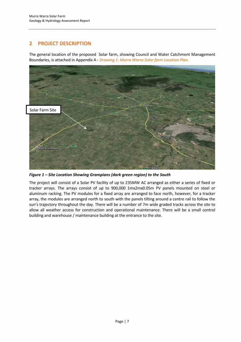
The general location of the proposed Solar farm, showing Council and Water Catchment Management Boundaries, is attached in Appendix A - Drawing 1: Murra Warra Solar farm Location Plan.
Figure 1 – Site Location Showing Grampians (dark green region) to the South
The project will consist of a Solar PV facility of up to 235MW AC arranged as either a series of fixed or tracker arrays. The arrays consist of up to 900,000 1mx2mx0.05m PV panels mounted on steel or aluminum racking. The PV modules for a fixed array are arranged to face north, however, for a tracker array, the modules are arranged north to south with the panels tilting around a centre rail to follow the sun’s trajectory throughout the day. There will be a number of 7m wide graded tracks across the site to allow all weather access for construction and operational maintenance. There will be a small control building and warehouse / maintenance building at the entrance to the site.
Warracknabeal
Solar Farm Site

Murra Warra Solar Farm Geology & Hydrology Assessment Report
Page | 8
Figure 2 Typical Fixed Mounting Structure
Figure 3 – Typical Single Axis Tracking Mounting Structure
Power from the panels will be inverted from direct current (DC) to alternating current (AC)and then transformed to 33kV and transported back to a central collector point located in the northwest of the site close to the location of the control building and maintenance facilities. Power will then be carried along a double circuit 33kV line which runs to the north of the Solar farm for approximately 2km and turns west to the site of the proposed terminal station for Murra Warra Wind Farm. There will be a metering point and some reactive power plant at the terminal station. Power will then be exported to the grid via the Solar farm 33kV to 220kV transformer.
The project will also include a 300Mwh battery storage facility which will comprise of banks of Lithium Ion batteries and control equipment which will be housed in a purpose built single storey building of approximately 85mx22m. This facility would be enclosed in a secure compound.

Murra Warra Solar Farm Geology & Hydrology Assessment Report
Page | 9
The project may include some stock proof fencing of up to 2m height and CCTV security cameras depending on insurance requirements.
There will be up to three temporary construction compounds across the whole development site which will house laydown areas, batch plant, offices etc. These facilities will be removed once work has been completed and the land rehabilitated. There will be two compunds to service the Solar farm development itself and one located near the battery storage and metering point in proximity to the termninal station. These facilities will be removed once the work has been completed and the land rehabilited.
Murra Warra Solar Farm Geology & Hydrology Assessment Report
Page | 10
3 GEOLOGY
3.1 Topography
LIDAR data has been obtained for the Solar farm site and this is shown in Appendix A, Drawing 2: Murra Warra Solar and Solar farm Site Topography and Drainage. The overall Solar farm site generally falls from north to south. There is a “shallow ridge” line running approx. 2km west of the site in the same direction that may be part of an old sand dune / marine formation of the underlying Loxton Sands.
Levels typically range from RL130-134m at the southern extents of the Solar farm site, falling to RL124m at the northern extent adjacent to Barrett Road. The proposed Solar farm site is generally flat at RL129m with no notable topographic features. The south eastern corner of the site rises locally to RL130m.
The bed of the Yarriambiack Creek is generally at RL118-120m in the vicinity of the site.
The maximum track slope is expected to be in the order of 2-3%. From an engineering perspective the site can be considered flat and there will be no significant geotechnical terrain related risks to overcome during construction of the Solar farms.
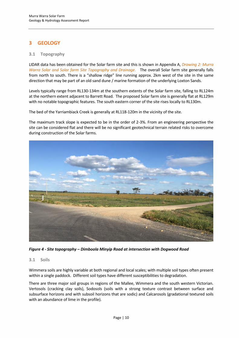
Figure 4 - Site topography – Dimboola Minyip Road at intersection with Dogwood Road
3.1 Soils
Wimmera soils are highly variable at both regional and local scales; with multiple soil types often present within a single paddock. Different soil types have different susceptibilities to degradation.
There are three major soil groups in regions of the Mallee, Wimmera and the south western Victorian. Vertosols (cracking clay soils), Sodosols (soils with a strong texture contrast between surface and subsurface horizons and with subsoil horizons that are sodic) and Calcarosols (gradational textured soils with an abundance of lime in the profile).

Murra Warra Solar Farm Geology & Hydrology Assessment Report
Page | 11
Vertosols are often called cracking clay soils. They have a clay texture (>35% clay) throughout the profile; display strong cracking when dry, and shrink and swell considerably during wetting and drying phases. Based on colour of the upper 50 cm of the soil profile, they can be grouped into suborders. Grey Vertosols are the most common in the Wimmera, with minor occurrences of Red and Brown Vertosols. Self-mulching Vertosol soils are common in the Horsham and Kaniva regions.
Sodosols occur on a wide range of landforms (from gently undulating plains and rises to undulating low hills). Surface soil textures and depths vary considerably and have significant implications for management. Sodosols tend to be found mainly in the southern, eastern and western Wimmera with smaller areas in the northern Mallee and east of Birchip. Sodosols are also common on basalt plains and rises throughout much of south-western Victoria. They are also common on sedimentary plains and rises in lower rainfall areas. The subsoils of Sodosols in the region often display a strong shrinking and swelling characteristic i.e. vertic, and the subsurface horizons can be ferric i.e. contain significant amounts of ferruginous nodules ‘buckshot’.
Calcarosols do not have a strong texture contrast between surface and subsurface horizons and are calcareous throughout. They often contain calcium carbonate (lime) as soft or hard fragments. They are most common in the north-east of the region. Calcarosols (often called ‘mallee loams’, ‘mallee sands’ or ‘calcareous earths’) are soils formed on calcareous aeolian sediments of variable texture. Calcarosols vary quite considerably in terms of soil texture, ranging from those dominated by sands to those that are clayey throughout, and this has a big influence on the agronomic properties of the land. Three kinds of Calcarosols occur: light textured (sandy to loamy), heavy textured (clay loamy to clay) and stony.
3.2 Regional Geology
To the East of the proposed Solar farm, a multifaceted history of massive tectonic events has formed what is now the eastern seaboard area of Australia. The formation of this eastern zone is characterised by uplift, folding, faulting, volcanic intrusion and the resultant metamorphosing of ancient marine mudstones and sandstones, circa 450+ Million Years ago. The Grampians Ranges and Mt Arapiles, to the south and west of Horsham respectively, are considered to be the southern visible extremity of this Great Dividing Range / Eastern Seaboard Highlands geological system which runs to the far north of Queensland.
This complex Cratonic activity to the east (and which also underlies the site in the base rock formations) is also responsible for the formation of the Murray - Darling basin / river system in which the subject Solar farm lies. The exit point of the Murray River and the position of the coast line to the southwest of the site has changed frequently in the past during various periods of high sea level and associated receding of the shoreline within what is now the basin. Thus, the site area has been subjected to patterns of marine inundation, and coastal lake and river system formation which have laid down sediments on top of the base rock features over time. The uppermost layer of these marine sediments, described as “Loxton Sands” (Nwl), have also recently been subject to the deposition of alluvial / floodplains material, as with the “Shepparton Formation” (Nws) that exist to the south and east of the site. These units are described on the Australian Stratigraphic Units Database as follows5
“Shepparton Formation (Nws) - Unconsolidated to poorly consolidated mottled variegated clay, silty clay with lenses of polymictic, coarse to fine sand and gravel; partly modified by pedogenesis, includes intercalated red-brown paleosols. Forms extensive flat alluvial floodplains. circa 20 to 30 thousand years ago”. Shepparton Formation Overlies:
Murra Warra Solar Farm Geology & Hydrology Assessment Report
Page | 12
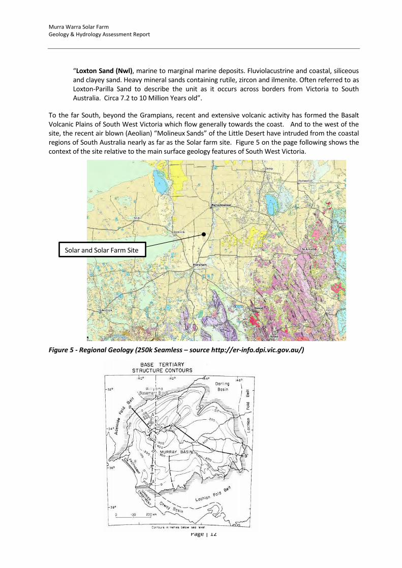
“Loxton Sand (Nwl), marine to marginal marine deposits. Fluviolacustrine and coastal, siliceous and clayey sand. Heavy mineral sands containing rutile, zircon and ilmenite. Often referred to as Loxton-Parilla Sand to describe the unit as it occurs across borders from Victoria to South Australia. Circa 7.2 to 10 Million Years old”.
To the far South, beyond the Grampians, recent and extensive volcanic activity has formed the Basalt Volcanic Plains of South West Victoria which flow generally towards the coast. And to the west of the site, the recent air blown (Aeolian) “Molineux Sands” of the Little Desert have intruded from the coastal regions of South Australia nearly as far as the Solar farm site. Figure 5 on the page following shows the context of the site relative to the main surface geology features of South West Victoria.
Figure 5 - Regional Geology (250k Seamless – source http://er-info.dpi.vic.gov.au/)
Solar and Solar Farm Site

Murra Warra Solar Farm Geology & Hydrology Assessment Report
Page | 13
Figure 6 - Murray Basin Base Rock Structure Contours in Metres
The depths of Loxton Sands (formally designated as Parilla Sand, Tpp), plus other various underlying sedimentary deposits within the Murray Basin can vary from tens of metres to hundreds of metres depending on the distance from the edge of the basin as shown left in Figure 6ref1.
The underlying Cratonic base rock at the Solar farm site has been specifically mappedref2 as “St Arnard Group” (cmt) basalts and volcanclastics dating from the Cambrian to Ordovician period, circa 440 Million Years Ago. This baserock falls within the Stawell Folding / Faulting Zone of rock formation as shown on the Rock Relationship Diagram below in Figure 7. More recent granitic intrusions such as those designated (Dgm and Dglm etc.) date from 400 to 370 Million years ago.
The “approximate” location of the Solar farm site with regards to base rock geology structures is indicated by the vertical red line, it should be noted that the basin sediments shown on top of the base rock in the figure is simplification.
Figure 7 - Basement Geology Cross Section
3.3 Seismicity
Based on AS1170.4-2007 “Structural Design Actions Part: 4, Earthquake actions in Australia”, section 3, the hazard factor (Z) for the site is 0.08 (0.08 in 500 years probability of exceedance).
Based on the subsurface conditions at the site a Sub-Soil classification of either Class C (Shallow Soil) or D (Deep) is likely to be assigned to the site at the detailed design stage of the project as per section 4 of AS1170.4.
3.4 Local Geology
The subject Solar farm site is located in an area of deep sedimentary deposits of both marine (Loxton Sands and underlying deposits) and alluvial (Shepparton Formation) origin as discussed in the section
1 C.M BROWN. Murray Basin, Southeastern Australia: stratigrpahy and resource potential a synopsis, 1985, Report
246
2 Horsham 1:250,000 Geophysical Interpretation of Basement Geology, 1996.
Site location
Horsham
A
Otway Group
Murra Warra Solar Farm Geology & Hydrology Assessment Report
Page | 14
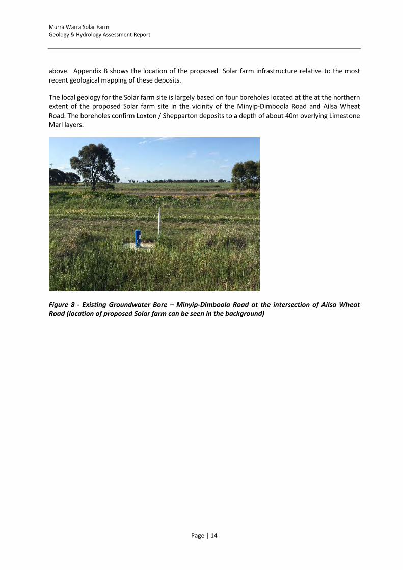
above. Appendix B shows the location of the proposed Solar farm infrastructure relative to the most recent geological mapping of these deposits.
The local geology for the Solar farm site is largely based on four boreholes located at the at the northern extent of the proposed Solar farm site in the vicinity of the Minyip-Dimboola Road and Ailsa Wheat Road. The boreholes confirm Loxton / Shepparton deposits to a depth of about 40m overlying Limestone Marl layers.
Figure 8 - Existing Groundwater Bore – Minyip-Dimboola Road at the intersection of Ailsa Wheat Road (location of proposed Solar farm can be seen in the background)
Murra Warra Solar Farm Geology & Hydrology Assessment Report
Page | 15
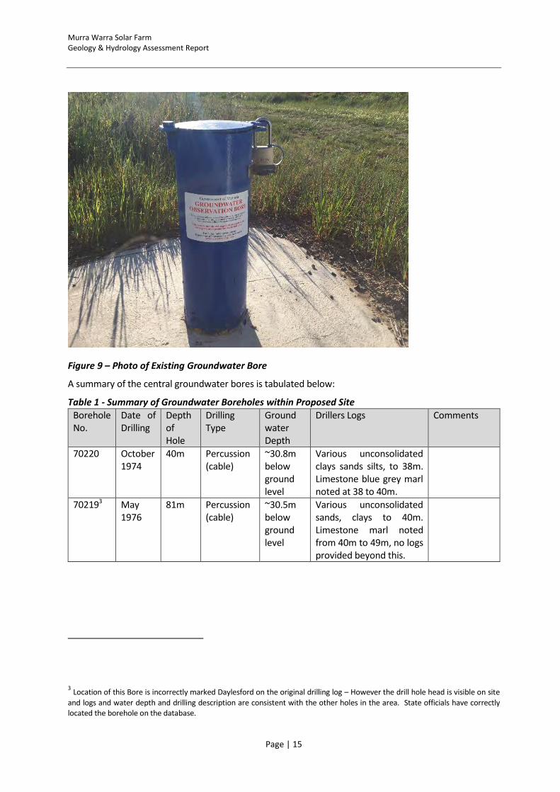
Figure 9 – Photo of Existing Groundwater Bore
A summary of the central groundwater bores is tabulated below:
Table 1 - Summary of Groundwater Boreholes within Proposed Site
Borehole No.
Date of Drilling
Depth of Hole
Drilling Type
Ground water Depth
Drillers Logs Comments
70220 October 1974
40m Percussion (cable)
~30.8m below ground level
Various unconsolidated clays sands silts, to 38m. Limestone blue grey marl noted at 38 to 40m.
702193 May 1976
81m Percussion (cable)
~30.5m below ground level
Various unconsolidated sands, clays to 40m. Limestone marl noted from 40m to 49m, no logs provided beyond this.
3 Location of this Bore is incorrectly marked Daylesford on the original drilling log – However the drill hole head is visible on site
and logs and water depth and drilling description are consistent with the other holes in the area. State officials have correctly located the borehole on the database.
Murra Warra Solar Farm Geology & Hydrology Assessment Report
Page | 16
70221 10 Oct 1988
144.2 Rotary and Core Samples
~31.2m below ground level
Driller’s logs similar to above, limestones noted at 45.5m.
Stratigraphy provided and 4 Cores taken - see table 2 below.
70222 26 Oct 1988
48 Rotary ~30.3m below ground level
Various clays and gravels to 38m depth. 38 to 48m, marl and limestone.
Borehole 70221 is the most detailed of the drill holes and 4 cores samples were taken from this hole during drilling in 1988. The drillers log and inferred stratigraphy for this hole are summarised on the table below:
Table 2 - Summary of State Groundwater Borehole 70221
Depth Depth Material Comments Core Taken Stratigraphy Log
0m 1.5m Brown Clay Brown Clay No
1.5m 6.5m White Clay White Clay no
6.5m 8.2m Clay Reddy Clay no 6-32m Loxton Sands
8.2m 15.5m Sand Brown sand medium no
15.5m 19.6m Gravel Coarse gravels no
19.6m 38.8m Silt Yellow silts and ironstone bands
23-26m
38.8m 43m Clay Grey clay 41-43.5m 32-52m Geera Clay
43m 45.5m Limestone Fossilised limestones no
45.5m 115.5m Limestone Grey marl no 52-101 Olney Formation
115.5m 135m Clay White silts and clays 119-120m
135m 144.2m Silt Orange silts and clays layered
141.4-144.2
END Base Rock not indicated
In summary, the surface materials expected over the extent of the site are not anticipated to provide any significant challenge with respect to foundation construction.
It is considered highly unlikely that any of the Project works will encounter acid sulphate soils (ASS) given the site location and local geology, the shallow nature of the proposed works (<10m) and depth to groundwater (>20m). An assessment of the soil acidity will however be undertaken prior to construction works commence with turbine foundation concrete mix specifications adjusted accordingly.
A review of the published map4 of ‘Sites of Geological and Geomorphological Significance’ shows that there are none located within 50km of the Solar Farm site.
4 http://vro.agriculture.vic.gov.au/dpi/vro/portregn.nsf/pages/port_lf_ppsites_sig
Murra Warra Solar Farm Geology & Hydrology Assessment Report
Page | 17
3.5 Quarry Development
As part of the wider Wind Farm Project RES Australia intends to develop a quarry on site for the sole purpose of serving the Wind Farm. This quarry could, subject to permitting, also supply suitable subbase material for the Solar farm project and reduce the number of deliveries required for construction of tracks and hardstands.
Refer to the Geology & Hydrology Assessment Report and Quarry Work Plan prepared for the Murra Warra Solar farm development for details of the proposed quarry.

Murra Warra Solar Farm Geology & Hydrology Assessment Report
Page | 18
4 HYDROLOGY
4.1 Regional Hydrology
The Solar farm site is located within the Wimmera Catchment Management Authority (WCMA) region and lies between the Yarriambiack Creek and the Wimmera River, approximately halfway between the towns of Horsham and Warracknabeal.
The Wimmera River and its more ephemeral distributary, the Yarriambiack Creek both flow northwards from the Pyrenees Ranges and are ostensibly within the Southern Murray Darling basin - However the rivers are both “landlocked” and currently discharge into terminal lake / wetland systems that have never overflowed onwards to reach the Murray River in living memory5. Moreover, the most upstream terminal lake of the Wimmera, Lake Hindmarsh, was dry for fifteen years until the flooding / high rainfall events of late 2010 to early 2011.
The site is closer to the Yarriambiack Creek than the Wimmera River (approximately 7km west of the Yarriambiack Creek, 27km east of the Wimmera). The Yarriambiack Creek only flows during very high rainfall events being fed from via a bifurcation of the Wimmera River about 18km east of Horsham and 11km south of Jung. The Yarriambiack Creek has a series of weirs constructed along its length to hold water. Detailed 1:100 year flood mapping of the Yarriambiack Creek has been completed by the WCMA – this is partially shown in Appendix A – Drawing 3: Murra Warra Solar farm Regional Hydrology.
While the upper reaches of the Yarriambiack Creek, east of Horsham (in the Darlot Swamp) area, is prone to flooding during high flows, northwards of Jung, any floodwaters are retained tightly within the Yarriambiack Creek channel. The Yarriambiack Creek 100 year floodwater level at the closest point to the Solar farm site has been modelled to be at approx. RL121-122m. The Solar farm site is generally at an elevation of 129m.
Thus is all cases, the northward flowing 100 year floodwater of the Yarriambiack Creek is expected to be about 5m below the existing ground level within the Solar farm designation (and 7-8m below the proposed Solar farm site) and therefore it can be concluded that there is no significant risk of the site becoming flooded due to a regional flood event during the lifetime of the Solar farm and Connection Substation Facilities.
It is also important to note that the Solar farm project area, and more importantly the proposed sub-station location was not subject to flooding / inundation during the Wimmera region flooding of 2010 and 2011, during which the Yarriambiack Creek flowed for the first time in 15 years.
5 Further east of the Yarriambiack is the Avon / Richardson river which is also a northwards flowing landlocked river termiating at Lake Buloke.
East of the Avon / Richardson is the Avoca River that also flows northwards towards the Murray River reaching it intermitently during high flow periods.

Murra Warra Solar Farm Geology & Hydrology Assessment Report
Page | 19
4.2 Receiving Water Environments
The Yarriambiack Creek ultimately discharges to the north into the Lake Lascelles and Lake Coorong Reserve Area. These lakes are not listed on the ‘National dataset of Australia's Ramsar Wetlands’ or in the "Directory of Important Wetlands in Australia (DIWA)"
Both the Wimmera River and the most upstream terminal lake, Lake Hindmarsh, are listed as Nationally Important Wetlands. Lake Hindmarsh is the largest freshwater body in Victoria, supporting several significant water-bird species. Lake Albacutya, downstream of Lake Hindmarsh, is also listed as a wetland of international importance under the Ramsar Convention as it is a particularly good example of a near-natural wetland and it supports a large number of rare and threatened bird fauna. The Wimmera River is included in the Heritage Rivers Act 1992.
Given the considerably flat topography across the region, it is difficult to determine which parts of the Solar farm site will ultimately drain to the west (into the Wimmera System) or to the east (into the Yarriambiack Creek system).
This being said, given the small volumes of additional runoff from the Solar Farm development, nature of the topography and local drainage network and distance to the receiving waters, the effects on the environmental values of the receiving water environments, specifically the downstream terminal lakes, are considered to be negligible.
4.3 Local Hydrology
The subject site drains generally north and falls and the land falls at an approximate rate of 1m per 1,000m. The main Solar farm site is close to the now obsolete “Main Western” and “Rainbow” Channels that were formally part of the extensive 17,500km earthen open channel network that distributed water annually in the Wimmera and Mallee Regions. These open channels, managed by GWM, water have recently (2006 to 2010) been replaced with a 9,000km piped water distribution system which provides continuous pressurised water supplies to approximately 9,000 farms and 34 townships across the Wimmera and Mallee. As constructed plans of the pipeline are provided within Appendix E.
Murra Warra Solar Farm Geology & Hydrology Assessment Report
Page | 20
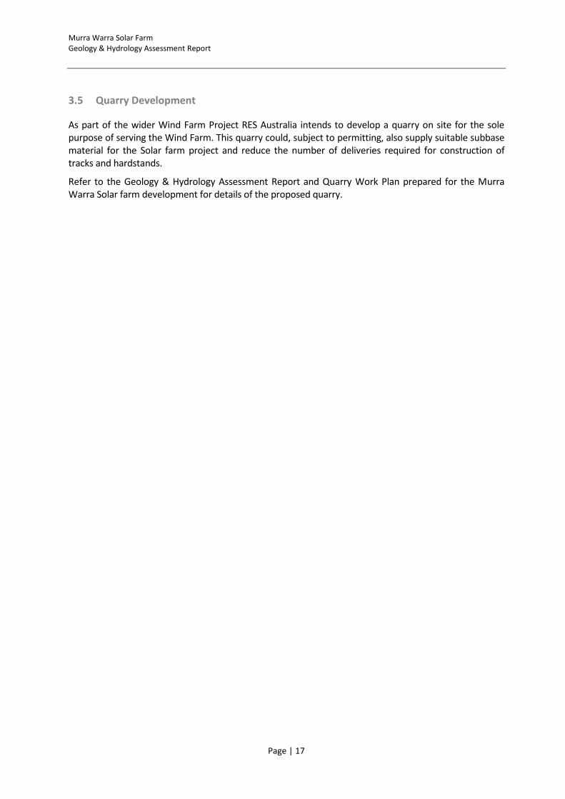
Figure 10 - Schematic Showing Obsolete Open Channel Water Distribution Network
The water distribution channels in the vicinity of the Solar Farm are not specifically required for flow management of local stormwater or as soak away storage for local surface runoff.
All channels on private property may be decommissioned (subject to consent being obtained) and the channel easements can be removed at the landowner’s expense.
Channels and their decommissioned water retention dams have been shown, along with other local hydrology features, in Appendix A - Drawing 2: Murra Warra Solar farm Site Topography and Drainage.
There are no designated waterways within the site that would require a Works on Waterways licence to be obtained.
4.4 Water Supply
The new piped water supply system administered by GWM Water is a potential source of water supply for the construction of the project. The Wimmera Mallee Pipeline delivers raw water to the towns and farming properties throughout the Wimmera and Sothern Mallee region. The pipeline is designed to trickle fill on-property storages throughout the day, rather than meet a peak hour demand, with most farming properties needing no more 10,000 L/day (average 0.12 L/s).
The project site is about 6 km away from the Jung to Warracknabeal 450 mm diameter trunk main. GWM Water have advised that:
Approx
location of site
Approx Wind Farm Site Extents
Proposed Solar Farm

Murra Warra Solar Farm Geology & Hydrology Assessment Report
Page | 21
- The flow rate to the project site is limited to 2 L/s (about 175 kL/day) - The water pipes leading up to the nominated site are too small for the flow rate of 5 L/s
(estimated flow requirement for the Solar farm construction) and would likely result in reduced supply to properties further along the pipeline.
- Options for an increased water supply include: 1. Construct a dedicated pipeline to the site from the 450 mm trunk main along the
Henty Highway – a temporary welded HDPE pipe along fence lines may be possible (the pressure at the trunk main is approximately 40m)
2. Construct a dedicated standpipe on the 450 mm trunk main along the Henty Highway and cart water.
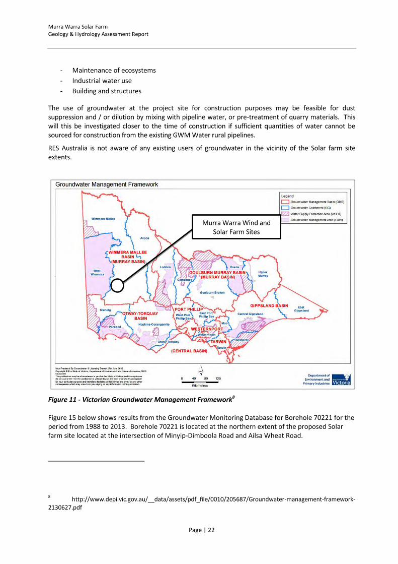
4.5 Groundwater
The Solar farm is situated east of the Wimmera River in an Unincorporated Area (UA) of the Murray Basin that is administered by Grampians Wimmera Mallee Water (GWM Water). UA’s cover the areas outside Water Supply Protection Areas and Groundwater Management Areas, where groundwater is not considered to be overutilised and therefore does not need any specific management prootcole to protect the resource.
A summary of the groundwater chemistry from the existing bores located at the at the northern extent of the proposed Solar farm site in the vicinity of the Minyip-Dimboola Road and Ailsa Wheat Road are tabulated below.
Table 3 - Summary of Groundwater Chemistry within Proposed Site6
Borehole No.
Depth of Hole
Ground water Depth
Electrical Conductivity –EC (mS/cm)
pH (pH) Total Dissolved Solids - TDS (mg/L)
702197 81m ~30.5m below ground level
22.00 7.50 12800.66
70221 144.2 ~31.2m below ground level
26.00 7.50 14869.60
70222 48 ~30.3m below ground level
14.00 7.60 7857.80
Regional mapping (Groundwater Resource Appriasal, 2010) suggests an upper aquifer salinity in the range of 8,000-15,000mg/L. Based on this salinity the groundwater beneficial uses (SEPP Groundwaters of Victoria) are limited to the following:
6 Source: Visualising Victoria’s Groundwater, http://www.vvg.org.au/
7 Location of this Bore is incorrectly marked Daylesford on the original drilling log – However the drill hole head is visible on site
and logs and water depth and drilling description are consistent with the other holes in the area. State officials have correctly located the borehole on the database.
Murra Warra Solar Farm Geology & Hydrology Assessment Report
Page | 22
- Maintenance of ecosystems
- Industrial water use
- Building and structures
The use of groundwater at the project site for construction purposes may be feasible for dust suppression and / or dilution by mixing with pipeline water, or pre-treatment of quarry materials. This will this be investigated closer to the time of construction if sufficient quantities of water cannot be sourced for construction from the existing GWM Water rural pipelines.
RES Australia is not aware of any existing users of groundwater in the vicinity of the Solar farm site extents.
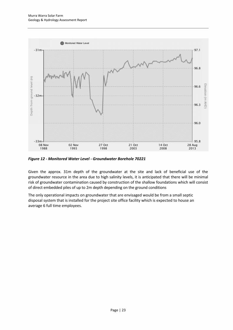
Figure 11 - Victorian Groundwater Management Framework8 Figure 15 below shows results from the Groundwater Monitoring Database for Borehole 70221 for the period from 1988 to 2013. Borehole 70221 is located at the northern extent of the proposed Solar farm site located at the intersection of Minyip-Dimboola Road and Ailsa Wheat Road.
8 http://www.depi.vic.gov.au/__data/assets/pdf_file/0010/205687/Groundwater-management-framework-
2130627.pdf
Murra Warra Wind and Solar Farm Sites
Murra Warra Solar Farm Geology & Hydrology Assessment Report
Page | 23
Figure 12 - Monitored Water Level - Groundwater Borehole 70221
Given the approx. 31m depth of the groundwater at the site and lack of beneficial use of the groundwater resource in the area due to high salinity levels, it is anticipated that there will be minimal risk of groundwater contamination caused by construction of the shallow foundations which will consist of direct embedded piles of up to 2m depth depending on the ground conditions
The only operational impacts on groundwater that are envisaged would be from a small septic disposal system that is installed for the project site office facility which is expected to house an average 6 full time employees.
Murra Warra Solar Farm Geology & Hydrology Assessment Report
Page | 24
4.6 Rainfall
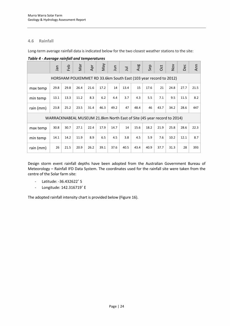
Long-term average rainfall data is indicated below for the two closest weather stations to the site:
Table 4 - Average rainfall and temperatures
Jan
Feb
Mar
Ap
r
May
Jun
Jul
Au
g
Sep
Oct
No
v
Dec
An
n
HORSHAM POLKEMMET RD 33.6km South East (103 year record to 2012)
max temp 29.8 29.8 26.4 21.6 17.2 14 13.4 15 17.6 21 24.8 27.7 21.5
min temp 13.1 13.3 11.2 8.3 6.2 4.4 3.7 4.3 5.5 7.1 9.5 11.5 8.2
rain (mm) 23.8 25.2 23.5 31.4 46.3 49.2 47 48.4 46 43.7 34.2 28.6 447
WARRACKNABEAL MUSEUM 21.8km North East of Site (45 year record to 2014)
max temp 30.8 30.7 27.1 22.4 17.9 14.7 14 15.6 18.2 21.9 25.8 28.6 22.3
min temp 14.1 14.2 11.9 8.9 6.5 4.5 3.8 4.5 5.9 7.6 10.2 12.1 8.7
rain (mm) 26 21.5 20.9 26.2 39.1 37.6 40.5 43.4 40.9 37.7 31.3 28 393
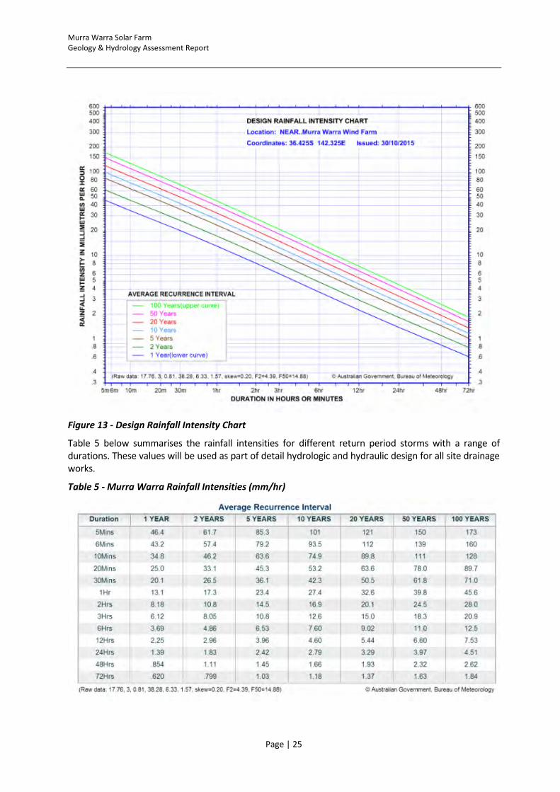
Design storm event rainfall depths have been adopted from the Australian Government Bureau of Meteorology – Rainfall IFD Data System. The coordinates used for the rainfall site were taken from the centre of the Solar farm site:
- Latitude: -36.432622˚ S
- Longitude: 142.316719˚ E
The adopted rainfall intensity chart is provided below (Figure 16).
Murra Warra Solar Farm Geology & Hydrology Assessment Report
Page | 25
Figure 13 - Design Rainfall Intensity Chart
Table 5 below summarises the rainfall intensities for different return period storms with a range of durations. These values will be used as part of detail hydrologic and hydraulic design for all site drainage works.
Table 5 - Murra Warra Rainfall Intensities (mm/hr)
Murra Warra Solar Farm Geology & Hydrology Assessment Report
Page | 26
4.7 Site Drainage
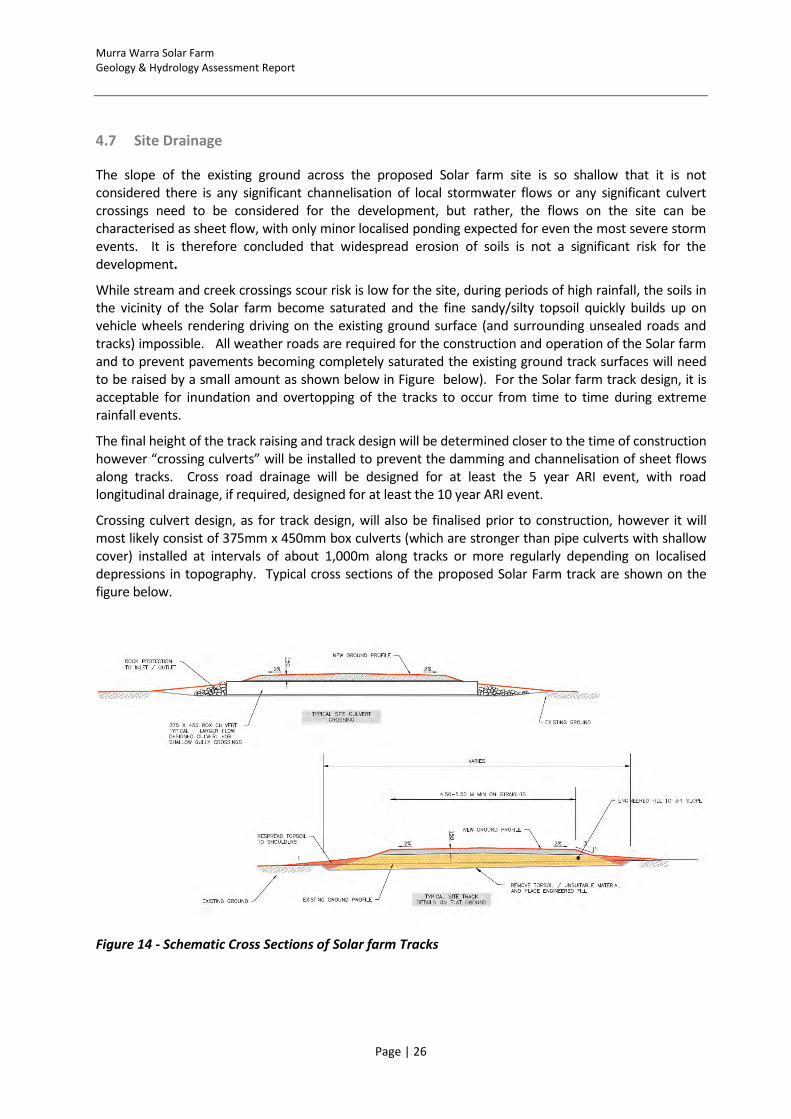
The slope of the existing ground across the proposed Solar farm site is so shallow that it is not considered there is any significant channelisation of local stormwater flows or any significant culvert crossings need to be considered for the development, but rather, the flows on the site can be characterised as sheet flow, with only minor localised ponding expected for even the most severe storm events. It is therefore concluded that widespread erosion of soils is not a significant risk for the development.
While stream and creek crossings scour risk is low for the site, during periods of high rainfall, the soils in the vicinity of the Solar farm become saturated and the fine sandy/silty topsoil quickly builds up on vehicle wheels rendering driving on the existing ground surface (and surrounding unsealed roads and tracks) impossible. All weather roads are required for the construction and operation of the Solar farm and to prevent pavements becoming completely saturated the existing ground track surfaces will need to be raised by a small amount as shown below in Figure below). For the Solar farm track design, it is acceptable for inundation and overtopping of the tracks to occur from time to time during extreme rainfall events.
The final height of the track raising and track design will be determined closer to the time of construction however “crossing culverts” will be installed to prevent the damming and channelisation of sheet flows along tracks. Cross road drainage will be designed for at least the 5 year ARI event, with road longitudinal drainage, if required, designed for at least the 10 year ARI event.
Crossing culvert design, as for track design, will also be finalised prior to construction, however it will most likely consist of 375mm x 450mm box culverts (which are stronger than pipe culverts with shallow cover) installed at intervals of about 1,000m along tracks or more regularly depending on localised depressions in topography. Typical cross sections of the proposed Solar Farm track are shown on the figure below.
Figure 14 - Schematic Cross Sections of Solar farm Tracks
Murra Warra Solar Farm Geology & Hydrology Assessment Report
Page | 27
5 DESIGN CONSIDERATION
5.1 Access Tracks and Hard Standings
Appropriate design, construction and maintenance of these access tracks will ensure that any effects upon soils and water flows can be minimised.
The key point in minimising the impact of roads is to reduce the accumulation and channelling of water by dispersing it back into the usual catchment system.
5.2 Racking Foundations
Foundations for the mounting racks will generally be installed across the flat terrain with no modification of the natural topography.
The proposed layout of the Solar farm has also taken into account of the following considerations:
Avoidance of existing trees and vegetation;
Avoidance of natural low-points which could disrupt natural water flow and/or drainage during wet periods.
Murra Warra Solar Farm Geology & Hydrology Assessment Report
Page | 28
6 CONSTRUCTION MITIGATION MEASURES
Control of erosion and potential sedimentation of waterways is a primary area of concern for works on-site. The design of the Solar farm access tracks shall be undertaken with consideration of the sedimentation and erosion risks in accordance with the EPA document Construction Techniques for Sediment Pollution Control9.
An assessment of the soil acidity will be undertaken prior to construction works commencement of construction.
Mitigation strategies that would be employed during the construction phase to manage the potential for adverse environmental impacts as outlined below.
6.1 Access Tracks and Hard Standings
Continual maintenance of drainage system and track and hard standing surfaces during construction;
Site preparation works and major earthwork activity will be planned to occur during drier months. Where this is not possible, earthwork activity will be avoided during heavy rain events;
Dust suppression regime for all roads and hard standings to be in place for the entire
construction period including:
o The amount of exposed earth left as a result of clearing (for site preparation) at any one time should be kept to a minimum;
o All stockpiles to avoid loss of material during high Solar events, and where practicable will be placed in areas sheltered from the Solar. Where significant amounts of material are lost, a review of storage procedures should be undertaken to avoid recurrence of the event; and
o Where vegetation is impacted by excessive dust emissions, remedial action is to be implemented, which may include revegetation of affected species;
Stabilisation and rehabilitation of disturbed surfaces as soon as practicable after works; and
Installation of erosion and sediment controls identified in the Soil and Water Management plan to be developed for the site (at the post-consent EMP stage).
9 EPA Victoria, May 1991. Construction Techniques for Sediment Polluton Control
Murra Warra Solar Farm Geology & Hydrology Assessment Report
Page | 29
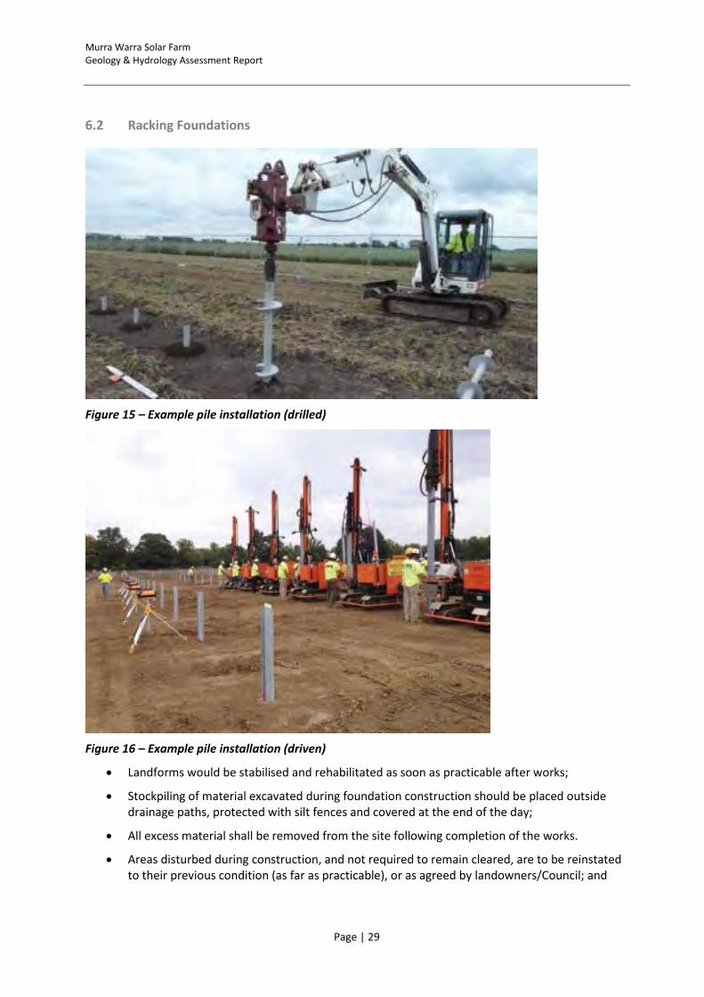
6.2 Racking Foundations
Figure 15 – Example pile installation (drilled)
Figure 16 – Example pile installation (driven)
Landforms would be stabilised and rehabilitated as soon as practicable after works;
Stockpiling of material excavated during foundation construction should be placed outside drainage paths, protected with silt fences and covered at the end of the day;
All excess material shall be removed from the site following completion of the works.
Areas disturbed during construction, and not required to remain cleared, are to be reinstated to their previous condition (as far as practicable), or as agreed by landowners/Council; and

Murra Warra Solar Farm Geology & Hydrology Assessment Report
Page | 30
Potential surface water contamination is perceived to increase when temporary concrete batching plant/s are proposed for use during construction. Careful consideration of the placement and management practices of any temporary concrete batching plant/s will need to occur; and suitable bunding arrangements adopted to prevent contamination of the surrounding soils.
There is a risk of contamination to soils as a result of hydrocarbon infiltration and on-site toilet facilities. The following mitigation measures should be considered during construction:
allowance for bunded site storage areas for potential contaminants would be identified;
storage of hydrocarbon spill kits on-site;
operation and maintenance of machinery in a manner that minimises risk of hydrocarbon spill;
concrete wash would be deposited in an excavated area, below the level of the topsoil; and
minimise risk of chemical spills and ensure prompt and effective clean-up of any accidental spills.
Ensure appropriate disposal of effluent from onsite staff facilities
Murra Warra Solar Farm Geology & Hydrology Assessment Report
Page | 31
7 OPERATIONAL MITIGATION MEASURES
The operational phase of the Solar farm will require minimal use of on-site access tracks by maintenance personnel. The main external access tracks will be constructed to accommodate oversize and over mass loads. Once the Solar farm is constructed, the external access tracks would be available for use by the landowners to provide access throughout their properties. No soil or landform impacts are anticipated to be generated during the operational phase given the following recommended measures to restrict runoff and thus limiting off-site impacts:
Development and instigation of a Soil and Water Management Plan;
Monitoring of maintenance of drainage systems and sediment control devices and maintain as required;
Construction mitigation measures listed above are instigated if sizable maintenance works are required; and
All vehicles on-site shall follow established tracks.
Murra Warra Solar Farm Geology & Hydrology Assessment Report
Page | 32
8 FURTHER INVESTIGATIONS
The findings above are based on a combination of a desktop study of the information available at the
time of the assessment, as listed above, a site reconnaissance by RES’ Civil Engineer and Construction
Manager and preliminary geological mapping and test pitting of selected sites. It is recommended that
further studies and investigations are undertaken post-consent to identify issues and appropriate
mitigation measures. These include:
Development of a detailed Soil and Water Management Plan, to be included in a future Environmental Management Plan (EMP);
Potential occurrence of Acid Sulphate Soils (ASS)
Detailed design of the site drainage system; and
Intrusive geotechnical investigations be carried out prior to construction works commencing on-site to confirm the information gathered, to identify soils of erosion or dispersion risk and enable safe and efficient design of turbine foundations, tracks, hard standings and site buildings.
Murra Warra Solar Farm Geology & Hydrology Assessment Report
Page | 33
9 CONCLUSIONS
The site investigations carried out to date for the proposed Solar farm development have comprised a desktop study and a number of site inspections and assessments.
The proposed Murra Warra Solar farm is located approximately 32 km northeast of Horsham, immediately south of the section of Minyip-Dimboola Road that runs between the Blue Ribbon Road and the Henty Highway. The site has a total development area of approximately 370 hectares and is located adjacent to the proposed Murra Warra Solar farm site (with a total area of 4,200 hectares). The proposed site is currently utilised for broad acre cropping.
Based on the information available at the time of writing the report the following conclusions and recommendations are made:
Construction of the proposed Solar farm has, given the very flat nature of the site, minimal potential to affect or modify existing surface drainage pathways, cause erosion, sedimentation, or generate turbid run-off. Any impacts during construction and over the long term can either be eliminated or mitigated by adopting appropriate design practices and careful construction techniques.
Provided that the principles above are implemented any effects of construction on the groundwater table are likely to be negligible in the short and long term. There is currently very little existing beneficial use of the existing saline water table by local landowners. The groundwater table is approximately 30m below the existing ground level. No construction excavations (including proposed quarry sites) will intercept the ground water table.
There are no waterways of significance within the site area and the obsolete irrigation channels (since replaced by a piped rural water supply system) are not required for local storm water management with many of them already having been filled in. Through careful management during construction, any minor impacts to surface water can be avoided.
Potential surface water contamination is perceived to increase when temporary concrete batching plant/s are proposed for use during construction. Careful consideration of the placement and management practices of any temporary concrete batching plant/s will need to occur.
No water quality impacts are anticipated to be generated during the operational phase due to the minimal use of tracks during operation of the Solar farm.
RES intends to develop a quarry which has been proposed for the wind farm project to reduce the number of road construction deliveries required for construction and will seek an amendment to the endorsed work plan to allow for extraction of material to also supply the solar development. The current volume of the quarry as shown in the work plan should be able to satisfy the requirements of both projects. Preliminary site investigations and testing indicate that the material will be suitable for the construction of tracks and hardstands.
Therefore, based on an assessment of the subject site’s geology and hydrology features, it is considered that the granting of consent for the development of a proposed Solar farm project would not be considered likely to result in any significant adverse impact upon the soil and water features of the subject site and surrounding area and the proposal would be capable of complying with relevantly applicable legislation and guidelines.

Murra Warra Solar Farm Geology & Hydrology Assessment Report
Page | 34
APPENDIX A - DRAWINGS
Drawing 1: Murra Warra Solar farm Location Plan
Drawing 2: Murra Warra Solar Farm Site Topography and Drainage
Drawing 3: Murra Warra Solar Farm Regional Hydrology
Drawing 4: Murra Warra Solar Farm Planning Layout
Drawing 5: Murra Warra Solar farm Solar Grid Corridor Battery Storage & Collector Station

Murra Warra Solar Farm Geology & Hydrology Assessment Report
Page | 35
APPENDIX B – GEOLOGICAL MAPS

Murra Warra Solar Farm Geology & Hydrology Assessment Report
Page | 36
APPENDIX C – BOREHOLE LOGS

Murra Warra Solar Farm Geology & Hydrology Assessment Report
Page | 37
APPENDIX D – FLOOD MAPS

Murra Warra Solar Farm Geology & Hydrology Assessment Report
Page | 38
appendix E – Wimmera Malle Pipeline Project - As Constructed

Murra Warra Solar Farm Geology & Hydrology Assessment Report
Page | 39