aran annual report - water.usgs.gov · determine the optimal shade for production of anthurium and...
TRANSCRIPT

Virgin Islands Water Resources Research Institute Annual Technical Report
FY 2006

IntroductionThe Water Resources Research Institute is the only unit of its kind in the U. S. Virgin Islands. TheVI-WRRI has as its primary mission the conduct of research, training and information dissemination withpriority placed on those activities that are of significance to insular tropical settings and that meet currentneeds of the Virgin Islands community. The program executed by the VI-WRRI in the 2006-2007 programyear addressed agricultural production in water scare conditions and the impact of development of surfacewater runoff on fauna diversity in hillside guts and on coastal water quality. This program addressedpriority areas identified by the VI-WRRI’s Advisory Board.
The VI-WRRI having the concerns of the community it serves as a primary focus is consistent with that ofits host university, the University of the Virgin Islands (UVI). UVI, with campuses on the islands of St.Croix and St. Thomas and a research station on St. John, is committed to providing excellent teaching,innovative research and responsive community service to the people of the U. S. Virgin Islands and thewider Caribbean. In the tradition of other land-grant institutions, UVI has pledged itself to enhancing thesocial and economic transformation of the U. S. Virgin Islands. The Water Resources Research Instituteand other programs at UVI all work in support of these commitments and the proposed WRRI program for2006-2007 reflects this.

Research ProgramThe research program of the Virgin Islands Water Resources Research Institute for the 2006 - 2007program year consisted of four projects. Two of these projects were completed and two will be continuedduring the next year. The projects all focused on areas with high levels of concern in the Virgin Islands -the impact of watershed activities on coastal water quality and optimal use of available fresh watersupplies.
Through this year’s WRRI research program, the first epidemiological study of its kind in the Caribbeanarea was conducted and the first documentation of the occurrence of several species in the Virgin Islandsmight have been conducted. Students played an active role in the research conducted resulting in theresearch activities also serving a valuable training function.
Development of a water budget for shade-house crops in the U.S.Virgin Islands
Basic Information
Title: Development of a water budget for shade-house crops in the U.S. Virgin Islands
Project Number: 2006VI64B
Start Date: 3/1/2006
End Date: 2/28/2007
Funding Source: 104B
Congressional District: VI
Research Category: Biological Sciences
Focus Category: Agriculture, Water Use, Water Supply
Descriptors: None
Principal Investigators: Ramon Arancibia, Donald Bailey

Publication1. None as yet.

Problem and Research Objectives In spite of the favorable conditions to grow horticultural crops throughout the year in the U.S. Virgin Islands (USVI), production is restricted because of water deficit. Rainfall is insufficient to maintain adequate soil moisture levels for crop production particularly during the dry season (December to August). Consequently, crops experience water stress and irrigation needs to be ensured to obtain acceptable yields. Existing ponds and dams in the USVI are insufficient to store water for agricultural purposes and the low quality of underground water restricts production of many horticultural crops. Desalinized sea-water is being use widely for domestic consumption, but is too expensive for agricultural purposes. Rainwater catchments have long been used in the USVI for domestic consumption and appear to be a feasible supply of good quality water for high value horticultural crops. Adoption of ground liners as a rainwater catchments system has been difficult because it requires additional land that is lost for production and the system has been focused to irrigate crops under full sun that require high amount of water. The water deficit in the USVI horticultural industry can be ameliorated by growing crops under shade since plants require substantially less irrigation water. Crops grown in open fields of a semi-dry tropical climate are subjected to direct sunlight, high temperatures and wind resulting in high crop evapo-transpiration (ETc) and therefore, demanding large amounts of water. In contrast, shade-houses favor plant growth since plants are less stressful: direct sunlight is avoided, temperature is lower, humidity is higher, wind is reduced, and ETc is low. Irrigation water requirement of 23% to 31% pan evaporation has been used for leatherleaf fern grown under 70% light reduction (Stamps, 1995). In addition, water use efficiency increases under shady conditions (Durr and Rangel, 2003; Jifon and Syvertsen, 2003). Excessive shade, however, can be detrimental for crop production because of reduced photosynthesis. This suggests that the USVI horticultural industry may benefit tremendously by the incorporation of shade-houses for a water-sustainable production system. In addition, some high value ornamentals perform better when grown under shady conditions and there is a demand to complement the flourishing tourist industry in the USVI. This study evaluated water requirements to produce anthurium cut flowers and heliconias under shade conditions in the USVI. The specific objectives of this study are: a) to determine the water use efficiency in crops grown under shade conditions, and b) to determine the optimal shade for production of anthurium and heliconias. Crops were grown in a shade-house with three different shade levels and the irrigation water balance was analyzed and compared with meteorological data. The information obtained in this project will help horticulturists in the USVI develop decision criteria for crop selection and adoption of shade-houses to improve water productivity (WP). Methodology and Principal Findings All experiments were conducted at the University of the Virgin Islands Agricultural Experiment Station in St. Croix, VI.

Experiment I
Methodology: In the first experiment, three water stress levels and two shade levels were studied for Anthurium cut flower production. Irrigation schedule was based on soil moisture levels at -10, -30, and -50 kPa to determine the effect of water stress on water savings and flower production and quality. The shade levels were 60% and 80%. Eight plants were planted on 1.44 m2 beds filled with a base of 20 cm sand topped with another 20 cm soilless media (Promix BX). Three plots (repetitions) were set up for each treatment. Plots were irrigated with micro-sprinklers scheduled to irrigate when soil moisture reached the corresponding treatment level. Soil moisture was monitored by Watermark soil moisture sensors (Irrometer Co., Riverside, CA) and connected to the Watermark Electronic Module (Irrometer Co.) which would allow the solenoid to open for irrigation. Soil moisture, applied water quantity, pan-evaporation, and flower production were monitored from January to April, 2006 to determine water requirements. Rainfall and pan-evaporation from the meteorological station was monitored also. Due to the inconsistency of the Watermark sensor at stressing levels and the low quality of the flowers, the irrigation schedule was changed in May to daily irrigation with fixed amount of water. Treatment consisted in 1.1, 2.2 and 3.3 mm a day for both shade levels. These amounts were approximately 16%, 33% and 50% pan evaporation at full sun. In addition, 2.2 and 3.3 mm correspond to 1.2 times pan evaporation at 80% and 60% shade, respectively. Principal Findings: Rainfall was substantially lower than evapo-transpiration particularly during the dry season (January to August) (table 1, fig 1). By the end of April when irrigation scheduling was changed, pan evaporation at 60% and 80% shade was reduced to 47% and 32% of full sun pan-evaporation, respectively, and rainfall was 21% (79% deficit). Similar differences in pan evaporation continued until the end of the experiments in November, however, rainfall deficit was reduced to 53% since the rain was more frequent and heavier. These results suggest that shading is an excellent alternative to reduce crop water requirements in comparison to direct sun production and that it is possible to grow crops in a shade-house modified to catch rainwater and use it for irrigation. In the first period, the automatic irrigation system worked well at -10 kPa allowing irrigation to start. The amount of water applied to the -10kPa treatment at 60% and 80% shade was 66 mm in 4 applications and 33 mm in 2 applications, respectively. In contrast, at lower soil moisture levels the moisture sensors appeared to have lost contact with the media and reading became erratic. In this production period, the number of harvested flowers was slightly lower at 80% shade (fig 2), but flower quality appeared to be superior. In addition, water stress with the purpose of saving water was detrimental on flower production since the number of flowers (and quality) was dramatically reduced (fig 2). In the second production period, there was no difference in production between the amounts of applied water at 80% shade (fig 3). Yield of flowers was higher at 60% than at 80% shade suggesting that 80% shade may have been below the optimum and photosynthesis may have been reduced. Within 60% shade yield was reduced with lower amount of

water suggesting that irrigation may have been suboptimal. Therefore, evapotranspiration needs to be satisfied in full for optimum production.
Experiment II
Methodology: A second experiment was conducted in September – November, 2006 to estimate water requirements and water use efficiency in production of potted anthurium and heliconia under three shade conditions. A greenhouse 20' by 12' was built and separated in four sections with shade levels of 0%, 30%, 50% and 70% (DeWitt Knitted shade cloth, Hummert International, Earth City, MO). Six anthuriums and three heliconias growing in three-gallon black pots were used per treatment. Rainwater collected from the greenhouse’s top through gutters was stored and used for drip-irrigation and plants were fertilized by injecting soluble fertilizer (Peters 20-20-20 + micronutrients at 100ppm N). An automatic irrigation systems based on a timer was set up to irrigate pots for 1 min three times a day. Drippers of 2, 1, 0.5, and 0.5gal.h-1 were used for 0%, 30%, 50% and 70% shade, respectively. Excess drain water was monitored daily to determine daily water used and pot weigh was monitored once a month. Pan evaporation was monitored at each shade level for comparison with rainfall and pan evaporation from the meteorological station. Temperature, relative humidity and solar radiation were monitored also with a Watchdog mini-datalogger (Spectrum Technologies, Inc., East Plainfield, IL). Principal Findings: Water requirements of potted anthurium and heliconia were reduced significantly as shade level was increased from section 1 (no shade) to section 4 (70% shade) (table 2). Similar to pan-evaporation, daily water used by both anthuriums and heliconias was reduced to 21% and 18%, respectively, from no shade to 70% shade. This reduction appears to be the effect of less solar radiation since temperature and relative humidity were similar among the shade levels. Pan evaporation recorded at the shade-house including the non-shaded treatment was lower than pan evaporation at the weather station. 55% reduction in section 1 which was not shaded may have been due to the reduced solar radiation under the plastic top and the more protected conditions that may have reduced the wind effect. Growth of the potted plants was not detected in the shaded treatments. Both anthurium and heliconias did not survive the non-shaded treatment and plants turned yellow and 60 % died during the trial. Three month trial appears to be insufficient to evaluate growth of tropical ornamental under shade conditions. Therefore, a longer testing period is needed to determine water productivity for these crop species.
Conclusions It may be concluded then that:
• Catching rainwater in a modified shade-house and use it for irrigation may be

sufficient to implement a water sustainable production system. • Increasing shade level reduces water requirements for Anthurium and heliconia
production and yield. Anthurium and heliconia are recommended to be grown under 50% - 70% shade to improve growth and the flower quality.
• Stressing plants to save water is not recommended due to reduction of flower production and quality.
SIGNIFICANCE Development of a water sustainable production system will impact favorably the horticulture industry since water is the most limiting constraint to agriculture in the USVI. Water deficit ranges between 40% and 70% during the dry season in the territory. Production of shade loving crops appears to be an excellent alternative to reduce water requirement and improve water use efficiency and productivity in the USVI. In addition, collection and storage of rainwater will reduce the dependency on costly city water. Rain-water collection and storage has being long adopted in the USVI for household consumption and can be easily adopted to develop a water sustainable production system. Adoption of this system by small-scale growers may increase production of ornamental and specialty crops in the USVI impacting tremendously the local economy.
Table 1
Total Evaporation and Rainfall, St Croix, USVI. January-November, 2006
Percent from pan evaporation
Cumulative Pan evaporation Rainfall Evap I Evap II
Rainfall Evap I Evap II Shade (Weather station) 80% 60% 80% 60% mm mm mm mm % % % April, 2006 629 135 203 297 21 32 47 Nov, 2006 1824 970 516 862 53 28 47

0200400600800
100012001400160018002000
1/13
2/12
3/14
4/13
5/13
6/12
7/12
8/11
9/10
10/10 11
/9
Date
Cum
mul
ativ
e ra
infa
ll/ev
apor
atio
n (m
m) Rain
EvpEvap 60% shadeEvap 80% shade
Figure 1
Cumulative Rainfall and Pan-evaporation at Full Sun, 60% and 80% Shade. January – November, 2006, Kingshill, St. Croix, USVI.
1030
50 8060
0
2
4
6
8
10
Flow
ers
(no/
m2 )
Soil moisture (kPa) Shade (%)
8060
Figure 2. Anthurium production at three irrigation regimes (-10, -30 and -50 kPa) under 60% and 80% shade. Harvest from January to April, 2006. Production plots were 1.44 m2.

1.12.2
3.3 8060
0
5
10
15
20
25Fl
ower
s (n
o/m
2 )
Irrigation (mm/day) Shade (%)
8060
Figure 3. Anthurium production at three irrigation regimes (1.1, 2.2 and 3.3 mm/day) under 60% and 80% shade. Harvest from May to November, 2006. Production plots were 1.44 m2.
Table 2
Pan-evaporation, water used, temperature (temp), relative humidity (RH), and solar radiation (SRD) in shade-house production of potted anthuriums and heliconias
Daily pan- Daily water used / plant evaporation Anthurium Heliconia temp RH SRD mm mL mL C % MJ/m2/day
Weather station 5.8 0% shade 3.2 297a 265 a 28.2 77 14.6
30% shade 2.3 150 b 124 b 28.1 78 8.1 50% shade 2.0 75 c 68 c 28.1 78 6.3 70% shade 1.4 62 c 48 c 27.7 81 3.8

Impervious Surface Analysis of Terrestrial Watersheds of theU.S. Virgin Islands with Application to the East End MarinePark, St. Croix
Basic Information
Title: Impervious Surface Analysis of Terrestrial Watersheds of the U.S. Virgin Islandswith Application to the East End Marine Park, St. Croix
Project Number: 2006VI67B
Start Date: 3/1/2006
End Date: 8/31/2007
Funding Source: 104B
Congressional District: N/A
Research Category: Water Quality
Focus Category: Non Point Pollution, Water Quality, Methods
Descriptors:
Principal Investigators: Colin Finney, Denise Rennis, Henry H. Smith

Publication1. None as yet.

Problem and Research Objectives In the U.S. Virgin Islands, housing, roads, and commercial and industrial development are increasingly replacing natural terrestrial environments such as grasslands and forests. Increased sediment loading and nutrient enrichment from development activities in upland watersheds often results in degradation of inshore marine communities, particularly coral reefs and seagrass beds, which require clear water and high light levels to persist. Rogers (1990) has suggested that the primary cause of coral reef degradation in coastal areas of the U.S. Virgin Islands is development activities, especially land disturbances and dredging. The natural landscape typically is made up of pervious surfaces - areas vegetated with trees, shrubs, and grasses - which under normal conditions allow precipitation to infiltrate the soil. One of the principal effects of development and urbanization is the conversion of pervious surfaces into impervious surfaces - man-made surfaces that inhibit the infiltration of water into the soil. This is complicated on the US Virgin Islands by the diversion of rainwater from roofs into private cisterns which limits run-off.
Research over the past two decades has indicated that increased quantities of impervious surfaces are closely associated with environmental degradation, specifically that the quantity of impervious surfaces in a watershed is inversely correlated with the health of that watershed and the health of waterbodies, such as coastal environments, that receive discharges from that watershed (Center for Watershed Protection, 2003). On St. John, for instance, MacDonald et al. (1997) demonstrated that unpaved roads may contribute the majority of sediment to marine ecosystems. The goal of the proposed study is to use impervious surface analysis as a methodology for effectively monitoring and managing water quality and habitat health of a watershed and to apply this as a case study to one or more of the watersheds on St. John where non-point source pollution from incompatible upland development has been identified as a major threat. To attain this goal, it will be necessary to accurately map terrestrial impervious surfaces at a watershed scale. The objectives of the proposed study will be to: 1. Establish land-use categories and evaluate infiltration coefficients that are consistent with the
U.S. Virgin Islands landscape and currently used land-use categories; 2. Establish baseline and current impervious surface cover datasets within one or more
terrestrial watersheds on St. John using remote sensing; 3. Execute a change analysis of impervious surfaces using remote sensing information and
classification mapping; 4. Document a protocol for monitoring changes of impervious surfaces, based on one or more of
the terrestrial watersheds on St. John, to enable land managers to assess land-use changes and focus on different landscape levels for protection and/or restoration;
5. Provide an educational brochure for minimizing impacts due to impervious surfaces which
could be disseminated to private landowners and other members of the community through the Cooperative Extension Services of the University of the Virgin Islands.
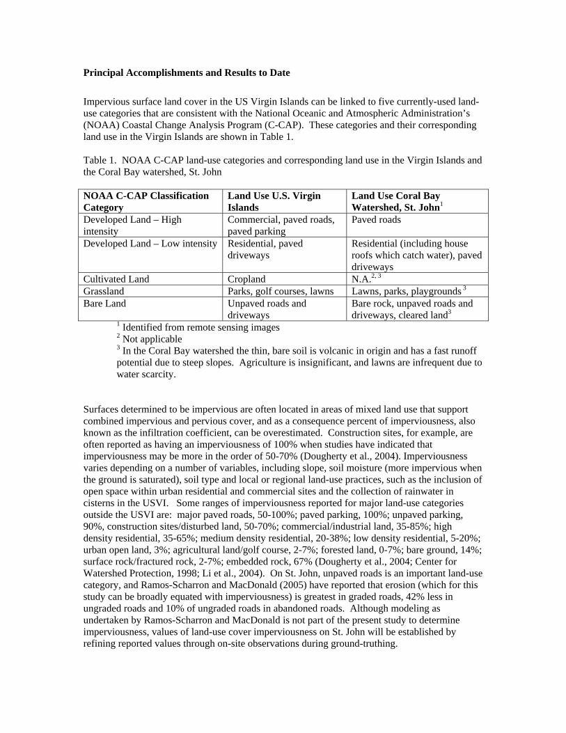
Principal Accomplishments and Results to Date
Impervious surface land cover in the US Virgin Islands can be linked to five currently-used land-use categories that are consistent with the National Oceanic and Atmospheric Administration’s (NOAA) Coastal Change Analysis Program (C-CAP). These categories and their corresponding land use in the Virgin Islands are shown in Table 1. Table 1. NOAA C-CAP land-use categories and corresponding land use in the Virgin Islands and the Coral Bay watershed, St. John NOAA C-CAP Classification Category
Land Use U.S. Virgin Islands
Land Use Coral Bay Watershed, St. John1
Developed Land – High intensity
Commercial, paved roads, paved parking
Paved roads
Developed Land – Low intensity Residential, paved driveways
Residential (including house roofs which catch water), paved driveways
Cultivated Land Cropland N.A.2, 3 Grassland Parks, golf courses, lawns Lawns, parks, playgrounds 3 Bare Land Unpaved roads and
driveways Bare rock, unpaved roads and driveways, cleared land3
1 Identified from remote sensing images 2 Not applicable 3 In the Coral Bay watershed the thin, bare soil is volcanic in origin and has a fast runoff potential due to steep slopes. Agriculture is insignificant, and lawns are infrequent due to water scarcity.
Surfaces determined to be impervious are often located in areas of mixed land use that support combined impervious and pervious cover, and as a consequence percent of imperviousness, also known as the infiltration coefficient, can be overestimated. Construction sites, for example, are often reported as having an imperviousness of 100% when studies have indicated that imperviousness may be more in the order of 50-70% (Dougherty et al., 2004). Imperviousness varies depending on a number of variables, including slope, soil moisture (more impervious when the ground is saturated), soil type and local or regional land-use practices, such as the inclusion of open space within urban residential and commercial sites and the collection of rainwater in cisterns in the USVI. Some ranges of imperviousness reported for major land-use categories outside the USVI are: major paved roads, 50-100%; paved parking, 100%; unpaved parking, 90%, construction sites/disturbed land, 50-70%; commercial/industrial land, 35-85%; high density residential, 35-65%; medium density residential, 20-38%; low density residential, 5-20%; urban open land, 3%; agricultural land/golf course, 2-7%; forested land, 0-7%; bare ground, 14%; surface rock/fractured rock, 2-7%; embedded rock, 67% (Dougherty et al., 2004; Center for Watershed Protection, 1998; Li et al., 2004). On St. John, unpaved roads is an important land-use category, and Ramos-Scharron and MacDonald (2005) have reported that erosion (which for this study can be broadly equated with imperviousness) is greatest in graded roads, 42% less in ungraded roads and 10% of ungraded roads in abandoned roads. Although modeling as undertaken by Ramos-Scharron and MacDonald is not part of the present study to determine imperviousness, values of land-use cover imperviousness on St. John will be established by refining reported values through on-site observations during ground-truthing.

In order to develop our methodology for this study, the study data components and the principal impervious surface categories were assessed in ERDAS Imagine 8.7. The initial data components consisted of:
• Cloud free IKONOS satellite imagery from late 2005 and early 2006 courtesy of NOAA; • Overlays of watershed boundaries, shoreline, and roads; • High resolution aerial photographs from 1994 (1 ft), courtesy of the US Army Corps of
Engineers (USACE) and September 2004, courtesy of the Natural Resources Conservation Service (NRCS) and the USACE.
Both remote sensing imagery sets were found to have advantages and disadvantages. The aerial photography imagery from September 2004 was our initial target imagery as it was both high quality and high resolution. Because it is generally limited to three color bands, or may only have one band (black and white), aerial photography imagery is very restricted in the digital image processing that can be used. For instance, unless the color bands include a near infra-red band, the generation of standardized vegetation indices, such as discussed below, is not possible. The color bands available from the NRCS/USACE 2004 aerial photography were the traditional red, green and blue bands. The other major disadvantage of aerial photographic imagery is that it is expensive and generally commissioned at infrequent intervals. Aerial photography in the USVI generally is commissioned by federal agencies, such as the USACE, and is dependent on departmental budgets of the USACE as well as collaborating agencies such as the NRCS. This makes it difficult to predict future availability of imagery sets for comparative purposes. IKONOS satellite imagery from late 2005 and early 2006, purchased by NOAA, became available during the project. One advantage of the satellite imagery is that equivalent imagery should be available in the future allowing comparisons to be made between data sets. The future cost of these data sets is unknown, but they will be substantially less than commissioned aerial photography, and it is quite possible, as with the 2005-2006 IKONOS imagery used in this study, that they may be available at no cost. Additionally, IKONOS satellite imagery produces four bands (red, green, blue, near-IR, 4 meter resolution) as well as a panchromatic (1 meter resolution). As noted above, sufficient bands allow digital imaging techniques to be utilized. The use of the near-IR band in the IKONOS data allows Normalized Difference Vegetation Index (NVDI) to be readily calculated. Forested / vegetated areas on St John should be discriminated through the use of the NDVI (NDVI = near IR band - red band) / (near IR band + red band), however a sharp distinction was not found, possibly because the vegetation seems to reflect a high amount of light in the intense tropical sunlight. Further analysis of the IKONOS image showed that impervious surfaces are bright and vegetation is dark. The blue band of IKONOS provided the cleanest distinction between vegetation and impervious surfaces. The IKONOS pan reinforced the blue band but had much more variation due to its panchromatic spectral responsivity. Techniques to separate paved roads from unpaved roads were also evaluated. While the discrimination between tarmac roads and other types of roads appears to be relatively easily done, discrimination amongst concrete roads, other man-made surfaces and rock outcrops, based on their spectral signatures, has not been accomplished. Further work on refining the spectral signatures will be necessary to achieve this.

A brochure to educate homeowners on simple actions that can be taken to minimize the effects of impervious surfaces has been drafted. Information provided in the brochure includes a simple explanation of what impervious surfaces are and the effects these have on the environment. The brochure briefly describes the project and highlights the main actions that homeowners can take to minimize the impacts from impervious surfaces.
Diversity of freshwater fish and invertebrates of St. Thomaswatersheds and its relationship to water quality as affected byresidential and commercial development
Basic Information
Title:Diversity of freshwater fish and invertebrates of St. Thomas watersheds and itsrelationship to water quality as affected by residential and commercial development
Project Number: 2006VI73B
Start Date: 3/1/2006
End Date: 7/30/2007
Funding Source: 104B
Congressional District: USVI
Research Category: Biological Sciences
Focus Category: Ecology, Water Quality, Education
Descriptors:
Principal Investigators: Donna Nemeth

Publication1. None as yet.

Problem and Research Objectives Despite extensive current work surveying, characterizing, and mapping the watersheds and riparian vegetation of the Virgin Islands (IRF, CDC, and DPNR 2004), the aquatic portion of that freshwater and brackish habitat remains poorly surveyed. Even with the detailed GIS maps produced in the IRF et al. Final Report (2004), the principal investigators acknowledge that they are unable to resolve on the maps which watersheds contain permanent pools or continually flowing streams (B. Devine, pers. comm.). St. Thomas has limited freshwater resources, represented by a small number of guts that drain the island’s 13 watersheds (identified by IRF et al. 2004). The majority of these guts carry water only seasonally, and flows vary dramatically with changing rainfall. Despite the often temporary nature of the freshwater habitat, several species of fishes and shrimps persist in these guts. In addition, the introduction of Tilapia to the Virgin Islands for aquaculture has resulted in the release of these African fishes into local freshwater habitats. The effect of this introduction on Virgin Islands wildlife remains unexplored. From a management perspective, these freshwater habitats form a vital connection between terrestrial activities and the marine habitat downstream. The discharge of fresh water into the sea also creates a brackish habitat (e.g. mangrove swamps and salt ponds) used by many commercially and recreationally important marine fish species as a nursery. The current research emphasis in the Virgin Islands on the problems of non-point source pollution and the sedimentation from terrestrial erosion affecting the coral reef and other marine organisms has largely ignored the watershed habitat through which these pollutants are transported. With no record of faunal diversity of this fragile and ephemeral aquatic habitat, there exists no baseline for evaluating the potential effects of current and future land-use practices. The brackish environment created where the guts enter the sea also provides an important nursery habitat for juvenile mullet, snook and tarpon. In addition, while territorial conferences on non-point source pollution as well as numerous marine outreach programs on the fragility of the marine environment have sought to educate schoolchildren and the voting populous, the more cryptic freshwater gut environments are largely unappreciated for their ecological value and their sensitivity to anthropogenic factors. There is a great need for public education, including lawmakers, to ensure that development and zoning can proceed in an environmentally-agreeable manner. The freshwater guts represent an important cultural and ecological resource in the Virgin Islands. Interviews conducted by Toni Thomas from UVI’s Cooperative Extension Service elucidate the recreational value of the guts in the form of hiking, a peaceful retreat, and a place for families to gather. Historically, islanders report gathering at deep gut pools with their families for an afternoon of bathing and collecting eels (Anguilla rostrata),

‘langoustas’ (Macrobrachium sp.), and ‘cocouey’ (small penaeaid shrimps) to cook right on the shores of the stream. These organisms may also mitigate the effects of high nutrient input and sedimentation associated with human development. Filter-feeding omnivorous shrimps (Atya sp.) found in the St. Thomas guts have been shown to play an important role in processing and reducing the fine benthic particulate organic matter in stream environments as well as the suspended organic material and sediments (Pringle et al., 1999). Tadpoles, also abundant in St. Thomas watersheds (Leptodactylus albilabris and Osteopilus; pers. obs.), have the potential to influence total sediments and organic components of tropical streams (Ranvestel, et al. 2004). Despite an annual rainfall average of 96 cm (Southeast Regional Climate Center), St. Thomas has very limited freshwater resources. Steep island slopes have resulted in the formation of guts, or waterways that carry storm runoff to the coastline. The nature of this project is to document the biodiversity of aquatic fish and crustaceans utilizing freshwater gut habitats and compare this biodiversity between highly developed and less developed watersheds of St. Thomas. These data will be interpreted in terms of differences in watershed development, water quality, and presence of water flow during the driest months of the year. Objectives for this project include:
• Documentation of fish and crustaceans utilizing St. Thomas’s freshwater gut habitats, and comparison of aquatic faunal diversity between highly developed and undeveloped watersheds.
• Training of UVI undergraduates in research methods • Creation of a display at a local facility to share information on importance of local
habitats with the community. Methodology and Principal Findings
Methodology Selection of guts and locations to survey Six watersheds that were mapped and characterized by IRF et al. (2004) as undisturbed (Botany Bay and Perseverance Bay), moderately disturbed (Magen’s Bay and Dorothea Bay), and highly disturbed (Benner Bay/Turpentine Run and Red Hook Bay) are provisionally selected for the most intensive survey of aquatic wildlife and water quality testing. Sites may be substituted depending on accessibility, water flow and presence of permanent pools, and personal safety. GPS will be used to mark the sampling sites so they may be plotted on geo-referenced maps created by UVI’s Conservation Data Center (IRF et al. 2004). Water Testing

In-site: A portable multiparameter meter (YSI Model 85) will be used to measure salinity, conductivity, dissolved oxygen and temperature. This waterproof model automatically compensates all readings for temperature and may be used to measure DO in both fresh and salt water. Up to 50 data readings can be stored. Water will be collected for offsite testing of Turbidity and Total Suspended Solids will be quantified using equipment owned by UVI’s Center for Marine and Environmental Studies. E. Coli, total nitrogen, and phosphates will be measured by Caribbean Safe Water, St. Thomas (or their subcontractors). Because of the high cost of these tests, this initial study will examine these factors on only a single date per gut, at a single location. Future funding opportunities, plus less expensive testing options, will be sought if this part of the study shows strong correlations that need to be explored further. Biodiversity sampling: Given the varying size of the pools and waterways to be sampled, and differences in vegetation and substrate, a variety of collection tools will be used to assess the diversity of species present, including funnel traps, kick nets, dip nets, and small seine nets. Because of the rarity of this habitat, all efforts will be made to sample non-destructively with the exception of voucher specimens and where identification needs to be confirmed. All fish, shrimps, and tadpoles will be identified. Aquatic insects will be collected for identification. Many of these species are cryptic and retreat into crevices, therefore, it is not expected that sampling will be exhaustive. Where possible, species abundance will be recorded to calculate density.
Progress and Principal Findings to Date 1. Documentation of the freshwater fauna found in selected guts of St. Thomas: Fish and shrimp have been collected and identified from 3 guts on St. Thomas, including Dorothea, Neltjeberg, and Turpentine Run. Five species of native shrimp, two species of native fish, and two species of introduced fish were identified in three gut streams. Breeding activity has been documented for several shrimp (bearing eggs), and Tilapia (nest building). A reference collection of specimens has been preserved at UVI. Several species have been documented for apparently the first time in St. Thomas, including the shrimps Xiphocaris elongatus, Atya innocous, and a gobiid fish. 2. Documentation of marine fish using the estuarine habitat as a nursery: Incidental observations of fish in the estuarine habitat have been made but it is recognized that any list will not be exhaustive given the variation in reproductive seasonality of different species. Most of our sampling took place farther upstream due to easier access and where we found pools year-round. 3. Water quality assessment of the guts: Water tests of pH, temperature, salinity, conductivity, and total dissolved solids have been performed for all three streams on three different dates. Total Kjeldahl Nitrogen, Total Phosphorous, and presence of coliform bacteria were evaluated from water samples

taken from all three streams on two different dates. A YSI data logger was deployed in one stream for 5 days, providing baseline data on daily cycles of some of the above parameters. 4. Evaluation of the effects of freshwater fauna on quality of water flowing into marine environment between developed and undeveloped watersheds: Most water quality measures (pH, salinity, conductivity, total dissolved solids & temperature) were found to be highly variable and showed no clear pattern with respect to different guts or human impact. The gut streams in the areas with mid and high human disturbance had, relative to the stream with low human disturbance:
• Fewer native shrimp and fish species • Elevated total phosphorous concentration • introduced fish species
In one gut, we identified a residential sewage discharge that provided a reference point for comparison of conditions upstream and downstream. Directly downstream of that input,
• Total Phosphorous concentration increased nearly 10-fold and TKN doubled. • Pool substrate changed from gravel, to a thick layer of anoxic sludge. • Native species of shrimp and fish were absent, with only introduced guppies and
trumpet snails persisting. 5 and 6. Student training in biodiversity assessment and water testing: Two undergraduate students (Duvané Hodge and Rifca Mathurin) worked during summer 2006 on this project, putting in approximately 30 hours a week for 6 weeks. They performed all of the water quality testing on their own and have learned to identify organisms encountered in the field as well as how to use identification keys with preserved specimens. They participated in a weekly meeting with other students doing research and shared their project proposal and results with two Power Point® presentations to fellow student researchers and faculty mentors. Rifca continued working on the project as a Directed Independent Research Project in the spring of 2007. The results of this project were presented by the students in the following local and national conferences:
• Poster, 2006UVI Fall Research Symposium, (D. Hodge and R. Mathurin) • Oral Presentation, 2006 Annual Biomedical Research Conference for Minority
Students, Anaheim, California (R. Mathurin) • Poster, 2007 HBCU-UP National Research Conference, October 4-7, Washington,
DC (D. Hodge) 7. Aquarium display at Coral World Ocean Park, St. Thomas that recreates and interprets freshwater guts and their aquatic life: To meet this objective, we are designing two outdoor graphic panels that communicate the ecological role of freshwater habitats in the Virgin Islands, and how human activity can impact the organisms that inhabit them. The signs will be placed next to an outdoor waterfall and pond that represent those natural habitats that our study addressed.

A prospective epidemiological study on the morbidity of bathersexposed to coastal waters in the Caribbean
Basic Information
Title: A prospective epidemiological study on the morbidity of bathers exposed tocoastal waters in the Caribbean
Project Number: 2006VI78B
Start Date: 3/1/2006
End Date: 2/28/2007
Funding Source: 104B
Congressional District: Not Applicable
Research Category: Water Quality
Focus Category: Water Quality, Water Use, Recreation
Descriptors: None
Principal Investigators: Gary A. Toranzos, Henry H. Smith

Publication1. A manuscript based on the date obtained has been prepared and is going through a friendly review. It
is expected that the final manuscript will be sent to the Journal of Water and Health, aninternationally renowned journal. A second manuscript has been sent for review on the data obtainedduring the first phase of this project and we are waiting for comments. In addition, severalpresentations were given at local, national and international meetings.

Problem and Research Objectives Epidemiological studies in recreational waters have attempted to characterize risks of illness among swimmers as compared to non-swimmers (Cabelli et al. 1982; Kueh et al 1995; Prieto et al. 2001). Studies on this topic are aimed to determine whether the indicators present in water can predict this risk of illness to protect swimmers’ health. However, some discrepancies occur in the results obtained after carrying out epidemiological studies to establish the possible relation between bathing and certain infections. There is no agreement as to which indicators are better at predicting the risk of symptoms (Hazen 1988; Fujioka 2002). Some studies found fecal coliforms, enterococci and E. coli to be the best predictors of gastrointestinal (GI) symptoms among swimmers in marine waters (Cabelli et al. 1982; Haile et al.1999; Wade et al. 2006). Others found significant correlations between the prevalence of respiratory and skin symptoms and Manitol + halophiles in water (Seyfried et al.1985; Calderon et al. 1991; Cheung et al.1991; Fleisher et al.1998). In addition, some of the bacterial indicators used in the previous studies that predicted the risk of illness associated to recreational water contact can be part of the microbiota of tropical areas (Bermúdez et al. 1988; Rivera et al. 1988; Santiago-Mercado et al. 1987; Hardina et al. 1991). Therefore, the indicator that best predicts this risk in tropical areas is unknown. The high survival rates of indicators in water and in sand in tropical areas of the world raise the question as to whether these indicators represent recent fecal pollution and whether the indicators are present in the absence of pathogens that may be the etiological agents of diseases (CDC 12001-2002, WHO 2003). To find a good indicator of fecal pollution in tropical areas is an important task to achieve to better protect the health of beach visitors. The latter can only be determined by an epidemiological study. In the current study, a prospective cohort epidemiological study in the island of Puerto Rico was carried out. A population of beach goers, composed of exposed and non-exposed to bathing waters was followed for a set time to determine the prevalence of symptoms. Because previous studies have not consider the uniqueness of tropical microbiota, at this moment it is impossible to make sure that those indicators of risk that are protective in other areas of the world work as such under tropical conditions. The objectives of this study were to
• obtain data on the risk of illness that beach visitors may have and to • determine the correlation between risk and the concentrations of old and new
indicators of fecal pollution in water and sand.
Methodology and Principal Findings
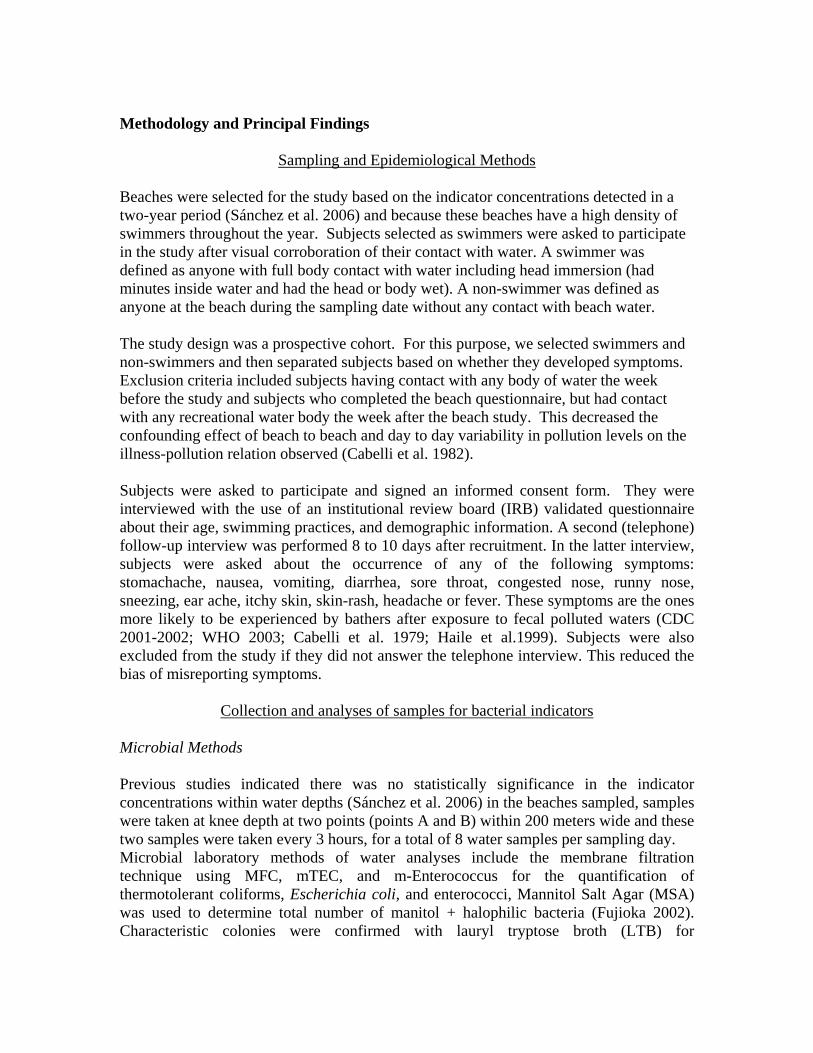
Sampling and Epidemiological Methods Beaches were selected for the study based on the indicator concentrations detected in a two-year period (Sánchez et al. 2006) and because these beaches have a high density of swimmers throughout the year. Subjects selected as swimmers were asked to participate in the study after visual corroboration of their contact with water. A swimmer was defined as anyone with full body contact with water including head immersion (had minutes inside water and had the head or body wet). A non-swimmer was defined as anyone at the beach during the sampling date without any contact with beach water. The study design was a prospective cohort. For this purpose, we selected swimmers and non-swimmers and then separated subjects based on whether they developed symptoms. Exclusion criteria included subjects having contact with any body of water the week before the study and subjects who completed the beach questionnaire, but had contact with any recreational water body the week after the beach study. This decreased the confounding effect of beach to beach and day to day variability in pollution levels on the illness-pollution relation observed (Cabelli et al. 1982). Subjects were asked to participate and signed an informed consent form. They were interviewed with the use of an institutional review board (IRB) validated questionnaire about their age, swimming practices, and demographic information. A second (telephone) follow-up interview was performed 8 to 10 days after recruitment. In the latter interview, subjects were asked about the occurrence of any of the following symptoms: stomachache, nausea, vomiting, diarrhea, sore throat, congested nose, runny nose, sneezing, ear ache, itchy skin, skin-rash, headache or fever. These symptoms are the ones more likely to be experienced by bathers after exposure to fecal polluted waters (CDC 2001-2002; WHO 2003; Cabelli et al. 1979; Haile et al.1999). Subjects were also excluded from the study if they did not answer the telephone interview. This reduced the bias of misreporting symptoms.
Collection and analyses of samples for bacterial indicators Microbial Methods Previous studies indicated there was no statistically significance in the indicator concentrations within water depths (Sánchez et al. 2006) in the beaches sampled, samples were taken at knee depth at two points (points A and B) within 200 meters wide and these two samples were taken every 3 hours, for a total of 8 water samples per sampling day. Microbial laboratory methods of water analyses include the membrane filtration technique using MFC, mTEC, and m-Enterococcus for the quantification of thermotolerant coliforms, Escherichia coli, and enterococci, Mannitol Salt Agar (MSA) was used to determine total number of manitol + halophilic bacteria (Fujioka 2002). Characteristic colonies were confirmed with lauryl tryptose broth (LTB) for
thermotolerant coliforms, urea substrate for E. coli, with Sodium Azide for enterococci. In addition, a coagulase test was performed to yellow colonies on MSA agar for the possible presence of pathogenic strains of Staphylococcus aureus. In addition, samples were analyzed for total coliforms and E. coli using the Colilert TM enzymatic method. Methods of analysis of these samples are described elsewhere (APHA 1999). The geometric means of the indicators in water were calculated for each sampling date and for each beach. Sand samples were collected two feet away from the wave splash zone at two points of 200 meters apart, every three hours. The geometric means of the indicators in these samples were also calculated. Coliphage concentrations were analyzed in water and in sand by the single layer method using the E. coli C3000 (ATCC # 15597) host for both, male and somatic coliphages as described by Grabow et al. (1986). Briefly, sterile soft Tryptic Soy Agar (0.8 % TSA) was prepared, mixed with 50 mL of marine water and with 1 mL of the host (24 h culture, 1.0 x 10⁸ cells/mL) E. coli and poured into 5 sterile disposable petri dishes (100 x 15mm). Samples were incubated at 37 ± 0.2°C and counted at 6, 18 and 24 hours. Results were expressed in plaque forming units / 100 mL of water. Statistical Analyses Indicator concentrations in water and in sand were tabulated in a database and the geometric means of the overall indicators’ concentrations per sampling date were calculated using the Minitab Statistical Program (Version 12.2). Information gathered from the interviews was recorded in categorical variables. Summary statistics were calculated for quantitative variables, while frequency distributions were obtained for qualitative variables. Normality of data was evaluated using the Shapiro-Wilk statistic (Zar 1999). Since the distribution of data was skewed, a log10 transformation was performed before performing regression analyses. Logistic regression models (multiple regression analyses) were performed using the SAS Statistical Program (Cary, NC), after the appropriate adjustments by variables such as sex, age and beach. Risk analyses were performed using the Odds Ratio Statistic (Gordis 2000) at the 95% confidence level. Principal Findings Results of this prospective epidemiological study showed that there is a higher risk of respiratory and skin symptoms in swimmers when compared to non-swimmers in beaches of Puerto Rico. Although not all samples were higher than the Puerto Rico Environmental Quality Board (PREQB) standards, we found high concentrations of all indicators in water samples, but found even higher concentrations of E. coli and enterococci in sand samples. The percent of samples exceeding the standards was higher for total coliforms and E. coli as analyzed by Colilert, but since E. coli can survive for an extended time in sand (Sánchez et al. 2006), its detection in water do not necessarily indicate recent fecal
contamination in these beaches. Prevalence rates of swimmers by beach showed higher prevalence rates in CB beach (Balneario de Carolina) and L (Luquillo beach). Luquillo beach is directly impacted by sewage effluents and by a river (Figure # 6). Isla Verde and Carolina beaches are not directly impacted by a river, but a major WWTP is located near the west side of these two beaches and contributes to the highest effluent from a treatment plant in Puerto Rico (72 MGD – millions of gallons daily). Perhaps marine water currents can move these indicators to the nearby beaches (IV and CB). On the other hand, the direct source of indicators in the beach with the highest prevalence of symptoms is unknown (Carolina Beach). Since WWTP are supposed to be chlorinated before ending up into the sea, it may be possible that non-treated storm water effluents are causing the high illness rates detected in swimmers from CB beach. Interestingly, all of the beaches included in this study are under the Blue Flag program, an international plan to designate beaches as safe for swimmers based on low concentrations of thermotolerant coliforms and enterococci in water. The blue flag microbiological standards are: 200CFU / 100 mL for thermotolerant coliforms and 35 CFU / 100 mL for enterococci. Our epidemiological study shows that there is still a risk for swimmers even when most of the water samples meet these standards as well as PREQB standards. Some indicators were slightly related to symptoms. In the analyses by beach, although non-statistically significant due to the small subject sample, coliphages were the indicators with the highest correlation coefficient with gastrointestinal symptoms. This may mean that this indicator is better in predicting the risk of gastrointestinal illness in these three beaches. For that reason, and since there was not a strong linear relation of indicators and the risk of illness, we believe that indicators in water are not predicting the risk of illnesses. If indicators are surviving in sand, then their presence in water might not be predicting the presence of pathogens present in feces at beaches from Puerto Rico (PR). Furthermore, recreational water indicators that are used in PR (thermotolerant coliforms and enterococci) may not be preventing the swimmer’s risk of illness, especially the risk of respiratory and skin symptoms. Although in the logistic regression analyses no significant linear trend between gastrointestinal illness and indicators was found, the risk of illness was increased in the 3rd and 4th quartile of increasing indicator in water. This shows that there is a risk related to an increase in coliphages in water for each 25% increase. Also, this analysis showed that E. coli and coliphages better predict the risk of respiratory symptoms and the risk of ear ache among swimmers with the highest indicator concentration in water (4th quartile). In the categorical analyses skin symptoms were related to the concentrations of E. coli in water analyzed by membrane filtration (R2 = 29.69%). Our study regressions showed a non-linear trend between illness and indicators

concentration in water. This non-linear trend was obtained probably because of the small sample size as compared to studies performed with larger sample sizes (>10,000 subjects. In fact, studies performed in United States, Hong Kong and Egypt recruited as many as 26,000, 18,000 and 23,000 subjects respectively (Cabelli et al. 1982; Kueh et al.1995; Fattal, 1986). In these studies a significant linear trend between prevalence rates of gastrointestinal illness and fecal indicators in water was observed. A lack of a straight linear relation of indicators and prevalence rates in our study may mean that the concentrations of indicators we found are not predicting the presence of the etiological agents of gastrointestinal infections and possibly pathogens in water. Other smaller epidemiological studies such as the Australia study (Corbett et al. 1993), Israel (Fattal et al. 1986) and South Africa (Von Schirnding et al. 1992) with smaller sample sizes (< 3, 000 subjects) did not find a significant linear relation of gastrointestinal illness and indicators in marine water. In the South Africa study authors postulated that the lack of significance may have been due to the uncertain sources of fecal contamination, as may be the case in Puerto Rico. High prevalence rates with low indicator concentrations were observed in this study. Similar results were found in a study where illness in swimmers was not necessarily associated with high densities of common fecal indicator bacteria in water but was associated to swimmer to swimmer transmission via the water (Calderón et al. 1991). In fact, other non-sewage sources of fecal indicators can change have an effect in the linear regression analysis needed for a dose response analysis. The prospective trial performed by Von Schirding et al. (N=733) showed a lack of statistical significance due to uncertain sources of fecal contamination (USEPA, 1986). Sources of fecal contamination in two of our beaches (Isla Verde and Luquillo), are sewage and a river, but in the other (Carolina Beach) fecal sources are unknown. It is important to notice that this beach had the highest prevalence of symptoms even when the source of indicators is unknown. Perhaps resuspension of sand or storm water effluents are the source of indicators at this beach. In fact, since E. coli and enterococci were higher in sand than in water samples, indicators found in water may be resuspended from sand sediments and they do not represent recent fecal pollution. Since there was no linear relation between the risk of illness and the presence of E. coli and enterococci in water, perhaps these indicators are not predicting the concentrations of pathogens in beach water. Surprisingly, Manitol + halophiles were high in water and in sand but it is unknown if these concentrations are dangerous for swimmers because no significant relation between them and the prevalence of symptoms were found. On the other hand, some correlations between the indicators in water samples were positive and significant (p<0.05). This may mean that our methods were successful in the analysis of indicators in water and that common indicators such as E. coli, can help us predict alternate indicators such as coliphages and Manitol + halophiles in water. Results also showed that at low levels of indicators as well as high concentrations there is a high risk of illness. Haile et al. 1999, got similar results in their epidemiological study where a non-linear trend between indicators and prevalence rates were found. A possible

reason for this finding may be that some agents in the beach environment are causing an overestimation of GI illness. Kay (2000), examined some causal agents related to GI illness other than microorganisms in water (confounders) in epidemiological studies. Some of them are: history of migraines, history of stress, frequency of diarrhea current use of prescription drugs, illnesses within 4 weeks prior to the beach study, consumption of certain food associated with diarrhea and alcohol consumption within the 7 day period after the beach study. We visually corroborated that a high percent of the young beach visitors were drinking alcohol during the beach sampling date. These confounders may have had an effect in the regression analyses. More extensive research has to be performed in order to observe a relation between indicators and risk. Since we did not confirm the symptoms by a medical examination there could be bias in what was reported due to people’s perception of the symptoms. Also, the exposure to the sun in swimmers may have harm their immune systems since they were exposed for a high period of time to hot weather temperatures making them more susceptible to other symptoms not caused by the possible pathogens in water. A larger sample size will help in the development of better linear relationship among prevalence rates and indicators. However, the risk of symptoms among swimmers was well characterized by OR values higher than 1 and by the statistically significant confidence interval values. SIGNIFICANCE There is a significant risk of respiratory and skin symptoms among swimmers from marine beaches in PR. This risk exists even at relatively low concentrations of indicators in water as shown by the positive regression coefficients. Even when waters meet the standards of the PREQB as analyzed by the membrane filtration, there is an increased risk of illness in swimmers when compared to non-swimmers. Moreover, this risk was higher in the beach with unknown sources of fecal indicators in water. As shown by the correlation analyses by beach, it seems that under tropical waters of Puerto Rico, the indicators that better predict the risk of symptoms are the coliphages and the E. coli analyzed by the enzymatic method. Results showed that concentrations of E. coli in water depend on the method of analysis, and they are present in higher concentrations in marine sand. Therefore, care should be taken when using E. coli as an indicator of fecal contamination in tropical recreational waters. Since E. coli might not be a good indicator of fecal contamination, coliphages are the indicator that may better predict the risks of illness. Further research has to be done in order to observe if coliphages survive for a long time in water and or in sand in the marine environment. This is the first epidemiological study to characterize the risk of illness among swimmers from marine bathing beaches in Puerto Rico. Care should be taken when using PREQB indicators since their concentrations in water may not be protecting swimmer’s health in our beaches. The use of coliphages as an indicator of fecal pollution will better protect

swimmer’s health in beaches from Puerto Rico.

Information Transfer ProgramThe Virgin Islands Water Resources Research Institute disseminates knowledge and information gainedfrom its research activities through a wide variety of means. Project completion reports are required for allprojects and these reports are available to the public through the WRRI. Researchers are stronglyencouraged to publish their findings not only in scholarly journals but also whenever and whereveropportunities permit in the literature.
It is recognized that much of the work done through the WRRI is very targeted to respond to localconcerns and the local audience is unlikely to use the published scientific literature. Research findingsthen are disseminated also through the WRRI web page, presentations at local workshops, seminars andconferences and also through the University’s Research and Public Service Newsletter. Researchers alsoare encouraged to issue press releases and to make presentations on their work to community groups, andclasses at UVI and other schools in the Territory.

Student SupportStudent Support
Category Section 104Base Grant
Section 104NCGP Award
NIWR-USGS Internship
Supplemental Awards Total
Undergraduate 5 0 0 0 5
Masters 1 0 0 0 1
Ph.D. 1 0 0 0 1
Post-Doc. 0 0 0 0 0
Total 7 0 0 0 7
Notable Awards and AchievementsIn execution of the project "Diversity of Freshwater Fish and Invertegbrates of St. Thomas Watershedsand its Relationship to Water Quality as Affected by Residential and Commercial Development", severalspecies have been documented for apparently the first time in St. Thomas, including the shrimpsXiphocaris elongatus, Atya innocous, and a gobiid fish, Sicydium plumieri.
The epidemiological study on the morbidity of bathers has been the first of its kind in the Caribbean. Oncepublished, this study will be extensively referenced and will also serve as a model for future studies.
Publications from Prior ProjectsNone