ar-18-386 - complete streets guidelines and implementation
TRANSCRIPT


Complete Streets Guidelines and Implementation Strategy
August 2018
Acknowledgements
This document was prepared as a collaboration between the general public and the following parties: Project Team Ali Arshad – ISL Engineering and Land Services Cameron Matwie – ISL Engineering and Land Services Dean Schick – City of St. Albert Katie Mahoney – City of St. Albert Shawn Bravender – ISL Engineering and Land Services Shelly Moulds – ISL Engineering and Land Services City of St. Albert Steering Committee Members Aleks Cieply Brian Brost Colin Prang Daniele Podlubny Dawn Fedorvich Derek Dallorto Diane Enger Jay Mason Joan Barber Jonathon Reid Kevin Cole Kristina Peter Leah Kongsrude Lory Scott Maggie Wang Marci Ng Margo Brenneis Steven Ma Tracy Tsui Will Steblyk
External Stakeholders ATCO Gas Averton Homes Canada Post Corporation Fortis Genstar Development Company Greater St. Albert Catholic Schools IBI Group Invistec Consulting Ltd. Landrex Inc. Melcor Developments RCMP Select Engineering SHAW St. Albert Bike Association Strata Developments Telus UDI WSP


Complete Streets Guidelines and Implementation Strategy
August 2018
Executive Summary
The Complete Streets Guidelines provides the overarching vision, principles and objectives to support St. Albert’s priority of creating a community designed to promote safety, connectivity, and attractiveness through a transportation network that accommodates all modes, all ages, and all abilities. It is a comprehensive document, established through engagement and aligned to community priorities and strategies that will harmonize transportation, land use, and growth and redevelopment. This document is written to provide background on Complete Streets design and philosophy, inform on how the Guidelines were developed and provide the overarching guidance with details and requirements for roadway design. Although it is intended for use and application by key stakeholders involved in the delivery of road network planning and design services, this guide may also be an information tool for residents to better understand the key considerations, objectives and principles that are being applied. What is a Complete Street?
Complete Streets represents a shift in roadway design paradigm to view roadways as more than just space for the movement of vehicles. Urban streets provide many vital functions to residents of their cities such as serving as public spaces, providing safe options for active transportation, and facilitating the shopping needs of residents. In St. Albert, this philosophy is being applied to the roadway design standards and processes and how these are used to create communities. St. Albert’s existing roadway design standards have been developed through the lens of serving vehicle movement. While this lens is a necessary part of roadway design, using only this lens limits flexibility in roadway design for serving other uses of streets. Adopting the Complete Streets philosophy allows viewing streets from other lenses and the City of St. Albert aims to achieve this through the development of Complete Streets Guidelines. Development Process
To ensure that the Guidelines aligned with community expectations and values, the City conducted stakeholder engagement during the development of the goals and objectives for Complete Streets. Residents and stakeholders were given the opportunity to participate in events and activities about what the most important considerations for roadways were. Recurring themes received focused on: Improve connections for pedestrians, cyclists, and transit users; Create more green space and sidewalk amenities; Improve crosswalk safety; Accommodate winter uses; Enhance citizens’ quality of life; Maintain St. Albert’s character. This input was used to create the vision and goals for the project. A second round of stakeholder engagement was conducted during the development of the Complete Street typologies and cross-sections. Initial comments from the City stakeholders and external stakeholders were used to refine the proposed typologies and cross-sections prior to being presented to the public. Responses from the public engagement sessions confirmed that the typologies and cross-sections helped achieve the goals of improving safety, enhancing pedestrian and cyclist connections, and creating attractive places within the City.

Complete Streets Guidelines and Implementation Strategy
August 2018
Complete Streets Guidelines
To help communicate the difference between roadway function and St. Albert’s Complete Streets, a new set of roadway descriptions has been developed:
Boulevards – regional streets that support the Edmonton Metropolitan Area, serving local and regional travel, typically used for public transit services, and often providing commercial / large load movement. Examples of this would be St. Albert Trail (Highway 2), and Ray Gibbon Drive. Traditionally defined as a highway, freeway, or expressway. Crosstowns – major streets that allow users to travel across the City, without changing corridors. These streets provide connectivity for public transit buses and may provide for commercial / large load movements. Traditionally defined as a major arterial. Connectors – major streets that connect Crosstowns together. Connectors provide connectivity for transit buses and may provide for commercial / large load movement. These have traditionally been labeled as an undivided arterial. Neighbourhoods – minor streets that provide direct access to, and around a neighbourhood. Capable of accommodating public transit buses. Traditionally labelled as a collector. Locals – minor streets that provide direct access to the front of a properties, do not accommodate public transit buses transit or large load movement, and typically connect to Neighbourhood roadways. Laneways – minor roads that provide access to the rear of a property and do not provide for public transit buses or commercial / large load movement.
The Complete Streets roadway network is shown in the Figure E.1. Each of these roadway functions was then combined with the following land use form options to create unique streets that reflect their local surroundings:
Commercial: land use that provides goods and services to the community, including mixed use development. Residential: land use that provides a variety of housing types for the community. Employment: land use that provides business and industrial services to the community.
The Guidelines acknowledges that opportunities exist to implement Complete Streets through both new development projects and retro-fitting projects. The latter of those scenarios will create opportunities of engagement with stakeholders and residents, as key considerations will need to be made towards “trade-offs” in how the road system looks and how it provides accommodation. Guidance on individual elements, the “trade-off” process, and real world examples are included in the main document.

Complete Streets Guidelines and Implementation Strategy
August 2018
Figure E.1 Complete Streets Roadway Network
Implementation Plan
Roadway planning and design does not work in isolation from other City initiatives, and this new approach to will require updates to City policies, plans, and processes, and will require collaboration between many stakeholders. The table below summarizes each of the action items identified and their associated deliverables and recommended timeframes.

Complete Streets Guidelines and Implementation Strategy
August 2018
Table E.1 Implementation Plan Summary
Action Item Lead Department Deliverable Timeframe
Update Municipal Engineering Standards 1. Incorporate Complete Streets Design
Guidelines for interim use 2. Finalize updates to Engineering
Standards
Engineering Updated Municipal Engineering Standards
Interim – 2018 Final – 2019
Amend Transportation System Bylaw 3. Update wording to new roadway
typology 4. Update Schedule A to show new
roadway network 5. Present to Council 6. Alberta Transportation approval
Engineering Bylaw Amendment 2019
Amend Traffic System Bylaw 7. Add additional information for cyclists
at intersections and transit stops
Engineering Bylaw Amendment 2019
Active Transportation Plan 8. Identify gaps in cycling network
between future areas and existing network
9. Outline plan to complete network a. Retro-fit Strategy and pilot
projects
Engineering Network Prioritization Plan
Gaps – 2018 Plan
Development – 2019/2020
Retro-fit Pilot projects - TBD
City Departments Education Component 10. Develop education component
Engineering Summary of organizational impacts / action table
2019
Updates to Processes of Departments 11. Outline changes to department
processes
Multiple Memorandums from each Department outlining process changes
2020
Update Complete Streets Guidelines 12. Monitor and identify improvement
areas 13. Complete report to identify gaps in
design guidance and emerging topics 14. Update Guidelines
Engineering Updated Guidelines Long-term / Ongoing
Summary
The Complete Streets Guidelines and Implementation Strategy is another critical step in developing St. Albert’s road network into a fully integrated and connected transportation network that safely accommodates all modes of travel, all ages and all abilities. Using the goals and objectives identified by stakeholders and the best practices outlined in the Guidelines, St. Albert will ultimately provide the best real-world examples in how integration of Complete Streets can improve the road network from the past to the future.

Complete Streets Guidelines and Implementation Strategy
August 2018
Table of Contents
1.0 Introduction .......................................................................................................... 1 1.1 What is a Complete Street? 1 1.2 Intent of the Document 1 1.3 Applications of the Guideline 2 1.4 Structure of the Guide 2
2.0 Guidelines Development Process ....................................................................... 4 2.1 Background Review 4 2.2 Best Practices Review 4 2.3 Stakeholder Consultation 5 2.4 Next Steps 7
3.0 Current State of Roadway Design and the Transition to Complete Streets ..... 8 3.1 Municipal Plans 8 3.2 Municipal Engineering Standards 9 3.3 Bylaws 9
4.0 Strategic Framework .......................................................................................... 11 4.1 Vision 11 4.2 Guiding Principles and Objectives 12 4.3 Performance Metrics 13 4.4 Complete Streets Process 15
5.0 St. Albert’s Street Typology and Cross-sections ............................................. 23 5.1 Boulevards 25 5.2 Crosstown Commercial 27 5.3 Crosstown Residential 28 5.4 Crosstown Employment 29 5.5 Connector Commercial 30 5.6 Connector Residential 31 5.7 Connector Employment 32 5.8 Neighbourhood Commercial 33 5.9 Neighbourhood Residential 34 5.10 Neighbourhood Employment 35 5.11 Local Residential 36 5.12 Local Employment 37 5.13 Laneway Commercial / Employment 38 5.14 Laneway Residential 38
6.0 Elements ............................................................................................................. 39 6.1 Vehicle Realm 40 6.2 Pedestrian Realm 42 6.3 Cycling 47 6.4 Transit 55 6.5 Summary of Elements by Typology 59 6.6 Guidelines for Intersections 61 6.7 Speeds and Safe Systems 63 6.8 Utilities 65

Complete Streets Guidelines and Implementation Strategy
August 2018
7.0 Trade-offs ........................................................................................................... 67 7.1 Introduction 67 7.2 Trade-offs in St. Albert’s Street Typologies 67 7.3 Trade-offs in Retro-fitting Streets 68
8.0 Complete Streets Implementation .................................................................... 74 8.1 Introduction 74 8.2 Implementation Action Items 74
9.0 Summary ............................................................................................................ 77 APPENDICES Appendix A Background Review
Appendix B Best Practice Report
Appendix C Stakeholder Engagement Reports TABLES
Table E.1: Implementation Plan Summary
Table E.1 Implementation Plan Summary .................................................................................................8
Table 4.1: Sample of Potential Performance Metrics ............................................................................... 14
Table 4.2: Sample Corridor Performance Metrics .................................................................................... 14
Table 5.1: St. Albert Complete Streets Typologies ................................................................................... 23
Table 6.1: Travel Lane Widths ................................................................................................................. 40
Table 6.2: Turning Lane Widths ............................................................................................................... 40
Table 6.3: Parking Lane Widths ............................................................................................................... 41
Table 6.4: Frontage Zone Widths ............................................................................................................. 42
Table 6.4: Through Zone Widths .............................................................................................................. 44
Table 6.5: Furnishing Zone Widths .......................................................................................................... 45
Table 6.6: Multi-use Trail Widths .............................................................................................................. 48
Table 6.7: Shared Lane Widths ................................................................................................................ 49
Table 6.8: Bike Lane Widths .................................................................................................................... 50
Table 6.9: Buffered Bike Lane Widths ...................................................................................................... 51
Table 6.10: Protected Bike Lane Widths .................................................................................................... 54
Table 6.11: Bus Lane Widths ..................................................................................................................... 58
Table 6.12: Summary of Elements By Typology ........................................................................................ 59
Table 8.1: Implementation Plan Summary ............................................................................................... 76

Complete Streets Guidelines and Implementation Strategy
August 2018
FIGURES Figure E.1: Complete Streets Roadway Network
Figure E.1 Complete Streets Roadway Network ........................................................................................ 7
Figure 4.1: Complete Street's Process ...................................................................................................... 15
Figure 4.2: Complete Streets Roadway Hierarchy .................................................................................... 17
Figure 4.3: Complete Street Zones ........................................................................................................... 20
Figure 5.1: St. Albert Typology Street Network ......................................................................................... 24
Figure 6.1: Typical Pedestrian Dimensions ............................................................................................... 43
Figure 6.2: Shared Lanes .......................................................................................................................... 49
Figure 6.3: Bike Lanes .............................................................................................................................. 50
Figure 6.4: Buffered Bike Lanes ................................................................................................................ 51
Figure 6.5: Uni-directional Protected Bike Lanes ...................................................................................... 52
Figure 6.6: Bi-directional Protected Bike Lanes ........................................................................................ 53
Figure 6.7: Effect of Corner Radius on Pedestrian Crossing Distance and Directness ............................. 61
Figure 6.8: Protected Bike Lanes at Intersections ..................................................................................... 62
Figure 6.9: Protected Bike Lanes at Intersections ..................................................................................... 62
Figure 6.10: Probability of Fatal Injury for a Pedestrian after being struck by a Vehicle at Different Speeds .................................................................................................................................... 63
Figure 6.11: Stopping Distances: Speed and Braking ................................................................................. 64


Complete Streets Guidelines and Implementation Strategy
August 2018
Glossary
Arterial – A high-capacity urban roadway that prioritizes mobility over local access. Ancillary Zone – The space within the interstitial zone that can be used for on-street vehicle parking, transit loading zone or bus bay, bicycle parking, for seating, or for public art. Bike Lane – Pavement space dedicated to one-way bicycle traffic, separated by a painted line. Bike Lane, Buffered – Pavement space dedicated to one-way bicycle traffic, separated by a painted buffer. Bike Lane, One-way Protected – Pavement space dedicated to one-way bicycle traffic, separated by a concrete buffer. Bike Lane, Two-way Protected – Pavement space dedicated to two-way bicycle traffic, separated by a concrete buffer. Boulevards – Regional streets that support the Edmonton Metropolitan Area, serving local and regional travel, typically used for public transit services, and often providing commercial / large load movement. Examples of this would be St. Albert Trail (Highway 2), and Ray Gibbon Drive. Traditionally defined as a highway, freeway, or expressway. Bus Lane – A lane dedicated for public transit buses. Collector – low to moderate urban capacity roadway that balances mobility and access requirements. Commercial – land use that provides goods and services to the community, including mixed use development. Connectors – major streets that connect Crosstowns together. Connectors provide connectivity for transit buses and may provide for commercial / large load movement. These have traditionally been labeled as an undivided arterial. Crosstown – major streets that allow users to travel across the City, without changing corridors. These streets provide connectivity for public transit buses and may provide for commercial / large load movements. Traditionally defined as a major arterial. Curb Zone – This space is used for the curb and gutter to collect surface drainage. Elements – Infrastructure and amenities within zones dedicated for a specific function. Employment – land use that provides business and industrial services to the community. Frontage Zone – The pedestrian realm space closest to the property line, providing a buffer for pedestrians from opening doors and acts as a shyline offset from the architectural elements of the building. This space can also be used for retail displays and landscaping, or café seating. Furnishing Zone – The pedestrian realm space between the through zone and the curb, dedicated for street amenities, landscaping, power and telecommunications furniture, and transit shelters. Interstitial Realm – The zone connecting the pedestrian realm and the vehicle realm, consisting of the ancillary zone and the curb zone.

Complete Streets Guidelines and Implementation Strategy
August 2018
Land Use Context – The land use adjacent to a street; commercial, employment, or residential. Laneways – minor roads that provide access to the rear of a property and do not provide for public transit buses or commercial / large load movement. Locals – minor streets that provide direct access to the front of a properties, do not accommodate public transit buses transit or large load movement, and typically connect to Neighbourhood roadways. Median – The space dividing a major roadways travel lanes. The space can be used for turning lanes or landscaping. Neighbourhoods – minor streets that provide direct access to, and around a neighbourhood. Capable of accommodating public transit buses. Traditionally labelled as a collector. Parking Lane – An on-street lane dedicated to the parking of vehicles. Pedestrian Realm – The zone dedicated to pedestrians, it consists of the frontage zone, the through zone, and the furnishing zone. Residential – Land use that provides a variety of housing types for the community. Roadway Function – The transportation function of a street; providing mobility across a region, city or neighborhood, or providing access to a property. Safe System – A design approach that aims to eliminate road crash fatalities and serious injuries by reconfiguring the road network to forgive human errors. Shared Lane – A travel lane shared by bicycles and vehicles. Through Zone – The pedestrian realm space clear of infrastructure or signage, dedicated for pedestrian travel. Transit Zone – The pavement space used by a public transit bus to load/unload passengers. Travel Lane – A lane which can be used for vehicle travel. Turning Lane – A lane used for vehicles making turning movements. Typologies – Different street cross-sections created through the combination of roadway function and land use context. Vehicle Realm – The zone dedicated to travel for bicycles, vehicles, buses, and trucks. Vision Zero – A multi-national road safety project to eliminate death and serious injury from roadways.

Complete Streets Guidelines and Implementation Strategy
August 2018
Acronyms
ATP – Active Transportation Plan CPTED – Crime Prevention Through Environmental Design km/h – Kilometer Per Hour LUB – Land Use Bylaw LRT – Light Rail Transit m – Meter MDP – Municipal Development Plan ROW – Right-Of-Way TAC – Transportation Association of Canada TMP – Transportation Master Plan


Complete Streets Guidelines and Implementation Strategy
August 2018 Page 1
1.0 Introduction
1.1 What is a Complete Street?
Complete Streets represents a shift in roadway design paradigm to view roadways as more than just space for the movement of vehicles. Urban streets provide many vital functions to residents of their cities such as serving as public spaces, providing safe options for active transportation, and facilitating the shopping needs of residents. In St. Albert, this philosophy is being applied to the roadway design standards and processes and how these are used to create communities.
Example of a Complete Street in Gaetz Avenue, Red Deer
St. Albert’s existing roadway design standards have been developed through the lens of serving vehicle movement. While this lens is a necessary part of roadway design, using only this lens limits flexibility in roadway design for serving other uses of streets. Adopting the Complete Streets philosophy allows viewing streets from other lenses and the City of St. Albert aims to achieve this through the development of Complete Streets Guidelines. 1.2 Intent of the Document
The Complete Streets Guidelines and Implementation Strategy is a single point of reference that provides comprehensive guidance for incorporating Complete Streets in St. Albert. Complete Streets are intended to increase the attractiveness, convenience, and safety for all modes of transportation at the multiple levels of the roadway network. The Guidelines provide clear objectives, principles, and considerations within a framework that encourages collaboration between planners, engineers, and development stakeholders. The objective of the collaborative framework is to create a public right-of-way that ensures land uses are integrated and contribute to a people-oriented street environment that works for everyone.

Complete Streets Guidelines and Implementation Strategy
Page 2 August 2018
1.3 Applications of the Guideline
The document will provide guidance on new roadways, as well as a systematic approach to retrofitting existing roads. As such, the document is intended to be used by engineers, planners, and the development community during all street planning or design projects within the City of St. Albert. The Guidelines are most applicable in the planning and preliminary design project phases, though they may be useful to later phases in some street design projects. The range of applicable project considerations for Complete Streets includes (but is not limited to): Plans Development Area Structure Plans, City Plans (Transportation Master Plan, Active Transportation Plan, Transit Plan, Parks Plans) Corridor Studies / Plans Development applications New sidewalk / trail Projects New roadway construction Reconstruction or Revitalization of roadways Downtown Area Redevelopment Projects New sidewalk / trail installation Transportation safety or local improvement projects Utility projects (involving utility cut repairs that may impact the street segment) The Complete Streets Design Guidelines and Implementation Strategy is intended to be a living document that evolves overtime to reflect ongoing evolution of City goals and local priorities. 1.4 Structure of the Guide
The Guidelines are broken into nine chapters that provide a range of information to allow readers to be informed on the background of Complete Streets, how the document was developed for St. Albert, the overarching priorities and principles important to the community, roadway design considerations, and layouts and implementation of Complete Streets. Chapter 1: Introduction Provides oversight on the intent and applications of the document. Chapter 2: Guidelines Development Process Provides an overview of actions and information that influenced creation of the Guidelines and
informed the outcomes. Chapter 3: Current State of Roadway Design and the Transition to Complete Streets Provides an overview of the impacts of bylaws, municipal strategies, and engineering
standards affect Complete Streets, and what may need to change within these documents. Chapter 4: Strategic Framework Provides the overall vision and guiding principles for Complete Streets, and potential
performance metrics.

Complete Streets Guidelines and Implementation Strategy
August 2018 Page 3
Chapter 5: St. Albert’s Street Typologies and Cross-sections Provides an overview of the street hierarchy within the City using Complete Streets and the
related cross-sections for each. Chapter 6: Elements Provides an overview of the various elements used to create a Complete Street. Chapter 7: Trade-offs Provides an overview of determining which elements should be modified if sufficient right-of-
way is not available. Chapter 8: Complete Streets Implementation Provides an overview of tasks needed to effectively implement Complete Streets within St.
Albert. Chapter 9: Overview Provides a closing summary to the report.

Complete Streets Guidelines and Implementation Strategy
Page 4 August 2018
2.0 Guidelines Development Process
2.1 Background Review
The goal of St. Albert’s Complete Streets Guidelines is to ensure that street design in the City takes into consideration users and land use being served by each individual roadway. In recognition that these two considerations create variety associated with the character and context of each roadway, the Guidelines were developed to address required flexibility in design standards to ensure safe access and efficient operations for all street activities and functions. One of the first steps of the project involved a background review of the City’s plans and policies to confirm conformance with the aim of adding flexibility to roadway design. The background review also served to identify gaps between the intent of the Complete Streets Guidelines and the City’s current roadway design standards, various master plans, and bylaws. St. Albert’s plans and policies share aspirations for increasing the diversity of transportation mode choices and development types available in the City and help shape the goals and principles of the Complete Streets Guidelines, specifically: 2015 Transportation Master Plan (TMP) identifies a need for the establishment and implementation of
design standards to accommodate all network users for the appropriate function of the roadway. City Council’s Strategic Priority (2018 – 2021): Building a Transportation Network: Integrated
Transportation Systems which strives to increase the efficient and effective movement of people and goods in St. Albert through integrated modal planning and regional cooperation.
Municipal Development Plan (MDP) describes neighbourhood activity centres with mixed use, higher density nodes as a strategy for growth management.
2.2 Best Practices Review
Many cities across North America apply Complete Streets Guidelines to add flexibility in roadway design practices. The Canadian cities of Calgary, Edmonton, and Toronto have all developed Complete Streets Guidelines. Two other Canadian cities have also developed similar Complete Street documents: Airdrie’s Complete Streets Toolbox, and the Regional Municipality of Waterloo’s Context Sensitive Regional Transportation Corridor Guidelines. A review of the content, layout, and structure within these documents identified two main strategies used by municipalities to develop Complete Street guidelines: 1. Develop additional cross-sections to allow for the consideration of some new land uses. 2. Let users of the guide create unique cross-sections from three different parameters; type of building
frontage, land use context, and the functional classification. Additionally, the background review identified the key design elements for consideration during roadway planning and design activities. A comparison of the design elements in each of Calgary, Edmonton, and Toronto’s Guidelines influenced the list of elements selected for St. Albert’s Complete Streets Guidelines. A full report can be found in Appendix B. The strategic direction taken for St. Albert’s Complete Streets Guidelines is the provision of clearly defined roadway cross-sections that incorporate the elements common to many Complete Streets Guidelines throughout Canada, with the local needs identified through stakeholder engagements. Through this document, a typology of streets has been developed that reflect the alignment of roadway function and land use form associated with commercial, residential, and employment land use zones.

Complete Streets Guidelines and Implementation Strategy
August 2018 Page 5
2.3 Stakeholder Consultation
There were two key phases during the development of the Guidelines that involved stakeholder engagement: 1. Development of the Guideline’s goals and objectives 2. Development of street typologies and roadway cross-sections 2.3.1 Development of Goals and Objectives
The principles and objectives shared in Section 4.1 have been developed in collaboration with the following groups: Residents: through a Public Open House and an online survey City Stakeholders: through a questionnaire and a half-day workshop External Stakeholders: through a half-day workshop Steering Committee: through Steering Committee Meetings During the engagement process, each group was asked to provide input on the desired function of streets in St. Albert as well as the most important considerations for roadway design. Various exercises were used to gain this input, from question and answer sessions, dotmocracy trade-off activities, comment boards, and mock roadway design exercises.
Dotmocracy Activity from Open House #1

Complete Streets Guidelines and Implementation Strategy
Page 6 August 2018
2.3.1.1 Input Received and Influence to the Guidelines
The following reoccurring themes were received: Improve connections for pedestrians, cyclists, and transit users; Create more green space and sidewalk amenities; Improve crosswalk safety; Accommodate winter uses; Enhance citizens’ quality of life; Maintain St. Albert’s character. The stakeholder workshops also revealed aspirations for streets to serve purposes beyond mobility, such as being open spaces and places for people to gather. Specifically in reference to St. Albert’s streets, attendees mentioned narrower spaces for vehicles and lower design speeds as important goals. More information can be found in Appendix C within the Workshop Summaries report. These key themes were used to create the goals and objectives for the project which in turn helped develop the street typologies and cross-sections. The goals and objectives were a critical component to the development of these Guidelines. They act as a foundation to which the rest of the document is built, from the prioritization of roadway needs to areas of opportunity for consideration. 2.3.2 Development of Street Typologies and Proposed Cross-Sections
Preliminary street typologies and roadway cross-sections were developed largely through the results of public and stakeholder feedback received on goals and objectives. This feedback was used to propose typologies and cross-sections that were presented to the following stakeholder groups during next sessions of engagement.
Complete Streets Element Activity for St. Albert Trail at Open House #1

Complete Streets Guidelines and Implementation Strategy
August 2018 Page 7
Complete Streets element activity for Perron Street Complete Streets element activity for Dawson Road
2.3.2.1 Input Received and Influence to the Guidelines
In recognition that the varying stakeholders provide different perspectives of the applications of the Guidelines, input was associated with: Residents: User needs and expectations from the roadway network. City Stakeholders: Functional service delivery requirements and considerations of the road network can
be improved to enhance service delivery, from planning, engineering and operational considerations. External Stakeholders: The alignment of “market need” and improved opportunity to result in high
quality development. The street typologies developed aim to create a network of streets which are well connected for pedestrians and cyclists. The development of new commercial cross-sections for mixed-use environments allow for additional sidewalk amenities and green space. The typologies and cross-sections have all been constructed with the goal of enhancing the quality of life of residents while still maintaining St. Albert’s established character. Responses from engagement sessions confirmed that the typologies and cross-sections helped achieve the goals of improving safety, enhancing pedestrian and cyclist connections, and creating attractive places within the City. Refer to Appendix C for details of the entire Stakeholder Engagement process. 2.4 Next Steps
The development of the Guidelines is the primary action to begin integration of Complete Streets in St. Albert. Further steps are required that align to: Updates of supportive or lead documents to reference or communicate Complete Streets requirements
or considerations. Education to stakeholders on Complete Streets integration to the City and process amendments. Collaboration with stakeholders to identify and receive necessary inputs or provide information in
consideration of their processes and alignment to Complete Streets activities. Identification of capital or maintenance project linkages to Complete Streets. Details of an Implementation Plan which will help to guide the next stages of Complete Streets have been included in Section 8.
Complete Streets Guidelines and Implementation Strategy
Page 8 August 2018
3.0 Current State of Roadway Design and the
Transition to Complete Streets
The adoption of a new roadway design philosophy presents opportunities to update policies, processes, and standards. There are also many areas of the planning, design, and operations which already align with the Complete Streets Guidelines. Complete Streets allows for flexible road design standards which can better accommodate the mode priorities associated with specific land uses. The rules defined for vehicles, pedestrians, and cyclists do not see a change with Complete Streets, only the infrastructure being provided for each of the modes. The purpose of the roadway system is still to provide access and mobility for employment, education, shopping, and recreation purposes. Complete Streets expands the mode choices available to accomplish these trip purposes. 3.1 Municipal Plans
3.1.1 Municipal Development Plan
A major policy objective being furthered by the Complete Streets Guidelines is the consideration of increased diversity in development types in the Municipal Development Plan (MDP). One growth management strategy outlined in the MDP is encouraging mixed use development at strategic locations across the City. The success of mixed use developments depends on the multi-modality of the transportation network surrounding the development. Streets which allow walking and cycling for shorter trips make mixed-use development more viable. The development of commercial street-oriented cross-sections in these Guidelines is a significant step in being able to implement mixed-use developments in St. Albert. 3.1.2 Transportation Master Plan
Multiple goals and objectives of the City’s 2015 Transportation Master Plan (TMP) tie to initiatives and considerations of Complete Streets. Particular areas include: Road Network – The TMP identifies the need to design new roads and intersections safely for all users. Active Transportation Network - The TMP outlines a plan to increase the mode choices available to St. Albert residents. Increasing the safety and attractiveness of cycling has been a key focus of providing additional choices. The TMP includes a proposed active transportation network for the City with City-Wide Primary cycling routes along arterial roads. Public Transportation Network – Provide a street network capable of supporting and enhancing transit services, and land use integration to support density around future LRT stations. Goods Movement Network – Support the movement of good through a street network and cross-sections providing connections to city-wide and regional industrial and employment areas. Intelligent Transportation Systems – Incorporating all mode choices into street design and the street network helps offer solutions to information being received from Intelligent Transportation Systems. 3.1.3 Universal Access and Barrier Free Prioritization Plan
A key component of a universally accessible and barrier-free St. Albert is ensuring that the city’s streets, serving as both links and spaces, are designed for all modes, all ages, and all abilities. The Complete Streets Guidelines incorporate accessibility into street cross-sections and street networks.
Complete Streets Guidelines and Implementation Strategy
August 2018 Page 9
3.2 Municipal Engineering Standards
The Engineering Standards include design and construction details for the construction of roads, sidewalks, underground infrastructure, and landscaping. The cross-sections presented in these Guidelines largely reallocate roadway space for different uses and in the majority of cases they do not present changes to the design and construction details for roads, sidewalks, underground infrastructure, and landscaping. Key updates to the Standards will be inclusive of: References to roadway classification with new street typologies. Updates on roadway cross-sections:
o Cross-section drawings in Appendix A will be replaced with new street cross-sections. o Information on operating speeds, horizontal criteria, and pavement structures is defined according
to the type of cross-section in Section 3.0. The information provided may remain unchanged but will be defined according to the new
street cross-sections. In the case of operating speeds, additional notes should be provided regarding the Safe
Systems approach to speeds. Updates to design and construction procedures include:
o Changing sidewalk widths references in Section 4.0 to reflect the sidewalks widths shown in the cross-sections in these Guidelines.
o Adding materials and procedures for the construction of on-street cycling lanes to Section 3.0. o Adding new information on soil cell materials and placement in hard-surfaced commercial areas to
Section 9.0. 3.3 Bylaws
Multiple Bylaws exist that provide guidance on roadway / land use operations, considerations, and regulatory requirements. The following identifies minor amendments to bylaws that will create consistency in messaging and align overarching direction or information from the Complete Streets Guidelines. 3.3.1 Transportation Systems Bylaw
The current Transportation Systems Bylaw references standard Transportation Association of Canada (TAC) roadway classifications; arterial, collector or local. The development of new roadway typology will need to align to the overall network classifications and be communicated for full network understanding and for planning of expansion. The new street typology introduced in these guidelines needs to be adopted in the Transportation System Bylaw and the map in Schedule A will need revisions. 3.3.2 Land Use Bylaw
The new cross-sections will align with the mixed-use zones identified in Section 11.0 of the Land Use Bylaw. The previous roadway cross-sections did not provide a standard which would fit the street-fronting design of mixed-use developments. The new crosstown, connector, and neighbourhood cross-section in commercial zones allow for developments of this type to be implemented successfully. The introduction of on-street parking in commercial mixed-use zones may present an increase in the supply of parking. The parking rates outlined for commercial mixed-use zones should be evaluated to ensure it is
appropriate.

Complete Streets Guidelines and Implementation Strategy
Page 10 August 2018
3.3.3 Traffic Bylaw
One major feature of crosstown cross-sections presented in the Guidelines is the accommodation of on-street cycling. The Traffic System Bylaw currently permits cycling on sidewalks in the City, but in high-traffic pedestrian areas this can create conflicts between pedestrians and cyclists. Even with the provision of dedicated cycling facilities, the Bylaw could still allow cycling on sidewalks. Consideration should be made towards prohibiting cycling on sidewalks on streets with dedicated on-
street cycling facilities, with children and parents accompanying children exempt from the regulation. o In areas without dedicated on-street cycling infrastructure, cycling on sidewalks could continue to
be allowed. Consideration should be made for clear regulations for interactions between cyclists travelling in cycle
lanes and vehicles making right-turn movements. Consideration should be made for regulations for interactions between cyclists and pedestrians at bus
stops

Complete Streets Guidelines and Implementation Strategy
August 2018 Page 11
4.0 Strategic Framework
Streets serve many different functions for a wide range of users within the city and the design of streets highlights the priorities and values of the city. The Complete Streets Design Guidelines shall help build an environment focused on serving the needs of all road users. Designing a community with the Complete Streets approach shall result in streets which are safe and attractive and serve as both places and links. 4.1 Vision
A community designed to
promote safety, connectivity,
and attractiveness through a
transportation network that
accommodates all modes,
all ages, and all abilities.

Complete Streets Guidelines and Implementation Strategy
Page 12 August 2018
4.2 Guiding Principles and Objectives
The overall objective of Complete Streets is to balance the needs and priorities of all road users and uses of the road right of way. The end result should be a network that is linked to service the needs of adjacent development and support a multi-modal and connected environment that promotes confidence in safety and efficiency for travel. The following goals and objectives for St. Albert’s integration of Complete Streets were developed from stakeholder and public feedback: Goal 1: Streets should safely accommodate users of all ages and abilities.
Objectiive 1.1: Design roadways for efficient but safe vehicular travel, with safe design speeds, clear sightlines and other elements of safety.
Objectiive 1.2: Use design elements to protect exposed users of the street – pedestrians and cyclists – from vehicles.
Objectiive 1.3: Ensure that all major and secondary streets are designed so that transit can operate reliably, without delay, and so that transit stops that are accessible and offer a high degree of amenity can be provided.
Objectiive 1.4: Design streets to ensure mobility and access for persons with limited mobility, including children, seniors and persons with disabilities.
Goal 2: The street network should be well-connected, provide direct paths of travel, and should not act as barriers.
Objectiive 2.1: Prioritize directness of pathways and frequent connectivity in the design of new streets.
Objectiive 2.2: Seek to ensure that large and/or busy streets can be crossed conveniently, safely, comfortably and without undue delay.
Goal 3: Streets should provide mobility, access to homes, businesses and schools, and civic space for leisure, recreation and other activities.
Objectiive 3.1: Ensure that streets provide mobility for all users.
Objectiive 3.2: Ensure that streets provide convenient access to adjacent land uses, both existing and planned.
Objectiive 3.3: Ensure that streets are not merely transportation arteries, but support other possible uses.
Objectiive 3.4: Where rights-of-way permit, provide a generous pedestrian realm and/or landscaping.
Objectiive 3.5: Design streets to support attractive urban design/placemaking and accommodate social uses such as sidewalk café seating.
Goal 4: Streets should provide choices for all users, and be fair in their allocation of space for all users.
Objectiive 4.1: Design streets to accommodate modes of transportation that are low-cost for users including walking, cycling and transit.
Objectiive 4.2: Ensure that low-cost modes are treated equitably in the allocation of space.

Complete Streets Guidelines and Implementation Strategy
August 2018 Page 13
Goal 5: Streets should be aesthetically attractive, reflecting St. Albert’s appreciation of nature, unique architecture, and the botanical theme.
Objectiive 5.1: Ensure that space for travel is allocated efficiently, so that remaining space for landscaping and other uses can be maximized.
Objectiive 5.2: Integrate provision of greenery into the core design process, rather than merely adding landscaping as an afterthought.
Objectiive 5.3: Provide tree canopy for summer shade and winter time protection against the elements.
Goal 6: Streets should support the land use, economic development, environmental sustainability, personal security, public health, cost-effectiveness and other objectives.
Objectiive 6.1: Minimize the width of rights-of-way to maximize space for development, civic space and other non-transportation uses.
Objectiive 6.2: Use street design as an avenue to limit greenhouse gas emissions.
Objectiive 6.3: Apply principles of Crime Prevention Through Environmental Design (CPTED) including pedestrian-scale lighting and clear sightlines.
Objectiive 6.4: Design streets to promote active transportation including walking and cycling.
Objectiive 6.5: Take into account winter conditions, including usability, safety and maintenance needs, in the design of streets.
Objectiive 6.6: Design streets for durability and ease of maintenance.
4.3 Performance Metrics
As the Complete Streets Design philosophy is incorporated into the City’s processes and plans, there will be opportunity to relate performance metrics to measure the success of future projects and the overall progress in meeting the goals and objectives of these Guidelines. Two lists are provided, one of general performance metrics (Table 4.1) and another with examples of roadway corridor metrics (Table 4.2). The lists are intended to be used to generate discussion around feasibility and effectiveness for measures to be adopted and applied to projects that align to Complete Streets implementation. Some metrics require extensive data collection, which may not be part of current processes, and as such, consideration may be given to availability of resources and appropriateness to create new or update current practices.

Complete Streets Guidelines and Implementation Strategy
Page 14 August 2018
Table 4.1: Sample of Potential Performance Metrics
Metrics Targets
Citywide combined pedestrian and bicycle mode share for trips of one kilometer, five kilometers or shorter
Upward trend
Single occupant commuting Downward trend Number of pedestrian and bicycle related collisions Downward trend Number of pedestrian and bicycle fatalities Downward trend Total roadway crashes and injuries from all roadway crashes Downward trend Ratio of bicycle facility km to road km Upward trend Linear meters of sidewalks Upward trend Vehicle miles traveled per capita Downward trend Average vehicle occupancy Upward trend Roadway segments using green infrastructure to manage storm water runoff (as a percent of the total network in the city)
Upward trend
Tree canopy along streets Upward trend Sales revenue per square meter in Downtown Upward trend
Table 4.2: Sample Corridor Performance Metrics
Area Metrics Automobile Average travel time
Speed limit compliance Transit Peak travel time
Average peak period speed compared to free-flow speed Average person delay
Bicycle Provision of dedicated and protected facilities Peak travel time Bicycle Level Of Service based upon level of dedicated facility in comparison to
automobile speeds Pedestrian Number and condition of corner wheelchair ramps
Available sidewalk width (minimum standard TBD) Percentage of sidewalk width compared to overall street width Network connectivity index (ratio of the number of links to the number of intersections
and cul-de-sacs) Average pedestrian crossing delay Block lengths Availability of safety infrastructure (flashing beacons, median refuges, advance yield
lines, etc.)

Complete Streets Guidelines and Implementation Strategy
August 2018 Page 15
4.4 Complete Streets Process
4.4.1 Applying the Complete Streets Lens
The information in these Guidelines is intended to be applied to the planning and design of new streets as well as work on existing streets. The cross-sections included in Section 5 have been created with an established process which considers the many different land use forms and roadway functions which streets serve. Understanding the process which led to the development of these cross-sections is necessary for proper application of each cross-section to St. Albert’s street network. Knowledge about the process is also important for the planning and design of existing streets. Starting with a blank slate is not possible for all street projects and in some cases St. Albert’s existing streets will have to be retro-fitted to meet the needs of all users being considered. In these cases, understanding of the Complete Streets process will be even more vital because the street will require a unique design based on the design elements presented in Section 6. The information below seeks to aid users of the Guide in applying the Complete Streets lens to the planning and design of the streets in St. Albert.
Figure 4.1: Complete Street's Process
Figure 4.1 outlines the process for determining the cross-sections that have been developed for St. Albert. Breaking the street space into zones and elements allows for additional consideration given to street uses beyond vehicle movement.
Step 1: Typology
• What is the existing/proposed roadway function?
• What is the existing/proposed land use form?
Step 2: Zones
• Divide the street into zones based on their purpose - roadway space versus pedestrian realm space
Step 3: Elements
• What features can be included to help fulfill the streets' purpose?
Step 4: Trade-offs
• Will all the elements fit in the space?• How can all modes be accomodated safely?
Step 5: Finalize
Cross-section
• Does the cross-section serve the original intended purpose?

Complete Streets Guidelines and Implementation Strategy
Page 16 August 2018
Step 1: Typology
The first action in the process is defining the roadway function that the street serves. The roadway function impacts the allocation of space in both the vehicle realm and the pedestrian realm. In the case of roadway function, it should be determined whether the street is being used for: Travelling to the front or rear of a property? Travelling around the neighbourhood? Travelling from one neighbourhood to another? Travelling across the City? Travelling to a different City? Roadway function has been defined by the Transportation Association of Canada’s (TAC) Design Guide for Canadian Roads to be a hierarchy system of highways or freeways, expressways, arterials, collectors, and local roadways. These descriptions help explain the roadway cross-section, range of vehicles anticipated for the road to use, and the amount of access that should be permitted by design teams; however, they lack guidance on pedestrians, cyclists, and transit uses. To help communicate the difference between roadway function and St. Albert’s Complete Streets, a new set of roadway descriptions has been developed: Boulevards – regional streets that support the Edmonton Metropolitan Area, serving local and regional travel, typically used for public transit services, and often providing commercial / large load movement. Examples of this would be St. Albert Trail (Highway 2), and Ray Gibbon Drive. Traditionally defined as a highway, freeway, or expressway.
Crosstowns – major streets that allow users to travel across the City, without changing corridors. These streets provide connectivity for public transit buses and may provide for commercial / large load movements. Traditionally defined as a major arterial.
Connectors – major streets that connect Crosstowns together. Connectors provide connectivity for transit buses and may provide for commercial / large load movement. These have traditionally been labeled as an undivided arterial.
Neighbourhoods – minor streets that provide direct access to, and around a neighbourhood. Capable of accommodating public transit buses. Traditionally labelled as a collector.
Locals – minor streets that provide direct access to the front of a properties, do not accommodate public transit buses transit or large load movement, and typically connect to Neighbourhood roadways.
Laneways – minor roads that provide access to the rear of a property and do not provide for public transit buses or commercial / large load movement.
The complete street hierarchy is shown in Figure 4.2.

Complete Streets Guidelines and Implementation Strategy
August 2018 Page 17
Figure 4.2: Complete Streets Roadway Hierarchy
The second action is to establish the land use form adjacent to the street. Within St. Albert, three broad categories have been selected to define these spaces.

Complete Streets Guidelines and Implementation Strategy
Page 18 August 2018
Commercial: land use that provides goods and services to the community, including mixed use development.
Commercial building on St Joseph Street Mixed-use building near Erin Ridge Road
Residential: land use that provides a variety of housing types for the community.
Single Family Dwelling Multi-family Dwelling
Complete Streets Guidelines and Implementation Strategy
August 2018 Page 19
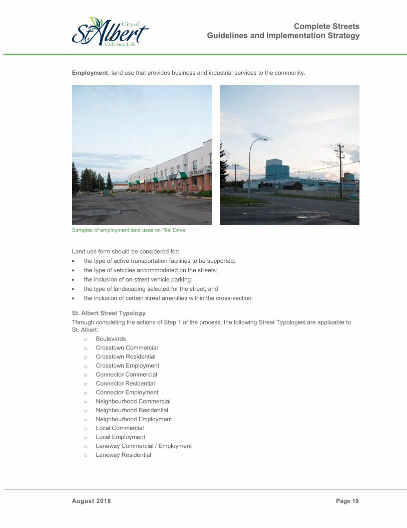
Employment: land use that provides business and industrial services to the community.
Samples of employment land uses on Riel Drive
Land use form should be considered for: the type of active transportation facilities to be supported; the type of vehicles accommodated on the streets; the inclusion of on-street vehicle parking; the type of landscaping selected for the street; and the inclusion of certain street amenities within the cross-section. St. Albert Street Typology Through completing the actions of Step 1 of the process, the following Street Typologies are applicable to St. Albert:
o Boulevards o Crosstown Commercial o Crosstown Residential o Crosstown Employment o Connector Commercial o Connector Residential o Connector Employment o Neighbourhood Commercial o Neighbourhood Residential o Neighbourhood Employment o Local Commercial o Local Employment o Laneway Commercial / Employment o Laneway Residential

Complete Streets Guidelines and Implementation Strategy
Page 20 August 2018
Step 2: Zones
Following completion of Step 1, and establishing the roadway function and the land use form, the next step involves dividing the roadway cross-section into zones based on the needs of the roadway function and the land use form. All streets are comprised of three distinct areas, with each area comprised of several distinct zones that help the street to function as a whole. Shown on Figure 4.3.
Figure 4.3: Complete Street Zones
1) Pedestrian Realm
o Influenced primarily by the adjacent land use. o Incorporates the:
Frontage Zone: In an urban mixed-use context, this space is an extension of the adjacent land use. Uses can include ground floor retail displays, café seating, retail signage and landscaping, and other activities that support the people and businesses who use the street. In a semi-urban context this space can be used to tie into the adjacent property landscaping. Through Zone: This area is intended to accommodate active transportation modes such as walking and cycling. This area should be free of obstructions to support mobility challenged users. In high-traffic pedestrian areas, separated cycling facilities should be provided to avoid pedestrian-cyclist conflicts in the through zone. Furnishing Zone: This area is intended to support the street furniture such as light standards, signage, transit stops, seating amenities, and landscaping. This space can also be used for snow storage or low impact development drainage opportunities.

Complete Streets Guidelines and Implementation Strategy
August 2018 Page 21
2) Interstitial Realm o Influenced primarily by both the land use for and the roadway function. o Incorporates the:
Curb Zone: This is space for the curb and gutter to allow surface drainage to be collected. The space can also be used for green infrastructure, or for traffic calming purposes through the use of curb extensions or chicanes.
Ancillary Zone: This zone is located within the interstitial area. The use of the space depends on the land use form and roadway function. The space can be used for on-street vehicle parking, transit loading zone or bus bay, bicycle parking, for seating, or for public art. For some land use forms and roadway functions, this space may not be required. At intersections, this space may be used for vehicle right-turn lanes.
3) Vehicle Realm
o Influenced primarily by the roadway function. o Vehicle Zone: The roadway space can be used for travel lanes for multiple modes of
transportation depending on the land use form and roadway function. These lanes could be for vehicles, buses, trucks, light rail vehicles, or bicycles.
o Bicycle Zone: Dedicated on-street cycling facilities are located in this zone. The space also includes buffer space or physical buffers in between parking or travel lanes.
A fourth area, the median area, may or may not exist, pending the type and design of the roadway. 4) Median
o This space can be used for landscaping or for vehicle left-turn lanes and is not required for every type of roadway function.
Breaking down the roadway cross-section into the distinct realms and further into the zones, allows for consideration of the context for each of the zones. From these zones, any possible cross-section can be imagined, following the key goals and objectives of Complete Streets to which each mode of transportation included is provided with safe facilities. Step 3: Elements
At this step, consideration is given to the specific elements within each zone. Elements within the zones may be different for each land use form and roadway function, and some may not be applicable in certain scenarios. For example, the size of the sidewalk, or the type of street amenities required, or the use of the ancillary zone will depend on the specific context. Section 6 of the Guidelines identifies additional considerations for design elements related to the following topics: Travel lanes Pedestrian and Public Realm Cycling Transit Design considerations for intersections, safe systems, and utilities are also shared in Section 6.

Complete Streets Guidelines and Implementation Strategy
Page 22 August 2018
Step 4: Trade-offs
No street has unlimited right-of-way available and accommodating all modes of transportation must be balanced effectively while being efficient with space. The elements and zones identified for the typologies must fit within an acceptable width of right-of-way and there are trade-offs associated with increasing or decreasing space provided to the elements or zones. Identifying and addressing trade-offs is a difficult but necessary step in arriving at a final cross-section. Differing values across a wide range of people using a corridor leads to different priorities, some of which may conflict or negatively impact one another. The key principles and objectives of Complete Streets influenced the final cross-sections and recommended space allocation within these Guidelines. Section 7 shares more detailed information on addressing trade-offs, including: The trade-offs made while developing cross-sections for St. Albert’s Street Typologies. How to address trade-offs arising as a result of retro-fitting St. Albert’s existing streets with the
Complete Streets philosophy. Step 5: Finalize Cross-section
Once trade-offs have been identified and addressed, the roadway cross-section is ready to be finalized. The cross-section should be reviewed as a whole system to ensure that it will meet the needs of all users and serves the original intended purpose.

Complete Streets Guidelines and Implementation Strategy
August 2018 Page 23
5.0 St. Albert’s Street Typology and Cross-sections
The following table provides guidance using the roadway function and land use form to equate to a Complete Street typology that will effectively serve the network and users of St. Albert.
Table 5.1: St. Albert Complete Streets Typologies
TAC ROADWAY FUNCTION
LAND USE FORM Commercial Residential Employment
Highways/ Expressways Boulevards
Divided Arterials Crosstown Commercial Crosstown Residential Crosstown Employment
Undivided Arterials Connector Commercial Connector Residential Connector Employment
Collectors Neighbourhood Commercial
Neighbourhood Residential
Neighbourhood Employment
Locals - Local Residential Local Employment
Laneways Laneway Commercial Laneway Residential Laneway Employment
The Complete Streets typology network for the City of St. Albert is shown on Figure 5.1.

Complete Streets Guidelines and Implementation Strategy
Page 24 August 2018
Figure 5.1: St. Albert Typology Street Network
The following are descriptions of the Typologies represented within the St. Albert Transportation network. Applications of this network are to provide context towards new roadway segments or expansion of existing roadway corridors. It should also be considered and appropriately applied during capital work to the existing network and integration of Complete Streets during any retro-fitting style project. Please refer to Section 7.3 for information associated with retro-fitting the existing network.

Complete Streets Guidelines and Implementation Strategy
August 2018 Page 25
5.1 Boulevards
Boulevards are regional streets that support the Edmonton Metropolitan Region, serving both local and regional traffic. They can have urban or rural cross-sections and may be challenging to design using standard cross-sections due to: The design of a boulevard impacts a larger number of residents and the design process must include inputs from all users of the corridor. These streets span longer distances than all other streets in the City and a single set of standards may not be implementable over the entire stretch of the
corridor. Boulevards may stretch across multiple jurisdictions and as such may be impacted by the design considerations and/or regulations of other municipalities
or jurisdictional authorities. Boulevards may be the preferred alignment for higher order transit for a region and would need to take those designs into consideration. Right of Way 45.0m or larger
Landscaping Three rows of landscape plantings
Active Mode Infrastructure Can accommodate sidewalks, multi-use trails, or protected bike lanes
Operational Considerations Accommodates public transit buses Accommodates commercial / large loads
Vehicle Infrastructure 3.5m lanes – two or more in each direction
Speed Limit Determined by traffic volumes and access frequency This street can be designed 10km/h above the intended posted speed limit
Median 4.3m center median, which can accommodate a 1.2m nose and a 3.1m
turn lane at intersections

Complete Streets Guidelines and Implementation Strategy
Page 26 August 2018
Example of a 45m Boulevard, Before and After LRTConstruction

Complete Streets Guidelines and Implementation Strategy
August 2018 Page 27
5.2 Crosstown Commercial
Crosstown commercial streets serve city-wide traffic while providing access to commercial and mixed-use destinations within the city. Cyclists are accommodated using separated cycling facilities, providing the highest level of safety. The bike lanes are provided on all types of crosstown streets to provide a continuous city-wide cycling network. In a commercial context with increased pedestrian activity, the bike lanes also help to limit pedestrian-cyclist interactions. On-street vehicle parking is included for access to street-fronting commercial properties.
Right of Way 38.0m
Landscaping Three rows of landscape plantings
Active Mode Infrastructure 2.2m sidewalk on both sides of the street 2.1m uni-directional bike lane on both sides of the street
Operational Considerations Accommodates public transit buses Accommodates commercial / large loads
Vehicle Infrastructure 3.5m lanes – two in each direction Supports on-street parking
Speed Limit 50km/h-60km/h This street should be designed to the intended posted speed limit
Median 4.3m center median, which can accommodate a 1.2m nose and a 3.1m
turn lane at intersections

Complete Streets Guidelines and Implementation Strategy
Page 28 August 2018
5.3 Crosstown Residential
Crosstown residential streets serve city-wide traffic while providing access to residential destinations within the city. Cyclists are accommodated using separated cycling facilities, providing the highest level of safety. The bike lanes are provided on all types of crosstown streets to provide a continuous city-wide cycling network.
Right of Way 38.0m
Landscaping Three rows of landscape plantings
Active Mode Infrastructure 2.2m sidewalk on both sides of the street 2.1m uni-directional bike lane on both sides of the street
Operational Considerations Accommodate public transit buses Accommodates commercial / large loads
Vehicle Infrastructure 3.5m lanes – two in each direction
Speed Limit 50km/h-60km/h This street should be designed to the intended posted speed limit
Median 4.3m center median, which can accommodate a 1.2m nose and a
3.1m turn lane at intersections

Complete Streets Guidelines and Implementation Strategy
August 2018 Page 29
5.4 Crosstown Employment
Crosstown employment streets serve city-wide traffic while providing access to employment destinations within the city. Cyclists are accommodated using separated cycling facilities, providing the highest level of safety. The bike lanes are provided on all types of crosstown streets to provide a continuous city-wide cycling network.
Right of Way 38.0m
Landscaping Three rows of landscape plantings
Active Mode Infrastructure 2.2m sidewalk on both sides of the street 2.1m uni-directional bike lane on both sides of the street
Operational Considerations Accommodate public transit buses Accommodates commercial / large loads
Vehicle Infrastructure 3.5m lanes – two in each direction
Speed Limit 50km/h-60km/h This street should be designed to the intended posted speed limit
Median 4.3m center median, which can accommodate a 1.2m nose and a 3.1m
turn lane at intersections

Complete Streets Guidelines and Implementation Strategy
Page 30 August 2018
5.5 Connector Commercial
Connector commercial streets are major streets in a commercial and mixed-use land use context that typically connect crosstowns together. Due to a higher volume of pedestrians expected as a result of the commercial context, dedicated cycling facilities are provided for this typology.
Right of Way 31.0m
Landscaping Two rows of landscape plantings
Active Mode Infrastructure 2.2m sidewalk on both sides of the street 2.1m uni-directional bike lane on both sides of the street
Operational Considerations Accommodates public transit buses May accommodate commercial / large loads, not typically a truck route
Vehicle Infrastructure 3.5m lanes – one in each direction Supports on-street parking
Speed Limit 50km/h This street should be designed to the intended posted speed limit
Median 3.4m space for a mid-block turn lane or landscaping (if required)

Complete Streets Guidelines and Implementation Strategy
August 2018 Page 31
5.6 Connector Residential
Connector residential streets are major streets in a residential land use context that typically connect crosstowns together. A multi-use trails are provided for cyclists and pedestrians on these streets.
Right of Way 27.0m
Landscaping Two rows of landscape plantings
Active Mode Infrastructure 3.0m multi-use trail on both sides of the street
Operational Considerations Accommodates public transit buses May accommodate commercial / large loads, not typically a truck route
Vehicle Infrastructure 3.5m lanes – one in each direction
Speed Limit 50km/h This street should be designed to the intended posted speed limit
Median 4.0m space for a mid-block turn lane or landscaping (if required)

Complete Streets Guidelines and Implementation Strategy
Page 32 August 2018
5.7 Connector Employment
Connector employment streets are major streets in an employment land use context that typically connect crosstowns together. A multi-use trails are provided for cyclists and pedestrians on these streets.
Right of Way 25.0m
Landscaping Two rows of landscape plantings
Active Mode Infrastructure 3.0m multi-use trail on both sides of the street
Operational Considerations Accommodates public transit buses Accommodates commercial / large loads
Vehicle Infrastructure 3.5m lanes – one in each direction
Speed Limit 50km/h This street should be designed to the intended posted speed limit
Median 4.0m space for a mid-block turn lane or landscaping (if required)

Complete Streets Guidelines and Implementation Strategy
August 2018 Page 33
5.8 Neighbourhood Commercial
A neighbourhood commercial street is a minor street which provides access to street-fronting commercial and mixed-use developments. They are capable of accommodating transit and include wide sidewalks that allow for shared use between pedestrians and cyclists. These streets may also accommodate cyclists in the travel lanes for the short spans that then connect to the trail system or larger road system that further accommodates cyclists.
Right of Way 22.0m
Landscaping Two rows of landscape plantings
Active Mode Infrastructure 2.2m sidewalk on both sides of the street
Operational Considerations Accommodates public transit buses Does not typically accommodate commercial / large loads
Vehicle Infrastructure 3.5m lanes – one in each direction Supports on-street parking
Speed Limit 30km/h-50km/h This street should be designed to the intended posted speed limit

Complete Streets Guidelines and Implementation Strategy
Page 34 August 2018
5.9 Neighbourhood Residential
A neighbourhood residential street is a minor street which provides access to street-fronting residential developments. They are capable of accommodating transit and include wide sidewalks that allow for shared use between pedestrians and cyclists. These streets may also accommodate cyclists in the travel lanes for the short spans that then connect to the trail system or larger road system that further accommodates cyclists.
Right of Way 22.0m
Landscaping Two rows of landscape plantings
Active Mode Infrastructure 2.2m sidewalk on both sides of the street
Operational Considerations Accommodates public transit buses Does not accommodate commercial / large loads
Vehicle Infrastructure 3.5m lanes – one in each direction Supports on-street parking
Speed Limit 30km/h-50km/h This street should be designed to the intended posted speed limit

Complete Streets Guidelines and Implementation Strategy
August 2018 Page 35
5.10 Neighbourhood Employment
A neighbourhood employment street is a minor street which provides access to street-fronting employment developments. They are capable of accommodating transit and include wide sidewalks that allow for shared use between pedestrians and cyclists. These streets may also accommodate cyclists in the travel lanes for the short spans that then connect to the trail system or larger road system that further accommodates cyclists.
Right of Way 22.0m
Landscaping Two rows of landscape plantings
Active Mode Infrastructure 2.2m sidewalk on both sides of the street
Operational Considerations Accommodates public transit buses Accommodates commercial / large loads
Vehicle Infrastructure 3.5m lanes – one in each direction Supports on-street parking
Speed Limit 30km/h-50km/h This street should be designed to the intended posted speed limit

Complete Streets Guidelines and Implementation Strategy
Page 36 August 2018
5.11 Local Residential
A local residential street is a minor street that provides direct access from the front of a residential development. Separate cycling facilities are not part of the local residential cross-section as lower vehicle volumes and speeds and reduced pedestrian volumes allow for cyclists to use either the sidewalk or vehicle travel lanes to connect to the community trail system or larger road network. These streets do not accommodate transit buses.
Right of Way 18.0m
Landscaping Two rows of landscape plantings
Active Mode Infrastructure 1.8m sidewalk on both sides of the street
Operational Considerations Do not accommodate public transit buses Do not accommodate commercial / large loads
Vehicle Infrastructure 4.2m bi-directional lane Supports on-street parking
Speed Limit 20km/h-30km/h This street should be designed to the intended posted speed limit

Complete Streets Guidelines and Implementation Strategy
August 2018 Page 37
5.12 Local Employment
A local employment street is a minor street that provides direct access from the front of an employment development. Separate cycling facilities are not part of the local residential cross-section as lower vehicle volumes and speeds and reduced pedestrian volumes allow for cyclists to use either the sidewalk or vehicle travel lanes to connect to the community trail system or larger road network. These streets typically do not serve public transit, although they can accommodate transit buses.
Right of Way 18.0m
Landscaping Two rows of landscape plantings
Active Mode Infrastructure 1.8m sidewalk on both sides of the street
Operational Considerations Accommodate commercial / large loads
Vehicle Infrastructure 4.5m lanes – one in each direction
Speed Limit 20km/h-30km/h This street should be designed to the intended posted speed limit

Complete Streets Guidelines and Implementation Strategy
Page 38 August 2018
5.13 Laneway Commercial / Employment
These streets provide rear access to commercial and employment developments.
Right of Way 6.0m Vehicle Infrastructure 6.0m bi-directional lane Speed Limit <20km/h This street should be designed to the intended posted speed
limit
5.14 Laneway Residential
These streets provide rear access to residential developments.
Right of Way 7.0m Vehicle Infrastructure 4.0m bi-directional lane Speed Limit <20km/h This street should be designed to the intended posted speed
limit

Complete Streets Guidelines and Implementation Strategy
August 2018 Page 39
6.0 Elements
Street cross-sections can be broken down into three realms; the pedestrian realm, the interstitial realm, and the vehicle realm, plus another area which may include a median. The realms can be broken further into different zones, each serving specific functions. For example, the bike zone within the vehicle realm is a space dedicated to serving cycle traffic. Within, the bike zone, there are several different types of cycling facilities that can be selected; multi-use trails, painted bike lanes, buffered bike lanes, or protected bike lanes. These different types of facilities are referred to as elements and each serve the same purpose but with varying levels of safety and convenience. In the sub-sections below, elements are categorised into the following areas:
Vehicle Realm – design considerations for travel lanes, turning lanes, and parking lanes Pedestrian Realm – design considerations for elements within the frontage, through, and furnishing
zones Cycling – design considerations for cycling infrastructure elements Transit – design considerations for transit amenities and transit vehicles Guidelines for Intersections – design considerations for curb radii and bike lanes at intersections Speeds and Safe Systems – the link between speeds and safe transportation systems Utilities – design considerations for utility placements within cross-sections
Rendering of Elements Creating a Complete Street for all Users
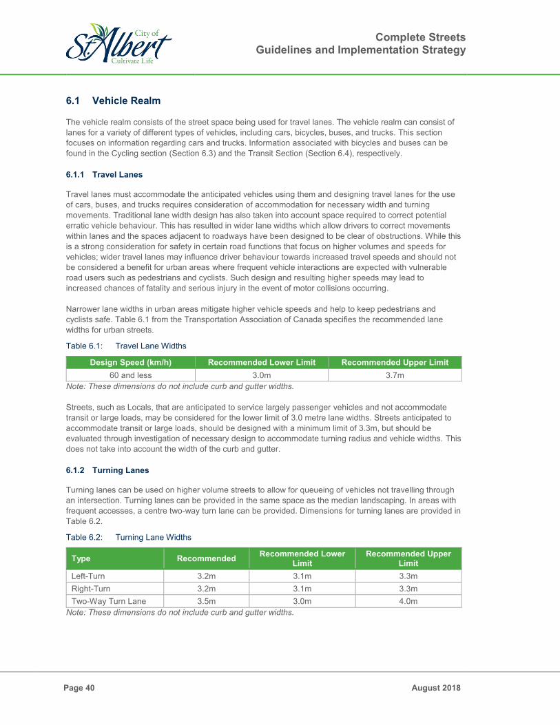
Complete Streets Guidelines and Implementation Strategy
Page 40 August 2018
6.1 Vehicle Realm
The vehicle realm consists of the street space being used for travel lanes. The vehicle realm can consist of lanes for a variety of different types of vehicles, including cars, bicycles, buses, and trucks. This section focuses on information regarding cars and trucks. Information associated with bicycles and buses can be found in the Cycling section (Section 6.3) and the Transit Section (Section 6.4), respectively. 6.1.1 Travel Lanes
Travel lanes must accommodate the anticipated vehicles using them and designing travel lanes for the use of cars, buses, and trucks requires consideration of accommodation for necessary width and turning movements. Traditional lane width design has also taken into account space required to correct potential erratic vehicle behaviour. This has resulted in wider lane widths which allow drivers to correct movements within lanes and the spaces adjacent to roadways have been designed to be clear of obstructions. While this is a strong consideration for safety in certain road functions that focus on higher volumes and speeds for vehicles; wider travel lanes may influence driver behaviour towards increased travel speeds and should not be considered a benefit for urban areas where frequent vehicle interactions are expected with vulnerable road users such as pedestrians and cyclists. Such design and resulting higher speeds may lead to increased chances of fatality and serious injury in the event of motor collisions occurring. Narrower lane widths in urban areas mitigate higher vehicle speeds and help to keep pedestrians and cyclists safe. Table 6.1 from the Transportation Association of Canada specifies the recommended lane widths for urban streets.
Table 6.1: Travel Lane Widths
Design Speed (km/h) Recommended Lower Limit Recommended Upper Limit 60 and less 3.0m 3.7m
Note: These dimensions do not include curb and gutter widths. Streets, such as Locals, that are anticipated to service largely passenger vehicles and not accommodate transit or large loads, may be considered for the lower limit of 3.0 metre lane widths. Streets anticipated to accommodate transit or large loads, should be designed with a minimum limit of 3.3m, but should be evaluated through investigation of necessary design to accommodate turning radius and vehicle widths. This does not take into account the width of the curb and gutter. 6.1.2 Turning Lanes
Turning lanes can be used on higher volume streets to allow for queueing of vehicles not travelling through an intersection. Turning lanes can be provided in the same space as the median landscaping. In areas with frequent accesses, a centre two-way turn lane can be provided. Dimensions for turning lanes are provided in Table 6.2.
Table 6.2: Turning Lane Widths
Type Recommended Recommended Lower Limit
Recommended Upper Limit
Left-Turn 3.2m 3.1m 3.3m Right-Turn 3.2m 3.1m 3.3m Two-Way Turn Lane 3.5m 3.0m 4.0m
Note: These dimensions do not include curb and gutter widths.

Complete Streets Guidelines and Implementation Strategy
August 2018 Page 41
6.1.3 On-Street Parking Lanes
Parking lanes that accommodate on-street parking, are considered part of the interstitial area in between the vehicle realm and the public realm. It is not common to accommodate on-street parking along roadways such as Crosstowns and Connectors. Exceptions may be considered in commercial land use forms where the adjacent development may benefit from on-street vehicle parking. At Neighbourhood and Local roadway functions, vehicle parking is typically provided, with the possible exception being local employment streets.
Table 6.3: Parking Lane Widths
Type Recommended Recommended Lower Limit
Recommended Upper Limit
Parallel 2.4m 2.3m 2.6m Note: The dimensions include the curb and gutter.
On-street parking along Tache Street

Complete Streets Guidelines and Implementation Strategy
Page 42 August 2018
6.2 Pedestrian Realm
The pedestrian realm consists of the space in between the interstitial area and the property line of developments. This space has the potential to serve the most amount of uses out of the three major areas in streets. The space within the pedestrian realm is further divided into three zones: the frontage zone, the through zone, and the furnishing zone. 6.2.1 Frontage Zone
The frontage zone may serve multiple purposes: Space for building doors Business signage and landscaping Café or restaurant seating Table 6.4 shows recommended lower and upper limits for the frontage zone. Door zones, signage, and landscaping can be accommodated by the lower limit. However, for seating in the frontage zone, at least 1.0m is required. The use of the frontage zone depends on the land use form. In commercial land use forms, the space is able to serve multiple purposes.
Table 6.4: Frontage Zone Widths
Land Use Form Recommended Lower Limit Recommended Upper Limit Commercial Areas Residential / Employment Areas
0.5m 0.3m
3.0m 2.0m
Passing open spaces, where the frontage zone is not required, space can be allocated to additional amenities such as landscaping or pedestrian resting areas.
Benches and landscaping along Riel Drive where a traditional frontage zone is not required
Pedestrian realm zones on Perron Street

Complete Streets Guidelines and Implementation Strategy
August 2018 Page 43
6.2.2 Through Zone
Through zone space is intended to be a clear space used for pedestrian travel. The following figures display common dimensions to accommodate different types of pedestrians. Special consideration in safety and space must be made to this zone to acknowledge that St. Albert bylaws support cyclists using the sidewalk.
Pedestrians in the through zone in downtown St. Albert
Typical Pedestrian Dimensions Horizontal Operating Envelope for a Person with a Service Animal
Wheelchair User Dimensions
Figure 6.1: Typical Pedestrian Dimensions (Source: 2017 TAC Geometric Design Guide for Canadian Roads: Pedestrian Integrated Design)
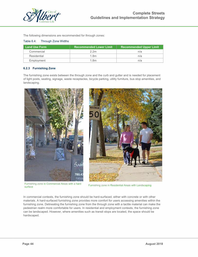
Complete Streets Guidelines and Implementation Strategy
Page 44 August 2018
The following dimensions are recommended for through zones:
Table 6.4: Through Zone Widths
Land Use Form Recommended Lower Limit Recommended Upper Limit Commercial 2.2m n/a Residential 1.8m n/a Employment 1.8m n/a
6.2.3 Furnishing Zone
The furnishing zone exists between the through zone and the curb and gutter and is needed for placement of light posts, seating, signage, waste receptacles, bicycle parking, utility furniture, bus stop amenities, and landscaping.
Furnishing zone in Commercial Areas with a hard surface Furnishing zone in Residential Areas with Landscaping
In commercial contexts, the furnishing zone should be hard-surfaced, either with concrete or with other materials. A hard-surfaced furnishing zone provides more comfort for users accessing amenities within the furnishing zone. Delineating the furnishing zone from the through zone with a tactile material can make the pedestrian realm more comfortable for users. In residential and employment contexts, the furnishing zone can be landscaped. However, where amenities such as transit stops are located, the space should be hardscaped.

Complete Streets Guidelines and Implementation Strategy
August 2018 Page 45
Table 6.5: Furnishing Zone Widths
Land Use Form Recommended Lower Limit Recommended Upper Limit Commercial 1.8m 3.0m Residential 2.2m 3.5m Employment 2.2m 3.5m
Landscaping
One component of the furnishing zone is an area dedicated for landscaping. A key consideration is the use of the space for tree placement in all typologies.
Hardscaped narrow furnishing zones will need structural soil cells to accommodate healthy trees
Landscaped wide furnishing zones do not required soil cells to accommodate healthy trees
In hard-surfaced commercial areas with soil cell placement and tree grates, a 2.2m width or more is preferred to provide soil volumes adequate for healthy root growth. The minimum width of 1.8m may be applied on a case by case basis where constraints have been evaluated to best be addressed through the trade off of reduced landscaping zone. In residential and employment land use forms, a 2.5m width provides adequate soil volumes for tree growth. A minimum of 2.2 may be used on a case-by-case basis in constrained conditions.

Complete Streets Guidelines and Implementation Strategy
Page 46 August 2018
Bus Stop
The standard width for bus stop pads with a bench or a shelter is 2.5m in St. Albert. A bus pad with a connection to the sidewalk should be provided at all bus stops. In commercial cross-sections where the furnishing zone is not wide enough for a 2.5m bus pad, a curb bulb-out should be used in place of curb parking for the length of the bus stop. This also allows transit vehicles to use the travel lane as a transit zone, avoiding having to pull into and out of parking spaces. Refer to Section 6.4 for more information about transit accommodation.
Bus stop on Sir Winston Churchill Avenue
Utilities
Although most utilities are located underground within the City of St. Albert, complete streets design must still take into account surface features such as transformer boxes within the furnishing zones. Refer to Section 6.8 for more information on utility accommodation.
Utility box located within the furnishing zone

Complete Streets Guidelines and Implementation Strategy
August 2018 Page 47
6.3 Cycling
If considered during roadway planning and design, cycling facilities may offer a safe and convenient alternative to vehicles to travel through and within any city. Traditional street design has often overlooked the needs of cyclists, with accommodation typically provided through shared space with pedestrians, on sidewalks or multi-use trails, or shared with vehicles in shared lanes. There are many different types of cyclists, each with a different need from the roadway environment, ability level, and expectation of accommodation. Where shared space with pedestrians or with vehicles does not meet the needs of all cyclists, dedicated cycling facilities provide a safer and more convenient infrastructure type to support and encourage a wider range of cyclists. 6.3.1 Sidewalk Use
Shared sidewalk space between cyclists and pedestrians can be both inconvenient for passing and at times very unsafe. Consideration is made towards the adjacent land use, anticipated demand, and expected ability of the cyclist within different scenarios. Optimally a 2.2 m to 3.0 m width is provided in cases where shared space is designed; however, on local streets, where both cyclists and pedestrians would spend a short portion of their trip, a 1.8m width may be acceptable. On crosstown and connector streets, due to longer travel sections, potential of higher volumes and higher travel speeds, dedicated cycling facilities should be provided. It is worth noting that cycling is permitted on all sidewalks within St. Albert.
Cyclist on the sidewalk of St. Anne Street

Complete Streets Guidelines and Implementation Strategy
Page 48 August 2018
6.3.2 Multi-use trails
While multi-use trails are wider then sidewalks and may be more convenient for cyclists to pass and share space with pedestrians in low volume areas; where higher pedestrian traffic exists, the shared space remains inconvenient and potentially unsafe. Share-use paths may be applied in residential or employment land forms, where additional considerations of space may result in constraints to accommodating dedicated on-street cycling facilities.
Table 6.6: Multi-use Trail Widths
Type Recommended Lower Limit Recommended Upper Limit Multi-use trail 3.0m 6.0m
6.3.3 Shared Lanes
Shared lanes between cyclists and vehicles marked with “sharrows”, provide a wider space for cyclists; however, most cyclists do not feel comfortable sharing space with vehicles. Consideration of this facility should only be provided in traffic-calmed streets with vehicle speeds below 30km/h and specifically designed under site context and conditions. Shared lanes can be designed to operate for side-by-side operation or single file operation. An illustration of shared lanes can be seen on the next page.
Existing Multi-use Trail on Sir Winston Churchill Avenue
Shared Lane on 81 Avenue in Edmonton

Complete Streets Guidelines and Implementation Strategy
August 2018 Page 49
Figure 6.2: Shared Lanes (Source: Geometric Design Guide for Canadian Roads – Chapter 5: Bicycle Integrated Design)
The table below displays the recommended widths for shared lanes.
Table 6.7: Shared Lane Widths
Component Recommended Lower Limit Recommended Upper Limit Side-by-side operation 4.3m 4.9m Single file operation Lane width 4.0m
Additional considerations for shared lanes include: If the shared lane for side-by-side operation is adjacent to parking, a lane width closer to the upper limit
should be selected. A shared lane bicycle facility should not be selected for a lane width larger than 4.9m; this may result in
two vehicles operating side-by-side

Complete Streets Guidelines and Implementation Strategy
Page 50 August 2018
6.3.4 Dedicated Cycling Facilities
Dedicated space removes conflict between road users. For cyclists, a separated area could support travel at a pace that is comfortable without having to worry about slowing down for pedestrians or speeding up for vehicles. The following sub-sections share considerations and recommended lower and upper limits for several dedicated cycling facilities. Bike Lanes
Bike lanes provide on-street space for cyclists, separated from vehicle or parking lanes with paint stripes. These bike lanes are also referred to as un-buffered bike lanes, or Type II bike facilities. TAC’s Geometric Design Guide illustrates the layout of bike lanes. This type of bike lane should only be used in scenarios that have constrained space and on streets with low traffic volumes and lower expected percentage of trucks. This facility type is not appropriate for Crosstown and Connector streets; a separated facility should be used instead.
Figure 6.3: Bike Lanes (Source: Geometric Design Guide for Canadian Roads – Chapter 5: Bicycle Integrated Design)
Table 6.8: Bike Lane Widths
Type Recommended Lower Limit Recommended Upper Limit Bike Lane 1.8m 2.1m
Bike Lane on 121 Street in Edmonton

Complete Streets Guidelines and Implementation Strategy
August 2018 Page 51
Buffered Bike Lanes
Buffered bike lanes provide on-street space for cyclists, separated from vehicle travel lanes or parking lanes by a buffer marked out with paint. TAC’s Geometric Design Guide illustrates the layout of buffered bike lanes. Buffered bike lanes can be used on neighbourhood streets. However, where possible a protected bike lane should be used instead.
Figure 6.4: Buffered Bike Lanes (Source: Geometric Design Guide for Canadian Roads – Chapter 5 – Bicycle Integrated Design)
Table 6.9: Buffered Bike Lane Widths
Component Recommended Lower Limit Recommended Upper Limit Buffered Bike Lane 1.8m 2.1m Buffer 0.3m 0.9m Total 2.1m 3.0m
Note: Adjacent to a parking lane, a buffer of at least 0.6m should be used.
Buffered bike lane on 106 Avenue, Edmonton

Complete Streets Guidelines and Implementation Strategy
Page 52 August 2018
Protected Bike Lanes
Protected bike lanes provide uni-directional or bi-directional on-street space for cyclists, separated from vehicle or parking lanes with a protected median. TAC’s Geometric Design Guide illustrates the layout of these types of bike lanes.
Uni-directional Protected Bike Lane on 106 Street in Edmonton
Figure 6.5: Uni-directional Protected Bike Lanes (Source: Geometric Design Guide for Canadian Roads – Chapter 5 – Bicycle Integrated Design)

Complete Streets Guidelines and Implementation Strategy
August 2018 Page 53
Bi-directional Protected Bike Lane on 102 Avenue in Edmonton
Figure 6.6: Bi-directional Protected Bike Lanes (Source: Geometric Design Guide for Canadian Roads – Chapter 5 – Bicycle Integrated Design)

Complete Streets Guidelines and Implementation Strategy
Page 54 August 2018
Table 6.10 displays the recommended widths for protected bike lanes.
Table 6.10: Protected Bike Lane Widths
Component Recommended Lower Limit Recommended Upper Limit Protected Bike Lane – Unidirectional
1.8m 2.5m
Protected Median 0.3m 1.0m Total 2.1m 3.5m Protected Bike Lane – Bidirectional
3.0m 3.6m
Protected Median 0.3m 1.0m Total 3.3m 4.6m
Note: Adjacent to a parking lane, a buffer of at least 0.6m should be used. Where possible, protected bike lanes should be used to support safe and convenient travel for the widest range of cycling abilities. Primary City-Wide Cycle Routes on Crosstown streets must be protected bike lanes. 6.3.5 Bicycle Parking
An important aspect of cycling infrastructure is bicycle parking. A lack of spaces to lock bicycles at the end of trips makes cycling less convenient. Bicycle parking should be provided in spaces which are in close proximity to the front doors of buildings. To prevent theft, parking should be place in locations which are highly visible to the maximum amount of people.
Bike parking on St. Joseph Street Bike locker at King’s University, Edmonton
For longer-term parking, bicycle lockers can protect against theft, vandalism, and inclement weather. This type of bicycle parking is especially important for multi-modal trips requiring transfer at transit centres or stations.

Complete Streets Guidelines and Implementation Strategy
August 2018 Page 55
6.4 Transit
6.4.1 Transit Users
Transit services can be greatly supported through a well planned and designed transportation network. Acknowledging and supporting connectivity between all modes, routing to maximize efficiency, appropriate spacing for reduced travel distances to and from transit stops and the provision of safe and accessible infrastructure will assist in supporting and encouraging transit use. In the context of Complete Streets, the needs of transit users are met through two types of infrastructure:
Sidewalks and curb ramps – for connectivity and access to bus stops
Bus Stop Amenities – for a comfortable experience while waiting for a bus Sidewalks and Curb Ramps
Bus Stops must be connected to the larger transportation network through sidewalks or trails and must be made fully accessible for all mobility ranges through the placement of pedestrian curb ramps. Missing sidewalks and curb ramps act as barriers for mobility and may force people into vehicle lanes or onto landscaping areas, which may present both safety and accessibility issues. Wheelchairs, scooters, and walkers do not have the ability to traverse landscaping or the ability to access a sidewalk if there is no curb ramp provided. Visually-impaired individuals require a clear space free of any obstacles and can be assisted through directional curb ramps that provide indications for safe travel.
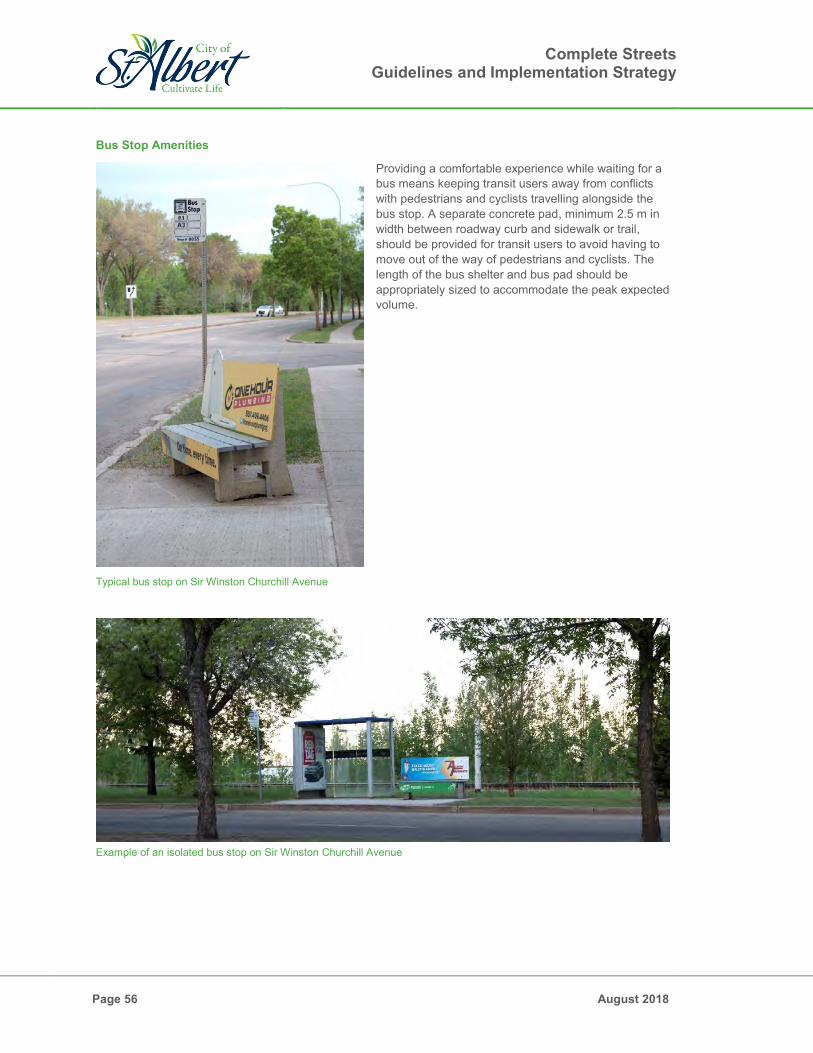
Complete Streets Guidelines and Implementation Strategy
Page 56 August 2018
Bus Stop Amenities
Providing a comfortable experience while waiting for a bus means keeping transit users away from conflicts with pedestrians and cyclists travelling alongside the bus stop. A separate concrete pad, minimum 2.5 m in width between roadway curb and sidewalk or trail, should be provided for transit users to avoid having to move out of the way of pedestrians and cyclists. The length of the bus shelter and bus pad should be appropriately sized to accommodate the peak expected volume.
Example of an isolated bus stop on Sir Winston Churchill Avenue
Connected bus pad on Sir Winston Churchill Avenue
Typical bus stop on Sir Winston Churchill Avenue

Complete Streets Guidelines and Implementation Strategy
August 2018 Page 57
To avoid conflict with bus stops adjacent to dedicated on-street cycling facilities, the following changes can be made: The cycle lane can be raised flush with the protected median and the bus pad for the length of the bus
pad so pedestrians can travel from the bus pad in the furnishing zone towards the bus doors on the other side of the protected median. Cyclists should yield to pedestrians for the length of the bus pad. If the nearest lane is a parking lane, then a curb extension should be used for transit users to access the bus doors.
The cycle lane can be traversed so it switches positions with the bus pad for the length of the pad. In this scenario the bike lane and protected median would be placed in between the through zone and the bus pad. The bike lane can be raised so it is flush with the through zone and bus pad. The bike lane could also remain at the roadway surface elevation with curb ramps on either side for pedestrian to cross in between the through zone and the bus pad. Cyclists should yield to pedestrians in this zone.
Bus stop near a protected bike lane in Edmonton

Complete Streets Guidelines and Implementation Strategy
Page 58 August 2018
6.4.2 Transit Vehicles
Consideration of needs of a transit vehicle in roadway design can also make the transit experiences more comfortable for users. Transit Zones Design
Transit Zones are places where transit passengers are received for transportation or delivered after transportation. Transit operations are impacted by constantly having to pull into separated transit zones for passenger boarding and alighting, and then merging back into travel lanes and traffic. To avoid this situation, transit zones should be in travel lanes. In areas where the travel lane and the bus pad are separated by a parking lane, a curb extension should be used to allow the bus to remain in the travel lane without having to pull into the parking lane. These considerations can positively impact travel time significantly which generated greater consistency and confidence of the system.
Rendering of a curb extension along a transit stop (Source: Proving to Caltrans That El Camino Real Can Be a Safer Street, by Andrew Boone) Bus Lane
Bus lanes provide priority for transit vehicles and improve travel time. A lane of traffic, typically the outside lane, is reserved for only transit vehicles. Table 6.10 shows recommended dimensions for bus lanes.
Table 6.11: Bus Lane Widths
Type Recommended Recommended Lower Limit
Recommended Upper Limit
Bus Lane 3.6m 3.4m 4.0m Note: These dimensions do not include curb and gutter widths.

Complete Streets Guidelines and Implementation Strategy
August 2018 Page 59
6.5 Summary of Elements by Typology
Table 6.12 summarizes the various elements accommodated within each of the typologies.
Table 6.12: Summary of Elements By Typology
Typology Boulevards Crosstown Connector Neighbourhood Local Lane
Adjacent Land Use All C R E C R E C R E R E All
Vehicle Accomodation
Passenger Vehicles
Large Trucks
Buses
Turning Lanes
Parking Lanes
Pedestrian Realm Amenities
Frontage Zone
Sidewalks
Multi-use Path
Cycling
Sidewalks
Multi-use Trail
Shared Lane
Buffered Bike Lane
Protected Bike Lanes
Furnishing Zone
Utilities *
Street Amenities
Bus Stops
Landscaping C – commercial R – residential E – employment * - Right-of-way can accommodate the installation of streetlights should they be required

Complete Streets Guidelines and Implementation Strategy
Page 60 August 2018
"This page intentionally left blank."

Complete Streets Guidelines and Implementation Strategy
August 2018 Page 61
6.6 Guidelines for Intersections
Complete intersections ensure that the safety of all users is being prioritized. Intersections are the most complex part of the transportation network and require very specific regulations and design to protect people making different movements. Curb Radii
Large curb radii allow traversing corners at higher speeds. Curb radii need to be designed to allow the largest typical vehicles on the roadway to turn comfortably; however, the radii need not be designed to allow vehicles to traverse the corner at speeds higher than 30 km/h. Smaller curb radii also improve the crossing distance for pedestrians and the queueing space available at the corner. Figure 6.7 from the TAC Geometric Design Guide illustrates the effects of corner radii on intersections.
Figure 6.7: Effect of Corner Radius on Pedestrian Crossing Distance and Directness
(Source: 2017 TAC Geometric Design Guide for Canadian Roads: Chapter 6 – Pedestrian Integrated Design)

Complete Streets Guidelines and Implementation Strategy
Page 62 August 2018
Protected Bike Lanes at Intersections
Protected bike lanes require additional consideration through intersections as it introduces another set of movements to regulate. Best practice for protected bike lanes is to provide protection through the intersection as well. At intersections, the parking and furnishing zones can be removed for a right-turn lane, and the bike lane should be in between the pedestrian realm and the right-turn lane. An example of this cross-section is shown in Figure 6.8.
Figure 6.8: Protected Bike Lanes at Intersections
The TAC Geometric Design Guide includes additional guidance on the design of protected intersections.
Figure 6.9: Protected Bike Lanes at Intersections
(Source: TAC Geometric Design Guide for Canadian Roads – Chapter 5: Bicycle Integrated Design)

Complete Streets Guidelines and Implementation Strategy
August 2018 Page 63
6.7 Speeds and Safe Systems
The City of St. Albert has developed a Transportation Safety Plan (2018) and has adopted the direction towards Vision Zero for improving road safety, where no serious injuries or fatalities should occur as a result of motor vehicle collisions. The Safety Plan documents a strategy to enhancing safety for all road users through a holistic approach using the “5 E’s” of traffic safety – Engineering, Education, Engagement, Enforcement and Evaluation. Complete Streets aligns to the City’s Transportation Safety Plan through the incorporation of greater consideration and safer street design for all modes of travel. A Safe Street Design approach recognizes that human behaviour and resulting errors may occur within the transportation network. Designing and building the network in recognition of human limits, knowing a person is fragile and can only withstand certain forces, is imperative to improving safety and designing roadways that shift towards a reduction of exposure or conflict, reduce speeds that may reduce collision occurrences and severity in the event they do occur, and shape roads that are safe for vulnerable road users. The interdisciplinary nature of Safe Street Design stresses the importance of traffic safety as not just a law enforcement and engineering issue, but equally as a public health and social equity concern. Vehicle Speeds A key component of Safe Street Design is reducing speeding. In North America, many roads were originally designed to maximize motor vehicle speed, which comes at the expense of the safety of other road users. It is well known, however, that driver speed has an adverse effect on likelihood of victim survival in the event of a collision. As shown on Figure 6.10, vehicles traveling at 50 kilometers per hour pose a far greater threat of pedestrian death than vehicles traveling at lesser speeds. In addition to these results of impact, the likelihood of a collision is increased because a driver’s peripheral vision greatly reduces at higher speeds.1 Another factor revolves around reaction time: driving on streets at a higher speed requires a longer stopping distance to be able to yield to a person crossing at a crosswalk, which puts pedestrians at a severe risk of death. Figure 6.10 provides the typical stopping distances of a traveling vehicle at various speeds, taking into account average reaction times and breaking distance on two different road conditions – dry and wet.
Figure 6.10: Probability of Fatal Injury for a Pedestrian after being struck by a Vehicle at Different Speeds
1 A. Bartmann, W. Spijkers and M. Hess (1991) “Street Environment, Driving Speed and Field of Vision” Vision in Vehicles III. As
cited in NACTO Urban Street Design Guide retrieved in May 2017 from https://nacto.org/publication/urban-street-design-
guide/design-controls/design-speed/

Complete Streets Guidelines and Implementation Strategy
Page 64 August 2018
The speed for which any roadway is designed (design speed) greatly impacts its risk for pedestrian injury. Designing streets to the intended posted speed limit contributes greatly to creating a safe system. Controlling speeds is vital to protecting street users such the elderly and children, especially around schools, playgrounds, senior centers, recreation centres, and public libraries. A street design philosophy which considers land use context is much more successful in creating streets which can be used by both the elderly and children.
Figure 6.11: Stopping Distances: Speed and Braking
(Source: The State of Queensland Government, Australia) In response to this research, some cities have challenged conventional engineering standards and have worked to redesign streets for lower speeds. Some approaches to tackle speeding that cities across the country have implemented include:
Neighbourhood Traffic Calming or Road Diets: narrowing lane widths, converting travel lanes to another use, shortening crossing distances, making crosswalks more visible, adding on-street parking and installing pedestrian and bicycle friendly infrastructure such as refuge islands, street trees, planted medians, bump-outs, curb extensions, speed humps/tables, protected bicycle lanes and automatic countdown signals with pedestrian advances.
Speed Limits: Lowering the default speed limit within a city.
Education: Public safety education and awareness campaigns.
Increased Traffic Enforcement: red light cameras, radar detection, and increased fines for speeding and failure to yield.

Complete Streets Guidelines and Implementation Strategy
August 2018 Page 65
Methodology
How does a City go about implementing a Safe Street Design Program? The first step is to make sure safety decisions are made based on data in order to channel limited resources to where they can do the most good. While this concept seems fundamental, in most places spending on safety is more reactive, being driving by citizen complaints or recent, high-profile incidents. The most successful programs use historical collision data to identify locations with the highest concentrations of fatal and severed injury collisions. When this data is cross-correlated with who is being hit, it is often found that children, the elderly, pedestrians and bicyclists have the greatest risk for fatal and serious injury collisions. Many communities also find that a preponderance of severe and fatal collisions occur on select, major streets and are caused by preventable driver behaviors (such as speeding or failure to yield). Mapping a High-Injury Network, using a variety of indicators – including severity, vulnerability, and social equity – a community can create a list of priorities and begin a series of low-cost physical design interventions and safety countermeasures to address key concerns. Some examples of countermeasures include: Installing leading pedestrian intervals at signalized intersections with known left turn conflicts; Improving crosswalk visibility through striping and intersection lighting; Installing protected bicycle lanes along corridors with high rates of bicycle-vehicle conflicts; and Increasing enforcement in areas with high rates of dangerous driving behavior (sometimes including red
light cameras and enforcement of misdemeanors like speeding and failing to yield). Retrofitting should be prioritized through an evidence based approach – using collision data, vehicle speed data, and pedestrian / cyclist count information. The city’s Transportation Safety Plan has been developed through an evidence based approach focusing on mitigation measures and strategies to reduce injuries and fatalities. For new development, planned and designed placement of traffic calming measures and designing the roadway for reduced travel speeds is critical. The design of key crossings that are part of anticipated network connections or that are adjacent to areas such as schools, playgrounds, park space, senior centers is important for a safe transportation system. At these locations, curb extensions, raised crossings, and other speed control measures should be used. 6.8 Utilities
In addition to serving as links and places, streets also function as utility alignments. Street design needs to consider the utility placement within cross-sections. The space underneath streets can be used for the following utility purposes:
Water Stormwater Sewer Sanitary Sewer Gas Power Telecommunications
The specific locations of each of the utilities depends on many different factors, including offsets to other utilities, trees, and front doors. Power and telecommunication utilities also require street furniture such as pedestals and transformer boxes and these need to be accommodated within the street surface. Based on discussions with the City and private utility companies, utilities placements have been identified as follows:
Storm, sanitary, and water will be located in the center of the roadway, with 3m offsets from each other.

Complete Streets Guidelines and Implementation Strategy
Page 66 August 2018
Four-party shallow utilities will be located outside of the road right-of-way in an easement, except in Commercial areas where the Land Use Bylaw permits buildings up to the road right-of-way. In that case, servicing may need to be provided through the alley.
Street light transformers will be located in the furnishing zones of each cross-section.
o Along the Crosstown Commercial cross-section there is insufficient width in the furnishing zone to accommodate the street light pedestal and related safety offsets. Where transformers are required, the parking lane should be briefly removed and the protected bike lane shifted to provide a larger furnishing zone.
o Along all of the commercial cross-sections where soil cells are required, special considerations will need to be given to this infrastructure to avoid conflicts. Possible solutions include:
Locate the transformers near the ends of the block, where landscaping (and related soil cells) would be prohibited to provide adequate sight lines.
Locate the utilities underneath the pedestrian through zone or the bike lane, with the transformers located in the furnishing zone. In this case the soil cell would be interrupted around the transformers.
Locate the utilities parallel to the soil cells within the furnishing zone.
The cross-sections presented within these guidelines were reviewed and amended to accommodate the alignments of all utilities, with the exception of Crosstown Commercial discussed above. For the retro-fitting of existing streets, the existing utilities must be taken into account within the design of the cross-section.
Transformer box on Tache Street

Complete Streets Guidelines and Implementation Strategy
August 2018 Page 67
7.0 Trade-offs
7.1 Introduction
St. Albert is supporting and expanding upon a transportation network that provides connectivity and access to various transportation modes. In order to accomplish this task, certain trade-offs are anticipated to be faced in the planning and design process. If any single phrase encapsulates many project challenges – both technical and political – it is “limited right-of-way.” How much right-of-way is dedicated to pedestrians, cars, bicycles, buses can drive a project’s cost and design and be central to public discourse. Put another way, trade-offs between traffic congestion, business access and parking, transit operations, bicycle facilities, and pedestrian circulation require resolutions that are both technical and value based. In many cases, the design of an ideal street is constrained by the width of the available right-of-way. The land use form along the street and the modal needs of the corridor should be considered to weigh trade-offs and inform the selection of an appropriate cross section when retro-fitting a street or when building a new street. Examples of potential trade-offs include: choices between wider sidewalks or a wider roadway; meeting the needs of trees or the needs of transit; providing bicycle facilities or providing on-street parking. This following sections describe the trade-offs that were faced in creating new street typologies for St. Albert and trade-offs that are anticipated in retro-fitting St. Albert’s existing streets. 7.2 Trade-offs in St. Albert’s Street Typologies
Trade-offs in St. Albert’s Street typologies were made with the following considerations in mind: Pedestrians and mobility-challenged individuals should never have to use the roadway surface unless
they are crossing it at a marked crosswalk or intersection. Trade-offs may compromise the convenience of a transportation mode, but shall never compromise the
safety of a transportation mode. The following constraints existed for developing St. Albert’s cross-sections: Because Crosstown streets span the entire City and can travel through multiple different land uses, it
was desired that the transportation facilities provided in each land use form was consistent to avoid discontinuous networks. Another reason to keep the width consistent was so if land use form changed in the future, a compromise for any of the transportation modes would not be required for any part of the Crosstown street. This meant that a right-of-way width had to be selected which supported all of the elements required in commercial, residential, and employment land uses. The trade-off for Crosstown streets included limiting pedestrian through space and landscaping space in the commercial cross-section to ensure that the residential and employment cross-sections were not excessively wide cross-sections.
For Connector streets, right-of-way widths were narrowed for the residential and employment land uses because consistency was not considered as important since these streets are not as likely to span across multiple land uses. In this case, the dimensions of the context specific elements of each land use were not compromised.
Active transportation provision on Connector streets required trade-offs. At a network level, it would be costly to provide on-street cycling infrastructure on all Connectors. In commercial land uses, because of the potential of high-traffic pedestrian areas, on-street cycle lanes were included. However, for residential and employment cross-sections, the convenience was compromised, and multi-use trail are included for both pedestrians and cyclists.

Complete Streets Guidelines and Implementation Strategy
Page 68 August 2018
7.3 Trade-offs in Retro-fitting Streets
7.3.1 Retro-fit Trade-off Process
Street re-design projects are likely to involve challenges and opportunities but will also result in benefits. During such projects, the use of a “Complete Streets” process involving engagement with members of the community, clear communication on trade-offs and impacts, and alignment to the community’s priorities, will be essential. Important questions to consider during the planning of work for a street re-design will be: What is the current context of the street, and are there any plans or forthcoming changes to land use
that could impact “needs”? Are all modes accommodated and connected on this street? Is there a mode that should be particularly emphasized for this street? What are the physical constraints along the street; is the right-of-way limited, are there mature trees to
save, etc.? What are the constraints on the project; what is the scope of work, what is the project budget, etc?, What input has the community provided? To apply Complete Streets principles, it is important to proactively involve community members in the area planning, project selection, project planning, and design processes to understand the needs of all users. In approaching transportation in such a way, the City will have the opportunity to integrate community objectives and urban design concepts, accommodate all street users, and make decisions grounded in an understanding of the trade-offs that come with balancing multiple needs. Such an approach includes:
Understand the Whole Context – Well-designed streets match the context of the area they are intended to serve and optimally will not be constrained or conflict with opportunities of change. Land use characteristics such as the placement and design of buildings and the uses within those buildings, should be paired to adjacent streets that are designed to match the needs of users of the area.
Begin with an Open Mind and a Blank Sheet – While in some instances (such as critical safety issues) there is an immediate need and a clear solution to be implemented, more often street projects involve trade-offs and opportunities that can be better resolved by groups engaged in a creative process.
Establish Collaborative Communication – Collaboratively developed solutions are often better supported than ideas created in isolation that have to be explained and defended. This collaboration should begin early and carry on through the process.
Engage Relevant Disciplines – Correctly diagnosing what an area’s context is or should be is better done with the participation of people with varying expertise. The differing perspectives of engineers, urban designers, and planners can help in making the best identification of context.
Engage Stakeholders – In addition to multi-disciplinary professional participation, collaboration with members of the community is a key part of making the right diagnosis. Not only do people know their own communities, but early participation in the design process can help build support for the ultimate solutions.
Develop Consensus on Goals and Targets – Clearly documenting desired outcomes can help to resolve trade-offs throughout the process. For example, by introducing the critically important notion of selecting an appropriate target speed by determining what would be the desired speed under low volume/low activity conditions (e.g. 95th or even higher percentile speed during low vehicular, pedestrian, bicycle volume periods when driver intuition in response to physical clues influences speed).
These process principles are simply stated, but difficult to manage in practice. Even experienced professionals can have a difficult time adopting and successfully applying these steps. Yet they are often the differentiator between consensus outcomes and contextual solutions vs. contentious outcomes and mismatched projects.
Complete Streets Guidelines and Implementation Strategy
August 2018 Page 69
7.3.2 Common Trade-off Scenarios
In most North American cities, it is typical to find a few examples of corridors which have been developed with limited consideration given to the needs of pedestrians and cyclists. In retro-fitting these corridors with additional consideration for pedestrians and cyclists, the conflicts with existing infrastructure lead to trade-offs. Several common scenarios of competing priorities are presented below along with guidance on how to identify the appropriate design for the street. Removal of Parking to Accommodate a Bicycle Lane
As many cities begin to develop and integrate a cycle network, discussions of removing on-street parking on some streets and installing bike lanes in the space created may emerge. This exchange represents a trade-off that is delicately balanced. Where that balance falls will likely vary from street to street. If collisions in the corridor point to a need for improved infrastructure for bicyclists and pedestrians, then
the safety outcomes should be prioritized. Determine whether the preferred bike facility can be easily accommodated via a trade-off of space that
is acceptable to a consensus of the community. For example, perhaps both a bike lane and parking lane can be accommodated by reducing width of the parking lane and using a reduced-width bicycle facility. If the street in question is not part of the bike emphasis network, the parking lane could be reduced to 2.1 metres (not including curb and gutter) to accommodate a bike lane, provided that the space for the bike lane is at least 1.5 metres.
Data regarding the number of vehicles using on-street parking, the volume of vehicular traffic, and available collision and safety data should be used to help guide the decision. The data should be analyzed to determine which facility has the greater need: the bicycle lane or the on-street parking. If the on-street parking demand is low or the adjacent land uses have other options for parking, the preferred bicycle facility should be considered.
Bike Lane vs. Sidewalk
The presence of a sidewalk will always be a higher priority than the presence of a bike lane. In situations where a decision must be made regarding how much space to allocate to a bike lane or a sidewalk, use the following guidance: If the street in question is part of the City-Wide Cycle Route, then a narrower sidewalk is acceptable to
prioritize the bike lane. If the street in question is in a commercial land use form and not part of the City-Wide Cycle Route, the
sidewalk should be wide enough to provide at least a 2.1 metre clear through zone. The bike lane may be reduced to 1.5 metre.
If the street in question is in a residential or employment land use form and not part of the City-Wide Cycle Route, the clear walk zone may be reduced to 1.5 metre to provide a wider or protected bicycle facility.
Removal of Driving Lane to Accommodate Bikes or Pedestrians
Road Diets, which reduce the number of travel lanes in order to accommodate bicycle infrastructure, or pedestrian amenities is a common application in network accommodation of cycling facilities. These “diets,” typically reduce travel lanes from 4 to 3 lanes, resulting in a two way left turn lane along the center, and single traffic lanes in each direction. This arrangement leads to slower vehicular speeds, creating a safer environment for pedestrians and cyclists and allows space for non-motorized transportation infrastructure. Applying road diets may result in reducing vehicle travel speeds and improved accommodation of active modes, and can also improve upon vehicle travel efficiency eliminating unpredictable driver behavior that comes with shared traffic/left turn lanes.

Complete Streets Guidelines and Implementation Strategy
Page 70 August 2018
Transit Access Zone vs. Parking Lane
On a corridor that is part of the transit emphasis network, the parking lane should be modified to include curb extensions at bus stops to eliminate the need for transit vehicles to weave in and out of traffic to reach the bus loading zone. The parking lane may still exist, but parking spaces may need to be removed to expand the bus stop into the access zone. Narrowing Travel Lanes
Travel lanes have been historically designed wide to create a forgiving buffer for drivers to reduce the potential for side-swipe collisions; and decreasing lane widths was believed to decrease traffic flow and capacity. However, new evidence is emerging that reducing the travel lane widths has no measurable decrease in urban street capacity (Urban Street Design Guide, NACTO). These narrower lanes also help to promote slower driving speeds, reduces the severity of collisions, reduces crossing distances, shortens traffic signal cycles, and lessens the impermeable surfaces within the street. Where right-of-way is limited, narrowing travel lanes may allow for additional modes that might not fit otherwise to be accommodated along the corridor. 7.3.3 Re-striping and Non-Physical Changes
A common challenge to multi-modal projects is cost. Redesigning streets is costly – relocating curbs and utilities and replacing road structures and landscaping is both costly and time consuming. For that reason, many communities begin with modifications that can be accomplished with reconfiguring the area between the existing street curbs and modifying elements such as street signs, road markings, and controls accordingly. In priority locations, relocation of curbs may be suggested in the service of significant community goals. All in all, however, limited cost changes can be expected to be far outweighed by the economic benefits and improved safety of the street network that helps make St. Albert a place that is accommodating and comfortable for all road users to travel in. Some examples: Plazas – There are now numerous North American examples of public plazas that began with low-cost materials, such as paint, temporary planters, gravel, or movable seating. The best know example is the closure of Broadway in Times Square in New York (a project that also improved vehicular flow). Low cost and less permanent applications allow for the community to first test the idea and garner support or identify further opportunities of improvement or changes prior to constructing any permanent design.
Plaza retrofit on Broadway Boulevard, New York City (Source: New York City Revitalizes the Life between Buildings by Gregg Vendena)

Complete Streets Guidelines and Implementation Strategy
August 2018 Page 71
Access Management – Median placement can be an effective design change to reduce vehicle conflicts by organizing vehicle turning movements on a corridor to facilitate traffic predictability and safely. Medians can be used for both traffic calming and beautification of areas, and they may be low cost applications through road markings or bollards or further improved with placement of raised curb and landscaping. Striped or painted medians may represent an interim condition that precedes a more permanent change, providing an opportunity to test travel behaviors before making a significant capital investment. Buffered Bike Lanes – Buffered bicycle lanes are dedicated bicycle facilities with separation between the bicycle lane and other roadway uses. These designs tend to draw many more users who would be nervous riding next to moving cars. While optimally these buffers are created by physical barriers such as a median and landscaping, buffering may be provided by a road markings between the bicycle facility and adjacent vehicle lanes. Buffered bicycle lanes increase the distance between vehicles and cyclists, increasing the comfort level for cyclists over standard bicycle lanes. See Section 6.3.4: Dedicated Cycling Facilities for more on buffered bike lanes. Reducing Curb Radii – Reducing the curb return radius at intersections shortens crosswalks and slows down turning vehicles, substantially improving pedestrian safety at intersections. If it is not feasible to tighten a curb radius at an overly wide intersection by moving the curb, a corner radius reduction may be implemented with road markings or other materials used for the same purpose. Non-Physical Changes For Street Retrofits – In addition to physical retrofits, changes may be applied to existing roadway maintenance and operations programs that will support active, balanced, and complete streets: Adjusting signal timings for slower speeds and ensuring comfortable pedestrian crossing times will
support a greater range of mobility capabilities and can make walking safer and more convenient. Signal timings should complement—and be consistent with — vehicle design speed. Signal timing can
be used to satisfy operational and safety objectives that promote active, balanced, and complete streets. Signal operations can be frequently used to manage speeds via “rest in red”, simple coordination to promote progression at desired speeds, and limited green time to dissuade cut through traffic.
Public transit operations that consider accessibility, accommodation, affordability and connect well to the larger network will ultimately support the greater needs of the community. Continual effort to engage with users and stakeholders, evaluate operations and identify opportunities of improvements, whether aligned to service delivery or site-specific improvements, will result in encouragement of public transit use.
Snow clearing, and maintenance programs of active mode infrastructure can result in improved service capability of the network’s sidewalk and trail system and can also support public transit accessibility. Ensuring priority areas are cleared and safe for travel at all times of year will support use.
Reducing curb radii using paint (Source: Polka Dots Help Pedestrians Reclaim Space in Austin by Linda Poon)

Complete Streets Guidelines and Implementation Strategy
Page 72 August 2018
Collaborate with community stakeholders to promote, align planning work with needs and educate users on safety. Specific groups and projects include:
o School boards, individual schools and parents / children to support the Safe Journeys to School Program.
o Cycling and running clubs to support active transportation planning. o User groups such as senior clubs, Canadian National Institute for the Blind (CNIB), Love
Service Care Foundation (LOSECA), to support active transportation and public transit planning.
Many improvements can be identified through user engagement, supported by data collected, and considered and implemented through spot improvement programs or service program review. Such improvements may be relatively inexpensive and need not be delayed for alignment to full roadway reconstruction projects. More substantial retro-fits may require reconstruction; however, network improvements could be considered in two fashions:
1) A planned implementation of Complete Streets, to which prioritization is identified to the existing network and planning design work completed with installation as separate capital programming.
2) Alignment of implementation of Complete Streets to planned capital programs, where during scheduled network roadway improvements such as reconstruction or re-surfacing, complete streets is integrated with further improvements of aesthetics, comfort, convenience, economic value and safety.
Section 8 of the Guidelines identifies implementation strategies of Complete Streets. 7.3.4 Pilot Projects
Experimentation with new and different ways of using streets can lead to innovations in street design and operation. Pilot projects may also be used as a way of responding to the community’s desire for enhanced livability and active use of public right-of-way. They can help people understand how an idea will work for costly construction is completed, and they are often well-covered in media and can create political will for project advancement. These types of projects may fall into one or more of the following categories: Spatial – Modifications to the public realm space can be added using plazas, summer patios, and parklets.
Parklet installed over an existing parking stall expands the public realm space into the ancillary space
(Photo by Tim Olsen)

Complete Streets Guidelines and Implementation Strategy
August 2018 Page 73
Event-Based – Setting up a day to ban cars and designating streets for walking, bicycling, farmer’s markets, or other events can be a way to convince people to experience a place in a new way.
Closure of St. Anne Street for the weekly Farmers Market Closure of a Local Street for a Neighbourhood Block Party
Operational – Pavement markings, traffic control, lighting, and neighbourhood traffic calming measures can be tried out to assess public feedback prior to permanent construction.
Benefits of running pilot projects include the following: Low cost implementation - opportunity to utilize existing operational funding for testing projects Capability to respond and implement testing in different areas Evaluation of designs and impacts on expected areas of improvement Ability to modify design and respond to issues during the pilot project Public and stakeholder feedback received on design and operational changes Train staff and key stakeholders on the intricacies of multimodal thoroughfare design Support the prioritization of permanent capital improvements with evidence of impacts and results of
pilot projects (collection of “before and after” studies) Support capital funding requests through the data and information collected during the pilot analysis Reduce the need for lengthy and expensive analyses Inform the public of changes, and ensuing benefits or challenges Create or bolster political will for a project Potentially shorten the capital planning, design, and construction process
Pilot Operational Changes using Traffic Cones and Plants (Source: Pop-up Planning: New Methods for Transforming the Public Process by Amber Hawkes)

Complete Streets Guidelines and Implementation Strategy
Page 74 August 2018
8.0 Complete Streets Implementation
8.1 Introduction
The Complete Streets design philosophy is a new approach to roadway planning and design. The path to implementation will require updates to City policies, plans, and processes, and will require collaboration between many stakeholders. In the immediate term, bylaws and standards will need to be updated to ensure they are in accordance with the ideas and dimensions presented in the Guidelines. Following this, an education component will help ease the transition for City stakeholders and will assist in identifying necessary changes in processes to effectively and efficiently apply the Complete Streets Guidelines. The education components will include instruction around strategies for the application of the Guidelines to retro-fit projects. Lastly, in the long-term the successful implementation of Complete Streets hinges on regular updates to the Guidelines with input from those using the Guidelines, including City stakeholders, developers, utility service providers, engineering consultants, and residents. 8.2 Implementation Action Items
Details of each implementation action item are shared below and a summary with deliverables and timeframes associated with each item is included in Section 8.2.9. 8.2.1 Municipal Engineering Standards Update
The Municipal Engineering Standards include details and procedures for the design and construction of roads, sidewalks, underground infrastructure, and landscaping. The details include specifications for materials and their properties and the procedures generally include guidelines for construction. The Complete Streets Guidelines introduce new cross-sections which allocate roadway space with increased consideration given to adjacent land use, in addition to the functional classification. Aside from a few exceptions, the new street typologies in these guidelines do not impact the details and procedures in the Engineering Standards. Important updates to the Engineering Standards will be changing the roadway and sidewalk widths and adopting the new cross-sections drawings into the standards. While there are no significant changes to existing procedures and details, some additions will be required. Infrastructure changes such as cycle lanes will require instructions for the materials, properties, and construction procedures. Additional guidance around soil cell materials, placement, and construction procedures will also need to be incorporated into the Engineering Standards. 8.2.2 Transportation System Bylaw Update
The Transportation System Bylaw outlines the City of St. Albert Transportation System through a map in Schedule A. The schedules of the Bylaw will require an update to show the new street typologies introduced in Section 5.0 of the Guidelines. 8.2.3 Traffic System Bylaw Update
The Traffic System Bylaw regulates traffic in St. Albert and includes rules for vehicles, pedestrians, and cyclists. The concepts and designs shown in the Complete Streets Guidelines do not require changes to any rules for vehicles, pedestrians, and bicyclists. However, additional rules for the interaction between different modes should be included to leave no room for interpretation. Rules should be added for cyclists in on-street cycle lanes as the lanes approach intersections. In areas with cycle lanes travelling through Transit Zones, rules should outline the right-of-way procedures amongst pedestrians and cyclists.

Complete Streets Guidelines and Implementation Strategy
August 2018 Page 75
8.2.4 Active Transportation Plan Development
The Complete Streets Guidelines has successfully delivered on a goal of the Transportation Master Plan to include Primary Cycling routes across the City by including, cycle lanes on all crosstown streets. To ensure that any new active mode infrastructure, particularly cycling infrastructure, connects well and will meet the needs of users within the larger context of the transportation network, the development of an Active Transportation Plan is currently underway. An Active Transportation Plan will act as the framework for identifying and communicating how active modes will be accommodated and implemented in the city; ensuring that capital investment delivers on a system that is generated from community goals, provides confidence in safety, is convenient and accessible for all ages and abilities and effectively transfers users from one mode to another. 8.2.5 City Department Education and Training
Integrating Complete Streets into daily practices and processes will require multiple stakeholders that provide relevant services from the City. Providing background and training staff on the aspects of the Complete Streets Guidelines that their service delivery has and their role in the provision of Complete Streets can generate discussion and ideas on effective applications or changes to current processes. Opportunity could be taken to utilize “lessons learned” from other municipalities and sessions should be formatted to introduce concepts and cross-sections that allow stakeholders to identify with the importance of Complete Streets and the influence they may have on its successful integration in St. Albert. 8.2.6 Updates to Department Processes
Though the Guidelines have been developed in collaboration with a large stakeholder group, including many departments from City Administration, many specific questions and challenges will arise while transitioning from previous roadway design cross-sections to the new street typologies. During the education and training component, consultation should be completed with department representatives to identify organizational processes that will be influenced in implementing the Complete Streets Guidelines. Through the open discussion, opportunities of addressing these changes may be identified and used to perform updates to processes, or even formalize current processes that are not documented, to align to the delivery of Complete Streets. 8.2.7 Retro-fit Strategy and Pilot Projects
Retro-fitting existing corridors to align to the principles and objectives of the Complete Streets Guidelines can be daunting and challenging. Section 7.3.1 of these guidelines include a general process to follow for a typical retro-fit project. Opportunity exists to align the Complete Streets Guidelines and potential retro-fit activities within an Active Transportation Plan (ATP). Development of the ATP will be inclusive of actions that expand upon the Guidelines document, performing evaluation and prioritization of the existing network to address current gaps in connectivity or where the network may not best support all modes, abilities or ages. Bringing this work together to look at the network at a larger “needs” context, further incorporating aspects such as Accessibility Guidelines and expanding on public engagement will provide opportunity to target areas for piloting retro-fit projects, evaluation of the impacts and potential expansion. 8.2.8 Update Complete Streets Guidelines
St. Albert’s Complete Streets Guidelines are intended to be regularly updated to ensure that emerging design ideas and technologies are reflected in the street typologies and design elements in the Guidelines. Updates to the Guidelines will help make it a living document which is fed by input from designers, engineers, developers, politicians, and most importantly the residents of St. Albert.

Complete Streets Guidelines and Implementation Strategy
Page 76 August 2018
8.2.9 Summary
The table below shares each of the action items from above and their associated deliverables and recommended timeframes.
Table 8.1: Implementation Plan Summary
Action Item Lead Department Deliverable Timeframe
Update Municipal Engineering Standards 1. Incorporate Complete Streets Design
Guidelines for interim use 2. Finalize updates to Engineering
Standards
Engineering Updated Municipal Engineering Standards
Interim – 2018 Final – 2019
Amend Transportation System Bylaw 1. Update wording to new roadway
typology 2. Update Schedule A to show new
roadway network 3. Present to Council 4. Alberta Transportation approval
Engineering Bylaw Amendment 2019
Amend Traffic System Bylaw 1. Add additional information for cyclists
at intersections and transit stops
Engineering Bylaw Amendment 2019
Active Transportation Plan 1. Identify gaps in cycling network
between future areas and existing network
2. Outline plan to complete network a. Retro-fit Strategy and pilot
projects
Engineering Network Prioritization Plan
Gaps – 2018
Plan Development –
2019/2020 Retro-fit Pilot
projects - TBD
City Departments Education Component 1. Develop education component
Engineering Summary of organizational impacts / action table
2019
Updates to Processes of Departments 1. Outline changes to department
processes
Multiple Memorandums from each Department outlining process changes
2020
Update Complete Streets Guidelines 1. Monitor and identify improvement
areas 2. Complete report to identify gaps in
design guidance and emerging topics 3. Update Guidelines
Engineering Updated Guidelines Long-term / Ongoing

Complete Streets Guidelines and Implementation Strategy
August 2018 Page 77
9.0 Summary
The Complete Streets Guidelines provides the overarching vision, principles and objectives to support St. Albert’s priority of establishing a fully integrated and connected transportation network that safely accommodates all modes of travel, all ages and all abilities. It is a comprehensive document, established through engagement and aligned to community priorities and strategies that will harmonize transportation, land use, growth and redevelopment. This document is written to provide background on Complete Streets design and philosophy, inform on how the Guidelines were developed and provide the overarching guidance with details and requirements for roadway design. Although it is intended for use and application by key stakeholders involved in the delivery of road network planning and design services, this guide may also be an information tool for residents to better understand the key considerations, objectives and principles that are being applied. For successful and sustainable integration of Complete Streets practitioners of planning, development, engineering and operations and maintenance will be required to collaborate. When combined with engagement with the community, this collaboration will deliver a transportation network that is well connected, convenient, attractive, and supportive for all residents and visitors to the city. Opportunities exist to implement these Guidelines through both new development projects and retro-fitting projects. The latter of those scenarios will create opportunities of engagement with stakeholders and residents, as key considerations will need to be made towards “trade-offs” in how the road system looks, how it provides accommodation, and will ultimately provide the best real-world examples in how integration of Complete Streets can improve the road network from the past to the future.


Appendix A Background Review


St. Albert Complete Streets & Integration Plan City of St. Albert – Background Document Report
FINAL
i s leng ineer i ng.com September 2017
Table of Contents 1.0 Introduction ............................................................................................................ 1
2.0 Municipal Engineering Standards ........................................................................... 2
3.0 Transportation Master Plan (TMP) ......................................................................... 3 3.1 Roads 3 3.2 Active Transportation 5 3.3 Public Transportation 7
4.0 Municipal Development Plan (MDP) ....................................................................... 9 4.1 Growth Management and Urban Form 9 4.2 Housing and Neighbourhood Design 9
5.0 Intermunicipal Development Plan (IDP) ................................................................ 11
6.0 Downtown Area Redevelopment Plan (DARP) ..................................................... 12
7.0 Municipal Bylaws .................................................................................................. 15 7.1 Land Use Bylaw 15 7.2 Traffic System Bylaw 15 7.3 Residential Solid Waste Bylaw 15
8.0 Additional Supportive Master Plans ...................................................................... 16 8.1 St. Albert’s Community Vision 16 8.2 Environmental Master Plan 16 8.3 Long Term Transit Department Plan 16 8.4 Economic Development Strategic Framework 17 8.5 Economic Development Master Plan 18 8.6 Cultural Master Plan 18 8.7 Social Master Plan 18 8.8 Recreation Master Plan 19 8.9 Tourism Master Plan 19 8.10 Utilities Master Plan 19 8.11 Smart City Master Plan 20


St. Albert Complete Streets & Integration Plan City of St. Albert – Background Document Report
FINAL
islengineering.com September 2017 | Page 1
1.0 Introduction
As part of the process to develop St. Albert’s Complete Streets Guidelines, ISL has reviewed relevant background documents provided by the City as well as those available online. The review serves the following purposes: Demonstrate ISL’s understanding of the City’s background policy documents and plans Confirm the conformance of background documents with the Complete Streets roadway
planning and design philosophy Identify gaps in policy and plans which will need to be addressed before implementation of the
Complete Streets Guidelines Documents Reviewed
The type of documents reviewed included three broad categories; plans, bylaws, and the municipal engineering standards. The table below shows the bylaws and plans reviewed by ISL.
Plans St. Albert’s Community Vision Social Master Plan Environmental Master Plan Recreation Master Plan Long Term Transit Department Plan Tourism Master Plan Economic Development Strategic Framework Utilities Master Plan Economic Development Master Plan Smart City Master Plan Cultural Master Plan Bylaws Discussed Additional Bylaws Reviewed Land Use Bylaw Transit Bylaw Traffic System Bylaw Transportation System Bylaw Residential Solid Waste Bylaw Parks Bylaw Surface Drainage Bylaw Stormwater Bylaw
The sections below discuss in detail the relevant contents inside each of the documents. Not all of the documents listed are discussed as some did not include information pertinent to the development of the Complete Streets Guidelines.

St. Albert Complete Streets & Integration Plan City of St. Albert – Background Document Report
FINAL
Page 2 | September 2017
2.0 Municipal Engineering Standards
The Engineering Standards that are used for St. Albert will see a change. New roadway cross-sections will be developed as part of this project and included within the Municipal Engineering standards. How the cross-sections are organized and how many of them there are will depend on the development of the guidelines. As the guidelines are developed, it will become more apparent which sections specifically are being affected. ISL expects that the following sections will see changes: Section 3.0 – Roadways Section 4.0 – Curbs, Gutters, and Sidewalks Section 7.0 – Stormwater Management Sections 8.0 - 15.0 – Landscaping Standards At a minimum, Table 3.1 below from the Engineering standards will require an update as the new cross-sections are developed. The new cross-sections will be influenced by the latest TAC standards released in 2017. However, the majority of Section 3.0 should be reviewed for changes.
Section 4.0 covers Curbs, Gutters, and Sidewalks. As some cross-sections include wider sidewalks in pedestrian-oriented areas, the standards will have to be updated to reflect the increase from the standard 1.5 metres. If there are potential differences between current and new recommendations on crosswalks and corner radii, those will also have to be updated in the engineering standards. Appendix A from the Municipal Engineering Standards includes drawings for the design topics that are discussed in Section 3.0 and Section 4.0, and will require updates as new design standards are adopted. As the Parks department is consulted, changes to the Landscaping Standards may also be required. This would likely require updates to Appendix D of the Municipal Engineering Standards, the Landscaping Standard Drawings.

St. Albert Complete Streets & Integration Plan City of St. Albert – Background Document Report
FINAL
islengineering.com September 2017 | Page 3
3.0 Transportation Master Plan (TMP)
St. Albert’s 2015 Transportation Master Plan describes the development of a Complete Streets Policy as a way to fill the gap in between multi-modal transportation planning and design and the Engineering Standards currently in use. The TMP sees the purpose of a Complete Streets Policy to: Have elements that support transit, pedestrians, cyclists, and in many cases private
automobiles How to prioritize different streets for different purposes Identify standards by which different roadways should be classified and what movements are
most important for that road Re-invent St. Albert Trail as mass transit is introduced Explore alternative neighbourhood roadway cross-sections that support alternative modes 3.1 Roads
Section 4.1 of the TMP includes information about St. Albert’s roadway network. Figure 4.1 from the section illustrates the proposed road network with the existing roadway classifications. Once new roadway cross-sections are developed, applying the cross-sections to the proposed road network will require updates to this map.

St. Albert Complete Streets & Integration Plan City of St. Albert – Background Document Report
FINAL
Page 4 | September 2017

St. Albert Complete Streets & Integration Plan City of St. Albert – Background Document Report
FINAL
islengineering.com September 2017 | Page 5
3.2 Active Transportation
Section 4.2 of the TMP describes the potential for Active Transportation in St. Albert: “The 2014 Household Travel Survey recorded that 27% of car trips originating in St. Albert are less than five minutes in duration. This presents a real and tangible opportunity to replace a significant number of existing internal network vehicle journeys with active modes and also foster a sustained increase in multimodal journeys over time.” The strategies included in the TMP to achieve this are: Establish and implement design standards to accommodate all network users for the
appropriate function of the roadway. Establish a system of trail linkages and cycling routes The figure on the following page (Figure 4.9 from the TMP) shows the Proposed Active Transportation Route Network. The vision for St. Albert is to have a city-wide network of primary active transportation routes parallel to arterial roads. These In-boulevard multi-use trails are typically 3-4m wide and paved. With the development of the Complete Streets Guidelines, there is a potential to include these in-boulevard multi-use trails within the right-of-way of the roadway cross-sections.

St. Albert Complete Streets & Integration Plan City of St. Albert – Background Document Report
FINAL
Page 6 | September 2017

St. Albert Complete Streets & Integration Plan City of St. Albert – Background Document Report
FINAL
islengineering.com September 2017 | Page 7
The secondary trails shown on the map are mostly on collector roads within neighbourhoods and the facility type is shown to be a signed on-road facility to be shared with vehicles. There is potential to include this facility as part of collector roadway standards, as well as improve the facility type to a separated bike lane. 3.3 Public Transportation
Section 4.3 of the TMP includes Public Transportation. One important consideration for roadway cross-sections will be how to make Transit more efficient in St. Albert. As part of the public consultation for the TMP, the City heard that the local bus routes aren’t always the most convenient. This is due to the routes being circuitous. The potential transit corridors shown in the figure on the next page (Figure 4.11 from the TMP) follow much more direct routes. As transit corridors are developed for future areas within the City, measures such as queue jumps or bus lanes should be explored as ways to improve reliability for buses. These measures should be included in the Complete Streets Guidelines, and the potential for them to be included in cross-sections should be discussed as part of this project. The Guidelines should take into consideration the results of the Local Transit Restructure Process described in the TMP. Complete Streets Guidelines can include design recommendations to support the boost in transit ridership that the City desires.

St. Albert Complete Streets & Integration Plan City of St. Albert – Background Document Report
FINAL
Page 8 | September 2017

St. Albert Complete Streets & Integration Plan City of St. Albert – Background Document Report
FINAL
islengineering.com September 2017 | Page 9
4.0 Municipal Development Plan (MDP)
4.1 Growth Management and Urban Form
The Complete Streets Guidelines for St. Albert will help achieve growth, transportation and connectivity objectives outlined in the MDP. To facilitate sustainable growth, the current MDP contains policy direction which includes a minimum density target of 30 du/NRha for new greenfield development. It is noted that the applicable minimum density target outlined in the new regional growth plan is higher at 40 du/NRha. As such, it is increasingly important that planning for future transportation networks is closely integrated with land use and built form. As a new MDP is expected to be developed over the next several years, the Complete Streets Guidelines will help inform policy direction regarding street and neighbourhood design. Notwithstanding, the current MDP supports traditional neighbourhood designs, with a modified grid pattern focused around a neighbourhood activity centre. These centres are described as physically and aesthetically unified, mixed use, higher density nodes where people can access shops for servicing their daily and weekly needs. They can also provide a range of housing choices and employment opportunities. This type of neighbourhood should be considered during the development of new roadway cross-sections. In review, it was noted that it may be difficult for the current 9.0 m local residential cross section to contribute to a high quality public realm as a complete street. As such, new cross sections will likely have to be developed for these streets, as well as guidance for intersection treatments for interactions between different modes of transportation. 4.2 Housing and Neighbourhood Design
The MDP identifies a goal of increasing the diversity of housing available in St. Albert. Strategies for achieving this goal include: Incentives Identifying and acquiring land for affordable housing projects Encouraging infill development Allowing secondary suites; and Alternative planning and engineering standards The planning principles and engineering standards developed during this project will help achieve the City’s housing diversity objectives. Under the MDP future Area Structure Plans (ASPs) and the subdivision process should use design principles that make neighbourhoods safe, attractive, and well-serviced. With respect to transportation, the design principles include: Integrate and connect to city-wide trail systems by linking residential areas with open space
and activity nodes through municipal, school, and environmental reserves, public utility lots, planned pathways, and other amenities

St. Albert Complete Streets & Integration Plan City of St. Albert – Background Document Report
FINAL
Page 10 | September 2017
Use collector roadways as future transit routes so that transit service could be provided within a 400m walking distance of most homes and focus transit stops or stations in Neighbourhood Activity Centres.
The Complete Streets Guidelines could have a section on neighbourhood design guidelines. The information would be especially useful for development review for St. Albert’s administration and can be developed in consultation with them. In addition, it is envisioned that all new subdivisions would be designed and implemented following Complete Streets guidelines and as such, it would be advisable to provide guidance and recommendations on transitioning between current standards and complete streets standards.
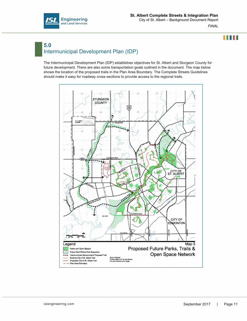
St. Albert Complete Streets & Integration Plan City of St. Albert – Background Document Report
FINAL
islengineering.com September 2017 | Page 11
5.0 Intermunicipal Development Plan (IDP)
The Intermunicipal Development Plan (IDP) establishes objectives for St. Albert and Sturgeon County for future development. There are also some transportation goals outlined in the document. The map below shows the location of the proposed trails in the Plan Area Boundary. The Complete Streets Guidelines should make it easy for roadway cross-sections to provide access to the regional trails.

St. Albert Complete Streets & Integration Plan City of St. Albert – Background Document Report
FINAL
Page 12 | September 2017
6.0 Downtown Area Redevelopment Plan (DARP)
Within the DARP the street network is discussed in detail and broken down into street categories that differ from a traditional classification of roads. The following street classifications are shared: Through-Movement Streets: Streets that are critical through-routes within downtown St. Albert, expected to facilitate high volumes of vehicular and transit movement. They will feature wider roadways, but still accommodate transit and pedestrians.
Balanced Streets: Streets that are highly versatile and will accommodate a wide variety of users including pedestrians, cyclists, transit and private vehicles.

St. Albert Complete Streets & Integration Plan City of St. Albert – Background Document Report
FINAL
islengineering.com September 2017 | Page 13
Pedestrian-Oriented Streets: Streets that will have generous pedestrian realms with extensive amenity and narrow roadways that accommodate modest amounts of vehicular traffic at slow speeds.
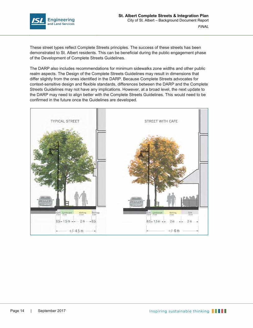
St. Albert Complete Streets & Integration Plan City of St. Albert – Background Document Report
FINAL
Page 14 | September 2017
These street types reflect Complete Streets principles. The success of these streets has been demonstrated to St. Albert residents. This can be beneficial during the public engagement phase of the Development of Complete Streets Guidelines. The DARP also includes recommendations for minimum sidewalks zone widths and other public realm aspects. The Design of the Complete Streets Guidelines may result in dimensions that differ slightly from the ones identified in the DARP. Because Complete Streets advocates for context-sensitive design and flexible standards, differences between the DARP and the Complete Streets Guidelines may not have any implications. However, at a broad level, the next update to the DARP may need to align better with the Complete Streets Guidelines. This would need to be confirmed in the future once the Guidelines are developed.

St. Albert Complete Streets & Integration Plan City of St. Albert – Background Document Report
FINAL
islengineering.com September 2017 | Page 15
7.0 Municipal Bylaws
7.1 Land Use Bylaw
Schedule A of the Land Use Bylaw includes the land use maps that dictate the available right-of-way available for roadways within St. Albert. As new cross-sections and design principles are developed, this map will require updates. Schedule B includes a list of Major Arterial Roadways within St. Albert; this list may see changes depending on the development of the Guidelines. 7.2 Traffic System Bylaw
The review of the traffic system bylaw revealed that cycling is allowed on St. Albert’s sidewalks. This is important to consider in trying to understand cycling culture in St. Albert. Sidewalks that are 1.5 m wide are very narrow for pedestrian-cyclist interactions and sharing the space is more comfortable on a trail that is at least 3.0 m wide. Opinions on interactions between pedestrians and cyclists can be gathered through the stakeholder and public engagement to establish a direction on the preferred facility types to include in Complete Streets cross-sections. 7.3 Residential Solid Waste Bylaw
The bylaw allows waste collection to be at the rear of any dwelling if a lane exists. Where no lanes exist, the collection is to be at the front of the dwelling. The lane and street cross-sections need to consider turning radii for waste collection trucks as well as operating zones for automated collection.

St. Albert Complete Streets & Integration Plan City of St. Albert – Background Document Report
FINAL
Page 16 | September 2017
8.0 Additional Supportive Master Plans
St. Albert has developed a number of Master Plans for various social and economic aspects of living in the City. These Master Plans were reviewed to take note of aspects of plans in place that will benefit from the development of Complete Streets. 8.1 St. Albert’s Community Vision
A following vision for St. Albert’s built environment is shared in the Community Vision: We are connected to one another by a safe, effective and accessible transportation network
that supports public and active modes of movement. We believe community is about people and we design our neighbourhoods to make it easy for
people to connect to one another through parks, trails, and public transportation and community spaces.
We build innovative, long-lasting infrastructure that is efficient, minimizes the use of our natural resources and creates harmony between the natural and built environment.
We build our city to reflect the natural beauty we cherish, maintaining distinct landscaping and architectural standards that cultivate our city’s identity.
Developing guidelines specifically to improve accommodation for active transportation and public transportation will bring St. Albert closer to realizing the above goals. 8.2 Environmental Master Plan
The environmental master plan identifies managing the air quality, reducing energy consumption, and promoting sustainable housing and transportation choices as goals for the City. These goals resonate with the goals of the municipal development plan to introduce more diverse housing characteristics within the City. Newer roadway cross-sections which promote network connectivity and active transportation choices will help support higher minimum densities of dwelling units per net residential hectare. The Environmental Master Plan’s target goals of 30% medium and/or high density residential units for new neighbourhoods and increasing transit ridership faster than the population growth rate will also be better manageable through design standards which prioritize active transportation modes. 8.3 Long Term Transit Department Plan
The Long Term Department Plan provides a framework for the development of future transit services up to the year 2027. The plan shares information from a survey conducted to gather responses from residents and transit operators. Key points included: Residents identified transit priority measures on St. Albert Trail and increased commuter
frequency as top priorities for service improvements Bus operators identified several local and commuter routes which are challenging to keep on
schedule

St. Albert Complete Streets & Integration Plan City of St. Albert – Background Document Report
FINAL
islengineering.com September 2017 | Page 17
This is useful insight for the development of plans for future roadways in St. Albert. Priority should be placed within major arterial cross-sections to provide some form of rapid transit. As part of the Plan, a SWOT (Strength, Weakness, Opportunities, Threats) analysis was conducted. Weaknesses of the transit system include: Transit is introduced in newly developed areas too late and residents develop auto-oriented
lifestyles that prove difficult to change Opportunities of the transit system are described as: The opening of a new park and ride facility south of the City which will allow current local
routes to be completely redesigned for faster and more direct services Threats/Challenges are described as: Local routes are circuitous and time consuming and do not offer a service that is competitive
with automobiles. Low housing densities mean that routes have to travel longer distances to achieve a sufficient
sized customer pool. Several recommendations are included in response to the weaknesses, opportunities, and threats/challenges. Major recommendations that can be achieved through updated roadway design principles include: 1. Keeping local feeder routes as short and direct as possible.
a. Traditional neighbourhood designs with modified grid patterns can help produce collector roadways that are less circuitous.
2. Commuter routes should be maintained as express or limited stop to minimize travel time. a. Roadway cross-sections that accommodate dedicated rapid transit will help achieve this
3. Improving ease of access to transit. a. Sidewalks, crosswalks, curb ramps, and bus stops all have a major impact on the success
of transit services. Roadway standards that go above and beyond transit users will help make transit a viable mode in St. Albert in the future.
8.4 Economic Development Strategic Framework
One key element of the economic development framework is adopting positions, standards, and regulations to ensure that the community’s values and desires are met. Specific goals that Complete Streets Standards would help accomplish include: Build, support, and advocate for a strong network in support of the movement of people,
goods, services, and information that meets the needs of residents and businesses. Plan proactively and position St. Albert as a city ready for growth by having utility capacity,
available land and targeted zoning for development for both residential and employment purposes.
Enhance the tourism capacity of local attractions, recognizing tourism as an economic driver. Continue to focus on the downtown as a critical business and people district in St. Albert and
support the Downtown Area Redevelopment Plan.

St. Albert Complete Streets & Integration Plan City of St. Albert – Background Document Report
FINAL
Page 18 | September 2017
8.5 Economic Development Master Plan
The economic Master Plan outlines several objectives for the city to sustain itself economically, environmentally, and socially. Among these objectives is maintaining cost effective services that support expansion and attraction of desired business/industry. This includes services such as: Available serviced, zoned land An effective transportation network Cost effective utilities A range of housing options for different levels of incomes Leisure, health care, recreational and other community amenities One specific goal to achieve this objective is to ensure that the internal and external transportation networks support the targeted growth. It is suggested to continue to expand the bicycle and pedestrian network in St. Albert in order to support active commutes from residential areas into business areas. Improving the active transportation networks would be especially useful for attracting a wider range of housing choices and allowing St. Albert residents to choose their preferred mode of transportation rather than it being private vehicle by default. 8.6 Cultural Master Plan
The Cultural Master Plan outlines several outcomes for St. Albert: Leverage St. Albert’s network of attractions and venues Nurture St. Albert’s future cultural leaders, artists, volunteers, and audiences Support culture as an engine for a creative economy, attracting and retaining young
professionals Position culture as an integral part of St. Albert’s overall municipal responsibilities A network of Complete Streets can help accomplish these goals by providing attractive linkages to St. Albert’s cultural amenities. The Plan defines St. Albert’s future cultural needs and opportunities. As St. Albert’s population grows, an increase in cultural facilities will be needed. As is observed for national trends, volunteering within St. Albert has also been waning. Encouraging more active transportation can lead to more interactions among people as they commute to and from meeting places such as Downtown. Focusing on culture within St. Albert has broader city-wide implications as well as it can support the re-development of downtown, add economic benefits from cultural tourism, and attract new residents/businesses to St. Albert. Developing Complete Streets Guidelines benefits all three of city-wide implications. 8.7 Social Master Plan
An important aspect of the Social Master Plan is ensuring accessibility is ensured within the City, including to those who are mobility challenged. Three goals identified in the Plan are: An effective transportation system supports residents in accessing employment, education,
health, and community services Available services must meet the needs of those with disabilities at a comparable level to
those without Service limitations exist outside of peak hours

St. Albert Complete Streets & Integration Plan City of St. Albert – Background Document Report
FINAL
islengineering.com September 2017 | Page 19
The Plan also outlines three Actions to achieve these goals: Advocate for public transportation that crosses geographic boundaries Develop a public education and awareness strategy for transportation services Support the implementation of recommendations from HandiBus Review Streets that are designed to match pedestrian needs can help accomplish some of these goals. 8.8 Recreation Master Plan
A few key priorities are mentioned as priorities in the Recreation Master Plan: Priority #1: Ensure community health and well being Priority #2: Bolster Community Development Priority #3: Invest in Recreation Infrastructure Focusing on creating roadway cross-sections that take care of all users helps to achieve all three of these goals. 8.9 Tourism Master Plan
One objective of the Tourism Master Plan is to develop new tourist attractions and events, and enhance existing ones. Tourist attractions are best placed in walkable areas that can support heavy pedestrian volumes. Building new areas of St. Albert with enhanced roadway cross-sections that can support active transportation well will be crucial for achieving goals within the Tourism Master Plan. 8.10 Utilities Master Plan
The utility master plan identifies several Low Impact Development (LID) features as part of the future system demand and infrastructure requirements as shown in the table below. These features can be vetted through the Utilities Department and included in the Complete Streets Guidelines.

St. Albert Complete Streets & Integration Plan City of St. Albert – Background Document Report
FINAL
Page 20 | September 2017
8.11 Smart City Master Plan
Mobility is a key focus of St. Albert’s Smart City Master Plan. The plan imagines a future for St. Albert in which the City is known for it its efficient transportation system and openness to new modes and technologies. The City would also provide instant transit, cycling, traffic condition, and parking supply information to residents to be able to make quick and informed decisions about transportation choices. A built environment that can safely and comfortably support all of the above modes will help support the vision for a smart city and will in turn also add to the success of Complete Streets.

Appendix B Best Practice Report


St. Albert Complete Streets & Integration Plan Best Practice Review
City of St. Albert – Report
FINAL
i s leng ineer i ng.com September 2017
Table of Contents 1.0 Introduction ............................................................................................................ 1
2.0 Philosophy ............................................................................................................. 1
3.0 Overview of Complete Streets in Canada ............................................................... 2 3.1 Calgary Complete Streets Guidelines 2 3.2 Edmonton Complete Streets Guidelines 3 3.3 Toronto Complete Streets Guidelines 3 3.4 Comparison 4 3.5 Additional Canadian Resources 6
4.0 Additional Considerations for Complete Streets ..................................................... 9 4.1 Ride-sharing 9 4.2 Autonomous Vehicles 9
5.0 Conclusions ......................................................................................................... 10
6.0 Summary .............................................................................................................. 10
7.0 Additional Resources ........................................................................................... 11 APPENDICES Appendix A Airdrie Complete Streets Toolbox FIGURES Figure 3.1: Street Classification Summary .................................................................................................. 6


St. Albert Complete Streets & Integration Plan Best Practice Review
City of St. Albert – Report
FINAL
islengineering.com September 2017 | Page 1
1.0 Introduction
To begin the process of developing St. Albert’s Complete Streets Guidelines, ISL completed a review of the Complete Streets work that has been developed to date in Canada. The purpose of providing this review is to familiarize members of the Steering Committee on the intent and objectives of the Complete Streets philosophy. The review will offer a point from which to begin thinking about what to desire from St. Albert’s Complete Streets Guidelines. For further research into specific content, a list of cities with Complete Streets Guidelines is shared at the end of the section as well as a few online resources. 2.0 Philosophy
Complete Streets is a change in roadway design philosophy to provide context-sensitive design that balances the needs of all roadway users. Traditional urban roadway design focused on rigid standards for the streets within a City and were often be auto-oriented in its nature. This meant that pedestrians and cyclists were unintentionally accommodated with often residual infrastructure that may not be as safe or comfortable to use as is desired. The goals of applying new principles to roadway design are to create roadway cross-sections that can accommodate a wider range of transportation modes and consider the land use context of the surrounding area. The cross-sections applied can be flexible and cater to the local character needs of each area within the City.

St. Albert Complete Streets & Integration Plan Best Practice Review
City of St. Albert – Report
FINAL
Page 2 | September 2017
3.0 Overview of Complete Streets in Canada
Only in the last decade have holistic road design principles been branded as Complete Streets. In some areas of North America, they are referred to as context-sensitive design, while in others the work is grouped in planning for active transportation modes. Currently, three cities in Canada, Calgary, Edmonton, and Toronto, have developed Complete Streets Guidelines. The three Complete Streets Guidelines are discussed in more detail in the following sections. However, examples of holistic transportation design principles exist in many other forms in municipalities across Canada, including: The Region of Waterloo: Context-sensitive Regional Transportation Corridor Design
Guidelines (2013) which include guidance on roadway classification, design elements, as well as example cross-sections
The Region of Ottawa-Carleton: Regional Road Corridor Design Guidelines (2000) which include guidance on design elements, as well as example cross-sections
The City of Airdrie: Complete Streets Toolbox (2014) as part of their Transportation Master Plan which highlights design elements which can be used within roadway cross-sections to balance the needs of a wider range of users
The City of Red Deer: Mobility Playbook (2013) which outlines Complete Streets principles for planning and design of more people-friendly places
A list of further resources, as well as American cities with Complete Streets Guidelines is included in Section 7.0. 3.1 Calgary Complete Streets Guidelines
The City of Calgary began to develop Complete Streets Guidelines in order to create more safe, convenient, and attractive transportation modes to residents. The concept of the Guidelines developed from the submission of the 2009 Calgary Transportation Plan which included an extensive section on building complete streets in Calgary. Reviewing Calgary’s Complete Streets Guidelines are important because of the regional proximity to St. Albert. Additionally, the Calgary metropolitan region, and the Capital Region have traditionally had similar growth and design of neighbourhoods in the past 20-40 years. Calgary chose to develop a new roadway classification system for their roads because defining the roads as “local, collector, and arterial” was too prescriptive and not flexible enough to serve many different environments. The process resulted in Calgary creating roadway cross-sections that allowed for increased flexibility in roadway designs. The first section of Calgary’s Complete Streets Guidelines outlines the process of developing a new street classification system for Calgary’s streets. The Guidelines only include the names and descriptions of each of the new classifications; the cross-sections of the new classifications are included in the 2014 Design Guidelines For Subdivision Servicing. Along with the cross-section drawing, a one page document for conditions for which the cross-section should be chosen is also included. This document is included in the list of additional documents for review.

St. Albert Complete Streets & Integration Plan Best Practice Review
City of St. Albert – Report
FINAL
islengineering.com September 2017 | Page 3
St. Albert has expressed a desire in developing new context-sensitive roadway cross-sections for future communities that will be developed. Striking a balance between allowing flexibility and being prescriptive in the minimum standards will be a challenge, but with the right amount of engagement with the development industry and internal administration, it could be a very effective way of introducing more holistic roadway design processes in St. Albert. 3.2 Edmonton Complete Streets Guidelines
Edmonton’s City Council passed the Complete Streets Policy (C573) and the Complete Streets Guidelines in May 2013. The Bylaw states that the City of Edmonton will implement Complete Streets Principles by enacting bylaws, procedures, directives, processes, programs, guidelines, and standards. Edmonton is the closest municipality to St. Albert and the two share many of the same transportation trends and choices. The Edmonton Region Urban Development Institute (UDI) has already been engaged as a stakeholder for the development of Edmonton’s Complete Streets Guidelines. This is beneficial for St. Albert as UDI is aware of the growing influence of Complete Streets principles in urban roadway design. Edmonton’s Guidelines tackle new roadway cross-sections in a different manner than Calgary. Rather than developing new roadway classifications and associated cross-sections, Edmonton leaves the development of cross-sections up to roadway designers. The elements of a cross-section are to be constructed from three dimensions: the relationship of buildings to the street, the land use context of the roadway, and the functional classification of the roadway. The three-dimensional aspects of cross-sections afford roadway designers the flexibility to include the most important elements for a specific context. As part of the implementation of the Complete Streets Guidelines, the City collaborated with utility providers and the industry to develop 21 example cross-sections from different combinations of the three dimensions. In 2015, the example cross-sections were included as an appendix inside the City’s Design and Construction Standards. The example cross-sections act as a supplement to the existing cross-sections in the Design and Construction Standards. Should roadway designers want to use a design which differs from the Complete Streets example cross-sections, the Guidelines are an approved resource which include additional elements and allow for flexibility. 3.3 Toronto Complete Streets Guidelines
Toronto’s City Council directed the City Administration to develop Complete Streets Guidelines in 2014. The final Complete Streets Guidelines were completed and approved in 2017. Toronto’s Guidelines are a comprehensive list of design principles and objectives that generally cover the same design elements, but in a less prescriptive manner than Edmonton’s Guidelines. Because Toronto is a built-out city, the Complete Streets Guidelines are intended for existing streets in Toronto which will be redeveloped or require upgrades. Having guidelines which are more flexible helps with this goal. Toronto’s Guidelines use the role of three different overlays for a single street type: a place-making overlay, a movement overlay, and additional contexts. This process is similar to Edmonton’s in that it leaves the construction of the design up to the road designer. Section 2.3 of the Guidelines includes a list of 16 example street types developed from the design parameters. Each of the street types includes a description of the role of the street, some design objectives,

St. Albert Complete Streets & Integration Plan Best Practice Review
City of St. Albert – Report
FINAL
Page 4 | September 2017
and a rendering of what it may look like. It is emphasized that the rendering is what the street can look like, but that it is not what the street must look like. St. Albert has a major opportunity to create new roadway cross-sections for future green-field development, therefore an approach that is more prescriptive may be more helpful for the City. 3.4 Comparison
As part of the Best Practice Review, the common design elements to be expected inside Complete Streets Guidelines were compared amongst the three Canadian Guidelines. This comparison is not intended to rank the three Guidelines against each other, but rather to start a process to think about which elements may be desired in St. Albert’s guidelines.
Edmonton Calgary Toronto
Principles and Goals
Vision Intent Principles Applicability
Purpose Vision Goals Applicability
Network Design - Network Design
Guidelines Connectivity Indices
-
General Road Design
Travel Lane Width Design Speed Utilities
Travel Lane Widths Design Speed
Travel Lane Widths Design Speed
Pedestrians
Sidewalk Zones Curb Extensions Pedestrian Crossings Streetscape
Amenities
Sidewalk Zones Curb Extensions Pedestrian Crossings
Sidewalk Zones Pedestrian Crossings Placemaking and
Urban Realm Utilities, Maintenance,
and Operations
Cyclists
Shared Use Roadway
Bike Boulevards Bike Lanes Buffered Bike Lanes Cycle Tracks
Shared Use Roadway
Bike Lanes Buffered Bike Lanes Cycle Tracks Multi-use Pathways
Key Cycling Elements
Transit
Bus Stop Location and
Accessibility Bus Stop Amenities Transit Priority
Measures Integration with
Cycling Facilities
Transit Network Design
Transit Priority Transit Stop Design
Key Transit Elements
Goods Movement Designing for Goods Movement
- -

St. Albert Complete Streets & Integration Plan Best Practice Review
City of St. Albert – Report
FINAL
islengineering.com September 2017 | Page 5
Edmonton Calgary Toronto
Intersections
Bikeways at Intersections
Example Intersection Illustrations
Intersection Corners Roundabouts
Accessibility and Universal Design
Intersection Corners Cyclists at
Intersections Transit at Intersections Intersection Signals
and Controls
Green Infrastructure -
Green Infrastructure and LID
Key Green Infrastructure Elements
Traffic Calming Examples of Traffic Calming
Examples of Traffic Calming
Examples of Traffic Calming
Road Classification
Identifying Street Type
New Classification System
New Street Types
Use of Overlays New Street Types
Implementation
Priority Network Maps
Example Cross-sections
Bylaws/Policy Amendments
Education and Outreach
Update Design Standards
Standards Bylaws and Policy Monitoring Processes Education -
Another key aspect to consider is how much detail to cover for each of the design elements. Typically, design elements inside Complete Streets Guidelines are discussed from two perspectives: Principles: What is the reason behind using the element, and what objectives does it serve? Details: What are specific minimums and maximum dimensions for a specific design element? Edmonton’s guidelines share design dimensions for features such as sidewalk zones, and cycling facilities, whereas the Calgary and Toronto Guidelines focus more heavily on design principles and objectives. A decision on the type of information shared on design elements will depend on what other resources the City has on-hand for roadway designers to use. For example, the 2017 TAC Geometric Design Guide for Canadian Roads includes extensive design dimension details for bicycle and pedestrian design.

St. Albert Complete Streets & Integration Plan Best Practice Review
City of St. Albert – Report
FINAL
Page 6 | September 2017
3.5 Additional Canadian Resources
3.5.1 Airdrie
Functional Classification
Airdrie’s Complete Streets Toolbox takes a more prescriptive approach with roadway cross-sections and functional classification. However, the cross-sections developed offer more flexibility than traditional roadway cross-sections. The roadway hierarchy is broken into three categories which contain further street types based on land use and mobility requirements: Skeletal Arterial: Streets which place a high degree of importance on the mobility function of streets. Multi-Modal Liveable Arterial: Streets which provide higher capacity within communities but they are characterized by the function they serve, not the size of the street. These streets connect neighbourhoods. Local: These streets do not serve a city-wide role and they can serve a variety of land uses. Figure 3.1 below displays a chart which shows what time of land-use each new street classification can comply with.
Figure 3.1: Street Classification Summary

St. Albert Complete Streets & Integration Plan Best Practice Review
City of St. Albert – Report
FINAL
islengineering.com September 2017 | Page 7
Each roadway cross-section page shows a cross-section with a typical width; some cross-sections also show alternative cross-sections with certain design features swapped out for other uses. Each page also includes information on design treatments for each mode of transportation. These treatments are categorized as “required”, “high priority”, or “low priority”. For example, under design treatments for pedestrians on a skeletal arterial roadway, a buffer between the pedestrian space and the vehicle space is a required design treatment. In total, Airdrie’s Complete Streets Toolbox offers 15 different cross-sections available for use. Design Elements
The Toolbox includes pages for individual design elements for pedestrian, cycling, transit, traffic calming, and goods movement. Some of the elements do include design dimensions, however, most of the design elements discuss principles of using the element, including context and objectives. References are provided to the TAC Geometric Design Guide for Canadian Roads. 3.5.2 Waterloo
Functional Classification
The Region of Waterloo also used a prescriptive approach to their roadway cross-sections. An additional challenge for the Region of Waterloo was including cross-sections for rural and urban roadways into one functional classification. An emphasis was placed for maintaining a traditional functional classification hierarchy. Benefits of maintaining a traditional classification were listed as: Co-ordinating land use and transportation Establishing appropriate roadway right-of-way Establishing roadway and boulevard design standards Establishing traffic operations guidelines Establishing maintenance operations practices The guidelines share three new rural cross-sections and five new urban cross-sections with some alternative sections. A map of the region is included showing the designations of the existing roads according to the new roadway classifications. Each of the cross-sections include broad considerations for different modes, adjacent land use and access, building scale and orientation, ROW width, speed limit, connectivity, crosswalks, parking, and intersection spacing. A cross-section and plan is shown in the guidelines for each street type developed, including the individual design elements used and their dimensions. A list of optional design treatments and their associated design widths is also included. Design Elements
Design Elements in Waterloo’s Guidelines are broken down into three categories; boulevard guidelines, roadway guidelines, and general guidelines. Boulevard guidelines mostly include information on elements such as landscaping, lighting, and site furnishings. Roadway guidelines include information for different types of lanes that can be within the curb-to-curb width. Finally, general guidelines include other topics such as utilities, maintenance, intersections, transition areas, and design speeds. Most elements include design principles, including the context and objectives, as well as the other design considerations. Some of the roadway guidelines include

St. Albert Complete Streets & Integration Plan Best Practice Review
City of St. Albert – Report
FINAL
Page 8 | September 2017
recommendations for lane widths, however, most design elements do not include specific design dimensions. 3.5.3 Accessible Street Design (Vancouver)
Vancouver’s accessible street design guidelines include principles for universal design which enable a built environment usable by all people. The document describes definitions for people that the Guidelines are trying to improve design for. The main focus of the Guidelines is establishing the needs of mobility impaired visually impaired individuals. These needs are based on physical capabilities of individuals. The next section of the Guidelines focus on design elements and which parameters of each design elements need to be considered to meet the needs of individuals with mobility or visual impairments. Design elements include pedestrian infrastructure, street furniture, landscaping, parking, bus stops, lighting, and wayfinding.

St. Albert Complete Streets & Integration Plan Best Practice Review
City of St. Albert – Report
FINAL
islengineering.com September 2017 | Page 9
4.0 Additional Considerations for Complete Streets
4.1 Ride-sharing
Ride-sharing has grown considerably over the last few years as a result of Transportation Network Companies (TNCs, more commonly called Private Transportation Companies (PTCs) in Canada) using cellphone applications to connect passengers to the closest contracted vehicle available for hire. St. Albert council has recently approved an amendment to the Business License Bylaw to regulate companies operating vehicles for hire, including Transportation Network Companies. St. Albert has a high percentage of vehicle ownership and the percentage of people relying on ride-sharing companies or even taxis in the city would not be at levels where space out of the roadway network should be dedicated to the pick-up or drop-off of passengers. Pick-up and drop-off at major destinations such as recreation centers or big-box commercial developments is done within parking lots, usually directly in front of the front doors. In more walkable areas such as downtown areas, parking lanes are commonly used as pick-up and drop-off locations. As part of the reallocation of space for the downtown bike lane project in the City of Edmonton, a small portion of a parking zone on one street is restricted to 5-minute parking and only for the use of passenger loading. 4.2 Autonomous Vehicles
Although research and experimentation of fully automated driving is constantly developing, autonomous vehicles are still many years from being implemented. At this time, considerations for autonomous vehicles are not required as part of St. Albert’s Complete Streets Guidelines. With full automation, broad level impacts to transportation roadway design could include decreased lane widths and reduced demand for paid-parking. The Guidelines will be a living document and can be updated regularly with changing transportation practices and trends.

St. Albert Complete Streets & Integration Plan Best Practice Review
City of St. Albert – Report
FINAL
Page 10 | September 2017
5.0 Conclusions
Based on the review, ISL will discuss the following three topics with the Steering Committee about developing the Complete Streets Guidelines: 1. For new cross-sections, whether to use a more prescriptive approach or a flexible one? 2. What design elements to include in the Complete Streets Guidelines? 3. Between design principles and design details, where should the focus of individual design
elements be? 6.0 Summary
As part of the review of Complete Streets Guidelines in Canada, ISL reviewed documents from the following municipalities: City of Calgary City of Edmonton City of Toronto City of Airdrie Regional Municipality of Waterloo All of the guidelines typically included similar information with respect to design elements, although differences were noted in the extent of the details, and how the municipalities treated these design elements. However, as a minimum, design elements for the pedestrian realm, cycling, transit, and traffic calming covered were included within all of the guidelines. As detailed in Section 3.0, the approach for producing new cross-sections also varied for each municipality. Each of these guidelines were produced to be used by a wide variety of users, such as residents who use the streets, designers who design the streets, and people involved in building the streets and operating businesses along the streets. The goal of providing users of St. Albert’s guidelines with the ability to envision an organized hierarchy of streets which incorporates Complete Streets principles can be accomplished by developing a wider range of cross-sections similar to the City of Airdrie and the City of Calgary. This methodology was also observed with Waterloo’s guidelines, although the number of cross-sections in Waterloo’s guidelines is not as extensive as Airdrie’s or Calgary’s. Alternatively, if the goal is to give users the tools to develop their own cross-sections, approaches similar to the City of Edmonton and the City of Toronto can be used. Based on our understanding of the goals and objectives that the City of St. Albert has established for its own Complete Streets Guidelines, ISL believes that of the examples of municipal best practice in a Canadian Context that the City of Airdrie’s version of a Complete Streets Guideline is the most appropriate and applicable example for the City of St. Albert to model its Complete Streets Guidelines after.

St. Albert Complete Streets & Integration Plan Best Practice Review
City of St. Albert – Report
FINAL
islengineering.com September 2017 | Page 11
7.0 Additional Resources
A list of Complete Streets related work to date is available at the Complete Streets For Canada webpage. The website includes a map with all the places that have developed Complete Streets Policies, Guidelines, Active transportation Plans, as well as Complete Streets Example projects. There is a similar webpage available for American cities, organized by Smart Growth America. The website addresses are shared below: www.completestreetsforcanada.ca www.smartgrowthamerica.org For further reference, below is a list of a few American cities with Complete Streets Guidelines. ISL has included PDF versions of the Guidelines. New York City: Street Design Manual (2015) Boston: Complete Streets Design Guidelines (2013) Chicago: Complete Streets Chicago: Design Guidelines (2013) Philadelphia: Complete Streets Design Handbook (2013) San Francisco: Better Streets Plan (2010)


Appendix C Stakeholder Engagement Reports


Complete Streets Design Guidelines and Implementation Strategy
Stakeholder Workshop Summary
Project Overview
The City of St. Albert has retained ISL Engineering and Land Services to develop and advise on the St. Albert Complete Streets Design Guidelines and Implementation Strategy. ISL has brought in Nelson\Nygaard, internationally acclaimed Complete Streets experts, to assist with the technical work.
Complete Streets is a change in roadway design philosophy to provide a design that balances the needs of all roadway users. Under this philosophy, streets interface with buildings, businesses, open spaces, and parks to provide an urban environment that is much more than a corridor for vehicles. The integral components within a cross-section, such as driving lanes, cycle paths, sidewalks/trails, and boulevards, are scaled to match local priorities. This approach to land use planning and transportation design promotes alternative modes of travel, such as transit, walking, and cycling.
The complete streets philosophy acknowledges that not all components may be present within a corridor in all locations across the city, and trade-offs may be required. The design principles will be applied to retrofit existing roadways and will also be used for the design of future roadways.
What We Asked
On Monday, September 25, 2017, participants were asked to join us to discuss the Complete Streets initiative for the City of St. Albert and provide their feedback on the project and the integration plan. There were two workshop sessions held. The internal stakeholders met in the morning, and the external stakeholders’ met in the afternoon. This gave each stakeholder group an opportunity to identify opportunities for consideration in developing the final design.
There was a total of 18 participants in attendance at the Internal Stakeholder morning workshop representing the following City of St. Albert departments:
• Environment
• Corporate Communications
• Recreation and Parks
• Community and Social Development
• Economic Development
• Planning
• Engineering
• Utilities
• As well as the RCMP
There was a total of 17 participants in the External Stakeholder afternoon workshop representing the following organizations:
• UDI /Strata
• Melcor
• Landrex
• Genstar
• Averton Homes
• Select Engineering
• St. Albert Public Schools
• Great St. Albert Catholic Schools

• St. Albert Bike Association
• Canada Post Corporation
• ATCO gas
• Telus
• Shaw
What We Heard
Throughout the day, the City of St. Albert’s Project Manager and the ISL Engineering and Nelson\Nygaard consultants were available for one-on-one conversations with the participants.
Q&A Session
There was a presentation from ISL Engineering and Nelson\Nygaard followed by a structured Q&A where participants were asked to comment about transportation within St. Albert today, ideal transportation in other cities, and what the ideal transportation would look like in the future for the City.
Table 1 on the following page outlines the responses we got from both workshop sessions.
Dotmocracy Board
The Dotmocracy Board was placed at the back of the room and participants from the Internal Stakeholder morning workshop were given six “Happy Face” stickers and were asked to place one sticker per row to choose between which trade-offs they would prefer in terms of transportation importance. The afternoon External Stakeholder session participants were given six “Star” stickers to differentiate from the morning session and were asked to do the same activity.
The results from this exercise are included in Table 2.

Table 1: Comments from Structured Q&A Session
Morning Session Afternoon Session How do you primarily get around? • Drive to work,
• Multi-modal trip
• Bike for errands
• Weather impacts affect how people get around
• Transit – used when cost effective and convenient (for concerts and events)
• Cycle
• Transit
• Walk
If you had a choice, how would you get around?
• Transit
• Walking
• Proximity of destinations determines mode of transportation
• Perceptions or what is safe, convenient, or timely influence choice
• Connectivity or sidewalks, bicycle infrastructure, and transit influence choices
• Multiple factors to consider
• Walk
• Cycle
• Drive
What do St. Albert Streets do well? • Safety for driving and walking
• Snow Clearing (sometimes onto sidewalks)
• Trails
• Landscaping/tree lined streets
• Streetscape
What do they not do well? • St. Albert Trail signal lights timing
• Pedestrian paths
• Pedestrian and transit opportunities
• Pedestrian safety
• Snow on sidewalks – impacts pedestrians
• Education and lack of responsibility
• Need better illumination
• Driveways cross and separate sidewalks
• Pedestrian visibility
• Carriageways too wide
Beyond just moving people, what purposes do city streets serve?
• Gathering places
• Streetscaping
• Play space (where appropriate) such as street hockey in residential areas
• Parking
• Utilities
• Doors
• Open space
• Streetscape
• Place for people to gather, play, enjoy
• Drainage
• Utilities

Morning Session Afternoon Session Have you visited a place with really great streets? If yes, where was that, and what did you like about them?
• Canmore, Alberta
• Main Street – Wetaskiwin, Alberta
• Stephen’s Avenue – Calgary, Alberta
• Niagara on the Lake
• 50th Street, Leduc,
• George Street, St Johns
• Perron Street, St Albert What they all have in common: Green space, great connections, sidewalk cafés, attractive, restrictions on vehicles, pedestrian-only streets, multi-modal on busy roads, walkable, and safe
• Málaga, Spain
• Stapleton, Denver What they all have in common: Really wide sidewalks, open space, large lot sizes
If you were designing St. Albert streets from scratch, what would be different about it?
• Prioritize transit
• Create pedestrian-only streets
• Transit downtown centre
• Symmetrical, narrow carriageway
• Lower design speeds
Miscellaneous comments • Perception of “snow” impacts
• Lanes disappear under snow/ice
• More options are good
• Age affects relationship with signage
• Testing/inconsistency lead to concerns
• Lacking “purposeful” walking paths
• Utilities considered too
• Transit access including bus stops
• Looking at back lanes
• Need to consider regional perspective of some roads
• City should focus on new development
• City should consider speed reduction, allowing for sharper horizontal curves
• City should consider tightening the corner radii at intersections
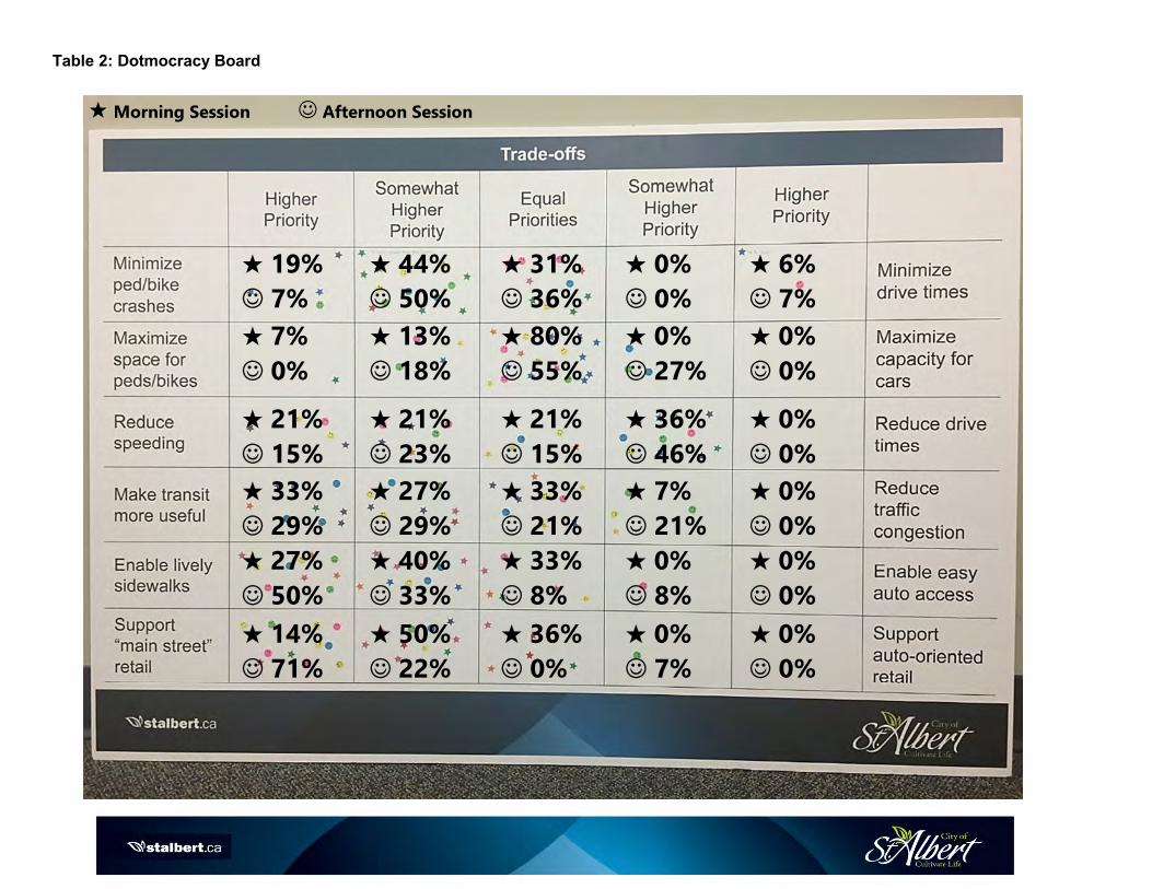
Table 2: Dotmocracy Board
★ 19%
☺ 7%
★ 44%
☺ 50%
★ 31%
☺ 36%
★ 0%
☺ 0%
★ 6%
☺ 7%
★ 7%
☺ 0%
★ 13%
☺ 18%
★ 80%
☺ 55%
★ 0%
☺ 27%
★ 0%
☺ 0%
★ 21%
☺ 15%
★ 21%
☺ 23%
★ 21%
☺ 15%
★ 36%
☺ 46%
★ 0%
☺ 0%
★ 33%
☺ 29%
★ 27%
☺ 29%
★ 33%
☺ 21%
★ 7%
☺ 21%
★ 0%
☺ 0%
★ 27%
☺ 50%
★ 40%
☺ 33%
★ 33%
☺ 8%
★ 0%
☺ 8%
★ 0%
☺ 0%
★ 14%
☺ 71%
★ 50%
☺ 22%
★ 36%
☺ 0%
★ 0%
☺ 7%
★ 0%
☺ 0%
★ Morning Session ☺ Afternoon Session

There were two interactive workshop activities planned for both the morning and afternoon sessions: the Challenges & Outcomes Activity and the Mock Street Exercise.
The morning workshop had robust conversation and feedback during the Q&A portion, resulting in a time constraint. We offered the participants the choice between the two activities, in which the Mock Street Exercise was chosen. The afternoon workshop session was able to complete both activities.
Outcomes & Challenges Activity
The first activity (for the External Stakeholder afternoon session) was a collaborative exercise in which we asked participants to brainstorm the desired Outcomes and Challenges of the Complete Streets project. Participants were split into groups of about 5, and each group had a Table Facilitator either from ISL Engineering or Nelson\Nygaard to help organize the activity.
The table Facilitator asked each of the participants what they felt the desired outcomes were for the Complete Streets project. Each Outcome given was written down on an individual card and then the cards were distributed to everyone around the room so that everyone had a different card from a different table. Participants took their cards that were given to them, and were instructed to place them up on the wall and the rest of the cards were grouped into “like” themes that fit their card best until there were no cards left. We were left with six themes for the participants to choose from. The activity was repeated for the Challenges portion of the exercise.
This exercise was successful in collaborating with other stakeholders to find out what their concerns about the project were and what they hoped to come out of the project. It was also successful in letting the stakeholders’ converse together to hear about challenges and outcomes that maybe did not occur to them before. Feedback from this exercise is included in Table 3 below.

Table 3: Verbatim Feedback from Desired Outcomes & Challenges Activity
Desired Outcomes Challenges
• Aesthetics
• Character of St. Albert
• Better quality of life for residents
• Land being used more efficiently
• Variety of possible cross-sections
• Land use diversity
• NIMBY-ism
• Residents opposition to change
• Different Ideals
• Cost and space requirements
• Engineering Design leaves little deviation
• Improve St. Albert Trail
• St. Albert Trail function for cars
• Smooth traffic flow
• St. Albert Trail congestion
• Restricted roadway cross-sections
• Engaging community
• Pedestrian lanes
• Sidewalks that make it to their destination
• Need better access for pedestrians
• Separated cycling facilities
• Create more opportunities for fitness
• Need protected bike lanes
• Design roads for increased traffic flow
• Rework City’s Park Space requirements
• Public Works – resists change and has ability to overrule the City
• Council Direction – administration’s ability to be progress is low
• Increased safety for the City
• Play streets
• Homes that back onto trails
• Safe and comfortable street crossing
• Community-zoning restrictions
• Balancing safety versus functionality and mobility
Mock Street Exercise
For the second workshop activity, participants were put into groups of about 6, and were asked to re-design roads in St. Albert (given the choices of St. Albert Trail, Dawson Road, or Perron Street) using a large map representing the road, and foam boards representing roads of various widths, bus lanes, parks, bike lanes, and new ideas (boards were made to scale). Their task was to re-design the road with their desired amenities, such as green space and bike lanes, while still being a functional and safe road for others to use.
This exercise was successful as it allowed groups to discuss what is important to them as a City stakeholder. Participants were able to work together to design a road that they could all see themselves driving on every day. There were great discussions in each group, both the morning and afternoon sessions. It was interesting to see what each group came up with.
Photographs of the mock streets from both workshop sessions are provided below.

Morning Workshop Mock Streets
Dawson Road: The table participants developed a 3-lane cross-section that allowed for a travel lane in each direction, with left-turn bays accommodated at intersections. Where possible, the table participants felt that the centre lane could have low maintenance landscaping in between the left-turn bays. The leftover space between the existing curbs could be used for a designated on-street bike lane. Beyond the curbs, the corridor would be landscaped on both sides of the roadway, with a sidewalk on the side with the bike lane, and a multi-use trail on the other.

Perron Street: The table participants developed five different scenarios, with each option giving a greater priority to a different mode of travel or street element. No consensus was reached about which option was the best; however, there does seem to be a common element of public realm space in all of the scenarios.

Afternoon Workshop Mock Streets
Dawson Road: The group discussed the need for four travel lanes for the roadway. Due to the relatively low volumes, it was decided that the roadway could potentially operate with two travel lanes with a left-turn lane in between. Participants brought up that Dawson road has no major destinations at either end of it, and therefore, is not the best example for an arterial road within the City. Rather it provides access to two arterials roadways. The group decided to add a multi-use trail on both sides of the road, separated by a landscaped boulevard. The discussion around bike facilities revolved around the safety of vulnerable users within the carriageway and the lack of employment destinations within St. Albert. Participants felt that they would not feel safe allowing children to cycle on bike lanes in the carriageway even if they were separated with a buffer or a concrete median. The group also felt that cycling could be accommodated adequately away from the carriageway, with the use of multi-use trails. The group cited a lack of commuters travelling to employment within St. Albert as the reason for choosing multi-use trails over on-road cycling facilities. The group raised concerns over the 37.0 m right-of-way (ROW) standard for undivided arterial roads. Through the activity, it was demonstrated that 26.0 m was sufficient for the operations of an arterial roadway, and anything more was an inefficient use of space. The group decided that the cross-section shown in the picture could be used as a future cross-section for any arterial road within the City.

St. Albert Trail (short-term): There were comments from the participants saying that the road that their group was assigned ended up looking very similar to what the current road looks like now. The table participants felt that a centre median was important to divide the direction of travel, and allow for left-turn bays at the intersection. Consensus was that three travel lanes was a good number, but they felt that the inside lane should be designated as a HOV lane in the peak hours to encourage and give priority to transit and ride-share options. The table participants felt that beyond the physical roadway, landscaping needed to be improved, and that a sidewalk / multi-use trail combination would be beneficial. There was discussion about the need for public realm space; however, the table participants felt that the existing land use did not support it.

St. Albert Trail (long-term, with LRT): The table participants discussed many options for the conversation of St. Albert Trail from the road that it is today to a Complete Street that incorporates the LRT. As a starting point, the table laid out a sample of the car centric road for comparison purposes. This is reflected by the 6-lane roadway with the centre left-turn lanes at the top of the image. The group then explored two options for including a wide LRT ROW on both the east side and in the middle of the ROW. Various configurations of pedestrian, cyclist and green infrastructure were then added to the LRT Corridor to build out the active modes contribution to the Complete Street. In the bottom image the combined pedestrian/cyclist pathway was added to the west side of the ROW and separated from the vehicle travel lanes through a treed boulevard. On the east side, a sidewalk and bikeway were added east of the LRT to place the active infrastructure adjacent to properties to provide person access. Six travel lanes and a median left-turn lane were provided. With the centre running LRT the group favoured wider sidewalks and additional space for people along the corridor and chose to reduce the number of travel lanes along the trail from six to four in favour of the more robust pedestrian and cyclist space. The group discussed the overall width of the LRT ROW being 13 m and questioned if all of that width was necessary at all points long the ROW. This may reflect the provision of placing left-turn lanes closer to the train and providing for a consisted space allocation along the corridor to avoid the in/out chicane effect of narrowing and widening the ROW at intersections. This is reflected in the middle design that places some of the left-turn lane element within the design space of the LRT.

Feedback Highlights:
• Participants indicated that they would like more pedestrian pathways as well as bike lanes to be more accessible, with better connections throughout the city.
• Participants feel it is important to design pedestrian-friendly spaces within the city. More green space and sidewalk amenities.
• All participants agreed that safety is one of the most important aspects of street design and that sidewalk visibility (i.e., street lighting) could be better in some areas.
• Several participants are concerned about better transit and access to transit in St. Albert (bus stops more accessible in winter months).
• Quality of life for the City of St. Albert is very important. Don’t want to lose the aesthetics and the “small town” feel of the City.
Next Steps
The City of St. Albert, along with their consultants will be hosting a Public Open House on November 15, 2017, to solicit information from the public on the topics discussed at the workshop. Feedback from these events will help the City and their consultants develop the Goals and Objectives for the Complete Streets Project. These in turn will be used to develop a set of Complete Streets Guidelines for the City of St. Albert. Once the guidelines have been established, the City’s design standards will be updated to reflect the Complete Streets Philosophy.
There will be regular communication updates about the project and future community engagement opportunities distributed to interested stakeholders on the contact list, and on the City’s website.

Complete Streets Design Guidelines and Implementation Strategy Public Open House Summary
Project Overview The City of St. Albert has retained ISL Engineering and Land Services to develop and advise on the St. Albert Complete Streets Design Guidelines and Implementation Strategy. Complete Streets is a change in roadway design philosophy to provide design that balances the needs of all roadway users. Under this philosophy, streets interface with buildings, businesses, open spaces, and parks to provide an urban environment that is much more than a corridor for vehicles. The integral components within a cross-section, such as driving lanes, cycle paths, sidewalks/trails, and boulevards, are scaled to match local priorities. This approach to land use planning and transportation design promotes alternative modes of travel, such as transit, walking, and cycling. The complete streets philosophy acknowledges that not all components may be present within a corridor in all locations across the city, and trade-offs may be required. The design principles will be applied to retrofit existing roadways and will also be used for the design of future roadways.
What We Asked On Wednesday, November 15, 2017, attendees were asked to join us to discuss the Complete Streets initiative and explain what complete streets are, while soliciting feedback on the draft goals for the project. The open house was held from 4:00 to 7:30 P.M. at Red Willow Place in downtown St. Albert.
The room was organized with boards around the room and a “tour guide” format was used. Attendees had the option of touring the boards with a facilitator from either the City or ISL to guide them through and answer any questions they had about the project.
There was a total of 31 people in attendance at the public open house. Residents, members from the City of St. Albert, City of Edmonton, and the government of Alberta were among the attendees.
What We Heard Throughout the evening, the City of St. Albert’s Project Manager, Dean Schick, and acting Project Manager, Katie Mahoney, and several of the ISL Engineering consultants, were available for one-on-one conversations with the attendees about the boards or any of the exercises around the room. Copies of the boards from the open house are enclosed in Appendix A.

Dotmocracy Board There were two Dotmocracy Boards among the informational boards around the room: “As Street Design Influences Speeds” board and “Trade Offs” board. Attendees were greeted at the sign-in table and were given a set of stickers that they could use to participate in both Dotmocracy Board exercises.
For the “As Street Design Influences Speeds” board, attendees were able to choose what they believed to be an appropriate speed limit for a roadway, as well as how to achieve that (see Table 1). For the “Trade Offs” board, attendees were asked to place one sticker per row to prioritizing between which trade-offs they would prefer in terms of transportation importance (See Table 2). This exercise allowed the project team to see where the public’s priorities are as well as letting the public physically see where other’s placed their priorities also. Sticky Wall Activity As an added engagement activity, we added the individual survey questions onto the Sticky Wall and attendees were invited to write down their answers onto a card and place it below the question. This allowed for more interactivity within the room.
Feedback we heard from the Sticky Wall Activity:
Question Answers How do you primarily get around? • I would love to only use transit and walk for
transportation just like Tokyo. • Transit/walk • Vehicle, walk, bike (spring, summer, fall)
If you had a choice, how would you get around?
• Depends on needs (i.e., groceries = vehicle, causal recreation = walk or bike)
• Walk What do St. Albert streets do well? • As St. Albert increases density walkways
and green space become more of a need, incorporate trees into design
• In new neighbourhoods there’s still wide boulevard and green trees beside sidewalk
What do St. Albert streets not do well? • Place block signs on St. Albert Trail (visit Division Street in Spokane, Washington to see how it is done)
• No block numbers on the street signs Beyond just moving people, what purposed does a street serve?
• First impression to a city • Provide separation between vehicles and
pedestrians as road speeds increase • Prioritize safety and mode share space
equity • Streets offer more amenities than mobility
(e.g., sense of space rejuvenation)

Question Answers Have you visited a place with really great streets? Where was that, and what did you like about them?
Copenhagen, Denmark Sufficient space for pedestrians, bikes,
and vehicles Supported by robust public transit Mix of business, social, cultural uses
Yueyang, China
Small city in China (~1 million population) Green and walk-friendly Near lakes and many trails to walk near
the lakes Beautiful landscaping
If you were designing St. Albert streets from scratch, what would you do differently?
• Consider how the non-asphalt space is being used
• More efficient use of space Open House Feedback Form Attendees had the opportunity to provide comments and feedback about the overall satisfaction from the event itself (i.e., the time, material covered, the venue, etc.). The results from the feedback forms are enclosed in Appendix B. Online Survey Summary The “St. Albert Complete Streets Questionnaire” was launched on the City’s Complete Streets webpage and open to the public on the November 16, 2017, and has been extended to December 11, 2017. Attendees at the open house were given the opportunity to fill out the surveys on a physical paper copy at the venue or to log in on the Complete Streets website (https://stalbert.ca/cosa/participation/complete-streets) to take the survey. Upon closing the survey, the results taken from SurveyMonkey were gathered and are enclosed in Appendix C. These results also include the hard copy surveys that were collected at the open house (included at the end of Appendix C).

Table 1: Dotmocracy Board 1
29%
57%
14%
10%
33%
57%

Table 2: Dotmocracy Board 2
70%
18%
0%
0%
12%
38%
29%
24%
0%
9%
11%
57%
11%
5%
16%
39%
11%
33%
6%
11%
50%
22%
22%
6%
0%
66%
22%
6%
0%
6%

Mock Street Exercise As another interactive element of the Public Open House, attendees were able to view three major streets in St. Albert (Perron Street, St. Albert Trail, and Dawson Road), and were asked to re-design them using a large map representing the road, and foam boards representing roads of various widths, bus lanes, landscaped boulevards, cycling facilities, and new ideas (foam boards were made to scale). Their task was to re-design the road with their desired amenities, appropriate for the context of the roadway such as green space and bike lanes, while still being a functional and safe road for others to use. This exercise allowed attendees to look at the roadway in a different light. They were asked to re-design the roadway from the perspective of a resident, commuter, and as a pedestrian. Individuals were able to work together or alone to design a road that they could physically see themselves using every day.

Feedback Highlights: • Most attendees use a motorized vehicle to get around. • Attendees would prefer to either walk, bike, or use public transit to get around. • St. Albert has areas where green space and recreational trail connections work very well. • Need more consistency in terms of sidewalks on each street. • Desire for more pedestrian and bike-friendly areas and sidewalks. • Attendees agreed that safety is one of the most important purposes of a city street. • Streets should be clean and well lit with wider sidewalks. Next Steps The consultant will use feedback from this open house to guide the development of St. Albert’s Complete Streets Guidelines document. Once the Guidelines have been completed, the City, along with the consultant, will host a second open house to present them. There will be regular communication updates about the project and future community engagement opportunities distributed to the attendees who provided their emails and contact information at the sign-in table. There will be updates provided on the City’s website as well.

Stakeholder Workshop Summary
What we asked: On March 15, internal and external stakeholders gathered to discuss proposed cross-
sections developed, as part of the Complete Streets Guidelines. The session for the internal stakeholders
took place from 1:00 PM-2:30 PM and the session for the external stakeholder took place from 3:00 PM-
4:30 PM. At both sessions, the project team introduced the proposed cross-sections and explained
reasoning for the choices and trade-offs made for each cross-section. Stakeholders had the opportunity
to ask questions about various aspects of the cross-sections, as well as the background information that
fed into the development of the cross-sections. The session also offered a chance for stakeholders to
bring up concerns regarding infrastructure and dimension choices.
Internal Stakeholder Feedback Summary: The purpose of the typologies, the elements included, and
how local services will operate, were discussed through questions and statements from internal
stakeholders.
Space
Clarity needed for purpose of space in residential cross-section.
It was questioned how more width for pedestrians is an efficient use of space.
Questions around the Crosstown and Connector width of trails and the purpose it serves.
It was asked whether there be possibilities for narrower local residential right-of-way as a result of
residential lanes.
Elements
Proximity of trees to the residential and industrial cross-sections is thought to be close to the road—
possibly impacting traffic flow.
Preference is to have further discussions on elements to be included within each typology.
It was questioned how older developments will incorporate new styles of sidewalks and landscaping
related to the typologies.
Lighting of laneways suggested, to differentiate from traditional lanes.
Noted that parallel parking is not an option on laneways, due to City right-of-way.
Typology
Speed limits were questioned in relation to each street typology.
Statements around the naming of the street typologies arose.
Clarity on how the new typology names overlap traditional names, i.e. connector being comparable to
collector.
Utilities and Services
Questioned how bus stops will be taken into consideration for Crosstown residential.
Noted that garbage collection would not be done via laneways.
Placement of utilities will be discussed further; underneath the roadway is thought to be the current
approach.

External Stakeholder Feedback Summary: The purpose of the typologies, the elements included, and
how local services will operate, along with general comments, were discussed through questions and
statements from external stakeholders.
General
Drafting of guidelines considered a lot of work for something that only might happen in the future.
Space
Questioned why bike lanes are included in some cross-sections and not in others.
Questioned clarity on where bike lanes are allowed to be.
Space efficiency was questioned as front space is 0.9m in neighbourhoods, compared to current 0.5m.
Ponds are thought to be at-risk of forming in laneways along property lines.
Questioned why Crosstown shared-use paths are 4.0m.
Questioned why the sidewalks are 2.4m in neighbourhoods.
Questioned whether guidelines fit into neighbourhoods where sidewalks are currently on only one
side of the street and there are small areas with no houses.
Elements
Questioned whether parking would be included on arterial in commercial areas.
Suggested that conversion chart be developed to assist in transition from old to new typologies, so
industry can adapt.
Lighting on garages and not on light poles suggested as alternative.
Typology
Consideration needs to be made for how the cross-sections would transition between different land
use areas.
Crosstown and Connector Industrial right-of-ways are thought to be redundant.
Does not seem cost-efficient to implement cross-sections, compared to rural cross-sections that other
municipalities implement.
Utilities and Services
Placement of utilities will be discussed further; placing them under the road thought to be an option,
while boulevard is not thought to work.
Additional Feedback: After the internal and external discussion took place, the Edmonton Region
Branch of Urban Development Institute (UDI) sent a comprehensive list of feedback on the cross-
sections. The following is a summary of the comments.
General
Complete Streets is not a one-size-fits-all; adaptability to individual cases is necessary.
Costs in relation to space used will need to be considered carefully.
Use of traditional nomenclature is necessary to industry understanding.

Excessive Width and Space of Lanes and Roads
Shared-use paths for Crosstown Residential (38m and 45m, berm), Crosstown Industrial, Connector
Residential typologies, are considered too wide, related to construction and maintenance.
Right-of-ways for Crosstown Residential (38m and 45m, berm), Crosstown Industrial, Connector
Residential, residential laneway typologies are considered too wide.
Sidewalks for Crosstown Residential (38m and 45m, berm), Crosstown Industrial, Connector
Residential typologies, are considered too wide.
Local Residential and Local Industrial minor sidewalk width increases were questioned.
Cycle Lane for Crosstown Residential (38m) and Connector Commercial are considered excessive at
2.1m.
Boulevards are thought to be too wide in Neighbourhood Commercial and Neighbourhood
Residential.
Approval for the Neighbourhood Residential taking into account a reduced carriage width at 22m.
Width inconsistency between Crosstown Industrial and Crosstown Residential inside lanes was noted.
Questioned why the berm area is so large.
Overall, land protection for future accommodations is thought to be excessive.
Turning Options
Questioned whether a meandering trail or a curbside trail alignment has been considered for
Crosstown Residential (45m, berm), Crosstown Industrial and Connector Commercial.
Questioned the purpose of Right Turn bays encroaching section boulevards for Crosstown Residential
(38m and 45m, berm) and Crosstown Industrial.
Utilities and Services
Stated that the cost for crowned alleys is high due to gutter installation.
Suggested that gutters may need additional drainage infrastructure to be installed.
Suggested that gutters are thought to be shallow and inappropriate for the crowned alleys; possibly
creating run-off onto private property.
The ability to have emergency access along a lane with concrete swale gutters was questioned.
Lighting requirements for commercial/industrial areas was questioned.
The usability of an unlit version of a Residential laneway was questioned.
Room for utilities on boulevards is not thought to be large enough.
Related to a third-party installation, gas easement on property is not well-represented.
Related to a fourth-party installation, easement on property is not well-represented.
Stated that deep utility lines are prone to damage.
Suggested that laneway lighting has potential, however, there is thought to be an inadequate amount
of space for the power trench alignment.
Suggested that there is a need to show deep or shallow pipe alignments in cross-sections.
Suggested that gutter dimensions need to be clearly labelled on the sections due to large size.
Questioned whether deep utilities were to be placed under asphalt and noted that this would not
work with boulevard servicing.
Landscaping

Questioned whether the industrial arterial and residential arterial need the same amount of planting
zone.
Questioned why the Connector Residential needs the large area of planting strip behind sidewalks.
Noise Pollution
Noise is stated as a concern for the Connector Commercial and Connector Residential.
How will this information be used?
The comments made at the internal and external stakeholder sessions, and the feedback from UDI will
be taken into consideration in updating these cross-sections. This will be done while still ensuring that
the principles of Complete Streets are being met in each of the cross-sections and through the
typologies as a whole. Several concerns around utilities have already been identified and are in the
process of being addressed.

Complete Streets Guidelines & Implementation Strategy What We Heard Report
Feedback Summary
Event: On Tuesday, June 12, ISL Engineering and the City of St. Albert hosted an Open House to display
information about Complete Streets Guidelines & Implementation Strategy.
Survey Summary: A short survey was posted online from June 4 to June 19. There were sixteen survey
participants who stated their level of agreeance in relation to their perception on the safety, overall improved
connectivity, and appearance standards that Complete Streets Design Guidelines would offer. As well,
participants could share where in the City they would like to see Complete Streets applied, along with any
other feedback they have on the guidelines.
1. Please respond to the
following statements
with a check mark [�].
Strongly
Agree Agree Not Sure Disagree
Strongly
Disagree
The proposed changes will improve the
safety of people travelling around the City. 38% 6% 31% 19% 6%
The proposed changes will improve network
connectivity for cyclists and pedestrians. 43% 25% 13% 13% 6%
The proposed changes will improve how
people get around in the City. 37.5% 12.5% 25% 12.5% 12.5%
The proposed changes will improve the
overall appearance of the street network
within the City.
37.5% 12.5% 37.5% 0 12.5%
2. What roadway in the City would
you most like to see Complete
Streets applied?
Number of times stated
Sir Winston Churchill 1
St. Albert Trail 2
Boudreau 3
Giroux 2
McKenney Avenue 1
Hebert Road 1
Dawson 1
Poundmaker Road 1
Near St. Albert Centre 1
Ray Gibbons 2
Perron 1

3. What else would you like to share
about the Complete Streets
Guidelines and Implementation
Strategy?
The following is verbatim feedback.
Perception of feedback
Ready to implement! Most streets have more than enough width to accommodate multiple users. Retrofitting key streets in accordance with complete streets guidelines can be achieved with minimal costs. Greening our boulevards, encouraging pedestrian activity and cycling is really important for our community. St. Albert is, geographically, quite compact and so broad connectivity is achievable for many residents. Using a network approach, connect schools, parks, community centres, transit centres for cyclists/pedestrians. Complete streets can support active living, reduce congestion around schools, and support a healthy population.
Supportive
Welcome changes to our streets that make multiple modes of transportation safer and more comfortable, particularly cycling and walking.
Supportive
The streets presented appear to be larger right-of-ways than in other municipalities. The land cost must aso [sic] be higher. Does this align with regional policies for densification and efficient land use? why is the 7m wide instead of 6m wide? I find the new naming (Boulevard, Crosstown and Connector) confusing because it is different from the standard names used throughout Canada.
Clarity needed
This road [Poundmaker Road] is very dusty during the summer months to the point that it is tough to sit on the back deck. Traffic has increased ten fold this year and the speed is usually way over the limit. In summary we need better dust control as well as speed control. Maybe even a speed limit sign.
Supportive
I didn't feel the Powerpoint presentation was very useful; I still have many of the same questions I did at the start. Maybe I am just not as clever as the people it was designed for...
Clarity needed
FIX VEHICLE TRAFFIC NOT BIKE/PEDESTRIAN traffic!! Stupid waste of money this is!! Twin ray gibbon
Vehicle-centric
There needs to be a law for cyclists. They need to stop choosing whether they want to drive on the road or sidewalk. Quite frankly with how terribly slow traffic is anyway in this city, cyclists should not be allowed to obstruct cars.
Vehicle-centric
I am hesitant to losing driving lanes to bike lanes. I work downtown Edmonton and it has created significant congestion. A lot of St. Albert's roads are already frustratingly congested.
Vehicle-centric
Ensure you use data to drive decisions. Select the roads with the most backlogs or most vehicles/day to work on first.
Supportive