april 2010 oracle spatial user...
TRANSCRIPT

April 2010
Oracle Spatial User Conference

Oracle Spatial
User Conference
April 29, 2010
Hyatt Regency Phoenix
Phoenix, Arizona USA
April 2010
Oracle Spatial
User Conference

Parag ParikhDan KuklovCURRENT GroupKerry D. McBeeXcel Energy
April 2010
Oracle Spatial
User Conference

Unified Real-Time Network Topology Management Using Oracle SpatialXcel Energy SmartGridCity
April 2010
Oracle Spatial
User Conference

April 2010
Oracle Spatial
User Conference
April 2010
Oracle Spatial
User Conference
• Managing Dynamic Distribution Grid & IP Network
• Unified Electrical and IP Network Topology Management - Overview
• Oracle Spatial & CURRENT OpenGrid Solution
• Unified Network Building Blocks
Overview

April 2010
Oracle Spatial
User Conference
Smart Grid for the Middle Mile
Smart Grid For Generation
Smart GridFor Transmission
Smart Grid For Distribution
Smart Grid For End Use
Smart Grid For New Generation Forms
The Middle Mile
• Convergence of Electrical and Communication Networks− Two distinct set of users with common goal requires both networks to
be fully integrated
− Widespread deployment of smart sensor with actionable intelligence and communication requires robust Network Management System

April 2010
Oracle Spatial
User Conference
April 2010
Oracle Spatial
User Conference
• Remotely configured and managed sensors• Remotely configured and controlled electrical
device
Smart Grid Infrastructure
CCE
Distribution Substation
Fiber, Wireless, BPL, GPRS,3G, WiMax
V&I Sensor
Medium VoltageUG lines
Device Controller
Utility Control Center
Transmission Substation
Fiber or otherhigh speed link
Meter
IEDs, SCADA data
Low Voltage Analytics /Sensor
Low voltage lines

April 2010
Oracle Spatial
User Conference
April 2010
Oracle Spatial
User Conference
• IP Network Management – Centralized management of Network Elements (NE) and model network topology− Provisioning, activation, health check, data acquisition and
control− Utilize spatial data for problem detection and Resolution− Acquire data from sensors and controllers associated with NE
using IEC 61850, DNP3, IP and SNMP• Device Data Management –
Centralized management of sensor provided measurements and correlate data with related electrical device− Single repository with temporal element to maintain real-time
and historic measurement data of electrical devices− Receive and processes events and alarm
Unified Networks

April 2010
Oracle Spatial
User Conference
April 2010
Oracle Spatial
User Conference
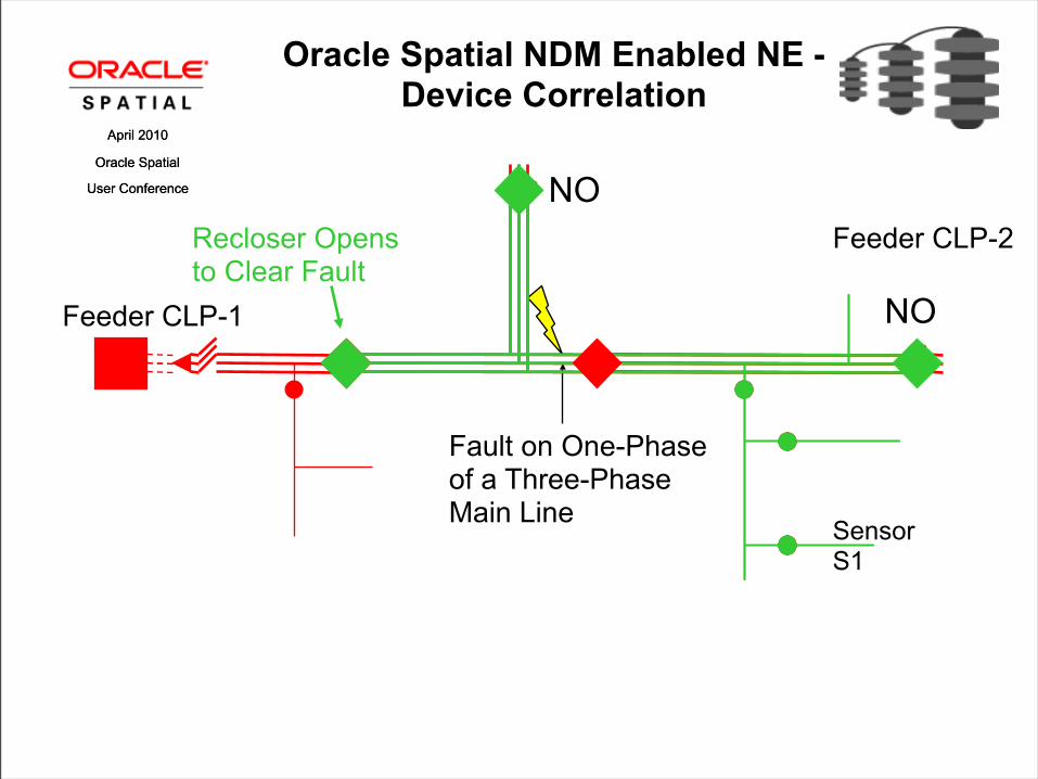
Feeder CLP-1
NO
Oracle Spatial NDM Enabled NE - Device Correlation
NO
Feeder CLP-2
Sensor S1

April 2010
Oracle Spatial
User Conference
April 2010
Oracle Spatial
User Conference
Feeder CLP-1
NO
Fault on One-Phaseof a Three-PhaseMain Line
Oracle Spatial NDM Enabled NE - Device Correlation
NO
Feeder CLP-2
Sensor S1
April 2010
Oracle Spatial
User Conference
April 2010
Oracle Spatial
User Conference
Feeder CLP-1
NO
Fault on One-Phaseof a Three-PhaseMain Line
Oracle Spatial NDM Enabled NE - Device Correlation
Recloser Opens to Clear Fault
NO
Feeder CLP-2
Sensor S1

April 2010
Oracle Spatial
User Conference
April 2010
Oracle Spatial
User Conference
Feeder CLP-1
NO
Fault on One-Phaseof a Three-PhaseMain Line
Oracle Spatial NDM Enabled NE - Device Correlation
Recloser Opens to Clear Fault
NO
Recloser opensTo Isolate Fault
Feeder CLP-2
Sensor S1

April 2010
Oracle Spatial
User Conference
April 2010
Oracle Spatial
User Conference
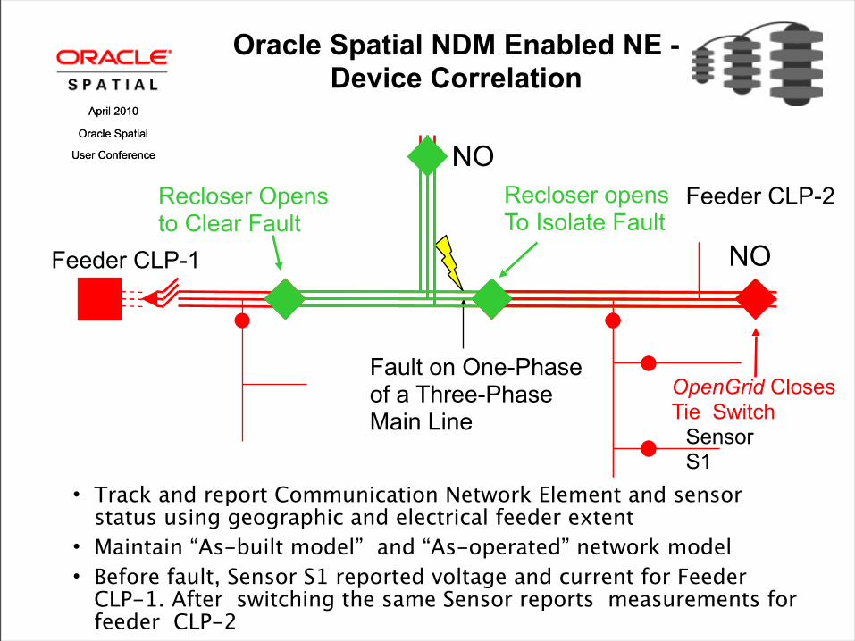
Feeder CLP-1
NO
Fault on One-Phaseof a Three-PhaseMain Line
Oracle Spatial NDM Enabled NE - Device Correlation
Recloser Opens to Clear Fault
OpenGrid Closes Tie Switch
NO
Recloser opensTo Isolate Fault
Feeder CLP-2
Sensor S1
April 2010
Oracle Spatial
User Conference
April 2010
Oracle Spatial
User Conference
Feeder CLP-1
NO
Fault on One-Phaseof a Three-PhaseMain Line
• Track and report Communication Network Element and sensor status using geographic and electrical feeder extent
• Maintain “As-built model” and “As-operated” network model • Before fault, Sensor S1 reported voltage and current for Feeder
CLP-1. After switching the same Sensor reports measurements for feeder CLP-2
Oracle Spatial NDM Enabled NE - Device Correlation
Recloser Opens to Clear Fault
OpenGrid Closes Tie Switch
NO
Recloser opensTo Isolate Fault
Feeder CLP-2
Sensor S1

April 2010
Oracle Spatial
User Conference
Spatial Powered Smart Grid
Legacy GIS• Requires dual architecture to
store data• Proprietary API and spatial
queries• Isolated system requires
extensive integration effort and data translation
• Often supports only single network
• Lacks built-in temporal features to take actionable intelligence using historic data
Oracle Spatial – CURRENT OpenGrid
• gIS – Unified data storage • SQL based spatial query
support• Enterprise system enables
ease of integration• Build-in support for OGC and
SQL• Multiple Network Support to
enable self-healing• Unified network topology,
real-time and historic data provide actionable intelligence to prevent faults

April 2010
Oracle Spatial
User Conference
Data Model Differences
Corporate GIS - As Built• Complex, numerous objects
& attributes• Emphasis on asset detail,
not speed• Many update users, each
with unique view• Includes proposed facilities• Static devices show nominal
status• New Smart Grid devices are
yet to be modeled
Smart Grid - As Operated
• Simplified, essential objects & attributes
• Emphasis on speed• Many operations users
share one view• Focus is on existing
facilities• Dynamic devices show
current status• Integrated Network models
enables association between Smart Grid devices and grid
April 2010
Oracle Spatial
User Conference
April 2010
Oracle Spatial
User Conference
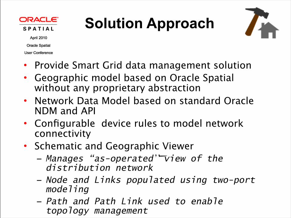
Solution Approach
• Provide Smart Grid data management solution• Geographic model based on Oracle Spatial
without any proprietary abstraction• Network Data Model based on standard Oracle
NDM and API• Configurable device rules to model network
connectivity• Schematic and Geographic Viewer
− Manages “as-operated” view of the distribution network
− Node and Links populated using two-port modeling
− Path and Path Link used to enable topology management

April 2010
Oracle Spatial
User Conference
April 2010
Oracle Spatial
User Conference
OpenGrid Data Sources
Path Links
Nodes
Links
Paths
NDM Metadata
OpenGrid User Data
April 2010
Oracle Spatial
User Conference
April 2010
Oracle Spatial
User Conference
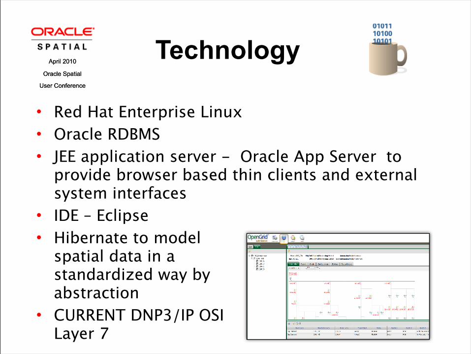
• Red Hat Enterprise Linux• Oracle RDBMS • JEE application server - Oracle App Server to
provide browser based thin clients and external system interfaces
• IDE – Eclipse• Hibernate to model
spatial data in a standardized way by abstraction
• CURRENT DNP3/IP OSI Layer 7
Technology
April 2010
Oracle Spatial
User Conference
April 2010
Oracle Spatial
User Conference
Architecture
• IEC 61968 CIM and OGC CIM inspired distribution data model
• Load-On-Demand Analysis to manage very large network analysis− Web client utilizes LOD Java API for network applications
− Spatial workspace for long term transaction and incremental import from the legacy GIS
− Periodic versioning of network data model to maintain network operations history
April 2010
Oracle Spatial
User Conference
April 2010
Oracle Spatial
User Conference
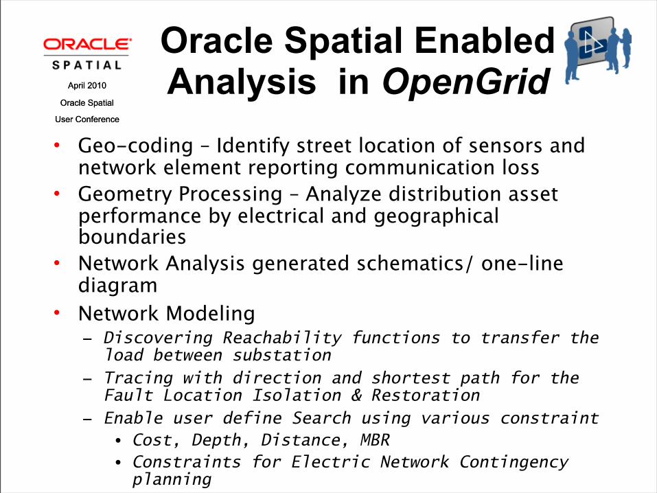
• Geo-coding – Identify street location of sensors and network element reporting communication loss
• Geometry Processing – Analyze distribution asset performance by electrical and geographical boundaries
• Network Analysis generated schematics/ one-line diagram
• Network Modeling − Discovering Reachability functions to transfer the
load between substation− Tracing with direction and shortest path for the
Fault Location Isolation & Restoration− Enable user define Search using various constraint
• Cost, Depth, Distance, MBR• Constraints for Electric Network Contingency planning
Oracle Spatial Enabled Analysis in OpenGrid

April 2010
Oracle Spatial
User Conference
April 2010
Oracle Spatial
User Conference
GIS Integration Process
• GIS Integration Methodology− Proven and standards based GIS integration process supports
multiple GIS data sources and formats− Supported Data Standards: XML, GML, IEC 61968-11 CIM, NRECA
MultiSpeak
April 2010
Oracle Spatial
User Conference
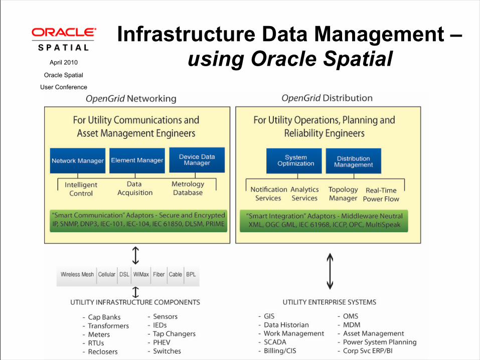
Infrastructure Data Management – using Oracle Spatial

April 2010
Oracle Spatial
User Conference
• Electric Grid View− Provides access to real-time electric grid status
− Historic data for analysis
− Real-Time Distribution Power Flow Analysis to optimize the power delivery
• Network View− Provides access to communication network status and configuration
− Root Cause Analysis of Network Elements
Spatial Network User Interface

April 2010
Oracle Spatial
User Conference
April 2010
Oracle Spatial
User Conference
Installation of sensing equipments, two-way communication network for distribution grid automation and real-time AMI to provide:
− Transformer Monitoring - real-time decisions based on current grid conditions
− Feeder Automation - monitoring power flow, outages and asset device health to provide centralized Volt-VAR control and Dynamic Voltage Optimization
− Smart Distribution System – real-time data on power consumption, outages, restoration and fault locations
Utilizing− Advanced sensing technology to monitor feeder condition− Two-way, low latency real-time
communications − Unified Communication and Electrical
grid topology management
SmartGridCityTM – Boulder, COSmart Grid Deployed – The Xcel Energy Example

April 2010
Oracle Spatial
User Conference
April 2010
Oracle Spatial
User Conference
System detected fault current and sent fault alarms indicated the
location of the cable failure
SGC– MV Fault Location Detection

April 2010
Oracle Spatial
User Conference
April 2010
Oracle Spatial
User Conference
• Connectivity model import from proprietary GIS data models to Spatial Network Model
• Temporal support to track network model changes over the time
Spatial Feature Wish List

April 2010
Oracle Spatial
User Conference
Summary
• Oracle Spatial is a core component of OpenGrid’s unified communication and electrical topology management to deploy the Smart Grid solution
• Unified networks enables self-healing and optimized distribution network operations Asset Management, Strategic Planning, Tactical deployment of sensors and visualization
• GML and CIM standards based GIS integration leads to − Removes limits imposed by proprietary data model
− Improves GIS data accessibility

AQ&April 2010
Oracle Spatial
User Conference