approaching the capitol: the story of the minnesota state capitol...
TRANSCRIPT

When the Minnesota State Capitol opened in 1905, it overlooked a vastly different setting. At
the time, an asymmetric grid of streets, modest buildings, billboards, and vacant lots surrounded the area. Capitol architect Cass Gilbert spent almost the next 30 years, until the end of his life, advocating for a grand capitol approach that would do justice to his building’s design.
The decades- long struggle to realize Gilbert’s plans reflected the competing financial and political interests of the State of Minnesota, the City of St. Paul, and Ramsey County, as well as St. Paul business interests. While the
state legislature had appropriated funds and authorized bonds to construct the capitol in accordance with Gilbert’s vision, legislators had little interest in authorizing the acquisition of nearby properties to implement a grander scheme, whether for a war memorial or to expand the facilities of state government. Gilbert’s capitol approach plan followed the Beaux- Arts precedents of the Chicago World’s Columbian Exposition (1893) and the McMillan Plan for a park system in Washington, DC (1902). Both had drawn inspiration from European cities and eighteenth- century gardens.
Clearing the site of the state capitol approach at Wabasha Street and Tenth Street, August 13, 1953.
MARJORIE PEARSON
Approaching the Capitol THE STORY OF THE MINNESOTA
STATE CAPITOL MALL
MARJORIE PEARSON, PhD, is senior architectural historian with Summit Envirosolutions, based in St. Paul. She served for 20 years as director of research at the New York City Landmarks Preservation Commission. There she gained firsthand knowledge of the New York work of Cass Gilbert. She is a past president of the Cass Gilbert Society.
The City of St. Paul and the larger business community did embrace Gilbert’s vision but balked at the large amount of land to be acquired at the city’s expense. Gilbert’s ideas were incorporated into two larger city plans for St. Paul, proposed in 1911 and in 1922. Both were promoted in part by local business interests, but neither plan was formally adopted. Despite ongoing deterioration in the blocks around the capitol and even national ridicule over the unsightly setting, it was not until the end of World War II that city and state interests would finally align to imple-ment a plan for the State Capitol Mall. Designed by the landscape architecture firm of Morell and Nichols, this plan partially realized Gilbert’s vision of landscaped grand boulevards providing axial approaches to the capitol.
Today’s capitol was preceded by two earlier build-ings. Both occupied a confined site in downtown St.
Paul on the block bounded by Wabasha, Exchange, Cedar, and West Tenth Streets. The first was constructed in 1853 as the territorial capitol; it became the state capitol in 1858 and was expanded in 1874 and 1878. Following a fire in 1881 that destroyed the building, the second capitol was constructed in 1882–83 on the same site.1 It remained in place until 1938. From the day the second capitol opened, it was judged inadequate.
As planning for a third and larger capitol began in 1891, the Board of State Capitol Commissioners sought a more expansive site to the north, up the hill from down-town. Given the constraints of budget and the challenges of land acquisition, there was no intention of creating “approaches” or a landscaped setting for the building. After several months of negotiations with the property owners, in October 1893 the commissioners acquired an irregularly shaped plot known as the Wabasha Street site— bounded by University Avenue on the north, Cedar Street on the east, Park Avenue (later Park Street) on the west, and the intersecting diagonals of Central Avenue and Wabasha Street on the south. University Avenue was the main east- west route between St. Paul and Min-neapolis, and new electrified streetcar lines served both Wabasha Street and University Avenue. The site was on elevated ground with only three mapped blocks and very few buildings north of the existing capitol building.2
Front curb of the capitol during construction, ca. 1900.
State capitol site from Wabasha Street, ca. 1896.
In 1894 two civil engineers and land surveyors, Thomas Milton Fowble and J. Henry Fitz, prepared a site plan that depicted the building facing south and approached by a central drive leading from Wabasha Street. After a failed attempt to find a suitable architect through an open competition, the Board of State Capitol Commissioners launched a second, invitation- only competition in 1895. This time, Cass Gilbert was declared the winner. His design depicted no approaches, only terraced steps and a circular carriage drive.3
In accordance with the competition requirements, Gilbert’s initial design included a rather modest setting for the new capitol, but he later amended his contract to include the landscaping around the building, overseeing the “embellishment of the grounds constituting the site of
W I N T E R 2 0 1 6 – 1 7 121

said State Capitol.” After the existing buildings were demolished and the site was graded and prepared for con-struction, a formal groundbreaking ceremony took place on May 6, 1896.4 Midway through the construction, in December 1900, Gilbert asked his draftsman and delineator, Thomas R. Johnson, to paint a watercolor of the capitol complete with terraces and approaches. The rendering was pre-sented to Channing Seabury, the vice president of the Board of State Capitol Commissioners, at a meeting in Feb-ruary 1901. Johnson depicted the site with expansive lawns and a central approach lined with statuary set on multilevel terraces.5
What led Gilbert to think about the Minnesota State Capitol in a larger setting? The domed building followed the precedent that had been set by the US Capitol, but the imme-diate setting in Washington, DC, was less than impressive throughout the nineteenth century. In 1893, however, the World’s Columbian Exposition in Chicago heightened the ambitions of architects and urban planners in the United States. Built to showcase neoclassical architectural splendor, the fairgrounds included the Court of Honor, which faced a reflecting pool headed by the domed Administration Building. Gilbert also admired the Rhode Island State House, designed by the New York firm of McKim, Mead, and White just a few years before Gilbert submitted his Minnesota design.6 Historians Henry- Russell Hitchcock and William Seale have characterized the two: “The Capitols of Minnesota and Rhode Island were both completed in the first decade of the twentieth century. They became important models which were never really copied, but which loomed behind every other project of that kind for a whole generation.”7
The Rhode Island State House and the Minnesota State Capitol were constructed over the same period of time. They share the same design vocabulary, planning features, and certain site features. Ground was broken for the Rhode Island State House on September 16, 1895; Minnesota broke ground on May 6, 1896. Both buildings opened in 1905. Each was constructed on a hill overlook-ing its respective downtown. The Public Park Association
of Providence called for a 300- foot- wide landscaped boulevard to link the Rhode Island State House to the new Union Station downtown, although the boulevard was only partially realized and the plans for the terrace approaches and grounds were not approved until 1904.8 In contrast, the Minnesota State Capitol site was acquired in isolation with no intent of forging a larger connection with the commercial city. Gilbert visited Providence sev-eral times while both the Rhode Island and Minnesota capitol buildings were under construction and gained further appreciation of the importance of an expansive landscaped setting. Both the World’s Columbian Exposi-tion and the Rhode Island State House and its landscape proposals helped to set the stage for the City Beautiful movement of the early twentieth century.9
In 1899 Gilbert had established a New York City office to oversee the construction of his designs for the Broadway Chambers Building and the US Custom House.
Fowble and Fitz, “New Capitol Site, showing location of builidng and arrangement of grounds with the necessary grades,” 1894.
122 M I N N E S OTA H I S TO RY

While in New York he became increasingly involved in the affairs of the American Institute of Architects (AIA) and formed a friendship with Glenn Brown, secretary of the national organization. Brown, working through the AIA, was developing support to create the National Mall in Washington, DC, and brought Gilbert into the process. Barbara Christen, a noted Gilbert scholar, asserts that this involvement is what led Gilbert to begin developing his various approach plans for the Minnesota State Capitol after 1900.10
Meanwhile, Channing Seabury and the other members of the Board of State Capitol Com-
missioners struggled to convince the Minnesota State Legislature to provide adequate funding for the new building. By 1900 the structure was well underway, and the exterior was largely complete by the end of 1902. In
mid- 1902, Gilbert tabulated the costs for grading, sodding, and planting the site, as well as for completing the steps and terraces. Dealing with the larger surroundings to the south of Wabasha Street and Central Avenue was outside the purview of the board.11
Instead, broader interest came from the citizens of St. Paul, most immediately in the form of the Women’s Civic League, which promoted interest in the arts and in civic betterment in the form of cleaner streets, alleys, and vacant lots. Gilbert was invited to present a lecture to the Women’s Civic League and the Commercial Club on the area around the capitol and what the city should do to improve it. Appealing to his civic audience, Gilbert gave his talk, “The Possibilities of St. Paul with Reference to the Approaches to the New Capitol,” on November 12, 1902. He illustrated the lecture with a plan depicting an open plaza in front of the building bounded by a curvilinear Central Avenue, an approach leading south from Central Avenue
Groundbreaking for the state capitol on May 6, 1896, Channing Seabury, vice president, Board of State Capitol Commissioners, with shovel.
W I N T E R 2 0 1 6 – 1 7 123

to a square at Park Place between Summit and College Avenues and between St. Peter and Rice Streets, and another group of civic buildings located to the southeast by the site of the old capitol and linked to the new capitol by a wide approach along Wabasha and Cedar Streets. (This southeast axial plan is similar to the approach plan that linked the Rhode Island State House and Union Sta-tion.)12 Space for two new buildings was reserved to the north of the cap-itol on University Avenue. Gilbert’s plan established a clear axial rela-tionship between the new capitol and downtown St. Paul. The editors of the St. Paul Pioneer Press proclaimed that St. Paul had a duty to create a more expansive setting because the beauty of the new building deserved it. Soon after Gilbert’s lecture, a new commit-tee was formed with representatives from a variety of business and civic organizations to promote interest in Gilbert’s plan for the approaches to the capitol.13
In 1903 Gilbert prepared the “Original Ideal Group Plan,” his most comprehensive and widely published scheme for the capitol site. Christen characterizes it as “a model for what was possible in other cities and other City Beautiful–oriented projects.”14 On December 11, 1903, Gilbert submitted the plan to the St. Paul Board of Park Commissioners with a presentation that also included the development committees of the Commercial Club, the Chamber of Commerce, and the Women’s Civic League. Building on his 1902 plan, Gilbert added an approach to the southwest leading to St. Anthony Hill, a site that was being discussed for the St. Paul Cathedral (built 1906–15). This 1903 addition was later characterized by Pioneer Press editor Webster Wheelock: “This approach will afford a vista between the two most imposing and beautiful buildings of the city.” The approach leading directly to the south paused at the square at Park Place. This square would retain an important place in successive capitol approach plans. According to Wheelock: “The site of this square is commanding, for at this point, after a gradual descent from the capitol, there is a drop of some twenty- five feet to a lower level. This break in the avenue will not only interrupt the vista of the capitol, but will afford the
opportunity for a special treatment which will add greatly to the beauty of the approach.”
The approach then extended even farther to the south to the downtown area known as Seven Corners. A park-way connection was added at the northwest to lead along Como Avenue to Como Park. Gilbert’s plan placed great emphasis on vistas to and from the elevated topography of the capitol site.15
Gilbert accompanied the 1903 plan with a detailed description as well as a strategy for implementing the pro-posed approaches. He was concerned that they be a city expense, not a state one, to avoid further controversy over ongoing funding for the capitol building and its imme-diate setting. He knew that the implementation of the approach plan would be expensive because so much prop-erty needed to be purchased. This meant it would have to be carried out over a period of years. The local newspapers were enthusiastic, seeing the possibilities in making St. Paul an exemplar of the City Beautiful movement.16 Gilbert’s plan received national publicity, as well, and he was asked to submit it for publication in The Existing and
Cass Gilbert plan for capitol approaches, 1903. Published in Andrew Wright Crawford and Frank Miles Day, The Existing and Proposed Outer Park Systems of American Cities: Report of the Philadelphia Allied Organizations (1905).
124 M I N N E S OTA H I S TO RY

Proposed Outer Park Systems of American Cities: Report of the Philadelphia Allied Institutions (1905).17
Despite the broad appeal and support for the vision portrayed in Gilbert’s plan, neither the citizens of St. Paul nor the state legislature were willing to pay for its imple-mentation. As the capitol neared completion in 1905, it sat on a grassy slope traversed by steps and terraces and bounded by Park Avenue, University Avenue, Cedar Street, and the diagonal routes of Wabasha Street with its street-car tracks and Central Avenue at the base of the lawn. Nearby blocks contained a variety of low- scale residential and commercial buildings, as well as billboards and vacant lots.18 In August 1905, Archbishop John Ireland officially announced that the new cathedral would be constructed on St. Anthony Hill at the intersection of Summit and Selby Avenues to the southwest of the capitol, thus rein-forcing the proposed southwest capitol approach.19
Webster Wheelock of the Pioneer Press was a strong advocate for Gilbert’s plan and helped convince the St. Paul Common Council to create the Capitol Approaches Commission to study and promote the plan. Both he and Gilbert served on the commission, and they co- authored the 1906 Report of the Capitol Approaches Commission to the Common Council of the City of St. Paul. The report included a map of the approaches, the 1903 “Original Ideal Group
Plan,” and a summary of the commission’s findings and recommendations, emphasizing that the city of St. Paul should bear the burden of land acquisition but that the state also had a responsibility:
[We assume that] the state, which is proud of the Capitol and which finds its beauties hidden amid squalid sur-roundings, will be willing to do what it can to give the building such a setting as its exquisite lines and propor-tions demand. . . .
[The state] with the finest Capitol building in the United States and one of the most beautiful buildings in the country cannot afford to let it remain amid such sur-roundings as those which now cheapen it and detract from its splendor.20
Lavish photographs of grand boulevards, squares, and public gardens from European cities were contrasted
Building on his 1902 plan, Gilbert added an approach to the southwest leading to St. Anthony Hill, a site that was being discussed for the St. Paul Cathedral.
Minnesota State Capitol as seen from the southeast, ca. 1906.

Map of proposed capitol approaches, 1906. From Webster Wheelock, “Re- Setting Minnesota’s Capitol,” Charities and the Commons, February 1, 1908.
with bleak photographs of the proposed area for the approaches that depicted the modest and often deterio-rated buildings. The report advocated fiscal prudence and noted the plan’s potential to improve tourism. It proposed acquiring the necessary property through bonds and argued that increased property tax assessments would be more than offset by enhanced property values.
Meanwhile, Gilbert prepared more detailed drawings for the City of St. Paul.21 Although
neither the city nor the state was prepared to move for-ward with the plans completely, in 1907 the legislature authorized yet another entity, the State Capitol Grounds Commission, to oversee the area around the capitol. That year, the state began to purchase some of the privately owned land and buildings along Wabasha Street for inclu-sion in the capitol grounds, and the Capitol Approaches Association, a public- private group that was an outgrowth of the Capitol Grounds Commission, was formed to con-tinue to press for the implementation of the plans.22
In 1911 the City of St. Paul teamed up with a private civic organization to hire landscape architects John Nolen and Arthur E. Comey. They prepared a plan for the City of St. Paul that was presented to the St. Paul City Plan Commission. Much of Nolen’s and Comey’s attention was
focused on what they called the Central District encom-passing downtown St. Paul and the area leading to the capitol, which was labeled the Administrative Section. Their work acknowledged Gilbert’s plan and followed its precedent with the incorporation of three approaches to the southeast, southwest, and south that would lead to Monument Park at the site of Park Place, as well as provide sites for new state buildings. Although this plan was well received, it was never formally adopted by the city.23
The state took the next step in expanding its footprint beyond the immediate capitol grounds in 1916 to 1918, when it constructed the Minnesota Historical Society building (which had outgrown its space in the capitol) on Cedar Street, southeast of the capitol, along Gilbert’s pro-posed southeast approach.24
After World War I, increased interest in creating a war memorial at Park Place meshed with Gilbert’s southern approach leading to Park Place. Gilbert’s son and architec-tural partner, Cass Gilbert Jr., began promoting his father’s plan, emphasizing the southern approach. He also stressed the importance of developing a city plan to guide future “rational growth along reasonable, economic lines.” He
126 M I N N E S OTA H I S TO RY

noted, “Had St. Paul started on the capitol approach plan as laid out by Cass Gilbert in 1907, the city would have had less expense at the start as there were then fewer big buildings on the property to be taken over.” He urged that the time had come to acquire the land needed both for the approach plan and for future state office buildings. Future land costs would only escalate.25
In 1921 Governor J. A. O. Preus appointed the State War Memorial Commission, which later affirmed Park Place as a good location for a war memorial. St. Paul architects Allen H. Stem and Roy Haslund prepared a rendering that illustrated a memorial obelisk. Despite the interest and the younger Gilbert’s warning about rising property costs, nothing came of the proposal. The state, county, and city continued in conflict over who should pay for even this more modest effort.26
The City of St. Paul still had ambi-tions for an overall plan, following the example that had been set by the Plan of Chicago (1909) and the Plan of Minneapolis (1917). George H. Herrold, a graduate of the University of Min-nesota School of Engineering, was appointed director of the St. Paul City Planning Board in 1920. A proponent of Gilbert’s capitol approach plan, Her-rold immediately began to collaborate with Chicagoans Edward H. Bennett, who had worked on the Chicago and Minneapolis plans, and William E. Parsons to produce the Plan of Saint Paul, submitted to the “Citizens by the City Planning Board” in 1922. The Plan of Saint Paul largely adopted Gilbert’s approaches to the capitol and reproduced many of the 1907 drawings and photographs.27
Discussions continued about who should pay for the plan. The City of St. Paul’s governmental structure and budget constraints imposed limits on the city’s support. After much lobbying by the United Improve-ment Council (a group formed in 1927 to promote a civic building program) St. Paul and Ramsey County voters approved bonding bills of $7.5 million in 1928 for capital improvements.28
Meanwhile, the neighborhood around the cap-itol had continued to deteriorate during the 1920s.
Hoping to capitalize on the new bonding program, the St. Paul Daily News ran a series of “picture editorials,” begin-ning in February 1929, to illustrate the billboards, shacks, burned- out houses, and other nuisances around the capi-tol. It called for immediate action:
What an imposing building the Capitol is, and how well proportioned! It is an artistic and architectural triumph of which any state could well be proud. . . . The trouble
Proposed boulevard from Seven Corners to state capitol; Park Place and war memorial site are in the middle ground. From the Plan of Saint Paul (1922), created by George H. Herrold, Edward H. Bennett, and William E. Parsons.
W I N T E R 2 0 1 6 – 1 7 127
with it is that not everybody can take to the air to get a good view of it. And without an airplane, the Capitol is hard to see because of the screen of ugliness which com-pletely surrounds it. . . . It would be more than worth the cost to provide approaches from which the Capitol could be seen from the ground. Until this is done Min-nesota’s architectural jewel will indeed be lost amidst the swinish surroundings.29
Despite such pleas, again nothing was done as the city dealt with more pressing infrastructure and building concerns.
While the city did nothing, the state realized that it needed additional office space and began investigating sites for a new building north of the capitol, space that Gilbert had wanted left open. Because of concern about the proposed location, local civic and government groups agreed to hire Gilbert’s firm, Cass Gilbert Inc., to review the plans and make recommendations about the place-ment of the new building in relation to earlier approach plans. In September 1930 the two Gilberts toured the site and met with Governor Theodore Christianson and representatives of the local civic and government groups. The firm’s report, issued in February 1931, cited the 1906 report and Gilbert’s 1907 drawings, and was illustrated with perspective sketches and a bird’s- eye view of a plan for the approaches to the capitol. The latest plan, which had been updated to reflect urban growth and changes in traffic conditions, still emphasized a strong axial approach leading south from the capitol to a monument at Park Place. This path then continued past Seven Corners to a new Bridge Plaza and on to a site on the west side of the Mississippi River where the approach would terminate at a monument to the [European- American] “pioneers.” The
site of the historical society building was shown on the east side of Cedar Street. A location for the state office building was shown on the west side of Park Avenue (later Park Street), just to the south of Aurora Avenue, which continued eastward to span the plaza immediately to the south of the capitol steps. Sites were reserved for land-scaped open parkland, both north of University Avenue and to the south of Central Avenue. The approaches were lined with symmetrically placed, classically inspired office buildings no higher than four stories to avoid overshad-owing the capitol.30
While the overall scheme remained unrealized, plans for the state office building proceeded in the new location proposed by Gilbert to the west of the capitol. The office building, designed by Clarence H. Johnston, was con-structed in 1932, and several park areas were added south and west of the capitol.31
As the Great Depression dragged on, the residential blocks to the south, east, and west became increasingly deteriorated. Residents and visitors to the city regularly wondered how to improve the area. A notorious article that unfavorably compared St. Paul with Minneapolis in
Surroundings southwest of the state capitol in 1945.
In 1941 a confluence of forces— local, state, and national— helped revive the discussion of capitol approaches.
128 M I N N E S OTA H I S TO RY

Fortune magazine (1936) was accompanied by a Ludwig Bemelmans watercolor illustration that depicted the cap-itol rising above the local slums, called “among the worst in the land.”32 Responding to the criticism, the City of St. Paul acquired some property around the capitol in 1939 to improve the surroundings.33
In 1941 a confluence of forces— local, state, and national— helped revive the discussion of cap-
itol approaches. Newly elected St. Paul mayor John J. McDonough appointed the United Civic Council to study major urban issues and plan for St. Paul’s future. In 1944 the St. Paul Planning Board announced that a plan for capitol approaches and a war memorial should take pre-cedence over other civic improvements after World War II ended. Planning board director George Herrold proposed hiring Clarence H. Johnston Architectural Associates (Johnston himself had died in 1936) and the landscape architecture firm Morell and Nichols to produce a plan. This was a good team to oversee development of the cap-itol approaches. The Johnston firm had been involved with the capitol and its surroundings since 1915. By 1944, Morell and Nichols was probably the most respected land-scape architecture firm in Minnesota.
The plan developed by the Johnston and Nichols firms incorporated key elements of Gilbert’s earlier plan, calling for boulevards that radiated to the southwest toward the cathedral and to the southeast along Cedar Street. Instead of reaching to Seven Corners, the south axial approach would terminate at the proposed location of the war memorial north of Park Place. Herrold felt that such a plan would be easier for the legislature to approve because it required less property acquisition. The plan also antici-pated a new “national defense” highway (today’s Interstate 94), then in the planning stages, extending through down-town St. Paul. The planning board presented the proposal to the State War Memorial Advisory Committee. Early in 1945 Governor Edward Thye appointed the Veterans Service Building Commission to supervise a competi-tion for a veterans’ memorial building. The legislature then appropriated funds for the new building and for the enlargement and improvement of the capitol grounds, while the City of St. Paul was authorized to sell bonds to fund the acquisition of land around the capitol grounds to rearrange the street system.34
With funding in place, Arthur Nichols and George Nason of Morell and Nichols refined their 1944 plan and proposed a location for the veterans service building. After W. Brooks Cavin Jr. won the competition for the new building in 1946, Nichols and Nason further improved
1902 “The Possibilities of St. Paul with Reference to the Approaches to the New Capitol” presented to the Women’s Civic League and the Commercial Club by Cass Gilbert.
1903 “Original Ideal Group Plan” by Cass Gilbert submitted to the St. Paul Board of Park Commissioners.
1905 “Original Ideal Group Plan” published in The Existing and Proposed Outer Park Systems of American Cities (p. 124).
1906 A map of the proposed capitol approaches and the “Original Ideal Group Plan” included in Report of the Capitol Approaches Commission to the Common Council of the City of St. Paul, and in another 1908 report (p. 126).
1907 Additional plans and drawings for the City of St. Paul.
1911 A plan for St. Paul presented to St. Paul City Plan Commission incorporates Gilbert’s plan for capitol approaches.
1917 Plan of Minneapolis reproduces Gilbert’s unrealized capitol approach plans (1907) as an example of what could be done in Minneapolis.
1921 “A Boulevard Development for St. Paul by Cass Gilbert, Architect,” illustrated with 1907 plans, published in The Park International.
1922 Plan of Saint Paul by St. Paul City Planning Board reproduces many of Gilbert’s 1907 drawings and photographs (p. 127).
1923 State War Memorial Commission recommends Park Place on the proposed south approach as the location for a war memorial.
1931 Report on Capitol Approaches by Cass Gilbert Inc. com-missioned by St. Paul Association, the St. Paul City Council, the Ramsey County Commissioners, and the St. Paul Planning Board, updates 1906 report and 1907 drawings; adds drawings that extend the central approach to the west side of the Missis-sippi River.
1944–46 Plans for capitol area by Morell and Nichols, with elements from Gilbert’s vision (p. 130, 131).
1951–55 State Capitol Mall finally built, partially fulfilling Gilbert’s vision.
1970 Comprehensive plan by Interpro Inc. presented to Capitol Area Architectural and Planning Commission.
1988 Project for the Completion of the Capitol Mall, St. Paul, Minnesota by David T. Mayernik and Thomas N. Rajkovich.
1998 Comprehensive Plan for the Minnesota Capitol Area by Zimmer Gunsul Frasca Partnership.
2009 July 2009 Amendment to the 1998 Comprehensive Plan for the Minnesota State Capitol Area by Sanders Wacker Bergly Inc.
Chronology of Capitol Approach Plans

their plan. They identified locations for two new state buildings facing the Cedar Street Mall, proposed Sum-mit or Cathedral Mall, and eliminated the diagonal of Wabasha Street across the lawn, incorporating it into the reconfigured and curvilinear Central Avenue. The plan also included an axial pedestrian mall leading from the capitol steps and terminating at a “court of honor,” and a curvilinear Thirteenth Street (renamed Columbus Street in 1953) to the north of the Veterans Service Building site, which faced onto Twelfth Street. Nichols explained: “We placed major emphasis upon two diagonals radiating from the capitol. Both of these diagonals would be divided road-
ways with a central park strip thus each accommodating one way traffic on either side. They formulate the two sides of a fan shaped area with the Capitol as the Apex and the proposed circular street fronting the Service Building as the lower rim of the enclosure.”35
Following approval of the plan, both the state com-mission and the City of St. Paul began to acquire property.
A preliminary layout study for a “Minnesota State Center and War Memorial,” 1944, prepared for the St. Paul Planning Board by Morell and Nichols. The classical building envisioned at bottom left became the site of the modern Veterans Service Building (1953–54, 1973).
When the capitol was sited in 1894, it was laid over the intersecting and often confusing grid of the streets of St. Paul. This grid is depicted on the various superimposed approach plans produced by Gilbert’s office over the course of 30 years. When the Morell and Nichols plan was finally executed in the 1950s,
some existing streets were completely removed and new streets were installed, while several existing streets were reconfigured and subsequently renamed. The construction of Interstate 94 south of the capitol grounds removed even more streets. Other street closings have taken place under the jurisdiction of the
Capitol Area Architectural and Planning Commission. Vehicular traffic and on- street parking have been removed, with these streets being converted to pedes-trian walkways. As part of the current capitol restoration project, parking has been removed from Aurora Avenue and along the east side of the building.
The Streets of the State Capitol Mall

The Nichols plan called for extensive street rearrange-ment accompanied by building demolition. Clearance began in 1950 for the malls along the Cedar approach and the cathedral approach, followed by the construction of new streets, sidewalks, and lawn panels. To accommo-date this work, 75 structures were demolished, including two churches, several apartment buildings, and “many sub- standard private homes.” Beginning in 1950, Central Avenue was reconfigured in its curvilinear form, which incorporated the section of Park Street west of the capitol. The pedestrian mall leading from the front of the capitol to the Court of Honor was built at the same time.
In 1953 construction began on the Veterans Service Building, located 1,200 feet south of the capitol and just north of Park Place, with the auditorium and service wing on the west, and an L- shaped office wing on the east. (The three- story office block connecting the two wings was not completed until 1973.) With the work largely complete by 1955, the campus that became known as the State Capi-tol Mall assumed the overall form that still provides the
setting for the Minnesota State Capitol. The vision of a unified capitol approach plan was finally being realized. It was further supported by the growing state government that required new buildings. Over the next decade new state buildings were constructed largely in accordance with the Nichols plan.36
In 1957 the legislature established a commission to study the state’s physical plant. The Transportation
Building (1957–58) and the Centennial Building (1958–60) were located on the sites identified in the Nichols plan. In 1961 the commission also authorized the construction of a new armory to the east of Cedar Street at Columbus Avenue, thus preserving the openness of the vistas to and from the capitol. That same year, Cathedral Boulevard was renamed John Ireland Boulevard. In 1963 the commis-sion recommended the acquisition of property north of
Overall plan of proposed development, Morell and Nichols, 1946.
W I N T E R 2 0 1 6 – 1 7 131

University Avenue at Cedar Street to construct a new state administration building on land that Gilbert had called to be left open. The new building was completed in 1966. Simultaneously, Interstate 94 was being constructed in a depressed cut south of the capitol grounds, obliterating Park Place and largely severing the physical connection between the capitol and downtown.37
In 1967 the Capitol Area Architectural and Planning Commission (renamed a board, CAAPB, in 1975) was established “to preserve and enhance the dignity, beauty, and architectural integrity of the capitol, the buildings immediately adjacent to it, the capitol grounds, and the capitol area.” Since its establishment, the CAAPB has overseen and commissioned several changes to the Nich-ols plan, both to enhance the human scale of the State Capitol Mall and to provide an orderly process for the location and design of new state buildings. These changes have included a 1970 comprehensive plan proposed by the architectural firm Interpro Inc. (the architectural collab-oration formed by Haarstick, Lundgren and Associates; Grover Dimond and Associates; and Cerny Architects) and endorsed in a 1975 plan by landscape architect Dan Kiley
that resulted in the closing of several streets, converting them to landscaped pedestrian walkways.38
In 1984 the legislature authorized a new judicial center building on the site of Mechanic Arts High School, to be constructed adjacent to and incorporating the historical society building. Designed by Leonard Parker Associates, the new Judicial Center opened in phases between 1989 and 1994.39 Between 1987 and 1992 the bridges over Inter-state 94 along John Ireland Boulevard, St. Peter Street, Wabasha Street, and Cedar Street were replaced and incor-porated gatehouses, obelisks, and balustrades that reflect the historic character of the capitol building, thanks to another plan for the Capitol Mall developed by Hammel Green and Abrahamson (HGA) in conjunction with architect–urban designers David Mayernik and Thomas Rajkovich.40
In 2006 a new light- rail transit line called the Central Corridor Project began construction on a route to connect downtown St. Paul and downtown Minneapolis. In down-
View of the capitol approach from the southeast along Cedar Street, 1953.
132 M I N N E S OTA H I S TO RY
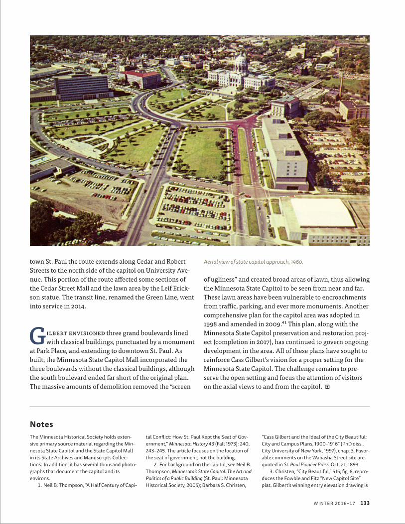
town St. Paul the route extends along Cedar and Robert Streets to the north side of the capitol on University Ave-nue. This portion of the route affected some sections of the Cedar Street Mall and the lawn area by the Leif Erick-son statue. The transit line, renamed the Green Line, went into service in 2014.
Gilbert envisioned three grand boulevards lined with classical buildings, punctuated by a monument
at Park Place, and extending to downtown St. Paul. As built, the Minnesota State Capitol Mall incorporated the three boulevards without the classical buildings, although the south boulevard ended far short of the original plan. The massive amounts of demolition removed the “screen
of ugliness” and created broad areas of lawn, thus allowing the Minnesota State Capitol to be seen from near and far. These lawn areas have been vulnerable to encroachments from traffic, parking, and ever more monuments. Another comprehensive plan for the capitol area was adopted in 1998 and amended in 2009.41 This plan, along with the Minnesota State Capitol preservation and restoration proj-ect (completion in 2017), has continued to govern ongoing development in the area. All of these plans have sought to reinforce Cass Gilbert’s vision for a proper setting for the Minnesota State Capitol. The challenge remains to pre-serve the open setting and focus the attention of visitors on the axial views to and from the capitol.
NotesThe Minnesota Historical Society holds exten-sive primary source material regarding the Min-nesota State Capitol and the State Capitol Mall in its State Archives and Manuscripts Collec-tions. In addition, it has several thousand photo-graphs that document the capitol and its environs.
1. Neil B. Thompson, “A Half Century of Capi-
tal Conflict: How St. Paul Kept the Seat of Gov-ernment,” Minnesota History 43 (Fall 1973): 240, 243–245. The article focuses on the location of the seat of government, not the building.
2. For background on the capitol, see Neil B. Thompson, Minnesota’s State Capitol: The Art and Politics of a Public Building (St. Paul: Minnesota Historical Society, 2005); Barbara S. Christen,
“Cass Gilbert and the Ideal of the City Beautiful: City and Campus Plans, 1900–1916” (PhD diss., City University of New York, 1997), chap. 3. Favor-able comments on the Wabasha Street site are quoted in St. Paul Pioneer Press, Oct. 21, 1893.
3. Christen, “City Beautiful,” 515, fig. 8, repro-duces the Fowble and Fitz “New Capitol Site” plat. Gilbert’s winning entry elevation drawing is
Aerial view of state capitol approach, 1960.
W I N T E R 2 0 1 6 – 1 7 133

reproduced in Sharon Irish, Cass Gilbert: Modern Traditionalist (New York: Monocelli Press, 1999), 39. Christen, “City Beautiful,” 513, fig. 6, repro-duces Hughson Hawley’s presentation drawing of 1896.
4. Thompson, Minnesota’s State Capitol, 21 (quote), 24 (on groundbreaking).
5. Christen, “City Beautiful,” 108, 181–182n50, 520, fig. 13. Gilbert made a pen and ink sketch titled “Study for Approach to Minnesota Capitol” while on the Lake Shore Limited on December 2, 1900. It was given to Channing Seabury and is now in the collections of the Minnesota Histori-cal Society. This sketch may also be the inspira-tion for the Johnson rendering, which is in the collections of the New-York Historical Society. The rendering was shown in an exhibition, “Min-nesota 1900: Art and Life on the Upper Missis-sippi 1890–1915,” held in 1994 at the Minneapolis Institute of Arts. It is reproduced in the exhibi-tion catalog, Michael Conforti, ed., Art and Life on the Upper Mississippi, 1890–1915 (Newark.: Univer-sity of Delaware Press, 1994).
6. Gilbert had worked for McKim, Mead, and White in New York City in 1880–82 before setting up his practice in St. Paul.
7. Henry-Russell Hitchcock and William Seale, Temples of Democracy: The State Capitols of the USA (New York: Harcourt Brace Jovanovich, 1976), 218.
8. Leland M. Roth, McKim, Mead and White, Architects (New York: Harper and Row, 1983), 150–155; Richard Guy Wilson, “Rhode Island State House,” in Buildings on Paper: Rhode Island Architectural Drawings, ed. William H. Jordy and Christopher P. Monkhouse, 115–118 (Providence: Brown University, Rhode Island Historical Soci-ety, Rhode Island School of Design, 1982); Rhode Island State House, Historic American Buildings Survey (HABS No. RI-155), Written and Historical and Descriptive Data, 2, Prepared by Deleuw, Cather/Parsons, Washington, DC, for US Depart-ment of Transportation, 1983.
9. Christen, “City Beautiful,” 100, 105–106; Roth, McKim, Mead and White, 155.
10. For background on Brown, Gilbert, and the Washington, DC, connections, see Christen, “City Beautiful,” chap. 2, 38 passim.
11. Christen, “City Beautiful,” 111.12. Wilson, “Rhode Island State House,”
116–117.13. Scott Lyle Koch, “Cass Gilbert’s Minne-
sota Capitol Approach Plan, 1902–1915” (MS thesis, Illinois State University, 1975), 88–96. Christen, “City Beautiful,” 116–123; 521, fig. 14, reproduces Gilbert’s “Study of Approaches.” See “St. Paul’s Duty to the New Capitol,” St. Paul Pio-neer Press, Nov. 14, 1902, 2, which also has photos that illustrate the surroundings that block the view; and “An Appropriate Setting for the New Capitol” (editorial), St. Paul Pioneer Press, Nov. 14, 1902, 6. Fowble and Fitz prepared a plat of the properties along Cedar and Wabasha, south of the capitol, along with costs to acquire them, Dec. 18, 1902. See Christen, “City Beautiful,” 523, fig. 16.
14. Christen, “City Beautiful,” 126.15. The 1903 plan was printed as “Original
Ideal Group Plan,” in Report of the Capitol Approaches Commission to the Common Council of the City of St. Paul (St. Paul: Pioneer Press, [1906]), plate opposite 1. A penciled notation in the Min-nesota Historical Society copy references neg. # 16026. See Christen, “City Beautiful,” 524, fig. 17. Webster Wheelock, “Re-Setting Minnesota’s Cap-itol,” Charities and the Commons 19 (Feb. 1, 1908): 1545–1546. This is one of a group of articles under the subtitle “The Practice of Planning.”
16. “Fit Setting for a New Capitol,” St. Paul Pioneer Press, Oct. 9, 1903, 2; “Fit Setting for Capitol,” St. Paul Pioneer Press, Dec. 10, 1903, 2; “Setting Worthy of Gem,” St. Paul Pioneer Press, Dec. 12, 1903, editorial section, 1; “Capitol Approaches,” St. Paul Dispatch, Dec. 12, 1903. Joseph Albert Wheelock, editor of the St. Paul Pioneer Press and father of Webster Wheelock as well as a member of the St. Paul Board of Park Commissioners, was a particularly strong advo-cate for Gilbert’s plans for St. Paul and the capi-tol approaches.
17. Arthur Wright Crawford and Frank Miles Day, The Existing and Proposed Outer Park Systems of American Cities: Report of the Philadelphia Allied Organizations (Harrisburg, PA: Mount Pleasant Press, 1905). As part of the submission, Gilbert prepared a detailed memo dated December 6, 1904, to accompany the “Original Ideal Group Plan.” The memo stated four objectives: to enlarge and make symmetrical the immediate surroundings of the capitol building; to open up the vista from the business district; to provide a line of approach from Summit Avenue to St. Anthony Hill; and to develop a broad avenue at right angles to the principal façade, extending directly south to Seven Corners. The appendix contains a “Description of St. Paul Group Plan, by Cass Gilbert: Memorandum Relating to Develop-ment of Approaches to the Minnesota Capitol, St. Paul,” 56–60. Thompson, Minnesota’s State Capi-tol, 100–101, cites the memo dated December 6, 1904, describing Gilbert’s 1903 plans. This is the same date as the appendix “Description”; see Christen, “City Beautiful,” 126–127, 193–194n135. Gilbert’s description was paraphrased in “Reveal-ing the Minnesota Capitol,” Architectural Record 18 (Dec. 1905): 480–481. See also Gary Phelps, His-tory of the Minnesota State Capitol Area (St. Paul: CAAPB, 1985), 13; an online version of Phelps is available at http://mn.gov/caapb/PDF/Complete %20History%20Document.pdf. Existing and Pro-posed Outer Park Systems described park systems in Hartford, Connecticut; Harrisburg, Pennsylva-nia; Providence, Rhode Island; and Washington, DC, that depicted capitol settings.
18. The City of St. Paul had acquired land in 1904 to widen Park Avenue from 60 to 100 feet, as well as the irregular block bounded by Park Avenue, University Avenue, St. Peter Street, and Wabasha Street, to create open park-like space to the west of the capitol. Christen, “City Beauti-ful,” 132–133, says it was necessary to acquire the land so the granite steps on the west side
could be constructed. See Koch, “Gilbert’s Min-nesota Capitol Approach,” 101–102, who cites “Approach to Capitol,” St. Paul Pioneer Press, Nov. 14, 1903, 2; “Widening Park Avenue” (editorial), St. Paul Pioneer Press, Nov. 15, 1903, second sec-tion, 6. Photographer Edmund D. Brush por-trayed the building in an extensive group of photographs that were published in a supple-ment to the October 1905 issue of The Western Architect, vol. 4. Glimpses of the residential sur-roundings can be seen in some of the exterior photographs.
19. Koch, “Gilbert’s Minnesota Capitol Approach,” 105n35, cites an unpublished letter from Archbishop John Ireland, in the St. Paul Col-lection, St. Paul Public Library. In his December 6, 1904, memo, Gilbert references discussions of the cathedral site. Emmanuel Masqueray had been retained as architect for the proposed new cathedral in March 1905. See Franklin T. Fergu-son, “The Cathedral of St. Paul,” Minnesota His-tory 39 (Winter 1964): 155.
20. Report of the Capitol Approaches Commis-sion to the Common Council of the City of St. Paul, 1, 19. A map of the proposed capitol approaches is placed on the inside cover: “This map shows the present plan of this section of the city. The terri-tory inside of the red lines indicating approaches and parkways to be acquired.” The Minnesota Historical Society copy has a penciled notation referencing neg. #15632. The capitol approach plan is discussed and the map reproduced in Charles Mulford Robinson, “Ambitions of Three Cities,” Architectural Record 21 (May 1907): 337–346. The other two cities are St. Louis and Boston, which were proposing ambitious park-way plans.
21. Phelps, History of the Minnesota State Cap-itol Area, 15–17. He states that negatives of photo-graphs of the drawings are in St. Paul Planning and Economic Development records, box 60, F.1.6F, in Minnesota State Archives, Minnesota Historical Society.
22. The triangle of the Wabasha Street Addi-tion, Block 1, located to the southwest of the main lawn, was purchased in 1913, and the Madi-son School and several other buildings on the site were demolished. The land was subse-quently seeded as part of the capitol lawn. Phelps, History of the Minnesota State Capitol Area, 17; Phase I and II Cultural Resources Investi-gations of the Central Corridor, Minneapolis, Hen-nepin County, and St. Paul, Ramsey County, Minnesota (St. Paul: Hennepin County Regional Railroad Authority, Ramsey County Regional Railroad Authority, Minnesota Department of Transportation, 1995), 7–70, 7–72; Koch, “Gilbert’s Minnesota Capitol Approach,” 126–127.
23. Phelps, History of the Minnesota State Cap-itol Area, 19; John Nolen and Arthur C. Comey, “Preliminary Plan of the Central District of Saint Paul, Report on the Tentative Plans for the Cen-tral District of Saint Paul. I. Administrative Dis-trict, II. Business Center” (1911), prepared under the direction of the City Planning Commission of the City of Saint Paul and the City Plan Commit-
134 M I N N E S OTA H I S TO RY

tee of the Saint Paul City Club. Printer’s proofs, available at Minnesota Historical Society.
24. Designed by Clarence H. Johnston, the state architect, the new building was located on property that the state had acquired about 10 years earlier. Paul Clifford Larson, Minnesota Architect: The Life and Work of Clarence H. Johnston (Afton, MN: Afton Historical Society Press, 1996), 138. The Minnesota Historical Society building is now incorporated into the Judicial Center, part of the Minnesota State Supreme Court complex. The historical society relocated to the Minnesota History Center on John Ireland Boulevard, off Kel-logg Boulevard, just downhill from the cathedral. Designed by Minneapolis architects Hammel Green Abrahamson, it opened in 1992. Nina M. Archabal, “The New Minnesota History Center: Looking Back at the Journey,” Minnesota History 53 (Fall 1992): 116–123.
25. Cass Gilbert Jr., “The ‘Capitol Approach Plan,’ A Boulevard Development for St. Paul by Cass Gilbert, Architect,” The Park International 2 (May 1921): 215–224. This journal was published by the Park Institute of America between July 1920 and May 1921 and featured articles by noted architects and landscape architects. When the younger Gilbert submitted this article, he wrote, “Mr. Gilbert is still very much alive,” and “the ‘Capitol Approach Plan’ may be interpreted by the author himself” (205). The article is illus-trated by Gilbert’s 1907 drawings for the City of St. Paul.
26. Phelps, History of the Minnesota State Cap-itol Area, 22; George H. Herrold, “Planning St. Paul from the Beginning,” unpublished type-script, 1958, 17–19, available at Minnesota Histor-ical Society.
27. The Plan of Minneapolis, prepared for the Minneapolis Civic Commission, reproduced Gil-bert’s unrealized capitol approach plan as an example of what could be done in Minneapolis. Gilbert’s office provided the drawings for repro-duction. Edward H. Bennett and Andrew Wright Crawford, Plan of Minneapolis (Minneapolis: Civic Commission, 1917), 26–27; “George H. Herrold Made Director of City Planning in St. Paul,” The Bulletin of the Affiliated Engineering Societies of Minnesota 5 (March 1920): 46; Edward H. Ben-nett, William E. Parsons, and George H. Herrold, Plan of Saint Paul: The Capital City of Minnesota (St. Paul: Commissioner of Public Works, 1922), 4, 7–8, 24–26; Phelps, History of the Minnesota State Capitol Area, 23–24; Jeffrey A. Hess and Paul Clifford Larson, St. Paul’s Architecture: A History (Minneapolis: University of Minnesota Press, 2006), 170.
28. Koch, “Gilbert’s Minnesota Capitol Approach,” 172–173, discusses the shift in govern-mental structure and implications for long-range funding and planning. For United Improvement Council, see Theodora Kimball Hubbard, Our Cities To-Day and To-Morrow, 1929: A Survey of Plan-ning and Zoning Progress in the United States (1929; reprint, London: Forgotten Books, 2013), 120.
29. “Screen of Ugliness,” St. Paul Daily News, Feb. 22, 1929.
30. St. Paul Dispatch, Sept. 14, 1930; Cass Gil-bert Inc. Architects, Report on Capitol Approaches (New York: Cass Gilbert Inc., 1931); Herrold, “Planning St. Paul,” 20–22. George F. Lindsay, chairman of the Capitol Approach Committee, submitted a copy of the report to Governor Floyd B. Olson, with a letter dated February 3, 1931, urging consideration of Gilbert’s recommenda-tion for the location of the new state office build-ing and noting the location was supported by the Nolen and Bennett plans. The letter is inserted in the copy of the report available at the Minne-sota Historical Society.
31. The triangle southwest of Wabasha Street was the site of the 1937 Winter Carnival Ice Palace. The triangle immediately to the west of the capitol became the site of the Leif Erick-son statue in 1949.
32. “Cass Gilbert Designed the Capitol; The Slums Got There Unaided” was the caption on the illustration. “Revolt in the Northwest,” For-tune 13 (Apr. 1936): 118.
33. The Ryan Building, on University Avenue to the west of the capitol, and the Capitol Laun-dry Building, on the south side of Wabasha Street at Rice Street and Aurora Avenue, were demolished. University Avenue was widened between Rice and Robert Streets, and Cedar Street was widened between Central Avenue and Thirteenth Street. Herrold, “Planning St. Paul,” 25; Insurance Maps of St. Paul, Minnesota (New York: Sanborn Map Company, 1926, updated 1939), vol. 1, sheet 59.
34. Hess and Larson, St. Paul’s Architecture, 170–171; Herrold, “Planning St. Paul,” 25–27; Arthur R. Nichols, “Development of State Capi-tol Approach, St. Paul, Minnesota, by State Vet-erans Service Building Commission, Morell & Nichols Inc.,” typescript, 1963, 2–3, available at Minnesota Historical Society. See also Judith A. Martin and Antony Goddard, Past Choices/ Present Landscapes: The Impact of Urban Renewal on the Twin Cities (Minneapolis: Center for Urban and Regional Affairs, University of Minnesota, 1989), 26–31.
35. Herrold, “Planning St. Paul,” 27–28; Nichols, “Development of State Capitol Approach,” 3–6; Hess and Larson, St. Paul’s Architecture, 180–181.
36. Nichols, “Development of State Capitol Approach,” 3–6; Hess and Larson, St. Paul’s Archi-tecture, 181; Larry Millett, AIA Guide to the Twin Cities (St. Paul: Minnesota Historical Society Press, 2007), 359; Larry Millett, AIA Guide to Downtown St. Paul (St. Paul: Minnesota Historical Society Press, 2010), 78–79. Herrold, “Planning St. Paul,” 28, commented on why it took so many years “to complete the Capitol setting. . . . Capitol grounds expenditures have no political appeal and War Memorials have little appeal excepting the next day after a war. The present develop-ment around the Capitol is due to proper timing.”
37. Phelps, History of the Minnesota State Cap-itol Area, 36–39; Donald L. Empson, The Street Where You Live (Minneapolis: University of Min-nesota Press, 2006), 143–144, 208; Larry Millett,
Lost Twin Cities (St. Paul: Minnesota Historical Society Press, 1992), 160–163, 190–191; Millett, AIA Guide to the Twin Cities, 359–360; Millett, AIA Guide to Downtown St. Paul, 78–79. The Transpor-tation Building was designed by Ellerbe and Company and completed in 1958. The Centen-nial Building, designed by Thorshov and Cerny and completed in 1960, was constructed next to the nineteenth-century Central Park. The park became the site of a multistory parking ramp in 1971. See Paul D. Nelson, “Lost Neighborhood: The Life and Death of Central Park—A Small Part of the Past Illuminated,” Ramsey County His-tory 39 (Fall 2004): 4–16. Federal urban renewal funds allowed the St. Paul Housing and Redevel-opment Authority to undertake slum demolition and new housing construction in the areas to the north and west of the capitol approach area; see Martin and Goddard, Past Choices/Present Land-scapes, 26–29.
38. The streets were Iglehart Avenue between Central Avenue and Twelfth Street in 1979; Wabasha Street between Central and Columbus Avenues and between Central Avenue (former Park Street) and University Avenue (through the Leif Erickson lawn) in 1983; and Fuller Avenue between Rice Street and Central Avenue (former Park Street) in 1985. Columbus Avenue continued to provide access to the Veter-ans Service Building and its flanking parking lots into the early 1980s. Central Avenue was renamed Constitution Avenue in 1987 in honor of the 200th anniversary of the US Constitution. The street was renamed again as Rev. Dr. Martin Luther King Boulevard in 2002. Phelps, History of the Minnesota State Capitol Area, 40; Empson, Street Where You Live, 60, 229.
39. Archabal, “The New Minnesota History Center,” 122; Millett, AIA Guide to Downtown St. Paul, 82; Larry Millett, “Civic Gestures,” Architec-ture Minnesota 17 (Sept./Oct. 1991): 32–37.
40. Phelps, History of the Minnesota State Cap-itol Area, 40; Millett, AIA Guide to the Twin Cities, 335, 360–361; Millett, AIA Guide to Downtown St. Paul, 77–78; David T. Mayernik and Thomas N. Rajkovich, Project for the Completion of the Capitol Mall, St. Paul, Minnesota (St. Paul, MN: CAAPB, 1988).
41. Zimmer Gunsul Frasca Partnership, Com-prehensive Plan for the Minnesota State Capitol Area (St. Paul, MN: CAAPB, 1998); Sanders Wacker Bergly Inc., July 2009 Amendment to the 1998 Comprehensive Plan for the Minnesota State Capitol Area (St. Paul, MN: CAAPB, 2009).
Plan on p. 124, Biodiversity Heritage Library, www.biodiversitylibrary.org/. All other photos, plans, and maps are from MNHS collections.
W I N T E R 2 0 1 6 – 1 7 135

Copyright of Minnesota History is the property of the Minnesota Historical Society, and its content may not be copied or emailed to multiple sites or users or posted to a listserv without the copyright holder’s express written permission: contact us. Individuals may print or download articles for personal use. To request permission for educational or commercial use, contact us. Include the author’s name and article title in the body of your message. But first-- If you think you may need permission, here are some guidelines: Students and researchers
• You do not need permission to quote or paraphrase portions of an article, as long as your work falls within the fair use provision of copyright law. Using information from an article to develop an argument is fair use. Quoting brief pieces of text in an unpublished paper or thesis is fair use. Even quoting in a work to be published can be fair use, depending on the amount quoted. Read about fair use here: http://www.copyright.gov/fls/fl102.html
• You should, however, always credit the article as a source for your work.
Teachers
• You do not need permission to incorporate parts of an article into a lesson.
• You do need permission to assign an article, either by downloading multiple copies or by sending students to the online pdf. There is a small per-copy use fee for assigned reading. Contact us for more information.
About Illustrations • Minnesota History credits the sources for illustrations at the end
of each article. Minnesota History itself does not hold copyright on images and therefore cannot grant permission to reproduce them.
• For information on using illustrations owned by the Minnesota Historical Society, see MHS Library FAQ.
www.mnhs.org/mnhistory