applying problem based learning to teaching gis in higher ...€¦ · in the teaching of gis • at...
TRANSCRIPT
Applying Problem BasedApplying Problem Based Learning to teaching GIS in Higher Education
Maria Attard Ph.D.Lecturer, Lab Coordinator, GIS Laboratory U i it f M ltUniversity of [email protected]
ObjectivesObjectives
• Identify key elements of anIdentify key elements of an introductory GIS module
• Identify the problems of teachingIdentify the problems of teaching GIS at undergraduate levels to various disciplinesp
• Discussing the importance of student self-learning by applying g y pp y gPBL techniques in the application of GIS
GIS Lab University of MaltaGIS Lab, University of Malta
• Oldest and highest educationalOldest and highest educational institution in islands
• 10 000 registered students• 10,000 registered students• Geography Division,
M dit I tit tMediterranean Institute –multidisciplinary institute for
i l i d tsocial sciences and arts subjects.
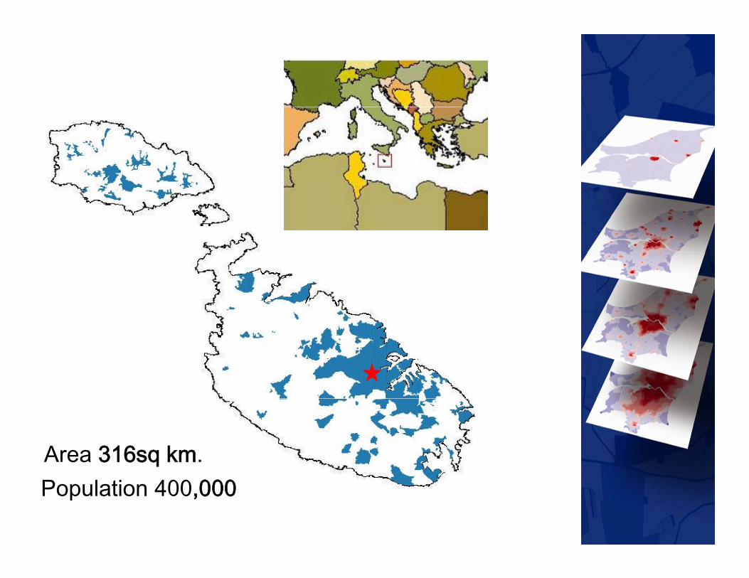
Area 316sq km.Population 400,000

GIS Lab University of MaltaGIS Lab, University of Malta
• GIS Laboratory linked to theGIS Laboratory linked to the Geography Division.
• Set up in 1996 through aSet up in 1996 through a donation from ESRI
• Started modules in GIS toStarted modules in GIS to Computer Science students, then moved on to teach GIS to Geography, Archaeology, Biology, Engineering, A hit t d Ed tiArchitecture and Education.

GIS Lab University of MaltaGIS Lab, University of Malta
• Results so far have beenResults so far have been encouraging.
• 2004, 20% of the geography , % g g p yprogramme graduates were directly employed in GIS in the fields of agriculture, transport and mineral resources management. GIS h i d h i ibili f• GIS has increased the visibility of Geography as a subject in the local job marketplacejob marketplace.

Introductory GIS modulesIntroductory GIS modules• Despite many disciplines embracing p y p g
spatial analysis, geography departments in higher education institutions still play a dominant roleinstitutions still play a dominant role in the teaching of GIS
• At undergraduate level GIS is aAt undergraduate level, GIS is a crucial subject/skill.
• Learning outcomes currently being discussed at European Level within the HERODOT Networkthe HERODOT Network.

Introductory GIS modulesIntroductory GIS modules
• Understanding your audienceUnderstanding your audience– Computer literacy
Spatial thinking skills– Spatial thinking skills– Background subjects
Issues of interdisciplinarity– Issues of interdisciplinarity
Introductory GIS modulesIntroductory GIS modules
• Main components of anMain components of an introductory GIS module
One semester duration– One semester duration– Theory and Practice
• definitions;• definitions; • history; • spatial data concepts, types, sources spa a da a co cep s, ypes, sou ces
and quality; • functionality, capture, structure,
i l ti l i d t tmanipulation, analysis and output; implementation, application

Introductory GIS modulesIntroductory GIS modules
• Coordination of information andCoordination of information and practical sessions– Hands on sessions (both fixed and (
independent study sessions)– Identification of a problem to solve– 70% of the assessment– Presentation in a report which
i l d i t d ti j tincludes introduction, project proposal, methodology, analysis, problems encountered and pconclusions and applicability of GIS

Introductory GIS modulesIntroductory GIS modules
• Advantages of the practicalAdvantages of the practical sessions and project
Improved spatial thinking– Improved spatial thinking– Better adaptability to problem
solvingsolving– Faster learning
Longer then expected use of GIS– Longer then expected use of GIS tools in future studies

Introductory GIS modulesIntroductory GIS modules
• Use of teaching aids for teachingUse of teaching aids for teaching GIS in Higher Education– GIS a young technology with lots of y g gy
its developments documented online– Books published online– Portals such as ESRI Virtual
Campus allows students to independently learn how to use GISindependently learn how to use GIS
– Self learning tools with books and software demos, most popular for , p pindependent studies (and exploration)
Teaching undergraduate GIS t i di i liGIS to various disciplines• GIS Lab a multidisciplinary centreGIS Lab a multidisciplinary centre• Each group taught separately to
ensure focus on subject areaensure focus on subject area (application)
• Instructor’s disposition to variousInstructor s disposition to various applications of GIS
• In professional degrees it helps toIn professional degrees it helps to research the industry expectations
• In many cases today there isIn many cases today there is supporting literature

Multi-disciplinary GISMulti disciplinary GIS
• Development of a GIS lab orDevelopment of a GIS lab or centre should focus on attractingvarious disciplinesvarious disciplines.
• A long term plan for the development of GIS training isdevelopment of GIS training is crucial to ensure both professional and courseprofessional and course development is constant.

Role of the studentRole of the student
• Student play a very important role.Student play a very important role.• Depends on student’s adaptability
to use computers and practiceto use computers and practice time dedicated during the semester.
• PBL defined as learning by doing.• Students are stimulated toStudents are stimulated to
formulate their learning goals and reflect on the quality of their q ylearning through a process, as well as the outcomes.
Role of the studentRole of the student
• Team work is critical in the GISTeam work is critical in the GIS projects.
• Problem solvers are organisedProblem solvers are organised and flexible, and are able to better apply knowledge for problem pp y g psolving.
• Student is therefore encouraged to gseek a spatial problem to investigate.
• Students vary when tackling GI Science rather then Systems

Role of the studentRole of the student
• Students today are generally keenStudents today are generally keen to use software / tools.
• It is however important for the• It is however important for the student to understand the processes that are going on in theprocesses that are going on in the tool.T d i f t d t t• Tendency is for students to go quickly through tutorials but never
d t d th d l iunderstand the underlying processes.

Role of the studentRole of the student
• This jeopardizes the future abilityThis jeopardizes the future ability to use and apply GIS successfully.
• Students are guided to understand• Students are guided to understand both how the tool works but also the analysis and processes theythe analysis and processes they are undergoing at each stage.O ti l it i it i d• Optional site visits are organised to major companies using GIS.
• Student is central to the learning of GIS.
ConclusionsConclusions
• Teaching has improved theTeaching has improved the development of undergraduate modulesmodules.
• Growing demand for geospatial skillsskills.
• University of Malta increasing its i t t (S S h l iinvestment (Summer School in July 2008)
• Future initiatives in this field to support the growing sector.


THE END