application process and standards guide - new york city · application process and standards guide...
TRANSCRIPT

TM
Changes to the City Map Version: 6.0
Contents
Changes to the City Map Application Process and Standards Guide
Version: 6.0
I. Applicability Of ULURP ..................................................................................................................... 2
II. Application Process .......................................................................................................................... 2
A. Pre-Certification Process ...................................................................................................... 2
B. Uniform Land Use Review Procedure .................................................................................. 4
C. Certification And Filing Of The Alteration Map .................................................................... 4
III. Application Requirements ............................................................................................................... 5
IV. Other Information ........................................................................................................................... 9
A. Costs: ................................................................................................................................... 9
B. Drainage Proposal ............................................................................................................ 12
C. The Fire Department ........................................................................................................ 12
D. Acquisition, Disposition And Waiver Of Interests In Property ......................................... 13
E. Mapped Parks .................................................................................................................... 15
F. Title Search ........................................................................................................................ 15
G. Builder's Paving Plan .......................................................................................................... 15
H. Public Safety ....................................................................................................................... 17
I. Miscellaneous .................................................................................................................... 18
J. Official Date ........................................................................................................................ 18
K. Time ................................................................................................................................... 18
V. Notice Procedure ........................................................................................................................... 20
Sample Notice……………………………………………………………………………………………………………………………….21
Form Response to Notice of Application………………………………………………………………………………………..22
Map Standards……………………………………………………………………………………………………………………………...23
January 2018 Version: 6.0
1
TM
Alterations of the City Map Version: 6.0
Applicability of ULURP Alterations or changes in the City Map are subject to Sections 197-c (Uniform Land Use Review Procedure), 198, and 199 of the New York City Charter and may be subject to Section 197-d (Council Review) as well. Applicants for a change to the City Map shall use the standard ULURP form in accordance with included instructions and submit all required documentation and the requisite number of copies along with requisite fee to Central Intake at the Department of City Planning (DCP). For further information on ULURP please visit the Department of City Planning’s website: http://www.nyc.gov/html/dcp/html/ap/index.shtml The City Map Change Process and Application Guidelines A. PRE-CERTIFICATION PROCESS FOR CITY MAP CHANGES
1. Optional Informational Interest Meeting Applicants seeking to better understand the application process or any of the requirements described in this document may contact the Department of City Planning’s Technical Review Division for an optional Informational Interest Meeting. This type of meeting will be especially helpful to new applicants. To schedule an Informational Interest Meeting, download the “Informational Interest Checklist” on DCP’s applicant portal, found here, and gather the required attachments. It is also advisable that applicants submit a current copy of the Borough President’s final section map for the project area, and a survey of the project site, if available.
To schedule an Informational Interest Meeting, please email the checklist and attachments to:
Phillip Montgomery, P.E. Chief Engineer / City Map Project Manager
Technical Review Division 212.720.3248
2. Pre-Application Statement
Prior to submission of a ULURP application, for any City Map Change that is not deemed to be “de minimus” (typically minor grade changes or ULURP approvals for already

January 2018 Version: 6.0
2
TM
constructed projects) by the Technical Review Division, applicants will be required to file a Pre-Application Statement with Central Intake at the Department of City Planning, via email, to [email protected] . Following the receipt of a completed PAS, the Department’s Lead Planner will reach out to the applicant/applicant representatives to schedule an Interdivisional Meeting with the team that will be responsible for reviewing the project at DCP.
3. Interdivisional Meeting
At the Interdivisional Meeting the applicant and any representative shall attend to discuss the proposed project with DCP staff from the Technical Review Division, and possibly the Borough Office responsible for the project area and the Environmental Review and Assessment Division (as needed). Applicants should be prepared to discuss the proposed project. DCP will discuss application requirements with the applicant at the meeting.
4. Draft Application
Applicants and their engineer or architect will be directed on the requirements for preparing their required application materials, beginning at the Interdivisional Meeting. This document, in section D. “Application Package Guidelines” contains additional information for applicants to use as they prepared their applications. The maps and ULURP application forms prepared by the applicant’s consultants will be reviewed by the mapping team staff and comments will be provided until all materials are suitable for filing. Before filing, the mapping team staff will request the applicant to submit a complete Draft ULURP application package for final review and a final sign off form will be issued. Applications will not be accepted at Central Intake without this signed form.
5. Filed Applications
ULURP applications for changes to the City Map upon submittal to DCP follow an inter-agency review process before achieving certification by the City Planning Commission.
1. Interagency Mapping Conference / Polling Letter In addition to the Notice of Receipt DCP staff sends out, required by law within a week from the date of receipt of the application, the Technical Review Division (TRD) project manager either sends out a polling letter to or schedules an interagency mapping conference with various City agencies and utilities to solicit technical comments on a proposal to change the City Map. The Interagency Mapping Conference is held approximately one month after an application is filed (allowing invitees adequate time to review the application). The conference is held at DCP headquarters and is chaired by the TRD mapping team project manager. Affected agencies and private utilities receive a copy of the application and have the opportunity to review and comment on the proposal either in writing or at the conference. The proposal is presented at the conference and attending agencies and utilities are invited to discuss questions, concerns or technical requirements. It allows for early identification of issues or requirements which need to be addressed and resolved and subsequently may

January 2018 Version: 6.0
3
TM
require the application to be modified.
2. Pre-Certification Report Approximately three weeks after the Interagency Mapping Conference is held or the polling letter is sent, TRD will issue a pre-certification report. The report includes a project and background description, a list of invitees and attendees of the interagency mapping conference, a brief discussion of the meeting, unresolved issues, and comments and requirements received from the City agencies and utilities. It also contains a formal request to the topographical bureau of the Office of the Borough President to review and sign an Alteration Map, prepared by his Office or by the applicant, for official transmittal to the Department of City Planning for processing.
3. Alteration Map Preparation
An Alteration Map, which will eventually become part of the official City Map, must be reviewed and signed by the Borough President and his consulting engineer, and transmitted to DCP before an application can be certified as complete by the City Planning Commission. This map is usually prepared by the Topographical Bureau of the Office of the Borough President or by the applicant's licensed engineer, architect, or land surveyor under the supervision of the Topographical Bureau and if so prepared must be signed and sealed by such licensed professional in addition to the BP required signatures. If any portion of a street proposed to be eliminated from the City Map is City-owned, a Discontinuance and Closing Map will be prepared along with the Alteration Map. Transmittal of the maps to DCP should include: calculations proving closure for new block geometries and tie in to existing street system; CAD files for the maps*; and discontinuance and closing metes and bounds descriptions. The application cannot be certified by the City Planning Commission into ULURP without these items. * The CAD file for the Alteration Map is also used by DCP to prepare a sketch map which ultimately is appended to the Notice of Certification and to the City Planning Commission report.
4. CEQR Sign Off Before certification into ULURP, the CEQR lead agency must:
1) Classify an action as a Type II action, which is not subject to CEQR and does not require further CEQR review, or, for Type I and unlisted actions,
2) Issue a negative declaration; or 3) Issue a conditional negative declaration; or 4) Issue a positive declaration followed by a Notice of Completion of a Draft Environmental Impact Statement (DEIS).
5. Proof of Notice to Adjacent/Underlying Property Owners After filing an application with the Department of City Planning, the applicant is required to notify adjoining and underlying property owners regarding their application. The applicant
January 2018 Version: 6.0
4
TM
must submit to the Department of City Planning proof of such notice prior to the certification of the application. Instructions for providing notice, a notice form, and notice response form can be found in the appendix.
B. ULURP CERTIFICATION
Certification is the process by which the City Planning Commission certifies that it has before it a complete application which is ready for land use review. Certification is legally authorized and defined in the ULURP Rules of Procedure, Section 3.015. The time periods set forth in sections 197-c and 197-d of the New York City Charter with respect to ULURP do not commence until an application has been certified as complete (certification begins the ULURP clock). Once all requirements of items A-C above are met, the TRD project manager will present the City Map change proposal to the City Planning Commission at a scheduled Commission Review Session to certify the application as complete. Once certified, the application follows the ULURP process which is described on the DCP website at: http://www.nyc.gov/html/dcp/html/ap/step5_ulurp.shtml PUBLIC NOTICE After the application is certified as complete by the City Planning Commission pursuant to section 3.015 of the ULURP Rules of Procedure, there will be public hearings at several stages during the process. 1) By the Community Board. 2) Possibly by the Borough President 3) Possibly by the Borough Board. 4) By the City Planning Commission. 5) Possibly by the City Council.
Public notice, in accordance with requirements specified in the ULURP Rules of Procedure, will be necessary for each public hearing.
C. CERTIFICATION AND FILING OF THE ALTERATION MAP Once a certified copy of the approved Alteration Map is certified and filed in accordance with section 198 subsection c of the New York City Charter (and if applicable Section 5-435 of the Administrative Code), that Alteration Map becomes part of the official City Map. Once the ULURP process is complete and the application for a change to the City Map is approved the Alteration Map is ready to be certified and filed pending any required “Mapping Agreement”. If the City Planning Commission report states that a “Mapping Agreement” is required, that particular Alteration Map will not be filed until the Chair of the City Planning Commission accepts said agreement when received from the Law Department. Once a Map is deemed ready to be certified and filed, the Technical Review Division of the Department of City Planning sends certification language to the Borough President’s Topographical Bureau and requests that it be added to the Alteration Map. The certification
January 2018 Version: 6.0
5
TM
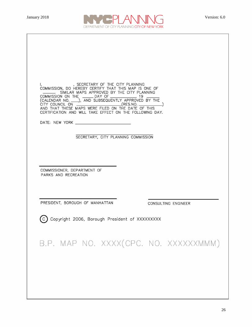
language contains the CPC approval date and calendar number and, if applicable, the City Council approval date and resolution number. The BP transmits a copy of the updated map to TRD for verification and when deemed satisfactory, the TRD requests the Borough President’s Office to submit the required number of copies of the Alteration Map for filing. The Secretary of the City Planning Commission certifies all copies and the Technical Review Division files the maps with the legally required City agencies. The certified and filed map becomes effective as part of the official City Map the day after filing.
D. APPLICATION PACKAGE GUIDELINES
The ULURP application package for the City Map change must include the following maps and documents. Please see the DCP Applicant Portal on DCP’s home page for links to forms, standards and sample documents.
a) Application Forms: Applicants should visit DCP’s website to download the appropriate land use form and supplemental forms.
1. Doing Business with the City Form 2. Land Use Application Form 3. Land Use Application Supplemental Form (MM) 4. Attachment 2: Site Data Sheet: This list should show all abutting and
underlying properties. It should include block and lot numbers, owner and most recent mailing address as shown in the records of the Department of Finance.
b) Project Description: The project description must describe any development proposal for the site, a detailed description of the proposed City Map change, and valid reasons for why such a change is necessary. It also must describe the current status of any street proposed for elimination from the City Map (width, improvements, traffic flow, ownership, etc). In addition, it should describe land use and zoning in the vicinity of the project area, including any landmarks and public facilities such as community centers, schools, churches, historic landmarks, etc.
c) Official Zoning Sectional Map: A copy of the current zoning map for the property available at http://www.nyc.gov/html/dcp/html/zone/zmf.shtml (Map Finder) or http://www.nyc.gov/html/dcp/html/zone/zonedex.shtml (Index Map). The zoning map must identify the location of the project site clearly.
d) Tax Map: Current tax maps, showing the project site property and all adjoining
properties as shown in the records of the Department of Finance. The tax map must identify the location of the project site clearly.
e) Topographical Survey: A topographical survey of all properties within and adjoining the
site of the proposed mapping action showing existing conditions, extending to the far sides of bounding streets. The survey should be an "order B" survey and must be prepared, signed and sealed by a licensed surveyor, architect, or engineer at the applicant's own cost and expense. The survey should:
January 2018 Version: 6.0
6
TM
1. Tie into the borough coordinate system; 2. Include detailed "record" line information as well as "adopted" line information; 3. Show the boundaries of existing wetlands, whether designated or not; 4. Show the boundaries of flood hazard areas; 5. Show contour information to two-foot intervals; 6. Show the location, size and direction of flow of utility lines; (Information regarding
sewers should cite field conditions and the adopted drainage plan reference number.)
7. Include the location of all federal, state and city survey monuments in place or, if missing, hidden, or shifted, include an appropriate note. [Locations can be determined from logs and indices in the BP’s' topographic bureaus, as well as from field inspection.]
8. Identify benchmarks; [Locations of monuments and benchmarks should be with respect to other monuments and (not with respect to street furniture).]
9. Identify all legal grades and existing grades within the area proposed to be changed. Grades should be shown at top of curb for the Bronx, Brooklyn, Staten Island and Manhattan. Grades should be shown at street center line for Queens.
NOTE: The surveyor or engineer will be required to prepare calculations and worksheets to the specifications of the Borough Presidents’ topographic bureaus.
f) City Map Change Area Map: Based on discussions at the pre-application meetings, the applicant shall carefully prepare an area map. The area map shall be a dimensioned land use map encompassing the entire effected project site and extending one block or for a radius of 600 feet beyond the site, whichever is greater (always show both sides of streets). The area map should contain the following elements: proposed changes to the City Map, street right-of-way lines, street treatment lines, street width dimensions, park lines, grades, traffic direction, ownership of street proposed to be changed, tax lot lines, block numbers, tax lot numbers, building footprints, number of stories and building use (R,M,C), zoning districts and zoning boundary lines, Pierhead and Bulkhead lines, easements, and a legend identifying elements of the map. The applicant’s property should be highlighted. Additional information may be required as per discussions at the pre-application meeting.
g) Application Map (Map of Proposed Change to the City Map): The map is a proposed map change drawing showing how the City Map will be changed and follows a format similar to that of an Alteration Map. This map will serve as a base for the Alteration Map.
The Map of the Proposed Change to the City Map is a fully dimensioned map showing proposed and existing street right-of-way lines, street treatment lines, dimensions and
January 2018 Version: 6.0
7
TM
angles (inside the block), street names, street widths, legal grades and tie-in distances, park lines and park line dimensions, Block numbers, monuments, Bulkhead and Pierhead lines, etc. Applicants are required to provide calculations when new blocks are created or existing block dimensions are changed. *Both the City Map Change Area Map and Application Map must: identify the applicant and the applicant’s address and contact information as shown on the application, show the title of the map, legend, drawing scales (both in Metric and English), north arrow (both borough north and true north), date prepared, and name of preparer. The applicants and their consultants are required to use the symbology as shown on the “Map Standards” sheet in the appendix. *The application and area maps should have following map elements:
Title: Sample format:
APPLICATION MAP SHOWING
THE ELIMINATION, (DISCONTINUANCE AND CLOSING)** OF
FIRST STREET BETWEEN
SECOND AND THIRD AVENUES
** A discontinuance and closing diagram or map is needed for any portion of a street proposed to be eliminated which is City-owned.
North Arrow: The maps should show both True North and Borough North. Please note
that Brooklyn and Staten Island use True North as Borough North. Scale: The drawing scale must be shown in both English and metric units and the map
must be true to scale. Legend: All line types and dimensions must be identified in the legend and must follow
those defined on the “Map Standards” sheet. Preparer: Application maps shall be sealed and signed by a registered architect or a
licensed professional engineer.
Date: The application map shall show the most current date. The following documents may be requested depending on the specific project:
a) Site Plan: A proposed site plan (if applicable) showing property lines, curb lines, curb cuts, parking, easements, and structures is required.

January 2018 Version: 6.0
8
TM
b) Project Area Photographs: Photographs may be requested to help DCP and other stakeholders understand the proposed project. Such photographs should show the Project Area, or area of the proposed City Map change. For example, if a street is to be eliminated, the photographs should show the street bed, street treatment (paving, curbs, curb returns and curb cuts) railroad tracks, columns, station stairs, trees, tree pits, vaults, topography conditions, encroachments and traffic signage, utility poles, catch basins, and manhole covers as well as building doors, windows and loading berths facing that street. Recent aerial photographs, if available are helpful.
c) Deeds: All deeds of the applicant's property within and around the street including
easement and right-of-way agreements in effect must be included in the application package.
d) Other Documents: Documents such as state alienation bill, title search affidavits etc
must be attached to support your application.
Other Information
1. WHERE TO OBTAIN FORMS AND INSTRUCTIONAL MATERIALS:
The ULURP form, the ULURP Rules of Procedure, the Rules of Procedure for City Environmental Quality Review, the CEQR Technical Manual, and the Environmental Assessment Statement form are all available from:
Map and Book Sales New York City Department of City Planning 120 Broadway, 31st Floor New York, New York 10271 212-720-3667 OR http://www.nyc.gov/planning
2. COSTS:
There may be substantial costs involved in applying for and effectuating a change in the City Map and potential applicants should be aware of some of them before commencing the proceedings. The costs noted below are not intended to be a complete listing of all costs. There may be additional costs from other involved government agencies. There also will be private costs, for example: architectural, legal, engineering, surveying, printing, distribution, and the cost of moving public and private utilities.
NOTE: Fee structures change continually and it is difficult to keep current. You are advised to

January 2018 Version: 6.0
9
TM
check on current fees. Neither the author nor the Department of City Planning takes any responsibility either for any errors contained herein or for any omissions.
A. FEES
1) Every application for a change in the City Map submitted to the Department of City Planning for processing shall include a non-returnable fee pursuant to Chapter 3 of Title 62 of the Rules of the City of New York.
For current fees visit: http://www.nyc.gov/html/dcp/html/ap/step4_filing.shtml As of April 1, 2011, the fee is: For the elimination of a paper street............... $ 1,740.00 For any other change in the City Map............ $ 5,445.00
Fees shall be made payable to the City of New York by check or money order.
Fees shall be paid when the application is filed and no application shall be processed by the Department until the fee is paid.
City, State and Federal agencies and certain not-for-profit entities may be able to claim exemption from this ULURP fee.
2) There is a nonreturnable fee for the filing of an application with CEQR. Calculation
of this fee may require the assistance of staff of the Environmental Review Division at (212) 720 - 3421.
a) PROJECTS MEASURABLE BY SQUARE FOOTAGE FEE Less than 10,000 sq. ft.................................. $ 460.00 10,000 - 19,999 sq. ft.................................... $ 1,350.00 20,000 - 39,999 sq. ft.................................... $ 2,940.00 40,000 - 59,999 sq. ft.................................... $ 5,465.00 60,000 - 79,999 sq. ft.................................... $8,195.00 80,000 - 99,999 sq. ft.................................... $ 13,660.00 100,000 - 149,999 sq. ft................................. $ 27,325.00 150,000 - 199,999 sq. ft................................. $ 47,815.00 200,000 - 299,000 sq. ft................................. $ 71,415.00 300,000 - 499,999 sq. ft................................. $ 128,545.00 500,000 - 1,000,000 sq. ft.............................. $ 192,820.00 over 1,000,000 sq. ft...................................... $ 314,225.00 b) PROJECTS NOT MEASURABLE BY SQUARE FOOTAGE (Ex: Bus franchises, Special Permit

January 2018 Version: 6.0
10
TM
Renewals that are subject to CEQR)……….. $ 1,880.00 Type II Actions …………………………….. $ 110.00
The fee shall be paid by a separate check or money order in the amount of the CEQR filing fee payable to the Department of City Planning. It should accompany the application.
No CEQR applications will be processed by either the Department of City Planning or the Department of Environmental Protection until the CEQR filing fee and twenty-five copies of the appropriate CEQR document have been filed with:
Central Intake Office Land Use Review Division New York City Department of City Planning 120 Broadway, 31st Floor New York, New York 10271 212-720-3366
ULURP applications also are to be filed with Central Intake. ULURP applications also will not be processed unless accompanied by the ULURP fee and the requisite number of copies of the ULURP application (usually twenty copies).
3) There is a fee for the preparation and review of each alteration map by the
topographical Bureau of the Office of the Borough President, even if the map is privately prepared.
If there is a street elimination map and a discontinuance and closing map for the same area the fee is separately payable for each map.
The fee at this time in most cases is $3000.00 per map, but there is some variation among the Borough Presidents. The individual borough presidents' topographical bureaus should be contacted in order to obtain their fee structures. Fee structures are being reviewed and fees are likely to rise within the coming year.
Once the map is prepared, the fee shall not be returned.

January 2018 Version: 6.0
11
TM
The topographical bureaus can be contacted at the following telephone and FAX numbers:
Borough Contact Telephone_________FAX Number Bronx C. Luo 718-590-8087 718-590-4690 Queens C. Viuker 718-286-2929 718-286-2927 Staten Island R. Englert, R.A. 718-816-2112 718-816-2060
Manhattan A. Gullota, P.E. 212-669-8138 212-669-7862 Brooklyn A. Goodman, P.E. 718-802-3816 718-802-3735
NOTE: The Bronx, Manhattan and Staten Island borough presidents’ topographical bureau do not prepare alteration maps changing the City Map. They only review alteration maps prepared by others.
4) In virtually all cases involving private applicants, the applicants will be required
to enter into an agreement (the mapping agreement) with the City, protecting the City's interest, approved as to form and sufficiency by the Corporation Counsel and duly accepted by the appropriate official or body. The map change will not be allowed to take effect until such final acceptance of the mapping agreement. There is a fee for review of the mapping agreement and related documents by the New York City Law Department, the office of the New York City Corporation Counsel. The fees are: For review of a mapping agreement........................ $1,500.00 For each bond that must be prepared in connection with a mapping agreement………………………. $400.00 For a deed.............................................................. $350.00 For a waiver of damages....................................... $200.00 For review of an insurance policy......................... $350.00 The fee shall be paid by the method and prior to the date specified by the New York City Law Department. For review of a mapping agreement protecting the city's interest and related items, contact:
Emily Keyes Senior Counsel New York City Law Department Tax and Bankruptcy Litigation Division 100 Church Street, Rm 5-245 New York, NY 10007 (212) 356-2160 phone

January 2018 Version: 6.0
12
TM
(212) 356-1148 fax [email protected]
NOTE:
Often it takes substantial time to prepare and complete a mapping agreement. Work on the agreement should take place SIMULTANEOUSLY WITH AND PARALLEL TO ULURP and CEQR processing. Therefore, it is advisable for the applicant to employ an attorney early in the process and to pursue detailed requirements of city agencies beginning immediately after the interagency conference. It is the obligation of the applicant’s attorney to: 1. Initiate negotiation of the terms of the mapping agreement with the New York
City Law Department, and 2. Draft the mapping agreement for review by the New York City Law Department.
5) There is a fee for filing proposed drainage plans with the Bureau of Waters and
Sewer Operation of the New York City Department of Environmental Protection (NYCDEP). The fee shall be paid by the method, in the amount and prior to the date specified by the DEP.
6) There is a fee for filing private builder's pavement plans with the New York City
Department of Buildings (eight dollars per lineal foot of public street frontage). The fee shall be paid by the method, in the amount and prior to the date specified by the Department of Buildings.
B. BONDS
Payment and performance bonds may be required of the applicant for work affecting City-owned utilities (eg.: water, sewer, street lighting). If these are required they shall be in amounts set by the affected agencies.
C. CONSTRUCTION AND RELOCATION COSTS
The applicant may be required to pay the costs of excavating, filling, grading and paving certain streets and sidewalks and of removing, cutting and capping, relocating and installing various utilities, including engineering and inspection costs as well as the cost of returning various fixtures to specified yards as may be required by the applicable utilities. The applicant will also have to secure all required permits for such work at its own cost and expense.
D. ACQUISITION COSTS
Applicants may have to acquire various interests in real property at their own cost and expense.
3. DRAINAGE PROPOSAL
In order to obtain comments from the NYCDEP, Bureau of Water and Sewer Operations, it is usually necessary first to file with the Bureau an amendment to the existing, proposed
January 2018 Version: 6.0
13
TM
and pending drainage plan which reflects the proposed change in the City Map. For additional information please visit DEP’s website at: http://www.nyc.gov/html/dep/html/forms_and_permits/index.shtml Guo Zhan Wu, P.E. Chief; Site Connection, Green Infrastructures and Plan Review Water & Sewer Planning Bureau of Water & Sewer Operations NYC Environmental Protection 59-17 Junction Boulevard 3rd Floor-Low Rise Flushing, NY 11373 718-595-5191 [email protected]
Often it takes substantial time for review and approval of the drainage proposal, therefore it is advisable for the applicant to employ an experienced consulting engineer early in the process and to commence work on the Drainage Plan immediately after (if not before) the interagency conference or issuing of the polling letter.
It may be necessary to revise legal grades in order to maintain proper drainage flow. Such revised grades will appear as changes on the alteration map.
4. THE FIRE DEPARTMENT
In order to obtain comments from the Fire Department, it is usually necessary to include on the City Planning application drawings, dimensions and specifications sufficient to show how the Fire Department can enter, fight fires, turn fire department vehicles around and exit. Furthermore, it is usually necessary to provide water service, hydrant and alarm box location plans for any proposed development. Additionally, applicants will have to comply with the Department's Fire Prevention Directives as amended to date.
A free brochure entitled Requirements for Private Street Systems can be acquired from:
Robert Sweeney
Chief of Operations New York City Fire Department 9 MetroTech Center Brooklyn, New York 11201 - 3857 Telephone: (718) 855-8571 FAX: (718) 522-6771
Att: Paul Geoghegan

January 2018 Version: 6.0
14
TM
City Planning Desk
5. ACQUISITION, DISPOSITION AND WAIVER OF INTERESTS IN PROPERTY
A. PRICE = FAIR MARKET VALUE Applicants may have to acquire City-owned land in the bed of a discontinued and closed street or park. Pursuant to Section 4-105 of the New York City Administrative Code, such acquisition will be at an appraised fair market value, determined by an appraisal made within six months of closing of the sale. The appraisal will be provided by the New York City Department of Citywide Administrative Services Division of Real Estate Services upon the request of the New York City Law Department. The various costs of preparing an application for a change in the City Map, processing such application and complying with agency requirements will not be subtracted from the appraised fair market value.
FOR EXAMPLE:
If a discontinued and closed street is 60 feet wide and 500 feet long and the appraised fair market value of comparable vacant land in that area is $10.00 per square foot, then the fair market value of the land being conveyed in the former street bed = 60 X 500 X $10.00 = $300,000.
To learn more about the process, contact:
Randal Fong First Assistant Commissioner Division of Real Estate Services NYC Department of Citywide Administrative Services 19 North One Centre Street New York, N.Y. 10007 Telephone: (212) - 669 - 7150 FAX: (212) - 669 - 8972
E-mail: [email protected]
B. ALIENATION REQUIRING DISCONTINUANCE AND CLOSING Where there is a city interest in the bed of a street, there may also have to be a discontinuance and closing of the street pursuant to Section 5-430 et seq. of the New York City Administrative Code. Pursuant to Section 383 of the City Charter, the City cannot sell land in the bed of a street in which the city holds an interest for street purposes, even if the street has been eliminated from the City Map, unless the street first is discontinued and closed.
January 2018 Version: 6.0
15
TM
C. EASEMENTS Applicants may have to give easements for access or passage and for utilities to remain. Applicants may have to acquire certain utility lines from the City. The price of such acquisition may be based on the unamortized value of the portion of the utility line being acquired. Applicants may be required to cut and cap or relocate utility lines at their own cost and expense, including the cost of City supervision and inspection, or pay to have the City perform the work. Applicants may have to install valves or meters or other equipment at their own cost and expense. Applicants may physically have to remove specified fixtures from the street and return them, in good condition, to specified utility maintenance and supply yards. Applicants may be required to waive damages for loss of access to a street or to water or change of grade; may have to obtain similar waivers from adjoining property owners; and may have to hold the City harmless from potential damages to adjoining property owners by reason of the map change.
D. CESSION OF APPLICANTS' LAND TO THE CITY
Applicants may be required to cede land or interests therein to the city for street, park or other public purposes. Applicants may be required to acquire and cede to the city privately-owned land in the bed of streets affected by the alteration map. Such acquisition may be effectuated by the applicant, either privately by negotiating with the existing property owners or by requesting that the city condemn the property and then reimbursing the city for condemnation costs.
E. CONTRACT OF SALE
The mapping agreement acts as a contract of sale and as a vehicle for other legal agreements between the applicant and the City of New York. The timetable for the preparation and review of the mapping agreement is contained on pages 24 and 25 below, within the sample chronology.
6. MAPPED PARKS
Mapped parks cannot be "demapped" without first obtaining special State legislation. Such legislation should be sought only by the Department of Parks and Recreation. Applications regarding parks should utilize the Standard Details published by the Department of Parks and Recreation, as well as the standards contained herein or appended hereto. The elimination of a park from the City Map may require the replacement in kind of land for parks in the general area of the map change.
To obtain the Standard Details or to request the Department of Parks and Recreation to initiate the process of obtaining State legislation, contact:
Alyssa Cobb Konon Assistant Commissioner, Planning & Parklands NYC Department of Parks and Recreation The Arsenal Building, Room 401
January 2018 Version: 6.0
16
TM
830 Fifth Avenue New York, N.Y. 10021 Telephone: (212)-360-3411 FAX: (212)-360-8293
7. TITLE SEARCH Applicants may be required to carry out, at their own cost and expense, a complete and thorough title search of the street in question, perhaps going back several centuries. The purpose of the title search is to determine the ownership of various interests in the street in question. This may require an examination of, among other things:
A. Conveyances B. Subdivision maps C. Old surveys D. Records of government actions E. Extent of various ownerships F. Corporation Counsel Opinions of Dedication
8. BUILDER'S PAVING PLAN In order to proceed, after an alteration map is drawn and before any permit for physical work in the street can be issued, the applicant will have to file a private builders paving plan with the New York City Department of Buildings in the involved borough, in accordance with that department's Procedural Guidelines as well as Section 2-16 of Title 34 of the Rules of the City of New York.
In order to assist an applicant in preparing a Builder's Pavement Plan the Department of Buildings has prepared a brochure entitled "Filing a Builder's Pavement Plan - How to Proceed." The brochure is available at the borough offices of that department.
In connection with the paving plan, the applicant may have to prepare street profiles and typical sections.
Applicants will have to construct mapped streets which are not yet built, but on which the property fronts, in accordance with Section 36 of the New York State General City law, and NYCDOT standards, usually for one half of the street's mapped width plus five feet.
The applicant may be required to grade, pave, remove or install curbing and curb returns, provide drainage facilities and install beam barriers, and perform other necessary work in accordance with standards set and enforced by DOT. These include Standard Details of Construction, Standard Specifications of the Department and the NYCDOT Rules and Regulations. Additionally, the applicant may be required to install ramps for the handicapped between the sidewalk and the roadway pursuant to federal, state and city law.
In connection with such work the applicant will have to secure all required permits at its own cost and expense.

January 2018 Version: 6.0
17
TM
In performing street work, the applicant will take care to preserve existing city and federal survey monuments in their correct locations and may be required to install new or replacement survey monuments as the Topographical Bureau of the Borough President may direct. Field notes and work sheets from the field survey shall be transmitted to the Topographical Bureau for retention. If there is an excavation, embankment, or laying or moving of any pavement or flagging within three feet of any survey monument, the applicant shall apply, pursuant to section 3-508 of the New York City Administrative Code, to the Topographical Bureau for a permit. The applicant may be liable for the cost and expense incurred by the Borough President's office for engineering, surveying and inspection work pursuant to section 3-509 of the Administrative Code.
Completion of the work detailed in a pavement plan will be included as an element of the mapping agreement. Therefore, it is advisable for the applicant to employ an engineer early in the process and to have the pavement plan prepared for initial review beginning immediately after the interagency conference.
In connection with such work, the applicant may have to obtain franchises or revocable consents for use of city streets (possibly requiring separate review under ULURP); may have to obtain or grant easements; may have to obtain waivers from affected owners; and may have to post bonds. Prior to the applicant's proposed physical closing of any street or portion thereof, the applicant shall give thirty (30) days written notice to:
Office of Construction Mitigation and Coordination NYC Department of Transportation 55 Water Street New York, NY 10041 ATTENTION: Edward Campbell Director, OC-MC-Highways Telephone: (212) 839-9643 Fax: (212) 839-8970
Prior to the start of Construction, the applicant must give thirty (30) days written notice to the Department of Transportation Bureau of Bridges and Highways to arrange for adequate inspection. The address is:
Udaya Kumar Dommaraju, PE
Director -Engineering Review NYCDOT - Division of Bridges 55 Water Street New York, NY 10041 Ph: (212) 839-4029

January 2018 Version: 6.0
18
TM
FAX: (212) 839-4924 [email protected]
Prior to the start of construction, the applicant must comply with Part 53 of Title 12 of the Official Compilation of Codes, Rules and Regulations of the State of New York (12 NYCRR 53), also known as Industrial Code Rule 53. An applicant must commence compliance by calling the New York City One Call Center at 1-800-272-4480, at least two working days before the applicant plans to commence digging.
9. PUBLIC SAFETY
The applicant may be required to prepare a traffic accident analysis of certain streets or intersections. Such analysis should indicate, historically, the volume of collisions, their location, time of day, traffic conditions or other conditions contributing to the collisions, as well as scenarios of repeated types of collisions. The analysis should include proposals to mitigate hazards and the potential for collisions after modification of the City Map. Data may be available from the traffic safety officer of the local police precinct or the New York State Department of Motor Vehicles.
10. MISCELLANEOUS
In order to obtain detailed requirements necessary for a mapping agreement, from the bureau of water supply and Waste Water Collection, it will be necessary to contact:
Guo Zhan Wu, P.E. Chief; Site Connection, Green Infrastructures and Plan Review Water & Sewer Planning Bureau of Water & Sewer Operations NYC Environmental Protection 59-17 Junction Boulevard 3rd Floor-Low Rise Flushing, NY 11373 718-595-5191 [email protected]
In order to obtain from the bureau of traffic, detailed requirements with respect to street lighting, necessary for a mapping agreement, it will be necessary to contact:
Ghanshyan Patel, PE, Director Division of Street Lighting New York City Department of Transportation 34-02 Queens Boulevard Long Island City, New York 11101 Telephone: 718-786-4595 FAX: 718-472-9312
January 2018 Version: 6.0
19
TM
11. OFFICIAL DATE Maps do not take effect until they are duly adopted pursuant to ULURP and thereafter certified by the Secretary of the City Planning Commission and filed in accordance with Section 198 subsection c of the New York City Charter and, if there is a discontinuance and closing, pursuant to Section 5-435 of the New York City Administrative Code. (Such certification is not the same as certification of completeness under Section 3.015 of the ULURP rules.) Such certification and filing takes place only after approval by the appropriate official or body of a report from the Office of Management and Budget (if applicable) and a signed mapping agreement.
12. TIME
The time to effectuate a change in the City Map can be lengthy. Potential applicants should be aware of the amount of time before they commence the proceedings. Please note that it is reasonable and possible to complete the process in a significantly shorter time if: 1. An applicant's engineering consultant prepares the alteration map and application drawing simultaneously by computer, so that the waiting period for completion of an alteration map is substantially reduced; and 2. An applicant pursues requirement letters from necessary agencies SIMULTANEOUSLY WITH AND PARALLEL TO ULURP and CEQR rather than waiting until after the completion of ULURP to seek such letters.
NOTICE PROCEDURE 1. The applicant for a change in the City Map must simultaneously send to each of the owners
of abutting and underlying property: a. A properly filled out Notice of Application in accordance with attached form, and b. A properly filled out Form Response to Notice of Application.
2. Before sending the Notice of Application to those owners, the applicant must fill out the
Notice of Application completely, including the addresses and telephone numbers of the correct Community Board, Borough President, Borough office of the Department of City Planning and applicant’s contact person.
3. Before sending the Form Response to those owners, the applicant also must fill out, on the
Form Response, for each addressee, the addressee’s name and address, their block, lot and borough, the ULURP number, if known, and, in the reference, a skeletal description of the project.
4. If the addressee/owner decides to respond, the addressee/owner must fill out, on the
Form Response, the date of the response, a check off of the appropriate response, any reasons for opposition and their signature.
5. The applicant must send to those owners, with a Form Response, a stamped envelope
addressed to:

January 2018 Version: 6.0
20
TM
Project Manager for Mapping Technical Review Division New York City Department of City Planning 120 Broadway, 31st Floor New York, NY 10271 6. The applicant must include in its application: a. Copies of the Notice of Application as sent.
b. A list of all of the addresses to whom the Notice of Application Form was sent, with the block and lot numbers of the properties that they own.
c. A United States Postal Service Proof of Mailing. d. Return receipts of certified mailing. e. All notices returned to sender, undelivered.
f. Copies of all responses sent directly to the applicant, including those opposing the proposal.
7. The New York City Department of Parks and Recreation (and other City Agencies) must also
conform with the New York State Eminent Domain Procedure Law with respect to Notice.

January 2018 Version: 6.0
21
TM
SAMPLE NOTICE TO ABUTTING OR UNDERLYING PROPERTY OWNERS
APPLICANT LETTERHEAD CERTIFIED MAIL RETURN RECEIPT REQUESTED Date: (Addressee)
NOTICE OF APPLICATION
Re: ULURP No. Project: Dear , The (Applicant) , according to the procedures of the Department of City Planning, is required to notify you, as an abutting (or underlying) property owner, on Block Lot that we have submitted an application for a change in the City Map. The location of the map change is as follows: Plans for this proposal (are/once submitted, will be) available for inspection, by appointment only, Monday to Friday from 9:00 AM to 5:00 PM at the following locations: 1. Community Board # 2. The Office of the Borough President - Land Use Review Telephone: Telephone: 3. The Department of City 4. The Department of City Planning Planning - Borough Office Technical Review Division, 31st Floor 120 Broadway New York, NY 10271 Telephone: Telephone: The Department of City Planning requests that you, as an abutting (or underlying) property owner, submit a letter to the Department stating whether you favor, oppose, or have no opinion about this proposal. Should you have any further questions regarding this matter, please contact: at
Sincerely,

January 2018 Version: 6.0
22
TM
FORM RESPONSE TO NOTICE OF APPLICATION
DATE: (ADDRESSEE OF NOTICE OF APPLICATION)
Owner of: BLOCK LOT
BOROUGH:
TO: TEAM LEADER FOR MAPPING TECHNICAL REVIEW DIVISION, 31st Floor NYC DEPARTMENT OF CITY PLANNING 120 BROADWAY NEW YORK, NY 10271
ULURP NO.
PROJECT:
Dear Sir,
The undersigned acknowledges receipt of a Notice of Application for the referenced
proposal.
The undersigned favors the proposal.
The undersigned does not now possess sufficient information in order to form an
opinion about the proposal.
The undersigned has no comment at this time.
The undersigned opposes the proposal for the following reason(s):
(attach additional pages if necessary)
Signature of addressee of Notice of Application

January 2018 Version: 6.0
23
TM
MAP STANDARDS shown below are Not to Exact Scale. An exact scale PDF may be requested. • Plotted text heights are: L80= 0.08”, L100= 0.10”, L120= 0.12”, L140= 0.14”. • Can use Leroy font style or Arial. • Numbers with millimeters (mm) indicate pen weights.

January 2018 Version: 6.0
24
TM

January 2018 Version: 6.0
25
TM
January 2018 Version: 6.0
26
TM

April 1st, 2017 Version: 6.0
1
TM