application of proposed boundary adjustment for nahatlatch ... · application of proposed boundary...
TRANSCRIPT
September 23, 2013
1 | P a g e
Application of Proposed Boundary Adjustment for Nahatlatch Provincial Park
Stage 1: Initial Proposal
1. Applicant/Proponent Information and Contact Details
Ministry of Transportation and Infrastructure PO Box 9850 Stn Prov Govt Victoria, BC V8W 9T5 Attention: Garth Stewart, Senior Manager, Aboriginal Relations
2. Proposal for Park Boundary Adjustment
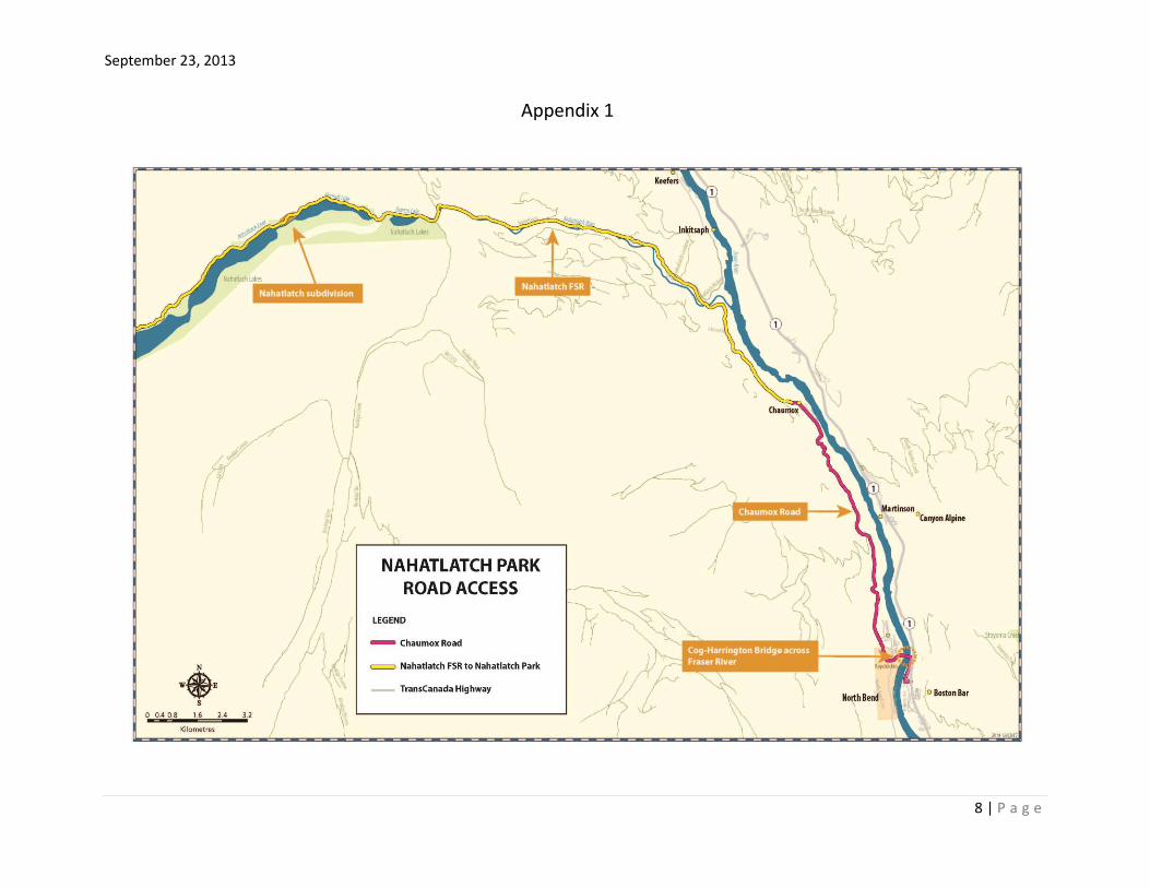
Ministry of Transportation and Infrastructure (“MOTI”) is seeking support from BC Parks to complete a Park Boundary Adjustment to Nahatlatch Provincial Park (the “Park”). MOTI’s application to remove two small discrete tracts of park land is for the purpose of offering that land to Boston Bar First Nation (“BBFN”) as part of a negotiated agreement for the Province’s acquisition of Indian reserve land at North Bend. A successful outcome to the negotiations will resolve a trespass on Kopchitchin Indian Reserve No. 2 (the “Reserve”), and thereby provide certainty of road access to the Park. Appendix 1 illustrates the Nahatlatch Park Road Access between North Bend and the Park. 3. Location of Area Proposed for Boundary Adjustment
Deletion Area
MOTI is proposing to remove approximately 1.5ha from the Park, comprised of two unsurveyed tracts of park land, described as areas of interest (the “AOIs”). The AOIs are either contiguous or close to the Nahatlatch Lake subdivision, located between Nahatlatch Lake and Hannah Lake. Appendix 2 shows the location of the AOIs proposed for deletion from the Park. The eastern AOI is a thin wedge of land of approximately 1.0 ha. in area, located between the Nahatlatch Forest Service Road (the “FSR”) and Hannah Lake. The water frontage of this AOI is approximately 480m, and the foreshore consists of extensive reeds. There is no indication this AOI is used for water access.

September 23, 2013
2 | P a g e
The western AOI is a wooded area consisting of approximately 0.36ha of land, with approximately 70m of water frontage.
Addition Area
MOTI is proposing the addition of a tract of unsurveyed Crown land to the Park. The proposed tract is adjacent to the western boundary of Lot 1846 in the subdivision and, north of the FSR (Appendix 2). 4. Project footprint (inside and outside the protected area) including all project
components such as access routes.
Project – Certainty of Road Access to Nahatlatch Park The Cog Harrington Bridge (the “Bridge”) spans the Fraser River between Boston Bar and North Bend, on the east side and west side of the Fraser River respectively. The west footings of the Bridge and a portion of Chaumox Road – the western approach to the Bridge – are within the Reserve. This area is shown in Appendix 3. The Bridge provides the only access across the Fraser River in this section of the Fraser Canyon. The Bridge is used by a number of industrial, commercial, residential, and recreational users. There is no alternate route to the Park. In the Fall of 2007, BBFN’s legal counsel issued notices of trespass to a number of commercial and industrial users of the Bridge, including: Canadian Pacific Railway; Canadian National Railway; Fraser Valley Regional District (“FVRD”); the FVRD waste management contractor, Smithrite; and a MOTI contractor replacing the bridge on Chaumox Road, north of North Bend. The notices of trespass instructed commercial and industrial users to make arrangements with BBFN to pay a road use fee ($200 each way), or stop using the bridge. In response to the notices of trespass, MOTI staff sought and received a commitment from BBFN that as long as MOTI and BBFN were negotiating in good faith towards a resolution of the trespass, BBFN would stop sending notice of trespass. Since 2008, ministry staff have been negotiating with BBFN’s chief and council on a “without prejudice” basis. 5. Preliminary description of economic, social, and environmental impacts and
benefits of the project
Economic Impacts and Benefits
Formalizes road access to Nahatlatch Park;
Eliminates the possibility of BBFN’s imposition of road use fees;
Provides certainty for all bridge users – commercial, industrial, recreational;

September 23, 2013
3 | P a g e
The estimated cost of building a new bridge is in the range of $20M - $25M. A
new bridge would likely require land from the Reserve, and would certainly
require extensive consultation with First Nations, including BBFN;
Social Impacts and Benefits
Facilitates negotiations towards reaching a Memorandum of Agreement (the
“MOA”) between the Province and BBFN for the resolution of the tenure issue in
the Reserve;
Eliminates the possibility of bridge closure by BBFN;
Provides certainty for all bridge users – commercial, industrial, recreational;
Demonstrates the Province’s willingness to reach agreement with BBFN; and
Addresses BBFN’s objections in 1999 to the sale of the Crown land in the
subdivision.
Environmental Impacts and Benefits
Minimal reduction in area of Nahatlatch Provincial Park (the whole park contains
approximately 2000ha);
Potential reduction of park use at the eastern end of Nahatlatch Lake, depending
on location of a designated camping area in this vicinity;
Minimal impact on recreational attributes of the parcels as there appears to be no recreational facilities in, and little recreational use of the AOIs.
6. Preliminary assessment of alternatives that would avoid the use of protected
lands and the reasons those alternatives are not considered feasible.
Identification of Replacement Land Areas of Interest MOTI has been in negotiations with BBFN since 2008 to identify a suitable land package. During that time, BBFN has consistently focussed on acquiring land in the Nahatlatch Lake subdivision (the “Subdivision”). The Subdivision is made up four district lots; two fronting on Hannah Lake, and two on the upland side of the FSR (Appendix 4). Each of the four district lots were surveyed into recreational lease lots. All but one of the waterfront lease lots has been Crown granted, and is now held in fee simple. Two subdivision roads provide legal access from the FSR to Hannah Lake. Both roads are overgrown, cannot easily be identified on the ground, and are passable by footpath only, if at all. BBFN asserts a claim to aboriginal rights, including aboriginal title, over the Nahatlatch Lake and River area. In 1999, BBFN objected to the Province’s proposed sale of Crown lease lots within the Subdivision. However, the Province sold the Crown land over BBFN’s objections, and BBFN continues to raise that sale as an outstanding issue in its relationship with the Province.
September 23, 2013
4 | P a g e
Federal Process
Indian reserve land in Canada is held by the Federal Crown for the use and benefit of the respective Indian Band, or First Nation. Canada administers BBFN’s reserve land under the provisions of the federal Indian Act. Consequently, only Canada can convey an interest in BBFN’s reserve land to the Province for transportation purposes. When concluding and executing a negotiated agreement with a First Nation for the Province’s acquisition of Indian reserve land for transportation purposes, MOTI recognizes that in order to persuade the First Nation to accept a transfer of Canada’s entire interest to the Province for transportation purposes, MOTI would need to put before the First Nation’s council an attractive package of benefits to ensure that the transaction would, when considered as a whole, provide a net benefit to the First Nation. The package of benefits would also have to meet the requirements of Canada. Some of the components that MOTI may consider are:
1. Addition to Reserve (ATR) Land - a parcel or parcels of land that would be acceptable to the First Nation and that would meet Canada’s ATR Policy.
2. Other Land – Depending on the size and value of the parcel to be added to the First Nation reserves, and any cash component that might form part of the transaction (see #3 below), MOTI would be prepared to look at providing land that would not necessarily be added to the First Nation’s reserves, as part of the transaction.
3. Cash – MOTI may make a cash payment as part of the benefits to be delivered to the First Nation, to ensure that the transaction is of net benefit to the First Nation.
4. Compensation for past use – MOTI would consider paying reasonable compensation for past use, where appropriate.
5. Reimbursement of costs – MOTI would be prepared to provide a reasonable amount towards the First Nation’s anticipated professional and administrative costs in negotiating and concluding an agreement.
6. Revenue from Utilities – MOTI would make acceptable arrangements to ensure that the First Nation would not suffer any loss of tax revenue as a result of a transfer to the Province of Canada’s entire interest in the subject reserve land. The necessary provisions would be discussed and clarified during our negotiations.
7. Construction of Access – MOTI would consider authorizing and/or building access from existing or proposed developments on the First Nation’s reserve land to, subject to meeting MOTI’s Standard Specifications and permitting requirements.
One key requirement is Canada’s policy of no net loss of reserve land. This policy means that Canada will almost certainly require that the Province provide land for addition to BBFN’s reserve land that’s at least equal in area and value to the land to be removed from BBFN’s reserve.
September 23, 2013
5 | P a g e
The federal process generally takes a minimum of two years, from the date that MOTI and the First Nation execute their negotiated agreement until the federal transfer of the subject reserve land to the Province. 7. First Nations and local governments potentially affected by the project, and
status of any discussions with these governments (Consultation).
First Nations
A number of First Nations’ territories overlap the AOIs. In addition to BBFN, the following is a list of the other First Nations and aggregate groups, as identified in the Consultative Area Database:
Siska Indian Band
Cook’s Ferry Indian Band
Lower Nicola Indian Band
Lytton First Nation
Nlaka'pamux Nation Tribal Council
Nicola Tribal Association
Oregon Jack Creek Band
Spuzzum First Nation
Nooaitch Indian Band
Coldwater Indian Band BBFN is a member of Nlaka’pamux Nation. Boothroyd Indian Band’s traditional territory extends almost as far as the Park; however, it does not overlap the Park or the AOIs. Nonetheless, Boothroyd Indian Band currently holds the contract for maintenance of the Park. Local Governments The AOIs are located within the Fraser Valley Regional District. Ministry of Forests, Lands and Natural Resource Operations (MFLNRO) MOTI has had several discussions with MFLNRO, in meetings and correspondence, regarding the negotiations with BBFN. MFLNRO understands the lack of legal road access to the Nahatlatch Lakes area, and is supportive of resolving that issue. 8. Known community groups with an interest in the protected area and the status
of any discussions with these groups.
The Park is used for fishing, boating, camping and swimming. It is quite remote and undeveloped. Parks users may raise concerns about the AOIs being transferred out of the Park. However, it is difficult to anticipate the real impact to any use of the Park

September 23, 2013
6 | P a g e
without completing investigations into existing uses of the AOIs. MOTI has not undertaken discussions with known community groups regarding the protected area. Lease holders and property owners within the Subdivision may raise concerns about the AOIs being transferred out of the Park. MOTI has not undertaken any discussions with any of these interest holders regarding the protected area. 9. Any known environmental issues (e.g. species at risk impacts, fish habitat).
Overview According to the BC Conservation Data Center, there is no record of information on species at risk in the Nahatlatch area. The below information on wildlife and fisheries was taken from a draft, unreferenced report which included data from the early 1990’s. Wildlife The Nahatlatch watershed is known to support low to moderate populations of mule deer, black bear, grizzly bear, cougar, mountain goat, and other furbearing animals. Rocky mountain elk have also been reported in the watershed. The valley is situated in a transition zone between the wetter Coastal Western Hemlock and the drier Interior Douglas-fir biogeoclimatic zone, and therefore has the potential to support a diversity of species. Fisheries The Nahatlatch River contains many anadromous fish species, including, Chinook salmon, coho, sockeye, and pink salmon. Wild winter run steelhead also inhabit the Nahatlatch system, although their distribution is thought to extend upstream only to Frances Lake. When inventoried in 1973 by Fish and Wildlife Branch, fish species found included rainbow trout, Dolly Varden char, Rocky Mountain whitefish, peamouth chub, coarse scale sucker and prickly sculpin. Archeological/cultural impacts Nahatlatch Lake, Hannah Lake, and Nahatlatch River are all in BBFN’s traditional territory. According to the First Nation, their ancestors fished and traveled on the waters, harvested berries, mushrooms, and plants for food, medicinal, and spiritual purposes. They also harvested trees, and hunted and trapped animals. Sacred sites dot the territory around the park as well. Land and water-based travel routes and seasonal campsites were in regular use across the territory. Currently, BBFN members continue to use the Nahatlatch Lakes area to hunt fish and gather on a regular basis. 10. Anticipated project schedule/timeline
MOTI has been negotiating with BBFN since 2008 to formalize road access to the Park. If the Park Boundary Adjustment is approved, MOTI is confident that it can conclude and execute an agreement with BBFN shortly after the adjustment is complete.

September 23, 2013
7 | P a g e
11. Maps and illustrations as appropriate
Please see attached appendix.
September 23, 2013
8 | P a g e
Appendix 1 Appendix 1

September 23, 2013
9 | P a g e
Appendix 2

September 23, 2013
10 | P a g e
Appendix 3

September 23, 2013
11 | P a g e
Appendix 4

September 23, 2013
12 | P a g e
Appendix 5