appendix p waterbodies and wetlands - state river watershed (mp 774.7 - mp 790.1) s-775a 775.5...
TRANSCRIPT

APPENDIX P
Waterbodies and Wetlands
FEIS Alberta Clipper Project

This page left intentionally blank.
FEIS Alberta Clipper Project

APPENDIX P1
Waterbodies Crossed by Proposed Alberta Clipper and the Southern Lights Diluent Pipeline Projects
FEIS Alberta Clipper Project

This page left intentionally blank.
FEIS Alberta Clipper Project

FEIS Alberta Clipper Project P1-1
TABLE P-1 Waterbodies Crossed by Proposed Alberta Clipper and the Southern Lights Diluent Pipeline projects
Uni
que
ID
MP
Nam
ea
Cou
nty
Flow
b
Top-
of-B
ank
Wid
th
(ft)
Uni
que
Feat
ures
Com
men
ts
(adj
acen
t cul
vert
s,
wet
land
s, e
tc.)c
MN
Pro
tect
. Wat
er/
WI A
reas
of S
peci
al
Nat
ural
Res
ourc
e In
tere
std
MN
Pro
tect
. Wat
er
ID N
umbe
r
303(
d) L
istin
ge
Wat
er
Cla
ssifi
catio
nf
Reg
ulat
ed
Fish
erie
s
Alb
erta
Clip
per S
ite
Spec
ific
Dra
win
g R
equi
red?
Dilu
ent S
ite
Spec
ific
Dra
win
g R
equi
red?
Dep
th o
f tre
nch
(ft)g
Alb
erta
Clip
per
Prop
osed
Cro
ssin
g M
etho
dh A
lber
ta C
lippe
r A
ltern
ativ
e C
ross
ing
Met
hodh
Dilu
ent P
ropo
sed
Cro
ssin
g M
etho
dh
Dilu
ent A
ltern
ativ
e C
ross
ing
Met
hodh
Brid
ge P
ropo
sed?
h
Tem
p EW
S
NORTH DAKOTA Pembina River Watershed (MP 774.7 - MP 790.1) s-775a 775.5 Pembina
River i, j, m Pembina P 100 • Erosion
• Steep side slopes
• None N/A N/A • Cadmium • Copper • Lead • Selenium • Sedimentation / Siltation • Benthic/Fishes Bioassessments • Fecal Coliform
I Class III Fishery "Substantial Fishery Resource" HDD or no in-channel work from April 15 - June 1
Yes N/A N/A HDD DC N/A N/A None Typical
s-778a 778.7 Ditch #42 Pembina I 50 • None • Reed Canary Grass • Agricultural
N/A N/A No III No N/A 17 OC N/A N/A Mat Typical
s-781b 781.2 Drain #8 Pembina I 50 • Steep side slopes
• Reed Canary Grass • Agricultural
N/A N/A No III No N/A 15 OC N/A N/A FSMS Typical
s-781a 781.2 Drain #8 Pembina I 30 • None • Agricultural N/A N/A No III No N/A 15 OC N/A N/A FSMS Typical s-781c 781.4 Auger Coulee Pembina I 50 • None • Reed Canary
Grass • Agricultural
N/A N/A No III No N/A 29 OC N/A N/A FSMS Typical
s-782a 782.6 Tributary to Tongue River / County Drain #33
Pembina S 30 • None • Adjacent wetland (w-782b) • Reed Canary Grass • Agricultural
N/A N/A No III No N/A 13 OC N/A N/A FSMS Typical
s-783a 783.3 Tongue River “cutoff”
Pembina P 100 • Steep side slopes
• Adjacent wetland (w-783a) • Reed Canary Grass • Agricultural
N/A N/A • Sedimentation / Siltation • Benthic/Fishes Bioassessments
II No N/A 41 OC N/A N/A FSMS Typical
s-786a 786.1 Tongue Rivers Pembina P 50 • Steep side slopes
• Iced over at time of survey
N/A N/A No II Class III Fishery "Substantial Fishery Resource" HDD or no in-channel work from April 15 - June 1
No N/A 25 HDD OC N/A N/A None Typical
s-788a 788.7 Unnamed Ditch
Pembina I 20 • None • Reed Canary Grass • Agricultural
N/A N/A No III No N/A 13 OC N/A N/A Mat Typical
s-790b 789.9 Ditch to Loughton WMA
Pembina I 20 • None • Adjacent to wildlife management area
N/A N/A No III No N/A 11 OC N/A N/A FSMS Typical

FEIS Alberta Clipper Project P1-2
TABLE P-1 (continued)
Waterbodies Crossed by Proposed Alberta Clipper and the Southern Lights Diluent Pipeline projects
Uni
que
ID
MP
Nam
ea
Cou
nty
Flow
b
Top-
of-B
ank
Wid
th
(ft)
Uni
que
Feat
ures
Com
men
ts
(adj
acen
t cul
vert
s,
wet
land
s, e
tc.)c
MN
Pro
tect
. Wat
er/
WI A
reas
of S
peci
al
Nat
ural
Res
ourc
e In
tere
std
MN
Pro
tect
. Wat
er
ID N
umbe
r
303(
d) L
istin
ge
Wat
er
Cla
ssifi
catio
nf
Reg
ulat
ed
Fish
erie
s
Alb
erta
Clip
per S
ite
Spec
ific
Dra
win
g R
equi
red?
Dilu
ent S
ite
Spec
ific
Dra
win
g R
equi
red?
Dep
th o
f tre
nch
(ft)g
Alb
erta
Clip
per
Prop
osed
Cro
ssin
g M
etho
dh A
lber
ta C
lippe
r A
ltern
ativ
e C
ross
ing
Met
hodh
Dilu
ent P
ropo
sed
Cro
ssin
g M
etho
dh
Dilu
ent A
ltern
ativ
e C
ross
ing
Met
hodh
Brid
ge P
ropo
sed?
h
Tem
p EW
S
NORTH DAKOTA (continued) Lower Red River Watershed (MP 790.1 - MP 834.0) s-790a 790.5 Ditch to
Loughton WMA
Pembina S 50 • None • Adjacent wetland (w-790b) • Reed Canary Grass • Adjacent culvert
N/A N/A No III No N/A 12 OC N/A N/A FSMS Typical
N/A 792.1 Non-Jurisdictional Drain # 64o
Pembina N/A N/A N/A N/A N/A N/A No III N/A N/A N/A RB N/A N/A N/A FSMS Typical
s-792a 792.1 Drain #64 Pembina S 20 • None • Adjacent wetland (w-792a) • Reed Canary Grass • Agricultural
N/A N/A No III No N/A 11 RB N/A N/A N/A FSMS Typical
s-793b 793.5 Unnamed Ditch
Pembina S 30 • None • Reed Canary Grass • Agricultural
N/A N/A No III No 12 OC N/A N/A FSMS Typical
s-793a 793.5 Unnamed Ditch
Pembina S 30 • None • Reed Canary Grass • Agricultural
N/A N/A No III No 12 OC N/A N/A FSMS Typical
N/A 793.7 Non-Jurisdictional Private Ditcho
Pembina N/A N/A N/A N/A N/A N/A No III N/A N/A N/A OC N/A N/A FSMS Typical
N/A 794.1 Non-Jurisdictional Private Ditcho
Pembina N/A N/A N/A N/A N/A N/A No III N/A N/A N/A OC N/A N/A FSMS Typical
s-794a 794.5 Unnamed Ditch
Pembina S 20 • None • None N/A N/A No III No N/A 15 OC N/A N/A FSMS Typical
s-794b 794.9 Unnamed Ditch
Pembina S 20 • None • None N/A N/A No III No N/A 15 OC N/A N/A FSMS Typical
s-795a 795.7 County Ditch #39
Pembina S 42 • None • Reed Canary Grass • Agricultural
N/A N/A No III No N/A 21 OC N/A N/A FSMS Typical
s-797a 797.1 County Ditch #7
Pembina S 50 • None • Reed Canary Grass • Agricultural
N/A N/A No III No N/A 18 OC N/A N/A FSMS Typical
s-797b 797.8 Unnamed Ditch
Pembina S 50 • None • Agricultural N/A N/A No III No N/A 14 OC N/A N/A FSMS Typical
s-798a 798.5 County Ditch #6/ PCWRD Drain #6
Pembina S 50 • Steep side slopes
• Reed Canary Grass • Agricultural
N/A N/A No III No N/A 33 OC N/A N/A FSMS Typical
s-799c 799.2 Unnamed Ditch
Pembina S 50 • Steep side slopes
• Reed Canary Grass • Agricultural
N/A N/A No III No N/A 20 OC N/A N/A FSMS Typical

FEIS Alberta Clipper Project P1-3
TABLE P-1 (continued)
Waterbodies Crossed by Proposed Alberta Clipper and the Southern Lights Diluent Pipeline projects
Uni
que
ID
MP
Nam
ea
Cou
nty
Flow
b
Top-
of-B
ank
Wid
th
(ft)
Uni
que
Feat
ures
Com
men
ts
(adj
acen
t cul
vert
s,
wet
land
s, e
tc.)c
MN
Pro
tect
. Wat
er/
WI A
reas
of S
peci
al
Nat
ural
Res
ourc
e In
tere
std
MN
Pro
tect
. Wat
er
ID N
umbe
r
303(
d) L
istin
ge
Wat
er
Cla
ssifi
catio
nf
Reg
ulat
ed
Fish
erie
s
Alb
erta
Clip
per S
ite
Spec
ific
Dra
win
g R
equi
red?
Dilu
ent S
ite
Spec
ific
Dra
win
g R
equi
red?
Dep
th o
f tre
nch
(ft)g
Alb
erta
Clip
per
Prop
osed
Cro
ssin
g M
etho
dh A
lber
ta C
lippe
r A
ltern
ativ
e C
ross
ing
Met
hodh
Dilu
ent P
ropo
sed
Cro
ssin
g M
etho
dh
Dilu
ent A
ltern
ativ
e C
ross
ing
Met
hodh
Brid
ge P
ropo
sed?
h
Tem
p EW
S
NORTH DAKOTA (continued) Lower Red River Watershed (MP 790.1 - MP 834.0) (continued) s-799b 799.2 Unnamed
Ditch Pembina S 50 • Steep side
slopes • Reed Canary Grass • Agricultural
N/A N/A No III No N/A 20 OC N/A N/A FSMS Typical
s-799a 799.9 Drain #5/ PCWRD Drain #5
Pembina S 50 • Steep side slopes
• Reed Canary Grass • Agricultural
N/A N/A No III No N/A 33 OC N/A N/A FSMS Typical
s-800a 800.9 Tributary to Red River/ Drain #66-1
Pembina S 100 • Cutoff channels • Erosion • Steep side slopes • Bank collapse
• Adjacent wetland (w-800a) • Reed Canary Grass
N/A N/A No III No N/A 15 OC N/A N/A FSMS Typical
MINNESOTA
s-801a 801.7 Red River k, l, m,
s Kittson P 500 • Erosion
• Steep side slopes • Bank collapse
• Adjacent wetland (w-801a) • Referenced in MDNR letter dated 10/08/07
1 ND: • Methyl- Mercury MN: • Mercury • PCB
I (ND); 1C, 2Bd, 3C
(MN)
Class I Fishery (ND) "Highest-Valued Fishery Resource" HDD or no in-channel work from April 15 - June 1 PWI Cool/ Warm Water Fishery (MN)No in-channel work from March 15 - June 15
Yes N/A N/A HDD N/A N/A None Typical
s-805a 805.4 Tributary to Red Rivers
Kittson S 10 • Cutoff channels • Erosion • Bank collapse
• Adjacent wetland (w-805a) • Reed Canary Grass
2 No No PWI Cool/ Warm Water Fishery No in-channel work from March 15- June 15
No N/A 16 DC OC N/A N/A FSMS Typical
s-810a 810.0 Svea Ditch #9 Kittson I 20 • Steep side slopes
• Reed Canary Grass • Agricultural
No N/A No No No N/A 16 DC OC N/A N/A FSMS Typical
s-810b 810.0 Svea Ditch #9 Kittson I 20 • None • Reed Canary Grass • Agricultural
No N/A No No No N/A 16 DC OC N/A N/A FSMS Typical
s-811a 811.5 County Ditch #19
Kittson I 25 • None • Reed Canary Grass • Agricultural
No N/A No No No N/A 18 DC OC N/A N/A FSMS Typical
s-812a 812.8 County Ditch #7
Kittson I 20 • None • Reed Canary Grass • Agricultural
No N/A No No No N/A 16 DC OC N/A N/A FSMS Typical

FEIS Alberta Clipper Project P1-4
TABLE P-1 (continued)
Waterbodies Crossed by Proposed Alberta Clipper and the Southern Lights Diluent Pipeline projects
Uni
que
ID
MP
Nam
ea
Cou
nty
Flow
b
Top-
of-B
ank
Wid
th
(ft)
Uni
que
Feat
ures
Com
men
ts
(adj
acen
t cul
vert
s,
wet
land
s, e
tc.)c
MN
Pro
tect
. Wat
er/
WI A
reas
of S
peci
al
Nat
ural
Res
ourc
e In
tere
std
MN
Pro
tect
. Wat
er
ID N
umbe
r
303(
d) L
istin
ge
Wat
er
Cla
ssifi
catio
nf
Reg
ulat
ed
Fish
erie
s
Alb
erta
Clip
per S
ite
Spec
ific
Dra
win
g R
equi
red?
Dilu
ent S
ite
Spec
ific
Dra
win
g R
equi
red?
Dep
th o
f tre
nch
(ft)g
Alb
erta
Clip
per
Prop
osed
Cro
ssin
g M
etho
dh A
lber
ta C
lippe
r A
ltern
ativ
e C
ross
ing
Met
hodh
Dilu
ent P
ropo
sed
Cro
ssin
g M
etho
dh
Dilu
ent A
ltern
ativ
e C
ross
ing
Met
hodh
Brid
ge P
ropo
sed?
h
Tem
p EW
S
MINNESOTA (continued) s-814a 814.1 Ditch #16 Kittson S 20 • None • Reed Canary
Grass • Agricultural
No N/A No No No N/A 19 DC OC N/A N/A FSMS Typical
s-814b 814.3 Ditch Kittson N/A N/A N/A N/A No N/A No No N/A N/A N/A DC OC N/A N/A FSMS Typical
s-815a 815.6 Judicial Ditch #10
Kittson S 40 • None • Reed Canary Grass • Agricultural
No N/A No No No N/A 21 DC OC N/A N/A FSMS Typical
s-817a 817.0 Judicial Ditch #3/10
Marshall I 25 • None • Reed Canary Grass • Agricultural
No N/A No No No N/A 13 HDD N/A N/A FSMS Typical
s-818a 818.9 Judicial Ditch #8
Marshall I 15 • None • Adjacent wetland (w-818a) • Reed Canary Grass • Agricultural
No N/A No No No N/A 10 DC OC N/A N/A FSMS Typical
s-821a 821.0 County Ditch 45, Branch 2
Marshall I 30 • Erosion • Reed Canary Grass • Agricultural
No N/A No No No N/A 19 DC OC N/A N/A FSMS Typical
N/A 821.6 Non-Jurisdictional County Ditch 45, Branch 2o
Marshall N/A N/A N/A N/A No N/A No No N/A N/A N/A DC OC N/A N/A FSMS Typical
s-823a 823.5 Main County Ditch #45, Branch 3
Marshall I 30 • None • Reed Canary Grass
No N/A No No No N/A 18 DC OC N/A N/A None, use earthen road over culvert
Typical
s-825a 825.7 Tributary to County Ditch #16
Marshall I 20 • None • Reed Canary Grass • Agricultural
No N/A No No No N/A 14 DC OC N/A N/A FSMS Typical
s-826a 826.1 County Ditch #16
Marshall I 30 • None • Reed Canary Grass
No N/A No No No N/A 14 DC OC N/A N/A FSMS Typical
s-828a 828.7 Tamarac River
Marshall P 50 • Erosion• Steep side slope • Bank collapse
• Reed Canary Grass
3 • Fish Bioassessments
1C, 2Bd, 3C
PWI Cool/ Warm Water Fishery No in-channel work from March 15- June 15
No N/A N/A HDD DC N/A N/A None Typical

FEIS Alberta Clipper Project P1-5
TABLE P-1 (continued)
Waterbodies Crossed by Proposed Alberta Clipper and the Southern Lights Diluent Pipeline projects
Uni
que
ID
MP
Nam
ea
Cou
nty
Flow
b
Top-
of-B
ank
Wid
th
(ft)
Uni
que
Feat
ures
Com
men
ts
(adj
acen
t cul
vert
s,
wet
land
s, e
tc.)c
MN
Pro
tect
. Wat
er/
WI A
reas
of S
peci
al
Nat
ural
Res
ourc
e In
tere
std
MN
Pro
tect
. Wat
er
ID N
umbe
r
303(
d) L
istin
ge
Wat
er
Cla
ssifi
catio
nf
Reg
ulat
ed
Fish
erie
s
Alb
erta
Clip
per S
ite
Spec
ific
Dra
win
g R
equi
red?
Dilu
ent S
ite
Spec
ific
Dra
win
g R
equi
red?
Dep
th o
f tre
nch
(ft)g
Alb
erta
Clip
per
Prop
osed
Cro
ssin
g M
etho
dh A
lber
ta C
lippe
r A
ltern
ativ
e C
ross
ing
Met
hodh
Dilu
ent P
ropo
sed
Cro
ssin
g M
etho
dh
Dilu
ent A
ltern
ativ
e C
ross
ing
Met
hodh
Brid
ge P
ropo
sed?
h
Tem
p EW
S
MINNESOTA (continued) s-831a 831.0 Tributary to
Tamarac River
Marshall I 25 • None • Reed Canary Grass • Agricultural
No N/A No No No N/A 11 DC OC N/A N/A FSMS Typical
s-831b 831.3 Unnamed Drain
Marshall S 20 • None • Reed Canary Grass
No N/A No No No N/A 11 DC OC N/A N/A FSMS Typical
s-833a 833.1 Tributary to Tamarac River
Marshall S 20 • None • Adjacent wetland (w-833c) • Reed Canary Grass • Agricultural
No N/A No No No N/A 11 DC OC N/A N/A FSMS Typical
Snake River Watershed (MP 834.0 - MP 851.6) N/A 834.1 Non-
Jurisdictional Tributary to Middle Rivero
Marshall N/A N/A N/A N/A No N/A No No N/A N/A N/A DC OC N/A N/A FSMS Typical
s-836a 835.9 Middle River j,
k, s Marshall P 30 • Erosion
• Steep side slope
• Remnant concrete bridge structures at river edge
4 • Dissolved Oxygen• Turbidity
No PWI Cool/ Warm Water Fishery No in-channel work from March 15- June 15
No N/A N/A HDD DC N/A N/A None Typical
s-838a 838.2 Unnamed Ditch
Marshall S 25 • Erosion • Adjacent wetland (w-838a) • Reed Canary Grass • Agricultural
No N/A No No No N/A 11 DC OC N/A N/A FSMS Typical
s-838b 838.3 Unnamed Ditch
Marshall S 30 • Erosion • Adjacent wetland (w-838a) • Reed Canary Grass • Agricultural
No N/A No No No N/A 11 DC OC N/A N/A FSMS Typical
s-839a 839.7 Swift Coulee Marshall I 30 • None • Adjacent wetland (w-839a) • Agricultural
No N/A No No No N/A 11 DC OC N/A N/A FSMS Typical

FEIS Alberta Clipper Project P1-6
TABLE P-1 (continued)
Waterbodies Crossed by Proposed Alberta Clipper and the Southern Lights Diluent Pipeline projects
Uni
que
ID
MP
Nam
ea
Cou
nty
Flow
b
Top-
of-B
ank
Wid
th
(ft)
Uni
que
Feat
ures
Com
men
ts
(adj
acen
t cul
vert
s,
wet
land
s, e
tc.)c
MN
Pro
tect
. Wat
er/
WI A
reas
of S
peci
al
Nat
ural
Res
ourc
e In
tere
std
MN
Pro
tect
. Wat
er
ID N
umbe
r
303(
d) L
istin
ge
Wat
er
Cla
ssifi
catio
nf
Reg
ulat
ed
Fish
erie
s
Alb
erta
Clip
per S
ite
Spec
ific
Dra
win
g R
equi
red?
Dilu
ent S
ite
Spec
ific
Dra
win
g R
equi
red?
Dep
th o
f tre
nch
(ft)g
Alb
erta
Clip
per
Prop
osed
Cro
ssin
g M
etho
dh A
lber
ta C
lippe
r A
ltern
ativ
e C
ross
ing
Met
hodh
Dilu
ent P
ropo
sed
Cro
ssin
g M
etho
dh
Dilu
ent A
ltern
ativ
e C
ross
ing
Met
hodh
Brid
ge P
ropo
sed?
h
Tem
p EW
S
MINNESOTA (continued) Snake River Watershed (MP 834.0 - MP 851.6) (continued) s-839b 839.8 Unnamed
Ditch Marshall I 6 • None • Agricultural No N/A No No No N/A 9 DC OC N/A N/A Mats only Typical
s-843a 843.2 Snake Rivers Marshall P 30 • Steep side slopes
• Adjacent wetland (w-843a) • Referenced in MDNR letter dated 6/24/08 • Reed Canary Grass
5 No No PWI Cool/ Warm Water Fishery No in-channel work from March 15- June 15
No N/A 48 HDD N/A N/A FSMS Typical
s-847a 847.2 South Branch of the Snake River
Marshall P 40 • Erosion • Adjacent wetland (w-847a) • Reed Canary Grass
6 No No PWI Cool/ Warm Water Fishery No in-channel work from March 15- June 15
No N/A 23 DC OC N/A N/A FSMS Typical
Red Lake River Watershed (MP 851.6 - MP 873.9) s-853a 853.0 Judicial Ditch
25, Branch 3 Pennington S 25 • Seeps • Adjacent
wetland (w-853d)
No N/A No No No N/A 16 DC OC N/A N/A FSMS Typical
s-855a 855.0 Judicial Ditch 25, Branch 3 (Black River)
Pennington P 30 • None • Agricultural No N/A • Dissolved Oxygen• Turbidity
No No N/A 22 DC OC N/A N/A Mats only Typical
s-858b 857.2 County Ditch #96, Branch 4
Pennington I 25 • Steep side slopes
• None No N/A No No No N/A 14 DC OC N/A N/A FSMS Typical
N/A 858.1 Non-Jurisdictional County Ditch 96, Branch 4o
Pennington N/A N/A N/A • Adjacent wetland (w-857a)
No N/A No No N/A N/A N/A DC OC N/A N/A FSMS Typical
s-858a 858.7 Main County Ditch #96
Pennington I 25 • Steep side slopes
• Adjacent culvert • Reed Canary Grass
No N/A No No No N/A 16 DC OC N/A N/A FSMS Typical
s-860a 860.1 County Ditch #96, Branch 5
Pennington I 25 • Steep side slopes
• Iced over at time of survey • Reed Canary Grass
No N/A No No No N/A 20 DC OC N/A N/A FSMS Typical
s-861a 861.7 County Ditch #96, Branch 6
Pennington S 25 • None • Agricultural No N/A No No No N/A 20 DC OC N/A N/A FSMS Typical

FEIS Alberta Clipper Project P1-7
TABLE P-1 (continued)
Waterbodies Crossed by Proposed Alberta Clipper and the Southern Lights Diluent Pipeline projects
Uni
que
ID
MP
Nam
ea
Cou
nty
Flow
b
Top-
of-B
ank
Wid
th
(ft)
Uni
que
Feat
ures
Com
men
ts
(adj
acen
t cul
vert
s,
wet
land
s, e
tc.)c
MN
Pro
tect
. Wat
er/
WI A
reas
of S
peci
al
Nat
ural
Res
ourc
e In
tere
std
MN
Pro
tect
. Wat
er
ID N
umbe
r
303(
d) L
istin
ge
Wat
er
Cla
ssifi
catio
nf
Reg
ulat
ed
Fish
erie
s
Alb
erta
Clip
per S
ite
Spec
ific
Dra
win
g R
equi
red?
Dilu
ent S
ite
Spec
ific
Dra
win
g R
equi
red?
Dep
th o
f tre
nch
(ft)g
Alb
erta
Clip
per
Prop
osed
Cro
ssin
g M
etho
dh A
lber
ta C
lippe
r A
ltern
ativ
e C
ross
ing
Met
hodh
Dilu
ent P
ropo
sed
Cro
ssin
g M
etho
dh
Dilu
ent A
ltern
ativ
e C
ross
ing
Met
hodh
Brid
ge P
ropo
sed?
h
Tem
p EW
S
MINNESOTA (continued) Red Lake River Watershed (MP 851.6 - MP 873.9) (continued) s-863a 863.3 Unnamed
Ditch Pennington I 20 • None • Agricultural No N/A No No No N/A 12 DC OC N/A N/A FSMS Typical
s-863b 863.4 Tributary to Red Lake River
Pennington I 30 • None • Agricultural No N/A No No No N/A 10 DC OC N/A N/A FSMS Typical
s-864a 863.5 Unnamed Ditch
Pennington I 40 • Erosion • Adjacent wetland (w-863a) • Ice in ditch at time of survey • Reed Canary Grass
No N/A No No No N/A 10 DC OC N/A N/A Mats only Typical
s-864b 864.3 Red Lake River l, j, m, s
Pennington P 170 • Erosion • Steep side slope
• Some ice at time of survey • Reed Canary Grass
8 • Mercury 1C, 2Bd, 3C
PWI Cool/ Warm Water Fishery No in-channel work from March 15- June 15
Yes N/A N/A HDD OC N/A N/A None Typical
s-865a 864.8 County Ditch #21
Pennington I 40 • Steep banks
• Culvert at 135 Ave NE (Rte 75) ~800 feet east.
No N/A No No No N/A 43 DC OC N/A N/A FSMS Typical
s-866a 866.2 Tributary to Red Lake River
Pennington I 25 • None • Adjacent wetland (w-866a) • Reed Canary Grass
9 No No PWI Cool/ Warm Water Fishery No in-channel work from March 15- June 15
No N/A N/A DC OC N/A N/A FSMS Typical
s-867a 867.4 County Ditch #16
Pennington I 35 • Steep side slopes
• Reed Canary Grass
No N/A No No No N/A 19 DC OC N/A N/A FSMS Typical
s-868a 868.1 Tributary to Red Lake River
Pennington I 15 • None • Adjacent wetland (w-868e) • Reed Canary Grass
No N/A No No No N/A 10 DC OC N/A N/A Mats only Typical
s-869b 869.7 Tributary to Red Lake River (west side)
Pennington I 20 • None • Adjacent wetland (w-869a) • Reed Canary Grass
10 No No PWI Cool/ Warm Water Fishery No in-channel work from March 15- June 15
No N/A 9 DC OC N/A N/A FSMS Typical
s-869a 869.7 County Ditch #62 (east side)
Pennington I 25 • Steep side slopes
• Reed Canary Grass
No N/A No No No N/A 14 DC OC N/A N/A FSMS Typical
s-871a 871.4 Judicial Ditch #15
Red Lake I 30 • Steep side slopes
• Reed Canary Grass
No N/A No No No N/A 16 DC OC N/A N/A FSMS Typical

FEIS Alberta Clipper Project P1-8
TABLE P-1 (continued)
Waterbodies Crossed by Proposed Alberta Clipper and the Southern Lights Diluent Pipeline projects
Uni
que
ID
MP
Nam
ea
Cou
nty
Flow
b
Top-
of-B
ank
Wid
th
(ft)
Uni
que
Feat
ures
Com
men
ts
(adj
acen
t cul
vert
s,
wet
land
s, e
tc.)c
MN
Pro
tect
. Wat
er/
WI A
reas
of S
peci
al
Nat
ural
Res
ourc
e In
tere
std
MN
Pro
tect
. Wat
er
ID N
umbe
r
303(
d) L
istin
ge
Wat
er
Cla
ssifi
catio
nf
Reg
ulat
ed
Fish
erie
s
Alb
erta
Clip
per S
ite
Spec
ific
Dra
win
g R
equi
red?
Dilu
ent S
ite
Spec
ific
Dra
win
g R
equi
red?
Dep
th o
f tre
nch
(ft)g
Alb
erta
Clip
per
Prop
osed
Cro
ssin
g M
etho
dh A
lber
ta C
lippe
r A
ltern
ativ
e C
ross
ing
Met
hodh
Dilu
ent P
ropo
sed
Cro
ssin
g M
etho
dh
Dilu
ent A
ltern
ativ
e C
ross
ing
Met
hodh
Brid
ge P
ropo
sed?
h
Tem
p EW
S
MINNESOTA (continued) Red Lake River Watershed (MP 851.6 - MP 873.9) (continued) s-872a 872.0 Tributary to
Judicial Ditch #15
Red Lake I 25 • None • Reed Canary Grass
No N/A No No No N/A 11 DC OC N/A N/A FSMS Typical
s-872b 872.4 Tributary to Judicial Ditch #15
Red Lake I 25 • None • Agricultural No N/A No No No N/A 10 DC OC N/A N/A Mat Typical
N/A 873.3 Non-Jurisdictional Red Lake Watershed District Drain # 3o
Red Lake N/A N/A N/A • Adjacent wetland (w-873b)
No N/A No No N/A N/A N/A DC OC N/A N/A FSMS Typical
s-873a 873.8 Judicial Ditch #15
Red Lake I 20 • Steep side slopes
• Adjacent wetland (w-873a) • Reed Canary Grass
No N/A No No No N/A 15 DC OC N/A N/A FSMS Typical
Clearwater River Watershed (MP 873.9 - MP 925.6) s-875a 875.4 Clearwater
River Red Lake P 60 • None • Adjacent
wetlands (w-875a & w-875b) • Reed Canary Grass
11 • Dissolved Oxygen• Fecal Coliform • Turbidity • Mercury
No PWI Cool/ Warm Water Fishery No in-channel work from March 15- June 15
Yes N/A 18 HDD DC N/A N/A None, move around
Typical
N/A 877.0 Non-Jurisdictional County Ditch 22o
Red Lake N/A N/A N/A N/A No N/A No No N/A N/A N/A DC OC N/A N/A None Typical
s-880a 880.2 County Ditch #67, Branch 8
Red Lake I 35 • Steep side slopes
• None No N/A No No No N/A 16 DC OC N/A N/A FSMS Typical
s-882a 882.4 Unnamed Ditch
Red Lake I 25 • None • Adjacent wetland (w-882a) • Reed Canary Grass
No N/A No No No N/A 14 DC OC N/A N/A FSMS Typical
s-882b 882.8 Unnamed Ditchq
Red Lake I 12 • None • Adjacent wetland (w-882b) • Culvert under the railroad crossing to the west
No N/A No No No N/A 13 RB DC N/A N/A FSMS Typical
FEIS Alberta Clipper Project P1-9
TABLE P-1 (continued)
Waterbodies Crossed by Proposed Alberta Clipper and the Southern Lights Diluent Pipeline projects
Uni
que
ID
MP
Nam
ea
Cou
nty
Flow
b
Top-
of-B
ank
Wid
th
(ft)
Uni
que
Feat
ures
Com
men
ts
(adj
acen
t cul
vert
s,
wet
land
s, e
tc.)c
MN
Pro
tect
. Wat
er/
WI A
reas
of S
peci
al
Nat
ural
Res
ourc
e In
tere
std
MN
Pro
tect
. Wat
er
ID N
umbe
r
303(
d) L
istin
ge
Wat
er
Cla
ssifi
catio
nf
Reg
ulat
ed
Fish
erie
s
Alb
erta
Clip
per S
ite
Spec
ific
Dra
win
g R
equi
red?
Dilu
ent S
ite
Spec
ific
Dra
win
g R
equi
red?
Dep
th o
f tre
nch
(ft)g
Alb
erta
Clip
per
Prop
osed
Cro
ssin
g M
etho
dh A
lber
ta C
lippe
r A
ltern
ativ
e C
ross
ing
Met
hodh
Dilu
ent P
ropo
sed
Cro
ssin
g M
etho
dh
Dilu
ent A
ltern
ativ
e C
ross
ing
Met
hodh
Brid
ge P
ropo
sed?
h
Tem
p EW
S
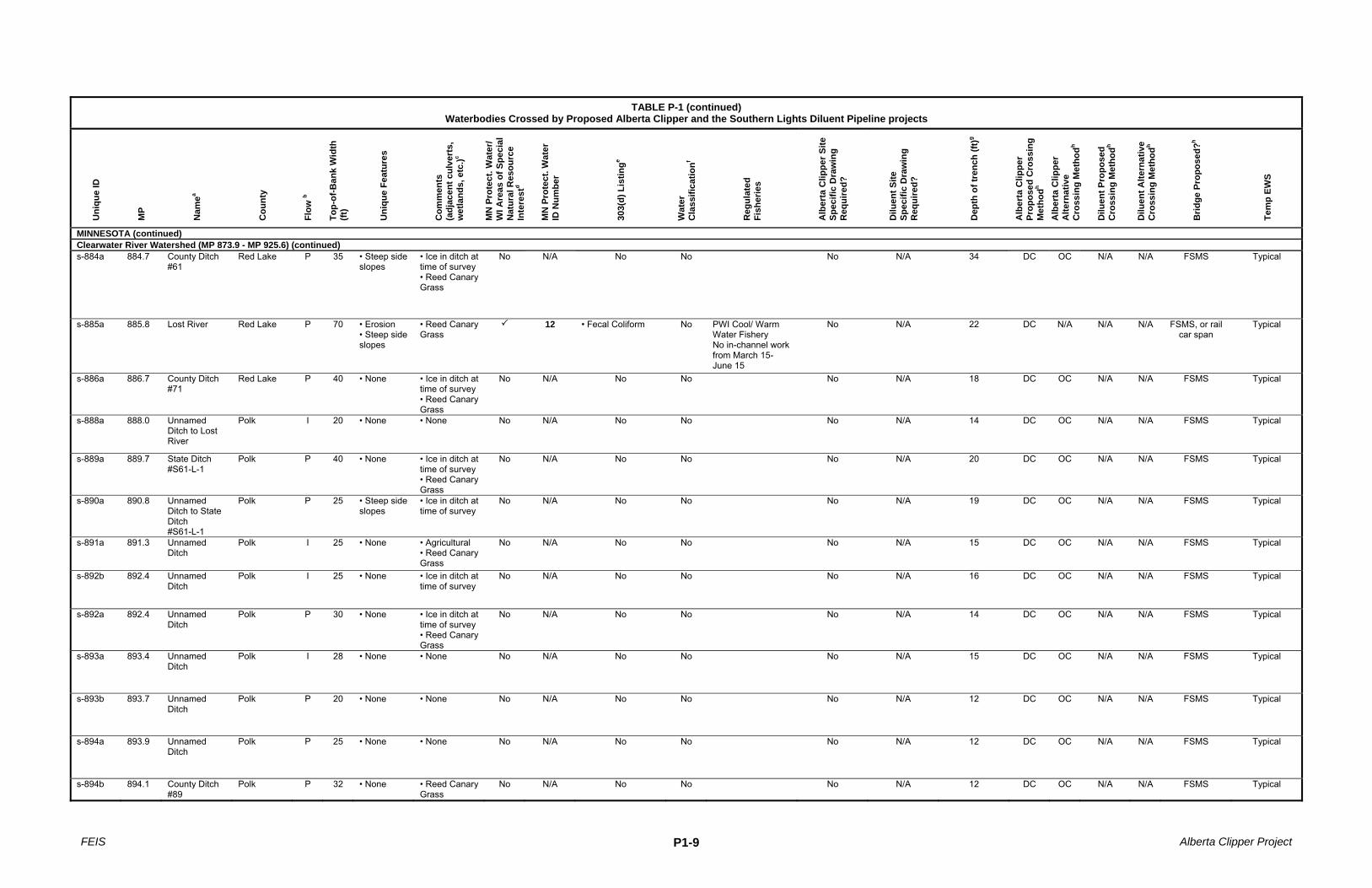
MINNESOTA (continued) Clearwater River Watershed (MP 873.9 - MP 925.6) (continued) s-884a 884.7 County Ditch
#61 Red Lake P 35 • Steep side
slopes • Ice in ditch at time of survey • Reed Canary Grass
No N/A No No No N/A 34 DC OC N/A N/A FSMS Typical
s-885a 885.8 Lost River Red Lake P 70 • Erosion • Steep side slopes
• Reed Canary Grass
12 • Fecal Coliform No PWI Cool/ Warm Water Fishery No in-channel work from March 15- June 15
No N/A 22 DC N/A N/A N/A FSMS, or rail car span
Typical
s-886a 886.7 County Ditch #71
Red Lake P 40 • None • Ice in ditch at time of survey • Reed Canary Grass
No N/A No No No N/A 18 DC OC N/A N/A FSMS Typical
s-888a 888.0 Unnamed Ditch to Lost River
Polk I 20 • None • None No N/A No No No N/A 14 DC OC N/A N/A FSMS Typical
s-889a 889.7 State Ditch #S61-L-1
Polk P 40 • None • Ice in ditch at time of survey • Reed Canary Grass
No N/A No No No N/A 20 DC OC N/A N/A FSMS Typical
s-890a 890.8 Unnamed Ditch to State Ditch #S61-L-1
Polk P 25 • Steep side slopes
• Ice in ditch at time of survey
No N/A No No No N/A 19 DC OC N/A N/A FSMS Typical
s-891a 891.3 Unnamed Ditch
Polk I 25 • None • Agricultural • Reed Canary Grass
No N/A No No No N/A 15 DC OC N/A N/A FSMS Typical
s-892b 892.4 Unnamed Ditch
Polk I 25 • None • Ice in ditch at time of survey
No N/A No No No N/A 16 DC OC N/A N/A FSMS Typical
s-892a 892.4 Unnamed Ditch
Polk P 30 • None • Ice in ditch at time of survey • Reed Canary Grass
No N/A No No No N/A 14 DC OC N/A N/A FSMS Typical
s-893a 893.4 Unnamed Ditch
Polk I 28 • None • None No N/A No No No N/A 15 DC OC N/A N/A FSMS Typical
s-893b 893.7 Unnamed Ditch
Polk P 20 • None • None No N/A No No No N/A 12 DC OC N/A N/A FSMS Typical
s-894a 893.9 Unnamed Ditch
Polk P 25 • None • None No N/A No No No N/A 12 DC OC N/A N/A FSMS Typical
s-894b 894.1 County Ditch #89
Polk P 32 • None • Reed Canary Grass
No N/A No No No N/A 12 DC OC N/A N/A FSMS Typical

FEIS Alberta Clipper Project P1-10
TABLE P-1 (continued)
Waterbodies Crossed by Proposed Alberta Clipper and the Southern Lights Diluent Pipeline projects
Uni
que
ID
MP
Nam
ea
Cou
nty
Flow
b
Top-
of-B
ank
Wid
th
(ft)
Uni
que
Feat
ures
Com
men
ts
(adj
acen
t cul
vert
s,
wet
land
s, e
tc.)c
MN
Pro
tect
. Wat
er/
WI A
reas
of S
peci
al
Nat
ural
Res
ourc
e In
tere
std
MN
Pro
tect
. Wat
er
ID N
umbe
r
303(
d) L
istin
ge
Wat
er
Cla
ssifi
catio
nf
Reg
ulat
ed
Fish
erie
s
Alb
erta
Clip
per S
ite
Spec
ific
Dra
win
g R
equi
red?
Dilu
ent S
ite
Spec
ific
Dra
win
g R
equi
red?
Dep
th o
f tre
nch
(ft)g
Alb
erta
Clip
per
Prop
osed
Cro
ssin
g M
etho
dh A
lber
ta C
lippe
r A
ltern
ativ
e C
ross
ing
Met
hodh
Dilu
ent P
ropo
sed
Cro
ssin
g M
etho
dh
Dilu
ent A
ltern
ativ
e C
ross
ing
Met
hodh
Brid
ge P
ropo
sed?
h
Tem
p EW
S
MINNESOTA (continued) Clearwater River Watershed (MP 873.9 - MP 925.6) (continued) s-894c 894.2 Unnamed
Ditch Polk I 23 • None • ESA 894.3a No N/A No No Yes N/A 9 DC OC N/A N/A FSMS Typical
s-895a 894.9 State Ditch #61 Branch 1L-1
Polk P 20 •None • Adjacent wetland (w-895a) • Reed Canary Grass
No N/A No No No N/A 12 OC N/A N/A FSMS Typical
N/A 902.0 Non-Jurisdictional Drain Across 113th Avenueo
Clearwater I N/A N/A N/A No N/A No No N/A N/A N/A DC OC N/A N/A FSMS Typical
s-902a 902.9 Tributary to Lost Rivers
Clearwater P 4 • Erosion • Adjacent wetland (w-902a) • Reed Canary Grass
No N/A No No No N/A 13 DC N/A N/A N/A FSMS Typical
s-903a 903.6 Tributary to Lost River
Clearwater I 12 • Erosion • Adjacent wetland (w-903b) • Forested • Some ice in channel at time of survey • Reed Canary Grass
No N/A No No No N/A 11 DC OC N/A N/A FSMS Typical
s-904a 904.0 Lost Rivers Clearwater P 18 • Erosion • Adjacent wetland (w-904e) • Reed Canary Grass • Agriculture
13 No No PWI Cool/ Warm Water Fishery No in-channel work from March 15- June 15
No N/A 19 DC N/A N/A N/A FSMS Typical
s-907a 907.1 Silver Creeks Clearwater P 20 • Erosion • Adjacent wetland (w-907e) • Agriculture
14 • Fecal Coliform No PWI Cool/ Warm Water Fishery No in-channel work from March 15- June 15
No N/A 13 DC N/A N/A N/A FSMS Typical
s-907b 907.4 Silver Creeks Clearwater P 12 • Erosion • Adjacent wetland (w-907a) • Reed Canary Grass • Agriculture
15 • Fecal Coliform No PWI Cool/ Warm Water Fishery No in-channel work from March 15- June 15
No N/A 15 DC N/A N/A N/A FSMS Typical
s-907c 907.7 Silver Creeks Clearwater P 15 • None • Adjacent wetland (w-907a) • Agriculture
16 • Fecal Coliform No PWI Cool/ Warm Water Fishery No in-channel work from March 15- June 15
No N/A 15 DC N/A N/A N/A FSMS Typical

FEIS Alberta Clipper Project P1-11
TABLE P-1 (continued)
Waterbodies Crossed by Proposed Alberta Clipper and the Southern Lights Diluent Pipeline projects
Uni
que
ID
MP
Nam
ea
Cou
nty
Flow
b
Top-
of-B
ank
Wid
th
(ft)
Uni
que
Feat
ures
Com
men
ts
(adj
acen
t cul
vert
s,
wet
land
s, e
tc.)c
MN
Pro
tect
. Wat
er/
WI A
reas
of S
peci
al
Nat
ural
Res
ourc
e In
tere
std
MN
Pro
tect
. Wat
er
ID N
umbe
r
303(
d) L
istin
ge
Wat
er
Cla
ssifi
catio
nf
Reg
ulat
ed
Fish
erie
s
Alb
erta
Clip
per S
ite
Spec
ific
Dra
win
g R
equi
red?
Dilu
ent S
ite
Spec
ific
Dra
win
g R
equi
red?
Dep
th o
f tre
nch
(ft)g
Alb
erta
Clip
per
Prop
osed
Cro
ssin
g M
etho
dh A
lber
ta C
lippe
r A
ltern
ativ
e C
ross
ing
Met
hodh
Dilu
ent P
ropo
sed
Cro
ssin
g M
etho
dh
Dilu
ent A
ltern
ativ
e C
ross
ing
Met
hodh
Brid
ge P
ropo
sed?
h
Tem
p EW
S
MINNESOTA (continued) Clearwater River Watershed (MP 873.9 - MP 925.6) (continued) s-909b 908.9 Tributary to
Silver Creek Clearwater I 7 • None • Adjacent
wetland (w-908a)
17 No No PWI Cool/ Warm Water Fishery No in-channel work from March 15- June 15
No N/A 12 DC N/A N/A N/A FSMS Typical
s-909a 909.1 Tributary to Silver Creek
Clearwater P 7 • Erosion • Adjacent wetland (w-909a) • Forested
No N/A No No No N/A 13 DC N/A N/A N/A FSMS Typical
s-913b 912.9 Tributary to Ruffy Brooks
Clearwater I 20 • None • Adjacent wetland (w-8r912d) • Stream was dry at time of evaluation • Grazed land heavily trampled by cattle
18 No No PWI Cool/ Warm Water Fishery No in-channel work from March 15- June 15
No No 9 DC OC DC OC Mat Typical
s-913a 913.1 Tributary to Ruffy Brooks
Clearwater S 25 • Seeps • Adjacent wetland (w-8r912d) • Seep is located south of ROW
No N/A No No No No 10 DC OC DC OC FSMS Typical
s-8r914a 914.2 Tributary to Ruffy Brooks
Clearwater I 10 • None • Adjacent wetland (w-8r914a)
No N/A No No No No 15 DC OC DC OC RC Typical
s-8r915b 915.2 Ruffy Brook Clearwater P 15 • None • Adjacent wetland (w-8r915b) • Beaver dam • Two channels • Reed Canary Grass
19 • Fecal Coliform No PWI Cool/ Warm Water Fishery No in-channel work from March 15- June 15
No No 13 DC N/A GB DC FSMS 50 x 100 both sides
s-8r915y 915.4 Tributary to Ruffy Brook
Clearwater I 3 • Seeps • Steep side slopes
• Adjacent wetland (w-8r915c)
No N/A No No No No 9 DC OC DC OC Mat 50 x 100 both sides
s-915c 915.6 Tributary to Ruffy Brooks
Clearwater I • None • Reed Canary Grass
No N/A No No Unknown, determination
pending
Unknown, determination
pending
Unknown, determination
pending
DC OC DC OC Unknown, determination
pending
Unknown, determination
pending

FEIS Alberta Clipper Project P1-12
TABLE P-1 (continued)
Waterbodies Crossed by Proposed Alberta Clipper and the Southern Lights Diluent Pipeline projects
Uni
que
ID
MP
Nam
ea
Cou
nty
Flow
b
Top-
of-B
ank
Wid
th
(ft)
Uni
que
Feat
ures
Com
men
ts
(adj
acen
t cul
vert
s,
wet
land
s, e
tc.)c
MN
Pro
tect
. Wat
er/
WI A
reas
of S
peci
al
Nat
ural
Res
ourc
e In
tere
std
MN
Pro
tect
. Wat
er
ID N
umbe
r
303(
d) L
istin
ge
Wat
er
Cla
ssifi
catio
nf
Reg
ulat
ed
Fish
erie
s
Alb
erta
Clip
per S
ite
Spec
ific
Dra
win
g R
equi
red?
Dilu
ent S
ite
Spec
ific
Dra
win
g R
equi
red?
Dep
th o
f tre
nch
(ft)g
Alb
erta
Clip
per
Prop
osed
Cro
ssin
g M
etho
dh A
lber
ta C
lippe
r A
ltern
ativ
e C
ross
ing
Met
hodh
Dilu
ent P
ropo
sed
Cro
ssin
g M
etho
dh
Dilu
ent A
ltern
ativ
e C
ross
ing
Met
hodh
Brid
ge P
ropo
sed?
h
Tem
p EW
S
MINNESOTA (continued) Clearwater River Watershed (MP 873.9 - MP 925.6) (continued) s-8r916x 916.6 West Four
Legged Lake Clearwater P 822 • None • None 20 No No PWI Cool/ Warm
Water Fishery No in-channel work from March 15- June 15
Yes Yes N/A HDD HDD N/A No See site specific
w-8r917b 917.7 East Four Legged Lake
Clearwater P 890 • None • Adjacent wetland (w-8r917b)
21 No No PWI Cool/ Warm Water Fishery No in-channel work from March 15- June 15
Unknown, determination
pending
Unknown, determination
pending
Unknown, determination
pending
OC/PP N/A OC/PP N/A No Unknown, determination
pending
s-922a 922.3 Tributary to Clearwater Rivern, s
Beltrami P 30 • Cutoff channels • Steep side slopes
• Adjacent wetland (w-8r922a) • Reed Canary Grass
22 No No PWI COLDWATER FISHERY No in-channel work from September 1- April 15
Yes Yes 11 DC DC FSMS Typical
s-922b 922.3 Clearwater Rivern, j, s
Beltrami P 70 •Steep side slopes
• Adjacent wetland (w-8r922a) • Reed Canary Grass
23 • Mercury 1B, 2A, 3B
PWI COLDWATER FISHERY No in-channel work from September 1 through April 15
Yes Yes 11 DC DC FSMS Typical
Mississippi River-Headwaters Watershed/Leech Lake Watershed (MP 925.6 - MP 1005.6) s-8r927b 927.0 Culverts Beltrami I 2 • None • Adjacent
wetland (w-8r926a)
No N/A No No Yes Yes 8 OC/PP N/A OC/PP OC None Typical
s-927a 927.2 Grant Creek Beltrami P 1010
• None • Adjacent wetland (w-8r926a) • Large inundated area due to Beaver activity • Referenced in MDNR letter dated 06/24/08
25 No No PWI Cool/ Warm Water Fishery No in-channel work from March 15- June 15
Yes Yes 9 OC/PP N/A OC/PP OC None Typical
s-930a 929.8 Grant Creeks Beltrami P 79 • Seeps • Gravel beds
• Adjacent wetland (w-8r929a) • ATV trails across the creek and ROW
26 No No PWI Cool/ Warm Water Fishery No in-channel work from March 15- June 15
Yes Yes 13 DC N/A GB DC FSMS Typical
s-8r932x 932.9 Grant Creeks Beltrami P 330 • None • Adjacent wetland (w-8r932b) • Snow ankle to waist deep surveyors could not get to waters edge
27 No No PWI Cool/ Warm Water Fishery No in-channel work from March 15- June 15
Yes Yes 14 DC N/A GB DC RC Typical

FEIS Alberta Clipper Project P1-13
TABLE P-1 (continued)
Waterbodies Crossed by Proposed Alberta Clipper and the Southern Lights Diluent Pipeline projects
Uni
que
ID
MP
Nam
ea
Cou
nty
Flow
b
Top-
of-B
ank
Wid
th
(ft)
Uni
que
Feat
ures
Com
men
ts
(adj
acen
t cul
vert
s,
wet
land
s, e
tc.)c
MN
Pro
tect
. Wat
er/
WI A
reas
of S
peci
al
Nat
ural
Res
ourc
e In
tere
std
MN
Pro
tect
. Wat
er
ID N
umbe
r
303(
d) L
istin
ge
Wat
er
Cla
ssifi
catio
nf
Reg
ulat
ed
Fish
erie
s
Alb
erta
Clip
per S
ite
Spec
ific
Dra
win
g R
equi
red?
Dilu
ent S
ite
Spec
ific
Dra
win
g R
equi
red?
Dep
th o
f tre
nch
(ft)g
Alb
erta
Clip
per
Prop
osed
Cro
ssin
g M
etho
dh A
lber
ta C
lippe
r A
ltern
ativ
e C
ross
ing
Met
hodh
Dilu
ent P
ropo
sed
Cro
ssin
g M
etho
dh
Dilu
ent A
ltern
ativ
e C
ross
ing
Met
hodh
Brid
ge P
ropo
sed?
h
Tem
p EW
S
MINNESOTA (continued) Mississippi River-Headwaters Watershed/Leech Lake Watershed (MP 925.6 - MP 1005.6) (continued) s-8r933x 933.7 Grant Creeks Beltrami P 500 • None • Adjacent
wetland (w-8r933b) • Crossing is located at a meander
28 No No PWI Cool/ Warm Water Fishery No in-channel work from March 15- June 15
Yes Yes 12 DC N/A GB DC RC Typical
s-8r934x 934.6 Drain/ Tributary to Grant Creek
Beltrami P 10 • None • Adjacent wetland (w-8r935a) • Reed Canary Grass
No N/A No No Yes Yes 9 DC OC GB DC FSMS Typical
s-939a 939.7 Mississippi River m, I, s
Beltrami P 190 • Steep side slopes (≈ 1280 apart)
• Adjacent wetland (w-8r939b) • Segment of Mississippi River that feeds Lake Irving • Reed Canary Grass
29 No 2B, 3C PWI Cool/ Warm Water Fishery No in-channel work from March 15- June 15
Yes Yes N/A HDD DC HDD DC None See site specific
NHD941r
(Survey Pending)
941.8 Unnamed Tributarys
Beltrami
NHD942r
(Survey Pending)
942.3 Unnamed Tributarys
Beltrami
s-943a 943.5 Unnamed Tributarys
Beltrami I • None • Adjacent wetland (w-943i) • Reed Canary Grass
No N/A No No Unknown, determination
pending
Unknown, determination
pending
Unknown, determination
pending
DC OC DC OC Unknown, determination
pending
Unknown, determination
pending
NHD943.9r
(Survey Pending)
943.9 Unnamed Tributarys
Hubbard
s-944a 944.4 Tributary to the Necktie Rivern
Hubbard P 600 • None • Adjacent wetland (w-944d) • Channel partially blocked by beaver activity • Waterbody predominantly is an emergent wetland and flows into a tamarack swamp
30 No No PWI COLDWATER FISHERY No in-channel work from September 1-April 15
No No 8 OC GB OC Mat Typical

FEIS Alberta Clipper Project P1-14
TABLE P-1 (continued)
Waterbodies Crossed by Proposed Alberta Clipper and the Southern Lights Diluent Pipeline projects
Uni
que
ID
MP
Nam
ea
Cou
nty
Flow
b
Top-
of-B
ank
Wid
th
(ft)
Uni
que
Feat
ures
Com
men
ts
(adj
acen
t cul
vert
s,
wet
land
s, e
tc.)c
MN
Pro
tect
. Wat
er/
WI A
reas
of S
peci
al
Nat
ural
Res
ourc
e In
tere
std
MN
Pro
tect
. Wat
er
ID N
umbe
r
303(
d) L
istin
ge
Wat
er
Cla
ssifi
catio
nf
Reg
ulat
ed
Fish
erie
s
Alb
erta
Clip
per S
ite
Spec
ific
Dra
win
g R
equi
red?
Dilu
ent S
ite
Spec
ific
Dra
win
g R
equi
red?
Dep
th o
f tre
nch
(ft)g
Alb
erta
Clip
per
Prop
osed
Cro
ssin
g M
etho
dh A
lber
ta C
lippe
r A
ltern
ativ
e C
ross
ing
Met
hodh
Dilu
ent P
ropo
sed
Cro
ssin
g M
etho
dh
Dilu
ent A
ltern
ativ
e C
ross
ing
Met
hodh
Brid
ge P
ropo
sed?
h
Tem
p EW
S
MINNESOTA (continued) Mississippi River-Headwaters Watershed/Leech Lake Watershed (MP 925.6 - MP 1005.6) (continued) s-8r946a 945.5 Tributary to
the Necktie Rivern, s
Hubbard P 240 • None • Adjacent wetlands (w-945g & w-946a)
31 No No PWI COLDWATER FISHERY No in-channel work from September 1- April 15
Yes Yes 9 OC GB OC None Typical
s-947a 947.2 Necktie Rivern,
s Hubbard P 18 • None • Adjacent
wetland (w-947c) • Associated with a large bog
32 No 1B, 2A, 3B
PWI COLDWATER FISHERY No in-channel work from September 1-April 15
Yes Yes 11 DC OC/PP
DC OC/PP
FSMS Typical
s-948a 948.5 Ditchs Hubbard P 15 • None • Adjacent wetland (w-948b) • Part of a large tamarack / shrub wetland • Water flow toward Little Midge Lake
No N/A No No No No 12 DC OC GB DC FSMS Typical
s-955a 955.8 Pike's Bay Channell
Cass P 100 • None • Adjacent wetland (w-955c)
33 No No PWI Cool/ Warm Water Fishery No in-channel work from March 15- June 15
Yes Yes N/A HDD N/A HDD N/A None See site specific
NHD963r
(Survey Pending)
963.5 Unnamed Stream
Cass
s-964a 964.2 Upper Sucker Lake
Cass P 300 • None • Adjacent wetland (w-964a)
34 No No PWI Cool/ Warm Water Fishery No in-channel work from March 15- June 15
Yes Yes N/A PP OC GB OC None See site specific
s-967a 967.8 Unnamed Tributary
Cass P • None • Adjacent wetland (w-967c) • Channel blocked due to beaver dam • Reed Canary Grass
No N/A No No Unknown, determination
pending
Unknown, determination
pending
Unknown, determination
pending
DC OC DC OC Unknown, determination
pending
Unknown, determination
pending
s-968a 968.1 Portage Creeks
Cass P 100 • None • Adjacent wetland (w-968a)
No N/A No No Yes Yes N/A PP OC GB PP None Typical
s-975a 975.0 Unknown Cass S 6 • None • Adjacent wetland (w-974a) • Waterbody associated with Sixmile Lake
No N/A No No No No 12 PP OC PP OC Mat Typical
FEIS Alberta Clipper Project P1-15
TABLE P-1 (continued)
Waterbodies Crossed by Proposed Alberta Clipper and the Southern Lights Diluent Pipeline projects
Uni
que
ID
MP
Nam
ea
Cou
nty
Flow
b
Top-
of-B
ank
Wid
th
(ft)
Uni
que
Feat
ures
Com
men
ts
(adj
acen
t cul
vert
s,
wet
land
s, e
tc.)c
MN
Pro
tect
. Wat
er/
WI A
reas
of S
peci
al
Nat
ural
Res
ourc
e In
tere
std
MN
Pro
tect
. Wat
er
ID N
umbe
r
303(
d) L
istin
ge
Wat
er
Cla
ssifi
catio
nf
Reg
ulat
ed
Fish
erie
s
Alb
erta
Clip
per S
ite
Spec
ific
Dra
win
g R
equi
red?
Dilu
ent S
ite
Spec
ific
Dra
win
g R
equi
red?
Dep
th o
f tre
nch
(ft)g
Alb
erta
Clip
per
Prop
osed
Cro
ssin
g M
etho
dh A
lber
ta C
lippe
r A
ltern
ativ
e C
ross
ing
Met
hodh
Dilu
ent P
ropo
sed
Cro
ssin
g M
etho
dh
Dilu
ent A
ltern
ativ
e C
ross
ing
Met
hodh
Brid
ge P
ropo
sed?
h
Tem
p EW
S
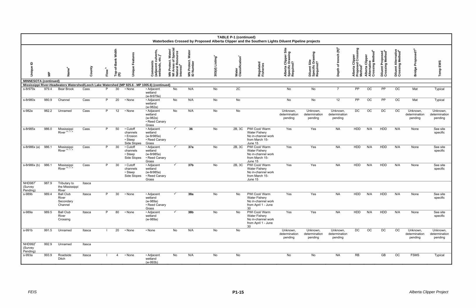
MINNESOTA (continued) Mississippi River-Headwaters Watershed/Leech Lake Watershed (MP 925.6 - MP 1005.6) (continued) s-8r979x 979.4 Bear Brook Cass P 30 • None • Adjacent
wetland (w-8r979a)
No N/A No 2C No No 7 PP OC PP OC Mat Typical
s-8r980x 980.9 Channel Cass P 20 • None • Adjacent wetland (w-982a)
No N/A No No No No 12 PP OC PP OC Mat Typical
s-982a 982.2 Unnamed Cass P 12 • None • Adjacent wetland (w-982a) • Reed Canary Grass
No N/A No No Unknown, determination
pending
Unknown, determination
pending
Unknown, determination
pending
DC OC DC OC Unknown, determination
pending
Unknown, determination
pending
s-8r985x 986.0 Mississippi River m, l, i, s
Cass P 50 • Cutoff channels • Erosion • Steep Side Slopes
• Adjacent wetland (w-8r985a) • Reed Canary Grass
36 No 2B, 3C PWI Cool/ Warm Water Fishery No in-channel work from March 15- June 15
Yes Yes NA HDD N/A HDD N/A None See site specific
s-8r986x (a) 986.1 Mississippi River m, l, i, s
Cass P 30 • Cutoff channels • Steep Side Slopes
• Adjacent wetland (w-8r985a) • Reed Canary Grass
37a No 2B, 3C PWI Cool/ Warm Water Fishery No in-channel work from March 15- June 15
Yes Yes NA HDD N/A HDD N/A None See site specific
s-8r986x (b) 986.1 Mississippi River m, l, i, s
Cass P 30 • Cutoff channels • Steep Side Slopes
• Adjacent wetland (w-8r985a) • Reed Canary Grass
37b No 2B, 3C PWI Cool/ Warm Water Fishery No in-channel work from March 15- June 15
Yes Yes NA HDD N/A HDD N/A None See site specific
NHD987r
(Survey Pending)
987.9 Tributary to the Mississippi River
Itasca
s-989b 989.4 Ball Club River Secondary Channel
Itasca P 30 • None • Adjacent wetland (w-989a) • Reed Canary Grass
38a No No PWI Cool/ Warm Water Fishery No in-channel work from April 1 - June 30
Yes Yes NA HDD N/A HDD N/A None See site specific
s-989a 989.5 Ball Club River Crossing
Itasca P 80 • None • Adjacent wetland (w-989a)
38b No No PWI Cool/ Warm Water Fishery No in-channel work from April 1 - June 30
Yes Yes NA HDD N/A HDD N/A None See site specific
s-991b 991.5 Unnamed Itasca I 20 • None • None No N/A No No Unknown, determination
pending
Unknown, determination
pending
Unknown, determination
pending
DC OC DC OC Unknown, determination
pending
Unknown, determination
pending
NHD992r
(Survey Pending)
992.9 Unnamed Itasca
s-993a 993.9 Roadside Ditch
Itasca I 4 • None • Adjacent wetland (w-993b)
No N/A No No No No NA RB GB OC FSMS Typical

FEIS Alberta Clipper Project P1-16
TABLE P-1 (continued)
Waterbodies Crossed by Proposed Alberta Clipper and the Southern Lights Diluent Pipeline projects
Uni
que
ID
MP
Nam
ea
Cou
nty
Flow
b
Top-
of-B
ank
Wid
th
(ft)
Uni
que
Feat
ures
Com
men
ts
(adj
acen
t cul
vert
s,
wet
land
s, e
tc.)c
MN
Pro
tect
. Wat
er/
WI A
reas
of S
peci
al
Nat
ural
Res
ourc
e In
tere
std
MN
Pro
tect
. Wat
er
ID N
umbe
r
303(
d) L
istin
ge
Wat
er
Cla
ssifi
catio
nf
Reg
ulat
ed
Fish
erie
s
Alb
erta
Clip
per S
ite
Spec
ific
Dra
win
g R
equi
red?
Dilu
ent S
ite
Spec
ific
Dra
win
g R
equi
red?
Dep
th o
f tre
nch
(ft)g
Alb
erta
Clip
per
Prop
osed
Cro
ssin
g M
etho
dh A
lber
ta C
lippe
r A
ltern
ativ
e C
ross
ing
Met
hodh
Dilu
ent P
ropo
sed
Cro
ssin
g M
etho
dh
Dilu
ent A
ltern
ativ
e C
ross
ing
Met
hodh
Brid
ge P
ropo
sed?
h
Tem
p EW
S
MINNESOTA (continued) Mississippi River-Headwaters Watershed/Leech Lake Watershed (MP 925.6 - MP 1005.6) (continued) s-994a 994.2 Unnamed Itasca I 10 • None • Adjacent
wetland (w-993b)
No N/A No No Unknown, determination
pending
Unknown, determination
pending
Unknown, determination
pending
DC OC DC OC Unknown, determination
pending
Unknown, determination
pending
s-995a 995.3 Deer River Itasca P 30 • None • Adjacent wetland (w-994a)
39 No No PWI Cool/ Warm Water Fishery No in-channel work from April 1 - June 30
Yes Yes NA HDD N/A HDD N/A None See site specific
s-995b 995.4 Ditch Itasca I 12 • None • Adjacent wetland (w-994a) • Ditch used to regulate water levels on adjacent farm
No N/A No No Yes Yes NA HDD N/A HDD N/A None See site specific
s-995c 995.4 Ditch Itasca I 12 • None • Adjacent wetland (w-994a) • Ditch used to regulate water levels on adjacent farm
No N/A No No Yes Yes NA HDD N/A HDD N/A None See site specific
s-995d 995.5 Ditch Itasca I 12 • None • Adjacent wetland (w-994a) • Ditch used to regulate water levels on adjacent farm
No N/A No No Yes Yes NA HDD N/A HDD N/A None See site specific
s-996a 996.1 Unnamed Itasca I 15 • None • Adjacent wetland (w-8r996a) • Grass swale in agricultural field • Reed Canary Grass
No N/A No No Unknown, determination
pending
Unknown, determination
pending
Unknown, determination
pending
DC OC DC OC Unknown, determination
pending
Unknown, determination
pending
s-996b 996.8 Canal/Ditch Itasca I 10 • None • Adjacent wetland (w-8r996d) • Reed Canary Grass
No N/A No No Unknown, determination
pending
Unknown, determination
pending
Unknown, determination
pending
DC OC DC OC Unknown, determination
pending
Unknown, determination
pending
s-8r1004x 1004.1 Bass Brooks Itasca P 125 • None • Adjacent wetland (w-8r1004b)
40 No No PWI Cool/ Warm Water Fishery No in-channel work from April 1 - June 30
Yes Yes NA DC OC GB DC FSMS Typical

FEIS Alberta Clipper Project P1-17
TABLE P-1 (continued)
Waterbodies Crossed by Proposed Alberta Clipper and the Southern Lights Diluent Pipeline projects
Uni
que
ID
MP
Nam
ea
Cou
nty
Flow
b
Top-
of-B
ank
Wid
th
(ft)
Uni
que
Feat
ures
Com
men
ts
(adj
acen
t cul
vert
s,
wet
land
s, e
tc.)c
MN
Pro
tect
. Wat
er/
WI A
reas
of S
peci
al
Nat
ural
Res
ourc
e In
tere
std
MN
Pro
tect
. Wat
er
ID N
umbe
r
303(
d) L
istin
ge
Wat
er
Cla
ssifi
catio
nf
Reg
ulat
ed
Fish
erie
s
Alb
erta
Clip
per S
ite
Spec
ific
Dra
win
g R
equi
red?
Dilu
ent S
ite
Spec
ific
Dra
win
g R
equi
red?
Dep
th o
f tre
nch
(ft)g
Alb
erta
Clip
per
Prop
osed
Cro
ssin
g M
etho
dh A
lber
ta C
lippe
r A
ltern
ativ
e C
ross
ing
Met
hodh
Dilu
ent P
ropo
sed
Cro
ssin
g M
etho
dh
Dilu
ent A
ltern
ativ
e C
ross
ing
Met
hodh
Brid
ge P
ropo
sed?
h
Tem
p EW
S
MINNESOTA (continued) Prairie-Willow Watershed (MP 1005.6 - MP 1026.8) s-1011a 1010.0 Prairie River Itasca P 400 • None • Adjacent
wetland (w-8r1010c) • Reed Canary Grass • The east side appears to have steeper banks with large trees
41 No No PWI Cool/ Warm Water Fishery No in-channel work from April 1 - June 30
Yes Yes NA HDD N/A HDD N/A None See site specific
s-8r1016a 1016.1 Tributary to Mississippi River
Itasca P 15 • None • Adjacent wetland (w-8r1016a) • Reed Canary Grass • Channel through pasture
43 No No PWI Cool/ Warm Water Fishery No in-channel work from April 1 - June 30
Yes Yes 11 DC OC GB DC FSMS Typical
s-1019a 1019.5 Canal/Ditch Itasca I • None • Adjacent wetland (w-1022a)
No N/A No No Unknown, determination
pending
Unknown, determination
pending
Unknown, determination
pending
DC OC DC OC Unknown, determination
pending
Unknown, determination
pending
NHD1020.2r
(Survey Pending)
1020.2 Canal/Ditch Itasca
NHD1020.5r
(Survey Pending)
1020.5 Canal/Ditch Itasca
s-1025a 1024.2 Swan Rivers Itasca P 100 • Steep side slopes
• Adjacent wetlands (w-1025a & w-1026a) • Reed Canary Grass
44 • Dissolved Oxygen• Mercury
No PWI Cool/ Warm Water Fishery No in-channel work from April 1 - June 30
Yes Yes 20 DC OC GB DC RC East side only
s-1026a 1024.7 Tributary to Swan River
Itasca P 10 • Cutoff channels
• Adjacent wetland (w-1026c) • Reed Canary Grass • The Stream channel is not well defined due to hummock sedges
No N/A No No No No 10 OC/PP GB OC/PP
None Typical
NHD1026r
(Survey Pending)
1026.1 Unnamed Tributarys
Itasca

FEIS Alberta Clipper Project P1-18
TABLE P-1 (continued)
Waterbodies Crossed by Proposed Alberta Clipper and the Southern Lights Diluent Pipeline projects
Uni
que
ID
MP
Nam
ea
Cou
nty
Flow
b
Top-
of-B
ank
Wid
th
(ft)
Uni
que
Feat
ures
Com
men
ts
(adj
acen
t cul
vert
s,
wet
land
s, e
tc.)c
MN
Pro
tect
. Wat
er/
WI A
reas
of S
peci
al
Nat
ural
Res
ourc
e In
tere
std
MN
Pro
tect
. Wat
er
ID N
umbe
r
303(
d) L
istin
ge
Wat
er
Cla
ssifi
catio
nf
Reg
ulat
ed
Fish
erie
s
Alb
erta
Clip
per S
ite
Spec
ific
Dra
win
g R
equi
red?
Dilu
ent S
ite
Spec
ific
Dra
win
g R
equi
red?
Dep
th o
f tre
nch
(ft)g
Alb
erta
Clip
per
Prop
osed
Cro
ssin
g M
etho
dh A
lber
ta C
lippe
r A
ltern
ativ
e C
ross
ing
Met
hodh
Dilu
ent P
ropo
sed
Cro
ssin
g M
etho
dh
Dilu
ent A
ltern
ativ
e C
ross
ing
Met
hodh
Brid
ge P
ropo
sed?
h
Tem
p EW
S
MINNESOTA (continued) St. Louis River Watershed/Kettle River Watershed (MP 1026.8 - MP 1078.9) s-1029a 1027.6 Constructed
Ditch Itasca I 15 • None • Adjacent
wetland (w-1029a)
No N/A No No No No 9 DC OC DC OC Mat Typical
s-1029b 1027.8 Constructed Ditch
Itasca I 15 • None • Adjacent wetland (w-1029c) • Reed Canary Grass • Waterbody connects wetlands north and south of the ROW
No N/A No No No No 9 DC OC DC OC Mat Typical
s-1029c 1028.2 Bruce Creek Itasca S 12 • None • Adjacent wetland (w-1029f) • Reed Canary Grass • Waterbody has been straightened and lies adjacent to Highway 65
45 No No PWI Cool/ Warm Water Fishery No in-channel work from April 1- June 30
No No NA RB DC GB DC FSMS Typical
s-8r1033x 1033.9 Ditch Itasca P 20 • None • Adjacent wetland (w-8r1038d) • Water channel has flooded out of it's banks and into the adjacent wetland
No N/A No No Yes Yes 13 OC N/A OC N/A Mat Typical
NHD1035r
(Survey Pending)
1035.1 Ditch Itasca
s-8r1035x 1035.4 Ditch Aitkin P 20 • None • Adjacent wetland (w-8r1038d)
No N/A No No No No 11 OC N/A OC N/A Mat Typical
s-1038a 1036.2 Ditch Aitkin P 15 • None • Adjacent wetland (w-8r1038d) • Located within an extensive peatland
No N/A No No No No 7 OC N/A OC N/A Mat Typical

FEIS Alberta Clipper Project P1-19
TABLE P-1 (continued)
Waterbodies Crossed by Proposed Alberta Clipper and the Southern Lights Diluent Pipeline projects
Uni
que
ID
MP
Nam
ea
Cou
nty
Flow
b
Top-
of-B
ank
Wid
th
(ft)
Uni
que
Feat
ures
Com
men
ts
(adj
acen
t cul
vert
s,
wet
land
s, e
tc.)c
MN
Pro
tect
. Wat
er/
WI A
reas
of S
peci
al
Nat
ural
Res
ourc
e In
tere
std
MN
Pro
tect
. Wat
er
ID N
umbe
r
303(
d) L
istin
ge
Wat
er
Cla
ssifi
catio
nf
Reg
ulat
ed
Fish
erie
s
Alb
erta
Clip
per S
ite
Spec
ific
Dra
win
g R
equi
red?
Dilu
ent S
ite
Spec
ific
Dra
win
g R
equi
red?
Dep
th o
f tre
nch
(ft)g
Alb
erta
Clip
per
Prop
osed
Cro
ssin
g M
etho
dh A
lber
ta C
lippe
r A
ltern
ativ
e C
ross
ing
Met
hodh
Dilu
ent P
ropo
sed
Cro
ssin
g M
etho
dh
Dilu
ent A
ltern
ativ
e C
ross
ing
Met
hodh
Brid
ge P
ropo
sed?
h
Tem
p EW
S
MINNESOTA (continued) St. Louis River Watershed/Kettle River Watershed (MP 1026.8 - MP 1078.9) (continued) s-8r1038x 1038.1 Ditch St. Louis P 500 • None • Adjacent
wetland (w-8r1038d) • There is a 18 inch culvert under the railroad and beavers have blocked the drainage to the north. • Reed Canary Grass
No N/A No No No No 13 OC N/A OC N/A Mat Typical
s-1042a 1040.8 Ditch St. Louis S 12 • None • Adjacent wetland (w-8r1042b) • Two Crossings • Reed Canary Grass
No N/A No No No No 7 DC OC DC OC Mat Typical
NHD1041r
(Survey Pending)
1041.8 Unnamed St. Louis
s-8r1042x 1042.5 Ditchp St. Louis I 6 • None • Adjacent wetland (w-8r1042b)
No N/A No No No No 10 DC OC DC OC Mat Typical
s-8r1042y 1042.9 Pond St. Louis P 50 • None • Adjacent wetland (w-8r1043a) • Man made excavated pond in a sphagnum moss bog
No N/A No No No No 7 OC N/A OC N/A Mat Typical
s-1046a 1044.3 Ditch St. Louis S 30 • None • Adjacent wetland (w-1045e) • Reed Canary Grass
No N/A No No No No 18 DC OC GB OC Mat Typical
s-1044b 1044.9 Tributary to Floodwood River
St. Louis P 3 • None • Adjacent wetland (w-1045fw1)
No N/A No No No No 9 OC N/A GB OC Mat Typical
s-1045b 1045.0 Tributary to Floodwood River
St. Louis P 150 • None • Adjacent wetland (w-1045fw1)
46 No No PWI Cool/ Warm Water Fishery No in-channel work from April 1 - June 30
No No 10 OC N/A GB OC FSMS Typical

FEIS Alberta Clipper Project P1-20
TABLE P-1 (continued)
Waterbodies Crossed by Proposed Alberta Clipper and the Southern Lights Diluent Pipeline projects
Uni
que
ID
MP
Nam
ea
Cou
nty
Flow
b
Top-
of-B
ank
Wid
th
(ft)
Uni
que
Feat
ures
Com
men
ts
(adj
acen
t cul
vert
s,
wet
land
s, e
tc.)c
MN
Pro
tect
. Wat
er/
WI A
reas
of S
peci
al
Nat
ural
Res
ourc
e In
tere
std
MN
Pro
tect
. Wat
er
ID N
umbe
r
303(
d) L
istin
ge
Wat
er
Cla
ssifi
catio
nf
Reg
ulat
ed
Fish
erie
s
Alb
erta
Clip
per S
ite
Spec
ific
Dra
win
g R
equi
red?
Dilu
ent S
ite
Spec
ific
Dra
win
g R
equi
red?
Dep
th o
f tre
nch
(ft)g
Alb
erta
Clip
per
Prop
osed
Cro
ssin
g M
etho
dh A
lber
ta C
lippe
r A
ltern
ativ
e C
ross
ing
Met
hodh
Dilu
ent P
ropo
sed
Cro
ssin
g M
etho
dh
Dilu
ent A
ltern
ativ
e C
ross
ing
Met
hodh
Brid
ge P
ropo
sed?
h
Tem
p EW
S
MINNESOTA (continued) St. Louis River Watershed/Kettle River Watershed (MP 1026.8 - MP 1078.9) (continued) s-1046b 1046.0 Savanna
Rivers St. Louis P 45 • None • Adjacent
wetland (w-1046fw1 & w-1056fw2)
47 No No PWI Cool/ Warm Water Fishery No in-channel work from April 1 - June 30
No No 30 DC OC DC OC RC or RF East side only, out of wetland
NHD1047r
(Survey Pending)
1047.6 Unnamed Tributary
St. Louis
s-8r1050x 1050.1 Tributary to St. Louis River
St. Louis P 30 • None • Reed Canary Grass
48 No No PWI Cool/ Warm Water Fishery No in-channel work from April 1 - June 30
No No 16 DC OC GB DC FSMS Typical, west side only
s-1050a 1050.4 Tributary to St. Louis River
St. Louis I 4 • None • Adjacent wetland (w-8r1050b)
No N/A No No Unknown, determination
pending
Unknown, determination
pending
Unknown, determination
pending
DC OC DC OC Unknown, determination
pending
Unknown, determination
pending
s-8r1051x 1052.0 Tributary to St. Louis River
St. Louis P 15 • None • Adjacent wetland (w-8r1052e)
49 No No PWI Cool/ Warm Water Fishery No in-channel work from April 1 - June 30
No No 11 DC OC GB DC FSMS Typical
s-1052a 1052.1 Tributary to St. Louis River
St. Louis I 5 • None • Adjacent wetland (w-8r1052g)
No N/A No No Unknown, determination
pending
Unknown, determination
pending
Unknown, determination
pending
DC OC DC OC Unknown, determination
pending
Unknown, determination
pending
s-8r1052x 1052.7 Ahmik River (Mirbat Creek)s
St. Louis P 22 • Seeps • Adjacent wetland (w-8r1052a) • Reed Canary Grass
50 No No PWI Cool/ Warm Water Fishery No in-channel work from April 1 - June 30
No No 13 DC OC GB DC FSMS West side only
s-8r1058a 1058.6 Tributary to Dead Fish Lake
St. Louis P 10 • None • Due to innaccessible bog conditions, estimates are based on GIS measurements. • Adjacent wetland (w-8r1058b)
No N/A No No Unknown, determination
pending
Unknown, determination
pending
Unknown, determination
pending
OC/PP N/A OC/PP N/A Unknown, determination
pending
Unknown, determination
pending
s-8r1062a 1062.5 Stoney Brook Carlton P 15 • None • Adjacent wetland (w-8r1062a) • Reed Canary Grass
No N/A No No Unknown, determination
pending
Unknown, determination
pending
Unknown, determination
pending
DC OC DC OC Unknown, determination
pending
Unknown, determination
pending

FEIS Alberta Clipper Project P1-21
TABLE P-1 (continued)
Waterbodies Crossed by Proposed Alberta Clipper and the Southern Lights Diluent Pipeline projects
Uni
que
ID
MP
Nam
ea
Cou
nty
Flow
b
Top-
of-B
ank
Wid
th
(ft)
Uni
que
Feat
ures
Com
men
ts
(adj
acen
t cul
vert
s,
wet
land
s, e
tc.)c
MN
Pro
tect
. Wat
er/
WI A
reas
of S
peci
al
Nat
ural
Res
ourc
e In
tere
std
MN
Pro
tect
. Wat
er
ID N
umbe
r
303(
d) L
istin
ge
Wat
er
Cla
ssifi
catio
nf
Reg
ulat
ed
Fish
erie
s
Alb
erta
Clip
per S
ite
Spec
ific
Dra
win
g R
equi
red?
Dilu
ent S
ite
Spec
ific
Dra
win
g R
equi
red?
Dep
th o
f tre
nch
(ft)g
Alb
erta
Clip
per
Prop
osed
Cro
ssin
g M
etho
dh A
lber
ta C
lippe
r A
ltern
ativ
e C
ross
ing
Met
hodh
Dilu
ent P
ropo
sed
Cro
ssin
g M
etho
dh
Dilu
ent A
ltern
ativ
e C
ross
ing
Met
hodh
Brid
ge P
ropo
sed?
h
Tem
p EW
S
MINNESOTA (continued) St. Louis River Watershed/Kettle River Watershed (MP 1026.8 - MP 1078.9) (continued) s-8r1063 1064.3 Tributary to
Dead Fish Lake
Carlton P 20 • None • Due to innaccessible bog conditions, estimates are based on GIS measurements. • Adjacent wetland (w-8r1063a)
No N/A No No Unknown, determination
pending
Unknown, determination
pending
Unknown, determination
pending
DC OC DC OC Unknown, determination
pending
Unknown, determination
pending
s-8r1065a 1064.8 Tributary to Rice Portage Lakes
Carlton P 3 • None • Due to innaccessible bog conditions, estimates are based on GIS measurements. • Adjacent wetland (w-8r1064a)
No N/A No No Unknown, determination
pending
Unknown, determination
pending
Unknown, determination
pending
OC/PP N/A OC OC/PP
Unknown, determination
pending
Unknown, determination
pending
NHD1070 (Survey Pending)
1070.1 Tributary to Otter Creek
Carlton
s-1073b 1071.2 Tributary to Little Otter Creeks
Carlton P 200 • None • Open water within wetland • Adjacent wetland (w-1072a)
No N/A No No Unknown, determination
pending
Unknown, determination
pending
Unknown, determination
pending
OC/PP N/A OC N/A Unknown, determination
pending
Unknown, determination
pending
s-1073a 1071.5 Tributary to Little Otter Creeks
Carlton P 10 • Gravel beds
• A perennial stream that flows to the south through a wetland • Adjacent wetland (w-1073a) • Beaver dams • Reed Canary Grass
51 No No PWI Cool/ Warm Water Fishery No in-channel work from April 1 - June 30
Unknown, determination
pending
Unknown, determination
pending
Unknown, determination
pending
DC OC GB OC Unknown, determination
pending
Unknown, determination
pending
s-1074a 1072.9 Pond Carlton P 100 • None • Excavated pond within the ROW • Adjacent wetland (w-1074d) • Reed Canary Grass
No N/A No No Unknown, determination
pending
Unknown, determination
pending
Unknown, determination
pending
OC/PP N/A OC/PP N/A Unknown, determination
pending
Unknown, determination
pending

FEIS Alberta Clipper Project P1-22
TABLE P-1 (continued)
Waterbodies Crossed by Proposed Alberta Clipper and the Southern Lights Diluent Pipeline projects
Uni
que
ID
MP
Nam
ea
Cou
nty
Flow
b
Top-
of-B
ank
Wid
th
(ft)
Uni
que
Feat
ures
Com
men
ts
(adj
acen
t cul
vert
s,
wet
land
s, e
tc.)c
MN
Pro
tect
. Wat
er/
WI A
reas
of S
peci
al
Nat
ural
Res
ourc
e In
tere
std
MN
Pro
tect
. Wat
er
ID N
umbe
r
303(
d) L
istin
ge
Wat
er
Cla
ssifi
catio
nf
Reg
ulat
ed
Fish
erie
s
Alb
erta
Clip
per S
ite
Spec
ific
Dra
win
g R
equi
red?
Dilu
ent S
ite
Spec
ific
Dra
win
g R
equi
red?
Dep
th o
f tre
nch
(ft)g
Alb
erta
Clip
per
Prop
osed
Cro
ssin
g M
etho
dh A
lber
ta C
lippe
r A
ltern
ativ
e C
ross
ing
Met
hodh
Dilu
ent P
ropo
sed
Cro
ssin
g M
etho
dh
Dilu
ent A
ltern
ativ
e C
ross
ing
Met
hodh
Brid
ge P
ropo
sed?
h
Tem
p EW
S
MINNESOTA (continued) St. Louis River Watershed/Kettle River Watershed (MP 1026.8 - MP 1078.9) (continued) NHD1072 (Survey Pending)
1072.9 Tributary to Little Otter Creek
Carlton
s-1076a 1074.3 Little Otter Creekn, s
Carlton P 15 • None • Adjacent wetland (w-1075c) • Reed Canary Grass • Large Granite outcroppings are scattered throughout the wetland along the stream
52 No 1B, 2A, 3B
PWI COLDWATER FISHERY No in-channel work from September 15-April 30
No No 11 DC OC DC OC FSMS Typical
Nemadji River Watershed/St. Louis River Watershed (MP 1078.9 - MP 1097.8) NHD1080r
(Survey Pending)
1080.7 Unnamed Carlton
s-8r1081a 1081.6 Tributary to Clear Creeks
Carlton I 2 • None • None 53 No No PWI Cool/ Warm Water Fishery No in-channel work from April 1 - June 30
Yes Yes 10 DC OC GB DC FSMS Outside of treeline (>50')
on each side of waterbody
s-1082a 1082.6 Unnamed Carlton S • None • Adjacent wetland (w-1082ws1) • Reed Canary Grass
No N/A No No Unknown, determination
pending
Unknown, determination
pending
Unknown, determination
pending
DC OC DC OC Unknown, determination
pending
Unknown, determination
pending
s-1083e 1083.3 Unnameds Carlton I 50 • None • Adjacent wetland (w-8r1084x) • Reed Canary Grass
No N/A No No Unknown, determination
pending
Unknown, determination
pending
Unknown, determination
pending
DC OC DC OC Unknown, determination
pending
Unknown, determination
pending
s-1083d1 1083.5 Unnameds Carlton I 50 • None • Adjacent wetland (w-1083ws1) • Reed Canary Grass
No N/A No No Unknown, determination
pending
Unknown, determination
pending
Unknown, determination
pending
DC OC DC OC Unknown, determination
pending
Unknown, determination
pending
s-1083d2 1083.5 Unnamed Carlton I 50 • None • Adjacent wetland (w-8r1083z) • Reed Canary Grass
No N/A No No Unknown, determination
pending
Unknown, determination
pending
Unknown, determination
pending
DC OC DC OC Unknown, determination
pending
Unknown, determination
pending

FEIS Alberta Clipper Project P1-23
TABLE P-1 (continued)
Waterbodies Crossed by Proposed Alberta Clipper and the Southern Lights Diluent Pipeline projects
Uni
que
ID
MP
Nam
ea
Cou
nty
Flow
b
Top-
of-B
ank
Wid
th
(ft)
Uni
que
Feat
ures
Com
men
ts
(adj
acen
t cul
vert
s,
wet
land
s, e
tc.)c
MN
Pro
tect
. Wat
er/
WI A
reas
of S
peci
al
Nat
ural
Res
ourc
e In
tere
std
MN
Pro
tect
. Wat
er
ID N
umbe
r
303(
d) L
istin
ge
Wat
er
Cla
ssifi
catio
nf
Reg
ulat
ed
Fish
erie
s
Alb
erta
Clip
per S
ite
Spec
ific
Dra
win
g R
equi
red?
Dilu
ent S
ite
Spec
ific
Dra
win
g R
equi
red?
Dep
th o
f tre
nch
(ft)g
Alb
erta
Clip
per
Prop
osed
Cro
ssin
g M
etho
dh A
lber
ta C
lippe
r A
ltern
ativ
e C
ross
ing
Met
hodh
Dilu
ent P
ropo
sed
Cro
ssin
g M
etho
dh
Dilu
ent A
ltern
ativ
e C
ross
ing
Met
hodh
Brid
ge P
ropo
sed?
h
Tem
p EW
S
MINNESOTA (continued) Nemadji River Watershed/St. Louis River Watershed (MP 1078.9 - MP 1097.8) (continued) s-8r1083b 1083.8 Tributary to
Pokegama Rivers
Carlton I 22 • None • None No N/A No No No No 9 DC OC GB DC FSMS Typical
WISCONSIN s-1085b 1085.0 Tributary to
Pokegama Rivers
Douglas I 12 • None • Adjacent wetland (w-1085ws1) • Dry stream bed that has very slow flow during periods with normal to above normal precipitation
No N/A No N/A No in-channel work from April 1-June 1
Yes Yes 9 DC OC GB DC RC or Clear Span Mat
East side only, 75 x 300'
s-1086a 1085.9 Tributary to Pokegama River
Douglas I 6 • None • Adjacent wetland (w-1086ws1) • This intermittent stream runs along the existing ROW for a considerable distance
No N/A No N/A No in-channel work from April 1-June 1
No No 10 DC OC GB DC RC or Clear Span Mat
Typical
s-1086b 1087.0 Tributary to Pokegama Rivers
Douglas I 4 • None • Adjacent wetland (w-1086ws4)
No N/A No N/A No in-channel work from April 1-June 1
No No 9 DC OC GB DC RC or Clear Span Mat
Typical east side, check
west side for adequate wetland setbacks
s-1087b 1087.5 Tributary to Pokegama Rivers
Douglas S 40 • None • Adjacent wetland (w-1087ws3) • Water flow is blocked by a culvert that is set high. This blockage creates a pond on the ROW
No N/A No N/A No in-channel work from April 1-June 1
No No 10 DC OC GB DC RC or Clear Span Mat
East side only, use 75 x 250',
restricted to the west
s-1088a 1088.4 Tributary to Pokegama Rivers
Douglas I 6 • Erosion • Deeply incised stream
No N/A No N/A No in-channel work from April 1-June 1
No No 11 DC OC GB DC RC or Clear Span Mat
50 x 100' on each side
s-1089a 1089.3 Unnamed Ditch
Douglas I 20 • None • Adjacent wetlands (w-1088ws3 & w-8r1088f)
No N/A No N/A No in-channel work from April 1-June 1
No No 28 DC OC DC OC RC or Clear Span Mat
Setback to east side only, 75 x
200

FEIS Alberta Clipper Project P1-24
TABLE P-1 (continued)
Waterbodies Crossed by Proposed Alberta Clipper and the Southern Lights Diluent Pipeline projects
Uni
que
ID
MP
Nam
ea
Cou
nty
Flow
b
Top-
of-B
ank
Wid
th
(ft)
Uni
que
Feat
ures
Com
men
ts
(adj
acen
t cul
vert
s,
wet
land
s, e
tc.)c
MN
Pro
tect
. Wat
er/
WI A
reas
of S
peci
al
Nat
ural
Res
ourc
e In
tere
std
MN
Pro
tect
. Wat
er
ID N
umbe
r
303(
d) L
istin
ge
Wat
er
Cla
ssifi
catio
nf
Reg
ulat
ed
Fish
erie
s
Alb
erta
Clip
per S
ite
Spec
ific
Dra
win
g R
equi
red?
Dilu
ent S
ite
Spec
ific
Dra
win
g R
equi
red?
Dep
th o
f tre
nch
(ft)g
Alb
erta
Clip
per
Prop
osed
Cro
ssin
g M
etho
dh A
lber
ta C
lippe
r A
ltern
ativ
e C
ross
ing
Met
hodh
Dilu
ent P
ropo
sed
Cro
ssin
g M
etho
dh
Dilu
ent A
ltern
ativ
e C
ross
ing
Met
hodh
Brid
ge P
ropo
sed?
h
Tem
p EW
S
WISCONSIN s-8r1089b 1089.5 Ditch Douglas I 7 • Cutoff
channel • Adjacent wetlands (w-8r1088e & w-8r1088d) • Cutoff channel • Agricultural
No N/A No N/A No in-channel work from April 1-June 1
No No 9 DC OC GB DC RC or Clear Span Mat
None
s-8r1089a 1089.7 Ditch Douglas I 10 • None • Adjacent wetland (w-8r1088c) • No water was present in this segment during the review
No N/A No N/A No in-channel work from April 1-June 1
No No DC OC GB DC RC or Clear Span Mat
Typical
s-1089c 1089.8 Unnamed Ditch
Douglas I 10 • None • Adjacent wetlands (w-1088ws3 & w-8r1088b) • No water was present in this segment during the review
No N/A No N/A No in-channel work from April 1-June 1
No No 9 DC OC GB DC RC or Clear Span Mat
West side only, 75 x 100'
s-1090a 1090.7 Tributary to Little Pokegama River
Douglas I 3 • None • Adjacent wetland (w-1090ws6)
No N/A No N/A No in-channel work from April 1-June 1
No No 9 DC OC GB DC RC or Clear Span Mat
Typical
s-1090b 1090.9 Tributary to Little Pokegama River
Douglas I 3 • None • Adjacent wetland (w-1090ws10)
No N/A No N/A No in-channel work from April 1-June 1
No No 8 DC OC GB DC RC or Clear Span Mat
Typical
s-1093a 1094.2 Tributary to Pokegama Rivers
Douglas S 9 • None • Adjacent wetlands (w-1093ws1 & w-1093ws2) • Stream was dry at the review, however, a portion of the stream is blocked by a failed beavers dam
N/A No N/A No in-channel work from April 1- June 1
No No 9 DC OC GB DC RC or Clear Span Mat
On west side only due to sewage line
s-1094a 1094.4 Pokegama Rivers
Douglas P 30 • None • Adjacent wetland (w-1094ws8)
N/A No Rec No in-channel work from April 1-June 1
No No 11 DC OC DC OC RC or Clear Span Mat
50 x 150' east side setback
from curve, 50 x 100 west
side.
s-1096a 1097.0 Tributary to Nemadji River
Douglas I 15 • None • Adjacent wetland (w-1096c)
N/A No N/A No in-channel work from April 1-June 1
No No 10 DC OC DC OC RC or Clear Span Mat
Typical

FEIS Alberta Clipper Project P1-25
TABLE P-1 (continued)
Waterbodies Crossed by Proposed Alberta Clipper and the Southern Lights Diluent Pipeline projects
a Names were determined from field observations and topographic maps. b I = Intermittent P = Perrennial S = Seasonal c Adjacent wetlands were determined from aerial photography and comparison of the wetland and waterbody tables. d MN Protected waters information from the MNDNR Public Waters Inventory Program website: http://www.dnr.state.mn.us/waters/watermgmt_section/pwi/index.html and confirmed through consultations. Areas of Special Natural Interest determined from Wisconsin DNR Surface Water Data Viewer. e ND 303 (d) listing: http://www.ndhealth.gov/WQ/SW/Z2_TMDL/Integrated_Reports/B_Integrated_Reports.htm MN 303 (d) listing: www.pca.state.mn.us/water/tmdl/tmdl-303dlist.html listing has been updated with 2008 data WI 303 (d) listing: http://www.dnr.state.wi.us/org/water/wm/WQS/303d/303d.html. There are no 303 (d) listed waters crossed in Wisconsin. f • ND Classifications I- Suitable for the propagation and/or protection of resident fish species and other aquatic biota and for swimming, boating, and other water recreation. The quality of the waters shall be for irrigation, stock watering, and wildlife without injurious effects. II-The same as the quality of class I streams, except that additional treatment may be required to meet the drinking water requirements of the department. Streams in this classification may be intermittent in nature which would make these waters of limited value for beneficial uses such as municipal water, fish life, or irrigation. III- The quality of the waters in this class shall be suitable for agricultural and industrial uses such as stock watering, irrigation, washing, and cooling. These streams have low average flows and, generally, prolonged periods of no flow. They are of limited seasonal value for immersion recreation, fish life, and aquatic biota. • MN Classifications http://www.revisor.leg.state.mn.us. Classification were determined from Minnesota Administrative Rules 7050.0470 (Classifications for surface waters in major drainage basins) and 7050.0420 (Unlisted Waters). All unlisted waters are considered 2B, 3C, 4A, 4B, and 6 waters, these have been left blank in the table. Furthermore, all classified waters are also considered 3D, 4C and 6; these classification have also been left blank in the table. Subclass definition can be found in Chapter 7050. Class 1: Drinking Water 1A: The quality of Class 1A waters of the state shall be such that without treatment of any kind the raw waters will meet in all respects both the primary (maximum contaminant levels) and secondary drinking water standards issued by the United States Environmental Protection Agency 1B: The quality of Class 1B waters of the state shall be such that with approved disinfection, such as simple chlorination or its equivalent, the treated water will meet both the primary (maximum contaminant levels) and secondary drinking water standards issued by the United States Environmental Protection Agency. 1C: The quality of Class 1C waters of the state shall be such that with treatment consisting of coagulation, sedimentation, filtration, storage, and chlorination, or other equivalent treatment processes, the treated water will meet both the primary (maximum contaminant levels) and secondary drinking water standards issued by the United States Environmental Protection Agency Class 2: Aquatic Life and Recreation 2A: The quality of Class 2A surface waters shall be such as to permit the propagation and maintenance of a healthy community of cold water sport or commercial fish and associated aquatic life, and their habitats. These waters shall be suitable for aquatic recreation of all kinds, including bathing, for which the waters may be usable. This class of surface waters is also protected as a source of drinking water. 2B: The quality of Class 2B surface waters shall be such as to permit the propagation and maintenance of a healthy community of cool or warm water sport or commercial fish and associated aquatic life, and their habitats. These waters shall be suitable for aquatic recreation of all kinds, including bathing, for which the waters may be usable. This class of surface water is not protected as a source of drinking water. 2Bd: The quality of Class 2Bd surface waters shall be such as to permit the propagation and maintenance of a healthy community of cool or warm water sport or commercial fish and associated aquatic life and their habitats. These waters shall be suitable for aquatic recreation of all kinds, including bathing, for which the waters may be usable. This class of surface waters is also protected as a source of drinking water. 2C: The quality of Class 2C surface waters shall be such as to permit the propagation and maintenance of a healthy community of indigenous fish and associated aquatic life, and their habitats. These waters shall be suitable for boating and other forms of aquatic recreation for which the waters may be usable. Alternative Beneficial Use Classifications 2A: Cold water fisheries, trout waters 2Bd: Cool and warm water fisheries, drinking water 2B: Cool and warm water fisheries 2C: IndigeNous fish and associated aquatic community 2D: Wetlands Class 3: Industrial use and cooling 3B: The quality of Class 3B waters of the state shall be such as to permit their use for general industrial purposes, except for food processing, with only a moderate degree of treatment. 3C: The quality of class 3C waters of the state shall be such as to permit their use for industrial cooling and materials transport without a high degree of treatment being necessary to avoid severe fouling, corrosion, scaling, or other unsatisfactory conditions. 3D: The quality of class 3D wetlands/waters shall be such as to permit their use for general industrial purposes, except for food processing, with only a moderate degree of treatment. Class 4: Agriculture and Wildlife 4A: The quality of Class 4A waters of the state shall be such as to permit their use for irrigation without significant damage or adverse effects upon any crops or vegetation usually grown in the waters or areas, including truck garden crops. 4B: The quality of Class 4B waters of the state shall be such as to permit their use by livestock and wildlife without inhibition or injurious effects. 4C: The quality of Class 4C waters/wetlands shall be such as to permit their use for irrigation and by wildlife and livestock without inhibition or injurious effects and be suitable for erosion control, groundwater recharge, low flow augmentation, stormwater retention, and stream sedimentation. Class 5: Aesthetic and navigation Class 6: Other Uses Class 7: Limited Resource Value Waters • WI Classification http://dnr.wi.gov/org/water/WATERS/ . All surface waters shall meet the wildlife criteria as specified in NR 105, the human threshold and human cancer criteria as specified in NR 102, and are designated to meet full fish and aquatic life unless otherwise indicated in a fish and aquatic life use designation attainability analysis or variance listing in NR 104. These listings have been left blank since they apply to all waterbodies in the table. Class: Fish and Aquatic Life Class: Recreation Class: Public Health and Welfare Class: Wildlife

FEIS Alberta Clipper Project P1-26
TABLE P-1 (continued)
Waterbodies Crossed by Proposed Alberta Clipper and the Southern Lights Diluent Pipeline projects g Depth of Trench (DoT) was calculated using the 36" pipeline (the deepest trench needed at each crossing h Waterbody crossing and bridge methodology OC – Open cut - Wet trench OC/PP – Open Cut, Push/Pull PP – Push/Pull RC – Rail Car Bridge DC – Dry Crossing (Dam and Pump or Flume). Waterbodies that are dry or have no perceptible flow will be crossed using the Open Cut/Wet Trench technique. The technique will be determined based on site conditions at the time of crossing. RFL - Rock Flume GB - Guided Bore RF - Rock/flume bridge HDD – Horizontal Directional Drill RB – Road Bore FSMS – Flume supported mat span bridge i Outstanding Resource Value Waters j National Rivers Inventory k Potential listing for Wild and Scenic Status l Navigable Section 10 water m Recreational canoeing rivers (ND Parks and Recreation, www.ndparks.com; MN Department of Natural Resources, www.dnr.state.mn.us; Wisconline, www.wisconline.com) n Minnesota Designated Trout stream were determined from the Minnesota Administrative Rules: 6264.0050 RESTRICTIONS ON DESIGNATED TROUT LAKES AND STREAMS. No designated trout streams were identified in North Dakota or Wisconsin. o These waterbodies have been included on the environmental plan sheets, however, they do not require permits to cross and are included because they were identified by landowners; as such, no specific waterbody details are available except names and milepost locations. p Waterbody is within the construction ROW but is not crossed by the centerline (s-8r1042x) q Waterbody indentified by construction (s-882b) r Waterbody identified by the National Hydrography Database (NHD). These will be confirmed in the field prior to construction. s Waterbody contains steep slopes > 5 %

APPENDIX P2
Wetlands Crossed by Proposed Alberta Clipper and the Southern Lights Diluent Pipeline Projects
FEIS Alberta Clipper Project

This page left intentionally blank.
FEIS Alberta Clipper Project

FEIS Alberta Clipper Project P2-1
TABLE P-2 Wetlands Crossed by Proposed Alberta Clipper and the Southern Lights Diluent Pipeline Projects
PEM PSS PFO PUB Unique
Ida MP Inb MP
Outc Cowardind Circular
39e Eggers and
Reedf Characteristicsg,h
Crossing length (feet)i EWSj CROWk PROWl
Total Acresm EWSj CROWk PROWl TROWn
Total Acresm EWSj CROWk PROWl
Total Acresm EWSj CROWk PROWl
Total Acresm
Total Acresm
NORTH DAKOTA
Pembina County
775ap 775.48 775.50 PFO Type 7 HS Normal 106.66 0.00
781a 781.24 781.29 PEM Type 1 SFB Farmed, normal, problem, atypical
237.82 0.54 0.13 0.54 0.54
781b 781.40 781.41 PEM Type 1 SFB Farmed, problem, atypical
20.46 0.05 0.01 0.05 0.05
782a 782.55 0.00 PEM Type 1 SFB Farmed, problem, atypical
0.00 0.00 0.00 0.00
782b 782.61 782.62 PEM Type 3 SM Normal, problem 66.11 0.22 0.04 0.22 0.22
783a 783.27 783.27 PEM Type 5 SEM Normal 40.55 0.12 0.02 0.12 0.12
784a 783.99 784.00 PEM Type 1 SFB Farmed, problem, atypical
94.65 0.17 0.06 0.17 0.17
784b 784.15 0.00 PEM Type 1 SFB Farmed, problem, atypical
0.00 0.04 0.01 0.04 0.04
784c 784.20 784.28 PEM Type 1 SFB Farmed, problem, atypical
343.08 0.83 0.18 0.83 0.83
790b 790.60 790.61 PEM Type 3 SM Normal, atypical 36.83 0.12 0.02 0.12 0.12
790a 790.72 790.93 PEM Type 3 SM Normal, problem 1,068.76 3.14 0.61 3.14 3.14
791d 790.98 791.12 PEM Type 3 SM Normal, problem 604.02 2.00 0.38 2.00 2.00
791c 791.15 791.36 PEM Type 3 SM Normal, problem 1,099.12 3.23 0.65 3.23 3.23
791a 791.48 791.53 PEM Type 3 SM Normal 278.72 0.85 0.15 0.85 0.85
791b 791.55 792.02 PEM Type 3 SM Normal, problem 1,682.87 4.41 1.09 4.41 4.41
792a 792.11 792.18 PEM Type 3 SM Normal, problem, WRP
410.87 0.00 1.11 0.24 1.11 1.11
792b 792.31 792.83 PEM Type 1 SM Normal, problem, WRP
2,840.81 7.41 1.53 7.41 7.41
792c 792.89 792.98 PEM Type 3 SM Normal, problem 370.43 0.84 0.17 0.84 0.84
793a 792.98 793.43 PEM Type 3 SM Partially farmed, normal, problem
1,126.69 2.55 0.60 2.55 2.55
794a 794.70 794.82 PEM Type 1 SFB Farmed, normal, problem
216.97 0.67 0.13 0.67 0.67
08r795b 794.80 0.00 PEM Type 1 SFB Farmed, normal, atypical
0.00 0.11 0.11 0.11
08r795a 794.87 0.00 PEM Type 2 SFB Farmed, normal, atypical
0.00 0.08 0.08 0.08
795a 794.99 795.02 PEM Type 1 SFB Partially farmed, normal, problem
126.02 0.02 0.39 0.09 0.41 0.41
800a 800.88 800.90 PEM Type 3 SM Partially farmed, normal, problem
70.69 0.20 0.04 0.20 0.20
MINNESOTA
Kittson County
801a 801.76 802.03 PEM Type 1 SEM Normal 1,390.84 0.40 0.43 0.01 0.83 0.83
802a 802.95 802.96 PEM Type 2 FM Normal, problem 45.33 0.14 0.03 0.14 0.14
803a 803.12 803.14 PEM Type 3 SM Normal 109.62 0.31 0.06 0.31 0.31
803b 803.19 803.21 PEM Type 3 SM Normal 86.07 0.26 0.05 0.26 0.26

FEIS Alberta Clipper Project P2-2
TABLE P-2 (continued) Wetland Master Table
PEM PSS PFO PUB Unique
Ida MP Inb MP
Outc Cowardind Circular
39e Eggers and
Reedf Characteristicsg,h
Crossing length (feet)i EWSj CROWk PROWl
Total Acresm EWSj CROWk PROWl TROWn
Total Acresm EWSj CROWk PROWl
Total Acresm EWSj CROWk PROWl
Total Acresm
Total Acresm
MINNESOTA
Kittson County
803d 803.91 0.00 PEM Type 1 SFB Normal 0.00 0.02 0.02 0.02
805a 805.37 805.41 PEM Type 2 WMP Normal, problem 219.65 0.63 0.13 0.63 0.63
809a 809.69 809.71 PFO Type 7 HS Normal, problem 152.17 0.00 0.48 0.11 0.48 0.48
Marshall County
817ap 816.97 816.99 PEM Type 1 SFB Normal, Atypical 107.69 0.00
818a 818.87 818.88 PEM Type 1 SFB Normal 34.63 0.10 0.02 0.10 0.10
833c 833.06 833.08 PEM Type 1 FM Normal 102.54 0.22 0.05 0.22 0.22
833a 833.67 833.71 PEM Type 3 SM Normal 243.24 0.51 0.11 0.51 0.51
833b 833.76 833.81 PEM Type 3 SM Normal 283.13 0.35 0.04 0.35 0.35
837e 836.98 0.00 PSS Type 6 SC Normal 0.00 0.14 0.00 0.14 0.14 0.14
837c 837.15 837.22 PEM/PSS Type 6 FM/SC Normal 370.78 1.06 0.20 1.06 0.14 0.01 0.12 0.14 1.19
837b 837.40 837.40 PEM Type 1 SFB Farmed, normal 38.46 0.11 0.02 0.11 0.11
837a 837.71 0.00 PEM Type 1 SFB Farmed, normal 0.00 0.08 0.08 0.08
838a 838.16 838.34 PEM Type 1 SFB Farmed, normal, partially atypical
807.81 1.77 0.49 1.77 1.77
838b 838.37 0.00 PEM/PSS Type 2 FM/SC Normal 0.00 0.03 0.00 0.03 0.00 0.00 0.00 0.03
839a 839.72 839.73 PSS Type 6 SC Normal 49.02 0.12 0.03 0.10 0.12 0.12
840a 840.40 840.41 PSS Type 6 SC Normal 59.82 0.17 0.04 0.13 0.17 0.17
840b 840.94 840.96 PEM Type 1 SFB Normal 90.82 0.17 0.04 0.17 0.17
843ap 843.14 843.15 PEM Type 3 SM Normal 37.52 0.00
844a 844.08 844.20 PEM/PSS Type 6 FM/SC Normal 776.31 1.88 0.39 1.88 0.23 0.04 0.19 0.23 2.10
845f 845.11 845.38 PEM Type 2 FM Normal 1,138.97 2.78 0.51 2.78 2.78
845e 845.44 845.67 PEM Type 2 SM Normal 1,110.33 3.07 0.61 3.07 3.07
845d 845.68 845.75 PSS Type 6 SC Normal 354.33 0.39 1.24 0.24 1.00 1.63 1.63
845c 845.81 845.85 PSS Type 6 SC Normal 196.22 0.57 0.11 0.46 0.57 0.57
845a 845.99 846.02 PSS Type 6 SC Normal, problem 164.39 0.26 0.07 0.19 0.26 0.26
846d 846.19 0.00 PFO Type 7 HS Normal, atypical 0.00 0.08 0.01 0.08 0.08
846b 846.24 846.30 PEM/PFO Type 7 SM/HS Normal, problem, atypical
297.06 0.40 0.04 0.40 0.28 0.11 0.28 0.67
846c 846.38 846.39 PSS Type 6 SC Normal 63.24 0.19 0.03 0.16 0.19 0.19
846a 846.76 0.00 PEM/PSS Type 6 WMP/SC Normal, Problem 0.00 0.09 0.01 0.09 0.04 0.00 0.04 0.04 0.13
847a 847.17 847.19 PFO Type 7 HS Normal 103.40 0.30 0.07 0.30 0.30
848a 848.03 848.10 PEM Type 3 SM Normal, atypical 143.44 0.64 0.08 0.64 0.64
849e 849.25 849.32 PEM/PSS Type 6 SEM/SC Farmed, normal, problem, atypical
341.44 0.28 0.01 0.28 0.22 0.15 0.07 0.22 0.50
849c 849.73 849.77 PEM Type 3 SM Normal, atypical 178.03 0.51 0.11 0.51 0.51
849d 849.78 849.79 PEM Type 3 SM Normal, atypical 38.86 0.09 0.01 0.09 0.09
849a 849.80 849.86 PEM Type 3 WMP Partially farmed, normal, atypical
320.06 0.86 0.19 0.86 0.86
850a 850.61 850.95 PEM Type 3 SM Normal 1,808.60 5.24 1.03 5.24 5.24

FEIS Alberta Clipper Project P2-3
TABLE P-2 (continued) Wetland Master Table
PEM PSS PFO PUB Unique
Ida MP Inb MP
Outc Cowardind Circular
39e Eggers and
Reedf Characteristicsg,h
Crossing length (feet)i EWSj CROWk PROWl
Total Acresm EWSj CROWk PROWl TROWn
Total Acresm EWSj CROWk PROWl
Total Acresm EWSj CROWk PROWl
Total Acresm
Total Acresm
MINNESOTA (continued)
Marshall County (continued)
851c 851.21 851.34 PEM Type 1 SFB Farmed, normal, problem, atypical
570.82 1.08 0.20 1.08 1.08
851b 851.36 0.00 PEM Type 1 SFB Farmed, normal, problem, atypical
0.00 0.05 0.05 0.05
851a 851.63 851.64 PEM Type 1 SFB Farmed, normal, problem, atypical
22.37 0.36 0.06 0.36 0.36
Pennington County
852a 852.12 0.00 PUB Type 5 SOW Normal, atypical 0.00 0.12 0.01 0.12 0.12
852c 852.37 852.37 PEM Type 1 SFB Farmed, normal, atypical
0.00 0.05 0.01 0.05 0.05
853d 852.95 853.07 PEM/PSS Type 6 WMP/SC Normal 656.20 0.00 0.00 1.79 0.38 1.41 1.79 1.79
853c 853.17 853.26 PEM Type 2 SEM Normal 477.02 1.33 0.27 1.33 1.33
853a 853.59 853.76 PEM Type 4 DM Normal, PWI 889.94 2.59 0.52 2.59 2.59
854a 853.99 854.05 PEM Type 3 SM Normal 347.01 0.95 0.19 0.95 0.95
854b 854.13 854.31 PEM/PSS Type 3 SM/SC Partially farmed, normal
865.84 2.04 0.37 2.04 0.52 0.12 0.40 0.52 2.56
854c 854.36 854.38 PEM Type 3 SM Partially farmed, normal
96.97 0.18 0.05 0.18 0.18
854d 854.47 854.67 PEM Type 3 SM Partially farmed, normal, atypical
556.99 1.84 0.32 1.84 1.84
854e 854.68 854.69 PEM Type 3 SM Normal, atypical 32.99 0.09 0.02 0.09 0.09
854f 854.79 854.79 PEM Type 3 SM Normal, atypical, farm
19.34 0.05 0.01 0.05 0.05
855b 855.54 855.55 PEM Type 1 SFB Farmed, normal, atypical
24.39 0.05 0.01 0.05 0.05
855a 855.75 855.95 PEM/PSS Type 3 SM/SC Normal 901.81 1.52 0.22 1.52 0.95 0.31 0.64 0.95 2.47
856b 856.01 856.49 PEM/PFO/PSS Type 7 SEM/SC/HS Normal, partially atypical
2,533.31 3.11 0.36 3.11 0.75 0.21 0.54 0.75 3.35 0.87 3.35 7.21
856a 856.61 856.67 PEM/PSS Type 2 SEM/SC Normal, problem, atypical
109.50 0.21 0.07 0.21 0.50 0.10 0.40 0.50 0.72
857f 857.41 857.41 PEM Type 1 SFB Farmed, normal, atypical
12.60 0.04 0.01 0.04 0.04
857d 857.57 857.74 PEM/PFO Type 2/7
WMP/HS Normal 629.34 0.86 0.18 0.86 1.08 0.21 1.08 1.94
857c 857.79 857.79 PEM Type 2 SEM Normal, atypical 24.82 0.10 0.02 0.10 0.10
857b 857.92 857.93 PUB Type 5 SOW Normal, atypical 30.67 0.18 0.02 0.18 0.18
857a 858.06 858.10 PEM Type 1 SFB Normal, atypical 24.35 0.07 0.01 0.07 0.07
858c 858.08 0.00 PEM Type 1 SFB Normal, problem 0.00 0.00 0.00 0.00
858a 858.12 858.29 PEM/PFO/PSS Type 2/6/7
WMP/SC/HS Normal, problem 731.10 1.42 0.31 1.42 0.35 0.07 0.28 0.35 0.41 0.04 0.41 2.18
858b 858.44 858.47 PFO Type 7 HS Normal 128.12 0.37 0.09 0.37 0.37
859f 859.42 859.46 PEM/PSS Type 1/6
SFB/SC Normal, atypical 217.65 0.06 0.00 0.06 0.51 0.11 0.39 0.51 0.57

FEIS Alberta Clipper Project P2-4
TABLE P-2 (continued) Wetland Master Table
PEM PSS PFO PUB Unique
Ida MP Inb MP
Outc Cowardind Circular
39e Eggers and
Reedf Characteristicsg,h
Crossing length (feet)i EWSj CROWk PROWl
Total Acresm EWSj CROWk PROWl TROWn
Total Acresm EWSj CROWk PROWl
Total Acresm EWSj CROWk PROWl
Total Acresm
Total Acresm
MINNESOTA (continued)
Pennington County (continued)
859e 859.50 859.55 PEM/PSS Type 6 SM/SC Normal, problem 241.34 0.04 0.04 0.03 0.67 0.14 0.53 0.70 0.74
859a 859.63 859.74 PEM/PFO/PSS Type 6 FM/HS/SC Normal 604.71 0.14 0.03 0.14 1.24 0.23 1.00 1.24 0.46 0.09 0.46 1.84
859b 859.87 859.93 PEM Type 3 SM Normal, potential public wetland
347.52 0.54 0.12 0.54 0.54
859c 859.93 0.00 PSS Type 6 SC Farmed, normal 0.00 0.00 0.00 0.00 0.00
860e 860.17 0.00 PEM Type 1 SFB Normal, problem, atypical
0.00 0.04 0.04 0.04
860d 860.29 860.31 PEM Type 1 SFB Farmed, normal, problem, atypical
101.47 0.26 0.07 0.26 0.26
860c 860.47 860.48 PEM Type 1 SFB Farmed, normal, problem, atypical
38.31 0.12 0.02 0.12 0.12
860b 860.60 860.64 PEM/PUB Type 5 SEM/SOW Partially farmed, normal, atypical
224.68 0.08 0.01 0.08 0.59 0.12 0.59 0.67
860a 860.83 860.83 PEM Type 2 FM Normal, atypical 0.00 0.08 0.02 0.08 0.08
863a 863.49 863.50 PEM Type 2 FM Normal, atypical 45.93 0.12 0.02 0.12 0.12
864a 864.14 864.16 PEM Type 1 SFB Normal, problem 98.39 0.21 0.06 0.21 0.21
864c 864.18 864.19 PEM Type 1 SFB Normal, problem 41.12 0.06 0.19 0.03 0.25 0.25
864d 864.21 0.00 PEM Type 1 SFB Normal, problem 0.00 0.05 0.05 0.05
8r864xp 864.41 864.43 PFO Type 7 HS Normal 116.79 0.00
865c 865.68 0.00 PEM Type 1 SFB Farmed, normal, problem, atypical
0.00 0.02 0.02 0.02
865b 865.86 865.87 PEM Type 1 SFB Farmed, normal, problem, atypical
43.73 0.09 0.02 0.09 0.09
865a 866.01 866.02 PEM Type 1 SFB Farmed, normal, problem, atypical
46.72 0.06 0.02 0.06 0.06
866a 866.18 866.19 PEM Type 1 SFB Normal, atypical 45.81 0.14 0.03 0.14 0.14
866b 866.29 866.31 PEM Type 1 SFB Normal, problem 70.90 0.05 0.01 0.05 0.05
868e 868.08 868.08 PEM Type 2 FM Normal, atypical 17.68 0.05 0.01 0.05 0.05
868f 868.32 0.00 PEM Type 1 SFB Farmed, normal, atypical
0.00 0.07 0.07 0.07
868d 868.37 868.38 PEM Type 1 SFB Partially farmed, normal
43.87 0.11 0.02 0.11 0.11
868b 868.46 868.47 PSS Type 6 SC Normal, problem 45.70 0.11 0.03 0.08 0.11 0.11
868a 868.59 868.66 PEM Type 4 DM Normal 369.38 0.75 0.16 0.75 0.75
869a 869.66 869.69 PEM Type 2 FM Normal, atypical 169.78 0.57 0.10 0.57 0.57
870e 870.43 870.45 PEM Type 1 SFB Farmed, normal, problem, atypical
93.61 0.10 0.02 0.10 0.10
870d 870.71 0.00 PEM Type 1 SFB Farmed, normal, problem, atypical
0.00 0.12 0.02 0.12 0.12
870b 870.80 870.80 PEM Type 3 SM Partially farmed, normal, atypical
31.62 0.08 0.01 0.08 0.08
870a 870.92 870.94 PEM Type 1 SFB Farmed, normal, atypical
109.22 0.16 0.05 0.16 0.16

FEIS Alberta Clipper Project P2-5
TABLE P-2 (continued) Wetland Master Table
PEM PSS PFO PUB Unique
Ida MP Inb MP
Outc Cowardind Circular
39e Eggers and
Reedf Characteristicsg,h
Crossing length (feet)i EWSj CROWk PROWl
Total Acresm EWSj CROWk PROWl TROWn
Total Acresm EWSj CROWk PROWl
Total Acresm EWSj CROWk PROWl
Total Acresm
Total Acresm
MINNESOTA (continued)
Pennington County (continued)
871b 871.24 0.00 PSS Type 6 SC Normal, problem 0.00 0.03 0.03 0.03 0.03
871e 871.24 871.25 PEM Type 3 SM Normal 32.19 0.09 0.02 0.09 0.09
871a 871.26 871.28 PEM Type 1 SFB Farmed, normal, atypical
149.44 0.29 0.08 0.29 0.29
Red Lake County
873b 873.34 873.39 PEM Type 3 SM Farmed, normal, atypical
67.08 0.22 0.04 0.22 0.22
873a 873.77 873.78 PEM Type 3 SM Normal, atypical 24.87 0.07 0.01 0.07 0.07
874a 874.61 874.62 PEM Type 1 SFB Farmed, normal, atypical
68.93 0.14 0.01 0.14 0.14
874b 874.64 874.64 PUB Type 5 SOW Normal, atypical 22.65 0.04 0.01 0.04 0.04
875bp 875.36 875.36 PSS/PFO Type 6/7
SC/HS Normal 13.29 0.00
875ap 875.38 875.54 PSS/PFO Type 7 SC/HS Normal 881.75 0.00
876b 876.35 876.46 PEM Type 2 SEM Normal 349.50 0.91 0.18 0.91 0.91
878a 878.52 878.52 PEM Type 3 SM Normal 12.55 0.09 0.01 0.09 0.09
878b 878.62 878.86 PEM/PFO Type 3/7
FM/HS Normal 1,293.47 1.38 0.16 1.38 2.42 0.59 2.42 3.80
879c 879.39 879.59 PEM/PFO/PSS Type 2/6/7
FM/SC/HS Normal 1,019.00 0.14 0.14 1.72 0.29 1.43 1.72 1.00 0.29 1.00 2.85
879b 879.62 879.77 PEM/PFO/PSS Type 2/6/7
FM/SC/HS Normal 758.06 0.89 0.17 0.89 0.73 0.16 0.56 0.73 0.50 0.11 0.50 2.12
879a 879.84 879.92 PEM/PSS/PFO Type 2/6/7
FM/SC/HS Normal 419.74 0.33 0.08 0.33 0.86 0.17 0.69 0.86 0.00 0.00 1.19
880c 880.30 880.44 PEM/PFO Type 2/7
FM/HS Partially farmed, normal, atypical
173.37 0.46 0.10 0.46 0.40 0.03 0.40 0.86
880b 880.45 880.46 PEM Type 2 FM Farmed, normal, atypical
45.57 0.13 0.03 0.13 0.13
882a 882.43 882.45 PEM Type 2 FM Normal 108.52 0.32 0.06 0.32 0.32
882b 882.75 882.76 PEM Type 3 FM Atypical 63.28 0.23 0.04 0.23 0.23
883a 883.71 883.84 PEM Type 2 FM Normal 681.64 1.84 0.39 1.84 1.84
884c 883.93 884.01 PEM/PFO/PSS Type 2/6/7
FM/SC/HS Normal 290.71 0.25 0.05 0.25 0.56 0.12 0.44 0.56 0.17 0.03 0.17 0.97
884b 883.98 0.00 PEM Type 4 DM Normal 0.00 0.02 0.02 0.02
884a 884.22 884.36 PEM Type 2 SM Farmed, normal, atypical
713.12 1.92 0.40 1.92 1.92
885a 885.57 885.65 PEM/PSS Type 3/6
SM/SC Normal, Atypical 420.31 1.15 0.24 1.15 0.04 0.04 0.04 1.18
886a 886.08 886.16 PEM/PFO/PSS Type 2/6/7
FM/SC/HS Normal, Atypical 436.30 0.54 0.11 0.54 0.52 0.13 0.39 0.52 0.09 0.02 0.09 1.15

FEIS Alberta Clipper Project P2-6
TABLE P-2 (continued) Wetland Master Table
PEM PSS PFO PUB Unique
Ida MP Inb MP
Outc Cowardind Circular
39e Eggers and
Reedf Characteristicsg,h
Crossing length (feet)i EWSj CROWk PROWl
Total Acresm EWSj CROWk PROWl TROWn
Total Acresm EWSj CROWk PROWl
Total Acresm EWSj CROWk PROWl
Total Acresm
Total Acresm
MINNESOTA (continued)
Polk County
890a 890.15 890.22 PEM Type 2 FM Normal, atypical 265.60 0.70 0.14 0.70 0.70
892b 891.87 892.16 PEM/PSS Type 3 SM/SC Normal, partially atypical
1,421.52 3.66 0.72 3.66 0.41 0.09 0.31 0.41 4.07
892a 892.23 892.28 PEM/PSS Type 3 SM/SC Normal, atypical 240.96 0.34 0.00 0.34 0.26 0.12 0.14 0.26 0.60
f893b 892.82 892.83 PSS Type 3/6
SC Normal 53.50 0.12 0.02 0.10 0.12 0.12
f893c 893.08 0.00 PSS Type 6 SC Normal 0.00 0.10 0.10 0.10 0.10
f893e 893.22 893.31 PEM Type 2 FM Normal 750.78 1.98 0.39 1.98 1.98
f893f 893.38 893.38 PEM Type 2 FM Normal 19.50 0.03 0.01 0.03 0.03
f893h 894.11 894.40 PEM Type 2 SEM Normal 1,550.81 4.46 0.89 4.46 4.46
894a 894.52 894.80 PEM Type 3 SM Farmed, normal, atypical
1,487.23 0.57 4.34 0.87 4.91 4.91
895a 894.81 895.59 PEM/PFO/PSS Type 3/6/7
SM/SC/HS Normal 3,910.29 2.73 0.47 2.73 4.16 0.86 3.30 4.16 4.25 0.86 4.25 11.13
897a 897.91 897.92 PSS/PFO Type 7 SC/HS Normal 54.68 0.12 0.02 0.11 0.12 0.09 0.04 0.09 0.21
898a 898.72 0.00 PEM Type 2 FM Farmed, normal, atypical
0.00 0.02 0.02 0.02
899e 898.98 0.00 PEM Type 2 FM Farmed, normal, atypical
0.00 0.04 0.01 0.04 0.04
899d 899.24 899.28 PEM Type 3 SM Normal, atypical 180.40 0.36 0.09 0.36 0.36
899c 899.41 899.45 PEM Type 3 SM Normal, atypical 189.80 0.50 0.12 0.50 0.50
899b 899.73 899.81 PEM Type 3 SM Normal, atypical 403.91 1.17 0.23 1.17 1.17
899a 899.87 899.93 PEM Type 3 SM Normal, atypical 331.81 1.03 0.21 1.03 1.03
Clearwater County
900a 900.78 900.87 PEM Type 3 SM Normal, atypical 437.56 1.25 0.25 1.25 1.25
901d 901.26 901.47 PEM/PFO Type 3/7
SM/HS Normal, atypical 1,089.84 1.22 0.10 1.22 1.63 0.53 1.63 2.85
901c 901.55 901.58 PEM/PSS Type 3/6
SM/SC Normal, atypical 182.26 0.32 0.05 0.32 0.24 0.06 0.18 0.24 0.56
901b 901.70 901.71 PEM Type 3 SM Farmed, normal, atypical
65.30 0.20 0.04 0.20 0.20
901a 901.82 901.84 PEM Type 3 SM Normal 85.02 0.27 0.05 0.27 0.27
902a 902.88 902.88 PEM/PSS Type 3/6
SM/SC Normal 26.29 0.07 0.02 0.07 0.06 0.00 0.06 0.06 0.13
903e 902.96 902.97 PEM Type 2 FM Normal 52.62 0.15 0.03 0.15 0.15
903d 903.13 903.16 PEM/PSS Type 2 FM/SC Normal 169.58 0.29 0.05 0.29 0.19 0.05 0.14 0.19 0.48
903c 903.25 903.26 PSS Type 6 SC Normal 66.58 0.25 0.05 0.20 0.25 0.25
903b 903.53 903.54 PEM Type 2 FM Normal 79.82 0.25 0.05 0.25 0.25
903a 903.74 903.76 PEM/PFO Type 2 SM/HS Normal 129.11 0.32 0.05 0.32 0.04 0.01 0.04 0.35
904e 903.96 904.03 PEM Type 2 FM Normal 400.81 1.06 0.23 1.06 1.06
904d 904.33 904.35 PEM Type 1 FM Farmed, normal 78.76 0.25 0.05 0.25 0.25
904c 904.58 904.58 PEM Type 1 FM Normal 14.37 0.06 0.01 0.06 0.06

FEIS Alberta Clipper Project P2-7
TABLE P-2 (continued) Wetland Master Table
PEM PSS PFO PUB Unique
Ida MP Inb MP
Outc Cowardind Circular
39e Eggers and
Reedf Characteristicsg,h
Crossing length (feet)i EWSj CROWk PROWl
Total Acresm EWSj CROWk PROWl TROWn
Total Acresm EWSj CROWk PROWl
Total Acresm EWSj CROWk PROWl
Total Acresm
Total Acresm
MINNESOTA (continued)
Clearwater County (continued)
904b 904.69 0.00 PEM Type 3/6
SM Normal 0.00 0.00 0.00 0.00
904a 904.80 904.86 PEM Type 3 FM Normal 291.46 0.85 0.17 0.85 0.85
905e 905.08 905.15 PEM Type 3 FM Farmed, normal 377.07 0.79 0.22 0.79 0.79
905a 905.41 905.52 PEM Type 3 SM Normal 609.07 1.77 0.35 1.77 1.77
905c 905.68 905.70 PEM Type 2 SM Normal, problem 79.70 0.13 0.02 0.13 0.13
905d 905.78 0.00 PEM Type 3 SM Normal 0.00 0.33 0.02 0.33 0.33
906a 905.91 906.71 PEM/PFO Type 2 FM/HS Normal, partially problem, partially atypical
3,866.47 9.47 1.78 9.47 1.56 0.43 1.56 11.03
907e 907.08 907.09 PEM Type 1 SM Normal 60.29 0.15 0.03 0.15 0.15
907a 907.42 907.73 PEM Type 2 SM Normal 407.65 0.12 1.54 0.30 1.67 1.67
908a 908.83 908.86 PEM/PSS Type 3 FM/SC Normal 172.08 0.40 0.06 0.40 0.08 0.03 0.05 0.08 0.48
909c 909.01 909.03 PEM/PSS Type 6 FM/SC Normal, problem, atypical
95.17 0.09 0.01 0.09 0.26 0.06 0.20 0.26 0.35
909b 909.08 909.10 PEM Type 2 FM Normal 128.07 0.29 0.05 0.29 0.29
909a 909.14 909.17 PEM/PSS Type 2/6
FM/SC Normal 212.37 0.25 0.19 0.25 0.01 0.00 0.01 0.01 0.26
8r909a 909.69 909.73 PEM Type 3 FM Normal 246.92 0.73 0.49 0.73 0.73
910cb3 910.33 910.38 PEM Type 3 FM Normal 152.03 0.41 0.20 0.41 0.41
910cb7 911.03 0.00 PEM Type 3/6
SM Normal 0.00 0.05 0.05 0.05
911cb1 911.21 911.27 PEM/PFO Type 3 FM/HS Normal 340.00 0.62 0.49 0.62 0.21 0.21 0.83
911cb7 911.87 0.00 PSS Type 6 SC Normal 0.00 0.04 0.04 0.04 0.04
911cb9 912.00 912.02 PEM/PSS Type 3/6
FM/SC Normal, atypical 117.23 0.14 0.10 0.14 0.09 0.02 0.07 0.09 0.23
911cb10 912.04 912.09 PEM Type 4 FM Normal, atypical 234.42 0.61 0.36 0.61 0.61
912cb1 912.12 912.14 PEM Type 3 FM Normal, atypical 116.80 0.17 0.15 0.17 0.17
8r912x 912.25 912.25 PEM Type 3 SM Normal 0.00 0.15 0.03 0.15 0.15
8r912z 912.34 912.35 PEM Type 3 SM Normal 57.18 0.02 0.34 0.17 0.35 0.35
8r912w 912.46 912.46 PSS Type 6 SC Normal 21.94 0.12 0.05 0.06 0.12 0.12
8r912c 912.61 912.67 PEM/PFO Type 3/7
SM/HS Partially farmed, normal
44.19 0.20 0.03 0.20 0.22 0.04 0.22 0.42
8r912d 912.86 913.16 PEM/PFO Type 2 SM/HS Normal 200.24 0.46 0.37 0.46 0.21 0.03 0.21 0.67
8r913a 913.37 0.00 PEM Type 3 FM Normal 0.00 0.06 0.06 0.06
8r913b 913.77 913.93 PEM/PSS Type 6 FM/SC Normal 838.81 0.60 0.60 0.60 1.86 0.84 1.02 1.86 2.46
8r914a 914.14 914.36 PEM/PFO/PSS Type 2 WMP/AT/CS Normal 913.61 0.92 0.91 0.92 0.85 0.28 0.57 0.85 0.75 0.38 0.75 2.52
8r914b 914.44 914.49 PFO Type 7 HS Normal 251.34 0.58 0.41 0.58 0.58
8r914c 914.69 0.00 PEM Type 2 WMP Normal 0.00 0.13 0.01 0.13 0.13
8r914d 914.72 914.73 PEM Type 3 SM Normal 29.92 0.09 0.05 0.09 0.09
8r914e 914.85 914.86 PEM Type 2 SM Normal 58.13 0.13 0.08 0.13 0.13

FEIS Alberta Clipper Project P2-8
TABLE P-2 (continued) Wetland Master Table
PEM PSS PFO PUB Unique
Ida MP Inb MP
Outc Cowardind Circular
39e Eggers and
Reedf Characteristicsg,h
Crossing length (feet)i EWSj CROWk PROWl
Total Acresm EWSj CROWk PROWl TROWn
Total Acresm EWSj CROWk PROWl
Total Acresm EWSj CROWk PROWl
Total Acresm
Total Acresm
MINNESOTA (continued)
Clearwater County (continued) 8r914f 914.94 915.01 PEM/PFO Type 2 FM/HS Normal 420.69 0.26 0.09 0.26 0.81 0.57 0.81 1.07
8r915a 915.07 915.12 PFO Type 7 HS Normal 349.06 1.14 0.70 1.14 1.14
8r915b 915.17 915.27 PEM Type 4 FM Normal 611.16 1.71 1.13 1.71 1.71
8r915c 915.42 915.42 PEM Type 2/7
FM Normal 46.74 0.12 0.12 0.12 0.12
8r915h 915.80 0.00 PEM Type 2 FM Normal 0.00 0.12 0.00 0.12 0.12
8r915g 915.90 915.91 PEM Type 3 SM Normal 66.90 0.15 0.07 0.15 0.15
8r916x 916.01 916.13 PEM Type 3 SM Normal 257.50 0.74 0.88 0.32 1.62 1.62
8r916b 916.30 916.32 PSS Type 3/6
AT Normal 79.42 0.33 0.09 0.24 0.33 0.33
8r916cp 916.43 916.57 PEM Type 4 DM Normal 739.91 0.00 0.00
8r917a 917.43 917.57 PEM Type 2/4
SM Normal 745.46 1.81 1.19 1.81 1.81
8r917b 917.71 917.87 PEM Type 5 DM Normal, PWI 891.80 2.56 1.52 2.56 2.56
8r918c 918.23 918.24 PEM Type 1 SFB Normal 27.13 0.06 0.03 0.06 0.06
8r918a 918.68 918.68 PEM Type 2 SEM Normal 5.89 0.07 0.02 0.07 0.07
8r919a 919.27 919.41 PEM Type 3/4
SM Normal 720.71 1.90 1.27 1.90 1.90
8r919b 919.73 0.00 PFO Type 7 HS Normal 0.00 0.02 0.02 0.02
8r920a 920.92 920.95 PEM Type 2 WMP Normal 117.89 0.44 0.19 0.44 0.44
Beltrami County
8r921a 921.58 921.60 PEM Type 2 WMP Normal 123.01 0.22 0.17 0.22 0.22
8r922a 922.22 922.50 PEM Type 3 FM Normal 1,440.64 4.19 2.49 4.19 4.19
8r925a 925.22 0.00 PSS Type 6 AT Normal 0.00 0.04 0.00 0.04 0.04 0.04
8r925b 925.97 0.00 PEM Type 3 SM Normal 0.00 0.14 0.00 0.14 0.14
8r926a 926.76 927.40 PEM/PFO/PUB Type 6/3
SM/CB/SOW Normal, PWI 2,953.66 0.00 4.81 3.06 4.81 1.25 0.85 1.25 2.95 2.14 2.95 9.00
8r929a 929.68 929.79 PEM Type 3 SM Normal 210.62 0.68 0.56 0.68 0.68
8r929b 929.85 929.87 PEM Type 2 SM Normal 79.99 0.15 0.15 0.15 0.15
8r929c 929.95 930.03 PEM/PFO Type 2/8
FM/CB Normal 410.58 0.82 0.70 0.82 0.37 0.37 1.19
8r930a 930.36 930.40 PEM Type 3 SM Normal 209.11 0.52 0.35 0.52 0.52
8r931f 930.99 931.07 PEM Type 3/6
SM Normal 381.20 0.87 0.48 0.87 0.87
8r931a 931.51 931.59 PEM Type 3 SM Normal 431.61 0.87 0.40 0.87 0.87
8r931b 931.64 931.66 PEM Type 6 FM Normal 94.83 0.22 0.11 0.22 0.22
8r931c 931.74 931.87 PEM/PFO/PSS Type 3/7
SM/HS/SC Normal 683.49 1.53 1.12 1.53 0.53 0.02 0.51 0.53 0.07 0.07 2.13
8r931d 931.89 931.91 PEM Type 2 WMP Normal 121.17 0.11 0.11 0.11 0.11
8r932a 932.08 0.00 PSS Type 6 AT Normal 0.00 0.30 0.07 0.23 0.30 0.30
8r932b 932.84 932.88 PEM Type 2 WMP Normal 221.96 0.51 0.24 0.51 0.51

FEIS Alberta Clipper Project P2-9
TABLE P-2 (continued) Wetland Master Table
PEM PSS PFO PUB Unique
Ida MP Inb MP
Outc Cowardind Circular
39e Eggers and
Reedf Characteristicsg,h
Crossing length (feet)i EWSj CROWk PROWl
Total Acresm EWSj CROWk PROWl TROWn
Total Acresm EWSj CROWk PROWl
Total Acresm EWSj CROWk PROWl
Total Acresm
Total Acresm
MINNESOTA (continued)
Beltrami County (continued) 8r933b 933.61 933.78 PEM/PSS Type
2/3/6 WMP/AT Normal 1,061.66 2.68 1.59 2.68 0.39 0.21 0.18 0.39 3.08
8r935a 934.62 934.64 PEM Type 4 DM Normal 134.84 0.39 0.23 0.39 0.39
8r936a 936.81 936.82 PEM Type 3 FM Normal 63.54 0.13 0.12 0.13 0.13
8r937a 937.26 0.00 PEM Type 2/6
FM Normal 0.00 0.14 0.02 0.14 0.14
8r938a 938.77 938.82 PSS Type 6 AT Normal 359.18 0.88 0.62 0.26 0.88 0.88
8r939a 939.05 939.29 PEM/PFO Type 3/7
SM/HS Normal 1,246.54 3.01 2.08 3.01 0.45 0.01 0.45 3.46
8r939bp 939.64 939.88 PFO Type 7 HS Normal 1,098.72 0.00
940a 939.99 0.00 PEM Type 1 FM Normal 0.00 0.04 0.01 0.04 0.04
941a 941.35 0.00 PFO Type 7 HS Normal 0.00 0.04 0.04 0.04
943b 942.85 942.87 PEM Type 1 SFB Normal 55.40 0.06 0.06 0.06 0.06
943i 943.46 0.00 PSS Type 6 AT Normal, Problem 0.00 0.02 0.00 0.02 0.02 0.02
943f 943.53 0.00 PFO Type 1 HS Normal 0.00 0.05 0.02 0.05 0.05
943d 943.57 0.00 PEM Type 2 FM Normal, atypical 0.00 0.03 0.03 0.03 0.03
943c 943.59 0.00 PFO Type 6/7
HS Normal 0.00 0.01 0.01 0.01
Hubbard County
944d 944.22 944.44 PEM/PSS/PFO Type 3/6/7
SM/AT/HS Normal 1,170.34 2.44 1.68 2.44 0.40 0.13 0.26 0.40 0.51 0.18 0.51 3.35
945a 944.76 944.79 PEM/PSS Type 3/6
SM/SC Normal 160.93 0.28 0.11 0.28 0.11 0.03 0.07 0.11 0.39
945c 944.82 944.82 PEM/PSS Type 6 FM/AT Normal 0.00 0.13 0.03 0.13 0.04 0.01 0.02 0.04 0.17
945e 944.89 0.00 PEM Type 3 SM Normal 0.00 0.03 0.03 0.03
945f 945.00 945.02 PEM/PSS Type 3/6
SM/AT Normal 114.56 0.27 0.15 0.27 0.17 0.04 0.12 0.17 0.43
945g 945.10 945.57 PEM/PSS/PFO Type 2/3/6/7
SM/AT/HS Normal 2,162.52 3.70 2.49 3.70 1.14 0.59 0.56 1.14 0.22 1.45 0.65 1.67 6.51
946a 945.50 0.00 PEM Type 3/6/5
SM Normal 0.00 0.01 0.01 0.01 0.01
947c 947.16 947.34 PEM/PSS/PFO Type 3/6
SM/SC/CB Normal 1,049.92 1.26 1.26 1.26 1.16 0.32 0.84 1.16 0.48 0.18 0.48 2.90
947e 947.47 0.00 PFO Type 7 HS Normal 0.00 0.00 0.00 0.00 0.00
948a 948.19 948.24 PEM Type 2 FM Normal 310.68 0.78 0.40 0.78 0.78
948b 948.46 948.54 PSS Type 6 SC Normal 397.96 1.11 0.59 0.52 1.11 1.11
949a 949.03 949.16 PEM Type 2/6
FM Normal 691.87 2.01 1.16 2.01 2.01
Cass County
951a 951.58 0.00 PEM Type 1 SFB Normal 0.00 0.03 0.00 0.03 0.03
8r952y 951.84 0.00 PEM Type 3 SM Normal 0.00 0.18 0.03 0.18 0.18
952c 952.15 0.00 PFO Type 8 CB Normal 0.00 0.16 0.16 0.16

FEIS Alberta Clipper Project P2-10
TABLE P-2 (continued) Wetland Master Table
PEM PSS PFO PUB Unique
Ida MP Inb MP
Outc Cowardind Circular
39e Eggers and
Reedf Characteristicsg,h
Crossing length (feet)i EWSj CROWk PROWl
Total Acresm EWSj CROWk PROWl TROWn
Total Acresm EWSj CROWk PROWl
Total Acresm EWSj CROWk PROWl
Total Acresm
Total Acresm
MINNESOTA (continued)
Cass County (continued) 952a 952.25 952.57 PEM/PSS Type
1/6 SFB/AT Normal 1,600.74 0.78 0.60 0.78 4.37 2.66 1.71 4.37 5.16
955a 955.29 955.32 PSS/PFO Type 6/7
AT/HS Normal 144.36 0.22 0.20 0.02 0.22 0.12 0.04 0.12 0.33
955b 955.33 955.59 PEM/PSS Type 6 FM/AT Normal 1,276.46 1.79 1.79 1.79 1.88 0.42 1.46 1.88 3.66
955cp 955.71 956.02 PEM Type 5 SOW Normal 953.07 0.00
956a 956.14 0.00 PEM Type 2 WMP Normal 0.00 0.93 0.19 0.14 1.12 1.12
956b 956.25 956.25 PSS Type 6 SC Normal 22.46 0.15 0.13 0.03 0.11 0.28 0.28
956d 956.62 956.68 PEM Type 2/6
WMP Normal 308.09 0.64 0.42 0.64 0.64
957e 957.88 957.90 PEM Type 2 WMP Normal 72.14 0.13 0.10 0.13 0.13
957g 958.08 958.22 PEM Type 2 SM Normal 371.71 0.79 0.54 0.79 0.79
958a 958.92 958.93 PEM Type 2 WMP Normal 58.65 0.10 0.08 0.10 0.10
958c 958.94 958.97 PEM Type 2 WMP Normal 145.56 0.31 0.14 0.31 0.31
958d 959.55 959.60 PEM Type 2 WMP Normal 279.62 0.30 0.29 0.30 0.30
958e 959.64 959.67 PEM Type 2 WMP Normal 156.55 0.24 0.16 0.24 0.24
958f 959.90 959.91 PEM Type 2 WMP Normal 45.07 0.12 0.12 0.12 0.12
958g 960.16 960.16 PEM Type 2 WMP Normal 24.77 0.11 0.11 0.11 0.11
958h 960.22 960.23 PEM Type 1 SFB Normal 58.95 0.07 0.07 0.07 0.07
960a 960.68 960.69 PEM Type 2 WMP Normal 80.26 0.10 0.08 0.10 0.10
960b 960.80 0.00 PEM Type 2 WMP Normal 0.00 0.07 0.07 0.07 0.07
960c 960.82 960.83 PEM Type 2 WMP Normal 80.00 0.06 0.06 0.06 0.06
961a 961.33 961.34 PEM Type 1 SFB Normal 69.27 0.09 0.09 0.09 0.09
961b 961.40 961.41 PEM Type 1 SFB Normal 82.21 0.11 0.10 0.11 0.11
961c 961.62 961.64 PEM Type 1 SFB Normal 94.23 0.13 0.13 0.13 0.13
961d 961.92 962.17 PEM/PSS Type 2/6
WMP/SC Normal 1,333.95 3.55 2.64 3.55 0.28 0.17 0.11 0.28 3.83
961e 962.18 962.32 PEM/PSS Type 3 SM/AT Normal 413.02 0.93 0.73 0.93 0.34 0.22 0.12 0.34 1.26
961f 962.38 0.00 PEM Type 2 WMP Normal 0.00 0.09 0.09 0.09 0.09
961g 962.42 962.44 PEM Type 2 WMP Normal 106.27 0.30 0.18 0.30 0.30
962a 962.62 0.00 PEM Type 1 SFB Normal 0.00 0.07 0.07 0.07 0.07
962b 962.82 963.59 PEM/PFO/PSS Type 2/6/8
WMP/SC/CB Normal 3,373.39 5.80 5.42 5.80 1.33 0.70 0.63 1.33 2.94 1.54 2.94 10.07
962c 963.78 964.04 PEM/PFO Type 2/8
FM/CB Normal 1,008.87 0.90 0.90 0.90 1.88 0.60 1.88 2.78
964a 964.07 964.44 PEM/PFO Type 7/8
FM/HS Normal 1,843.04 3.30 2.52 3.30 1.92 0.67 1.92 5.21
964b 964.46 964.51 PEM Type 2/8
FM Normal 239.56 0.64 0.43 0.64 0.64
964c 964.63 964.67 PEM/PFO Type 8 FM/CS Normal 213.95 0.15 0.15 0.15 0.87 0.26 0.87 1.01
964d 964.78 0.00 PEM Type 3 SM Normal 0.00 0.04 0.04 0.04 0.04

FEIS Alberta Clipper Project P2-11
TABLE P-2 (continued) Wetland Master Table
PEM PSS PFO PUB Unique
Ida MP Inb MP
Outc Cowardind Circular
39e Eggers and
Reedf Characteristicsg,h
Crossing length (feet)i EWSj CROWk PROWl
Total Acresm EWSj CROWk PROWl TROWn
Total Acresm EWSj CROWk PROWl
Total Acresm EWSj CROWk PROWl
Total Acresm
Total Acresm
MINNESOTA (continued)
Cass County (continued)
965a 964.89 964.99 PEM/PFO Type 8 FM/CS Normal 492.37 0.54 0.54 0.54 0.92 0.26 0.92 1.46
965b 965.80 965.84 PEM/PSS Type 6 FM/SC Normal 253.78 0.22 0.22 0.22 0.39 0.06 0.33 0.39 0.61
966a 966.00 966.73 PEM/PSS Type 3/6
SM/SC Normal 2,316.14 7.26 5.40 7.26 0.35 0.21 0.13 0.35 7.60
967a 967.13 967.25 PEM/PSS Type 3/6
SM/SC Normal 558.14 1.02 0.92 1.02 0.46 0.12 0.34 0.46 1.48
967b 967.50 967.63 PEM Type 4 DM Normal, Partial 654.65 1.63 1.17 1.63 1.63
967c 967.76 967.83 PEM Type 3 SM Normal 378.94 1.03 0.71 1.03 1.03
968a 968.11 968.20 PEM/PFO Type 3 SM/HS Normal 464.25 0.96 0.79 0.96 0.57 0.35 0.57 1.53
969a 969.56 969.86 PEM/PFO Type 8 FM/CB Normal 1,636.88 2.98 2.83 2.98 1.90 0.02 1.90 4.87
8r970a 970.97 970.98 PSS Type 3/6
SC Normal 66.33 0.17 0.16 0.00 0.17 0.17
8r971a 971.08 971.10 PEM/PSS Type 2 WMP/SC Normal 85.38 0.22 0.09 0.22 0.14 0.00 0.13 0.14 0.36
971a 971.26 971.49 PEM/PFO Type 8 SEM/CB Normal 1,269.96 2.04 2.01 2.04 2.12 1.14 2.12 4.16
971b 971.82 971.91 PEM Type 3 SM Normal 504.31 1.66 1.18 1.66 1.66
972a 971.93 972.39 PEM/PSS Type 2/6
WMP/SC Normal 2,386.05 9.10 5.69 9.10 0.21 0.15 0.06 0.21 9.31
973a 973.08 973.47 PEM/PSS Type 2/6
WMP/SC Normal, PWI 2,037.63 6.34 4.70 6.34 0.04 0.01 0.03 0.04 6.38
974a 974.20 975.33 PEM/PFO Type 3/6/8
SM/CB Normal 5,888.10 8.10 7.11 8.10 10.80 7.03 10.80 18.89
975a 975.82 975.83 PEM Type 2 FM Normal 26.43 0.19 0.12 0.19 0.19
975b 975.86 975.92 PEM Type 2 FM Normal 289.99 0.79 0.49 0.79 0.79
976a 976.37 976.42 PEM Type 2 FM Normal 204.48 0.71 0.48 0.71 0.71
976b 976.56 977.03 PEM Type 2 FM Normal 2,452.14 7.67 5.76 7.67 7.67
977c 977.26 977.29 PEM/PSS Type 6 SEM/SC Normal 154.01 0.04 0.04 0.04 0.35 0.25 0.10 0.35 0.38
977b 977.43 977.75 PEM Type 2 WMP Normal 1,518.15 4.99 3.87 4.99 4.99
977a 977.91 977.96 PEM/PSS Type 6 FM/AT Normal 224.60 0.22 0.22 0.22 0.35 0.20 0.15 0.35 0.57
978b 978.13 978.29 PEM/PSS Type 2 SEM/AT Normal 772.59 0.80 0.66 0.80 1.45 0.66 0.79 1.45 2.25
8r979a 978.36 980.62 PEM/PFO Type 3/6/8
SEM/CB Normal 11,536.21 35.11 26.36 35.11 0.54 0.38 0.54 35.65
982a 980.66 982.98 PEM/PFO Type 6/8
SEM/CB Normal 10,002.09 21.48 16.06 21.48 10.46 7.84 10.46 31.94
8r983w 983.47 983.51 PEM Type 4 DM Normal 201.40 0.47 0.38 0.47 0.47
984e 983.60 984.07 PEM/PSS Type 6 FM/AT Normal 2,478.74 7.14 5.48 7.14 0.85 0.57 0.29 0.85 7.99
8r984x 984.17 984.33 PEM/PFO Type 3 SM/CB Normal 765.52 1.37 1.33 1.37 1.34 0.87 1.34 2.72
8r984y 984.41 984.84 PEM/PFO/PSS Type 2/6/8/3
SM/AT/CB Normal 2,260.44 4.72 3.85 4.72 2.06 1.39 0.67 2.06 0.48 0.23 0.48 7.25
8r985x 984.96 985.17 PEM/PFO Type 3 SM/HS Normal 1,122.82 1.16 0.91 1.16 2.07 1.04 2.07 3.22
985c 984.97 0.00 PEM/PFO Type 7 SM/HS Normal 0.00 0.09 0.09 0.07 0.07 0.16
985b 985.10 0.00 PEM/PFO Type 3/7
SM/HS Normal 0.00 1.24 1.24 0.88 0.88 2.12

FEIS Alberta Clipper Project P2-12
TABLE P-2 (continued) Wetland Master Table
PEM PSS PFO PUB Unique
Ida MP Inb MP
Outc Cowardind Circular
39e Eggers and
Reedf Characteristicsg,h
Crossing length (feet)i EWSj CROWk PROWl
Total Acresm EWSj CROWk PROWl TROWn
Total Acresm EWSj CROWk PROWl
Total Acresm EWSj CROWk PROWl
Total Acresm
Total Acresm
MINNESOTA (continued)
Cass County (continued)
8r985ap 985.76 986.25 PEM Type 4 DM Normal 1,656.69 0.00 0.00
Itasca County
8r985ap 985.76 986.25 PEM Type 4 DM Normal 1,404.41 0.03 0.00 0.03 0.03
8r985b 986.35 986.68 PEM/PFO Type 4/7
DM/HS Normal 2,372.14 1.70 1.53 1.70 5.08 2.50 5.08 6.78
986b 986.97 986.97 PEM Type 2 WMP Normal 31.64 0.09 0.07 0.09 0.09
986c 986.98 986.99 PEM Type 2 WMP Normal 92.41 0.20 0.16 0.20 0.20
987a 987.10 987.14 PEM Type 2 WMP Normal 128.01 0.21 0.16 0.21 0.21
987b 987.33 987.40 PEM/PSS Type 2/6
WMP/SC Normal 290.74 0.42 0.30 0.42 0.41 0.19 0.22 0.41 0.84
987c 987.61 987.63 PEM/PFO Type 2/7
WMP/HS Normal 87.61 0.21 0.14 0.21 0.08 0.00 0.08 0.29
987d 987.92 987.93 PEM Type 2/6
WMP Normal 29.32 0.09 0.09 0.09 0.09
988a 988.18 988.73 PEM/PSS Type 2/3/6
WMP/AT Normal 3,025.80 3.23 3.23 3.23 5.82 2.01 3.81 5.82 9.05
988b 989.06 989.14 PEM Type 3 SM Normal 332.00 1.74 1.38 1.74 1.74
989ap 989.35 989.56 PEM Type 3/6
SM Normal 1,056.82 0.00 0.00
989b 989.73 989.93 PEM/PSS Type 2/6
WMP/SC Normal 947.91 1.58 1.07 1.58 1.09 0.59 0.50 1.09 2.67
989c 990.01 990.07 PEM/PSS Type 2/6
WMP/SC Normal 356.51 0.84 0.42 0.84 0.40 0.35 0.05 0.40 1.25
990a 990.33 990.38 PEM/PFO Type 8 FM/CB Normal 264.35 0.34 0.34 0.34 0.43 0.11 0.43 0.77
8r991a 991.24 991.35 PEM/PFO Type 7 FM/HS Normal 520.89 0.76 0.36 0.76 1.20 0.51 1.20 1.96
8r991b 991.85 991.88 PFO Type 7 HS Normal 117.32 0.46 0.36 0.46 0.46
993a 992.62 993.86 PEM/PFO/PSS Type 3/7
SM/AT/HS Normal 6,396.57 5.88 4.43 5.88 1.82 1.13 0.69 1.82 10.57 5.34 10.57 18.27
993b 993.92 994.18 PEM/PFO Type 3/7
SM/HS Normal 1,359.84 1.02 0.91 1.02 2.65 1.26 2.65 3.67
994a 994.69 995.84 PEM/PFO Type 3/7
SM/HS Normal 5,417.32 0.27 9.95 7.04 10.23 2.80 1.75 2.80 13.03
8r996a 996.01 996.06 PEM Type 2 WMP Farmed, problem, atypical
228.54 0.65 0.39 0.65 0.65
8r996b 996.13 996.14 PEM Type 2 WMP Farmed, problem, atypical
50.97 0.24 0.18 0.24 0.24
8r996e 996.68 996.69 PEM Type 2 WMP Normal, atypical 39.86 0.12 0.06 0.12 0.12
8r996d 996.78 996.78 PEM Type 3 SM Normal, atypical 36.27 0.10 0.06 0.10 0.10
8r996f 996.86 0.00 PEM Type 3 SM Normal, atypical 0.00 0.04 0.04 0.04
8r996c 996.91 998.99 PEM/PSS/PFO Type 3 SM/AT/HS Normal, atypical 10,306.65 0.02 22.29 17.04 22.32 0.26 0.05 0.21 0.26 6.71 0.62 6.71 29.29
8r999b 999.00 999.29 PEM/PFO Type 8 FM/CB Normal 1,525.31 2.17 1.99 2.17 0.07 2.09 0.45 2.16 4.33
8r999a 999.30 1001.23 PEM/PSS/PFO Type 7 FM/SC/HS Normal 9,982.03 27.62 23.12 27.62 1.24 0.33 0.91 1.24 3.11 0.55 3.11 31.96

FEIS Alberta Clipper Project P2-13
TABLE P-2 (continued) Wetland Master Table
PEM PSS PFO PUB Unique
Ida MP Inb MP
Outc Cowardind Circular
39e Eggers and
Reedf Characteristicsg,h
Crossing length (feet)i EWSj CROWk PROWl
Total Acresm EWSj CROWk PROWl TROWn
Total Acresm EWSj CROWk PROWl
Total Acresm EWSj CROWk PROWl
Total Acresm
Total Acresm
MINNESOTA (continued)
Itasca County (continued)
8r1002f 1001.30 1001.32 PEM Type 2/6
FM Normal 92.88 0.27 0.14 0.27 0.27
8r1002e 1001.37 1001.42 PEM/PSS/PFO Type 7 SEM/AT/HS Normal 270.59 0.49 0.44 0.49 0.04 0.04 0.04 0.26 0.26 0.79
8r1002d 1001.43 1001.54 PEM/PFO Type 7 FM/CB Normal 554.61 1.13 0.95 1.13 0.44 0.44 1.57
8r1002c 1001.56 1001.59 PSS Type 6/7
SC Normal 157.25 0.30 0.13 0.18 0.30 0.30
8r1002b 1001.63 1001.92 PEM Type 3/6
SM Normal 984.94 3.26 1.72 3.26 3.26
8r1002a 1002.03 1002.94 PEM/PSS/PFO Type 6/7
FM/AT/CB Normal 1,899.63 3.19 2.53 3.19 0.47 0.05 0.42 0.47 1.58 0.76 1.58 5.24
8r1003c 1003.25 1003.35 PEM Type 2 FM Normal 547.62 1.58 0.81 1.58 1.58
8r1003e 1003.65 0.00 PEM Type 3 SM Normal 0.00 0.01 0.01 0.01
8r1004b 1004.12 1004.15 PEM/PFO Type 3 SM/CB Normal 146.65 0.26 0.17 0.26 0.17 0.09 0.17 0.43
8r1004a 1004.33 1004.96 PEM/PSS/PFO Type 7 FM/SC/HS Normal 2,935.25 3.58 2.13 3.58 2.62 1.15 1.48 2.62 3.61 2.22 3.61 9.82
8r1005a 1005.34 1005.64 PEM/PSS Type 2/6/8
FM/AT Normal 1,297.09 1.20 0.89 1.20 0.24 3.03 1.29 1.74 3.27 4.47
8r1005z 1005.20 0.00 PSS Type 6 SC Normal 0.00 0.12 0.04 0.08 0.12 0.12
8r1006a 1006.29 1006.34 PEM Type 2/6
FM Normal 250.75 0.76 0.43 0.76 0.76
8r1007g 1006.44 1007.30 PEM/PSS/PFO Type 6 SEM/AT/HS Normal 5,226.52 9.25 8.23 9.25 6.43 3.54 2.88 6.43 0.78 0.40 0.78 16.45
8r1007f 1007.38 1007.39 PEM/PFO Type 2/6/7
FM/HS Normal 62.34 0.12 0.12 0.12 0.15 0.01 0.15 0.27
8r1007e 1007.50 1007.50 PEM/PSS Type 3 SM/SC Normal 56.94 0.06 0.06 0.06 0.05 0.01 0.04 0.05 0.12
8r1007d 1007.52 0.00 PEM Type 3 SM Normal 0.00 0.08 0.08 0.08
8r1007c 1007.58 0.00 PSS Type 6 AT Normal 0.00 0.00 0.00 0.00 0.00
8r1007b 1007.64 1007.74 PEM/PFO Type 2/3
FM/HS Normal 517.93 1.01 0.85 1.01 0.02 0.00 0.02 1.03
8r1008c 1008.17 1008.19 PEM/PFO Type 3 SM/HS Normal 104.58 0.20 0.16 0.20 0.10 0.10 0.30
8r1008b 1008.33 0.00 PFO Type 8 CB Normal 0.00 0.13 0.00 0.13 0.13
8r1008a 1008.61 1008.62 PEM Type 2 FM Normal 60.43 0.08 0.08 0.08 0.08
8r1010cp 1009.01 1009.28 PFO Type 7 HS Normal 1,515.33 0.00
8r1009a 1009.01 1009.27 PEM/PFO Type 8 SM/HS Normal 1,432.27 2.75 1.98 2.75 1.49 0.47 1.49 4.24
8r1009xws 1009.47 0.00 PSS Type 6 SC Normal 0.00 1.27 1.27 1.27
8r1010b 1010.39 1010.44 PFO Type 2 HS Normal 282.15 0.37 0.37 0.37 0.37
8r1010a 1010.53 1010.92 PEM/PSS/PFO Type 2 FM/AT/HS Normal 727.29 1.69 1.69 1.69 0.55 0.50 0.05 0.55 0.28 0.17 0.28 2.53
8r1011e 1011.00 1011.05 PEM/PSS Type 3/6/7
SM/SC Normal 323.68 0.61 0.41 0.61 0.32 0.13 0.19 0.32 0.93
8r1011d 1011.13 1011.36 PEM/PFO Type 7 FM/HS Normal 1,256.26 2.74 1.70 2.74 0.80 0.38 0.80 3.53
8r1011c 1011.40 0.00 PEM Type 2 FM Normal 0.00 0.03 0.03 0.03 0.03
8r1011b 1011.87 1011.87 PEM Type 3 SM Normal 16.23 0.05 0.03 0.05 0.05
8r1011a 1011.94 1012.00 PEM Type 2 FM Normal 402.47 1.04 0.63 1.04 1.04
8r1012b 1012.07 1012.24 PEM Type 4 DM Normal 844.19 1.61 1.37 1.61 1.61

FEIS Alberta Clipper Project P2-14
TABLE P-2 (continued) Wetland Master Table
PEM PSS PFO PUB Unique
Ida MP Inb MP
Outc Cowardind Circular
39e Eggers and
Reedf Characteristicsg,h
Crossing length (feet)i EWSj CROWk PROWl
Total Acresm EWSj CROWk PROWl TROWn
Total Acresm EWSj CROWk PROWl
Total Acresm EWSj CROWk PROWl
Total Acresm
Total Acresm
MINNESOTA (continued)
Itasca County (continued)
8r1012a 1012.28 1012.39 PEM Type 3/6
SM Normal 515.64 1.41 0.86 1.41 1.41
8r1013d 1013.29 0.00 PEM Type 2 FM Normal 0.00 0.04 0.04 0.04
8r1013c 1013.36 1013.57 PEM Type 3/8
SM Normal, PWI 1,205.26 3.48 1.99 3.48 3.48
8r1013b 1013.71 1013.77 PEM Type 3 SM Normal 305.63 0.94 0.51 0.94 0.94
8r1014b 1013.86 1013.93 PEM/PFO Type 2 SM/HS Normal 370.58 0.52 0.52 0.52 0.36 0.18 0.36 0.87
8r1014a 1014.26 0.00 PEM Type 2/8
FM Normal 0.00 0.00 0.00 0.00
8r1015d 1014.73 1015.10 PEM/PFO Type 8 FM/CB Normal 1,968.27 2.70 2.70 2.70 3.65 2.05 3.65 6.35
8r1015c 1015.26 1015.37 PEM Type 3 SM Normal 575.51 1.60 0.98 1.60 1.60
8r1015b 1015.65 1015.74 PEM Type 2 WMP Normal 509.21 1.18 0.88 1.18 1.18
8r1015a 1015.82 1015.86 PEM/PSS Type 2 SM/AT Normal 235.78 0.33 0.33 0.33 0.35 0.08 0.27 0.35 0.67
8r1016a 1016.09 1016.11 PEM/PSS Type 1 SFB/AT Normal 86.76 0.16 0.14 0.16 0.11 0.11 0.11 0.28
8r1017x 1017.07 1017.11 PSS Type 6 AT Normal 205.66 0.57 0.36 0.20 0.57 0.57
8r1017b 1017.19 1017.56 PEM/PFO Type 2 FM/HS Normal 1,773.07 2.61 2.41 2.61 1.81 0.73 1.81 4.42
8r1017a 1017.59 1017.70 PEM Type 2/6
FM Normal 579.63 1.22 0.86 1.22 1.22
1018dr1 1018.12 1018.27 PEM Type 2 WMP Normal 838.30 2.67 2.03 2.67 2.67
1018dr2 1018.35 1018.43 PEM Type 2 WMP Normal 444.01 1.30 0.77 1.30 1.30
1018dr4 1018.64 1018.81 PEM Type 2 WMP Normal 429.40 1.47 1.26 1.47 1.47
1022a 1018.87 1020.98 PEM/PSS/PFO Type 3/6/7
SM/SC/CB Normal 10,235.14 22.37 18.21 22.37 4.60 3.12 1.48 4.60 5.95 2.93 5.95 32.92
1022b 1021.04 1021.20 PEM Type 2/7
FM Normal 456.31 1.40 0.92 1.40 1.40
1023b 1021.33 0.00 PSS Type 1 SC Normal, problem 0.00 0.20 0.03 0.17 0.20 0.20
1023d 1021.98 0.00 PSS Type 6 SC Normal, problem 0.00 0.04 0.04 0.04 0.04
8r1022a 1022.21 0.00 PEM Type 3 SM Normal 0.00 0.12 0.00 0.12 0.12
1024a 1022.53 1022.77 PEM Type 6 FM Normal 1,393.21 4.41 3.23 4.41 4.41
1024c 1022.79 1022.79 PEM Type 3/6/8
WPM Normal 30.38 0.17 0.17 0.17 0.17
1024e 1022.92 1023.00 PSS Type 6 AT Normal 455.63 1.52 1.42 0.10 1.52 1.52
1024f 1023.01 1023.68 PEM/PFO Type 3/6
SEM/CB Normal 3,387.42 2.29 1.92 2.29 7.53 4.32 7.53 9.83
1025b 1023.82 1024.08 PEM/PFO Type 7 FM/HS Normal 1,371.70 1.13 1.13 1.13 2.84 1.22 2.84 3.97
1025a 1024.13 1024.20 PEM/PFO Type 7 FM/HS Normal 326.58 0.48 0.38 0.48 0.37 0.19 0.37 0.86
1026a 1024.21 1024.56 PEM/PFO/PSS Type 3/7
SM/SC/HS Normal 813.64 0.86 0.74 0.86 0.52 0.34 0.18 0.52 0.85 0.31 0.85 2.23
1026b 1024.32 0.00 PSS Type 6 AT Partially farmed, normal
0.00 0.24 0.05 0.20 0.24 0.24
1026c 1024.57 1024.82 PSS/PFO Type 6/7
AT/HS Normal 1,302.26 1.77 1.50 0.27 1.77 1.89 0.75 1.89 3.66

FEIS Alberta Clipper Project P2-15
TABLE P-2 (continued) Wetland Master Table
PEM PSS PFO PUB Unique
Ida MP Inb MP
Outc Cowardind Circular
39e Eggers and
Reedf Characteristicsg,h
Crossing length (feet)i EWSj CROWk PROWl
Total Acresm EWSj CROWk PROWl TROWn
Total Acresm EWSj CROWk PROWl
Total Acresm EWSj CROWk PROWl
Total Acresm
Total Acresm
MINNESOTA (continued)
Itasca County (continued)
1023c 1021.93 0.00 PSS Type 6 SC Normal, problem 0.00 0.33 0.01 0.33 0.33 0.33
1026d 1025.26 0.00 PEM Type 1 SFB Normal, problem 0.00 0.03 0.03 0.03
1027a 1026.00 1026.11 PEM Type 3 SM Normal 601.16 1.49 0.75 1.49 1.49
1027b 1026.01 0.00 PEM Type 3 SM Normal, atypical 0.00 0.05 0.05 0.05 0.05
1027c 1026.09 0.00 PEM Type 2/6
FM Normal 0.00 0.24 0.24 0.24 0.24
1027d 1026.17 1026.20 PEM/PFO Type 7 SC/HS Normal 168.14 0.03 0.03 0.03 0.33 0.21 0.33 0.36
1028a 1026.27 1026.84 PEM/PFO/PSS Type 3/6/8
SM/SC/CB Normal 2,954.68 2.97 2.77 2.97 0.97 0.55 0.42 0.97 4.96 3.10 4.96 8.89
1028b 1026.90 1026.95 PEM Type 2 FM Normal 266.15 0.54 0.43 0.54 0.54
1028c 1027.11 1027.21 PEM/PSS/PFO Type 8 SEM/SC/CB Normal 475.76 0.14 0.14 0.14 0.18 0.07 0.11 0.18 0.80 0.23 0.80 1.12
1029a 1027.57 1027.66 PEM/PSS Type 2/6
FM/AT Normal 485.79 0.85 0.64 0.85 0.19 0.08 0.11 0.19 1.03
1029c 1027.76 1027.77 PEM/PSS Type 2/6
FM/AT Normal 45.63 0.04 0.04 0.04 0.26 0.03 0.23 0.26 0.30
1029e 1027.98 0.00 PEM Type 2/6
FM Normal 0.00 0.01 0.01 0.01
1029f 1028.08 1028.16 PEM/PSS Type 2/6
FM/SC Normal 440.26 0.77 0.72 0.77 0.10 0.67 0.38 0.29 0.77 1.54
1029g 1028.18 1028.49 PEM/PSS Type 2/6
FM/SC Normal 1,201.78 2.46 1.65 2.46 1.02 0.46 0.55 1.02 3.48
1030a 1028.49 1028.68 PEM/PSS Type 2/6
FM/AT Partially farmed, normal
872.63 1.38 1.03 1.38 1.16 0.64 0.52 1.16 2.55
1030b 1028.95 1029.05 PEM/PSS Type 6/2
FM/AT Normal 558.85 1.02 0.78 1.02 0.56 0.22 0.34 0.56 1.57
1030d 1029.07 1029.68 PEM/PFO Type 6/7/8
SM/AT Normal 1,774.45 1.94 1.81 1.94 4.05 1.03 4.05 5.99
1031b 1029.93 1029.97 PEM Type 3 SM Normal 244.97 0.63 0.31 0.63 0.63
1031c 1030.12 1030.18 PEM Type 3 SM Normal 326.49 0.97 0.58 0.97 0.97
1032a 1030.25 1030.27 PEM Type 3 SM Normal 100.78 0.21 0.07 0.21 0.21
1032b 1030.32 1030.34 PEM Type 2 FM Normal 100.15 0.31 0.15 0.31 0.31
1032c 1030.45 1030.48 PEM Type 3 SM Normal 138.92 0.45 0.25 0.45 0.45
1030m1 1030.59 1032.56 PEM/PFO/PSS Type 2/6/8
SM/AT/CB Partially farmed, normal
10,215.25 13.84 11.74 13.84 0.17 11.75 6.66 5.09 11.93 3.20 2.03 3.20 28.96
1030m2 1032.56 1032.84 PEM/PSS Type 2/6
SM/SC Normal 1,415.13 0.17 1.63 1.28 1.80 0.17 2.47 1.66 0.82 2.65 4.44
8r1038do 1032.86 1038.19 PEM/PSS Type 3 SM/AT Normal 13,039.57 37.03 28.37 37.03 4.74 3.02 1.73 4.74 41.77
Atkin County
8r1038do 1035.35 1036.52 PEM/PSS/PFO Type 3 SM/AT/CB Normal 6,021.44 5.86 5.38 5.86 10.48 7.32 3.16 10.48 2.93 1.67 2.93 19.27
Saint Louis County
8r1038do 1032.86 1038.19 PEM/PSS/PFO Type 3 SM/AT/CB Normal 8,668.21 17.31 14.03 17.31 3.62 2.70 0.92 3.62 6.94 4.24 6.94 27.87
8r1038c 1038.33 1038.37 PEM Type 3 SM Normal 211.32 0.56 0.37 0.56 0.56

FEIS Alberta Clipper Project P2-16
TABLE P-2 (continued) Wetland Master Table
PEM PSS PFO PUB Unique
Ida MP Inb MP
Outc Cowardind Circular
39e Eggers and
Reedf Characteristicsg,h
Crossing length (feet)i EWSj CROWk PROWl
Total Acresm EWSj CROWk PROWl TROWn
Total Acresm EWSj CROWk PROWl
Total Acresm EWSj CROWk PROWl
Total Acresm
Total Acresm
MINNESOTA (continued)
Saint Louis County (continued)
8r1038b 1038.52 1038.54 PEM Type 2 SEM Normal 89.15 0.51 0.14 0.51 0.51
8r1038a 1038.61 1038.73 PEM Type 3 SM Normal 552.02 1.39 0.82 1.39 1.39
8r1039c 1038.79 1039.14 PEM Type 3 SM Normal 1,515.05 4.47 3.21 4.47 4.47
8r1039b 1039.14 1039.40 PEM/PFO/PSS Type 6 FM/AT/CB Normal 1,178.81 2.37 1.81 2.37 0.43 0.33 0.09 0.43 0.89 0.65 0.89 3.68
8r1039a 1039.54 1039.64 PEM Type 2 FM Normal 511.72 1.00 0.77 1.00 1.00
8r1042b 1039.70 1042.45 PEM/PFO/PSS Type 6 FM/AT/HS Normal 14,570.95 44.23 34.35 44.23 2.42 0.72 1.70 2.42 0.16 0.16 46.81
8r1042a 1042.52 1042.63 PEM Type 3/6
SM Normal 574.14 1.80 1.35 1.80 1.80
8r1043a 1042.68 1043.11 PSS/PFO Type 3 AT/CB Normal 2,248.75 0.18 5.79 4.12 1.66 5.96 1.10 0.80 1.10 7.06
1043d 1043.13 1043.74 PEM/PFO Type 8 FM/CB Normal 3,248.54 6.29 5.13 6.29 4.15 2.72 4.15 10.44
1043e 1043.86 1043.96 PEM/PFO Type 8 FM/HS Normal 517.17 0.92 0.64 0.92 0.75 0.73 0.75 1.67
1045e 1043.99 1044.33 PEM Type 2 FM Normal 1,792.07 0.80 5.62 4.13 6.42 6.42
1045fw1 1044.42 1045.26 PEM/PSS Type 2/6
WMP/AT Normal 3,968.55 0.69 8.70 7.41 9.38 0.54 4.16 1.94 2.23 4.70 14.09
1045fw2 1045.50 1045.74 PEM/PSS Type 2/6
WMP/AT Normal, problem 1,301.16 1.62 1.35 1.62 2.02 0.84 1.18 2.02 3.65
1045fw3 1045.77 1045.91 PEM/PSS Type 6 SEM/SC Normal, problem, atypical
770.96 0.53 0.53 0.53 1.58 0.79 0.79 1.58 2.10
1045fw4 1045.96 1046.00 PSS Type 6 SC Normal, problem 196.72 0.51 0.19 0.32 0.51 0.51
1046fw1 1046.03 1046.03 PFO Type 7 HS Normal 19.88 0.08 0.06 0.08 0.08
1046fw2 1046.04 1046.08 PEM/PFO Type 7 FM/HS Normal 249.22 0.27 0.27 0.27 0.49 0.32 0.49 0.76
1046fw3 1046.14 1046.75 PEM/PFO Type 2/3/7
SM/HS Normal 3,281.33 5.28 4.42 5.28 4.93 3.42 4.93 10.21
1046fw4 1046.90 1046.90 PSS Type 6 SC Normal 0.00 0.00 0.00 0.00 0.00
1046fw5 1046.91 1047.18 PEM/PSS Type 6 SEM/SC Normal 1,172.13 0.07 1.40 1.19 1.47 0.14 1.38 0.60 0.79 1.52 2.99
8r1047b 1047.36 1047.40 PEM/PFO Type 7 SEM/HS Normal 190.95 0.25 0.25 0.25 0.33 0.10 0.33 0.58
1047fw1 1047.57 1047.61 PEM/PSS Type 2/6
WMP/AT Normal 192.30 0.54 0.33 0.54 0.33 0.05 0.27 0.33 0.86
8r1047d 1047.85 1048.31 PEM/PSS Type 2/6/8
SM/AT Normal 2,437.78 6.50 4.02 6.50 0.53 0.16 0.37 0.53 7.02
8r1048a 1048.32 1049.08 PEM/PFO Type 3 SM/CS Normal 3,960.81 0.17 7.70 5.86 7.87 2.97 0.86 2.97 10.84
8r1049d 1049.31 1049.35 PEM/PSS Type 3 SM/SC Normal 196.99 0.16 0.16 0.16 0.20 0.17 0.02 0.20 0.36
8r1049c 1049.36 1049.40 PEM/PSS Type 3 SM/SC Normal 190.01 0.12 0.12 0.12 0.35 0.22 0.14 0.35 0.47
8r1049b 1049.46 1049.69 PEM/PFO/PSS Type 3 SM/SC/HS Normal 1,219.01 2.53 1.94 2.53 0.35 0.16 0.18 0.35 0.13 0.03 0.13 3.01
8r1049a 1049.69 1050.01 PEM/PFO Type 3 SM/HS Normal 1,694.09 2.90 2.69 2.90 1.94 0.22 1.94 4.84
8r1050c 1050.29 1050.31 PEM Type 3 SM Normal 104.22 0.29 0.20 0.29 0.29
8r1050b 1050.32 1050.43 PEM/PFO/PSS Type 3 SM/SC/HS Normal 561.96 1.09 0.86 1.09 0.52 0.08 0.44 0.52 0.04 0.00 0.04 1.66
8r1050a 1050.73 1050.74 PEM Type 3 SM Normal 42.75 0.52 0.52 0.52 0.52
8r1050d 1050.98 1050.99 PSS Type 3/6
SC Normal 47.84 0.13 0.08 0.05 0.13 0.13
8r1051b 1051.15 1051.25 PEM/PSS Type 3 SM/SC Normal 594.19 0.60 0.59 0.60 0.97 0.40 0.57 0.97 1.58

FEIS Alberta Clipper Project P2-17
TABLE P-2 (continued) Wetland Master Table
PEM PSS PFO PUB Unique
Ida MP Inb MP
Outc Cowardind Circular
39e Eggers and
Reedf Characteristicsg,h
Crossing length (feet)i EWSj CROWk PROWl
Total Acresm EWSj CROWk PROWl TROWn
Total Acresm EWSj CROWk PROWl
Total Acresm EWSj CROWk PROWl
Total Acresm
Total Acresm
MINNESOTA (continued)
Saint Louis County (continued)
8r1051c 1051.30 1051.33 PEM/PSS Type 3 SM/SC Normal 178.35 0.18 0.18 0.18 0.27 0.11 0.16 0.27 0.46
8r1052e 1051.98 1051.99 PEM/PSS Type 3 SM/SC Normal 54.67 0.17 0.12 0.17 0.00 0.00 0.00 0.17
8r1052g 1052.07 1052.09 PFO Type 7 HS Normal 111.26 0.40 0.20 0.40 0.40
8r1052f 1052.27 1052.28 PFO Type 7 HS Normal 74.50 0.21 0.13 0.21 0.21
8r1052h 1052.42 1052.46 PSS Type 6 AT Normal 107.95 0.11 0.33 0.19 0.14 0.44 0.44
8r1052c 1052.63 1052.66 PEM Type 2/6/7
FM Normal 121.99 0.15 0.09 0.15 0.15
8r1052a 1052.74 1052.78 PEM/PSS Type 2 SM/AT Normal 233.03 0.54 0.39 0.54 0.11 0.00 0.11 0.11 0.65
8r1052b 1052.84 1052.89 PEM Type 2 FM Normal 267.85 0.66 0.40 0.66 0.66
8r1053a 1052.99 1053.00 PEM Type 1 SFB Normal 60.31 0.07 0.07 0.07 0.07
8r1053b 1053.04 1053.04 PEM Type 3 FM Normal 35.60 0.12 0.12 0.12 0.12
8r1053c 1053.15 1053.16 PEM Type 1 SFB Normal 42.34 0.08 0.07 0.08 0.08
8r1053d 1053.25 1053.30 PEM Type 2 FM Normal 280.17 0.38 0.38 0.38 0.38
8r1053e 1053.45 1053.57 PEM/PSS Type 2 WMP/AT Normal 603.12 0.87 0.87 0.87 0.22 0.04 0.18 0.22 1.10
8r1053f 1053.64 1053.65 PEM Type 2 FM Normal 45.30 0.15 0.09 0.15 0.15
8r1054c 1053.90 1053.97 PSS Type 6 AT Normal 383.22 1.21 0.90 0.31 1.21 1.21
8r1054b 1054.21 1054.33 PEM/PFO Type 8 SEM/CB Normal 647.39 1.03 0.91 1.03 0.78 0.14 0.78 1.82
8r1054a 1054.53 1054.82 PEM/PFO/PSS Type 3 SM/SC/CB Normal 1,490.77 3.89 3.09 3.89 0.08 0.02 0.06 0.08 0.79 0.43 0.79 4.75
8r1055a 1055.07 1055.08 PEM Type 2 WMP Normal 78.87 0.17 0.12 0.17 0.17
8r1055b 1055.20 1055.20 PEM Type 1 SFB Normal 41.41 0.05 0.05 0.05 0.05
8r1055c 1055.32 1055.60 PEM/PSS Type 3 SM/AT Normal 1,219.40 4.22 3.26 4.22 0.08 0.01 0.07 0.08 4.30
8r1055f 1055.88 1055.89 PEM Type 3/7
SM Normal 40.24 0.11 0.04 0.11 0.11
8r1055g 1055.91 1055.92 PEM Type 2 FM Normal 72.06 0.06 0.06 0.06 0.06
8r1055h 1055.97 1056.26 PEM/PSS Type 6 FM/AT Normal 1,075.57 2.67 1.96 2.67 0.24 0.01 0.24 0.24 2.91
8r1056a 1056.54 1056.57 PEM Type 3 SM Normal 156.21 0.39 0.28 0.39 0.39
8r1056b 1056.61 1056.78 PEM/PSS/PFO Type 1/3/6
SM/AT/CB Normal 652.37 0.73 0.73 0.73 0.87 0.22 0.65 0.87 0.51 0.11 0.51 2.10
8r1056c 1056.81 1056.86 PEM/PFO Type 3/1
SM/CB Normal 282.14 0.40 0.40 0.40 0.40 0.07 0.40 0.80
8r1057a 1057.03 1057.05 PEM Type 2 FM Normal 86.05 0.09 0.07 0.09 0.09
8r1057b 1057.10 0.00 PEM Type 3 SM Normal 0.00 0.06 0.06 0.06 0.06
8r1057c 1057.24 1057.35 PEM/PSS Type 2/6
FM/AT Normal 579.48 0.66 0.66 0.66 0.98 0.51 0.46 0.98 1.64
8r1057d 1057.41 1057.82 PEM/PSS Type 8 FM/AT Normal 2,005.89 5.51 4.25 5.51 0.85 0.51 0.35 0.85 6.36
fdl2 1058.04 0.00 PEM Type 1 SFB Normal 0.00 0.04 0.04 0.04 0.04
8r1058b 1058.40 1058.91 PEM/PSS/PFO Type 3,6,7
SM/AT/CS Normal 2,585.53 1.86 1.86 1.86 2.67 1.52 1.15 2.67 0.22 3.25 2.32 3.47 8.00
8r1058c 1058.99 1060.04 PEM/PSS/PFO Type 3/6/8
SM/AT/CB Normal 5,486.70 11.68 9.56 11.68 4.20 2.42 1.78 4.20 1.29 0.68 1.29 17.17
8r1060a 1060.16 1060.20 PEM Type 2 SM Normal 188.80 0.00 0.51 0.33 0.51 0.51

FEIS Alberta Clipper Project P2-18
TABLE P-2 (continued) Wetland Master Table
PEM PSS PFO PUB Unique
Ida MP Inb MP
Outc Cowardind Circular
39e Eggers and
Reedf Characteristicsg,h
Crossing length (feet)i EWSj CROWk PROWl
Total Acresm EWSj CROWk PROWl TROWn
Total Acresm EWSj CROWk PROWl
Total Acresm EWSj CROWk PROWl
Total Acresm
Total Acresm
MINNESOTA (continued)
Saint Louis County (continued)
8r1060b 1060.48 1060.51 PSS Type 2/6
AT Normal 159.93 0.39 0.33 0.05 0.39 0.39
8r1060c 1060.53 1061.87 PEM/PSS/PFO Type3/6 SM/AT/HS Normal 3,023.35 7.35 5.95 7.35 0.12 0.01 0.11 0.12 2.25 1.38 2.25 9.72
Carlton County
8r1060c 1060.53 1061.87 PEM Type 3/6
SM Normal 4,151.65 13.17 9.86 13.17 13.17
8r1061a 1061.96 1062.14 PEM/PFO Type 2/1
FM/CB Normal 949.62 2.77 2.14 2.77 0.23 0.14 0.23 3.00
8r1062a 1062.31 1063.02 PEM/PSS/PFO Type 3/6/8
SM/AT/HS Normal 3,722.97 3.88 3.82 3.88 0.69 4.41 2.86 1.55 5.10 3.20 2.41 3.20 12.18
8r1062b 1063.18 1064.08 PEM/PSS/PFO Type 2/6
FM/SC/CS Normal 4,743.65 6.73 5.43 6.73 3.53 2.16 1.38 3.53 4.05 2.85 4.05 14.31
8r1063a 1064.26 1064.51 PEM/PFO Type 2/7
FM/CS Normal 1,180.29 0.08 1.82 1.62 1.90 0.26 1.89 1.24 2.15 4.05
8r1064a 1064.71 1064.86 PSS Type 3/6
AT Normal 829.82 2.86 2.22 0.64 2.86 2.86
8r1065b 1065.27 1065.35 PFO Type 8 CB Normal 413.63 1.27 0.94 1.27 1.27
8r1065c 1065.42 1065.47 PEM Type 2/6
FM Normal 272.12 0.77 0.61 0.77 0.77
8r1065e 1065.76 0.00 PFO Type 7 HS Normal 0.00 0.01 0.01 0.01
8r1065d 1065.78 0.00 PFO Type 7 HS Normal 0.00 0.08 0.03 0.08 0.08
8r1065f 1066.18 1066.27 PSS Type 6/3
AT Normal 499.50 0.16 1.57 0.87 0.70 1.73 1.73
8r1065g 1066.28 1066.37 PEM Type 3/6
SM Normal 479.14 0.17 1.66 0.81 1.83 1.83
8r1066a 1066.57 1066.79 PEM Type 3 SM Normal 1,124.52 0.08 3.40 2.65 3.49 3.49
8r1066b 1066.94 1067.41 PEM/PSS/PFO Type 2/6/7/
FM/AT/CS Normal 2,509.14 6.66 5.10 6.66 0.80 0.47 0.33 0.80 0.34 0.21 0.34 7.80
8r1067a 1067.53 1068.06 PEM/PSS/PFO Type 6/7
FM/AT/HS Normal 2,537.61 5.36 4.10 5.36 1.12 0.64 0.48 1.12 0.63 0.23 0.63 7.11
8r1067b 1068.29 1068.41 PEM/PFO Type 2/8
FM/CB Normal 558.95 0.12 0.83 0.55 0.95 0.66 0.46 0.66 1.61
8r1068a 1068.50 1068.64 PFO Type 7/2
HS Normal 666.62 1.69 1.17 1.69 1.69
8r1068b 1068.72 1069.45 PEM/PSS Type 2/7/8
FM/AT Normal 3,051.98 8.13 5.97 8.13 0.61 0.40 0.21 0.61 8.75
8r1068c 1069.45 1069.60 PEM/PSS Type 6/8
FM/AT Normal 826.40 0.01 2.54 1.91 2.55 0.02 0.02 0.02 2.56
8r1069a 1069.86 1069.91 PEM Type 2/3
FM Normal 280.59 0.93 0.44 0.93 0.93
8r1070a 1070.11 1070.15 PEM Type 2/3
FM Normal 202.98 0.59 0.36 0.59 0.59
8r1070b 1070.57 1070.73 PEM/PFO Type 7/2
FM/CB Normal 860.22 1.28 1.28 1.28 1.33 0.19 1.33 2.61

FEIS Alberta Clipper Project P2-19
TABLE P-2 (continued) Wetland Master Table
PEM PSS PFO PUB Unique
Ida MP Inb MP
Outc Cowardind Circular
39e Eggers and
Reedf Characteristicsg,h
Crossing length (feet)i EWSj CROWk PROWl
Total Acresm EWSj CROWk PROWl TROWn
Total Acresm EWSj CROWk PROWl
Total Acresm EWSj CROWk PROWl
Total Acresm
Total Acresm
MINNESOTA (continued)
Carlton County (continued)
8r1070c 1070.85 1070.97 PEM/PFO Type 2/6/7
FM/CS Normal 617.88 0.17 1.36 0.93 1.53 0.34 0.16 0.34 1.87
1072a 1071.01 1071.26 PEM Type 2 FM/ Normal 1,260.02 4.37 3.01 4.37 4.37
1073a 1071.51 1071.55 PEM Type 2/3
FM Normal 188.91 0.54 0.28 0.54 0.54
1073b 1072.07 1072.12 PEM Type 2/3
FM Normal 282.45 0.81 0.51 0.81 0.81
1074a 1072.26 1072.41 PEM Type 3/7
FM Normal 831.62 2.21 1.19 2.21 2.21
1074b 1072.42 0.00 PSS Type 6 SC Normal 0.00 0.00 0.00 0.00 0.00
1074c 1072.52 0.00 PSS Type 6 SC Normal 0.00 0.04 0.04 0.04 0.04
1074d 1072.61 1073.14 PEM Type 2 FM Normal 2,729.79 7.68 4.52 7.68 7.68
1075a 1073.56 1073.83 PEM/PSS/PFO Type 1/6
SFB/SC/CB Normal 1,464.71 0.98 0.92 0.98 1.30 1.59 0.67 0.92 2.89 4.41 1.06 0.40 5.47 9.34
1075b 1073.85 1073.87 PEM Type 2 WMP Normal 112.41 0.32 0.19 0.32 0.32
1075c 1073.91 1074.37 PEM/PSS Type 2/6
WMP/AT Partially farmed, normal, partially atypical
2,439.70 4.58 3.10 4.58 3.41 2.09 1.32 3.41 7.99
1077a 1075.32 0.00 PEM/PSS Type 1 SFB/SC Normal 0.00 0.06 0.01 0.06 0.02 0.01 0.01 0.02 0.08
1080d 1078.52 0.00 PEM Type 2 WMP Normal 0.00 0.14 0.14 0.14 0.14
1080f 1078.62 1078.67 PEM Type 3 SM Farmed, normal 297.71 0.86 0.49 0.86 0.86
1080h 1078.87 1078.90 PSS Type 6 AT Normal 153.99 0.39 0.23 0.16 0.39 0.39
1081b 1079.08 1079.60 PEM/PFO/PSS Type 2/6
FM/SC/HS Normal 1,661.54 2.53 1.94 2.53 1.17 0.67 0.51 1.17 0.32 0.32 0.32 4.02
1082ws1 1082.55 1082.56 PEM Type 1 SFB Normal, problem, atypical
46.84 0.11 0.09 0.11 0.11
1082ws2 1082.95 0.00 PEM Type 3 SM Normal 0.00 0.00 0.00 0.00 0.00
8r1083d 1083.03 1083.04 PEM Type 2 FM Normal 18.37 0.04 0.04 0.04 0.04
8r1084x 1083.26 1083.27 PEM Type 2 FM Normal 38.60 0.13 0.06 0.13 0.13
1083ws1 1083.51 1083.51 PEM Type 3 SM Normal 8.43 0.02 0.01 0.02 0.02
8r1083b 1083.83 1083.86 PEM Type 2 FM Normal 71.96 0.10 0.08 0.10 0.10
8r1083a 1083.88 1083.89 PEM Type 2 FM Normal 25.71 0.06 0.05 0.06 0.06
1083ws3 1084.06 0.00 PEM/PSS Type 6 FM/AT Normal, problem 0.00 0.03 0.03 0.11 0.11 0.11 0.14
1083ws4 1084.19 1084.25 PEM/PSS Type 2/6
FM/AT Normal, problem 289.46 0.63 0.48 0.63 0.07 0.07 0.01 0.07 0.70
8r1084c 1084.46 1084.50 PSS Type 6 SC Normal, problem 231.41 0.38 0.27 0.11 0.38 0.38
1084ws1 1084.58 1084.68 PEM Type 3 SM Normal, problem 244.03 0.56 0.55 0.56 0.56
8r1084b 1084.72 1084.77 PSS Type 6 SC Normal, problem 228.36 0.46 0.30 0.16 0.46 0.46
8r1084a 1084.77 1084.79 PSS Type 6 SC Normal, problem 82.74 0.11 0.08 0.03 0.11 0.11

FEIS Alberta Clipper Project P2-20
TABLE P-2 (continued) Wetland Master Table
PEM PSS PFO PUB
Unique Ida MP Inb MP
Outc Cowardind Circular
39e Eggers and
Reedf Characteristicsg,h
Crossing length (feet)i EWSj CROWk PROWl
Total Acresm EWSj CROWk PROWl TROWn
Total Acresm EWSj CROWk PROWl
Total Acresm EWSj CROWk PROWl
Total Acresm
Total Acresm
WISCONSIN
Douglas County
1085ws1 1085.02 1085.05 PEM Type 2/6
FM Normal 120.03 0.53 0.18 0.53 0.53
8r1085c 1085.18 1085.19 PEM Type 1 FM Normal, problem, atypical
65.00 0.06 0.06 0.06 0.06
8r1085a 1085.22 0.00 PSS Type 6 AT Normal, problem, atypical
0.00 0.01 0.01 0.01 0.01
1085ws4 1085.26 1085.29 PEM/PFO/PSS Type 7/2
SEM/AT/HS Normal, problem, atypical
140.95 0.08 0.08 0.08 0.18 0.06 0.12 0.18 0.02 0.01 0.02 0.27
8r1085b 1085.30 1085.32 PEM Type 1 FM Normal, problem, atypical
113.50 0.12 0.12 0.12 0.12
1085ws2 1085.36 1085.37 PEM/PSS Type 2/6
FM/AT Normal, problem, atypical
58.67 0.18 0.18 0.18 0.08 0.02 0.05 0.08 0.26
1086ws1 1085.43 1086.36 PEM/PSS Type 3/6
SM/AT Normal, problem, atypical
1,297.01 2.86 1.66 2.86 0.87 0.31 0.56 0.87 3.73
8r1086x 1086.33 0.00 PFO Type 7 HS Normal, problem, atypical
0.00 0.11 0.00 0.11 0.11
8r1086y 1086.40 1086.44 PFO Type 7 HS Normal, problem, atypical
209.75 0.56 0.32 0.56 0.56
1086ws3 1086.50 1086.66 PEM/PSS Type 6/2
WMP/AT Normal, problem, atypical
826.92 1.21 1.17 1.21 0.72 0.08 0.64 0.72 1.94
1086ws4-2 1086.77 1086.83 PEM/PSS Type 6/2
SEM/AT Normal, problem, atypical
195.80 0.22 0.20 0.22 0.11 0.00 0.11 0.11 0.34
1086ws4 1086.88 1086.96 PEM Type 2 WMP Normal, problem, atypical
117.75 0.34 0.21 0.34 0.34
1087ws1 1087.01 1087.30 PEM/PSS Type 6 FM/SC Normal, problem, atypical
1,063.17 2.16 1.60 2.16 1.36 0.06 1.30 1.36 3.51
1087ws2 1087.33 1087.34 PEM Type 3 SM Normal, problem, atypical
47.68 0.10 0.10 0.10 0.10
1087ws3-3 1087.37 1087.38 PEM Type 2 WMP Normal, problem, atypical
57.72 0.10 0.09 0.10 0.10
1087ws3-2 1087.40 1087.43 PEM/PSS Type 1/6
SFB/AT Normal, problem, atypical
154.15 0.11 0.11 0.11 0.09 0.03 0.06 0.09 0.20
1087ws3 1087.50 1087.56 PEM/PSS Type 3/5
SM/SC Normal, problem, atypical
170.00 0.38 0.21 0.38 0.10 0.04 0.06 0.10 0.47
8r1087d 1087.58 1087.60 PEM Type 1 SFB Normal, problem, atypical
136.99 0.23 0.22 0.23 0.23
1087ws5 1087.67 1087.72 PEM/PSS Type 6/2
SEM/SC Normal, problem, atypical
263.26 0.36 0.36 0.36 0.60 0.12 0.47 0.60 0.96
1087ws7 1087.74 1087.91 PEM/PSS Type 1/2/6
SEM/AT Normal, problem, atypical
504.39 0.75 0.74 0.75 0.68 0.15 0.54 0.68 1.43
8r1087c 1087.85 0.00 PFO Type 7 HS Normal, problem, atypical
0.00 0.08 0.01 0.08 0.08
8r1087b 1087.89 0.00 PFO Type 7 HS Normal, problem, atypical
0.00 0.01 0.01 0.01
8r1087a 1087.95 1087.98 PEM Type 2 FM Normal, problem, atypical
160.91 0.13 0.13 0.13 0.13

FEIS Alberta Clipper Project P2-21
TABLE P-2 (continued) Wetland Master Table
PEM PSS PFO PUB Unique
Ida MP Inb MP
Outc Cowardind Circular
39e Eggers and
Reedf Characteristicsg,h
Crossing length (feet)i EWSj CROWk PROWl
Total Acresm EWSj CROWk PROWl TROWn
Total Acresm EWSj CROWk PROWl
Total Acresm EWSj CROWk PROWl
Total Acresm
Total Acresm
WISCONSIN (continued)
Douglas County (continued)
1088ws1 1088.00 1088.34 PEM/PSS Type 1 SFB/AT Normal, problem, atypical
950.86 1.22 1.16 1.22 1.31 0.32 0.99 1.31 2.53
1088ws2 1088.46 1088.58 PEM/PSS Type 2/6
SEM/AT Normal, problem, atypical
512.71 0.75 0.75 0.75 0.91 0.17 0.74 0.91 1.66
1088ws4 1088.68 1088.96 PEM/PSS Type 2/6
SEM/AT Normal, problem, atypical
1,322.95 0.47 0.47 0.47 3.33 1.68 1.65 3.33 3.79
1088ws3 1088.98 1089.99 PEM/PSS Type 2/6
SEM/AT Normal, problem, atypical
1,774.61 0.91 0.91 0.91 0.15 4.94 3.11 1.83 5.09 6.00
8r1088f 1089.34 1089.34 PEM Type 3 SM Normal, problem, atypical
6.78 0.03 0.02 0.03 0.03
8r1088e 1089.47 1089.49 PEM Type 3 SM Normal, problem, atypical
89.97 0.09 0.05 0.09 0.09
8r1088d 1089.52 0.00 PEM Type 3 SM Normal, problem, atypical
0.00 0.04 0.04 0.04
8r1088c 1089.69 1089.70 PEM Type 3 SM Normal, problem, atypical
32.85 0.09 0.06 0.09 0.09
8r1088b 1089.75 1089.81 PEM Type 3 SM Normal, problem, atypical
314.28 0.48 0.44 0.48 0.48
8r1090a 1090.01 1090.01 PSS Type 6 SC Normal, problem, atypical
17.18 0.05 0.05 0.05 0.05
1090ws1 1090.03 0.00 PEM/PSS Type 2/6
FM/AT Normal, problem, atypical
0.00 0.04 0.04 0.04 0.05 0.05 0.05 0.09
1090ws12 1090.07 1090.10 PEM/PSS Type 2/6
FM/AT Normal, problem, atypical
168.46 0.05 0.05 0.05 0.30 0.24 0.06 0.30 0.35
1090ws2 1090.11 1090.17 PEM/PSS Type 2/6
FM/AT Normal, problem, atypical
75.35 0.02 0.02 0.02 0.16 0.13 0.03 0.16 0.18
1090ws3 1090.21 1090.32 PEM/PSS Type 6 SEM/AT Normal, problem, atypical
457.62 0.66 0.47 0.66 0.60 0.39 0.21 0.60 1.26
8r1090b 1090.38 0.00 PSS Type 7 SC Normal, problem, atypical
0.00 0.06 0.00 0.06 0.06 0.06
1090ws4 1090.40 1090.41 PEM Type 1 SFB Normal, atypical 28.02 0.06 0.05 0.06 0.06
1090ws5 1090.44 1090.52 PEM/PSS Type 6/2
SEM/AT Normal, problem, atypical
445.01 0.65 0.45 0.65 0.51 0.26 0.25 0.51 1.16
1090ws6 1090.53 1090.66 PEM/PSS Type 6/2
SEM/AT Normal, problem, atypical
220.96 0.10 0.10 0.10 0.10 0.55 0.30 0.25 0.66 0.76
INT1090a 1090.62 0.00 PFO Type 7 HS Not delineated 0.00 0.17 0.43 0.10 0.60 0.60
1090ws8 1090.68 0.00 PEM Type 6/2
SEM Normal, problem, atypical
0.00 0.01 0.01 0.01 0.01
1090ws9 1090.73 1090.80 PEM/PSS Type 6/2
SEM/AT Normal, problem, atypical
206.99 0.22 0.22 0.22 0.11 0.11 0.11 0.33
INT1090b 1090.79 1090.80 PFO Type 7 HS Not delineated 53.96 1.32 0.21 1.32 1.32
1090ws10 1090.85 1090.85 PEM Type 6/2
SEM Normal, problem, atypical
12.89 0.02 0.02 0.02 0.02
INT1090c 1090.88 1092.31 PSS/PFO Type 6/7
AT/HS Not delineated 1,995.56 7.38 2.12 5.26 7.38 2.82 0.52 2.82 10.20

FEIS Alberta Clipper Project P2-22
TABLE P-2 (continued) Wetland Master Table
PEM PSS PFO PUB Unique
Ida MP Inb MP
Outc Cowardind Circular
39e Eggers and
Reedf Characteristicsg,h
Crossing length (feet)i EWSj CROWk PROWl
Total Acresm EWSj CROWk PROWl TROWn
Total Acresm EWSj CROWk PROWl
Total Acresm EWSj CROWk PROWl
Total Acresm
Total Acresm
WISCONSIN (continued)
Douglas County (continued)
1090ws11 1091.04 1091.54 PEM Type 6/2
SEM Normal, problem, atypical
829.51 2.07 2.07 2.07 2.07
1091ws1 1091.57 1091.83 PEM Type 6/2
SEM Normal, problem, atypical
1,314.85 1.69 1.67 1.69 1.69
1092ws1 1091.84 1092.01 PEM/PSS Type 6 SEM/AT Normal, problem, atypical
725.56 0.99 0.98 0.99 0.18 0.06 0.12 0.18 1.17
1092ws2 1092.05 1092.17 PEM Type 2 SEM Normal, problem, atypical
0.00 0.01 0.01 0.01 0.01
1092ws3 1092.06 0.00 PEM/PSS Type 6/2
SEM/AT Normal, problem, atypical
480.25 0.51 0.51 0.51 0.40 0.17 0.23 0.40 0.91
1092ws4 1092.21 1092.29 PEM/PSS Type 6/2
SEM/AT Normal, problem, atypical
366.18 0.45 0.45 0.45 0.29 0.11 0.18 0.29 0.74
1092ws5 1092.29 1093.03 PEM/PSS Type 3/6/1
SM/AT Normal, problem, atypical
3,127.22 4.42 4.29 4.42 3.32 0.38 2.94 3.32 7.74
1093ws1 1093.12 1094.00 PEM/PSS Type 2/6
SEM/AT Normal, problem, atypical, ASNRI- Pokegama Carnegie
4,603.73 0.01 8.25 6.45 8.27 0.18 3.67 0.31 3.36 3.85 12.12
1093ws2 1094.08 1094.18 PEM Type 3 SM Normal, problem, atypical
53.41 0.74 0.31 0.74 0.74
1094ws1 1094.22 1094.23 PEM Type 2 SEM Normal, problem, atypical
83.25 0.23 0.17 0.23 0.23
1094ws2 1094.30 1094.33 PEM/PSS Type 2 WMP/AT Normal, problem, atypical
168.60 0.23 0.22 0.23 0.17 0.01 0.16 0.17 0.40
1094ws8 1094.42 1094.45 PEM/PFO Type 3/7
SM/HS Normal, problem, atypical
174.85 0.34 0.27 0.34 0.22 0.03 0.22 0.56
1094ws7 1094.77 0.00 PEM Type 2 SEM Normal, problem, atypical
0.00 0.28 0.00 0.00 0.28 0.28
1094ws6 1094.87 1094.88 PEM Type 2/6
FM Normal, problem, atypical
56.15 0.00 0.24 0.13 0.24 0.24
1094ws5 1094.93 1094.93 PEM Type 2 SEM Normal, problem, atypical
9.46 0.03 0.01 0.03 0.03
1094ws4 1094.95 1095.11 PEM/PSS Type 2/6
SEM/AT Normal 867.09 1.26 1.24 1.26 1.18 0.29 0.89 1.18 2.44
8r1095a 1095.17 1095.21 PSS Type 6 SC Normal, problem, atypical
74.52 0.10 0.05 0.04 0.10 0.10
1095ws4 1095.23 1095.25 PEM Type 2 FM Normal, problem, atypical
94.35 0.18 0.14 0.18 0.18
1095ws2 1095.25 1095.78 PEM/PSS Type 2/6
SEM/AT Normal, problem, atypical
2,529.35 3.39 3.33 3.39 0.11 3.89 0.95 2.94 4.00 7.38
1095ws3 1095.83 1095.90 PEM/PSS Type 2/6
WMP/AT Normal, problem, atypical
309.99 0.72 0.46 0.72 0.18 0.06 0.13 0.18 0.90
1096ws5 1095.91 1096.00 PEM/PFO/PSS Type 2/1/6
FM/AT/HS Normal, problem, atypical
504.53 0.04 0.04 0.04 0.29 0.00 0.28 0.29 0.98 0.82 0.98 1.31
1096d 1096.01 1096.21 PEM/PFO/PSS Type 1/6/2
SEM/SC/HS Farmed, normal, problem, atypical
1,096.21 0.19 2.03 1.61 2.21 0.20 0.00 0.19 0.20 0.34 0.86 0.21 1.21 3.62

FEIS Alberta Clipper Project P2-23
TABLE P-2 (continued) Wetland Master Table
PEM PSS PFO PUB Unique
Ida MP Inb MP
Outc Cowardind Circular
39e Eggers and
Reedf Characteristicsg,h
Crossing length (feet)i EWSj CROWk PROWl
Total Acresm EWSj CROWk PROWl TROWn
Total Acresm EWSj CROWk PROWl
Total Acresm EWSj CROWk PROWl
Total Acresm
Total Acresm
WISCONSIN (continued)
Douglas County (continued)
1096a 1096.23 1096.24 PEM Type 1 SFB Normal, problem, atypical
60.21 0.11 0.10 0.11 0.11
8r1096a 1096.30 1096.31 PEM Type 2 FM Normal, problem, atypical, ASNRI- Superior Airport
57.01 0.17 0.06 0.17 0.17
1096b 1096.34 1096.37 PEM/PSS Type 5/3/6
SM/SC Normal, problem, atypical
200.21 0.39 0.24 0.39 0.15 0.02 0.13 0.15 0.53
8r1096z 1096.82 1096.84 PUB Type 5 SOW Normal, problem, ASNRI- Superior Airport
122.58 0.37 0.21 0.37 0.37
8r1096d 1096.84 1096.91 PSS Type 6 AT Normal, problem, ASNRI- Superior Airport
357.40 1.25 0.54 0.71 1.25 1.25
1096c 1096.93 1097.02 PEM/PSS Type 1 SFB/AT Normal, problem, atypical, ASNRI- Superior Airport
147.66 0.28 0.26 0.28 0.14 0.00 0.14 0.14 0.42
1097a 1097.06 1097.62 PEM/PSS Type 6 FM/AT Normal, problem, atypical, ASNRI - Superior Airport
3,159.48 5.54 4.83 5.54 3.09 0.15 2.94 3.09 8.63
1097b 1097.71 0.00 PEM/PSS Type 2 SEM/SC Normal, problem, atypical
0.00 0.09 0.08 0.17 0.08 0.06 0.06 0.14 0.31
1097c 1097.81 0.00 PEM Type 2 WMP Normal, problem, atypical
0.00 0.07 0.00 0.07 0.07
Total 457,624.78 7.80 888.21 611.87 896.01 6.25 220.21 103.58 116.63 226.47 6.63 212.82 102.70 219.44 0.00 4.24 2.51 4.24 1,346.18
FEIS Alberta Clipper Project P2-24
TABLE P-2 (continued) Wetland Master Table
a Wetlands delineated during 2007 and 2008. Wetland information was taken at points. b "MP In" includes the northern-most (upstream) mile post for wetlands crossed by the centerline and the estimated nearest milepost for wetlands not crossed by the centerline. c "MP Out" includes the southern-most (downstream) only for wetlands crossed by the centerline. "N/A" indicates wetlands not crossed. d Cowardin Classifications: PEM Palustrine Emergent PSS Palustrine Scrub-Shrub PFO Palustrine Forested PUB Palustrine Unconsolidated Bottom e Circular 39 Classifications: Type 1 Seasonally flooded basin or flat Type 2 Inland fresh meadow Type 3 Inland shallow marsh Type 4 Inland deep marsh Type 5 Inland open fresh water Type 6 Shrub swamp Type 7 Wooded swamp Type 8 Bog f Eggers and Reed Classification. In cases where multiple classifications are given, the impacts were attributed to the conservative wetland code. FF Floodplain Forest HS Hardwood Swamp CB Coniferous Bog CS Coniferous Swamp OB Open Bog CF Calcareous Fen AT Alder Thicket SC Scrub Carr SEM Sedge Meadow SM Shallow Marsh DM Deep Marsh WMP Wet to Wet-Mesic Prairie FM Fresh Meadow SOW Shallow Open Water SFB Seasonally Flooded Basin g Information for farmed, normal, problem and atypical was taken at specific points and may not pertain to the whole wetland complex. Normal refers to Normal Circumstances. h Public water wetlands were based on MN DNR Protected Waters Maps and will be confirmed via consultation. Areas of Special Natural Interest (ASNRI) were based on WDNR Surface Water Data Viewer. WRP = NRCS Wetland Reserve Program. i "Total Length" refers only to the length in feet crossed by the centerline. Crossing length for wetlands not crossed by the centerline is 0 feet. j "EWS" = Extra Workspace (acres). Values listed as "0.00" are rounded to 2 decimal places. Blank entries indicate no crossing. k "CROW" = Construction Right-of-Way (acres). Values listed as "0.00" are rounded to 2 decimal places. Blank entries indicate no crossing. l "PROW" = Permanently Maintained Right-of-Way (acres). PROW North of Clearbrook (MP<909.2) is 25 feet wide and 75 feet wide South of Clearbrook (MP >909.2). Values listed as "0.00" are rounded to 2 decimal places. Blank entries indicate no crossing. m "Total Acres" includes both the Extra Workspace and the Construction Right-of-Way (acres). Values listed as "0.00" are rounded to 2 decimal places. Blank entries indicate no crossing. n "TROW" = Temporary Right-of-Way (acres). This column represents impacts to shrub-scrub wetlands that are not contained within the permanent right-of-way and is used for COE mitigation purposes. The COE requires different mitigation ratios for temporary and permanent impacts to shrub- scrub wetland types. The mitigation requirements for the emergent and forested communities do not differ by permanent versus temporary. o Wetlands fdl-66, 8r1038d, and 851a cross county boundaries and are represented twice in the table, so as to accurately calculate county acre impacts. p Wetlands crossed by HDD method; no impacts