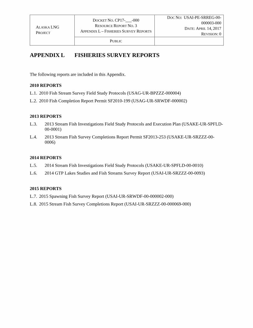
appendix l fisherie s survey...
TRANSCRIPT
ALASKA LNG
PROJECT
DOCKET NO. CP17-___-000 RESOURCE REPORT NO. 3
APPENDIX L – FISHERIES SURVEY REPORTS
DOC NO: USAI-PE-SRREG-00-000003-000
DATE: APRIL 14, 2017
REVISION: 0
PUBLIC
APPENDIX L FISHERIES SURVEY REPORTS The following reports are included in this Appendix. 2010 REPORTS
L.1. 2010 Fish Stream Survey Field Study Protocols (USAG-UR-BPZZZ-000004)
L.2. 2010 Fish Completion Report Permit SF2010-199 (USAG-UR-SRWDF-000002)
2013 REPORTS
L.3. 2013 Stream Fish Investigations Field Study Protocols and Execution Plan (USAKE-UR-SPFLD-00-0001)
L.4. 2013 Stream Fish Survey Completions Report Permit SF2013-253 (USAKE-UR-SRZZZ-00-0006)
2014 REPORTS
L.5. 2014 Stream Fish Investigations Field Study Protocols (USAKE-UR-SPFLD-00-0010)
L.6. 2014 GTP Lakes Studies and Fish Streams Survey Report (USAI-UR-SRZZZ-00-0093)
2015 REPORTS
L.7. 2015 Spawning Fish Survey Report (USAI-UR-SRWDF-00-000002-000)
L.8. 2015 Stream Fish Survey Completions Report (USAI-UR-SRZZZ-00-000069-000)

ALASKA LNG PROJECT
DOCKET NO. CP17-___-000 RESOURCE REPORT NO. 3
APPENDIX L PART 1 OF 10
DOC NO: USAKE-PT-SRREG-00-000006-000
APRIL 14, 2017 REVISION: 0
PUBLIC
Part 1 of 10 of Appendix L of Resource Report No. 3

ALASKA LNG
PROJECT
DOCKET NO. CP17-___-000 RESOURCE REPORT NO. 3
APPENDIX L –FISHERIES SURVEY REPORTS
DOC NO: USAI-PE-SRREG-00-000003-000
DATE: APRIL 14, 2017
REVISION: 0
PUBLIC
APPENDIX L.1 2010 FISH STREAM SURVEY FIELD STUDY PROTOCOLS (USAG-UR-BPZZZ-000004)

2010 Fish Stream Survey Field Study Protocols USAG-UR-BPZZZ-000004
Rev Rev date Description Prepared
By Checked
By Endorsed
By Approved
By
A 5.19.2010 Issued for Review and Comment SS DEE KDO
0 6.3.2010 Issued for Use SS DEE KDO
ALASKA 2010 FISH STREAMSURVEY USAG-UR-8PZZZ-000004
FIELD STUDY PROTOCOLSJUNE 2010
PipelineProject REVISION0
APP PROPRIETARY PAGEl
Authorization Page
PREPAREDBV';&:'to,.,J £..<'Lk'1l ~GA~ ,fo-r -;/0Stewart Seaberg
Environmental & Regulatory Support Services, Physical/Biological Studies Lead
CHECKED BY: _ DATE: __ ....:::5;:".:/1'-"'6:...:/1..::.0 _
Dave Erikson
Environmental & Regulatory Support Services, Physical/Biological Studies Manager - WorkPackage 2
ENDORSEDBV:~)~
Kathleen O'Connell
Environmental & Regulatory Support Services Program Manager
APPROVED BY: _ DATE: _
Myron Fedak
Alaska Pipeline Project, U.S. Manager - Environment, Regulatory and Land

2010 FISH STREAM SURVEY
FIELD STUDY PROTOCOLS
USAG-UR-BPZZZ-000004JUNE 2010REVISION 0
APP PROPRIETARY PAGE II
REVISION MODIFICATION LOG
Revision Section Description

2010 FISH STREAM SURVEY
FIELD STUDY PROTOCOLS
USAG-UR-BPZZZ-000004JUNE 2010REVISION 0
APP PROPRIETARY PAGE III
TABLE OF CONTENTS
1.0 INTRODUCTION ............................................................................................................... 1
2.0 OBJECTIVES .................................................................................................................... 2
3.0 METHODS ........................................................................................................................ 3
3.1 FISH SAMPLING ............................................................................................................... 4
3.1.1 Electrofishing ......................................................................................................... 4
3.1.2 Minnow Trapping ................................................................................................... 4
3.1.3 Seining ................................................................................................................... 5
3.1.4 Fyke Nets .............................................................................................................. 5
3.1.5 Angling ................................................................................................................... 5
3.1.6 Visual Observation ................................................................................................ 6
3.2 DATA COLLECTION AND RECORDING ......................................................................... 6
4.0 REPORTING ..................................................................................................................... 8
5.0 LOGISTICS AND SCHEDULE .......................................................................................... 9
6.0 FIELD SAFETY ............................................................................................................... 10
7.0 REFERENCES ................................................................................................................ 11
FIGURE 1: STUDY CORRIDOR ............................................................................................................... 12
ATTACHMENTS Attachment A: Field Survey Form Attachment B: Electrofishing Protocols Attachment C: ADF&G Policies and Requirements Attachment D: Calibration Procedures for YSI Model 556

2010 FISH STREAM SURVEY
FIELD STUDY PROTOCOLS
USAG-UR-BPZZZ-000004JUNE 2010REVISION 0
APP PROPRIETARY PAGE IV
ACRONYMS AND ABBREVIATIONS
ADF&G Alaska Department of Fish and Game
AED automatic external defibrillator
AGPPT Alaska Gas Producers Pipeline Team
BLM Bureau of Land Management
EFH Essential Fish Habitat
EMAP Environmental Mobil Application Program
EPA Environmental Protection Agency
ERSS Environmental & Regulatory Support Services
FERC Federal Energy Regulatory Commission
FL Fork Length
GPS Global Positioning System
μS/cm microSiemens per centimeter
mm Millimeter
NEPA National Environmental Policy Act
ORP oxidation reduction potential
TAPS Trans Alaska Pipeline System
USFWS U.S. Fish and Wildlife Service
YSI Yellow Spring Instruments
2010 FISH STREAM SURVEY
FIELD STUDY PROTOCOLS
USAG-UR-BPZZZ-000004JUNE 2010REVISION 0
APP PROPRIETARY Page 1 of 14
1.0 INTRODUCTION
The Environmental & Regulatory Support Services (ERSS) for the Alaska portion of the Alaska Pipeline Project is proposing to conduct field surveys for fish and fish habitat at streams and rivers crossed by the proposed alignment. The Alaska portion of the pipeline route extends from Point Thomson west to Prudhoe Bay, from Prudhoe Bay south to Fairbanks along the Dalton Highway and Trans Alaska Pipeline System (TAPS), along the Richardson Highway from Fairbanks to Delta Junction, and along the Alaska Highway from Delta Junction to the U.S./Canada Border (Figure 1). The route crosses approximately 430 streams and rivers. The Valdez Option would travel along the same alignment from Point Thomson to Prudhoe Bay, and Prudhoe Bay to Delta Junction, but would be routed south to Valdez at Delta Junction. The Valdez Option crosses a total of approximately 470 streams and rivers.

2010 FISH STREAM SURVEY
FIELD STUDY PROTOCOLS
USAG-UR-BPZZZ-000004JUNE 2010REVISION 0
APP PROPRIETARY Page 2 of 14
2.0 OBJECTIVES
The primary objective of the 2010 Alaska Pipeline Project stream surveys is to identify all resident and anadromous fish streams crossed by the Alberta Option of Alaska Pipeline Project alignment between the North Slope and Delta Junction, Alaska. The identification of resident and anadromous fish streams is required to determine Alaska Department of Fish and Game (ADF&G) regulatory authority under Alaska Statute 16.05.841 and 871, the Federal Energy Regulatory Commission (FERC) Resource Report No. 3, and the Essential Fish Habitat (EFH) Assessment provisions of the Sustainable Fisheries Act. The results of this field survey will also be used to evaluate project-related impacts under the National Environmental Policy Act (NEPA) and other permits including the U.S. Army Corp of Engineers, Section 404 of the Clean Water Act and Section 10 of the Rivers and Harbors Act.
Secondary objectives of the stream surveys are to:
identify specific stream crossing sites with critical fish habitat (spawning and high value rearing habitat);
identify time periods when fishery resources are most sensitive to stream crossing related disturbances;
collect water quality parameters important to fish; and,
describe streambed and stream channel morphology at each surveyed crossing site.
The data collected during the stream surveys will also assist in developing recommendations for alignment adjustments to avoid critical fish habitat and be used to develop stream crossing mitigation measures for specific stream crossing sites.
Results from the 2010 Alaska Pipeline Project stream survey data, along with the stream hydrology data, will be provided to the ADF&G, other fisheries agencies, FERC to assist in developing objectives and sampling strategies used in formulating the 2011 Alaska Pipeline Project stream surveys protocols.

2010 FISH STREAM SURVEY
FIELD STUDY PROTOCOLS
USAG-UR-BPZZZ-000004JUNE 2010REVISION 0
APP PROPRIETARY Page 3 of 14
3.0 METHODS
Prior to conducting field work, an extensive literature search will be conducted to compile all existing fisheries data for each stream crossed by the Alaska Pipeline Project alignment. Data sources include the Alaska Gas Producers Pipeline Team - Fish Stream Survey Report (Alaska Gas Producers Pipeline Team [AGPPT] unpublished), TAPS fish stream data (Bureau of Land Management [BLM] 2002), Alaska Natural Gas Transportation System reports (Craig 1980, Elliott 1982), ADF&G fish surveys (Winters and Morris 2004) and miscellaneous reports from the U.S. Fish and Wildlife Service (USFWS) (Brown 2006) and ADF&G. The results of this literature search, as well as interview with local ADF&G Fisheries Biologists, will identify potential stream crossings requiring additional fish sampling during the 2010 field season. The stream crossing surveys will be prioritized for the 2010 field season to account for access, logistical, and timing constraints. Where possible the stream survey crews will coordinate activities with the Alaska Pipeline Project hydrology crews, and other field crews to maximize survey efficiencies by sharing helicopters and sharing field data.
Stream surveys will be conducted by field crews consisting of a crew leader and two or three experienced field biologists. Field crew leaders will be individuals that have demonstrated the ability to work safely, and efficiently, on Alaska fisheries surveys. All field crew members will meet ADF&G training criteria and will comply with all fish collection permit and all safety requirements.
Field crews will access stream crossing sites by existing highways and secondary roads where possible. A helicopter may be required to access stream crossings sites where the alignment diverges from the existing road system and vehicular access or access on foot is not practical.
At all surveyed crossing sites, each field team will sample fish, record habitat characteristics and measure water quality parameters at the proposed pipeline crossing site (Attachment A). It is expected that each stream crossing site can be sampled in less than two hours. The number of crossing sites sampled per day will vary depending on distance between sites, distance of sampling site from access points, the size of the stream sampled and the sampling technique employed.
A Global Positioning System (GPS) will be used to field locate each stream crossing location and to document sampling locations (Attachment A). The GPS data entry protocol will commit to one standard format (i.e. NAD 83) to ensure the consistency and completeness of data collection at each stream crossing location.
Immediately after arriving at the stream crossing site, an initial assessment of the stream reach will be conducted. This initial assessment will include an attempt to observe adult and juvenile fish with the aid of polarized sunglasses. Field crews will photograph each stream crossing location from both banks as well as views of the reach stream upstream and downstream of the crossing site.
After the initial assessment of the proposed stream crossing location is completed, a sampling strategy will be developed specific to the site. The sampling strategy will consider water depth, water velocity, substrate composition, and other factors to ensure fish sampling
2010 FISH STREAM SURVEY
FIELD STUDY PROTOCOLS
USAG-UR-BPZZZ-000004JUNE 2010REVISION 0
APP PROPRIETARY Page 4 of 14
is conducted safely and efficiently. The sampling effort at each stream crossing will be determined by the crew leader.
3.1 FISH SAMPLING The goal of the fish sampling strategy is to ensure adequate effort is made, and appropriate sampling techniques are used, to capture fish species inhabiting the area. The following fish sampling techniques will be used to accomplish this goal.
3.1.1 Electrofishing
Electrofishing will likely be the preferred method of field sampling in most wadeable streams. Electrofishing has been determined to be the most efficient single method for fish sampling within a stream reach (Environmental Protection Agency [EPA] 2008). In streams with low conductivity (microsiemens per centimeter [μS/cm]), such as those on the North Slope, alternative sampling techniques may be required to optimize sampling efficiencies.
Electrofishing will target juvenile fish and will not be conducted in areas where adult fish are observed. Electrofishing will be conducted along a stream sampling reach equal to approximately 20 times the mean channel width, or roughly one meander length (Fitzpatrick et al. 1998). To ensure sampling efficiency, crews will sample a maximum of 100 meters (330 feet). Crews will attempt to include at least two examples each of two different habitat types (riffles, pools, and runs) in the sample reach.
Field crews will collect fish using a battery powered Smith-Root Backpack Electrofisher (Model LR20B), a small dip net, and a bucket for holding the fish after capture. Electrofishing will begin at the downstream end of the sampling stream reach and work upstream. Electrofishing effort will be conducted using protocol implemented by ADF&G (Buckwalter et al. 2009) (Attachment B). Electrofishing will be conducted from bank to bank to ensure all channel and habitat types are sampled. Crews will avoid herding fish by electrofishing intermittently. After a continuous 5-10 second electrofishing pulse, crews will advance upstream before continuing to electrofish. This sampling strategy will continue for no more than 30 minutes total sampling time, with a cumulative electrofishing total of no less than 300 seconds (button time) per reach. All captured fish will be dipped from the water as soon as possible and placed into a bucket to minimize exposure to the electrical field.
At each sampling location, electrofishing will be immediately stopped if:
rainbow trout are observed or captured;
adult salmon, grayling, burbot or whitefish are observed or captured;
large numbers (greater than 40) of juvenile fish have been captured;
stunned fish fail to recover quickly in the holding bucket.
Electrofishing will not be used in large, non-wadeable streams and rivers.
3.1.2 Minnow Trapping
Field crews will use minnow traps for sampling fish in a variety of habitats. The use of minnow traps is a common and effective sampling method for both juvenile fish and smaller fish species. Minnow traps will be baited, in accordance with ADF&G requirements, with

2010 FISH STREAM SURVEY
FIELD STUDY PROTOCOLS
USAG-UR-BPZZZ-000004JUNE 2010REVISION 0
APP PROPRIETARY Page 5 of 14
cured salmon roe or salmon roe treated with betadine. Minnow traps will be placed in various stream habitats to target a broad range of fish species. Minnow traps will be placed from the stream bank and generally remain in the water for several hours or possibly overnight. Minnow traps will be pulled from the site at the end of the sampling period. Parameters recorded include the total time set, type of habitat, and species and numbers captured.
Each deployed minnow trap will be secured to a fixed object, such as a branch or shrub, to insure the minnow trap is not lost. All minnow traps will be labeled, in accordance with ADF&G requirements (Attachment C) and removed upon completion of sampling.
3.1.3 Seining
Seining is a common method for sampling fish communities in slow moving streams and pool habitats. Seines will consist of ¼ inch mesh nets that trap fish by enclosing or encircling them. The bottom of the seine net has a lead line to keep the net on the bed of the stream, while the top of the net has a float line or floats to keep the seine at the water surface. The fish captured while seining are dip netted from the seine and transferred to a collection bucket for processing.
Beach seining protocols will be variable and based on the judgment of the Field Crew Leader. This method is expected to be conducted infrequently and only in slow moving streams and in pool habitats. Beach seining effort will be limited to survey locations where other sampling protocols are relatively inefficient. Seining protocols generally require one person to drag the net though the water in a circular fashion while the other persons holds the net on shore. Fish caught in the net are dipped out, identified to species, measured and released. The time spent seining, percent of reach sampled, and the total area of the stream sampled by the net is recorded for each set along with stream habitat parameters.
3.1.4 Fyke Nets
Fyke nets may be used at location where other sampling techniques have been ineffective. Fyke nets may be placed across slow moving streams to capture fish moving through the sampling reach overnight. They are generally placed so the wings of the net steer upstream migrating fish into a collection area. Fyke nets are expected to be used sparingly but may be effective on the slow moving streams of the North Slope where alternative sampling techniques are unsuccessful. Methods used at a specific site will be determined by the Field Crew leader. Typically, fyke nets are set with one wing on shore and the other staked a short distance offshore. Sampling effort is recorded as the amount of time the net is set. The species caught, size and number are recorded for each set. Care must be taken if wildlife are caught in the net, such as loons, otters or beavers. Human safety is of utmost importance in freeing any captured wildlife.
3.1.5 Angling
Angling, or hook and line sampling, may be conducted on larger streams where other techniques are not practical and will be limited to survey locations where other sampling protocol do not apply. This sampling method could be used in rainbow trout streams where electrofishing is not permitted, water depth or where currents would make it hazardous to
2010 FISH STREAM SURVEY
FIELD STUDY PROTOCOLS
USAG-UR-BPZZZ-000004JUNE 2010REVISION 0
APP PROPRIETARY Page 6 of 14
seine, or stream banks too steep for placement of minnow traps. Protocols require recording the length of time angling, bait used, species captured, and size of each fish. Angling will not occur if local resident are present to eliminate any misperceptions of sport fishing.
3.1.6 Visual Observation
Some of the larger currently-specified anadromous fish streams may only be surveyed by direct observation. Field crews will assess these specified anadromous stream crossing sites during the course of the stream surveys and in consultation with ADF&G. Observations at these crossings will be to identify salmon spawning habitat within and adjacent to the proposed crossing locations. These observations may also provide details on run timing and could be helpful in future development of stream crossing mitigation measures. To the extent possible, the presence of anadromous fish spawning and high-value rearing habitat will be noted. Specific mitigation measures for the pipeline crossing may be developed as a result of the habitat and sensitivity evaluation.
3.2 DATA COLLECTION AND RECORDING Regardless of the sampling techniques used to capture fish, all fish will be removed from the water as quickly as possible and held in a bucket for processing. All captured fish will be positively identified to species and measured to the nearest millimeter (mm) fork length (FL). Color fish guides will be used to help identify fish species in the field. Representative photos of common fish will be taken. Photo will also be taken of individual fish that can’t be positively identified. These photos will be sent to recognized experts for confirmation of identification. Fish will be released alive near the point of capture. Some mortalities may be kept for confirmation of identification.
In addition to fish sampling, baseline water quality data and stream flow data will be collected at each stream crossing site (Attachment A). Baseline water quality data will be collected to assess habitat conditions. Water quality parameters will include water temperature, pH, dissolved oxygen, conductivity, color, turbidity, oxidation reduction potential (ORP), sheen (oil or organic), and odor. Water quality measurements will be collected in the field with Yellow Spring Instruments (YSI) Model 556 (Attachment D) water quality meters and a YSI turbidity meter Model 2100. The water quality meters will be calibrated on a daily basic. Water quality data will be check for values within expected ranges during the QC process after the data has been downloaded to the sharepoint site. Physical characteristics of the stream or river, such as channel width, depth and water velocity, aquatic habitats, habitat value, and riparian zone, will also be recorded .
All field data collected at each crossing will be recorded on field data forms and then entered into an electronic data form using a Trimble Nomad field computer with a proprietary ESRI ArcPad-based data entry program, Environmental Mobil Application for Pipelines (EMAP). This program associates the GPS location of the stream reach with the electronic data sheet, site photos, sketches and field notes. The field data will be uploaded to a central project website through an internet connection or by a satellite link. A quality check will be preformed and the information will be archived for later analysis.
An annual Fish Study Report will be prepared after the field season which will include all field data collected and summary tables and graphics. Findings of the report will be used as

2010 FISH STREAM SURVEY
FIELD STUDY PROTOCOLS
USAG-UR-BPZZZ-000004JUNE 2010REVISION 0
APP PROPRIETARY Page 7 of 14
the basis for Title 16 Fish Habitat Permit stream crossing permit applications, the EFH Assessment, and FERC Resource Report 3. The report will also include preliminary recommendations for site specific stream crossing mitigation measures and potential alignment adjustments to avoid critical fish habitat.

2010 FISH STREAM SURVEY
FIELD STUDY PROTOCOLS
USAG-UR-BPZZZ-000004JUNE 2010REVISION 0
APP PROPRIETARY Page 8 of 14
4.0 REPORTING
Results of the 2010 stream crossing surveys will be included in a study report after the field season has been completed. Both anadromous and resident fish captured or observed at stream survey sites will be documented. All data collected during the survey will be compiled and included in a comprehensive stream survey report. Digital photographs will be incorporated into the report as appropriate for each stream crossing site.
The Field Crew Leader will contact the ADF&G Area Biologist before sampling occurs in each region to inform local offices of the sample schedule, location and activity. Weekly contact will also be made with the local ADF&G office to report on the past week’s sampling results.
A field data memo on all field survey activities will be developed and submitted to ADF&G at the end of the field season as a condition of the ADF&G Fish Resource Permit for the Project. This report will include numbers and locations of streams sampled, number and size of fish captured by species, and any fish mortality.

2010 FISH STREAM SURVEY
FIELD STUDY PROTOCOLS
USAG-UR-BPZZZ-000004JUNE 2010REVISION 0
APP PROPRIETARY Page 9 of 14
5.0 LOGISTICS AND SCHEDULE
Schedule
Field work for summer 2010 will include:
Early season – two field teams (4 people) for two weeks in June (June 16-30) and four field crews (4 people) for two weeks each in July (July 7 -30).
Late season – four field teams (4 people) for four weeks in August (August 3-31) and one week in September (September 1-8) (depending on weather).
Logistics
The majority of the stream and river crossing locations will be accessed from the Dalton highway, TAPS Access Road, and the Richardson and Alaska Highways. Most of the locations will be within walking distance from a road. For remote areas, (i.e. Point Thomson to Prudhoe Bay), access will be by helicopters.
Teams during the early season will be based out of local commercial lodging. During the late season, crews will be based out of local commercial lodging and out of man camps specifically established for the Alaska Pipeline Project.
The 2010 field season will focus on State and Federal Land. Land ownership will be established before conduction wetlands field work. No work will be done on private or military lands during the 2010 field season.
2010 FISH STREAM SURVEY
FIELD STUDY PROTOCOLS
USAG-UR-BPZZZ-000004JUNE 2010REVISION 0
APP PROPRIETARY Page 10 of 14
6.0 FIELD SAFETY
Because of the inherent risks associated with collecting fisheries data on streams and rivers, several precautions will be instituted. All field personnel will be required to be “fit for duty”, which will require filling out an employee self screening form, drug and alcohol test, and baseline medical exam. All field personnel are also required to attend a two day field safety course “Learn to Return.” This will be followed by a day of project-specific safety training, focusing on the specifics of the individual Field Study Program and the geographic location where the field teams will be working. All field personnel will be required to be familiar with the Field Safety Plan for the project and sign a statement to that effect. In addition, all field personnel participating in electrofishing activity will need to be certified for this activity. The Team Lead for the fisheries crews have to have a minimum of 30 days of electrofishing experience prior to commencing field sampling.
Tailgate meetings will be held at the beginning of each day to discuss the potential hazards and mitigation measures to avoid and/or minimize risks. In addition, proper protective clothing and emergency measure in the field include:
electrician’s protective rubber gloves for insulation from electrical current;
neoprene chest waders will be worn by all field crew members that enter the water;
only wadeable streams will be surveyed with the electrofisher;
field personnel will wear personal floatation device (pfd) when working on steams or rivers with swift currents or deep water; brief safety meeting will be held before entry to any steam with sufficient depth or current to sweep a team member off there feet.
a towel and dry clothes will be available at all times in case someone falls into cold water; and,
an automatic external defibrillator (AED) will be carried by all fish crews during electrofishing activity.
A wildlife safety officer (bear guard) will accompany all field teams during survey activity.

2010 FISH STREAM SURVEY
FIELD STUDY PROTOCOLS
USAG-UR-BPZZZ-000004JUNE 2010REVISION 0
APP PROPRIETARY Page 11 of 14
7.0 REFERENCES
ID Reference
AGPPT unpublished Alaska Gas Producers Pipeline Team. Unpublished. FERC Resource Report 3. Fish, Wildlife and Vegetation. Highway Route.
BLM 2002 U.S. Department of the Interior. Bureau of Land Management (BLM. 2002. Final Environmental Impact Statement - Renewal of the Federal Grant for the Trans-Alaska Pipeline System Right-of-Way. Publication No. BLM/AK/PT-03/005+2880+990.
Brown 2006 Brown, R.J. Life History and Demographic Characteristics of Arctic Cisco, Dolly Varden, and Other Fish Species in the Barter Island Region of Northern Alaska. Alaska Fisheries Technical Report Number 101. U.S. Fish and Wildlife Service. Fairbanks, AK
Buckwalter 2008 Buckwalter, J. 2008. FY 2008 operational plan. Inventory of fish distribution in upper Kuskokwim drainage. ADFG, Anchorage, AK. 102 pp.
Craig 1980 Craig, P. 1980. Fisheries Resources along the Alaska Gas Pipeline Route (Prudhoe Bay to the Yukon Territories) proposed by the Northwest Alaska Pipeline Company, LGL Ecological Research Associates, Fairbanks, AK.
Elliott 1982 Elliott, R. Final Report on the fisheries surveys along Northwest Alaska Pipelne Company’s proposed gas pipeline route (Delta to the Canadian Border. U.S. Fish and Wildlife Service, Anchorage, AK
Fitzpatrick et al. 1998 Fitzpatrick, F.A., I. R. Waite, P. J. D’Arconte, M. R. Meador, M. A. Maupin, and M.E. Gurtz. 1998. Revised Methods for Characterizing Stream Habitat in the National Water-Quality Assessment Program. United States Department of the Interior, Geological Survey. Water-Resources Investigations Report 98-4052, Raleigh, North Carolina.
EPA 2008 Environmental Protection Agency. 2008 New prospectives in electrofishing. Office of Research and Development. Washington, D.C.
Winters and Morris 2004 Winters J.F. and W.A. Morris. 2004. Fisheries Investigations in streams crossed by the proposed Point Thomson Gas Recycling Project. Alaska Department of Natural Resources, Office of Habitat Management and Permitting. Technical Report No. 04-03.

2010 FISH STREAM SURVEY
FIELD STUDY PROTOCOLS
USAG-UR-BPZZZ-000004JUNE 2010REVISION 0
APP PROPRIETARY Page 12 of 14
FIGURE 1: STUDY CORRIDOR

2010 FISH STREAM SURVEY
FIELD STUDY PROTOCOLS
USAG-UR-BPZZZ-000004JUNE 2010REVISION 0
APP PROPRIETARY Page 13 of 14
ATTACHMENT A: FISH STREAM DATA FORMS (EMAP)

FISH SURVEY STREAMS DATA FORM
Page 1 of 2
SITE DESCRIPTION
Survey Type: Centerline___ Access Road (explain)___ Other (explain)______
Date: Project Name & No.: APP ERSS 26220600 Feature Id:
Investigators: Team No.:
State: Alaska Region: Milepost: Quad Name:
Latitude: Longitude: Datum:
Logbook No.: Logbook Page No.: Picture No.:
PHYSICAL/ CHEMICAL ATTRIBUTES
Weather: Cloudy________ Partly Cloudy__________ Mostly Cloudy_____________ Rainy_____________
Precipitation: : None________ Drizzle__________ Rain__________ Showers_____________ Snow_____________
Water Temperature (C): Air Temperature (C): pH: Dissolved Oxygen (mg/l):
Specific Conductivity (µS/cm; σs): Turbidity (NTU): Color:
ORP (mV): Sheen (Y/N): Odor: Other:
Flow Type: : Perennial________ Seasonal__________ Intermittent_____________ Ephemeral_____________
Stream Substrate (%): Silt________ Sand__________ Gravel_____________ Cobble_____________ Rubble________ Boulder__________ Bed Rock_____________ Organics_____________
Aquatic Habitats (check all that apply): Sand Bar________ Gravel Bar________ Mud Bar________ Undercut Banks________ Gravel________ Riffles________ Deep Pools________ Bank root systems________ Overhanging trees/shrubs________ In-stream emergent plants: ________
Riparian Zone (Y/N): Rain__________ If Yes, width of natural vegetation zone from edge of active channel out onto flood plain looking downstream (DS): R___________(m) L (m) Vegetative layers: trees________ shrubs________ Grass________ Herbs
Significant bare areas in riparian zone (Y/N):________
Spawning (Y/N)________ Rearing (Y/N)__________ Anadromous (Y/N)__________
Notes (i.e. spawning fish, presence of redds):
SAMPLING ATTRIBUTES
Start Time: End Time: Electrofishing -Volts (V) : Electrofishing -Current (I or A)
Electrofishing -Power (W) Electrofishing - Frequency (Hz) :
Electrofishing - EF Time (s) : Electrofishing Waveform:
Actual Sampling Reach Length (m) Sampling Efficiency (% of sample reach) Notes:
Sample gear: No. of Traps/sets CPUE:
STREAM PROFILE (cross sectional at crossing)
Please include: Directional & North Arrow, Centerline, Length of feature, Distances from Centerline, Photo Locations, and Survey corridor Angle of Crossing at Centerline: ____________
FISH SURVEY STREAMS DATA FORM
Page 2 of 2
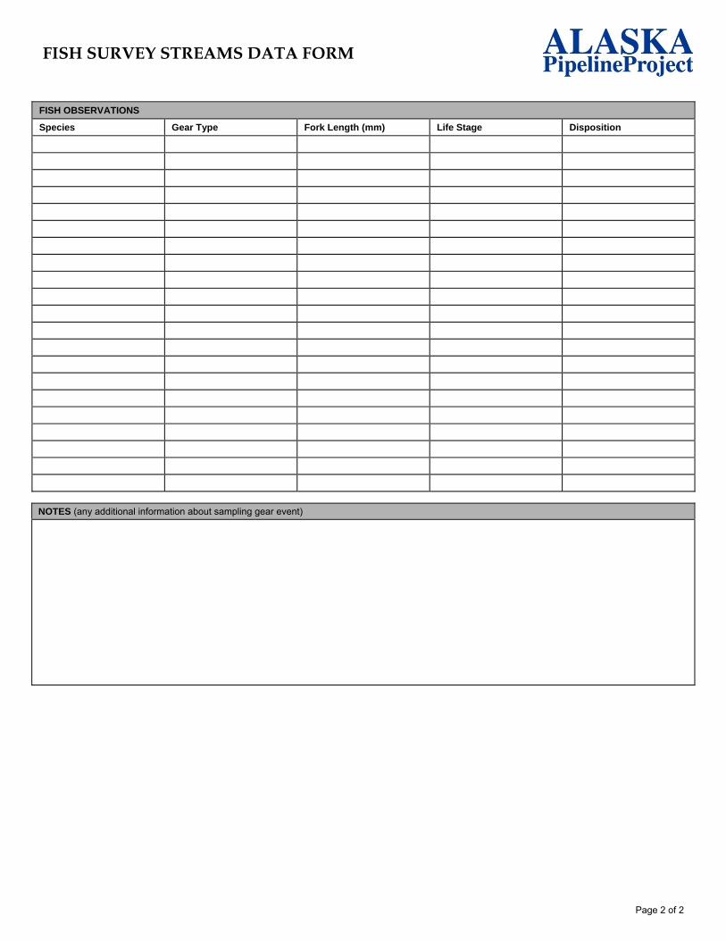
FISH OBSERVATIONS
Species Gear Type Fork Length (mm) Life Stage Disposition
NOTES (any additional information about sampling gear event)

2010 FISH STREAM SURVEY
FIELD STUDY PROTOCOLS
USAG-UR-BPZZZ-000004JUNE 2010REVISION 0
APP PROPRIETARY
ATTACHMENT B: ELECTROFISHING PROTOCOLS

Attachment B
From: Buckwalter, J. 2008. FY 2008 operational plan. Inventory of fish distribution in upper Kuskokwim drainage. ADFG, Anchorage, AK. 102 pp.
(Appendix E1.–Wadeable site electrofishing protocol)
This sampling is intended to collect all but the rarest fish species and life stages in a reach, and their abundances in the collection should be relative to their proportionate abundance in the water body (McCormick and Hughes 1998). The procedure to sample with the backpack electrofisher unit is presented below.
These procedures are designed for the low stream order, anticipated low fish community diversity, and anticipated anadromous fish habitat sampling locations targeted by this project. Procedures may need to be adjusted for higher order streams and/or higher expected fish community diversity.
Note: The Smith-Root LR-24 backpack electrofisher is equipped with an audio alarm that sounds when the output voltage exceeds 30 V. It begins as a strong continuous tone and begins to beep slowly at currents of 1.25 amps. It beeps faster as input current increases. In case of an overload (in excess of 3 amps), the beep becomes very rapid and the overload indicator comes on. Release the anode switch and adjust voltage and continue fishing.
Procedures to collect fish at wadeable sites. (adapted from McCormick and Hughes 1998).
1. At the selected station location, measure channel wetted width (in tenths of meters) in a representative non-pool reach.
2. Enter the measured wetted channel width in the appropriate field on the Aquatic Habitat tab. The Sample Reach Length field will compute and report (meters) the required fish sampling reach. The total reach length is 40 times the measured channel wetted width, except that the reach length shall not be less than 150 m nor greater than 300 m. For reaches being sampled to investigate sampling sufficiency (Objective 3), each of 8-10 individual sample sub-reach lengths will be 10 channel widths.
3. The 2-person electrofishing team shall walk downstream the required total reach length determined in step 2 (40 channel widths). The team shall measure the curvilinear distance of the channel, but shall avoid walking in the channel or otherwise startling fish. A GPS unit (preferred) used in trip odometer mode, a hip chain, or other similarly accurate method, shall be used to measure the reach length.
4. Set the backpack electrofisher to pulsed DC, and adjust electrofisher output settings in the sequence listed below (adapted from Smith-Root's user manual for the LR-24 electrofisher, Rev.04, 2007) in order to achieve the optimal power threshold for successful electrofishing, while minimizing trauma to the fish:
a. Select initial voltage setting according to the ambient water conductivity:

b. Conductivity (μS/cm) Peak Voltage setting (V) > 300 100-300 100-300 300-600 50-100 600-800 < 50 ≥ 800
c. Set pulse frequency to 30 pulses-per-second (pps).
5. Set duty cycle to achieve a pulse width of 4 ms, according to the following table:
Frequency (pps) Duty cycle (%) 30 12 35 14 40 16 45 18 50 20 60 24
6. Ensure that the timer is reset to zero, and begin fishing.
7. If electrofishing is unsuccessful:
a. Increase the voltage by 50 V, press the enter key and try again. Stop increasing voltage when fish exhibit a forced response (twitch).
b. If fish twitch, but are not showing taxis (induced movement of the fish toward the anode), increase the duty cycle by 10%, press the Enter key and try again. If necessary, repeat this step until fish show taxis. If the duty cycle is increased to maximum and taxis is still not achieved, go to the next step.
c. Increase the frequency by 10 pps, and press the Enter key. Adjust the duty cycle to achieve a pulse width of 4 ms for the given frequency setting (see Step c), and try again. If necessary, go back to Step "a" before increasing frequency again. Avoid frequencies >60 pps.
8. Attempt to maximize capture-prone responses (i.e, taxis, forced swimming, or loss of equilibreum) and minimize responses associated with elevated trauma (i.e., immobilization, branding, spinal deformities, or recovery period exceeding 15 seconds). Try to capture fish before they approach near to the electrodes, and remove fish quickly from the electric field.
9. Beginning at the downstream end of the sampling reach, the electrofishing team shall fish in an upstream direction, zigzagging across the channel from bank to bank in order to sample all habitat types. Depress the switch and sweep the anode slowly from side to side in the water. To avoid herding fish, sample a given habitat patch thoroughly, then advance quietly 1–3 m with the switch off before resuming sampling.
Sample available cover (e.g., cut-banks, woody debris) as well as riffles and pools. Move the anode in and out of large snags or deep cuts or release the switch, move the anode away slightly, depress the switch again and sweep the anode away from the cover to draw fish out into open. Be sure that deep, shallow, fast, slow, complex, and

simple habitats are all sampled. In stretches with deep pools, fish the margins of the pool as much as possible, being extremely careful not to step into deep water.
10. The netter follows downstream of the electrofisher operator, collecting fish with a dipnet. Netted fish are deposited in a bucket for later processing. Particularly when visibility is obscured by turbidity, debris, or vegetation, the netter should keep the dip net in the water downstream of the anode. The dip net should be near vertical, in contact with the substrate, with the net opening facing the current. The distance between the anode and the dip net is related to the current velocity: the faster the current the greater the distance between the anode and dip net.
11. Change the water in the bucket periodically to minimize physiological stress prior to measuring fish. Process large fish (> 300 mm) immediately and record species, life stage, life history, length, and external anomalies in a notebook for future transfer to the database. At the completion of electrofishing, upon reaching the upstream terminus of the reach (or sub-reach), report the appropriate information specified on the Fish Sampling Effort tab, then report the individual fish information.

2010 FISH STREAM SURVEY
FIELD STUDY PROTOCOLS
USAG-UR-BPZZZ-000004JUNE 2010REVISION 0
APP PROPRIETARY
ATTACHMENT C: ADF&G POLICIES AND REQUIREMENTS

-----------------------------.,--------------- ~~~-..- ~~
ALASKA DEPARTMENT OF FISH AND GAME
POLICY AND REQUIREMENTS FORFISH RESOURCE PERMITS
GENERAL
The Alaska Department of Fish and Game (ADF&G) is the custodian of the fish resources of thestate. Permits are required for all collections of fish, shellfish, and aquatic plants not covered byexisting regulations. This requirement includes methods and means (gear), numbers, locations,seasons, or the possession and/or transportation of live fish in any life-stage outside of existingsport, personal use, aquatic farm, and commercial regulations. Fish resource permits are aprivilege and will be issued only to those organizations and individuals who meet the departmentalrequirements specified in this policy, and who are engaged in scientific, educational, propagative, orexhibition activities.
The provisions of this policy govern the permits required for collecting, holdinq, and propagatingfish, shellfish, or aquatic plants. They do not apply to the cultivation of ornamental fish.
Possession of a permit issued under this policy does not relieve the permittee of the responsibilityfor securing any other local, state, or federal permits required for the project.
Permits issued under this policy are nontransferable. Falsification of any information on anapplication, affidavit, permit, or report required by the permit or by this POli9Ywill be grounds forpermit revocation or denial of future permit applications.
1

r---------------------------------------------------------------------------- ----
PERMIT REQUIRED
No organization or individual may collect or hold alive any live fish, shellfish, or aquatic plants, ortheir gametes for purposes of science, education, propaqation, or exhibition unless thatorg~nization or individual holds a fish resource permit issued by the commissioner. Unlessotherwise specified or revoked, a permit shall expire no later than December 31 of the year in whichit was issued.A fish resource permit authorizes only the activities specified in the permit. Any change in thepermit or terms of the permit requires an amendment to the permit.
UNIFORM APPLICATION PROCEDURES
Each applicant for a fish resource permit shall submit the following information to the department ona form approved by the commissioner:
(1) The name ofthe applicant and the name of the primary employer, or instructor, sponsor orcontractor of the study.
(2) A written operational plan that identifies the purpose and the need forthe desired collection,research objectives, procedures, and an explanation of benefits that may accrue from therequested activities.
(3) Dates and specific locations where collections are to be made.
(4) Specific numbers of specimens, by species and life stage, required to meet the objectives ofthe project, including both common and scientific names.
(5) Plans for final disposition, manner of disposition, and anticipated date when disposition ofspecimens will occur.
(6) Specific methods and/or gear to be used in the collection of specimens.
(7) The names of all persons, in addition to the applicant or chief investigator, who will beparticipating in field activities; or the number of people expected to participate with anagreement to furnish the names when they are identified.
A completed application must be submitted to the department headquarters office at P.O. Box25526, Juneau, AK 99802 as follows:
(1) applications for capture, collection, and holding of fish and aquatic plants for non-propagative purposes from freshwater are to be sent to the attention of the Division of SportFish;
(2) applications for capture, collection, and holding of fish and aquatic plants for non-propagative purposes from saltwater are to be sent to the attention of the CommercialFisheries Management and Development Division;
(3) applications for finfish propagation are to be sent to the attention of the CommercialFisheries Management and Development Division;
2

(4) applications for activities related to shellfish and aquatic plant propagation, and shellfish andaquatic plant farm and hatchery operations are to be sent to the attention of the MaricultureCoordinator, Commercial Fisheries Management and Development Division.
If the commissioner determines that an application is incomplete and that further information isnecessary, the department will return the application to the applicant with a description of thedeficient information.
PERMIT CLASSIFICATIONS
The commissioner may issue a fish resource permit for the following activities:
I. Collection: Applicants must be involved in legitimate research or educational activities.Permit applications are reviewed and processed by the Commercial Fisheries Managementand Development Division (salt water) and the Sport Fish Division (fresh water) to collectspecimens offish, shellfish and aquatic plants from salt and freshwater. The specimens willbe killed at the collection site, or caught and released unharmed at the collection site.
The reasons for capturing and/or collecting fish are diverse; however, most requests forscientific collections stem from a need to: (1) properly conduct impact analysis fromproposed activities; (2) manipulate aquatic habitat features for improving fish productivity;and/or (3) obtain fish resource data that will support legitimate academic inquires(research). Moreover, the capture, collection, and disposition of fish, if done in the propermanner, can have considerable educational value. Examples of educational uses includethe preparation of voucher specimens of fish from a specific location, fish dissection, fieldecology investigations, and aquatic education programs.
II. Holding: Applicants must be involved in legitimate research or educational activities.Permit applications are reviewed and processed by Commercial Fisheries Management andDevelopment Division (salt water) and Division of Sport Fish (fresh water) to allowindividuals or organizations to exhibit live saltwater or fresh water specimens, to export livespecimens from the state, or for non-propagative research that requires maintaining livespecimens for some amount of time after capture. Exportation of live specimens fromAlaska requires an importation permit issued by the appropriate resource agency of theimporting state or country.
A permit in this category will allow the transport and live holding of specimens to becontained in aquaria. Specimens are not to be released. The permit number must bedisplayed on the aquaria. This permit will fulfill the requirements of 5 AAC 41, fortransportation and possession of live fish. Carcasses must be disposed in a mannerapproved by the department. All aquarium systems (open and closed) may be inspectedand will require approval by an ADF&G Fish Health Services Pathologist.
III. Propagation: Permit applications are reviewed and processed by the Commercial FisheriesManagement and Development Division (all species) for educational, vocational, research,or site suitability purposes. Applications will also be reviewed by the Sport Fish Division.Applicants must be involved in legitimate activities for a scientific, educational, oraquaculture organization. If the applicant is an Alaska public school, the school will be
3

~-------------- ------------------------------------------~-----------------------
considered the primary employer, not the school district, and the classroom instructor whohas daily supervision will be considered the applicant.
A. Mariculture site suitability. Approval by an ADF&G Fish Health Services Pathologist isrequired. The permit will fulfill fish transport permit (FTP) requirements as specifiedunder 5 AAC 41.
1. Limited to one year, no renewal;2. Limited to 10,000 organisms with no release;3. No commercial use;4. Does not establish any proprietary interest in the site.
B. Scientific/Educational. This permit will serve to transport and hold alive species andwill fulfill FTP requirements as specified under 5 AAC 41. Approval by an ADF&G FishHealth Services Pathologist may be required: Only wild coho, pink, and chum salmonor any species obtained from a hatchery in the state (other than sockeye salmon) willbe allowed for classroom projects. In this category, the following conditions apply:
1. No releases (of fish or effluent into waters of the state).
(a) Less than or equal to 500 eggs or one spawning pair;(b) Wild stock or hatchery eggs;(c) Shellfish and aquatic plant projects related to aquatic farming.
2. Small number releases
(a) Progeny from less than or equal to 500 eggs or one spawning pair;(b) Fish release only at place of origin or in a departmentally approved
landlocked lake; effluent release either disinfected or discharged into asewage treatment facility;
(c) Cumulative impacts from multiple projects in an area or drainage will becarefully assessed;
(d) The project must be for educational purposes only and any adult returnsfrom the project may not be claimed as exclusive property of the project.The returns are considered common property and no special harvestrights may be claimed for cost recovery or any other reason;
(e) Release must be timed as nearly as possible to the natural timing of thedonor stock, the plankton bloom, or at a time appropriate to maximize thesurvival.
3. If an event occurs that results in substantial egg mortalities, a report is required toexplain the nature of the incident, the cause of the incident, the date of theincident, and any corrective action taken. This report must be received in theheadquarters office before any further live fish or egg transport is made. Theclassroom may be allowed one additional transport of less than or equal to 500eggs or one spawning pair from the original source.
C. Vocational. Up to 50,000 eggs or equivalent in spawning pairs (sockeye salmonshould not be used).
1. Inspection by an ADF&G Fish Health Services Pathologist and genetic samplingmay be required, and additional restrictions may be required for fisheriesmanagement and conservation needs;
2. Regional planning team (RPT) review at a regularly scheduled meeting isrequired. Based on the recommendation of the RPT, additional restrictions maybe required for fisheries management and conservation needs, and cumulativeimpacts from multiple projects in an area or drainage may be carefully assessed;
3. If an RPT does not exist for the area, the department's two fisheries divisions willformally review the application. As part of the review, public comment will besolicited through a newspaper advertisement paid for by applicant. The public willbe invited to submit written comment for a 3D-day period to the CommercialFisheries Management and Development Division Juneau headquarters office;
4. An FTP for brood stock selection is required.
5. The project must be for educational purposes only and any adult returns from thisproject may not be claimed as exclusive property of the project. The returns areconsidered common property and no special harvest rights may be claimed forcost recovery or any other reason.
D. Propagative. Eggs in the amounts intended to result in less than or equal to 5,000returning adults. No more than 500,000 eggs of non-smelt species (e.g. pink or chumsalmon) or 100,000 eggs of smolt species (e.g. coho, sockeye, or chinook) or theequivalent in spawning pairs may be used.
1. Research and Bioenhancement. Accredited institutions of higher learning andcooperative governmental projects.
(a) Inspection by an ADF&G Fish Health Services Pathologist and geneticsampling may be required;
(b) Facility plans/diagrams and water source information must be furnished;(c) An FTP for brood stock selection is required, -
2. Site Suitability. This permit may be issued for two consecutive years. It leads intothe application process for a private nonprofit (PNP) hatchery permit.
(a) Inspection by an ADF&G Fish Health Services Pathologist and geneticsampling may be required;
(b) Facility plans/diaqrams and water source information must be furnished;(c) A management feasibility analysis is required;(d) RPT review at a regularly scheduled meeting is required. Based on the
recommendation of the RPT, additional restrictions may be added forfisheries management and conservation needs;
(e) If an RPT or fisheries management plan does not exist for the area, thedepartment's two fisheries divisions will formally review the application.As part of the review, public comment will be solicited through a
5

newspaper advertisement paid for by applicant. The public will be invitedto submit written comment for a 30-day period to the CommercialFisheries Management and Development Division Juneau headquartersoffice;
(f) An FTP for brood stock selection is required;(g) Release must be timed as nearly as possible to the natural timing of the
donor stock, plankton bloom, or at a time appropriate to maximize thesurvival;
(h) If an event occurs that results in substantial egg mortalities, a report isrequired to explain the nature of the incident, the cause of the incident,the date of the incident, and any corrective action taken. This report mustbe received in the headquarters office before any further live fish or eggtransport is made;
(i) Any adult returns from the project may not be claimed as exclusiveproperty of the project. All returns are considered common property andno special harvest rights may be claimed for cost recovery or any otherreason.
3. Incubation of more than the number of eggs in category D.2, above, requires aPNP hatchery permit (regulated under 5 AAC 40).
PERMIT ISSUANCE, DENIAL, OR REVOCATION
The commissioner will approve, condition, or deny a permit within 30 days after a completeapplication containing all of the applicable information listed in this section has been received in theheadquarters office of the respective division. However, this time frame does not apply to shellfishand aquatic plant farm or vocational activities, which are addressed as follows:
(1) the commissioner shall approve, condition, or deny a mariculture site suitability permitapplication or a fish resource permit related to aquatic farming within five days after adetermination of project consistency with the Alaska Coastal Management Program hasbeen determined under 6 AAC 50.
(2) the commissioner shall approve, condition, or deny a vocational/research propagationapplication within 10 days after the review by the appropriate RPT, if that review isnecessary.
(3) the commissioner may extend the review period for complex or large projects.
The commissioner will deny a fish resource permit if it is determined that the proposed activities willadversely affect the continued health and perpetuation of native, wild, or propagated stocks offish,shellfish, aquatic plants, or their habitat. The commissioner will also deny a fish resource permit ifthe proposed activities will adversely disrupt traditional common property fisheries.
The commissioner will deny a fish resource permit or permit amendment ifthe applicant's proposedstudy plan specifications are inadequate. This-decision will be based on the study plan's purpose,need, procedures, research or educational objectives; or other specifications that do not adequately
6
address the issues of disease, genetics, competition, predation, or perpetuation of native, wild, orpropagated fish stocks; or on specifications that are deemed inadequate because of the lack ofother information required in this policy.
Approval of a continuing or multi-year fish resource project, such as a classroom incubation orresearch project, will be based upon past performance.
Written notice of denial will be given to the applicant, including the reasons for denial.
The commissioner will revoke a fish resource permit or particular provisions of that permit, includingamendments, if he or she finds:
(1) on the basis of new information or changed circumstances that the permitted activity willadversely affect the continued health or perpetuation of native, wild, or propagated stocks ofgame, fish, shellfish, aquatic plants or their habitat; or
(2) the permittee fails to comply with terms and conditions of the permit, or the provisions of thispolicy.
An application for a fish resource permit that has been denied or a permit that has been revoked bythe commissioner will, in the commissioner's discretion, be reconsidered if the applicant providesnew or additional written information that may have altered the original decision.
AMENDMENTS TO THE PERMIT
A permittee may request an amendment to a fish resource permit by writing to the department'sheadquarters office. The permittee must submit an amended plan, and a written explanation of whythe amendment is being requested. The commissioner may approve or deny an amendment to thepermit. The commissioner may alter, amend, or revoke a permit if additional information orchanged circumstances affect the adequacy of its terms and conditions.
Amendments become effective on approval by the commissioner, receipt of the amendment by thepermittee, or at a later date specified in the amendment. Unless otherwise specified, amendmentsremain valid for the duration of the permit and must be attached to the original permit.
PERMIT CONDITIONS
The commissioner may prescribe conditions in a permit to control or prevent the occurrence ofdisease, genetic change, or other disturbances of a biological nature that may affect native, wild, orpropagated fish, shellfish or aquatic plants. The commissioner may prescribe conditions in a permitto minimize disturbances or alterations to traditional fisheries or other uses of fish and wildliferesources. These conditions may include limitations Onthe number of a stock or a species to betaken, release locations, methods of transport or release, quarantine, effluent control, diseaseinspection, or other measures, such as the requirement for an FTP, as specified under 5 AAC 41,that are necessary to achieve the purposes of this policy.
The commissioner may prescribe special permit requirements, depending upon the complexity ofthe overall project for which the specific application is being made. Each project component will beevaluated independently and modified as appropriate.
7
RETENTION OF PERMIT FOR INSPECTION
A copy of the permit, including any amendments, must be retained by the permittee and madeavailable for inspection upon request by a representative of the department or a law enforcementofficer. The permit or a copy of the permit must be available at all field collection sites and at theproject site.
Each permittee must give authorized representatives of the department and law enforcementofficers free and unobstructed access at all times to permit sites. Each permittee must give suchassistance and furnish information that the representative or law enforcement officer mayreasonably require for monitoring and inspection purposes.
REPORTING
A collection report is required and must be submitted to the divisional headquarters office thatissued the permit within 30 days after the expiration date of the permit, unless an earlier date isspecified. The report shall include: numbers of each species collected, date and place taken,disposition of the specimens, and, if applicable, sex, life stage, age, lengths and weights of fish, orany other information required in the permit.
A completion report detailing the results and findings of any data analysis for the project, if notsubmitted with the collection report described above, must be submitted to the department withinsix months of the expiration of the permit. Data from such reports are considered publicinformation.
The commissioner will not re-issue a permit to the permittee or agency until the above reportingrequirements are met.
DELEGATION OF AUTHORITY
No authorities or activities granted under terms of a fish resource permit may be delegated by thepermittee to another person. Permits to agencies will be made to the highest practical level orindividual in each agency. Additional personnel may engage in approved collection activities onlyafter written notification by the permittee and approval by the department. If the applicant is anAlaskan public school, the school will be considered the primary employer, not the school district,and the classroom instructor who has daily supervision will be considered the applicant.RESTRICTIONS
(a) Collected fish, shellfish, or aquatic plant specimens may not be SOld,bartered, or usedas food, and may be used only for the purposes specified in the permit.
(b) If species to be taken or possessed are those under primary jurisdiction of the federalgovernment, the applicant must first obtain a federal permit and submit a copy of it alonqwith the application when applying for the state permit. The state permit may be morerestrictive, but not more liberal than the federal permit.
8

(c) The permittee is responsible for securing any other required state or local permits. Thefish resource permit will not be valid without all other permits required by local, state, andfederal agencies.
(d) Permits will indicate the number of specimens that may be taken, by species and lifestage. Sampling or collecting activities must stop when the maximum allowable numberof specimens is obtained. All live fish, shellfish, and aquatic plants collected in excess ofthe number specified on the permit must be released immediately and unharmed at thecapture location, unless otherwise specified in the permit.
(e) All fish traps, nets or similar capture devices must be labeled with the collector's nameand permit number. A valid sport fishing license must be in the possession of eachperson collecting fish with a hook and line or clams with a shovel.
(f) Use of explosives or chemicals, especially poisons other than chemical baits or lures forcollecting purposes is prohibited. Any chemical anesthetics used must be approved forhuman consumption by the Food and Drug Administration if fish treated with suchchemicals are susceptible to human consumption within 14 days after exposure.
(g) Department staff identified in the permit must be notified before collections or sampling.
(h) Marking or tagging of fish is closely regulated by the state and must not conflict withother programs. Specific approval is required for any marking or tagging project. Thenumber of each species to be marked and the location and type of mark or tag to beused must be specified.
(i) A Title 16 permit may be required from the department's Habitat Division if a weir is to beused to collect fish, or if the proposed activities include stream alteration, water diversion,or other activities that may put fish resources at risk in waters that contain anadromousfishes.
0) Use of electroshocking devices will be closely regulated because such devices cancause substantial injury to fish. In general, electroshocking will not be allowed if largerainbow trout or any species of fish in spawning condition are present.
(k) The applicant should recognize that an application for an educational project is foreducational purposes only. Any adult returns from the project may not be claimed asexclusive property of the project. Returning fish are considered common property and nospecial harvest rights may be claimed for cost recovery or any other reason.
DEFINITIONS
Unless the context indicates otherwise, in this policy
(1) "aquatic plants" means a plant indigenous to state water or that is authorized to be importedinto the state under a permit issued by the commissioner;
(2) "barter" means the exchanqe or trade of fish or game, or their parts, taken for subsistenceuses;
9

(3) "commissioner" means the commissioner of the Department of Fish and Game or his or herdelegated representative;
(4) "complete application" means a final application containing required information which hasbeen accepted by the commissioner and which contains a study plan.
(5) "department" means the Alaska Department of Fish and Game.
(6) "fish" means any species of aquatic finfish, invertebrate, or amphibian, in any stage of its lifecycle, found in or introduced into the state, and includes any part of such aquatic finfish,invertebrate, or amphibian as defined in AS 16.05.940;
(7) "fish transport permit (FTP)" means a permit issued under the authority of 5 AAC 41.001-41.100 which has not expired, been suspended, or terminated;
(8) "law enforcement officer" means a person defined in AS 16.05.150.
(9) "legitimate research" means conforming to recognized scientific principles or recognized rulesand standards which will benefit the state or the department;
(10) "management plan" means a written document which explains the harvest and escapementstrategy the department will implement to regulate commercial, sport, and/or subsistencefisheries. The plan may be either a formally adopted Board of Fisheries regulation, anannually revised plan written by ADF&G describing how a specific area's fisheries will bemanaged, or the regional comprehensive salmon plan for the area.
(11) "mark" or "marking and tagging" means all forms of skin alterations, fin clipping or othermutilation, or the insertion of foreign materials in live fish or other procedures that permit lateridentification;
(12) "ornamental fish" means a fish commonly known as a "tropical fish," "aquarium fish," or"goldfish", which was imported, oultured, or sold in the state, customarily for viewing inaquaria or for raising in closed artificial systems, and not used for sport fishing or humanconsumption purposes;
(13) "permittee" means the applicant and holder of the permit who is responsible for the projectand activities;
(14) "propagation" means the breeding and reproduction offish, shellfish, or aquatic plants for thepurpose of achieving scientific, educational, or vocational objectives;
(15) "shellfish" means any species of crustacean or mollusk, in any stage of its' life cycle that isindigenous to state water or that is authorized to be imported into the state under a permitissued by the commissioner;
(16) "transport" means to ship, carry, import, export, receive, or deliver for Shipment,transportation, carriage, or export.
10

APPROVED:
Ii I d--:o "1_Date
r.Kelly Hepler, DirectorSport Fish Division
~ C. 9/r/o'lKevin Duffy, CommissionerAlaska Department of Fish
Date
11

2010 FISH STREAM SURVEY
FIELD STUDY PROTOCOLS
USAG-UR-BPZZZ-000004JUNE 2010REVISION 0
APP PROPRIETARY
ATTACHMENT D: CALIBRATION PROCEDURES FOR YSI MODEL 556
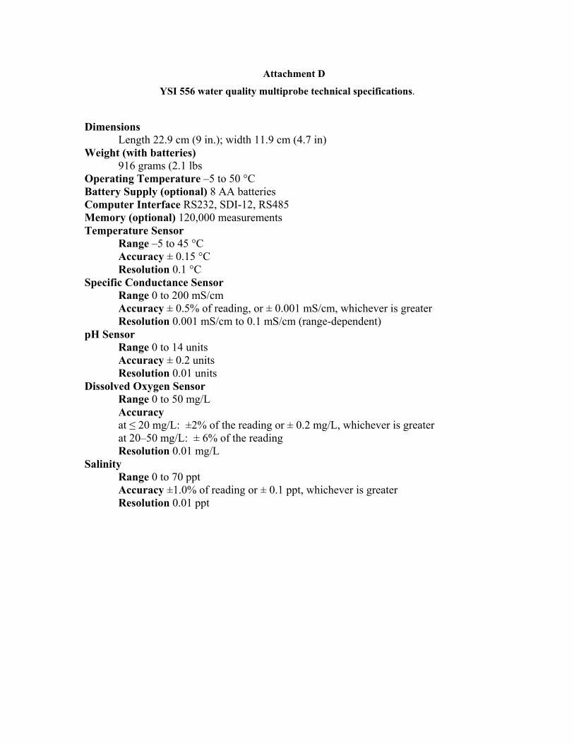
Attachment D
YSI 556 water quality multiprobe technical specifications.
Dimensions Length 22.9 cm (9 in.); width 11.9 cm (4.7 in)
Weight (with batteries) 916 grams (2.1 lbs
Operating Temperature –5 to 50 °C Battery Supply (optional) 8 AA batteries Computer Interface RS232, SDI-12, RS485 Memory (optional) 120,000 measurements Temperature Sensor
Range –5 to 45 °C Accuracy ± 0.15 °C Resolution 0.1 °C
Specific Conductance Sensor Range 0 to 200 mS/cm Accuracy ± 0.5% of reading, or ± 0.001 mS/cm, whichever is greater Resolution 0.001 mS/cm to 0.1 mS/cm (range-dependent)
pH Sensor Range 0 to 14 units Accuracy ± 0.2 units Resolution 0.01 units
Dissolved Oxygen Sensor Range 0 to 50 mg/L Accuracy at ≤ 20 mg/L: ±2% of the reading or ± 0.2 mg/L, whichever is greater at 20–50 mg/L: ± 6% of the reading Resolution 0.01 mg/L
Salinity Range 0 to 70 ppt Accuracy ±1.0% of reading or ± 0.1 ppt, whichever is greater Resolution 0.01 ppt