appendix f – aboriginal heritage survey for the margaret ... river... · appendix f –...
TRANSCRIPT
GHD | Report for Main Roads Western Australia - Margaret River Perimeter Road, 61/27189
Appendix F – Aboriginal Heritage Survey for the Margaret River East Bypass Road

REPORT OF AN ABORIGINAL HERITAGE SURVEY FOR THE MARGARET RIVER EAST BY-PASS ROAD, WESTERN AUSTRALIA
1
A REPORT ON AN ABORIGINAL HERITAGE
SURVEY FOR THE MARGARET RIVER
EAST BY-PASS ROAD, WESTERN
AUSTRALIA
A report prepared for GHD Pty Ltd on behalf of Main Roads Western Australia
By Mr Brad Goode Consulting Anthropologist 79 Naturaliste Terrace DUNSBOROUGH WA 6281 [email protected]
Mrs Jacqueline Harris Consulting Archaeologist 26 Camelia Street NORTH PERTH WA 6006 [email protected]
Report submitted May 2012 to: Ms Fionnuala Hannon GHD Pty Ltd 10 Victoria Street BUNBURY WA 6230
The Registrar Department of Indigenous Affairs PO Box 7770 Cloisters Square PERTH WA 6000
REPORT OF AN ABORIGINAL HERITAGE SURVEY FOR THE MARGARET RIVER EAST BY-PASS ROAD, WESTERN AUSTRALIA
1
ACKNOWLEDGEMENTS The authors would like to thank the following organisations and individuals who helped with the management of the heritage survey.
Ms Fionnuala Hannon - GHD Pty Ltd (Senior Environmental Scientist) Mr Neil McCarthy - GHD Pty Ltd (Principle Environmental Scientist) Mrs Leah Mackie - Brad Goode & Associates Pty Ltd (Assistant) Ms Melissa Lamanna - Brad Goode & Associates Pty Ltd (Assistant) Mrs Jacqueline Harris - Brad Goode & Associates Pty Ltd (Archaeologist) Mr Wayne & Toni Webb - Brad Goode & Associates Pty Ltd (Archaeological
Assistant)
South West Boojarah 2 (WC06/4) Native Title Claim group representatives Mr Wayne Webb Ms Gwenda Chapman (nee Webb) Ms Gloria Hill Mr Jack Hill Ms Samantha Nannup Mr David Pell (nee Hill)
Harris Family (WC96/41) Native Title Claim group representatives Mrs Minnie Van Leeuwin Ms Naomi Downey Ms Carrie Harris Ms Dorothy Blurton Mr Wendy Harris Mr Travis Narkle (nee Harris)
DISCLAIMER All of the information contained in this report is believed to be correct and accurate at the time it was recorded. The author does not take responsibility or accept any liability for errors or omissions contained in the report based upon information supplied by others. *Note: This report, in terms of its assessment under section 5 of the Western Australian Aboriginal Heritage Act (1972), should be read in conjunction with the archaeological report by J. Harris, 2012.
COPYRIGHT This report and the information contained herein, is subject to Copyright and may not be copied in whole or part without the written consent of the copyright holders, being Brad Goode and Associates Pty Ltd, GHD Pty Ltd, Main Roads Western Australia and South West Boojarah 2 (WC 06/4) and Harris Family (WC96/41) Native Title Claim group members who contributed to the survey.
GLOSSARY OF TERMS The Proponent – Main Roads The Consultant – Brad Goode & Associates Pty Ltd AHA – Western Australian Aboriginal Heritage Act (1972) DIA – Department of Indigenous Affairs ACMC – Aboriginal Cultural Material Committee CHMP – Cultural Heritage Management Plan SWALSC – South West Aboriginal Land and Sea Council SWB – South West Boojarah 2 (WC06/4) Native Title Claim group SLK – Straight Line Kilometre

REPORT OF AN ABORIGINAL HERITAGE SURVEY FOR THE MARGARET RIVER EAST BY-PASS ROAD, WESTERN AUSTRALIA
2
EXECUTIVE SUMMARY Main Roads Western Australia (Main Roads) acting on behalf of the Department for Planning and Infrastructure is now proposing a By-Pass road to the east of the Margaret River townsite. The purpose of this road is to relieve Margaret River from traffic congestion and heavy haulage vehicles passing through the town during peak periods. The proposed road connects to the Bussell Highway in the north at Bramley, and then reconnects to Bussell Highway 1km south of Rosa Brook Road, a total distance of 11km. In 2007 a broad planning corridor was subject to a preliminary ethnographic Aboriginal heritage survey. Resulting from this survey a number of issues relating to the effect that this road proposal would have upon the Margaret River and the Darch Brook were identified. The preliminary survey found that ministerial consent under section 18 of the AHA would be required to bridge these water courses and that stream flow maintenance was central to the Nyungar communities concerns. Main Roads have now developed a full road design and are considering a number of bridging options to cross the Margaret River and the Darch Brook. Planning for T-section bridges across the Margaret River (40m span) and pipe culvert bridges across the Darch Brook are now well advanced but not yet settled. Geo-technical issues and other compliances such as noise abatement are to be determined prior to selecting a final bridge design and in the case of the Margaret River crossing a final road alignment option; either ‘Black or Blue’ (see plans Appendix 3). As a result Main Roads have now commissioned a ‘Site Identification Aboriginal Heritage Survey’ in order to address these issues under section 18 application of AHA, and to ensure that compliance is maintained should the plan move to construction. As a result of the 2007 preliminary ethnographic survey, six previously recorded Aboriginal Heritage sites/places were identified within the survey corridor (see Archival Research, Goode 2007). In 2012 a reduced corridor identifies one registered site to be affected by the road/bridge construction proposal. Site ID 4495 Margaret River, inclusive of the Darch Brook will be affected by Main Roads proposal to construct the Margaret River By-Pass Road bridges. Any plans that will affect this water course within 30m of their normal high water mark will also require clearance under Section 18 of the AHA to proceed. As a result of consultations held with members of the South West Boojarah WC06/4 and Harris Family WC96/41 Native Title Claim groups, no new ethnographic sites as defined by Section 5 of the AHA were identified within the survey corridor. In relation to Site ID 4495 Margaret River, all the Nyungar informants consulted stated that they would support Main Roads request for a Section 18 clearance to cross the main river channel provided that the proposed bridges span across the Margaret River and that Main Roads develop strategies to minimise disturbance to the embankments and not to adversely interfere with the natural flow of the waterway. Pylons within the main river channel (flow restricting) were rejected with preference given to bridge designs that placed pylons outside of the river or culvert designs that maximise stream flows.

REPORT OF AN ABORIGINAL HERITAGE SURVEY FOR THE MARGARET RIVER EAST BY-PASS ROAD, WESTERN AUSTRALIA
3
During the consultations preference was also given to the ‘Blue Alignment’ crossing the Margaret River. This alignment was preferred due to this design being seen by the Nyungar representatives as having less potential to pollute the river with runoff from roads. During the consultations the informants requested that employment opportunities be made available to Nyungar people, in particular in regards to rehabilitation work. All requested that rehabilitation use species with local provenance. All advised that rehabilitation done along the Darch Brook within the Riverslea Estate was a good example of what should be done after bridges and culverts are constructed. The group further advised that the bridge should be named after Wooditchup, the Nyungar name for the Margaret River. No other issues were raised during the survey and it was advised the Nyungar community would support the proposal and wish to seek ministerial consent in order to proceed. As a result of the above consultations, the following recommendations are made: It is recommended that as there are no new sites identified under Section 5 of the AHA that the project can continue to a final design for construction without reference to further heritage survey requirements. In regards to Site ID 4495 Margaret River, it is recommended that Main Roads construct a bridge that will minimise disturbance to the embankments and restriction of the flow of water in order to protect the values associated with this site and that this work will require consent under Section 18 of the AHA to proceed. It must be noted that all watercourses that are tributaries of the Margaret River (i.e. Darch Brook) within the survey corridor are components of the site and that any planned impact on these tributaries will also require section 18 clearance under the ‘Act’. It is the recommendation of the above claimants consulted that Main Roads adopt the ‘Blue Alignment’ for crossing the Margaret River. This option was perceived to best protect the river from runoff pollution and was seen as less disturbing to human values as it is further east of houses. It is recommended that Main Roads give consideration to the requests by the Nyungar community to be able to monitor any works that affects the Margaret River and its tributaries. Main Roads should also endeavour to connect the vegetation islands that are located centrally throughout the survey corridor, as the Nyungar community have identified them as significant for bird habitat. It is recommended that Main Roads give due consideration to the Nyungar community request that a kangaroo fence be erected between the road alignment and vegetation corridors. It was further requested that wildlife underpasses be installed to maintain the connections between vegetation corridors. It is recommended that Main Roads develop an Aboriginal Cultural Heritage Management Plan (CHMP) to advise construction crews of what is required should Aboriginal skeletal remains be unearthed during construction. In the event that skeletal material is discovered during earthworks the following protocol is recommended:
1. Any earthworks occurring in the area stops immediately; 2. The Western Australian Police Service is contacted.
In the event it is an Aboriginal set or partial set of remains:
1. The Department of Indigenous Affairs are contacted.
REPORT OF AN ABORIGINAL HERITAGE SURVEY FOR THE MARGARET RIVER EAST BY-PASS ROAD, WESTERN AUSTRALIA
4
2. The Nyungar community is informed and consulted regards appropriate management of the area
3. If the remains cannot be left in situ then the proponents would need to seek ministerial consent pursuant to a section 18 application under the AHA to exhume and relocate the material in keeping with the wishes of the Elders who have custodial rights in the area.
It is finally recommended that all cultural heritage management strategies and any conditions attached as a result of ministerial consent should be detailed within this CHMP and that this plan should inform all construction activities associated with the project.

REPORT OF AN ABORIGINAL HERITAGE SURVEY FOR THE MARGARET RIVER EAST BY-PASS ROAD, WESTERN AUSTRALIA
5
CONTENTS
ACKNOWLEDGEMENTS ........................................................................................................ 1
GLOSSARY OF TERMS ........................................................................................................... 1
EXECUTIVE SUMMARY ......................................................................................................... 2
CONTENTS ................................................................................................................................. 5
ISSUE ........................................................................................................................................... 7
REPORT OBJECTIVES ............................................................................................................ 7
BACKGROUND ......................................................................................................................... 7
LOCATION ................................................................................................................................. 9
ETHNOGRAPHIC & HISTORICAL BACKGROUND ...................................................... 10
TRADITIONAL NYUNGAR CULTURE ............................................................................................. 10 SETTLEMENT AND SOCIAL DISRUPTION ..................................................................................... 12 WATER AND ABORIGINAL SIGNIFICANCE .................................................................................. 16
ARCHIVAL RESEARCH ........................................................................................................ 24
SITES REGISTER SEARCH ................................................................................................................. 24 REVIEW OF RELEVANT SITE FILES ................................................................................................ 25 REVIEW OF RELEVANT ETHNOGRAPHIC REPORTS .................................................................. 26 OUTCOMES OF ARCHIVAL RESEARCH ......................................................................................... 28
IDENTIFICATION OF SPOKESPEOPLE ........................................................................... 29
THE RIGHT TO SPEAK ON HERITAGE ISSUES .............................................................................. 29 NATIVE TITLE CLAIMS OVER THE SURVEY AREA ..................................................................... 30 SELECTION OF SPOKESPEOPLE FOR THIS SURVEY ................................................................... 31
COMMUNITY CONSULTATION ......................................................................................... 33
AIMS ..................................................................................................................................................... 33 METHOD .............................................................................................................................................. 33 COMMUNITY CONSULTATION PROCESS ..................................................................................... 33 COMMUNITY CONSULTATION OUTCOMES ................................................................................ 37
RECOMMENDATIONS .......................................................................................................... 38
BIBLIOGRAPHY ..................................................................................................................... 39
REPORT ON AN ARCHAEOLOGICAL SURVEY OF PROPOSED BUSSELL HIGHWAY (HO43) MARGARET RIVER BYPASS ........................................................... 43
EXECUTIVE SUMMARY ....................................................................................................... 44
INTRODUCTION ..................................................................................................................... 46
PURPOSE .............................................................................................................................................. 46 STUDY AREA ....................................................................................................................................... 46 ENVIRONMENT .................................................................................................................................. 46
ARCHAEOLOGICAL RESEARCH ...................................................................................... 47
DESKTOP STUDY ............................................................................................................................... 47 ARCHAEOLOGICAL CONTEXT ....................................................................................................... 50

REPORT OF AN ABORIGINAL HERITAGE SURVEY FOR THE MARGARET RIVER EAST BY-PASS ROAD, WESTERN AUSTRALIA
6
SITE SIGNIFICANCE ........................................................................................................................... 52
SURVEY METHODOLOGY .................................................................................................. 52
SURVEY AREA .................................................................................................................................... 52
FIELD SURVEY RESULTS .................................................................................................... 53
CONCLUSIONS ....................................................................................................................... 53
DISCUSSION ........................................................................................................................................ 53
RECOMMENDATIONS .......................................................................................................... 54
BIBLIOGRAPHY ..................................................................................................................... 55
APPENDIX 1: SITES REGISTER SEARCH ........................................................................ 57
APPENDIX 2: LETTER OF ADVICE ................................................................................... 58
APPENDIX 3: MAPS OF THE PROJECT AREA IN RELATION TO ABORIGINAL HERITAGE SITES ................................................................................................................... 60
APPENDIX 4: BRIDGE AND CULVERT DESIGN DRAWINGS ..................................... 61
LIST OF FIGURES FIGURE 1: LOCATION OF THE SURVEY AREA. .................................................................. 9 FIGURE 2: INSERTS SHOW THE SWB NATIVE TITLE CLAIM GROUP INSPECTING THE ‘BLACK OPTION’ TO BRIDGE THE MARGARET RIVER. VIEW LOOKING FROM THE NORTH SIDE OF THE RIVER. ........................................................................................ 34 FIGURE 3: THE DARCH BROOK CROSSING, VIEW TO THE EAST TOWARDS THE PROPOSED BY-PASS ROAD ................................................................................................... 35 FIGURE 4: MR JOHN SZELIGA BRIEFING THE HARRIS FAMILY NATIVE TITLE CLAIM GROUP AT THE DARCH BROOK CROSSING JOINING THE BY-PASS TO JOHN ARCHIBALD ROAD, VIEW TO THE NORTHEAST. ............................................................ 36
LIST OF TABLES
TABLE 1: SUMMARY OF ABORIGINAL HERITAGE SITES WITHIN PROJECT AREA 24 TABLE 2: SUMMARY OF ABORIGINAL SITES AND HERITAGE PLACES WITHIN THE REGION OF THE PROJECT AREA. ........................................................................................ 47

REPORT OF AN ABORIGINAL HERITAGE SURVEY FOR THE MARGARET RIVER EAST BY-PASS ROAD, WESTERN AUSTRALIA
7
REPORT
Report of an Aboriginal Heritage Survey for the Margaret River East By-Pass Road, Western Australia
ISSUE Main Roads Western Australia (Main Roads) acting on behalf of the Department for Planning and Infrastructure is now proposing a By-Pass road to the east of the Margaret River townsite. Main Roads has commissioned a site identification Aboriginal Heritage survey in order to determine whether any sites of significance as defined by section 5 of the ‘Act’ will be impacted upon by this proposed work thereby fulfilling Main Roads obligations under the West Australian Aboriginal Heritage Act (1972 - AHA).
REPORT OBJECTIVES To report on archival research in order to determine if any previously recorded Aboriginal Heritage sites will be impacted upon by the above project proposal.
To report on consultations held with representatives of the South West Boojarah 2 WC06/4 and Harris Family WC96/041 Native Title Claim groups in order to determine if any new ethnographic Aboriginal Heritage sites will be affected by this proposal.
BACKGROUND On 9th August 2011, Mr Neil McCarthy from GHD contacted Brad Goode and Associates to request that they conduct a site identification Aboriginal heritage survey for the proposed Margaret River East Perimeter Road By-Pass project. The purpose of this road is to relieve the Town of Margaret River from traffic congestion and heavy vehicles passing through the town during peak periods. The proposed road connects to the Bussell Highway in the north at Bramley, and then reconnects to Bussell Highway approximately 1km south of Rosa Brook Road. The study area extends approximately 11km commencing at the Department of Environment and Conservation (DEC) offices on Bussell Highway at Bramley, 2kms north of Margaret River. In a south eastern direction the route traverses a State pine plantation and then crosses the Margaret River near the Darch Brook. It extends directly south through farmland and then west, crossing the Darch Brook to connect with John Archibald Drive. The route intersects Rosa Brook Road and Darch Road and continues onward to reconnect with Bussell Highway, 950m south of the Rosa Brook Road intersection. The width of the corridor varies from 30m to 80m generally along the alignment, extending to 200m at the crossing of the Margaret River where the ‘Black and Blue’ bridge alignments are proposed. In 2007 a broad planning corridor was subject to a preliminary ethnographic survey. Resulting from this survey a number of issues relating to the effect that this road proposal would have upon the Margaret River and the Darch Brook were identified. The preliminary survey found that ministerial consent under section 18 of the AHA would be required to bridge water courses and that stream flow maintenance was central to the Nyungar communities concerns. Six previously recorded Aboriginal Heritage sites/places were identified within the survey corridor during this preliminary survey (see Archival Research, Goode 2007).
REPORT OF AN ABORIGINAL HERITAGE SURVEY FOR THE MARGARET RIVER EAST BY-PASS ROAD, WESTERN AUSTRALIA
8
Main Roads have now developed a full road design and are considering a number of bridging options to cross the Margaret River and the Darch Brook. Planning for T-section bridges across the Margaret River (40m span) and pipe culvert bridges across the Darch Brook are now well advanced but not yet settled. Geo-technical issues and other compliances such as noise abatement are to be determined prior to selecting a final bridge design and in the case of the Margaret River crossing a final option, either ‘Black or Blue’ road alignments are currently planned (see plans Appendix 3). As a result of this brief, an archaeological survey was conducted by Jacqueline Harris and Wayne Webb on the 28th and 30th March 2012 and Mr Brad Goode and Ms Melissa Lamanna conducted the necessary ethnographic consultations with members of the South West Boojarah and Harris Family Native Title Claim groups on the 17th and 18th April 2012.
REPORT OF AN ABORIGINAL HERITAGE SURVEY FOR THE MARGARET RIVER EAST BY-PASS ROAD, WESTERN AUSTRALIA
9
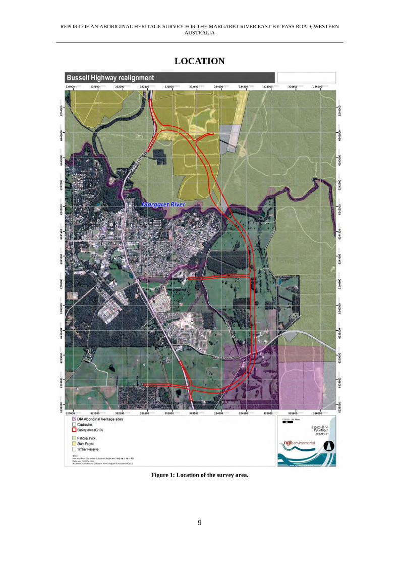
LOCATION
Figure 1: Location of the survey area.
REPORT OF AN ABORIGINAL HERITAGE SURVEY FOR THE MARGARET RIVER EAST BY-PASS ROAD, WESTERN AUSTRALIA
10
ETHNOGRAPHIC & HISTORICAL BACKGROUND
TRADITIONAL NYUNGAR CULTURE The southwest of Western Australia is considered to form a distinct cultural bloc defined by the distribution of the Nyungar language. Before Nyungar was used as a group or linguistic name the southwest people recognised themselves, their language and culture, as ‘Bibbulmun’ (Bates 1985). Daisy Bates writes that the Bibbulmun people were the largest homogenous group in Australia. Their land took in everything to the west of a line drawn from Jurien Bay on the west coast to Esperance on the south coast (Bates 1966). Bates also mentions that over seventy groups that shared a common language and some local variations occupied the Bibbulmun area.
All coastal Bibbulmun were Waddarn-di – sea people, and called themselves, and were called by their inland neighbours, Waddarn-di Bibbulmun. The inland tribes were distinguished by the character of the country they occupied. They were either Bilgur (river people, beel or bil-river), Darbalung (estuary people), or Buyun-gur (hill people – buya-rock, stone, hill), but all were Bibbulmun [Nyungar] (Bates 1985:47).
Tindale (1974) identified thirteen ‘tribal groups’ in the southwest based on socio-linguistic boundaries and minor dialect differences. He describes the Pibblemen Bibbulmun’s territory as ‘the lower Blackwood River, chiefly on the hills between the Blackwood and the Warren Rivers, east to the Gardner River and Broke inlet; on Scott River; inland to Manjimup and Bridgetown’. The Pibblemen people maintained a number of paths between the Vasse area in the north and Augusta to the south, and as far as Bridgetown to the east, which followed the Blackwood River. The Nyungar or Bibbulmun people of the south-west were a distinct group in that their initiation practices varied markedly from their desert and semi-desert dwelling neighbours. Unlike the desert people, the Nyungars did not practice circumcision or sub-incision, but rather practiced a ritual of nasal septum piercing and cicatrisation of the upper body (Bates 1985: 151-162). The people who followed these socio-religious practices have been described by Berndt and Berndt (1979), as being of the ‘Old Australian Tradition’. Within the Bibbulmun, two primary moiety divisions existed, the Manichmat or ‘fair people of the white cockatoo’ and Wordungmat or ‘dark people of the crow’, which were the basis of marriage between a further four class subdivisions: Tondarrup, Didarruk and Ballaruk, Nagarnook (Bates 1985). Bates describes the only lawful marriage between the groups to be “the cross-cousin marriage of paternal aunts’ children to the maternal uncles’ children”, and states that the four clan groups and relationships, under different names, are “identical in every tribe in Western Australia, east, north, south and southwest…” (Bates 1966:24-25). Each socio-linguistic group, sometimes referred to as the ‘tribe’, consisted of a number of smaller groups. Each of these smaller groups was made up of around 12 to 30 persons, related men, their wives and children and, at times, visiting relatives from other groups. These subgroups could be described as a family, a band or a horde. For every subgroup there was a tract of land with which they most closely identified themselves with, an individual or a group’s land was called their Kalla or fireplace (Moore 1884). This referred to an area of land which the group used and over which the members of the group exercised the greatest rights to its resources. It was also the area for which the group would act as custodians of. Other groups would also have some rights of access and use gained through marriage.

REPORT OF AN ABORIGINAL HERITAGE SURVEY FOR THE MARGARET RIVER EAST BY-PASS ROAD, WESTERN AUSTRALIA
11
Ownership rights to land were held by groups of people linked through common descent; there was definite ownership of land in both social and personal ways. As well as belonging to a local descent group by birth, each individual simultaneously belonged to an economic or food gathering group (Le Souef 1993:30).
There are two forms of socially organised relationships to the land, a spiritual association and an economic one. Stanner (1965) uses the terms ‘estate’ and ‘range’ to distinguish these two different associations, he writes that the ‘range’ was that land in which the group ‘ordinarily hunted and foraged to maintain life’. The ‘estate’ refers to the spiritual country and which may be ‘owned’ by either an individual, by the group or by part of the group. The relationship to ‘estate’ is mostly religious; however there is also an economic benefit. The estate can be considered the country or home of a group. It is sometimes referred to as the ‘Dreaming place’ and as such includes all religious sites, myths and rituals that occur on or about that land. In this way ‘estate’ forms part of the Aboriginal ties to Dreaming and place (Stanner 1965).
There is a clear relationship between the individual and the land, which is expressed in a number of ways. There is a direct link between the mythic heroes and spirits of the dreaming and the land. Relationships with these beings, which are transmitted through birth, descent and marriage (to a lesser extent), are a reciprocal arrangement of rights and obligations and they are vital for claiming rights to the land (Silberbauer 1994:124).
The link between the individual and the land comes from the conception site, where the animating spirit enters the mother and thus there is a direct connection between the land, spirit and the identity of the individual (Machin 1996). The spiritual ties with the land strengthened economic rights and land usage involved both ritual and social connections (McDonald et al., 1995). Land use or ownership in traditional Aboriginal Australia is based on a religious view of the world and the position of people in it. This religious view is most often referred to as the Dreaming; the Dreaming is an ideological and philosophical basis for a close emotional connection between Aborigines and their land (Machin 1996). The Dreaming refers to a distant past when the world had yet to be fully created. Dreamtime stories refer to mythic beings that roamed the Earth creating plant and animal species. During the struggles of these mythic beings many landforms such as hills and rivers were created. The landscape bears testimony to the struggles of creation and is studded with sacred sites recalling the Dreamtime. These sites are owned by or belong to either one or more groups, and so such sites have a shared significance amongst the local population. The shared spiritual significance of these sites had a function of bringing together different groups. Another function of these shared sites is that knowledge of the local myths created rights of use to the land.
Rights are recognized through active social relations, a process symbolized through the possession of knowledge. That is, knowledge is only gained through participation in social relations and rights to the land are reliant on the possession of relevant religious knowledge (Machin 1996:11).
Traditionally, the Bibbulmun Nyungar people recognized six different seasons in the year. Each of these seasons coincided with a particular seasonal abundance of a wide variety of food resources. Fish traps such as the well documented Barragup Fish Trap were used to catch large migrations of estuarine and river fish. These fish traps were so efficient at providing food that they formed the basis of regular meetings between neighbouring groups and were a focus of cultural activities (Contos et al 1998; Bates 1985). Spears Gidji-garbel & Gidgie-borryl, axes Kadjo and digging sticks Wonna, were used to hunt and procure food (Berndt 1979; Tilbrook 1983). Trees known to contain bird’s nests or possum hollows or to have hives with native honey in them had notches cut into their trunks to facilitate climbing. The Bibbulmun Nyungars had an extensive knowledge of plants for both food and medicinal uses (Bird & Beeck 1988; Meagher 1974).

REPORT OF AN ABORIGINAL HERITAGE SURVEY FOR THE MARGARET RIVER EAST BY-PASS ROAD, WESTERN AUSTRALIA
12
SETTLEMENT AND SOCIAL DISRUPTION Prior to settlement in Western Australia, the Dutch and the French, as well as sealers and whalers of mixed nationalities, had already landed and made contact with the local Aborigines. From the beginning of the 17th century the Dutch had been sailing north along the Western Australian coast en route to the Dutch East Indies, and ships were often forced close to the coast by the prevailing south westerly winds. Many who realized their proximity to the coast too late came to grief there. The early reports by the Dutch described the coast as a bleak and desolate place. Apart from some expeditions to try and rescue shipwrecked sailors, the Dutch showed little interest in Australia (McDonald et al., 1995). The Dutch flute Elburgh is reported to have recorded the first brief description of the Aborigines near Cape Leeuwin in 1659:
“An armed party sighted three Nyungar Aborigines wearing kangaroo skin cloaks. At the sight of the European sailors, the tribesmen ran off into the bush leaving behind spears and small axes” (Creswell 1989).
Contacts were also made by the whalers and sealers who visited the coast to take on water. The sailors were also interested in the local females, and this interest was discovered by the first settlers to the Augusta region when the local Aboriginal group used the English word ‘woman’ when referring to females (Shann 1926). Two further items point to considerable pre-colonization contact with whalers, the first being that in 1827, Major Lockyer of the Albany garrison ‘reported incidents of Aboriginal women being found on offshore islands, kidnapped and then abandoned by the sealers’. Secondly, when the first French and British expeditions of the late 17th and early 18th centuries did contact local Aborigines, they reported that while the men were approachable and friendly, they kept their women and children hidden or some distance away (Colwell 1970). The first ‘settlement’ in Western Australia was the establishment of a garrison of soldiers at King George Sound in 1827. In 1829 the Swan River colony was founded and the settlement of Augusta took place in 1830. Initially relations between the Aborigines and the settlers were friendly; the Nyungar people showed the settlers to water sources and the Europeans shared game shot while being guided by the Nyungar men (Shann 1926). On the 1st of May 1830, the schooner Emily Taylor dropped anchor in Flinders Bay close by what is now Augusta. On board were the first settlers who were to create the town of Augusta, the Molloy, Bussell and Turner families and their servants, Dr Green, Sgt Guerin and a detachment of soldiers (Pickering, 1929; Turner, 1956). Horses, cattle, machinery, merchandise and general stores of every description were rafted ashore through the surf. Turner (1956) recounts:
While these strange operations were being enacted, natives lurked curiously in the background, watching every movement; it was something entirely new to them. The natives were timid and shy, but to cover this they ‘simulated rage,’ gesticulated and jabbered at the intrusion on their domain; but the settlers advanced, calling ‘abba abba’ and some of the few aborigine words they had already learned, and by offering a few trinkets and with friendly signs they soon established peace, and some natives led them to a ‘soak’, no doubt the spring so often referred to later (Turner 1956:89).
Berndt (1979) suggests that the Aboriginals believed that the first European settlers, because of their light skin colour, were souls of the dead (djanga) returned from Kurannup, the home of the Bibbulmun dead located beyond the western sea. He describes:
“…the kanya (soul of the newly dead) going first to the tabu-ed moojarr or moodurt tree (Nuytsia floribunda or Christmas tree), where it rested on its way to Kurannup…here, their old skins were discarded and they appeared ‘white’” (Berndt 1979:86).

REPORT OF AN ABORIGINAL HERITAGE SURVEY FOR THE MARGARET RIVER EAST BY-PASS ROAD, WESTERN AUSTRALIA
13
Many of the tracks created by the Nyungar people were used by the early settlers to explore the land and eventually to create the basis for roads upon these tracks, many of which still follow similar alignments. Not only do the original paths used by the Nyungar people often coincide with existing road alignments but often link traditional areas of importance which are now the location of town sites (Collard 1994). Augusta, Busselton and Bunbury, formally known as Talanup, Yoonberup and Koombanup by the Nyungar people, were important regional areas providing good hunting and food gathering opportunities. The settlers in Augusta employed the local Nyungars as guides and trackers and used the Nyungar paths through the bush to reach the Vasse district (Jennings 1983). In November of 1833, Georgina Molloy wrote to a friend in England that the Aborigines in Augusta were ‘fond’ of the settlers, and that the settlers and Aborigines lived “on the most peaceful terms”. In the same letter, which took four months to complete, she writes of “being troubled with natives who, though amiable, required watching in case of theft” (Pickering, 1929:47). Whilst relations between the settlers and the Aborigines began amiable, pilfering of food and implements soon tested this. Early in 1834, an incident occurred in which a group of around 30 Aborigines attempted to intimidate Mrs Molloy and Fanny Bussell whilst Captain Molloy and other male members of the settlement were absent. The Aborigines attempted to take a tablecloth and some potatoes before Mrs Molloy’s servant Dawson (the only male present) produced a pistol and a rifle that scared the aborigines off. From the Molloy house the Aborigines went to Miss Bussell’s house from where they took three salt sellers. The Aborigines valued glass (dillilah) for pointing their spears. When the theft was discovered the settlers had the garrison of soldiers apprehend the Aborigines. There was an exchange in which the soldiers either threatened to shoot or to bayonet the women or woman responsible (the two accounts from Mrs Molloy and Miss Bussell vary in detail). The salt sellers were recovered without any actual violence-taking place, yet it marked a significant worsening of relations between the Aborigines and the settlers (Pickering 1929; letter of Fanny Bussell dated 16/2/1834). Georgina Molloy wrote of the incident:
“I am sure if Dawson had not been present, Mrs. Dawson and I and the poor children would have been murdered or otherwise injured, for it seemed that mans full intention to prevent me leaving my own premises. It gave me a great fright” (Pickering 1929).
In 1837, three Nyungar men were killed as a reprisal for the theft of a heifer, in the same year a house belonging to the Turner family in Augusta was burnt to the ground and the Government store was raided (Jennings 1983). As the settlers expanded their farming operations and took up more and more land, the pressure on the Nyungar people increased as the two lifestyles met. Cattle were speared and settlers attacked. Reprisals led to resentment and conflict replaced the early good will. On June 28, 1837, Lennox Bussell wrote a letter to Captain Molloy in Augusta describing the killing of three Nyungar men as a reprisal for the Aboriginal people taking a heifer (Jennings 1983). On July 9, he wrote again to Captain Molloy about the reprisals.
….I do not view the present daring outrage (The taking of the heifer) as a mere breach of the law but as an act of open hostility and defiance… we have inflicted upon the offenders the only adequate punishment in our power… Let us first convince them of their inferiority and then extend to them our protection and it will be gratefully accepted, otherwise with the vanity inherent in a savage, they will fling back the proffered gift and considering every act of forbearance a confession of weakness and inability, will cause in their final subjection which sooner or later must be effected, a sacrifice of life on both sides double or treble to what would have befallen if severer measures had been adopted from the first (Letter to Captain Molloy from Lennox Bussell, dated July 9, 1837, cited in Jennings 1983).

REPORT OF AN ABORIGINAL HERITAGE SURVEY FOR THE MARGARET RIVER EAST BY-PASS ROAD, WESTERN AUSTRALIA
14
As the settlers demand for labour increased, Aboriginal people were employed as farm labour and domestic help in exchange for goods such as flour, sugar and tobacco. The Aborigines became increasingly dependent on these European food supplements and, whilst still practicing some aspects of their traditional economies, the traditional lifestyle of the Nyungar people may have ended as early as the 1860’s (Berndt and Berndt 1979). This relationship between the settlers and the local tribes spelt the beginning of the end for the Aborigines ‘fully traditional economies’ (Moore 1989). Hamelin Bay became a port for ships loading timber cut in the Karridale area in 1875 when Willie Eldridge was granted a fourteen year lease to cut timber in a 75000 acre area around Augusta-Hamelin. There were no facilities to load the ships and the timber was towed into the water by oxen and then loaded onto lighters (sailing barges) to be loaded on the ships. After losing one ship and cargo, and unable to find either markets or financial backing, Eldridge was forced to admit defeat. He was, however, responsible for erecting buildings, building roads and establishing Hamelin Bay as a shipping harbour and base for a business (Creswell 1989). Maurice Cole Davies followed Eldridge in expanding the timber industry in the region. M C Davies took over Eldridge’s expired lease in 1878 and in 1881 had laid a rail line linking Boranup and Hamelin Bay, in 1882 construction began on a 1800 foot long jetty at Hamelin Bay. Many miles of rail line were laid linking mills to Hamelin Bay, which rapidly became a thriving port. In 1885 Hamelin Bay was a ‘considerable township’. Around 1895 the Cape Leeuwin lighthouse was commissioned and completed in 1896. One person known to have worked on the lighthouse was Joe Hill who was an expiree (a convict who had served his time) employed to drive a bullock team carting stone (Creswell 1989). Mr Joe Hill is a European ancestor of several Busselton Nyungar families. M C Davies successfully tendered for the construction of the original Alexander Bridge was 400 feet (122 meters) long and seventeen spans wide. The original bridge was located a short distance upstream from the present bridge and much of its structure survived until 1982 when a summer flood destroyed it. It’s location has been a popular picnic and bream fishing spot for many years (Creswell 1989). As a shipping port and timber town, Karridale and Port Hamelin lasted around 35 years. By 1910, most of the best timber in the area has been removed and the mill at Karridale has closed. With the mill closed, Karridale almost disappeared overnight (Creswell 1989). As work on the timber mill finished, the Nyungar people who worked there moved with the industry to other locations. Busselton and the Geographe Bay area also provided other employment opportunities.
In all likelihood the Aboriginal population of the area was attracted to the towns, timber camps and homesteads between the 1860’s and 1880’s, although as suggested above, a certain degree of mobility may have been maintained with Aboriginal people travelling as itinerant seasonal labourers. Mervyn Longbottom, a long time resident at Darradup, recalled that about the turn of the century there were still Aboriginal groups moving about that area, using traditional foods and camping places. Although they still had some traditional tools, they had European clothes and no longer wore skin cloaks. He also recalled that two hundred or so Aboriginal people would annually pass across the Darradup ford en-route to visit a ‘king’ at Karridale (Hallam 1979 cited in Gibbs 1989).
Aborigines were seen throughout Western Australia as a convenient source of labour which required little, if any, payment for work, even though the early settlers often relied on the extra labour the Aborigines were able to provide to establish European farming techniques. During the course of a parliamentary debate in 1883, John Forrest stated that, ‘Colonization would go on with very slow strides if we had no natives to assist us’ (Goddard and Stannage 1984). In 1898, John Forrest wrote a circular to the Aborigines department stating the ‘care and protection’ of Aborigines had now ‘developed on the Government’ and that, while the Government and its bureaucracies must provide help to aged and sick Aborigines, it was to be given’ with due regard given to the practice of strict economy’. In the same circular, Forrest
REPORT OF AN ABORIGINAL HERITAGE SURVEY FOR THE MARGARET RIVER EAST BY-PASS ROAD, WESTERN AUSTRALIA
15
takes care to point out that ‘no able bodied natives who can provide for their own maintenance should receive rations’ (Battye Library Busselton Court House records. ACC #594). Missionary work had begun as early as 1840, and in 1841 the Reverend George King went ‘amongst the blacks and collected eighteen children’ aged between five and ten. It was his belief that the children could be ‘civilized’ only if they were kept away from ‘the dark influences of the wandering tribe’ (Barley 1984). The missionaries took children from their parents and interfered with traditional marriage arrangements in order to remove their ‘converts’ from the influences of traditional Aboriginal culture. The hardships facing the Aboriginal people steadily increased as their mode of life clashed with European notions of farming. Some settlers complained about Aboriginal hunting and fishing practices. Fish traps such as those at Wonnerup and Augusta were traditionally very important to the Nyungars, providing a means to feed large numbers of people. The fish traps were often the reason Nyungars visited certain locations, to take advantage of seasonal runs of fish, which provided enough food to enable large ceremonial gatherings. The settlers destroyed many fish traps in an effort to discourage Aboriginal people from coming onto land, which was being farmed or otherwise occupied by the settlers. The weir type fish traps built by the Nyungar people were also sometimes a hazard to navigation and destroyed because of this. In 1899, the Government passed a law prohibiting the building or use of fish traps, which caused a considerable blow to the traditional Nyungar economy (Tilbrook 1983). During the late 1800’s and early 1900’s, the Government passed a series of Acts which increasingly eroded the Aboriginal people’s civil liberties. The Industrial Schools Act (1874) empowered managers of Aboriginal Missions to keep Aboriginal children to the age of 21 and place them as domestic servants or apprentices without their parent’s permission. The Aborigines Protection Act (1886) introduced controls over Aboriginal employment. In 1889, the Constitution Act was introduced, it specified that 5000 pounds or 1% of the annual colonial gross revenue, whichever was greater, was to be used to provide for the Aborigines. The Aborigines Act (1897) repealed the Constitution Act (1889) and transferred control of Aboriginal affairs to the West Australian Government, which acted through the Aborigines Department, formed in the same year. Following the Roth Royal Commission in 1904, in which Roth described the Western Australian Police’s treatment of Aborigines as ‘most brutal and outrageous’ and described the conditions experienced by many Aborigines as ‘resembling cruelties committed in the Dark Ages’, the Aborigines Act (1905) was introduced (Haebich 1988). The Aborigines Act (1905) allowed the Government to remove Aboriginal people to live in mission camps such as Roelands and Carrolup, and to control many aspects of their lives including marriage and employment. Other hardships for the Aboriginal population included the Dog Act (1885), which forced Aborigines to license their dogs or risk their destruction. As the Nyungar people used the dogs to aid in hunting and providing for themselves, the Dog Act (1885) represented a blow to their means of survival. Nyungar people adapted to the new conditions as best they could, obtaining mostly short term seasonal work as stock workers, domestic help, farm labourers and foresters (Haebich 1988). Fringe camps occurred on the outskirts of towns as Aboriginal people followed ‘runs’ from one area of seasonal employment to another. Many Aboriginal people lived in the bush between jobs, surviving on whatever game or bush tucker was seasonally abundant (Tilbrook 1983). Those Aborigines who were working as farm labour and domestic help found that competition for employment increased suddenly with the influx of people attracted to Western Australia during the gold rushes of the 1880’s and 1890’s (Tilbrook 1983). Further inequity saw the Aboriginal unemployed receive a lower sustenance rate than the white unemployed during the Depression of the 1930’s. Living more or less permanently in fringe camps, seeking out seasonal employment and supplementing their diet with game, fish and

REPORT OF AN ABORIGINAL HERITAGE SURVEY FOR THE MARGARET RIVER EAST BY-PASS ROAD, WESTERN AUSTRALIA
16
some bush tucker was a lifestyle, which predominated for the Aboriginal people late into the 1960’s (McDonald 1995). In 1965, when two Busselton Nyungar families were moved from ‘miserable primitive humpies’ to government housing, the newspaper article which reported the move stated that, “although the men were hard and conscientious workers, they had never been able to secure permanent employment” (West Australian 29/4/1965). Many of the southwest’s Nyungar people have lived in fringe camps at some time during their life, creating a living for themselves doing seasonal work and often supplementing their diet with fresh caught fish from the ocean.
WATER AND ABORIGINAL SIGNIFICANCE There is no doubt that water, especially fresh water was of vital importance to traditional Aboriginal people right across Australia, the rivers, pools and wetlands were a source of food, linked campsites along walk tracks and in the case of the Blackwood River defined the territories or estates of the Pibblemen and Wardandi people (Hallam 1979). As the Blackwood River, particularly in the lower reaches created an impassable barrier to people without boats the places where the river could be crossed (Hut Pool and the mouth near Augusta) created an intersection of tracks and as such became focal points of traditional camps where ritual activity often took place. At Hut pool Mrs Vilma Webb (per com 2005) said that this ford was a place where the trading of women from the Pibblemen to Wardandi would take place for betrothals. Gibbs (1989) drawing upon the writings of Bates states that a number of theses paths were maintained as initiate’s tracks, with one of the longest following the Blackwood River south from Augusta through Nannup, Demark, Albany and eventually to Ongerup. Other paths from the Vasse Estuary followed the St John Brook to Barrabup Pool and then south along the Milyeannup Brook to Lake Jasper (Collard 1994; Kelly per com 2004). Camps along these water courses were often places that had Nyungar names and were noted by the first Europeans’ early maps.
It should also be recognised that a large number of Aboriginal names have been perpetuated in modern maps, although their original contexts and meanings are unknown. An examination of older maps, such as the 40 chain series held in the Battye Library, do not reveal much more detail, although a limited number of specific features, especially springs and watercourses, do have Aboriginal names indicated….Kwaggamai’erup [ spring near Nannup], Dallatgurup [ part of the Blackwood River, Kweelyjup [ lower Blackwood], Eedagulup [River bar Blackwood] (Gibbs 1995).
The Regions Rivers were also important sources of food. Marron and other fresh water Cray fish were an important food source that was caught in the pools along rivers and creeks throughout the region. Fish traps were also constructed on creeks, in rivers and in the tidal zones of estuaries. As these were efficient and abundant, harvests could be made. These places also created focal points for traditional ceremonial activity where large gatherings of Nyungar could be maintained (Gibbs 1995). Archaeological research in the South West has also confirmed that all water sources were important to prehistoric traditional Aboriginal people for campsites and food procurement activities. Archaeologists have recognised there is a higher likelihood of finding artefacts from prehistoric campsites around freshwater sources, such as rivers, creeks, lakes and estuaries. Lake Jasper for example has a rich archaeological record with 10 such sites found upon the lake bed and margins showing such camps prior to the formation of the lake some 4,000 years ago. Charles Dortch from the W.A. Museum said that these sites were extremely significant sites to the understanding of the region’s pre-historic Aboriginal settlement patterns. They represent camps that have been in use upon the wooded margins of a stream prior to the area becoming inundated by the formation of the lake some 4,000 years ago when sand dunes moved into the area and blocked the stream, flooding the area.

REPORT OF AN ABORIGINAL HERITAGE SURVEY FOR THE MARGARET RIVER EAST BY-PASS ROAD, WESTERN AUSTRALIA
17
The submerged stone artefact scatters at Lake Jasper, at least those at depths sufficiently great that one can be reasonably satisfied that they have remained permanently underwater, differ from those in terrestrial open-air sites in that they have been ‘sealed’ by their submergence, with definite cut-off dates corresponding to the time when the surrounding trees or other plants were flooded and died. This, of course, provides a minimum age for the artefacts, and thus the temporal control necessary for determining their actual radiocarbon age, by means of excavation, using delicate suction techniques capable of removing sandy sediments in 1 or 2cm levels. Radiocarbon dating of charcoal or other datable material in situ in the upper parts of such lake floor excavations can show whether the artefacts exposed on the lake floor are contemporaneous with the dated stumps in situ in it. Once this was established, it would be possible, in a programme of species identification of plotted trees and other plants, to reconstruct the plant associations or habitats surrounding the archaeological sites, creating an unquestionably valuable record of uncontaminated late Middle Holocene or older campsites in their formerly terrestrial settings, and having the potential for the preservation underwater of wooden implements and other organic remains associated with human activities (Dortch 1990:7).
The records of registered archaeological sites upon the DIA sites register also confirms that within the study area most artefact sites are located upon or in the vicinity of the area’s water ways. From the archaeological and ethno-historic records from the region Dortch (2002) has also developed a prehistoric model of hunter-gatherer socio-economic and territorial organization in the southwest coastal regions. In this model Dortch concludes that the distribution of topographical features such as estuaries, rivers and wetlands would have had a strong bearing on the population distribution; “rivers, wetlands and lakes, dune fields, escarpments and other topographical features that certainly would have influenced the positioning of estate boundaries and band foraging ranges were seen as focal points for activity with major topographical features such as the Blackwood river as being important cultural boundaries between Aboriginal groups” (Dortch 2002). In regards to this last point O’Connor writes;
Archaeologists and Anthropologists generally agree that prehistoric land use patterns were based on the seasonal migrations between the coastal plain and its hinterland to exploit the various food and water resources. There is a tendency, in all parts of the project area, for sites to be located near the various water sources, such as rivers, creeks, lakes, swamps and estuaries. Based on the existing information, the most important river systems in the project area are the Busselton Drainage Basins, Margaret River and the lower Blackwood River (O’Connor et al 1995).
Comparative studies with regards to the significance of water that have been conducted in the Northern Territory where it has been found that water bodies also served the above cultural functions as focal points for resource activity and ritual aggregations. In these studies water bodies also almost always had mythic dimensions. Studies by Barber and Rumley (2003), Langton (2002), Toussaint et al (2001) and Yu (2000), state that Aboriginal people as with the land conceptualize that water sources such as rivers, lakes and wetlands have derived from the Dreaming, a time when the world attained its present shape. These studies emphasise the importance of stories about the actions of mythic beings in the origin and maintenance of such water sources. In these stories cultural affiliations to water are expressed in many ways, through social etiquette, narratives about places, rituals and practices of such rituals. Water is described as the living element that both creates and defines the shape and character of the country and gives it sacredness and identity (Jackson 2004). In the south west of Western Australia several early writers recorded parts of the Aboriginal mythology about water, however clearly a lot of knowledge and stories have been lost in the

REPORT OF AN ABORIGINAL HERITAGE SURVEY FOR THE MARGARET RIVER EAST BY-PASS ROAD, WESTERN AUSTRALIA
18
years since settlement and no complete record of traditional mythology was ever made. Many of the European observers did note the importance of water to the traditional people and that water also occupied a place in the traditional mythology. The small parts of mythology recorded and references to the Waugal or a snake like spirit of water are widespread both throughout the south west of Western Australia and other parts of Australia. Bates (1966) recorded that in the southwest: “Their only deity was a Waugal or serpent-god that dominated the earth, the sky, the sea, and punished evil doers” (ibid 1996).
All permanent native waters have legends attached to them, legends of the “dream” time, which go back to the days when birds and animals possessed human attributes, or were human beings, or were groups of which the bird or animal was representative, or were magic animals and birds possessing the power of human speech. The natives cannot say that the “founders” of the various permanent waters were altogether human, although birds or beasts, or half bird half human, but the bird or animal name only is always given in the legend never a human name (Bates 1966:157).
Another reference to the Waugal or snake like spirit of water was recorded by Salvado (1850) and indicates the fear or reverence with which Aboriginal people regard the spirit of water and also the harmful powers of the ‘serpent’.
If the natives are afraid to walk about at night time, for fear of Cienga, they dread even more going near large pools of water, in which they believe there lurks a great serpent called ‘Uocol’ [Waugal], who kills them if they dare to drink there or draw water during the night. A large number of natives came to me one evening asking for water. The first ones took all I had and drank it, and the others, about fifteen of them, asked me to go to the pool nearby to get some for them. I showed them the bucket and told them to go themselves. They all fell silent, and no one dared take the bucket, or tell me what they were afraid of, until, about an hour later, one of them said respectfully: ‘N-alla cape uoto, chetchet cuaragn: nunda uoto quaragn iuad’ (If we go and take water, very soon we will be killed, but if you go, you will be alright). I saw quickly that they had some superstition on the subject, and said that I would go with them, with the idea of banishing their false fears. As we went to the pool or stream, they made me go ahead, and all followed me in single file, in deep silence. While they were quenching their thirst, I started to move away, but immediately they shouted, ‘Nanap, nanap’ (‘Stop, stop’), fearing that I was going to leave them on their own. As we began to go back to the hut, they ran ahead and preceded me, again in single file, so that I came last. When I reproached them for their superstitious ideas, they replied condescendingly: ‘Nunda tonga but’ (‘You don’t know anything about it’). However much the natives of both sexes like to swim ‘dog-paddle’ style in summer, they will never go into water that is dark and deep, because they say that the serpent Uocol is there, and they are afraid of him even during the daytime (Salvado 1850).
Salvado (1850) recorded that the Aborigines ‘hide carefully from strangers their customs and, in particular, their beliefs’. Moore (1842) described the Waugal as a ‘huge winged serpent’ that lived in dark waters and was feared as a harmful force. A woman who fell ill or miscarried during a pregnancy was called Waugalan. The Waugal is of particular danger to pregnant women and so associated with fertility if in a harmful rather than replenishing manner. Not all of the stories regarding the creation of water sources or rivers in the southwest and wider Nyungar territory involve the Waugal or snake like spirit of water. In a story regarding the creation of the Margaret River a magic stick is the means of transformation or creation of the Margaret River.

REPORT OF AN ABORIGINAL HERITAGE SURVEY FOR THE MARGARET RIVER EAST BY-PASS ROAD, WESTERN AUSTRALIA
19
The native name of the Margaret River was Wooditchup, named after Wooditch, who made the River with his magic wand. Nearby is Milyanup, the place of Milyan, the wife of Wooditch, and daughter of Ngungaroot. Milyan, who was a very fine looking young woman, fell in love with the Wooditch. Wooditch was a medicine man who was known as the ‘Mulgar Kattuck’ which means ‘medicine power possessor’. He could transform one thing into another and do almost anything he chose by a mere touch of his magic wand. Wooditch became violently in love with Milyan the moment he saw her. He forthwith made know his desires to Ngungaroot her father. The old man became very wrath and said that his daughter was already promised to Wooditch’s eldest brother, Ngorable, and that as soon as Ngorable came down from Dudinalup she would be handed over to him for his lawful wife. Wooditch was not deterred by this reply, as he was quite confident that Milyan loved him better than any man she had ever seen. He decided to employ his wonderful magic to get her for his wife. For some considerable time he very cautiously watched the movements of Ngungaroot and his daughter. One night, before the moon rose, the old man Ngungaroot got up, gathered all his equipment, his pear, axe, boomerang, hunting knife and digging stick, awakened Milyan, and bade her to take her skin bag and follow him. By midday, they reached the Kalkardup country. There the old man mysteriously fell asleep. While he slumbered, Wooditch, who, by his magic power, had sent the old man to sleep, made his appearance to Milyan, and beckoned her to follow him quickly. After a few minutes, Ngungaroot awoke, sprang to his feet, and finding Milyan gone, set off in search of her. He picked up her tracks and would soon have overhauled the runaways but Wooditch, seeing him coming with his beard in his mouth, muttering curses and preparing his weapons to strike, again exercised the power of his magic wand. He placed the wand upon the ground and commanded a big river to run between them. The old man was dumbfounded. Being a man of great strength, he pulled up large trees by the roots and threw them across the river, but the current was so strong that it washed them down the stream. When the afternoon was half gone, the two enemies, walking on opposite banks of the stream, reached the ocean, where Wooditch gave river a lead into the sea. The water was running so swiftly that Ngungaroot was still unable to cross and remained on the other side of the river, yelling his curses to the runaways on the opposite bank. Wooditch and Milyan were now very hungry, and decided to go out on to the reefs at the mouth of the river, to spear groper, which were very plentiful there. They set off, leaving Ngungaroot still raging at the other side of the river. After a while, the rushing waters subsided and Ngungaroot managed to get over to where the young people were. He was on the point of seizing his daughter, when Wooditch struck him with the magic wand and turned him into a groper, which disappeared into a deep hole in the reef. As the couple returned to the wide beach in order to make a fire to roast their fish, Wooditch speared a big groper which was swimming close to the shore. He left it with his wand leaning against it while he helped Milyan to roast the other fish. While they were eating their fish, Wooditch began to feel very sorry he turned the old man into a groper, for Milyan kept bursting into tears over the loss of her father. He told her that if the big fish beside him should happen to the groper who had been her father, he wished it would turn into the old man again. Immediately, the transformation took place, and Ngungaroot was restored to them. He was now resigned to the union of Milyan and the powerful Wooditch. They left the neighbourhood and lived happily for many years at a place which has ever since been known as Milyanup. When Ngungaroot got very old they went back to Wooditchup and lived by the river that Wooditch had made. After they had been there a little while, one day Ngungaroot went into a cave and died. The cave is on the eastern end of the cliff at Walcliffe on the Margaret River. This place is ‘Wainilyinup’ or ‘the place where the old man died’ (Buller-Murphy 1959).

REPORT OF AN ABORIGINAL HERITAGE SURVEY FOR THE MARGARET RIVER EAST BY-PASS ROAD, WESTERN AUSTRALIA
20
Another story that is believed to have been recorded in the Kojonup district tells of a crow and a hawk creating a fresh water soak.
…Dinah, the mother of the late, distinctive Ted Smith, told (him) this legend of the Kojonup district. The country was gripped in drought and the only known water was salty. The health of the parched Aborigines, birds and animals deteriorated. An eagle-hawk, soaring about the sky and swooping to earth, observed that a fat and shiny crow had a wet beak, wet with fresh water. The eagle-hawk, seething with unparalleled fury, attacked the cunning crow. In so doing his claws split the rocks and the blood of the attacked crow was splattered over the surrounding rocks and earth. So, a fresh water soak is to be found in the Wakhinup area, hidden amid rocks and surrounded by rich, red loam (Bignell 1971).
Another story that was related to the current researcher, by Doc Reynolds an Esperance traditional owner was about the creation of the Young River near Esperance. This story also involves the action of an eagle and a crow. Reynolds states:
The Noongar people camped along the banks of the Young River, because the Eagle chased them all away from the fresh water. He wanted to keep it all for himself and not share with anyone. One day all the fresh water dried up. The eye of the crows which were the people had all turned white because they were forced to drink salty water. The Crow and Eagle then had a big fight and the Crow speared the Eagle and killed him. The Eagles wife, the Mallee Hen dragged his body way down to the estuary of the river and buried his body on the east side. Because of the Mallee Hens scratching up of all the sand to bury her husband, her foot markings can still be seen today. The hill on the east side looks like a Mallee Hens nest, were the ‘walitj’ is buried (Doc Reynolds, per com; Goode 2005).
Despite these and no doubt other such tales about the moral aspects of water the predominant theme with regards to water is the Serpent mythology. Radcliffe-Brown (1926) wrote about ‘the Rainbow Serpent Myth of Australia’. He wrote that throughout Australia there is a belief in ‘a huge serpent, which lives in certain pools or water holes’. He wrote that the serpent was sometimes associated with the rainbow and it could also occur or be seen as “a wavy dark shadow” in the Milky Way. Certain commonalties exist in the myth of a serpent type creature that has creative and punitive powers and that lives in dark or deep pools of water. Radcliffe-Brown points out the similarities of this widespread myth, although throughout his article he refers to different names and different attributes of the ‘Rainbow serpent’ in different regions.
I have been able to trace the belief in the rainbow-serpent, living in deep, permanent water holes, through all the tribes from the extreme southwest at least as far north as the Ninety Mile Beach and eastward into the desert. In the tribes around Perth it is called wogal, and certain water holes are pointed out as being each the abode of a wogal. It is regarded as dangerous for anyone except a medicine man to approach such a water hole, as the serpent is likely to attack those who venture near its haunts. “It generally attacks females, and the person whom it selects for its victim pines away and dies almost imperceptibly. To this creatures influence the aborigine’s attribute all sore and wounds for which they cannot otherwise account (Radcliffe-Brown 1926).
The notion of a serpent type deity associated with water also occurs throughout the northern and eastern parts of Australia, at the Daly River in the Northern Territory a serpent like deity is held responsible for the creation of rain and ceremonies are performed to this dreaming character to bring the rain. In this area the deity is the spirit of water, rain and flood that is depicted in the rock art of the Wardaman people who have many sites where hundreds of cuts are incised into the rocks for rain making and to control the cycles of nature governing the monsoonal floods. In the north east goldfields of Western Australia the serpent is called the Tjilia or the two carpet
REPORT OF AN ABORIGINAL HERITAGE SURVEY FOR THE MARGARET RIVER EAST BY-PASS ROAD, WESTERN AUSTRALIA
21
snakes. This dreaming track is associated with the creation of the vital waters thought out the Western Desert, and there are numerous highly secret, scarred sites located upon this track which are important ceremonial centres. Lake Miranda is an important site where this serpent deity resides as is Logan spring in the Bar Smith ranges near Wiluna (Liberman 1976). The Rainbow serpent as a spirit creature is believed to have excavated the beds of the rivers during its travels throughout Aboriginal Australia. It is often the belief that it had ‘reached down from the sky to the waterholes and pools, bringing water to the earth’ (Jackson 2004). Throughout Arnhem Land and the Kimberley’s the Rainbow Serpent is associated with other myths regarding fertility and is sometimes regarded as male and at others as female (Reed 2001). Other similarities with the Waugal or Marchant include the Rainbow Serpent having powers to harm, particularly those who offended against it.
“In the beliefs of many Aboriginal tribes, the rains would dry up, the earth would become parched, and life would cease to exist if it were not for the Rainbow Serpent” (Reed 2001).
In the Esperance region the Mythical serpent that created the water ways was the ‘norrun’ (tiger snake). Doc Reynolds who related the story, states that:
Long ago the Norrun (tiger snake) awoke from its sleep up north and began his journey towards the coast. The land was bare and desolate. As it moved along, its body pushed up the hills/dunes and went under the ground and back up again all the way along the coast. When the rains came is started to fill up the gullies and the flat areas that then became our creeks/rivers and lakes/swamp areas that today make up “kepwari” (Doc Reynolds, per comm; Goode 2005).
Mudrooroo, an Aboriginal writer who has lectured at several Australian Universities offers a contemporary story about the Waugal placed in a modern context. The story deals with current social and environmental issues for Nyungar people and the wider community.
…this is a story about a big snake. European people do not like snakes. They think that they are bad and good for nothing, but to the Nyoongar people, the ancestor of all the snakes, the Waugyal, was not only good, but long ago made all the rivers and hills and valleys in South Western Australia. The rivers are the tracks he made as he twisted his way along. One of his tracks is the Swan River where this story happened. But before I begin our story, first of all I would like to say that after Waugyal had made everything, he went to sleep in a deep part of the river. And he is still there today. Perhaps I should say he tries to sleep, for these days there is too much noise and when he is disturbed, he becomes angry and restless and causes trouble. Sometimes he makes all the fish go away and other times he causes boats to capsize. He does not do these things because he is bad, but because people are bad. I’ll tell you one thing about the Waugyal. Wadjelas have studied us and have found that Aborigines all over Australia respect snakes, and they have joined up all these stories about snakes and made something called a rainbow serpent. They say and even tell us that the Waugyal is a rainbow serpent, whatever that is. But he isn’t. He is a big hairy snake that made the rivers and hills and valleys and then, after he had done this, went to sleep in the deep part of the river. If he is any colour he is black, but when we tell them this, they say he is a Rainbow Serpent and refuse to listen (Mudrooroo A Snake Story of the Nyoongar People – a Childrens Tale, in Giblett & Webb 1996).
Ethnographers and anthropologists continue to debate the importance of the Waugal or water spirit snake to Nyungar people. Some observers believe that so much of the knowledge about the Waugal mythology has been lost, and that what is currently retained by the Nyungar community is severely fragmented. Few stories about the Waugal or water spirit/snake are

REPORT OF AN ABORIGINAL HERITAGE SURVEY FOR THE MARGARET RIVER EAST BY-PASS ROAD, WESTERN AUSTRALIA
22
associated with particular places or features. Most places Aboriginal people identify with the Waugal do not have a story or explanation to accompany them. While Bates (1985:221) reports that the ‘woggal’ [Waugal] “made all the big rivers of the Southwest” and “wherever it travelled it made a river” she does not indicate that historically all of the watercourses were of the same mythological significance. Rather, Bates (1985:221) notes that around the turn of the last century: “the places where it camped (stayed, entered the land) in these travels were always sacred”. That is these earlier reports referred to specific or “certain” places (Bates 1985, Radcliffe- Brown 1926). In contemporary reports, the Waugal now does not generally seem to have the same evil or avoidance/sacred (winnaitch) qualities as found in earlier reports. In contemporary reports most Nyungar reporting the presence of the Waugal are unable to provide any localised or contested mythological/ritual/ ceremonial information with regard to the majority of reported Waugal sites. The Waugal is now essentially only the benign bringer of water (McDonald 2000). The Aboriginal Communities views with regards to Waugal beliefs have changed over time. Historically the Waugal was both a creative and punitive spiritual force and sacred Waugal sites were places where the Waugal inhabited deep pools and created other features of the landscape such as hills, where it had travelled. McDonald (2000) views this as a modern phenomena and interpretation as being tied to the re-invention of tradition, as those traditional stories have been lost due to western acculturation. In a report by Goode (2003) this modern view of Waugal beliefs was referred to as “generalized significance”, significance based upon religious beliefs as opposed to contextualized mythology. In both the Perth metropolitan area and the south west most contemporary Waugal reports are of a generalized nature, yet in the minds of the Aboriginal informants relating the story the significance of the place or water source has not diminished. Macintyre et al (2003) states that the continuous chain of lakes from Moore River to Mandurah was believed to have been created by the Waugal, the Waugal was believed to have created all the rivers, lakes and wetlands in the Perth region. Dobson (2003) goes on to say that;
The Waugal was not only a creative totemic being but it was also a protector of the environment. According to Nyungar law, springs and gnamma holes could not be drained as it was believed that this would kill the guardian Waugal spirit and cause the water source to dry up permanently. The Waugal was said to be responsible for attracting the rain and keeping water holes and springs replenished. It was seen to be both a destructive and creative force in that it could cause sickness as well as cure illness….At a deeper level Waugal mythology was a metaphor that emphasised the pre-scientific mysteries of the rivers, water sources and the landscape. It also explained how water moved throughout the Swan Coastal Plain as a system of underground streams interlinking wetlands to the rivers and ocean (Dobson 2003:13).
In contemporary times the Waugal has become or is seen to be present in all water bodies – it is the benign ‘bringer’ of water. This change of view is largely based upon Aboriginal people now not knowing the traditional mythical stories about specific places but attributing significance by reading the country and assigning general significance. (Goode 2003a; Villiers 2002) McDonald has described the Waugal as having changed or been lessened in meaning, from an entity that made all of the rivers in the past to now ‘a benign bringer of water’. Although Bates recorded that the Waugal made all of the rivers and watercourses in the southwest it was formally the places where it had camped or where it lived in the land which were the sacred or were winnaitch areas. McDonald would seem to be suggesting that formally these places were of greater mythological significance than the other parts of the watercourses. This point of view explains the Waugal as being seen in a different way than that recorded by early European observers – Bates and Radcliffe-Brown can be contrasted with another view that sees the Waugal as a force in the present tense that is multi-dimensional and more based upon religious philosophy than traditional mythology, contemporary observers such as O’Connor et al. 1989

REPORT OF AN ABORIGINAL HERITAGE SURVEY FOR THE MARGARET RIVER EAST BY-PASS ROAD, WESTERN AUSTRALIA
23
and Goode 2003a, 2003b have recorded the Waugal as a more complex entity and associated with a wider belief system, O’Connor sums it up with this statement;
The Waugal is not just a mythic serpent, an Australian version of the Loch Ness Monster. The Waugal is not just a totemic ancestor. The Waugal is not just a spiritual being, a semi deity. The Waugal is indeed all of these but is, more fundamentally, a personification, or perhaps more correctly animalization, of the vital force of running water….As such also, the question does this permanent river (or creek, or spring or other water source) have (or belong to, or be associated with) a Waugal (or the Waugal) becomes, from an Aboriginal viewpoint, meaningless and condescending. The presents of living water bespeaks Waugal immanence (O’Connor et al. 1989).

REPORT OF AN ABORIGINAL HERITAGE SURVEY FOR THE MARGARET RIVER EAST BY-PASS ROAD, WESTERN AUSTRALIA
24
ARCHIVAL RESEARCH Archival research involved an examination of the Department of Indigenous Affairs (DIA) Sites Register, a review of any relevant site files, and a review of any unpublished ethnographic reports that relate to the Margaret River area.
SITES REGISTER SEARCH The DIA Aboriginal Sites Register categorises places reported to be of importance and significance to Aboriginal people into two separate categories.
The DIA Aboriginal Sites Register categorises places reported to be of importance and significance to Aboriginal people into two separate categories.
The first category contains sites classified as ‘Registered’, which have been assessed by the ACMC as meeting the definition of section 5 of the AHA and are fully protected in law. Disturbance to land that contains such sites requires a section 18 application for ministerial consent should proponents wish to use the land that contain these sites.
‘Other Heritage Places’ is the second category within the Aboriginal sites register. This category includes reported sites both ‘Lodged’ and awaiting ACMC assessment, and ‘Information Assessed’ by the ACMC, however awaiting a final decision on the places status. Also there are places where the ACMC have determined there is ‘Insufficient’ information for these places to be fully ‘Registered’ under the AHA, however that there is enough information to warrant their temporary protection. Within the category of ‘Other Heritage Places’ sites that are awaiting assessment or are lodged are protected by the provisions of the AHA, until assessed and their final status determined. Other heritage places that have been assessed and fail to meet the definition of section 5 of the AHA are classified as ‘Stored Data’. Places in this category are not sites under the AHA as they have failed to meet the definition of section 5.
In relation to this survey a search of the DIA Aboriginal Sites Register was conducted for this project on the 23rd April 2012, in order to determine if there were any previously recorded Aboriginal heritage sites that would be affected by the project proposal (see Appendix 1: Sites Register Search).
The search confirmed that only Site ID 4495 Margaret River will be directly affected where the Main Highway crosses the Margaret River adjacent to Riverview Drive (324097mE & 6241887mN) and where the connection to town with John Archibald Drive crosses the Darch Brook at 323560mE & 6240553mN), ministerial consent will be required to proceed.
Table 1: Summary of Aboriginal heritage sites within project area
Site ID Name Status Access Restriction Location
(GDA94 Zone 50)* mE mN
Site Type
Registered Aboriginal Sites
4495 Margaret
River R O N 334424 6245429 Myth
Other Heritage Places
4494
Rosa Brook Road
(Margaret River Lore Ground)
S C N NA NA Ceremonial
* Please note: Coordinates are indicative locations that represent the centre of sites as shown on maps produced by the DIA – they may not necessarily represent the true centre of all sites.
LEGEND
R – Registered Site, I - Insufficient Information, S - Stored Data, L - Lodged awaiting assessment, IA - Information Assessed, O – Access Open, C - Closed Access, N – File Not Restricted.

REPORT OF AN ABORIGINAL HERITAGE SURVEY FOR THE MARGARET RIVER EAST BY-PASS ROAD, WESTERN AUSTRALIA
25
REVIEW OF RELEVANT SITE FILES Site ID 4495 - Margaret River This site was first recorded by Smith & McDonald as a mythological site in a survey of the Ten Mile Brook Dam for West Australian Water Corporation in 1989. In this report the Aboriginal informants noted “While it was reported, the Margaret River was thought to once have had a Waugal, the Ten Mile Brook was not reported to have any significance”. (McDonald 1989:14) In a survey undertaken for a housing development at Sussex Location 972, 412 and Lot 1 Burnside, the Margaret River was also reported to have mythological associations to a dreamtime ancestor known as “Wooditch”. This ancestor was known to have created the Margaret River by casting a magic stick. In this report other Aboriginal consultants reported the Margaret River to have a Waugal (McDonald 1989:30-2). As a result of these reports the Margaret River was assessed by the ACMC as a site under Section 5b and a determination of its significance made under Section 39.2(b) and 39.2(c) and placed upon the permanent register on the 7/8/2001. In February 2004 and October 2004 Brad Goode and Associates conducted Aboriginal Heritage Survey’s for a Proposed Waste Water Treatment Plan on Lot 667 Riverslea Estate and Housing Sub-Division on Lot 27 Bussell Highway. During these survey’s the Darch Brook and its tributaries and all the other tributaries of the Margaret River were identified by the Aboriginal community as being of significance in the same terms as the Margaret River in association with the Wooditch mythology and of generalised significance in association with the Waugal beliefs. Resulting from this report all the tributaries were added to the Margaret River’s sites extent which has been determined as 30m from the normal high water mark of all these water channels. In relation to our current report, this site has been identified to bisect the project area and therefore will be affected by Main Roads proposal to construct the Margaret River East Perimeter Roads bridge. As such this work will require ministerial consent under Section 18 of the West Australian Aboriginal Heritage Act (1972) for consent to use the land that may contain an Aboriginal site. Ministerial consent required to proceed with bridges and culverts under the AHA. Site ID 4494 - Rosa Brook Road This site was first recorded by McDonald Hales & Associates in November 1989. The site which was recorded as a meeting place (corroboree ground) and is located somewhere along Rosa Brook Road. The informants could not accurately locate the site but it was thought to be east of the Ten Mile Brook Dam. Additional information has since been recorded in 2006 by Brad Goode and Paul Greenfeld in a restricted format for males only. The consultants have confirmed that this place will not affect the road corridor as it is currently planned. The sites verification team have assessed that there was insufficient information to list this report as a site and accessioned the site to ‘Stored Data’.- no further obligations under the AHA.

REPORT OF AN ABORIGINAL HERITAGE SURVEY FOR THE MARGARET RIVER EAST BY-PASS ROAD, WESTERN AUSTRALIA
26
REVIEW OF RELEVANT ETHNOGRAPHIC REPORTS Goode, B et al. 2003, Report on South West Yarragadee-Blackwood Groundwater Area
Aboriginal Cultural Values Survey, Prepared for the Department of Environment, Waters and Rivers Commission, Bunbury WA
This report documents consultations with the South West Boojarah Native Title Claim group with regards to the values that they attach to all water resources within their native title claim area. This report puts forward Aboriginal community view that water is of pivotal significance from both a religious and domestic perspective. In this report the South West Boojarah group argues that all watercourses that are hydro logically connected are of the same spiritual essence and therefore should be considered by heritage management professionals as a single site with regards to the Aboriginal Heritage Act (1972). The Margaret River and its tributaries were identified as such a site by this claim group. Goode B, 2004a, An Aboriginal Heritage Survey of Proposed Lot 667, Riverslea Estate,
Margaret River, and Western Australia, Prepared for Koltasz Smith & Partners on behalf (Lester Group Pty Ltd.) of the Greendene Development Corporation.
This report was commissioned by Koltasz Smith & Partners, town planners and project managers, on behalf of Lester Group Pty Ltd with regards to the construction of a sewerage pumping station to service the Riverslea Estate and other associated housing estates in the area. The results of this survey identified the Darch Brook a tributary of the Margaret River to be a component of Site ID 4495 ‘Margaret River’. The Darch Brook and its associated ephemeral creeks and wetlands were considered by the Aboriginal community to be of the same spiritual essence (the Waugal) as the Margaret River and therefore as the same site. As a result of this survey the community requested that the Lester Group Pty Ltd relocate the proposed sewerage pumping station away from the wetlands that associate with the Darch Brook. A four meter Buffer was given to be adequate protection between the pumping station and the edge of the affected wetland adjacent and within lot 667. Goode B, 2004b, An Aboriginal Heritage Survey of Lot 27 Bussell Highway, Margaret River,
Western Australia, Prepared for Koltasz Smith & Partners on behalf of Balwyn Margaret River Pty Ltd, a Lester Group Ltd Company
This report was commission by Koltasz Smith & Partners on behalf of Lester Group Pty Ltd (Greendene Developments) with regards to the development of Lot 27 Bussell Highway for housing. The proposed development survey area is located adjacent to the Darch Brook to the east and the Bussell Highway to the west, on the south side of the Margaret River Township. The Darch Brook, which is a tributary of the Margaret River and a component of Site ID 4495, borders the development area. There are a number of ephemeral creeks and wetlands within lot 27 that flow into the Darch Brook. As a result of this survey the community consultation process identified that the watercourses contained within Lot 27 are also to be considered components of Site ID 4495 Margaret River. It was recommended that the DIA register these watercourses as such. This registration would include and supersede Site ID 21038 Water Course (Waugly Site), which was previously recorded by Jeremy Maling in 2003. Goode, B 2006, An Aboriginal Heritage Survey for the Margaret River Water Supply Upgrade,
Western Australia, A report prepared for the Water Corporation This report was commissioned by the Water Corporation for a proposed upgrade to the Margaret River Town Water Supply. It was reported that the Margaret River Site ID 4495 was located to the north and adjacent to the proposed project; however a number its tributaries including the Darch Brook would be intersected by the proposed pipeline and therefore will be

REPORT OF AN ABORIGINAL HERITAGE SURVEY FOR THE MARGARET RIVER EAST BY-PASS ROAD, WESTERN AUSTRALIA
27
affected by the Water Corporations proposal. The Aboriginal community were prepared to support a Section 18 request with their preferred method of crossing being to run the pipe within exiting concrete structures crossing tributaries of the Margaret River and the Darch Brook. As an addition of this report, Mr Brad Goode and Mr Paul Greenfeld on behalf of the sites custodian Mr Wayne Webb recorded additional information in regards to Site ID 4494 Rosa Brook Road (Margaret River Lore Ground). This information was reported to the DIA in a restricted format. Maling, J 2003, Archaeological and Ethnographic Site Identification Survey Under the
Aboriginal Heritage Act (1972) of a Proposed High Level Transfer Main at Margaret River, WA: With representatives of the South West Boojarah, Isaacs and Harris Families, A report prepared by Australian Interaction Consultants on behalf of the Water Corporation.
This report was commissioned by the Water Corporation with regards to a high pressure water main that was needed in order to service Riverslea Estate and other housing developments within the area. The outcomes of this survey identified two sites, Site ID 21037 and Site ID 21038, to be located adjacent to the proposed pipeline, which runs parallel to an ephemeral creek running east from the intersection of the Bussell Highway and Boodjidup Road to the Darch Brook. The Aboriginal informants from the South West Boojarah Native Title Claim group expressed opposition to the proposed pipeline installation through this area, as they believe it would adversely affect the watercourse identified as Site ID 21038. McDonald, Hales and Associates 1989, An Archaeological and Ethnographic Survey of the
Ten Mile Brook Dam Site Rosa Brook Road, Margaret River, Western Australia, Prepared for the Water Authority of Western Australia
This report was commissioned by the Water Authority of Western Australia in regards to the construction of the proposed Ten Mile Brook Dam Site on the Ten Mile Brook. During the survey up to 12 members of the Busselton Aboriginal community conducted a details inspection of the project area and did not identify any Aboriginal Heritage sites to be located within the area proposed for the Dam. With regards to the significance of the Ten Mile Brook, the report noted that while the Margaret River was once noted to have a Waugal the Ten Mile Brook was not reported to have any significance (ibid 14). During the survey the informants believed that a ceremonial ground existed within the region but during the field work the informants failed to relocate the site. The consensus of the informants was that this site was likely to be located further west along Rosa Brook Road. McDonald, Hales & Associates 2000, Report of an Aboriginal Heritage Survey of the
Proposed Margaret River East Bypass, Prepared for SMEC Australia upon behalf of Main Roads WA
In May 2000 McDonald & Hales conducted an Aboriginal Heritage Survey for the Margaret River East Bypass. The results of this survey identified that the Margaret River Site ID 4495 would be impacted upon and that Site ID 4494 Rosa Brook Road could not be accurately located from the information held at the DIA. This survey also mentioned that an unnamed creek that crossed Darch Road was reported by the Aboriginal consultants to have cultural significance, in that it was an Aboriginal run. This run was reported to contain an abundance of foods and other resources. As a result of this report if it was necessary for any works to affect this creek then the works, should be monitored by an Archaeologist and Aboriginal community members.
REPORT OF AN ABORIGINAL HERITAGE SURVEY FOR THE MARGARET RIVER EAST BY-PASS ROAD, WESTERN AUSTRALIA
28
The report of this creek is likely to be the Darch Brook or Wild Dog Gully, which also runs through our current survey area on the south west side. No mention was made in McDonalds report of this creek having any mythological associations, however it was noted by the Aboriginal consultants that it was a drainage feature of the Margaret River and thus of the same significance. Site ID 4494 Rosa Brook Road could not be located during fieldwork. The Aboriginal consultants who participated in this survey had no knowledge of this site in this survey. The site was described in the 1989 report as a meeting place for tribal groups, a battleground or a corroboree ground. No other spatial information is known, thus the DIA have formally placed a 10km box over the site which is located somewhere along Rosa Brook Road. The site has since be rerecorded by Goode and Greenfeld in 2006, the site is 500m east of the south east boundary of our current study area and will not be affected by Main Roads proposed work.
OUTCOMES OF ARCHIVAL RESEARCH Archival research for this project has confirmed that only Site ID 4495 Margaret River will be directly affected where the Main Highway crosses the Margaret River adjacent to Riverslea Drive (324097mE & 6241887mN) and where the connection to town with John Archibald Drive crosses the Darch Brook (323560mE & 6240553mN), ministerial consent will be required to proceed.
Ministerial consent required to proceed with bridges and culverts under the AHA.

REPORT OF AN ABORIGINAL HERITAGE SURVEY FOR THE MARGARET RIVER EAST BY-PASS ROAD, WESTERN AUSTRALIA
29
IDENTIFICATION OF SPOKESPEOPLE
THE RIGHT TO SPEAK ON HERITAGE ISSUES Various authors have discussed the contemporary problem of who in the Aboriginal Community has the authority to speak on heritage issues within an area. O’Connor et al. (1989:51) suggest that when this question is posed to people in Aboriginal Australia, answers are usually framed by such terms as ‘the traditional owners’, i.e., those people who are defined by place of birth i.e. descent. Myers presents a broader and more contemporary view of ‘ownership’ based upon descent and association:
An estate, commonly a sacred site, has a number of individuals who may identify with it and control it. They constitute a group solely in relationship to this estate. Identification refers to a whole set of relationships a person can claim or assert between himself or herself and a place. Because of this multiplicity of claims, land holding groups take essentially the form of bilateral, descending kindred. Membership as a recognised owner is widely extended (cited in Machin 1993:22).
Myers then goes on to further clarifies the current perception of ‘ownership’ when he states:
....such rights exist only when they are accepted by others. The movement of the political process follows a graduated series of links or claims of increasing substantiality, from mere identification and residual interest in a place to actual control of its sacred association. The possession of such rights as recognised by others, called ‘holding’ (kanyininpa) a country, is the product of negotiation (Ibid.).
While the notion of descent is clearly an important criterion within Myers analysis, it must be seen in terms of the contemporary Nyungar situation. Nyungar tradition in the south west has been seriously eroded since colonisation, lines of descent have been broken and previously forbidden and mixed marriages have interconnected many Nyungar groups who would not have traditionally had a close association (Ibid.). Consequently, in contemporary times the criteria of historical ‘association’ seem to be important in regards to the ‘right to speak’ on heritage issues within an area:
Traditional subsistence no longer sufficed to support Aboriginals so they combined this with menial work on farms and over time new relationships to land developed. As a consequence, the more recent history associated with their involvement with European agriculture and labour patterns is often more relevant than the pre-contact mode of attachment to an old way of life and the roots of the identity as original owners of the land. Biographical associations are often tied to post-settlement labour patterns and identification. These can predominate. This is part of a dynamic process of ethnicity, identity and tradition (Machin 1995:11).
O’Connor, et al. (1989) identified several criteria for determining contemporary community spokes people. A spokesperson must have a long-term association with an area, usually as a young person, and had extensive contact with a member or members of the ‘pivotal generation of the culture transmitters’; those people whom, as children themselves, had contact with people who could pass on their traditional knowledge. A spokesperson must also demonstrate knowledge of the region’s natural resources, its hunting, fishing and camping grounds, its local water sources, and the flora. This is important because a person without this knowledge is unlikely to be seen by their fellow Nyungars as truly being from that country, despite having been born or lived in that area. In some cases, people from outside a specific region have established themselves by political activism. They are accepted by their fellow Nyungar because they may have participated in mainstream white pursuits, such as advanced education, or legal and political careers, that have empowered them within the broader community. As such, these people are a valuable resource to the local Aboriginal Community. The people consulted in this survey fulfil at least one of these criteria.

REPORT OF AN ABORIGINAL HERITAGE SURVEY FOR THE MARGARET RIVER EAST BY-PASS ROAD, WESTERN AUSTRALIA
30
NATIVE TITLE CLAIMS OVER THE SURVEY AREA Currently, there are two registered Native Title applications and two unregistered applications that overlay the project area, lodged with the Register of Native Title Claims and the Schedule of Applications held by the Commonwealth Native Title Tribunal. The Schedule of Applications includes registered applications, unregistered applications, and applications still undergoing the registration test. Harris Family WC96/41 WAD6085/98 (Registered)
Applicants: Mrs Minnie Van Leeuwin
South West Boojarah #2 WC06/4 WAD253/06 (Registered)
Applicants: Mr William Webb, Mr Donald Hayward, Mr Bertram Williams, Mr William Thompson, Ms Margaret Culbong, Ms Barbara Corbett-Councillor Stammner, Ms Wendy Williams.
Single Noongar Claim (Area 2) WC03/7 WAD6012/03 (unregistered) Applicants: Anthony Bennell, Alan Blurton, Alan Bolton, Martha Borinelli, Robert Bropho, Glen Colbung, Ken Colbung, Donald Collard, Clarrie Collard-Ugle, Albert Corunna, Shawn Councillor, Dallas Coyne, Dianna Coyne, Margaret Colbung, Edith De Giambattista, Rita Dempster, Aden Eades, Trevor Eades, Doolan-Leisha Eattes, Essard Flowers, Greg Garlett, John Garlett, Ted Hart, George Hayden, Reg Hayden, John Hayden, Val Headland, Eric Hayward, Jack Hill, Oswald Humphries, Robert Isaacs, Allan Jones, James Khan, Justin Kickett, Eric Krakouer, Barry McGuire, Wally McGuire, Winnie McHenry, Peter Michael, Theodore Michael, Samuel Miller, Diane Mippy, Fred Mogridge, Harry Narkle, Doug Nelson, Joe Northover, Clive Parfitt, John Pell, Kathleen Penny, Carol Petterson, Fred Pickett, Rosemary Pickett, Phillip Prosser, Robert Riley, Lomas Roberts, Bill Reidy, Mal Ryder, Ruby Ryder, Charlie Shaw, Iris Slater, Barbara Stamner-Corbett, Harry Thorne, Angus Wallam, Charmaine Walley, Joseph Walley, Richard Walley, Trevor Walley, William Warrell, William Webb, Beryl Weston, Bertram Williams, Gerald Williams, Richard Wilkes, Mervyn Winmar, Andrew Woodley, Humphrey Woods, Dianne Yappo, Reg Yarran, Saul Yarran, Myrtle Yarran.
Single Noongar Claim (Area 1) WC03/6 WAD6006/03 (unregistered) Applicants: Anthony Bennell, Alan Blurton, Alan Bolton, Martha Borinelli, Robert Bropho, Glen Colbung, Donald Collard, Clarrie Collard-Ugle, Albert Corunna, Shawn Councillor, Dallas Coyne, Dianna Coyne, Margaret Colbung, Edith De Giambattista, Rita Dempsters, Aden Eades, Trevor Eades, Doolan-Leisha Eattes, Essard Flowers, Greg Garlett, John Garlett, Ted Hart, George Hayden, Reg Hayden, John Hayden, Val Headland, Eric Hayward, Jack Hill, Oswald Humphries, Robert Isaacs, Allan Jones, James Khan, Justin Kickett, Eric Krakouer, Barry McGuire, Wally McGuire, Winnie McHenry, Peter Michael, Theodore Michael, Samuel Miller, Diane Mippy, Fred Mobridge, Harry Narkle, Doug Nelson, Joe Northover, Clive Parfitt, John Pell, Kathleen Penny, Carol Peterson, Fred Pickett, Rosemary Pickett, Phillip Prosser, Bill Reidy, Robert Riley, Lomas Roberts, Mal Ryder, Ruby Ryder, Charlie Shaw, Iris Slater, Barbara Corbett Stamner Councillor, Harry Thorne, Angus Wallam, Charmaine Walley, Joseph Walley, Richard Walley, Trevor Walley, William Webb, Beryl Weston, Bertram Williams, Gerald Williams, Richard Wilkes, Andrew Woodley, Humphrey Woods, Dianne Yappo, Reg Yarran, Saul Yarran, Myrtle Yarran, K. Colbung (dec).

REPORT OF AN ABORIGINAL HERITAGE SURVEY FOR THE MARGARET RIVER EAST BY-PASS ROAD, WESTERN AUSTRALIA
31
SELECTION OF SPOKESPEOPLE FOR THIS SURVEY The selection of spokespeople for this survey was based on advice given from South West Aboriginal Land and Sea Council (SWALSC) by Mr Kevin Fitzgerald, South West Boojarah working party member Mr Jack Hill and applicant Ms Barbara Corbett and Harris Family applicant Mrs Mini Van Leeuwin. The consultant’s previous experience in conducting Heritage survey’s in the region for more than a decade has also greatly aided the selection of knowledgeable and appropriate spokespeople who represent those with both traditional and historical interests within the area. As a result of this pre-consultation process, the following Aboriginal people were selected to participate in the survey: South West Boojarah WC06/4 Native Title Claim group: Ms Samantha Nannup resides in Busselton, and is the daughter of Mr Harry Nannup (below) and represented her father in this survey. Mr Harry Nannup was born in Pinjarra to parents Mr Joseph Nannup (Busselton) and Ms Dulcie Hart and who has familial hereditary ties to the Blackwood catchment area (Nannup). Mr Harry Nannup sits upon the working party of the South West Boojarah and Gnaala Karla Booja Native Title claim groups to represent his family’s interests. Mr Wayne Webb is a member of the SWB Native Title Claim group and lives in Walpole. Mr Webb’s maternal grandmother was Evelyn May Hill of Bridgetown. Her father was Charles Hill of Busselton. Charles Hill’s mother was Elizabeth Dawson from Busselton; her mother was Edian (Fanny Brockman) who married Elijah Dawson an English settler of Wonnerup. Mr Webb’s father’s side of the family are descendants of the Isaacs from Margret River. Mr Webb has been involved in Aboriginal heritage surveys as an archaeological assistant for nearly 20 years and is widely respected as a competent and knowledgeable field archaeologist. Mr Webb was nominated by the consultant and SWB working party. Ms Gloria Hill was born in North Fremantle to her mother Ms Ellen Hill (above). Ms Gloria Hill was ‘stolen’ and raised at the Mt Magnet Mission called ‘Tardun’. Upon leaving the mission Ms Hill then returned to her family in Busselton at the age of 15 and lived in a shack on Mr Keith Rose’ farm at Marybrook. Ms Hill worked for Mrs Brockman at Newtown Park and also raised her three children in Busselton. Mr Jack Hill is a working party member at SWALSC and former applicant to the South West Boojarah Native Title Claim. Mr Hill was born in Manjimup the son of Les (born in Busselton) and Gloria Hill, and the grandson of Mr Edward ‘Ted’ Hill and Ms Mary Isaacs who were born in Karridale and Busselton. Mr Hill is a member of the Gnuraren Aboriginal Corporation of Busselton, the Lake Jasper Juvenile Justice Project and also sits on the executive committee of SWALSC. Mr Hill has held a number of government positions throughout his life including; the Ministry of Justice, Family and Children’s Services and the Australian Bureau of Statistics. Mr David Pell was born in Busselton to his mother Mrs Rosie Pell who is Mrs Ellen Hill’s sister and Mr Jack Hill’s first cousin. Mr Pell’s brother John Pell sits upon the working party for the SWB Native Title claim. Harris Family WC96/041 Native Title Claim group: Mrs Minnie Van Leeuwin (nee Harris) was born in Busselton to parents Ms Edith Anderson (1898) and Mr Tim Harris Junior (1896) who was born at Cattle Chosen, which was the original Bussell farm on the Vasse at settlement. Mr Tim Harris’ parents were Mr Timothy Harris Snr (1840) and Ms Caroline Mullane (1852). Mrs Tim Harris’ parents were Mr Ebenezer Harris and Nulangood (apical ancestor), a traditional Nyungar recorded at Busselton at settlement. Ms Caroline Mullane’s mother was Yeats, a traditional Nyungar born in Busselton in 1830. Mrs Van Leeuwin and her family consider that they speak for the country west of Capel to Margaret
REPORT OF AN ABORIGINAL HERITAGE SURVEY FOR THE MARGARET RIVER EAST BY-PASS ROAD, WESTERN AUSTRALIA
32
River and Augusta. Mrs Van Leeuwin was not able to attend the meeting however is the primary applicant for the Harris Family Native Title Claim and the Elder of the Harris family. All meeting participants detailed below have the same familial hereditary ties to the area as Mrs Minnie Van Leeuwin. Ms Carrie Harris was born in Margaret River and a sister to Mrs Mini Van Leeuwin. Ms Carrie Harris has worked for the Department of Community Services in Perth, Katherine and Alice Springs before returning to live in Perth. Ms Carrie Harris shares the same ancestral ties to Busselton as the rest of the family. Ms Harris was selected to participate in this survey by the consultant and Mrs Van Leeuwin. Mrs Dorothy Blurton (nee Harris) was born in Busselton and is a sister of Mrs Minnie Van Leeuwin (above). Mrs Blurton currently lives in Busselton. Mr Mark Blurton is a son of Mrs Dorothy Blurton (above) and has lived in Busselton his whole life. Mark attended to support his mother. Ms Wendy Harris was born in Busselton to parents Mr Norman Harris (brother to Mrs Minnie Van Leeuwin), from Busselton, and Mrs Shirley Harris nee Corbett. On her mother’s side Ms Harris’ grandparents are Ms Pearl Newell and Mr Frank Corbett. Mrs Harris completed her junior and senior education in Busselton and now lives in the metropolitan area. Ms Harris has a Bachelor of Applied Science, a Bachelor of Social Work, a graduate certificate in Child Protection Practice, a Diploma of Counselling and over 30 years in the human service industry. Mr Travis Narkle is a son of Ms Wendy Harris (above) and is a member of the Harris family native title claim group and was consulted to support his mother.

REPORT OF AN ABORIGINAL HERITAGE SURVEY FOR THE MARGARET RIVER EAST BY-PASS ROAD, WESTERN AUSTRALIA
33
COMMUNITY CONSULTATION
AIMS
To establish contact with Aboriginal people who retain traditional or current knowledge pertaining to the region.
To determine if there are any sites of significance, as defined by section 5 of the AHA, within the project area.
To record any ethnographic information provided about identified sites. To generate consensual recommendations from the Aboriginal community
representatives in regards to any section 18 requests and to record management strategies for identified ethnographic and archaeological sites.
METHOD The Nyungar informants selected were contacted by phone, briefed as to the requirements of the survey and onsite meetings were arranged in Margaret River. At the meetings the informants were orientated to the project plans by a description of the works from Mr John Szeliga (Project Manager) with the aid of a large aerial photograph map clearly identifying the survey corridor within which the proposed Margaret River East Perimeter Road is to be constructed. During the survey the informants were driven to accessible sections of the eastern and western boundaries of the survey corridor and the crossings on the Margaret River and the Darch Brook. At these locations further discussions were conducted as to the effect that this work would have on the cultural values of the sites and any issues identified were recorded by the anthropologist in a note book, coordinates taken on a Garmin CX 60s and photos taken on a digital camera.
COMMUNITY CONSULTATION PROCESS On the 17th April 2012, Mr Brad Goode (anthropologist) and assistant Ms Melissa Lamanna met with members of the South West Boojarah Native Title Claim group, Mr Wayne Webb, Mr David Pell, Ms Gwenda Chapman and Ms Gloria Hill in Margaret River. Mr Phillip Prosser, Ms Samantha Nannup, Mr Jack Hill and Mr Bill Webb were also nominated as participants in the survey but failed to attend. Mr Jack Hill and Ms Samantha Nannup advised by phone that they would attend the survey with the Harris family the following day. The others nominated that did not attend did not provide any advice. To begin the consultation the group travelled to the crossing point upon the Margaret River. Here Mr John Szeliga (Project Manager Main Roads) briefed the group with regards to the technical details of the road design and provided an overview of where the project had come to since the initial heritage survey in 2007. Here Mr Szeliga advised that Main Roads had now designed a dual carriageway road alignment within the 2007 survey corridor. He advised that the road will extend approximately 11km commencing at the Department of Environment and Conservation offices on Bussell Highway at Bramley, 2kms north of Margaret River, thence extending in a south eastern direction through a State pine plantation and then crossing the Margaret River near the confluence with the Darch Brook. After crossing the Margaret River the road extends directly south through farmland and then swings west, crossing the Darch Brook. A spur road to connect with John Archibald Drive heads west, whilst the main By-Pass Road then crosses Rosa Brook Road and Darch Road, running south to Bussell Highway, 950m south of the Rosa Brook Road intersection. Mr Szeliga stated that the width of the survey corridor varied from 30m at short spurs to 80m generally along the alignment, extending to 200m at the crossing of the Margaret River where two crossings called the ‘Black and Blue’ bridge alignments are proposed.

REPORT OF AN ABORIGINAL HERITAGE SURVEY FOR THE MARGARET RIVER EAST BY-PASS ROAD, WESTERN AUSTRALIA
34
Mr John Szeliga further advised that Main Roads are currently planning for T-section bridges across the Margaret River (40m span) and pipe culverts bridges across the Darch Brook (323605mE & 6240564mN) to connect the By-Pass with John Archibald Drive.
Figure 2: Inserts show the SWB native title claim group inspecting the ‘Black Option’ to bridge the Margaret
River. View looking from the north side of the river. Mr Szeliga advised that while these plans are now well advanced they are yet to be settled as geotechnical issues and other compliances such as noise abatement need to be determined prior to selecting a final design and in the case of the Margaret River crossing a final option, either the Blue option (324086mE & 6241968mN) or Black option (324059mE & 6241899mN) to bridge the Margaret River (see plans Appendix 3). In regards to these bridge options Mr Szeliga stated that there are advantages and disadvantages with each;
The Blue option would require a longer bridge, more clearing, rock breaking, cut and fill, but would be further away from housing, the confluence of the Darch Brook, and was lower in the landscape, diminishing more traffic noise.
The Black option was cheaper to build, would require less clearing and earth works but
was close to housing and would generate much more noise. Mr Szeliga advised that both Bridge options would likely require a pylon within the rivers bed or alternatively 2 pylons upon the embankments of the river as the crossing is approximately 45m wide. T-section bridges in Western Australia can only be built to span 40m. Mr Szeliga said that at present geotechnical and noise abatement studies would inform Main Roads of the final choice, however the Black option was the current preference due to costs associated with excavating a large amount of rock at the Blue option.

REPORT OF AN ABORIGINAL HERITAGE SURVEY FOR THE MARGARET RIVER EAST BY-PASS ROAD, WESTERN AUSTRALIA
35
The Nyungar group were asked to comment upon the affects that this proposal would have upon the cultural values associated with the site. The group were also asked to select the best option to cross the Margaret River and why this would be best in cultural terms. Mr David Pell stated that he would not like to see pylons driven into the bed of the Margaret River for a bridge. Mr Pell said that it is a definitive Nyungar value not to place blockages within water courses, especially large flowing rivers such as this one. The rest of the group stated that they supported this view and that the final bridge design should have pylons either side of the channel and the bridge or abutments should not restrict the water flow in the river. In terms of the options Mr Wayne Webb advised that he would prefer the Blue option as he believed that pollution mitigation measures to control run off into the river from the roads would be better as the alignment runs straight down to the river rather than the black option which runs more adjacent exposing a wider shore line. Mr Webb and several others in the group also preferred the Blue option because it was further away from the houses and due to the finished height of the road being lower in the landscape would be aesthetically more pleasing. All agreed that maintenance of aesthetic values of Aboriginal sites was as important as environmental preservation. All agreed that a lower, less visual road and bridge would be better in this respect. The only other issues raised were a request for employment opportunities and requests for cultural monitors should either option proceed. The group advised that the bridge should be named after Wooditchup the Nyungar name for the Margaret River. All agreed to support a notice for ministerial consent under a section 18 application should Main Roads proceed.
Figure 3: The Darch Brook crossing, view to the east towards the proposed By-Pass road
The group then inspected the crossing of the Darch Brook, where it is proposed to connect the By-Pass to John Archibald Road.

REPORT OF AN ABORIGINAL HERITAGE SURVEY FOR THE MARGARET RIVER EAST BY-PASS ROAD, WESTERN AUSTRALIA
36
Here Mr Szeliga advised that a 40m wide clearing corridor running along the south side of a fence line would be required. He advised that the actual road would be much narrower and that box culverts or round pipes would be installed beneath the road to facilitate the waters flow. Mr Szeliga said that geotechnical studies conducted for this crossing has informed that a 2m excavation and replacement of silty sub stratum would be needed to construct a small bridge of this nature. Following the construction the whole area would be rehabilitated. The Nyungar group were asked to comment and were also asked if they would support a notice under section 18 of the AHA to do this work. All members of the group stated that while they do not sanction such disturbances to water courses and in particular within the bed, that they understand that there is no other way of bridging the brook without a costly span bridge which would still require pylons, and clearing. Upon this basis all agreed that the work and consent notice should proceed provided that all effort is made to minimise the disturbance during the work and that full rehabilitation is conducted such as what can be seen at the bridge in Riverslea Estate. On the 18th April 2012, Mr Brad Goode and assistant Ms Melissa Lamanna met with members of Harris Family native title claim group in Margaret River. The group were briefed as were the previous by Mr John Szeliga.
Figure 4: Mr John Szeliga briefing the Harris Family native title claim group at the Darch Brook crossing
joining the By-Pass to John Archibald Road, view to the northeast. The group first inspected the crossing of the Margaret River. Here the ‘for’ and ‘against’ arguments with regards to ‘Black or Blue’ options for bridge alignments were explained. The details regarding the Darch Brook culverts were also explained. The overall road project and the recommendations from the previous survey were explained. As many of the group were elderly and unable to walk only some members of the group inspected each crossing location, the rest were briefed with maps. Following the inspection, a thorough debrief took place with the entire group.

REPORT OF AN ABORIGINAL HERITAGE SURVEY FOR THE MARGARET RIVER EAST BY-PASS ROAD, WESTERN AUSTRALIA
37
As a result of the consultations little ethnographic comment was made. All stated that they would not support pylons in the Margret River and would prefer a bridge design that would span the river. All however stated, but that they would not oppose the section 18 consent to build the bridges. All stated that they preferred the Blue Alignment as it reduced the noise levels for the residents. No comment was made regarding the Darch Brook and no other sites, places or issues regarding affects to cultural values were made. All requested that employment opportunities be made available to Nyungar people should the project proceed.
COMMUNITY CONSULTATION OUTCOMES During the consultations preference was also given to the ‘Blue Alignment’ crossing the Margaret River. This alignment was preferred due to this design being seen by the Nyungar representatives as having less potential to pollute the river with runoff from roads. During the consultations the informants further requested employment opportunities, in particular in regards to rehabilitation work. All requested that rehabilitation use species with local provenance. All advised that rehabilitation done along the Darch Brook within the Riverslea Estate was a good example of what should be done after bridges and culverts are constructed. All consulted during this survey requested that employment opportunities be made available to Nyungar people and requests for cultural monitors should either option proceed. The group advised that the bridge should be named after Wooditchup the Nyungar name for the Margaret River. No other issues were raised during the survey and it was advised the Nyungar community would support the proposal and wish to seek ministerial consent in order to proceed.

REPORT OF AN ABORIGINAL HERITAGE SURVEY FOR THE MARGARET RIVER EAST BY-PASS ROAD, WESTERN AUSTRALIA
38
RECOMMENDATIONS As a result of the above consultations, the following recommendations are made: It is recommended that as there are no new sites identified under Section 5 of the AHA that the project can continue to a final design for construction without reference to further heritage survey requirements. In regards to Site ID 4495 Margaret River, it is recommended that Main Roads construct a bridge that will minimise disturbance to the embankments and restriction of the flow of water in order to protect the values associated with this site and that this work will require consent under Section 18 of the AHA to proceed. It must be noted that all watercourses that are tributaries of the Margaret River (i.e. Darch Brook) within the survey corridor are components of the site and that any planned impact on these tributaries will also require section 18 clearance under the ‘Act’. It is the recommendation of the above claimants consulted that Main Roads adopt the ‘Blue Alignment’ for crossing the Margaret River. This option was perceived to best protect the river from runoff pollution and was seen as less disturbing to human values as it is further east of houses. It is recommended that Main Roads give consideration to the requests by the Nyungar community to be able to monitor any works that affects the Margaret River and its tributaries. Main Roads should also endeavour to connect the vegetation islands that are located centrally throughout the survey corridor, as the Nyungar community have identified them as significant for bird habitat. It is recommended that Main Roads give due consideration to the Nyungar community request that a kangaroo fence be erected between the road alignment and vegetation corridors. It was further requested that wildlife underpasses be installed to maintain the connections between vegetation corridors. It is recommended that Main Roads develop an Aboriginal Cultural Heritage Management Plan (CHMP) to advise construction crews of what is required should Aboriginal skeletal remains be unearthed during construction. In the event that skeletal material is discovered during earthworks the following protocol is recommended:
3. Any earthworks occurring in the area stops immediately; 4. The Western Australian Police Service is contacted.
In the event it is an Aboriginal set or partial set of remains:
4. The Department of Indigenous Affairs are contacted. 5. The Nyungar community is informed and consulted regards appropriate management of
the area 6. If the remains cannot be left in situ then the proponents would need to seek ministerial
consent pursuant to a section 18 application under the AHA to exhume and relocate the material in keeping with the wishes of the Elders who have custodial rights in the area.
It is finally recommended that all cultural heritage management strategies and any conditions attached as a result of ministerial consent should be detailed within this CHMP and that this plan should inform all construction activities associated with the project.

REPORT OF AN ABORIGINAL HERITAGE SURVEY FOR THE MARGARET RIVER EAST BY-PASS ROAD, WESTERN AUSTRALIA
39
BIBLIOGRAPHY Barber, K and Rumley, H 2003, Gunanurang (Kununurra) Big River, Aboriginal Cultural
Values of the Ord River and Wetlands, Report prepared for the Water and Rivers Commission, Perth.
Barley, S 1984, Out of Step: The Failure of the Early Protestant Missions. In: Reece, B and
Stannage, T (Eds.). European – Aboriginal Relations in Western Australian History, Department of History, University of Western Australia, Nedlands.
Bates, D 1966, The Passing of the Aborigines, John Murray: London Bates, D 1985, The Native Tribes of Western Australia, I. White (Ed.) National Library of
Australia: Canberra. Berndt, R M and Berndt, C H (Eds.) 1979, Aborigines of the West. Their Past and Present,
University of Western Australia Press: Perth. Berndt, R M and Berndt, C H (Eds) 1980, Aborigines of the West: Their Past & Their Present,
University of Western Australia Press: Perth. Bignell, M 1971, First the Spring, Published by UWA Press for Kojonup Shire Council,
Nedlands W.A Bird, C F M and Beeck, C 1988, Traditional Plant Foods in the Southwest of Western Australia:
The Evidence from Salvage Ethnography, In: Meehan, B and Jones, R. (Eds.), Archaeology with Ethnography: An Australian perspective. School of Pacific Studies, Australian National University: Canberra.
Buller-Murphy, D 1959, An Attempt to Eat the Moon, Georgian House: Melbourne. Busselton Court House Records, Acc# 594: Battye Library, Perth. Collard, L 1994, A Nyungar Interpretation of Ellensbrook and Wonnerup Homesteads, Edith
Cowan University: Mt Lawley. Colwell, M 1970, The Voyages of Matthew Flinders, Hamlyn: London. Contos, N, Kearing, T A, Murray Districts Aboriginal Association, Collard, L, and Palmer, D
1998, Pinjarra Massacre Site Research and Development Project: Report for Stage 1, Murray Districts Aboriginal Association.
Cresswell, G J 1989, The Light of Leeuwin: The Augusta-Margaret River Shire History, The
Augusta-Margaret River Shire history group: Margaret River. Dortch, C.E 1990. Aboriginal Sites in a Submerged Landscape at Lake Jasper, South-Western
Australia. Unpublished report for the Anthropology Department, WA Museum, Francis Street, Perth.
Dortch, C 2002, Modelling Past Aboriginal Hunter-Gather Socio-Economic and Territorial
Organization in Western Australia’s Lower South West, Archaeology Oceania 37 Gibbs, M D 1989, A Report on the Aboriginal Ethnohistory of the Scott River Region, Southwest
Western Australia, A report held at the Battye Library, W.A. aslib50069748b

REPORT OF AN ABORIGINAL HERITAGE SURVEY FOR THE MARGARET RIVER EAST BY-PASS ROAD, WESTERN AUSTRALIA
40
Gibbs, M 1995, A Report on the Aboriginal Ethnohistory of the Warren-Blackwood Region, Southwest Western Australia, A report held at the Battye Library, W.A. aslib50069748b
Giblett, R & Webb, H 1996, Western Australian Wetlands Black Swan Press, School of
Communication and Cultural Studies, Curtin University of Technology WA & the Wetlands Conservation Society.
Goddard, E and Stannage, T 1984, John Forrest and the Aborigines, In: Reece, B and Stannage,
T (Eds.), European – Aboriginal Relations in Western Australian History, Department of History, University of Western Australia, Nedlands.
Goode, B 2003a, A Desktop Preliminary Aboriginal Heritage Survey for Water Corporations
Proposed Development of the Yarragadee Aquifer in the Lower South West Corner of Western Australia, A report prepared for Gutteridge, Haskins and Davey, upon behalf of the Water Corporation.
Goode, B 2003b, An addendum to A Desktop Preliminary Aboriginal Heritage Survey for Water
Corporations Proposed Development of the Yarragadee Aquifer extending to the Blackwood Groundwater Area, A report prepared for the Department of Environmental Protection, Water and Rivers Commission.
Goode, B et, al. 2003, Report on South West Yarragadee-Blackwood Groundwater Area
Aboriginal Cultural Values Survey - Prepared for the Department of Environment, Waters and Rivers Commission, Bunbury WA.
Goode B, 2004a. An Aboriginal Heritage Survey of Proposed Lot 667, Riverslea Estate,
Margaret River, and Western Australia – Prepared for Koltasz Smith & Partners on behalf (Lester Group Pty Ltd.) of the Greendene Development Corporation.
Goode B, 2004b. An Aboriginal Heritage Survey of Lot 27 Bussell Highway, Margaret River,
Western Australia, Prepared for Koltasz Smith & Partners on behalf of Balwyn Margaret River Pty Ltd, a Lester Group Ltd Company.
Goode, B 2005, A Report of a Section 18 Application for the City of Bunbury’s Jetty Proposal at
Pelican Point, Bunbury, Western Australia, Report prepared for the City of Bunbury. Goode, B 2006, An Aboriginal Heritage Survey for the Margaret River Water Supply Upgrade,
Western Australia, A report prepared for the Water Corporation Haebich, A 1988, For Their Own Good: Aborigines and Government in the South West of
Western Australia 1900 – 1940, University of Western Australia Press: Nedlands. Hallam, S J 1979, Fire and Hearth, Australian Institute of Aboriginal Studies, Canberra. Jackson, S 2004, Aboriginal Cultural Values and Water Resources Management: A Case Study
from the Northern Territory. Jennings, R J 1983, Busselton “…outstation on the Vasse” 1830-1850, The Shire of Busselton:
Busselton. Langton, M 2002, Freshwater, Background briefing papers: Indigenous rights to waters, Pp 43-
64, Lingiari Foundation, Broome.

REPORT OF AN ABORIGINAL HERITAGE SURVEY FOR THE MARGARET RIVER EAST BY-PASS ROAD, WESTERN AUSTRALIA
41
Le Souef, S 1993, The Aborigines of King George Sound at the Time of Early European Contact: An Ethnohistorical Study of Social Organisation and Territoriality, In: de Garis, B.K. (Ed.). Portraits of the Southwest: Aborigines, Women and the Environment, University of Western Australia Press, Perth.
Liberman, J 1976, Yeelirrie Uranium Project: A Survey for Aboriginal Sites, 1976,
Unpublished report prepared by the Aboriginal Sites Department, the Museum of Western Australia.
Machin, B 1993, Ethnographic Survey: Dunsborough Pipeline, An unpublished report prepared
for the Western Australian Water Authority Machin, B 1995, Ethnographic Survey: Jangardup Project, Unpublished report for Cable Sands
(W.A.) Pty Ltd: Perth. Machin, B 1996, Ethnographic Report: Aboriginal Heritage Survey – Albany – Lake Grace
Road Amelup Section SLK 83.5 to SLK 87.0, Unpublished report for the Main Roads Department, Perth.
Macintyre, Dobson and Associates 2003, Report on an Ethnographic, Ethnohistorical,
Archaeological and Underwood Avenue Bushland Project Area, Shenton Park, A report prepared for UWA.
Maling, J 2003, Archaeological and Ethnographic Site Identification Survey Under the
Aboriginal Heritage Act (1972) of a Proposed High Level Transfer Main at Margaret River, WA: With representatives of the South West Boojarah, Isaacs and Harris Families, A report prepared by Australian Interaction Consultants on behalf of the Water Corporation.
McDonald, Hales and Associates 1989, An Archaeological and Ethnographic Survey of the Ten
Mile Brook Damsite Rosa Brook Road, Margaret River, Western Australia, Prepared for the Water Authority of Western Australia.
McDonald, Hales and Associates 1995, Warren-Blackwood Regional Planning Study: Report of
an Aboriginal Heritage and Planning Guidelines Sub-Study, Unpublished report prepared for the Department of Planning and Urban Development, Perth, by McDonald, Hales and Associates.
McDonald, Hales and Associates 2000, Report on Aboriginal Heritage Survey of the Proposed
Margaret River East Bypass, A report prepared for SMEC Australia. Meagher, S J 1974, The Food Resources of the Aborigines of the Southwest of Western
Australia, Records of the Western Australian Museum, 3: 14-65. Moore, G F 1842, A Descriptive Vocabulary of the Language in Common Use Amongst the
Aborigines of Western Australia, Orr: London. Moore, G F 1884, Diary of Ten Years of Eventful Life of an Early Settler in Western Australia.
M. Walbrook: London. Moore, P 1989, Ethnographic Survey Near Beenup, Unpublished report to Lewis Environmental
Consultants, Centre for Pre-history, University of Western Australia: Perth. Mudrooroo 1996, in Giblett, R & Webb, H 1996, A Snake Story of the Nyoongar People – A
Children’s Tale.

REPORT OF AN ABORIGINAL HERITAGE SURVEY FOR THE MARGARET RIVER EAST BY-PASS ROAD, WESTERN AUSTRALIA
42
Myers, F 1986, Pintupi country, Pintupi self: sentiment, place and politics among Western
Desert Aborigines, Washington/Canberra: Smithsonian Institution and Australian Institute of Aboriginal Studies, cited in Machin, B 1993, Ethnographic Survey: Dunsborough Pipeline, An unpublished report prepared for the Western Australian Water Authority.
O’Connor, R, Quartermaine, G and Bodney, C 1989, Report on an Investigation into the
Aboriginal Significance of Wetlands and Rivers in the Perth – Bunbury Region, Western Australian Water Resources Council.
O’Connor, R, Quartermaine, G and Yates, A 1995, An Investigation into the Aboriginal
Significance of wetlands and Rivers in the Busselton – Walpole Region, Water Authority of Western Australia.
Pickering, W G 1929, The Letters of Georgina Molloy. Early Days: Journal of the Royal
Western Australian Historical Society, Vol 1 of 4. Radcliffe-Brown, A R 1926, The Rainbow-Serpent Myth of Australia, The Journal of the Royal
Anthropological Institute of Great Britian and Ireland, Volume 56 Reed, A W 2001, Aboriginal Myths Legends and Fables, Reed New Holland, McPherson
Printing Group Salvado, R 1977, The Salvado Memoirs, (Translated and edited by E.J. Stormon), University of
Western Australia Press: Perth Shann, E O G 1926, Cattle Chosen, Westminster Press: London. Silberbauer, G B 1994, A Sense of Place, In: Burch, E.S.J and Ellena, L.J. Eds. Key Issues in
Hunter-Gatherer Research, Oxford: Berg Stanner, W 1965, Aboriginal Territorial Organisation: Estate, Range, Domain and Regime,
Oceana, 33(1). Tindale, N B 1974, Aboriginal tribes of Australia, Australian National University Press:
Canberra. Tilbrook, L 1983, Nyungar Traditions, University of Western Australia Press: Nedlands. Toussaint, S, Sullivan, P, Yu, S and Mularty, M 2001, Fitzroy Valley Indigenous Cultural
Values Study, Report for the Waters and River Commission, Centre for Anthropological Research, University of Western Australia, Perth.
Turner, T 1956, Turners of Augusta, Paterson Brokensha Pty Ltd: Perth W.A. Villiers, L E 2002, Research into the Aboriginal Beliefs Regarding the Swan, Canning and
Related River Systems of Western Australia, for Proposed Guidelines for the Aboriginal Cultural Material Committee (ACMC).
West Australian Newspaper 1965, Unnamed article, Edition dated 29/4/1965. Yu, S 2000, Ngapa Kunangkul: Living Water, Report on the Aboriginal cultural values of
groundwater in the La Grange sub-basin, Water and Rivers Commission of Western Australia, Perth.

REPORT OF AN ABORIGINAL HERITAGE SURVEY FOR THE MARGARET RIVER EAST BY-PASS ROAD, WESTERN AUSTRALIA
43
REPORT ON AN ARCHAEOLOGICAL SURVEY OF PROPOSED BUSSELL HIGHWAY (HO43) MARGARET RIVER BYPASS
Prepared for GHD Pty Ltd on behalf of Main Roads Western Australia
By Jacqueline Harris & Wayne Webb
APRIL 2012

REPORT OF AN ABORIGINAL HERITAGE SURVEY FOR THE MARGARET RIVER EAST BY-PASS ROAD, WESTERN AUSTRALIA
44
EXECUTIVE SUMMARY An archaeological investigation for Aboriginal heritage sites was commissioned by GHD on behalf of Main Roads Western Australia for a proposed Bussell Highway (HO43) Margaret River Bypass, east of Margaret River. The aim is to design a suitable alignment to mitigate transport conflicts and safety issues of the present highway through the Margaret River township and central business district as requested by the Shire of Augusta-Margaret River and local community. The purpose of this road is to relieve the Town of Margaret River from traffic congestion and heavy vehicles passing thru the town during peak periods. The study area extends approximately 11km commencing at the Department of Environment and Conservation offices on Bussell Highway at Bramley, 2kms north of Margaret River, thence extending in a south eastern direction. The route traverses a State pine plantation and then crosses the Margaret River near the Darch Brook. It extends directly south through farmland and then swings west, crossing the Darch Brook to connect with John Archibald Drive, then crosses Rosa Brook Road and Darch Road to Bussell Highway, 950m south of Rosa Brook Road. Included are two short spurs. The width of the corridor varied from 30m wide at short spurs to 80m generally along the alignment, extending to 200m at the crossing of the Margaret River where the Black and Blue alignments are proposed. An online search of the site register at Heritage and Culture Division, Department of Indigenous Affairs, was undertaken on 21 December 2012. The search defined one ethnographic site lay within the project area whilst one ethnographic heritage place lay in proximity to the corridor. The survey design was formulated using a combination of predictive and systematic transects throughout the project area with particular emphasis on devegetated and riverine locations. The survey was undertaken on 28-29 March 2012 and conducted by Jacqueline Harris, senior archaeologist and Wayne Webb, a Bibbulman/Wardandi representative and senior field assistant and Toni Webb, a senior field assistant. The sample survey of the proposed development area to identify any archaeological sites comprised three persons walking abreast, spaced 15-20m apart where possible. In addition, predictive intensive transects were conducted at any areas of site potential such as devegetated areas, ephemeral and permanent water sources. The overall sampling percentage of the project area is estimated to be around 45% with the addition of predictive sampling. Ground visibility within the paddocks was high at around 50% due to dried grasses amid patches of exposed ground but declined markedly in pine plantations to 5% where furrowed ground was covered in a dense carpet of pine needles. The project area was composed of pine plantations and undulating fields of pasture, vines and horse paddocks. The survey area breaks is composed of 34.5% pine plantation, 63.7% farmland and 1.8% natural forest. The area was disturbed by wholesale clearing for pine plantations, DEC buildings, numerous forest tracks, bush walking tracks, transmission line that dissects the area, farm tracks, fences and gates, farm buildings, vineyard and residential development. No archaeological site was located within the project area in the course of the survey. No archaeological sites or heritage places were previously registered within the project area. Therefore there are no archaeological barriers present to effect the proposed development. The most likely areas where archaeological sites, in particular, artefact scatters or burials, may occur are banks of rivers, lakes, creeks, swamps and exposed sandy deposits. The removal or excavation of large quantities of sediment increases the risk of disturbing archaeological sites that may lie beneath the ground surface. It is recommended that GHD on behalf of Main Roads WA inform any project personnel of their obligation to report any archaeological material,

REPORT OF AN ABORIGINAL HERITAGE SURVEY FOR THE MARGARET RIVER EAST BY-PASS ROAD, WESTERN AUSTRALIA
45
should this be encountered during earthmoving, as outlined under Section 15 of the Aboriginal Heritage Act 1972. If GHD on behalf of Main Roads WA locate an archaeological site in the process of survey or ground excavation, it is recommended that work cease in the immediate area. Any skeletal material should be reported to Department of Indigenous Affairs and the Western Australian Police Service. Any artefactual material should be reported to Heritage and Culture Division, Department of Indigenous Affairs.
REPORT OF AN ABORIGINAL HERITAGE SURVEY FOR THE MARGARET RIVER EAST BY-PASS ROAD, WESTERN AUSTRALIA
46
INTRODUCTION
PURPOSE An archaeological investigation for Aboriginal heritage sites was commissioned by GHD on behalf of Main Roads Western Australia for a proposed Bussell Highway (HO43) Margaret River Bypass, east of Margaret River. The aim is to design a suitable alignment to mitigate transport conflicts and safety issues of the present highway through the Margaret River township and central business district as requested by the Shire of Augusta-Margaret River and local community. The scope of services was provided in a written document to Brad Goode & Associates by Mr John Szeliga, Senior Project Manager, Main Roads Western Australia. The objective of the investigation was to establish if any archaeological sites were located in the vicinity of the proposed study area and determine any effects the proposal may have over such sites. A report was required several weeks after completion of fieldwork.
STUDY AREA Margaret River is located 272 kms south of Perth on Bussell Highway. The study area extends approximately 11km commencing at the Department of Environment and Conservation offices on Bussell Highway at Bramley, 2kms north of Margaret River, thence extending in a south eastern direction. The route traverses a State pine plantation and then crosses the Margaret River near the Darch Brook. It extends directly south through farmland and then swings west, crossing the Darch Brook to connect with John Archibald Drive, then crosses Rosa Brook Road and Darch Road to Bussell Highway, 950m south of Rosa Brook Road. Included are two short spurs. The width of the corridor varied from 30m wide at short spurs to 80m generally along the alignment, extending to 200m at the crossing of the Margaret River where the Black and Blue alignments are proposed.
ENVIRONMENT Climate Margaret River lies within the south-west region of Western Australia which is characterised as a warm temperate Mediterranean climate with hot, dry summers and mild, wet winters. The mean January temperature is 22.6°C and mean July temperature is 10.3°C. The region is a winter rainfall zone with annual rainfall ranging from 650mm to 1500mm, most of which falls between May and September. Evaporation averages 1400mm per annum. During winter the prevailing winds are the north-westerlies and westerlies associated with lows and cold front activity. In summer the winds are from the southeast and east in the morning with an afternoon sea breeze from the southwest (Beard 1981). Geology & Topography The study area lies within the Leeuwin-Naturaliste Ridge that hugs the coast and extends from Cape Naturaliste to Irwin Inlet. According to Beard (1981), the geology of the Leeuwin-Naturaliste Ridge is characterised by a north-south trending horst of Precambrian granite and granulite forming hills rising to 200m. Most of the outcrop is obscured by laterite and sand on the inland side, and by dune and calcarenite on the western, seaward side. The coast has a rugged retrograding shoreline with small sandy bays between promontories of granite and limestone. Soils are calcarenous sands on the seaward slope; on the inland side the soils are acid grey earths, sometimes containing ironstone gravels, and some sandy yellow mottled soil.

REPORT OF AN ABORIGINAL HERITAGE SURVEY FOR THE MARGARET RIVER EAST BY-PASS ROAD, WESTERN AUSTRALIA
47
Vegetation The vegetation follows the geographical position with the area lying within the Boranup System of the Warren Botanical Subdistrict (Beard 1981). The complex geology and topography of the study area results in a mosaic of vegetation that is also influenced by proximity to the coast and varying levels of exposure. On the exposed slopes of the ridge, a heath thicket of Pimelea ferruginea dominates. Peppermint, Agonis flexuosa and/or banksia spp form the overstorey in low woodland, low forest or open woodland formation. Jarrah, Eucalyptus marginata, may be present on leached sands and develop into jarrah marri forest off the coastal limestone.
ARCHAEOLOGICAL RESEARCH
DESKTOP STUDY An online search of the site register at Heritage and Culture Division, Department of Indigenous Affairs, was undertaken on 21st December 2012 in order to determine if there were any Aboriginal Heritage sites or heritage places that would affect the project proposal. The search defined one ethnographic site lay within the project area whilst one ethnographic heritage place lay in proximity to the corridor.
Table 2: Summary of Aboriginal Sites and Heritage Places within the region of the project area.
Site ID Name Status Access Restriction Location
(GDA94 Zone 50)* mE mN
Site Type
Registered Aboriginal Sites
4495 Margaret
River R O N 334424 6245429 Myth
Other Heritage Places
4494
Rosa Brook Road
(Margaret River Lore Ground)
S C N NA NA Ceremonial
* Please note: Coordinates are indicative locations that represent the centre of sites as shown on maps produced by the DIA – they may not necessarily represent the true centre of all sites.
LEGEND
R – Registered Site, I - Insufficient Information, S - Stored Data, L - Lodged awaiting assessment, IA - Information Assessed, O – Access Open, C - Closed Access, N – File Not Restricted.
REVIEW OF HERITAGE SURVEY REPORTS Lilley, I 1993, Recent research in southwestern Western Australia, Australian Archaeology.
No. 36, pp 34-41. A systematic research programme locating and recording surface and stratified sites was conducted in Margaret River Valley between Ellen and Boodjidup Brooks. The area is characterized by three distinctive environmental zones: a retreating coastal margin on mobile sands; a coastal hinterland; and Blackwood Plateau. The survey methods included six persons undertaking transects at 50m width. Waterholes and sedgelands on major water courses were examined closely but vegetation was dense and thorny at these locations. Visibility varied from 25% to 75%. On coastal areas where the vegetation is impenetrable the few tracks and eroding areas in the fore dunes were surveyed.
REPORT OF AN ABORIGINAL HERITAGE SURVEY FOR THE MARGARET RIVER EAST BY-PASS ROAD, WESTERN AUSTRALIA
48
Survey along the coast found sparse and discontinuous surface material such as granite manuports, mollusc shells and flaked quartz and calcrete. Only at Ellen Brook was material concentrated. A sample from a cluster of shells was dated to 4400 years BP. Six caves and four groups of rockshelters were examined but only three were considered suitable for test pitting. One only of these, Rainbow Cave, revealed cultural material.
Evidence from Rainbow Cave indicated the shelter was used between 800 and 400 BP years by people who engaged in bi-polar quartz flaking, consumed small to medium mammals and a small amount of fish and shellfish. The results suggest that mid to late Holocene activity in Leeuwin-Naturaliste area concentrated on coastal margins and near coastal transition zones and meat procurement focused on terrestrial game not marine and estuarine resources. No evidence for continuity between mid and late Holocene was found but is assumed.
The reason for the sparseness of archaeological material at even the Ellen Brook site, Lilley suggests could be a mid-Holocene high sea level stand that would affect finds on the immediate coast and/or ongoing gradual erosion, lack of visibility and access. But erosion he adds should assist visibility in the forested areas by exposing rather than obscuring sites. Perhaps the forests area was used more so as hunting grounds and therefore remains archaeologically invisible. Lilly counters that the population may have been small as suggested by ethno-historical accounts unlike that of the Swan coastal plain that offered richer resources and wetlands. Perhaps a small population was the product of early colonial days of post-contact stress and dislocation. The fact that Aborigines disregarded littoral resources in the wider southwest is explained by a lack of suitable estuaries in the area. Most of the Leeuwin-Naturaliste area lies within a vast belt of jarrah forest that is argued to have been difficult to access and poor in resources.
Dortch, J 1995, Late Pleistocene and recent Aboriginal Subsistence at Tunnel Cave and Witchcliffe Rock Shelter, Naturaliste Region, Southwestern Australia, Centre for Archaeology, UWA, Manuscript.
Limestone cave deposits provide diverse archaeological evidence for Pleistocene and recent Aboriginal occupation in the Naturaliste region. Investigations at Tunnel Cave and Witchcliffe Rock Shelter substantiate records revealed at Devil’s Lair in 1970s and Rainbow Cave in 1990. Many of these caves provide abundant artefacts, faunal remains, hearths and occupation surfaces.
Twelve radiocarbon dates from Tunnel Cave suggest the rate of deposition varied with occupation and indicated recurrent use of the site during the last glacial maximum. In the upper layer a hearth is dated to 1400 BP years. In levels 4-5B artefacts and faunal remains are dated between 8,000 and 12,000. Layer 7 is rich in hearths and dated between 17,400 and 16,000 while the basal level is dated at 22, 400.BP years. Cultural material recovered from Tunnel Cave includes artefacts and faunal remains, ochre, emu shell, freshwater and marine shells and two human milk teeth, one dated to 8000 and the other 19,000 years BP.
Witchcliffe Rock Shelter contained similar occupation levels to Tunnel Cave but was dated between 400 and 700 years BP. While flakes and bone were present there was also plant material and fish bones and scales.
Analysis of the faunal material indicates that both human and carnivores contributed to the remains but those associated with artefacts suggest human agent. The large macropod and small wallaby were considered human prey species which was similar to Devil’s Lair findings.
Few fragments of marine shell at Tunnel cave indicate that at 17,000 BP years people visited the shoreline at the last glacial maximum when the cave was 30km inland. Other evidence for regular use of the Late Pleistocene coastal plain is the presence of fossiliferous chert which constitutes 90% of the assemblage. The source of chert has since been inundated from mid Holocene sea-level rise.
REPORT OF AN ABORIGINAL HERITAGE SURVEY FOR THE MARGARET RIVER EAST BY-PASS ROAD, WESTERN AUSTRALIA
49
Dortch, C E & Dortch, J 1997, Aboriginal occupation in the limestone caves and rockshelters of the Leeuwin-Naturaliste Region, Western Australia: research background and archaeological perspective, Western Australian Naturalist 21: 191-206.
Few of the hundreds of Southwest artefact scatters can be firmly dated and fewer than a dozen sites have occupation deposits featuring abundant faunal remains associated with artefacts and charcoal. Four of these sites are located in the southwest corner of Leeuwin-Naturaliste Region. Radiocarbon dates from Devil’s Lair show that occupation intermittingly occurred between 31,000 to 6,500BP years. This evidence was supplemented by evidence from Tunnel Cave and other regional caves. Radiocarbon dates so far obtained show a gap of several 1000 years between the late Pleistocene at Devil’s Lair and Tunnel Cave and mid Holocene at Rainbow Cave and Witchcliffe Rock Shelter. It is uncertain whether the gap of 6000 years (8000-13000BP years) at Tunnel Cave is significant or why Witchcliffe Rock Shelter was only occupied during the past few hundred years. Several open air sites, Dunsborough and Ellen Brook, extend over the 4-5,000 year range when caves and rockshelters do not appear to have been utilized as much. Evidence at open sites such as Arumvale suggest mid to late Holocene occupation from the presence of geometric microliths and Ellen Brook and Rainbow Cave show historic evidence of occupation with the presence of glass artefacts. Ethnohistoric accounts also support occupation at contact. The long sequence of occupation from late Pleistocene to mid Holocene coincides with low sea levels when the regions western coast was 10 to 40kms further west. This is reaffirmed with the presence of Eocene fossiliferous chert within assemblages that was quarried from outcrops on the emergent shelf. Apart from the caves and open sites mentioned there are few other examples suggesting hunting and gathering activities on or near Leeuwin-Naturaliste Region. Despite many surveys few sites have been recorded in the lower reaches of Blackwood River valley 10-30kms east of Devil’s Lair and Tunnel Cave or the western end of Scott Coastal Plain to the southeast. This scarcity of evidence may reflect the nature of the terrain rather than a real lack of sites as most open sites may be buried in colluvial sediments or dunes or hidden by dense vegetation. The authors think that prehistoric land use in Leeuwin-Naturaliste Region must include the habitats that once existed on the continental shelf to the west, north and south of the present coastline, low lying wetland and woodland on southern Swan and Scott coastal plain and the forested Blackwood river valley. Greenfeld, P 2002, Archaeological survey of roadside corridor along Caves Road (Busselton
to Augusta), and Bussell Highway (Augusta to Margaret River), Prepared for Main Roads WA.
The project area concerned 100m each side of the centreline of Caves Road and Bussell Highway with a deviation at Yallingup. Fourteen previously recorded sites were relocated and six new archaeological sites were located. The survey included driving the entire route and examining 30% with pedestrian transects undertaken in areas of good visibility, presence of yellow Spearwood sands and dependent upon the number of previous surveys having been conducted in the area. McDonald, Hales & Associates 1995, National Estates Grant Programme Aboriginal Sites in
the Lower Southwest Heritage Study, Prepared for Gnuraren Aboriginal Corporation. This project comprised both a desktop study and survey of Cape Naturaliste to Cape Leeuwin extending eastwards to north of Capel to Lake Jasper. The archaeological findings suggest a level of non random associations between site location and environmental context. Sites were located in almost every environmental context. High artefact densities were recorded in open blowout depressions, ridgetops and level well-drained ground. The highest densities were

REPORT OF AN ABORIGINAL HERITAGE SURVEY FOR THE MARGARET RIVER EAST BY-PASS ROAD, WESTERN AUSTRALIA
50
recorded in open vegetation zones including coastal and wetland complexes, woodlands and open forest. Interpretation of the location and site data suggests that a difference in density and composition was a function of varying levels of residential mobility patterns. Australian Interaction Consultants 2007, Work Area Clearance Heritage survey report of a
proposed Telstra fibre optic cable route, Margaret River, Western Australia, Prepared for Diamond Communications Pty Ltd.
The survey area comprised a fibre optic cable route along the Busselton Margaret River power easement to Margaret River. It ran along gazetted roads, through forest and freehold farms. The methodology comprised vehicular and pedestrian transects. The easement contained graded areas of gravel without vegetation and fringed by forest or tea tree regrowth. A walk and cycle track were adjacent to the river amid debris from gravel and grading. Surface visibility was medium to low due to thick high vegetation. No archaeological sites were located as a result of disturbance by power line excavations and maintenance of fire breaks, farming and landscaping and poor visibility. Goode, B & Guilfoyle, D 2008, An Aboriginal heritage survey for the Margaret River recycled
water reuse scheme, Western Australia, A report prepared for Ascent Engineering on behalf of the Shire of Augusta-Margaret River.
The proposed pipeline begins at the Treatment Plant and follows a firebreak through a pine plantation south before following a track bordering native forest to the west and following tracks through the forest to the Margaret River Weir crossing. The pipeline then follows a disused gravel road and heads in two directions. The eastern arm travels south along a laneway and then heading south, passes through a park heading south-west. The pipeline then crosses into the Rapids Landing Estate before turning east for a short distance to its termination point. The western arm follows to the west, then travels south-south-west before heading west along Forrest Road and Wallcliffe Road to the Margaret River Golf Club. The survey methodology involved pedestrian transects by two archaeologists spaced ten metres apart. The entire survey area was traversed and it is estimated that some 80% of the ground surface was surveyed. Small areas outside of, but adjacent to, the proposed development area (e.g. granite outcrops, exposed ground in densely vegetated forest) were also assessed. Ground surface visibility was generally good across the survey area; however, the area was impacted by extensive disturbances. Much of the northern half of the route followed existing cleared tracks and pipeline routes, while the southern half was characterized by paved roads and housing and other developments (recreational centre, town park and power station). No archaeological sites were located. The lack of cultural material is attributed to two main factors– limited survey area and previous disturbances (clearing).
ARCHAEOLOGICAL CONTEXT A considerable amount of research has been conducted in the southwest corner of Western Australia (see Dortch 1977, Hallam 1986, Ferguson 1985, Pearce 1982) and as a consequence the archaeological patterning of the region is well developed. The project area is located within the woodlands of the southwest. Ethnographic and archaeological surveys on the Swan Coastal Plain have confirmed the concentration of Aboriginal occupation around wetlands, swamps, rivers and estuaries (O'Connor et al 1995). This pattern was originally proposed by Hallam (1986) on the coastal plain around Perth and further enforced by subsequent research. An anomaly to this archaeological patterning, however, was suggested by Veth & Moore (1989), after an extensive survey of Scott Coastal Plain which failed to locate any archaeological material, suggesting a very low occupation density for the low-lying swampy plain.
REPORT OF AN ABORIGINAL HERITAGE SURVEY FOR THE MARGARET RIVER EAST BY-PASS ROAD, WESTERN AUSTRALIA
51
A variety of ethno-historical sources describe the activities of Aboriginal people on the coastal plain, their subsistence techniques and semi-permanent camps about wetlands during summer. Several sources have noted that people dispersed in winter to hunt in the forested uplands, yet there is scant information pertaining to this part of the subsistence cycle. On the basis of ethno-historical evidence, Hallam (1979) has proposed that the forest was little exploited and the less dense woodland further inland was targeted by Aboriginal groups. An alternative model has been proposed by Anderson (1984) and Pearce (1982) based on studies carried out in jarrah forests where they propose that the resources of the forest were widely exploited by highly mobile hunting groups but these groups did not establish large camp sites. Both recorded numerous small artefact scatters, comprised predominantly of quartz tools and debitage. In the South Canning Forest Anderson estimated a density of 1.7 sites per square kilometre while Pearce found a density of 1 site per square kilometre in Collie. Anderson also noted the particular problems concerning low visibility and poor access inherent in the survey of forests. Excavations were undertaken in jarrah forests by Pearce (1982) and Anderson (1984) where datable organic material was recovered. A sandy site on the edge of a swamp at Collie established occupation at 5810 ± 330BP in the deepest part of the forest; a cave at Boddington yielded a date of 3230 ± 170 BP (Pearce 1982); while Anderson recovered a date of 1280 ± 80 BP at North Dandalup. One of the earliest evidence for prehistoric occupation of the South-West of Australia is an alluvial terrace site at Upper Swan, located 25 km north-east of Perth and dated at 38,000 B.P. years (Pearce and Barbetti, 1981). Two other sites in the south-west have also yielded Pleistocene dates, Devil's Lair near Margaret River and Helena River. The length of occupation at the limestone cave at Devil's Lair ranges from 47,000 years B.P. to 6,500 years B.P. while Helena River yields an early date of 29,000 B.P. years from the basal level as well as a mid-Holocene date of 4,000 B.P closer to the surface (Dortch 1977, 2002, Schwede 1990). In addition, Dortch (1975) located a silcrete quarry and manufacturing site on the Darling Plateau at Northcliffe. His excavations revealed extensive use of geometric microliths from prior to 6,000 B.P. until 3,000 B.P. West of the project area, Lilley (1993) surveyed the coastal plain and forest uplands around Margaret River but failed to find any archaeological material in the forest and few sites on the coastal plain. He concludes that the faint archaeological signature of the region is the result of low population densities caused by a relatively impoverished resource base, particularly in jarrah forests. He considers that the technical problems inherent in the region of low site survival rates, poor access and low surface visibility, while contributing factors in site surveys, nevertheless do not effect the outcome of an actual scarcity of archaeological sites in the area. Southeast of the project area Ferguson (1985) produced an occupation model for the far southwest predicting extensive use of uplands during earlier times of cooler, drier climate and less dense forest. With increased rainfall and subsequent increase in forest density during the early Holocene, Ferguson proposed sparser occupation in the forest uplands and increased occupation of the coastal plain and interior woodlands. Research into occupation patterns on the coastal plain, woodland and jarrah forest of the Perth region can be transposed to the lower south-west because of the similar environmental and geomorphic features. A large data base on site locations and assemblages exists as a result of a systematic study of the Swan Coastal Plain undertaken by Hallam (1986) in the 1970s and early 1980s. Hallam's objective was to explain the changing occupation patterns of prehistoric Aboriginal populations. Using numbers and types of sites within ecological zones as a means of

REPORT OF AN ABORIGINAL HERITAGE SURVEY FOR THE MARGARET RIVER EAST BY-PASS ROAD, WESTERN AUSTRALIA
52
comparison, Hallam describes the patterning and nature of archaeological assemblages from the littoral zone, through the coastal sandplain to the foothills and Darling Scarp. Hallam concludes that Aboriginal occupation was focused around lakes and swamps of the Bassendean Sands and Pinjarra Plains and these occupation sites double numerically in the last few hundred years before European contact. A broad chronology was developed based on the presence of certain indicators within the assemblage. The presence of fossiliferous chert indicates the Early Phase, backed pieces and flat adzes the Middle Phase, quartz chips the Late Phase and glass or ceramic, the Final Phase. Schwede (1990), in a more recent analysis of quartz debitage, finds these chronological markers problematic, in particular, the Late Phase and concludes that all phases were rich in quartz assemblages. From such research, a predictive model of site type and location can be projected for the project area. There is a high probability that any sites located will be scatters of less than 10 artefacts and manufactured from quartz. These sites will occur adjacent to a water source and be situated on or near tracks or cleared areas. It is necessary, however, to take into account the high level of disturbance caused by intensive farming by European colonists in the C19th and C20th that may have largely obliterated or camouflaged archaeological sites.
SITE SIGNIFICANCE If any sites are located a scientific assessment is made of its significance. The significance of an archaeological site is determined by its ability to address regional and site-specific research questions and by its representativeness (Bowdler 1984). Significance is a mutable quality, changing as more sites are recorded, research questions are answered or new research directions arise. Broad research questions that sites in the Southwest may address include:
a) the antiquity of colonisation of the southwest zone; b) social and technological changes that may have occurred in the mid-Holocene; c) specific patterns of occupation in regional zones; and d) dating of industrial sequences in the region.
SURVEY METHODOLOGY The field survey was conducted using 1:50,000 topographic map, a 1:5000 aerial map and a series of cadastral maps demarcating the proposed project area. The survey design was formulated using a combination of predictive and systematic transects throughout the project area with particular emphasis on devegetated and riverine locations. The survey was undertaken on 28-29 March 2012 and conducted by Jacqueline Harris, senior archaeologist and Wayne Webb, a Bibbulman/Wardandi representative and senior field assistant and Toni Webb, a senior field assistant. The sample survey of the proposed development area to identify any archaeological sites comprised three persons walking abreast, spaced 15-20m apart where possible. In addition, predictive intensive transects were conducted at any areas of site potential such as devegetated areas, ephemeral and permanent water sources. The overall sampling percentage of the project area is estimated to be around 45% with the addition of predictive sampling. Ground visibility within the paddocks was high at around 50% due to dried grasses amid patches of exposed ground but declined markedly in pine plantations to 5% where furrowed ground was covered in a dense carpet of pine needles.
SURVEY AREA The project area was composed of pine plantations and undulating fields of pasture, vines and horse paddocks. Much of the proposed bypass centres on a race running between paddocks. The survey area breaks is composed of 34.5% pine plantation, 63.7% farmland and 1.8% natural

REPORT OF AN ABORIGINAL HERITAGE SURVEY FOR THE MARGARET RIVER EAST BY-PASS ROAD, WESTERN AUSTRALIA
53
forest. The latter forest is composed of regrowth within a previously cleared jarrah marri forest on a steep sloping hill. The northern section of the alignment runs along the original Busselton Highway where the original tar mixed with pebbles still exists but in fragmented form. Granite, laterite and quartz are the natural stone of the area. Jarri, marri, balga, zamia, acacia, bracken, peppermint trees were the dominant vegetation species present. The area was disturbed by wholesale clearing for pine plantations, DEC buildings, numerous forest tracks, bush walking tracks, transmission line that dissects the area, farm tracks, fences and gates, farm buildings, vineyard and residential development.
FIELD SURVEY RESULTS No archaeological site, as defined by Section 5 of the Aboriginal Heritage Act 1972, was located within or in close proximity to the project area in the course of the survey. No isolated artefacts were located. It is considered that the survey techniques employed in the field survey were sufficient to have located any major archaeological site present on the surface. The ground visibility was moderate on farmland but very low within the pine plantations.
CONCLUSIONS
DISCUSSION The survey area consisted of an undulating terrain of predominantly farmland, followed by pine plantations at different stages of formation as well as a minute area of a natural but partially cleared forest. The area was disturbed by clearing for pine plantations, DEC buildings, numerous forest tracks and bush walking tracks, transmission line, farm tracks, fences and gates, farm buildings, vineyard and residential development. The archival results indicate that there is moderate potential for artefact scatter sites to be discovered within the project area. Because artefact scatter sites are frequent close to major rivers, creeks, lakes and swamps and there is a permanent fresh water supply within the project area and several ephemeral sources there is a modicum of probability that artefact scatters may occur at exposed sandy devegetated areas or be uncovered following the removal of overlying sands by wind erosion or developers excavating and clearing the land. It is highly unlikely that a scarred tree is present in the study area as the only remnant forest has been selectively cleared and the occasional remnant cluster of trees and narrow riverside strips have been examined during the survey. There is a low amount of natural stone outcropping in the project area so there is some potential for quarry sites to be present. There is limited potential for skeletal remains to be present as there are minimal deep sand deposits that are not intermixed with rock and laterite. The archaeological record for the Leeuwin Naturaliste region is a dichotomy. Research has indicated that numerous consultancy surveys in the area have been undertaken in the region and those that have occurred have rarely identified sites. Yet the academic research also indicates that selected caves on the rock shelter system sustain a long and rich cultural prehistory as do a number open scatters that contain complex assemblages. These sites demonstrate the region was occupied by Aboriginal people from around 47,000 years ago. The presence and nature of these artefacts and deposits suggest the region was utilized by Aboriginal people over time with short and long term camping and opportunistic forays in forests for hunting and gathering purposes. Lilley (1993) identifies this scarcity of sites over the whole area as a product of Mid Holocene high sea level stand, gradual erosion and lack of visibility and access with the forests used for low impact hunting and gathering activities. He also suggests a small population may have been the contributor to the low number of sites or a lack of suitable estuaries off the coast to encourage exploitation. Perhaps the explanation that best fits the Leeuwin Naturaliste scenario

REPORT OF AN ABORIGINAL HERITAGE SURVEY FOR THE MARGARET RIVER EAST BY-PASS ROAD, WESTERN AUSTRALIA
54
is that the lack of quantative evidence reflects the terrain where sites may be buried in colluvial dunes or hidden in dense vegetation (Dortch & Dortch 1997). The reasons given for the limited number of sites located in regional surveys are often ground disturbance from infrastructure, farming and clearing, taphonomic factors and poor visibility from dense ground cover and vegetation rather than a result of Aboriginal settlement patterns. The present survey contained all these features while ground visibility varied from a moderate to a low degree throughout the survey. Archaeological research in forest and farmland areas suggests artefact scatter sites are frequently found in disturbed ground, particularly in areas where, prior to disturbance, there is low visibility. Archaeological sites nevertheless require some land integrity for the sites to have any provenance and, thus, scientific significance.
RECOMMENDATIONS No archaeological site was located within the project area in the course of the survey. No archaeological sites or heritage places were previously registered within the project area. Therefore there are no archaeological barriers present to effect the proposed development. The most likely areas where archaeological sites, in particular, artefact scatters or burials, may occur are banks of rivers, lakes, creeks, swamps and exposed sandy deposits. The removal or excavation of large quantities of sediment increases the risk of disturbing archaeological sites that may lie beneath the ground surface. It is recommended that GHD on behalf of Main Roads WA inform any project personnel of their obligation to report any archaeological material, should this be encountered during earthmoving, as outlined under Section 15 of the Aboriginal Heritage Act 1972. If GHD on behalf of Main Roads WA locate an archaeological site in the process of survey or ground excavation, it is recommended that work cease in the immediate area. Any skeletal material should be reported to Department of Indigenous Affairs and the Western Australian Police Service. Any artefactual material should be reported to Heritage and Culture Division, Department of Indigenous Affairs.

REPORT OF AN ABORIGINAL HERITAGE SURVEY FOR THE MARGARET RIVER EAST BY-PASS ROAD, WESTERN AUSTRALIA
55
BIBLIOGRAPHY Anderson, J 1984, Between Plateau and Plain, Occasional Papers in Prehistory, No. 4 A.N.U.
Canberra. Australian Interaction Consultants 2007, Work Area Clearance Heritage survey report of a
proposed Telstra fibre optic cable route, Margaret River, Western Australia, Prepared for Diamond Communications Pty Ltd.
Beard, J S 1981, Swan: Vegetation Survey of Western Australia, U.W.A. Press. Bowdler, S 1984, Archaeological significance as a mutable quality, In S Sullivan & S. Bowdler
(eds) Site Survey and Significance Assessment in Australian Archaeology, R.S.P.S., A.N.U. Canberra: 1-9.
Dortch, C 1975, Geometric microliths from a dated archaeological deposit near Northcliffe,
Western Australia, Journal of the Royal Society of Western Australia. 54 103-13 Dortch, C E 1977, Early and late stone industrial phases in Western Australia in Wright R.V.S.
(ed), Stone Tools as Cultural Markers, A.I.A.S. Canberra: 104-132 Dortch, C E 2002, Modelling past Aboriginal hunter-gatherer socio-economic and territorial
organisation in Western Australia's lower South-west, Archaeology in Oceania, 37:1: 1-22.
Dortch, J 1995, Late Pleistocene and recent Aboriginal Subsistence at Tunnel Cave and
Witchcliffe Rock Shelter, Naturaliste Region, Southwestern Australia, Centre for Archaeology, UWA. Manuscript.
Dortch, C E & Dortch, J 1997, Aboriginal occupation in the limestone caves and rockshelters of
the Leeuwin-Naturaliste Region, Western Australia: research background and archaeological perspective, Western Australian Naturalist 21: 191-206.
Ferguson, W 1985, A mid-Holocene depopulation of the Australian south-west, Unpublished
PhD thesis, A.N.U. Canberra. Goode, B 2007, An ethnographic consultation for the Margaret River east perimeter road,
Western Australia, A report prepared for GHD Pty Ltd on behalf of Main Roads Western Australia.
Goode, B & Guilfoyle, D 2008, An Aboriginal heritage survey for the Margaret River recycled
water reuse scheme, Western Australia, A report prepared for Ascent Engineering on behalf of the Shire of Augusta-Margaret River.
Greenfeld, P 2002, Archaeological survey of roadside corridor along Caves Road (Busselton to
Augusta), and Bussell Highway (Augusta to Margaret River), Prepared for Main Roads WA.
Hallam, S J 1979, Fire and Hearth: a study of Aboriginal usage and European usurpation in
south-western Australia, A.I.A.S. Canberra. Hallam, S J 1986, Prehistoric Aboriginal populations on the Swan Coastal Plain, Western
Australia, Final Report on the Project: Australian Research Grants Scheme.

REPORT OF AN ABORIGINAL HERITAGE SURVEY FOR THE MARGARET RIVER EAST BY-PASS ROAD, WESTERN AUSTRALIA
56
Lilley, I 1993, Recent research in southwestern Western Australia, Australian Archaeology No. 36, pp 34-41.
McDonald, Hales & Associates 1995, National Estates Grant Programme Aboriginal Sites in
the Lower Southwest Heritage Study, Prepared for Gnuraren Aboriginal Corporation. O'Connor, R, Quartermaine, G & Yates, A 1995, An Investigation into the Aboriginal
Significance of Wetlands and Rivers in the Busselton – Walpole Region, Prepared for Water Authority of Western Australia.
Pearce, R H & Barbetti, M 1981, A 38,000 year old archaeological site at Upper Swan, Western
Australia, Archaeology in Oceania, 16:173-178 Pearce, R H 1982, Archaeological sites in the jarrah forest at Southwestern Australia, Australian
Archaeology No. 14, 18-24 Schwede, M 1990, Quartz, the multifaceted stone: a regional prehistory of the Helena River
Valley on the Swan Coastal Plain of Southwestern Australia, Unpublished PhD thesis, University of Western Australia, Nedlands.
Veth, P & Moore, P 1989, Report on an archaeological and ethnographic survey near Beenup,
Augusta, W.A. Prepared for Lewis Environmental Consultants.

REPORT OF AN ABORIGINAL HERITAGE SURVEY FOR THE MARGARET RIVER EAST BY-PASS ROAD, WESTERN AUSTRALIA
57
APPENDIX 1: SITES REGISTER SEARCH

2 sites in a search polygon. The polygon is formed by these points (in order):
Search Criteria
Northing Easting
MGA Zone 50
6244239 322469
6244227 322655
6243756 322841
6243465 323467
6243582 323845
6243446 323925
6243260 323584
6241773 324396
6241154 324743
6238719 324774
6238050 324086
6238019 322364
6238527 322364
6238539 323045
6238960 323051
6238973 323275
6238508 323491
6238502 324117
6238812 324427
6240460 324402
6240429 323231
6240683 323250
6240683 324427
6243337 322990
6243021 322556
6243108 322407
6244239 322463
6244239 322469
Aboriginal Sites Database
Aboriginal Heritage Inquiry System
© Government of Western Australia Report created 23 Apr 2012 13:53:50. Identifier: 910902. Page 1

Aboriginal Sites Database
Aboriginal Heritage Inquiry System
N
M
F
No restriction
Male access only
Female access
Legend
S - Stored Data
C
O
V
Closed
Open
Vulnerable
[Reliable]
[Unreliable]
The spatial information recorded in the site file is deemed to be reliable, due to methods of capture.
The spatial information recorded in the site file is deemed to be unreliable due to errors of spatial data capture and/or quality of spatial information reported.
Restriction
Status
Access Coordinate Accuracy
Accuracy is shown as a code in brackets following the site coordinates.
Disclaimer
Aboriginal sites exist that are not recorded on the Register of Aboriginal Sites, and some registered sites may no longer exist. Consultation with Aboriginal communities is on-going to identify additional sites. The AHA protects all Aboriginal sites in Western Australia whether or not they are registered.
Index coordinates are indicative locations and may not necessarily represent the centre of sites, especially for sites with an access code “closed” or “vulnerable”. Map coordinates (Lat/Long) and (Easting/Northing) are based on the GDA 94 datum. The Easting / Northing map grid can be across one or more zones. The zone is indicated for each Easting on the map, i.e. '5000000:Z50' means Easting=5000000, Zone=50.
Spatial Accuracy
Copyright
Copyright in the information contained herein is and shall remain the property of the State of Western Australia. All rights reserved. This includes, but is not limited to, information from the Register of Aboriginal Sites established and maintained under the Aboriginal Heritage Act 1972 (AHA).
R - Registered Site
Site boundaries may not appear on maps at low zoom levels
Sites Shown on Maps
I - Insufficient information
L - Lodged
Information lodged, awaiting assessment
ACMC Decision Made
© Government of Western Australia Report created 23 Apr 2012 13:53:50. Identifier: 910902. Page 2

List of 1 Registered Aboriginal Sites with Map
Site ID Status Access Restriction Site Name Site Type Additional Info Informants Coordinates Site No.
4495 S02614Margaret River.OR Mythological 334424mE 6245429mN Zone 50 [Reliable]
[Other: WAUGAL (FORMER]
*Registered Informant names available from DIA.
N
Aboriginal Sites Database
Aboriginal Heritage Inquiry System
© Government of Western Australia Report created 23 Apr 2012 13:53:50. Identifier: 910902. Page 3

Aboriginal Sites Database
Aboriginal Heritage Inquiry System
Copyright for base map information shall at all times remain the property of the Commonwealth of Australia, Geoscience Australia - National Mapping Division. All rights reserved.
Cadastre, Local Government Authority, Native Title boundary data copyright © Western Australian Land Information Authority trading as Landgate (2012).
Geothermal Application, Geothermal Title, Mining Tenement, Petroleum Application, Petroleum Title boundary data copyright © the State of Western Australia (DMP) (2012.4).
For further important information on using this information please see the Department of Indigenous Affairs’ Terms of Use statement at http://www.dia.wa.gov.au/Terms-Of-Use/
Selected Heritage Sites
Registered Sites
Town
Map Area
Search Area
Legend
© Government of Western Australia Report created 23 Apr 2012 13:53:50. Identifier: 910902. Page 4

Aboriginal Sites Database
Aboriginal Heritage Inquiry System
List of 1 Other Heritage Places with Map
Site ID Status Access Restriction Site Name Site Type Additional Info Informants Coordinates Site No.
4494 S02613Rosa Brook Road (Margaret River Lore Ground)
CS Ceremonial Not available for closed sites
Meeting Place, Camp, [Other: Battle ground]
*Registered Informant names available from DIA.
M
© Government of Western Australia Report created 23 Apr 2012 13:53:50. Identifier: 910902. Page 5

Aboriginal Sites Database
Aboriginal Heritage Inquiry System
Copyright for base map information shall at all times remain the property of the Commonwealth of Australia, Geoscience Australia - National Mapping Division. All rights reserved.
Cadastre, Local Government Authority, Native Title boundary data copyright © Western Australian Land Information Authority trading as Landgate (2012).
Geothermal Application, Geothermal Title, Mining Tenement, Petroleum Application, Petroleum Title boundary data copyright © the State of Western Australia (DMP) (2012.4).
For further important information on using this information please see the Department of Indigenous Affairs’ Terms of Use statement at http://www.dia.wa.gov.au/Terms-Of-Use/
Selected Heritage Sites
Other Heritage Places
Town
Map Area
Search Area
Legend
© Government of Western Australia Report created 23 Apr 2012 13:53:50. Identifier: 910902. Page 6

Map Showing Registered Aboriginal Sites and Other Heritage Places
Aboriginal Sites Database
Aboriginal Heritage Inquiry System
© Government of Western Australia Report created 23 Apr 2012 13:53:50. Identifier: 910902. Page 7

Aboriginal Sites Database
Aboriginal Heritage Inquiry SystemMap Showing Registered Aboriginal Sites and Other Heritage Places
Copyright for base map information shall at all times remain the property of the Commonwealth of Australia, Geoscience Australia - National Mapping Division. All rights reserved.
Cadastre, Local Government Authority, Native Title boundary data copyright © Western Australian Land Information Authority trading as Landgate (2012).
Geothermal Application, Geothermal Title, Mining Tenement, Petroleum Application, Petroleum Title boundary data copyright © the State of Western Australia (DMP) (2012.4).
For further important information on using this information please see the Department of Indigenous Affairs’ Terms of Use statement at http://www.dia.wa.gov.au/Terms-Of-Use/
Selected Heritage Sites
Registered Sites
Other Heritage Places
Town
Map Area
Search Area
Legend
© Government of Western Australia Report created 23 Apr 2012 13:53:50. Identifier: 910902. Page 8

REPORT OF AN ABORIGINAL HERITAGE SURVEY FOR THE MARGARET RIVER EAST BY-PASS ROAD, WESTERN AUSTRALIA
58
APPENDIX 2: LETTER OF ADVICE

REPORT OF AN ABORIGINAL HERITAGE SURVEY FOR THE MARGARET RIVER EAST BY-PASS ROAD, WESTERN AUSTRALIA
59
REPORT OF AN ABORIGINAL HERITAGE SURVEY FOR THE MARGARET RIVER EAST BY-PASS ROAD, WESTERN AUSTRALIA
60
APPENDIX 3: MAPS OF THE PROJECT AREA IN RELATION TO ABORIGINAL HERITAGE SITES

Busse
ll High
way
Margaret River
Site ID: 4494 Rosa Brook Road
(Margaret River Lore Ground) Status: S
Site ID: 4495 MARGARET RIVER.
Status: R
Site ID: 21038 WCM02-Water Course (Waugyl Site)
Status: S
322000
322000
324000
324000
326000
326000
6238
000
6238
000
6240
000
6240
000
6242
000
6242
000
6244
000
6244
000
Map Prepared: 2/05/2012 ´0 400 800 1,200 1,600200
Meters
Coordinate System: GDA 1994 MGA Zone 50
Map of Main Roads Proposed Margaret River Bypassin relation to Aboriginal Heritage Sites
COPYRIGHTThis is the property of Brad Goode & Associates Pty Ltd and shall not be copied or reproduced in whole or in part, for any
other purpose than was originally intended unless written consent is obtained by Brad Goode & Associates Pty Ltd.
1:28,000 (A4)Scale:
Legend
0555_AMR_Shire.ecw
Aboriginal Heritage Sites
DIA Sites Register Search 2007
Main Roads Proposed Black Alignment
Main Roads Proposed Blue Alignment

Site ID: 4495 MARGARET RIVER.
Status: R
324000
324000
6241
600
6241
600
6242
000
6242
000
Map Prepared: 2/05/2012 ´0 50 100 150 20025
Meters
Coordinate System: GDA 1994 MGA Zone 50
Map of Main Roads Proposed 'Black and Blue' Alignments at crossing of Site ID 4495 Margaret River
COPYRIGHTThis is the property of Brad Goode & Associates Pty Ltd and shall not be copied or reproduced in whole or in part, for any
other purpose than was originally intended unless written consent is obtained by Brad Goode & Associates Pty Ltd.
1:3,500 (A4)Scale:
Legend
0555_AMR_Shire.ecw
Main Roads Proposed Road Centreline
Blue Alignment Proposed Road
Black Alignment Proposed Road
Black Alignment Proposed Road Shoulder
Blue Alignment Proposed Road Shoulder
Aboriginal Heritage Sites
Riverslea Drive

Site ID: 21038 WCM02-Water Course (Waugyl Site)
Status: S
Site ID: 4495 MARGARET RIVER.
Status: R
Site ID: 21038 WCM02-Water Course (Waugyl Site)
Status: S
323600
323600
6240
400
6240
400
6240
800
6240
800
Map Prepared: 2/05/2012 ´0 30 60 90 12015
Meters
Coordinate System: GDA 1994 MGA Zone 50
Map of Main Roads Proposed John Archibald Drive Extensionin relation to crossing of Darch Brook (Site ID 4495 Margaret River)
COPYRIGHTThis is the property of Brad Goode & Associates Pty Ltd and shall not be copied or reproduced in whole or in part, for any
other purpose than was originally intended unless written consent is obtained by Brad Goode & Associates Pty Ltd.
1:2,500 (A4)Scale:
Kingfisher Loop
Proposed John Archibald Drive Extension
Legend
0555_AMR_Shire.ecw
Main Roads Proposed Road Corridor
Aboriginal Heritage Sites

REPORT OF AN ABORIGINAL HERITAGE SURVEY FOR THE MARGARET RIVER EAST BY-PASS ROAD, WESTERN AUSTRALIA
61
APPENDIX 4: BRIDGE AND CULVERT DESIGN DRAWINGS