appendix d hazardous materials records search
TRANSCRIPT

APPENDIX D Hazardous Materials Records Search
Big Canyon Habitat Restoration and Water Quality Improvement Project ESA / Project No. 130934 Initial Study / Mitigated Negative Declaration February 2016
FORM-LBE-LMI
®kcehCoeG htiw tropeR ™paM suidaR RDE ehT
6 Armstrong Road, 4th floorShelton, CT 06484Toll Free: 800.352.0050www.edrnet.com
Big Canyon Creek1855 Jamboree RoadNewport Beach, CA 92660
Inquiry Number: 4524155.2sJanuary 27, 2016

SECTION PAGE
Executive Summary ES1
Overview Map 2
Detail Map 3
Map Findings Summary 4
Map Findings 8
Orphan Summary 87
Government Records Searched/Data Currency Tracking GR-1
GEOCHECK ADDENDUM
Physical Setting Source Addendum A-1
Physical Setting Source Summary A-2
Physical Setting SSURGO Soil Map A-5
Physical Setting Source Map A-15
Physical Setting Source Map Findings A-17
Physical Setting Source Records Searched PSGR-1
TC4524155.2s Page 1
Thank you for your business.Please contact EDR at 1-800-352-0050
with any questions or comments.
Disclaimer - Copyright and Trademark Notice
This Report contains certain information obtained from a variety of public and other sources reasonably available to Environmental DataResources, Inc. It cannot be concluded from this Report that coverage information for the target and surrounding properties does not exist fromother sources. NO WARRANTY EXPRESSED OR IMPLIED, IS MADE WHATSOEVER IN CONNECTION WITH THIS REPORT. ENVIRONMENTALDATA RESOURCES, INC. SPECIFICALLY DISCLAIMS THE MAKING OF ANY SUCH WARRANTIES, INCLUDING WITHOUT LIMITATION,MERCHANTABILITY OR FITNESS FOR A PARTICULAR USE OR PURPOSE. ALL RISK IS ASSUMED BY THE USER. IN NO EVENT SHALLENVIRONMENTAL DATA RESOURCES, INC. BE LIABLE TO ANYONE, WHETHER ARISING OUT OF ERRORS OR OMISSIONS, NEGLIGENCE,ACCIDENT OR ANY OTHER CAUSE, FOR ANY LOSS OF DAMAGE, INCLUDING, WITHOUT LIMITATION, SPECIAL, INCIDENTAL,CONSEQUENTIAL, OR EXEMPLARY DAMAGES. ANY LIABILITY ON THE PART OF ENVIRONMENTAL DATA RESOURCES, INC. IS STRICTLYLIMITED TO A REFUND OF THE AMOUNT PAID FOR THIS REPORT. Purchaser accepts this Report "AS IS". Any analyses, estimates, ratings,environmental risk levels or risk codes provided in this Report are provided for illustrative purposes only, and are not intended to provide, norshould they be interpreted as providing any facts regarding, or prediction or forecast of, any environmental risk for any property. Only a Phase IEnvironmental Site Assessment performed by an environmental professional can provide information regarding the environmental risk for anyproperty. Additionally, the information provided in this Report is not to be construed as legal advice.
Copyright 2016 by Environmental Data Resources, Inc. All rights reserved. Reproduction in any media or format, in wholeor in part, of any report or map of Environmental Data Resources, Inc., or its affiliates, is prohibited without prior written permission.
EDR and its logos (including Sanborn and Sanborn Map) are trademarks of Environmental Data Resources, Inc. or its affiliates. All othertrademarks used herein are the property of their respective owners.
TABLE OF CONTENTS

EXECUTIVE SUMMARY
TC4524155.2s EXECUTIVE SUMMARY 1
A search of available environmental records was conducted by Environmental Data Resources, Inc (EDR).The report was designed to assist parties seeking to meet the search requirements of EPA’s Standardsand Practices for All Appropriate Inquiries (40 CFR Part 312), the ASTM Standard Practice forEnvironmental Site Assessments (E 1527-13) or custom requirements developed for the evaluation ofenvironmental risk associated with a parcel of real estate.
TARGET PROPERTY INFORMATION
ADDRESS
1855 JAMBOREE ROADNEWPORT BEACH, CA 92660
COORDINATES
33.6277780 - 33˚ 37’ 40.00’’Latitude (North): 117.8780560 - 117˚ 52’ 41.00’’Longitude (West): Zone 11Universal Tranverse Mercator: 418558.4UTM X (Meters): 3721038.2UTM Y (Meters): 44 ft. above sea levelElevation:
USGS TOPOGRAPHIC MAP ASSOCIATED WITH TARGET PROPERTY
5640950 NEWPORT BEACH, CATarget Property Map:2012Version Date:
5640942 TUSTIN, CANortheast Map:2012Version Date:
5641300 LAGUNA BEACH, CASoutheast Map:2012Version Date:
5640952 NEWPORT BEACH OE S, CASouthwest Map:2012Version Date:
AERIAL PHOTOGRAPHY IN THIS REPORT
20120505Portions of Photo from:USDASource:

4524155.2s Page 2
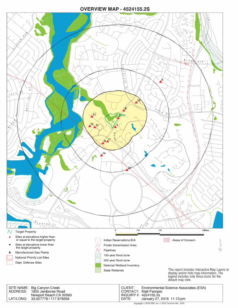
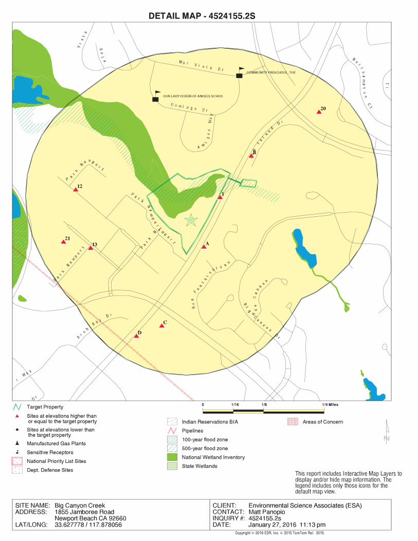
E27 FORD AEROSPACE & COM 1000 FORD ROAD CA ENVIROSTOR, CA SLIC, CA EMI, CA HWP Higher 2927, 0.554, NE
E26 LORAL AEROSPACE AERO FORD RD CERCLIS-NFRAP, CORRACTS, RCRA-TSDF, RCRA-SQG, US...Higher 2732, 0.517, NE
25 FOUR SEASONS HOTEL 690 NEWPORT CENTER RCRA-SQG, CA LUST, CA UST, CA SWEEPS UST, CA FID... Higher 2640, 0.500, SSE
24 NEWPORT BEACH POLICE 870 SANTA BARBARA DR CA LUST, CA CHMIRS, CA EMI, CA HIST CORTESE Higher 1734, 0.328, SSW
D23 LAND ROVER NEWPORT B 1540 JAMBOREE RD RCRA-SQG, CA LUST, CA UST, CA HIST UST, CA FID... Higher 1044, 0.198, SSW
D22 STERLING MOTORS LTD 1540 JAMBOREE RD CA SWEEPS UST Higher 1044, 0.198, SSW
21 NORTHCOTT WILLIAMS I 400 PARK NEWPORT #20 RCRA-SQG, FINDS Higher 1032, 0.195, West
20 FORD AERONUTRONIC 3000 FORD RD CA LUST, CA Orange Co. Industrial Site, CA HIST... Higher 1018, 0.193, NE
C19 1550 JAMBOREE RD EDR Hist Auto Higher 823, 0.156, SSW
C18 CHEVRON STATION NO 9 1550 JAMBOREE RD RCRA NonGen / NLR, FINDS, CA HAZNET Higher 823, 0.156, SSW
C17 CHEVRON #9-3042 1550 JAMBOREE RD CA FID UST, CA HIST CORTESE Higher 823, 0.156, SSW
C16 93042 1550 JAMBOREE RD CA HIST UST Higher 823, 0.156, SSW
C15 TERRIBLE HERBST INC 1550 JAMBOREE RD CA UST, CA SWEEPS UST Higher 823, 0.156, SSW
C14 CHEVRON #9-3042 1550 JAMBOREE CA LUST, CA HAZNET Higher 823, 0.156, SSW
13 2 PARK NEWPORT EDR Hist Cleaner Higher 797, 0.151, WSW
12 4810 PARK NEWPORT EDR Hist Auto Higher 777, 0.147, WNW
B11 1850 JAMBOREE RD CA AST Higher 268, 0.051, NE
B10 BIG CANYON COUNTRY C 1850 CA FID UST, CA HIST CORTESE Higher 268, 0.051, NE
B9 BIG CANYON COUNTRY C 1850 JAMBOREE RD CA LUST, CA UST, CA SWEEPS UST Higher 268, 0.051, NE
A8 TEXACO 1600 JAMBOREE RD CA UST Higher 118, 0.022, SSE
A7 TEXACO SERVICE STATI 1600 JAMBOREE RD CA LUST, CA HIST CORTESE Higher 118, 0.022, SSE
A6 SHELL OIL 1600 JAMBOREE CA LUST Higher 118, 0.022, SSE
A5 R & M PACIFIC ORO IN 1600 JAMBOREE RD CA UST Higher 118, 0.022, SSE
A4 SHELL SERVICE STATIO 1600 JAMBOREE RCRA-SQG, FINDS Higher 118, 0.022, SSE
A3 FASHION ISLAND SERVI 1600 JAMBOREE RD CA SWEEPS UST, CA FID UST Higher 118, 0.022, SSE
A2 1600 JAMBOREE RD EDR Hist Auto Higher 118, 0.022, SSE
1 1801 JAMBOREE RD EDR Hist Auto Higher 15, 0.003, NE
MAPPED SITES SUMMARY
Target Property Address:1855 JAMBOREE ROADNEWPORT BEACH, CA 92660
Click on Map ID to see full detail.
MAP RELATIVE DIST (ft. & mi.)ID DATABASE ACRONYMS ELEVATION DIRECTIONSITE NAME ADDRESS

EXECUTIVE SUMMARY
TC4524155.2s EXECUTIVE SUMMARY 3
TARGET PROPERTY SEARCH RESULTS
The target property was not listed in any of the databases searched by EDR.
DATABASES WITH NO MAPPED SITES
No mapped sites were found in EDR’s search of available ("reasonably ascertainable ") governmentrecords either on the target property or within the search radius around the target property for thefollowing databases:
STANDARD ENVIRONMENTAL RECORDS
Federal NPL site list
NPL National Priority ListProposed NPL Proposed National Priority List SitesNPL LIENS Federal Superfund Liens
Federal Delisted NPL site list
Delisted NPL National Priority List Deletions
Federal CERCLIS list
FEDERAL FACILITY Federal Facility Site Information listingCERCLIS Comprehensive Environmental Response, Compensation, and Liability Information System
Federal RCRA generators list
RCRA-LQG RCRA - Large Quantity GeneratorsRCRA-CESQG RCRA - Conditionally Exempt Small Quantity Generator
Federal institutional controls / engineering controls registries
LUCIS Land Use Control Information SystemUS ENG CONTROLS Engineering Controls Sites ListUS INST CONTROL Sites with Institutional Controls
Federal ERNS list
ERNS Emergency Response Notification System
State- and tribal - equivalent NPL
CA RESPONSE State Response Sites
State and tribal landfill and/or solid waste disposal site lists
CA SWF/LF Solid Waste Information System

EXECUTIVE SUMMARY
TC4524155.2s EXECUTIVE SUMMARY 4
State and tribal leaking storage tank lists
INDIAN LUST Leaking Underground Storage Tanks on Indian Land
State and tribal registered storage tank lists
FEMA UST Underground Storage Tank ListingINDIAN UST Underground Storage Tanks on Indian Land
State and tribal voluntary cleanup sites
CA VCP Voluntary Cleanup Program PropertiesINDIAN VCP Voluntary Cleanup Priority Listing
State and tribal Brownfields sites
CA BROWNFIELDS Considered Brownfieds Sites Listing
ADDITIONAL ENVIRONMENTAL RECORDS
Local Brownfield lists
US BROWNFIELDS A Listing of Brownfields Sites
Local Lists of Landfill / Solid Waste Disposal Sites
CA WMUDS/SWAT Waste Management Unit DatabaseCA SWRCY Recycler DatabaseCA HAULERS Registered Waste Tire Haulers ListingINDIAN ODI Report on the Status of Open Dumps on Indian LandsODI Open Dump InventoryDEBRIS REGION 9 Torres Martinez Reservation Illegal Dump Site Locations
Local Lists of Hazardous waste / Contaminated Sites
US HIST CDL National Clandestine Laboratory RegisterCA HIST Cal-Sites Historical Calsites DatabaseCA SCH School Property Evaluation ProgramCA CDL Clandestine Drug LabsCA Toxic Pits Toxic Pits Cleanup Act SitesUS CDL Clandestine Drug Labs
Local Land Records
CA LIENS Environmental Liens ListingLIENS 2 CERCLA Lien InformationCA DEED Deed Restriction Listing
Records of Emergency Release Reports
HMIRS Hazardous Materials Information Reporting SystemCA LDS Land Disposal Sites ListingCA MCS Military Cleanup Sites Listing
EXECUTIVE SUMMARY
TC4524155.2s EXECUTIVE SUMMARY 5
CA SPILLS 90 SPILLS 90 data from FirstSearch
Other Ascertainable Records
FUDS Formerly Used Defense SitesDOD Department of Defense SitesSCRD DRYCLEANERS State Coalition for Remediation of Drycleaners ListingEPA WATCH LIST EPA WATCH LISTTSCA Toxic Substances Control ActTRIS Toxic Chemical Release Inventory SystemSSTS Section 7 Tracking SystemsROD Records Of DecisionRMP Risk Management PlansRAATS RCRA Administrative Action Tracking SystemPRP Potentially Responsible PartiesICIS Integrated Compliance Information SystemFTTS FIFRA/ TSCA Tracking System - FIFRA (Federal Insecticide, Fungicide, & Rodenticide Act)/TSCA (Toxic Substances Control Act)MLTS Material Licensing Tracking SystemCOAL ASH DOE Steam-Electric Plant Operation DataCOAL ASH EPA Coal Combustion Residues Surface Impoundments ListPCB TRANSFORMER PCB Transformer Registration DatabaseRADINFO Radiation Information DatabaseHIST FTTS FIFRA/TSCA Tracking System Administrative Case ListingDOT OPS Incident and Accident DataCONSENT Superfund (CERCLA) Consent DecreesINDIAN RESERV Indian ReservationsUMTRA Uranium Mill Tailings SitesLEAD SMELTERS Lead Smelter SitesUS AIRS Aerometric Information Retrieval System Facility SubsystemUS MINES Mines Master Index FileCA BOND EXP. PLAN Bond Expenditure PlanCA Cortese "Cortese" Hazardous Waste & Substances Sites ListCA CUPA Listings CUPA Resources ListCA DRYCLEANERS Cleaner FacilitiesCA ENF Enforcement Action ListingCA Financial Assurance Financial Assurance Information ListingCA HWT Registered Hazardous Waste Transporter DatabaseCA MINES Mines Site Location ListingCA MWMP Medical Waste Management Program ListingCA NPDES NPDES Permits ListingCA PEST LIC Pesticide Regulation Licenses ListingCA PROC Certified Processors DatabaseCA Notify 65 Proposition 65 RecordsCA UIC UIC ListingCA WASTEWATER PITS Oil Wastewater Pits ListingCA WDS Waste Discharge SystemCA WIP Well Investigation Program Case List
EDR HIGH RISK HISTORICAL RECORDS
EDR Exclusive Records
EDR MGP EDR Proprietary Manufactured Gas Plants

EXECUTIVE SUMMARY
TC4524155.2s EXECUTIVE SUMMARY 6
EDR RECOVERED GOVERNMENT ARCHIVES
Exclusive Recovered Govt. Archives
CA RGA LF Recovered Government Archive Solid Waste Facilities ListCA RGA LUST Recovered Government Archive Leaking Underground Storage Tank
SURROUNDING SITES: SEARCH RESULTS
Surrounding sites were identified in the following databases.
Elevations have been determined from the USGS Digital Elevation Model and should be evaluated ona relative (not an absolute) basis. Relative elevation information between sites of close proximityshould be field verified. Sites with an elevation equal to or higher than the target property have beendifferentiated below from sites with an elevation lower than the target property.Page numbers and map identification numbers refer to the EDR Radius Map report where detaileddata on individual sites can be reviewed.
Sites listed in bold italics are in multiple databases.
Unmappable (orphan) sites are not considered in the foregoing analysis.
STANDARD ENVIRONMENTAL RECORDS
Federal RCRA CORRACTS facilities list
CORRACTS: CORRACTS is a list of handlers with RCRA Corrective Action Activity. This report showswhich nationally-defined corrective action core events have occurred for every handler that has had correctiveaction activity.
A review of the CORRACTS list, as provided by EDR, and dated 06/09/2015 has revealed that there is 1 CORRACTS site within approximately 1 mile of the target property.
PageMap IDDirection / Distance Address Equal/Higher Elevation ____________________ ________ ___________________ _____ _____
LORAL AEROSPACE AERO FORD RD NE 1/2 - 1 (0.517 mi.) E26 61
Federal RCRA generators list
RCRA-SQG: RCRAInfo is EPA’s comprehensive information system, providing access to data supportingthe Resource Conservation and Recovery Act (RCRA) of 1976 and the Hazardous and Solid Waste Amendments (HSWA)of 1984. The database includes selective information on sites which generate, transport, store, treat and/ordispose of hazardous waste as defined by the Resource Conservation and Recovery Act (RCRA). Small quantitygenerators (SQGs) generate between 100 kg and 1,000 kg of hazardous waste per month.
A review of the RCRA-SQG list, as provided by EDR, and dated 06/09/2015 has revealed that there are 3 RCRA-SQG sites within approximately 0.25 miles of the target property.
PageMap IDDirection / Distance Address Equal/Higher Elevation ____________________ ________ ___________________ _____ _____
SHELL SERVICE STATIO 1600 JAMBOREE SSE 0 - 1/8 (0.022 mi.) A4 12 NORTHCOTT WILLIAMS I 400 PARK NEWPORT #20 W 1/8 - 1/4 (0.195 mi.) 21 41 LAND ROVER NEWPORT B 1540 JAMBOREE RD SSW 1/8 - 1/4 (0.198 mi.) D23 43

EXECUTIVE SUMMARY
TC4524155.2s EXECUTIVE SUMMARY 7
State- and tribal - equivalent CERCLIS
CA ENVIROSTOR: The Department of Toxic Substances Control’s (DTSC’s) Site Mitigation and BrownfieldsReuse Program’s (SMBRP’s) EnviroStor database identifes sites that have known contamination or sites for whichthere may be reasons to investigate further. The database includes the following site types: FederalSuperfund sites (National Priorities List (NPL)); State Response, including Military Facilities and StateSuperfund; Voluntary Cleanup; and School sites. EnviroStor provides similar information to the informationthat was available in CalSites, and provides additional site information, including, but not limited to,identification of formerly-contaminated properties that have been released for reuse, properties whereenvironmental deed restrictions have been recorded to prevent inappropriate land uses, and riskcharacterization information that is used to assess potential impacts to public health and the environment atcontaminated sites.
A review of the CA ENVIROSTOR list, as provided by EDR, and dated 11/07/2015 has revealed that there is 1 CA ENVIROSTOR site within approximately 1 mile of the target property.
PageMap IDDirection / Distance Address Equal/Higher Elevation ____________________ ________ ___________________ _____ _____
FORD AEROSPACE & COM 1000 FORD ROAD NE 1/2 - 1 (0.554 mi.) E27 80Facility Id: 80001367Facility Id: 30370015Status: Refer: RWQCBStatus: Refer: RCRA
State and tribal leaking storage tank lists
CA LUST: The Leaking Underground Storage Tank Incident Reports contain an inventory of reportedleaking underground storage tank incidents. The data come from the State Water Resources Control Board LeakingUnderground Storage Tank Information System.
A review of the CA LUST list, as provided by EDR, and dated 10/21/2015 has revealed that there are 8 CA LUST sites within approximately 0.5 miles of the target property.
PageMap IDDirection / Distance Address Equal/Higher Elevation ____________________ ________ ___________________ _____ _____
SHELL OIL 1600 JAMBOREE SSE 0 - 1/8 (0.022 mi.) A6 14Facility Status: Case ClosedFacility Status: Pollution CharacterizationGlobal ID: T0605901252Global ID: T0605939328
TEXACO SERVICE STATI 1600 JAMBOREE RD SSE 0 - 1/8 (0.022 mi.) A7 16Global Id: T0605901252Global Id: T0605939328Current Status: 9Status: Completed - Case ClosedFacility Id: 90UT219Facility Id: 03UT021
BIG CANYON COUNTRY C 1850 JAMBOREE RD NE 0 - 1/8 (0.051 mi.) B9 22Facility Status: Case ClosedGlobal Id: T0605900051Current Status: 9Global ID: T0605900051Status: Completed - Case Closed

EXECUTIVE SUMMARY
TC4524155.2s EXECUTIVE SUMMARY 8
Facility Id: 86UT021
CHEVRON #9-3042 1550 JAMBOREE SSW 1/8 - 1/4 (0.156 mi.) C14 27Facility Status: Post remedial action monitoringGlobal Id: T0605900074Current Status: 9Global ID: T0605900074Status: Completed - Case ClosedFacility Id: 85UT032
FORD AERONUTRONIC 3000 FORD RD NE 1/8 - 1/4 (0.193 mi.) 20 38Facility Status: Pollution CharacterizationGlobal Id: T0605900841Global ID: T0605900841Status: Completed - Case Closed
LAND ROVER NEWPORT B 1540 JAMBOREE RD SSW 1/8 - 1/4 (0.198 mi.) D23 43Facility Status: Case ClosedGlobal Id: T0605902218Current Status: 9Global ID: T0605902218Status: Completed - Case ClosedFacility Id: 98UT102
NEWPORT BEACH POLICE 870 SANTA BARBARA DR SSW 1/4 - 1/2 (0.328 mi.) 24 48Facility Status: Case ClosedFacility Status: Preliminary site assessment underwayGlobal Id: T0605900840Global Id: T0605901955Current Status: 9Global ID: T0605900840Global ID: T0605901955Status: Completed - Case ClosedFacility Id: 88UT150Facility Id: 02UT019
FOUR SEASONS HOTEL 690 NEWPORT CENTER SSE 1/4 - 1/2 (0.500 mi.) 25 55Facility Status: Remediation PlanGlobal Id: T0605902093Current Status: 9Global ID: T0605902093Status: Completed - Case ClosedFacility Id: 97UT041
State and tribal registered storage tank lists
CA UST: The Underground Storage Tank database contains registered USTs. USTs are regulated underSubtitle I of the Resource Conservation and Recovery Act (RCRA). The data come from the State Water ResourcesControl Board’s Hazardous Substance Storage Container Database.
A review of the CA UST list, as provided by EDR, and dated 10/21/2015 has revealed that there are 5 CA UST sites within approximately 0.25 miles of the target property.
PageMap IDDirection / Distance Address Equal/Higher Elevation ____________________ ________ ___________________ _____ _____
R & M PACIFIC ORO IN 1600 JAMBOREE RD SSE 0 - 1/8 (0.022 mi.) A5 14
EXECUTIVE SUMMARY
TC4524155.2s EXECUTIVE SUMMARY 9
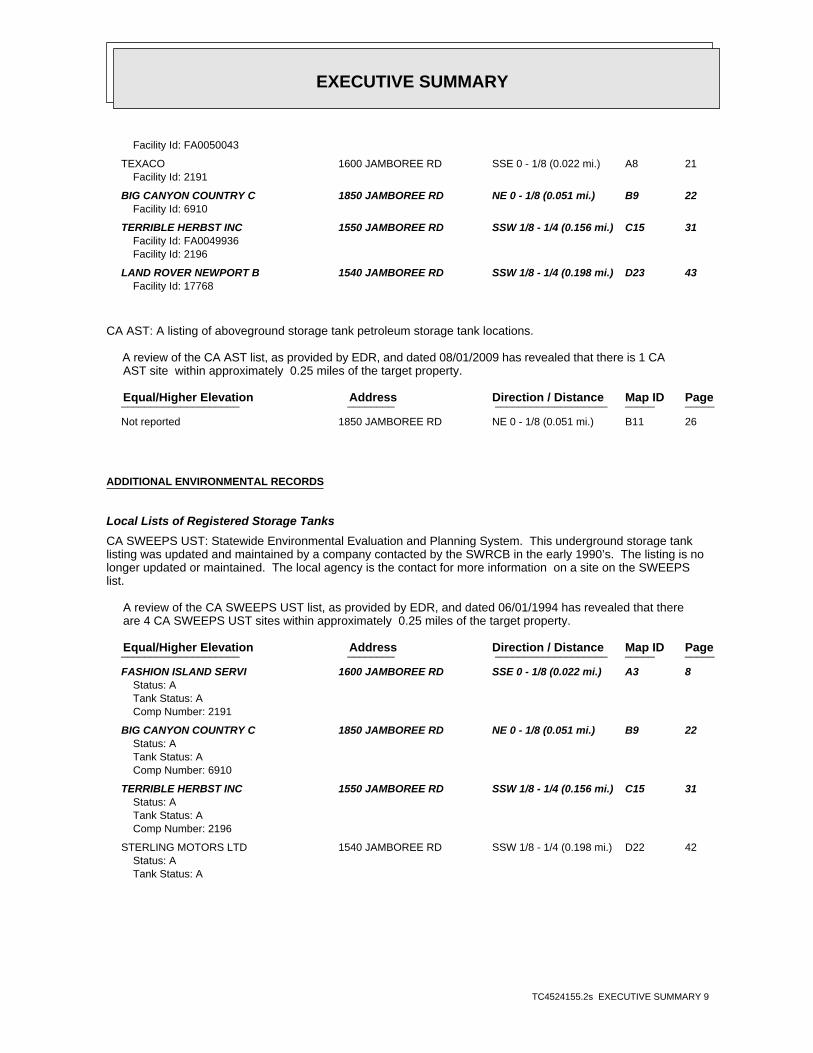
Facility Id: FA0050043
TEXACO 1600 JAMBOREE RD SSE 0 - 1/8 (0.022 mi.) A8 21Facility Id: 2191
BIG CANYON COUNTRY C 1850 JAMBOREE RD NE 0 - 1/8 (0.051 mi.) B9 22Facility Id: 6910
TERRIBLE HERBST INC 1550 JAMBOREE RD SSW 1/8 - 1/4 (0.156 mi.) C15 31Facility Id: FA0049936Facility Id: 2196
LAND ROVER NEWPORT B 1540 JAMBOREE RD SSW 1/8 - 1/4 (0.198 mi.) D23 43Facility Id: 17768
CA AST: A listing of aboveground storage tank petroleum storage tank locations.
A review of the CA AST list, as provided by EDR, and dated 08/01/2009 has revealed that there is 1 CA AST site within approximately 0.25 miles of the target property.
PageMap IDDirection / Distance Address Equal/Higher Elevation ____________________ ________ ___________________ _____ _____
Not reported 1850 JAMBOREE RD NE 0 - 1/8 (0.051 mi.) B11 26
ADDITIONAL ENVIRONMENTAL RECORDS
Local Lists of Registered Storage Tanks
CA SWEEPS UST: Statewide Environmental Evaluation and Planning System. This underground storage tanklisting was updated and maintained by a company contacted by the SWRCB in the early 1990’s. The listing is nolonger updated or maintained. The local agency is the contact for more information on a site on the SWEEPSlist.
A review of the CA SWEEPS UST list, as provided by EDR, and dated 06/01/1994 has revealed that there are 4 CA SWEEPS UST sites within approximately 0.25 miles of the target property.
PageMap IDDirection / Distance Address Equal/Higher Elevation ____________________ ________ ___________________ _____ _____
FASHION ISLAND SERVI 1600 JAMBOREE RD SSE 0 - 1/8 (0.022 mi.) A3 8Status: ATank Status: AComp Number: 2191
BIG CANYON COUNTRY C 1850 JAMBOREE RD NE 0 - 1/8 (0.051 mi.) B9 22Status: ATank Status: AComp Number: 6910
TERRIBLE HERBST INC 1550 JAMBOREE RD SSW 1/8 - 1/4 (0.156 mi.) C15 31Status: ATank Status: AComp Number: 2196
STERLING MOTORS LTD 1540 JAMBOREE RD SSW 1/8 - 1/4 (0.198 mi.) D22 42Status: ATank Status: A
EXECUTIVE SUMMARY
TC4524155.2s EXECUTIVE SUMMARY 10
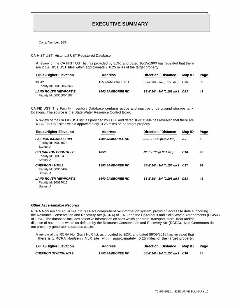
Comp Number: 1634
CA HIST UST: Historical UST Registered Database.
A review of the CA HIST UST list, as provided by EDR, and dated 10/15/1990 has revealed that there are 2 CA HIST UST sites within approximately 0.25 miles of the target property.
PageMap IDDirection / Distance Address Equal/Higher Elevation ____________________ ________ ___________________ _____ _____
93042 1550 JAMBOREE RD SSW 1/8 - 1/4 (0.156 mi.) C16 33Facility Id: 00000062368
LAND ROVER NEWPORT B 1540 JAMBOREE RD SSW 1/8 - 1/4 (0.198 mi.) D23 43Facility Id: 00000064597
CA FID UST: The Facility Inventory Database contains active and inactive underground storage tanklocations. The source is the State Water Resource Control Board.
A review of the CA FID UST list, as provided by EDR, and dated 10/31/1994 has revealed that there are 4 CA FID UST sites within approximately 0.25 miles of the target property.
PageMap IDDirection / Distance Address Equal/Higher Elevation ____________________ ________ ___________________ _____ _____
FASHION ISLAND SERVI 1600 JAMBOREE RD SSE 0 - 1/8 (0.022 mi.) A3 8Facility Id: 30001074Status: A
BIG CANYON COUNTRY C 1850 NE 0 - 1/8 (0.051 mi.) B10 25Facility Id: 30000419Status: A
CHEVRON #9-3042 1550 JAMBOREE RD SSW 1/8 - 1/4 (0.156 mi.) C17 34Facility Id: 30000489Status: A
LAND ROVER NEWPORT B 1540 JAMBOREE RD SSW 1/8 - 1/4 (0.198 mi.) D23 43Facility Id: 30017016Status: A
Other Ascertainable Records
RCRA NonGen / NLR: RCRAInfo is EPA’s comprehensive information system, providing access to data supportingthe Resource Conservation and Recovery Act (RCRA) of 1976 and the Hazardous and Solid Waste Amendments (HSWA)of 1984. The database includes selective information on sites which generate, transport, store, treat and/ordispose of hazardous waste as defined by the Resource Conservation and Recovery Act (RCRA). Non-Generators donot presently generate hazardous waste.
A review of the RCRA NonGen / NLR list, as provided by EDR, and dated 06/09/2015 has revealed that there is 1 RCRA NonGen / NLR site within approximately 0.25 miles of the target property.
PageMap IDDirection / Distance Address Equal/Higher Elevation ____________________ ________ ___________________ _____ _____
CHEVRON STATION NO 9 1550 JAMBOREE RD SSW 1/8 - 1/4 (0.156 mi.) C18 35
EXECUTIVE SUMMARY
TC4524155.2s EXECUTIVE SUMMARY 11
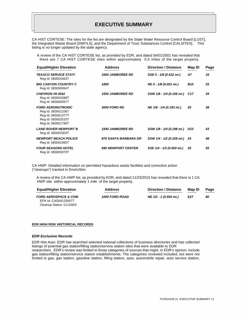
CA HIST CORTESE: The sites for the list are designated by the State Water Resource Control Board [LUST],the Integrated Waste Board [SWF/LS], and the Department of Toxic Substances Control [CALSITES]. Thislisting is no longer updated by the state agency.
A review of the CA HIST CORTESE list, as provided by EDR, and dated 04/01/2001 has revealed that there are 7 CA HIST CORTESE sites within approximately 0.5 miles of the target property.
PageMap IDDirection / Distance Address Equal/Higher Elevation ____________________ ________ ___________________ _____ _____
TEXACO SERVICE STATI 1600 JAMBOREE RD SSE 0 - 1/8 (0.022 mi.) A7 16Reg Id: 083001663T
BIG CANYON COUNTRY C 1850 NE 0 - 1/8 (0.051 mi.) B10 25Reg Id: 083000064T
CHEVRON #9-3042 1550 JAMBOREE RD SSW 1/8 - 1/4 (0.156 mi.) C17 34Reg Id: 083002288TReg Id: 083000097T
FORD AERONUTRONIC 3000 FORD RD NE 1/8 - 1/4 (0.193 mi.) 20 38Reg Id: 083001106TReg Id: 083001377TReg Id: 083002510TReg Id: 083001795T
LAND ROVER NEWPORT B 1540 JAMBOREE RD SSW 1/8 - 1/4 (0.198 mi.) D23 43Reg Id: 083003303T
NEWPORT BEACH POLICE 870 SANTA BARBARA DR SSW 1/4 - 1/2 (0.328 mi.) 24 48Reg Id: 083001065T
FOUR SEASONS HOTEL 690 NEWPORT CENTER SSE 1/4 - 1/2 (0.500 mi.) 25 55Reg Id: 083003073T
CA HWP: Detailed information on permitted hazardous waste facilities and corrective action("cleanups") tracked in EnviroStor.
A review of the CA HWP list, as provided by EDR, and dated 11/23/2015 has revealed that there is 1 CA HWP site within approximately 1 mile of the target property.
PageMap IDDirection / Distance Address Equal/Higher Elevation ____________________ ________ ___________________ _____ _____
FORD AEROSPACE & COM 1000 FORD ROAD NE 1/2 - 1 (0.554 mi.) E27 80EPA Id: CAD041330077Cleanup Status: CLOSED
EDR HIGH RISK HISTORICAL RECORDS
EDR Exclusive Records
EDR Hist Auto: EDR has searched selected national collections of business directories and has collectedlistings of potential gas station/filling station/service station sites that were available to EDRresearchers. EDR’s review was limited to those categories of sources that might, in EDR’s opinion, includegas station/filling station/service station establishments. The categories reviewed included, but were notlimited to gas, gas station, gasoline station, filling station, auto, automobile repair, auto service station,

EXECUTIVE SUMMARY
TC4524155.2s EXECUTIVE SUMMARY 12
service station, etc. This database falls within a category of information EDR classifies as "High RiskHistorical Records", or HRHR. EDR’s HRHR effort presents unique and sometimes proprietary data about pastsites and operations that typically create environmental concerns, but may not show up in current governmentrecords searches.
A review of the EDR Hist Auto list, as provided by EDR, has revealed that there are 4 EDR Hist Auto sites within approximately 0.25 miles of the target property.
PageMap IDDirection / Distance Address Equal/Higher Elevation ____________________ ________ ___________________ _____ _____
Not reported 1801 JAMBOREE RD NE 0 - 1/8 (0.003 mi.) 1 8 Not reported 1600 JAMBOREE RD SSE 0 - 1/8 (0.022 mi.) A2 8 Not reported 4810 PARK NEWPORT WNW 1/8 - 1/4 (0.147 mi.) 12 26 Not reported 1550 JAMBOREE RD SSW 1/8 - 1/4 (0.156 mi.) C19 37
EDR Hist Cleaner: EDR has searched selected national collections of business directories and has collectedlistings of potential dry cleaner sites that were available to EDR researchers. EDR’s review was limited tothose categories of sources that might, in EDR’s opinion, include dry cleaning establishments. The categoriesreviewed included, but were not limited to dry cleaners, cleaners, laundry, laundromat, cleaning/laundry, wash& dry etc. This database falls within a category of information EDR classifies as "High Risk HistoricalRecords", or HRHR. EDR’s HRHR effort presents unique and sometimes proprietary data about past sites andoperations that typically create environmental concerns, but may not show up in current government recordssearches.
A review of the EDR Hist Cleaner list, as provided by EDR, has revealed that there is 1 EDR Hist Cleaner site within approximately 0.25 miles of the target property.
PageMap IDDirection / Distance Address Equal/Higher Elevation ____________________ ________ ___________________ _____ _____
Not reported 2 PARK NEWPORT WSW 1/8 - 1/4 (0.151 mi.) 13 26
EXECUTIVE SUMMARY
TC4524155.2s EXECUTIVE SUMMARY 13
There were no unmapped sites in this report.
EDR Inc.EDR Inc.EDR Inc.EDR Inc.EDR Inc.EDR Inc.EDR Inc.EDR Inc.EDR Inc.EDR Inc.EDR Inc.EDR Inc.EDR Inc.EDR Inc.EDR Inc.EDR Inc.EDR Inc.EDR Inc.EDR Inc.EDR Inc.EDR Inc.EDR Inc.EDR Inc.EDR Inc.EDR Inc.EDR Inc.EDR Inc.EDR Inc.EDR Inc.EDR Inc.EDR Inc.EDR Inc.EDR Inc.EDR Inc.EDR Inc.EDR Inc.EDR Inc.EDR Inc.EDR Inc.EDR Inc.
60 kV
1 2 0
12
0
80
80
8 0
80
4 0
40
40
40
4 0
4 0
8 0
80
1 2 0 16
0
120
120
404 0
80
80
8 0
12
02 0 0
20
0
20
0
12
0
12
0
12
0
1 2 0
2 0 0
2 0 0
200
2 0 020 0
200
16
01
20
80
80
1 2 0
12
0
16
0
16
0
160
1 6 0
1 6 0
1 6 0
16
0
2 0 02
0 02 0 0
80
40
20
016
0
16
0
12
0
12
0
8 0
8 0
40
4 0
8
0 2 00
2 0 080
20
0
2 0 0
80
2 0 0
160
2 0 0
2
00
200
1 2 0
1
2 0
20
020
0
2 0 0
20
0
1
6 0 1 6 0
1 6 0
16
0
20
0
2 0 0
2 0 02 0 0
200
20
0
20
0
0
200
28
0
2
24
0
24
0
24
0
240
EDR Inc.EDR Inc.EDR Inc.EDR Inc.EDR Inc.EDR Inc.EDR Inc.EDR Inc.EDR Inc.EDR Inc.EDR Inc.EDR Inc.EDR Inc.EDR Inc.EDR Inc.EDR Inc.EDR Inc.EDR Inc.EDR Inc.EDR Inc.EDR Inc.EDR Inc.EDR Inc.EDR Inc.EDR Inc.EDR Inc.EDR Inc.EDR Inc.EDR Inc.EDR Inc.EDR Inc.EDR Inc.EDR Inc.EDR Inc.EDR Inc.EDR Inc.EDR Inc.EDR Inc.EDR Inc.EDR Inc.
120
1
2 0
80
40
0
80
120
1
6 0
1 20
20
20
0
200
20
0
20
0160
120
8080
120
200
80
200
80
200
20
0
120160
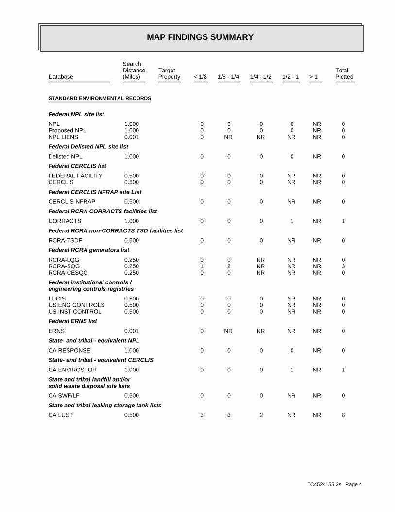
MAP FINDINGS SUMMARY
SearchTargetDistance Total
Database Property(Miles) < 1/8 1/8 - 1/4 1/4 - 1/2 1/2 - 1 > 1 Plotted
STANDARD ENVIRONMENTAL RECORDS
Federal NPL site list
0 NR 0 0 0 0 1.000NPL 0 NR 0 0 0 0 1.000Proposed NPL 0 NR NR NR NR 0 0.001NPL LIENS
Federal Delisted NPL site list
0 NR 0 0 0 0 1.000Delisted NPL
Federal CERCLIS list
0 NR NR 0 0 0 0.500FEDERAL FACILITY 0 NR NR 0 0 0 0.500CERCLIS
Federal CERCLIS NFRAP site List
0 NR NR 0 0 0 0.500CERCLIS-NFRAP
Federal RCRA CORRACTS facilities list
1 NR 1 0 0 0 1.000CORRACTS
Federal RCRA non-CORRACTS TSD facilities list
0 NR NR 0 0 0 0.500RCRA-TSDF
Federal RCRA generators list
0 NR NR NR 0 0 0.250RCRA-LQG 3 NR NR NR 2 1 0.250RCRA-SQG 0 NR NR NR 0 0 0.250RCRA-CESQG
Federal institutional controls /engineering controls registries
0 NR NR 0 0 0 0.500LUCIS 0 NR NR 0 0 0 0.500US ENG CONTROLS 0 NR NR 0 0 0 0.500US INST CONTROL
Federal ERNS list
0 NR NR NR NR 0 0.001ERNS
State- and tribal - equivalent NPL
0 NR 0 0 0 0 1.000CA RESPONSE
State- and tribal - equivalent CERCLIS
1 NR 1 0 0 0 1.000CA ENVIROSTOR
State and tribal landfill and/orsolid waste disposal site lists
0 NR NR 0 0 0 0.500CA SWF/LF
State and tribal leaking storage tank lists
8 NR NR 2 3 3 0.500CA LUST
TC4524155.2s Page 4

MAP FINDINGS SUMMARY
SearchTargetDistance Total
Database Property(Miles) < 1/8 1/8 - 1/4 1/4 - 1/2 1/2 - 1 > 1 Plotted
0 NR NR 0 0 0 0.500INDIAN LUST 0 NR NR 0 0 0 0.500CA SLIC
State and tribal registered storage tank lists
0 NR NR NR 0 0 0.250FEMA UST 5 NR NR NR 2 3 0.250CA UST 1 NR NR NR 0 1 0.250CA AST 0 NR NR NR 0 0 0.250INDIAN UST
State and tribal voluntary cleanup sites
0 NR NR 0 0 0 0.500CA VCP 0 NR NR 0 0 0 0.500INDIAN VCP
State and tribal Brownfields sites
0 NR NR 0 0 0 0.500CA BROWNFIELDS
ADDITIONAL ENVIRONMENTAL RECORDS
Local Brownfield lists
0 NR NR 0 0 0 0.500US BROWNFIELDS
Local Lists of Landfill / SolidWaste Disposal Sites
0 NR NR 0 0 0 0.500CA WMUDS/SWAT 0 NR NR 0 0 0 0.500CA SWRCY 0 NR NR NR NR 0 0.001CA HAULERS 0 NR NR 0 0 0 0.500INDIAN ODI 0 NR NR 0 0 0 0.500ODI 0 NR NR 0 0 0 0.500DEBRIS REGION 9
Local Lists of Hazardous waste /Contaminated Sites
0 NR NR NR NR 0 0.001US HIST CDL 0 NR 0 0 0 0 1.000CA HIST Cal-Sites 0 NR NR NR 0 0 0.250CA SCH 0 NR NR NR NR 0 0.001CA CDL 0 NR 0 0 0 0 1.000CA Toxic Pits 0 NR NR NR NR 0 0.001US CDL
Local Lists of Registered Storage Tanks
4 NR NR NR 2 2 0.250CA SWEEPS UST 2 NR NR NR 2 0 0.250CA HIST UST 4 NR NR NR 2 2 0.250CA FID UST
Local Land Records
0 NR NR NR NR 0 0.001CA LIENS 0 NR NR NR NR 0 0.001LIENS 2 0 NR NR 0 0 0 0.500CA DEED
Records of Emergency Release Reports
0 NR NR NR NR 0 0.001HMIRS
TC4524155.2s Page 5

MAP FINDINGS SUMMARY
SearchTargetDistance Total
Database Property(Miles) < 1/8 1/8 - 1/4 1/4 - 1/2 1/2 - 1 > 1 Plotted
0 NR NR NR NR 0 0.001CA CHMIRS 0 NR NR NR NR 0 0.001CA LDS 0 NR NR NR NR 0 0.001CA MCS 0 NR NR NR NR 0 0.001CA Orange Co. Industrial Site 0 NR NR NR NR 0 0.001CA SPILLS 90
Other Ascertainable Records
1 NR NR NR 1 0 0.250RCRA NonGen / NLR 0 NR 0 0 0 0 1.000FUDS 0 NR 0 0 0 0 1.000DOD 0 NR NR 0 0 0 0.500SCRD DRYCLEANERS 0 NR NR NR NR 0 0.001US FIN ASSUR 0 NR NR NR NR 0 0.001EPA WATCH LIST 0 NR NR NR 0 0 0.2502020 COR ACTION 0 NR NR NR NR 0 0.001TSCA 0 NR NR NR NR 0 0.001TRIS 0 NR NR NR NR 0 0.001SSTS 0 NR 0 0 0 0 1.000ROD 0 NR NR NR NR 0 0.001RMP 0 NR NR NR NR 0 0.001RAATS 0 NR NR NR NR 0 0.001PRP 0 NR NR NR NR 0 0.001PADS 0 NR NR NR NR 0 0.001ICIS 0 NR NR NR NR 0 0.001FTTS 0 NR NR NR NR 0 0.001MLTS 0 NR NR NR NR 0 0.001COAL ASH DOE 0 NR NR 0 0 0 0.500COAL ASH EPA 0 NR NR NR NR 0 0.001PCB TRANSFORMER 0 NR NR NR NR 0 0.001RADINFO 0 NR NR NR NR 0 0.001HIST FTTS 0 NR NR NR NR 0 0.001DOT OPS 0 NR 0 0 0 0 1.000CONSENT 0 NR NR NR NR 0 0.001INDIAN RESERV 0 NR NR 0 0 0 0.500UMTRA 0 NR NR NR NR 0 0.001LEAD SMELTERS 0 NR NR NR NR 0 0.001US AIRS 0 NR NR NR 0 0 0.250US MINES 0 NR NR NR NR 0 0.001FINDS 0 NR 0 0 0 0 1.000CA BOND EXP. PLAN 0 NR NR 0 0 0 0.500CA Cortese 0 NR NR NR 0 0 0.250CA CUPA Listings 0 NR NR NR 0 0 0.250CA DRYCLEANERS 0 NR NR NR NR 0 0.001CA EMI 0 NR NR NR NR 0 0.001CA ENF 0 NR NR NR NR 0 0.001CA Financial Assurance 0 NR NR NR NR 0 0.001CA HAZNET 7 NR NR 2 3 2 0.500CA HIST CORTESE 1 NR 1 0 0 0 1.000CA HWP 0 NR NR NR 0 0 0.250CA HWT 0 NR NR NR 0 0 0.250NY MANIFEST 0 NR NR NR NR 0 0.001CA MINES
TC4524155.2s Page 6

MAP FINDINGS SUMMARY
SearchTargetDistance Total
Database Property(Miles) < 1/8 1/8 - 1/4 1/4 - 1/2 1/2 - 1 > 1 Plotted
0 NR NR NR 0 0 0.250CA MWMP 0 NR NR NR NR 0 0.001CA NPDES 0 NR NR NR NR 0 0.001CA PEST LIC 0 NR NR 0 0 0 0.500CA PROC 0 NR 0 0 0 0 1.000CA Notify 65 0 NR NR NR NR 0 0.001CA UIC 0 NR NR 0 0 0 0.500CA WASTEWATER PITS 0 NR NR NR NR 0 0.001CA WDS 0 NR NR NR 0 0 0.250CA WIP
EDR HIGH RISK HISTORICAL RECORDS
EDR Exclusive Records
0 NR 0 0 0 0 1.000EDR MGP 4 NR NR NR 2 2 0.250EDR Hist Auto 1 NR NR NR 1 0 0.250EDR Hist Cleaner
EDR RECOVERED GOVERNMENT ARCHIVES
Exclusive Recovered Govt. Archives
0 NR NR NR NR 0 0.001CA RGA LF 0 NR NR NR NR 0 0.001CA RGA LUST
43 0 3 4 20 16 0- Totals --
NOTES:
TP = Target Property
NR = Not Requested at this Search Distance
Sites may be listed in more than one database
TC4524155.2s Page 7

MAP FINDINGSMap IDDirection
EDR ID NumberDistanceEPA ID NumberDatabase(s)SiteElevation
1801 JAMBOREE RDAddress: 1999Year: CHEVRON STATIONS NEWPORT BEACHName:
EDR Historical Auto Stations:
15 ft.0.003 mi.
Relative:Higher
Actual:54 ft.
< 1/8 NEWPORT BEACH, CA 92660NE 1801 JAMBOREE RD N/A1 EDR Hist Auto 1015278245
1600 JAMBOREE RDAddress: 2003Year: SHELL SERVICE STATIONName:
1600 JAMBOREE RDAddress: 2002Year: SHELL SERVICE STATIONName:
1600 JAMBOREE RDAddress: 1999Year: TEXACO SERVICE STN DLRS NEWPORT BEACHName:
EDR Historical Auto Stations:
118 ft. Site 1 of 7 in cluster A0.022 mi.
Relative:Higher
Actual:78 ft.
< 1/8 NEWPORT BEACH, CA 92660SSE 1600 JAMBOREE RD N/AA2 EDR Hist Auto 1015252308
44-015928Board Of Equalization: Not reportedNumber: 2191Comp Number: Not reportedStatus:
5Number Of Tanks: Not reportedContent: PRODUCTSTG: UNKNOWNTank Use: Not reportedActive Date: 500Capacity: Not reportedTank Status: 30-000-002191-000001SWRCB Tank Id: Not reportedOwner Tank Id: Not reportedCreated Date: Not reportedAction Date: Not reportedReferral Date: 44-015928Board Of Equalization: Not reportedNumber: 2191Comp Number: Not reportedStatus:
SWEEPS UST:
118 ft. Site 2 of 7 in cluster A0.022 mi.
Relative:Higher
Actual:78 ft.
< 1/8 NEWPORT BEACH, CA 92660SSE CA FID UST1600 JAMBOREE RD N/AA3 CA SWEEPS USTFASHION ISLAND SERVICES INC TE S101589039
TC4524155.2s Page 8

MAP FINDINGSMap IDDirection
EDR ID NumberDistanceEPA ID NumberDatabase(s)SiteElevation
Not reportedTank Status: 30-000-002191-000008SWRCB Tank Id: Not reportedOwner Tank Id: Not reportedCreated Date: Not reportedAction Date: Not reportedReferral Date: 44-015928Board Of Equalization: Not reportedNumber: 2191Comp Number: Not reportedStatus:
Not reportedNumber Of Tanks: Not reportedContent: PRODUCTSTG: UNKNOWNTank Use: Not reportedActive Date: 8000Capacity: Not reportedTank Status: 30-000-002191-000007SWRCB Tank Id: Not reportedOwner Tank Id: Not reportedCreated Date: Not reportedAction Date: Not reportedReferral Date: 44-015928Board Of Equalization: Not reportedNumber: 2191Comp Number: Not reportedStatus:
Not reportedNumber Of Tanks: Not reportedContent: PRODUCTSTG: UNKNOWNTank Use: Not reportedActive Date: 8000Capacity: Not reportedTank Status: 30-000-002191-000006SWRCB Tank Id: Not reportedOwner Tank Id: Not reportedCreated Date: Not reportedAction Date: Not reportedReferral Date: 44-015928Board Of Equalization: Not reportedNumber: 2191Comp Number: Not reportedStatus:
Not reportedNumber Of Tanks: Not reportedContent: PRODUCTSTG: UNKNOWNTank Use: Not reportedActive Date: 8000Capacity: Not reportedTank Status: 30-000-002191-000005SWRCB Tank Id: Not reportedOwner Tank Id: Not reportedCreated Date: Not reportedAction Date: Not reportedReferral Date:
FASHION ISLAND SERVICES INC TE (Continued) S101589039
TC4524155.2s Page 9

MAP FINDINGSMap IDDirection
EDR ID NumberDistanceEPA ID NumberDatabase(s)SiteElevation
Not reportedNumber Of Tanks: DIESELContent: PSTG: M.V. FUELTank Use: Not reportedActive Date: 10000Capacity: ATank Status: 30-000-002191-000012SWRCB Tank Id: Not reportedOwner Tank Id: 02-29-88Created Date: 09-15-92Action Date: 09-30-92Referral Date: 44-015928Board Of Equalization: 9Number: 2191Comp Number: ActiveStatus:
Not reportedNumber Of Tanks: REG UNLEADEDContent: PSTG: M.V. FUELTank Use: Not reportedActive Date: 10000Capacity: ATank Status: 30-000-002191-000011SWRCB Tank Id: Not reportedOwner Tank Id: 02-29-88Created Date: 09-15-92Action Date: 09-30-92Referral Date: 44-015928Board Of Equalization: 9Number: 2191Comp Number: ActiveStatus:
5Number Of Tanks: REG UNLEADEDContent: PSTG: M.V. FUELTank Use: Not reportedActive Date: 10000Capacity: ATank Status: 30-000-002191-000010SWRCB Tank Id: Not reportedOwner Tank Id: 02-29-88Created Date: 09-15-92Action Date: 09-30-92Referral Date: 44-015928Board Of Equalization: 9Number: 2191Comp Number: ActiveStatus:
Not reportedNumber Of Tanks: Not reportedContent: PRODUCTSTG: UNKNOWNTank Use: Not reportedActive Date: 10000Capacity:
FASHION ISLAND SERVICES INC TE (Continued) S101589039
TC4524155.2s Page 10

MAP FINDINGSMap IDDirection
EDR ID NumberDistanceEPA ID NumberDatabase(s)SiteElevation
ActiveStatus: Not reportedComments: Not reportedEPA ID: Not reportedNPDES Number: Not reportedDUNs Number: Not reportedContact Phone: Not reportedContact: NEWPORT BEACH 92660Mailing City,St,Zip: Not reportedMailing Address 2: 3631 HBR BLVD STE 225 PAUMailing Address: Not reportedMail To: 8185052480Facility Phone: Not reportedSIC Code: Not reportedCortese Code: Not reportedRegulated ID: UTNKARegulated By: 30001074Facility ID:
CA FID UST:
Not reportedNumber Of Tanks: Not reportedContent: PSTG: PETROLEUMTank Use: Not reportedActive Date: 550Capacity: ATank Status: 30-000-002191-000014SWRCB Tank Id: Not reportedOwner Tank Id: 02-29-88Created Date: 09-15-92Action Date: 09-30-92Referral Date: 44-015928Board Of Equalization: 9Number: 2191Comp Number: ActiveStatus:
Not reportedNumber Of Tanks: DIESELContent: PSTG: M.V. FUELTank Use: Not reportedActive Date: 10000Capacity: ATank Status: 30-000-002191-000013SWRCB Tank Id: Not reportedOwner Tank Id: 02-29-88Created Date: 09-15-92Action Date: 09-30-92Referral Date: 44-015928Board Of Equalization: 9Number: 2191Comp Number: ActiveStatus:
FASHION ISLAND SERVICES INC TE (Continued) S101589039
TC4524155.2s Page 11
MAP FINDINGSMap IDDirection
EDR ID NumberDistanceEPA ID NumberDatabase(s)SiteElevation
Not reportedOwner/Op start date: OwnerOwner/Operator Type: PrivateLegal status: (713) 241-5036Owner/operator telephone: Not reportedOwner/operator country: HOUSTON, TX 77252 P O BOX 2648Owner/operator address: EQUILON ENTERPRISES L L COwner/operator name:
Not reportedOwner/Op end date: 08/01/1998Owner/Op start date: OwnerOwner/Operator Type: PrivateLegal status: Not reportedOwner/operator telephone: USOwner/operator country: HOUSTON, TX 77252 PO BOX 2648Owner/operator address: EQUILON ENTERPRISES LLC DBA SHELL OIL PROwner/operator name:
Not reportedOwner/Op end date: 08/01/1998Owner/Op start date: OperatorOwner/Operator Type: PrivateLegal status: Not reportedOwner/operator telephone: USOwner/operator country: Not reported Not reportedOwner/operator address: SHELL OIL PRODUCTS USOwner/operator name:
Owner/Operator Summary:
hazardous waste at any time waste during any calendar month, and accumulates more than 1000 kg of hazardous waste at any time; or generates 100 kg or less of hazardous waste during any calendar month and accumulates less than 6000 kg of Handler: generates more than 100 and less than 1000 kg of hazardousDescription: Small Small Quantity GeneratorClassification: 09EPA Region: [email protected] email: (714) 731-8337Contact telephone: USContact country: Not reported Not reportedContact address: GARY V WINGContact: HOUSTON, TX 770672508 12700 NORTHBOROUGH DR MFT240G SHELL OIL PRODUCTS USMailing address: CAD983663865EPA ID: NEWPORT BEACH, CA 92660 SAP #120718 1600 JAMBOREEFacility address: SHELL SERVICE STATIONFacility name: 02/26/2004Date form received by agency:
RCRA-SQG:
118 ft. Site 3 of 7 in cluster A0.022 mi.
Relative:Higher
Actual:78 ft.
< 1/8 NEWPORT BEACH, CA 92660SSE FINDS1600 JAMBOREE CAD983663865A4 RCRA-SQGSHELL SERVICE STATION 1000820352
TC4524155.2s Page 12
MAP FINDINGSMap IDDirection
EDR ID NumberDistanceEPA ID NumberDatabase(s)SiteElevation
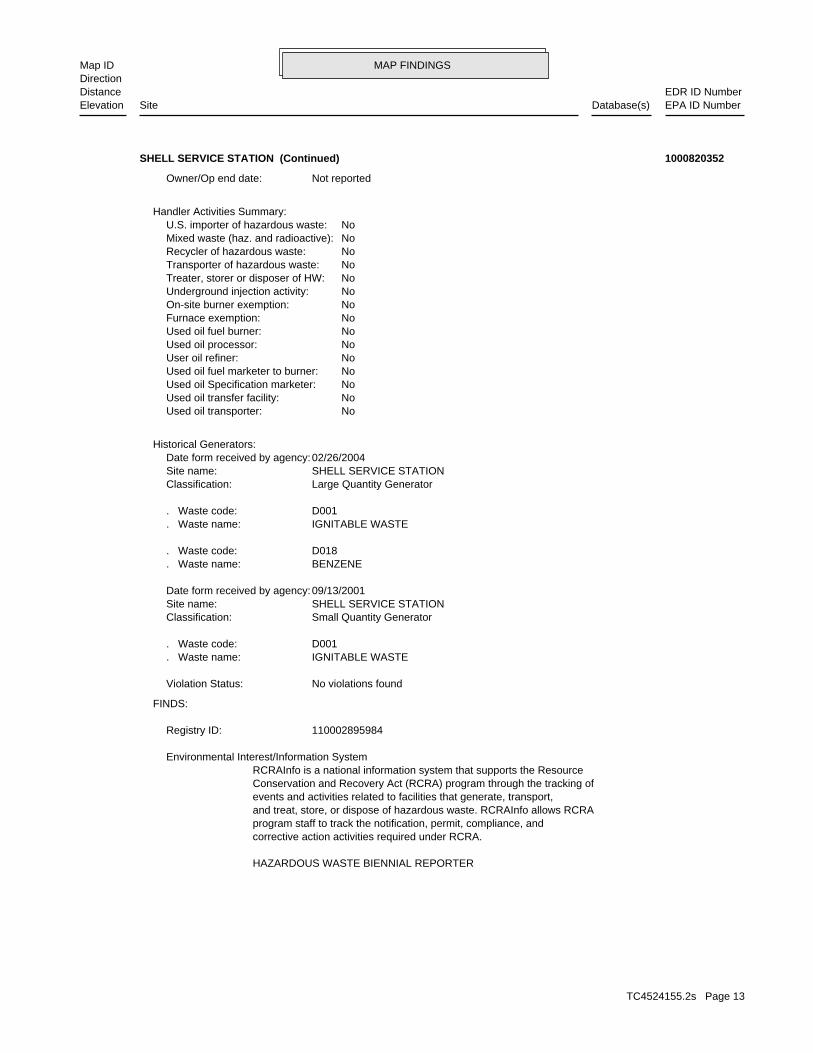
HAZARDOUS WASTE BIENNIAL REPORTER
corrective action activities required under RCRA.program staff to track the notification, permit, compliance, andand treat, store, or dispose of hazardous waste. RCRAInfo allows RCRAevents and activities related to facilities that generate, transport,Conservation and Recovery Act (RCRA) program through the tracking ofRCRAInfo is a national information system that supports the Resource Environmental Interest/Information System
110002895984Registry ID:
FINDS:
No violations foundViolation Status:
IGNITABLE WASTE. Waste name: D001. Waste code:
Small Quantity GeneratorClassification: SHELL SERVICE STATIONSite name: 09/13/2001Date form received by agency:
BENZENE. Waste name: D018. Waste code:
IGNITABLE WASTE. Waste name: D001. Waste code:
Large Quantity GeneratorClassification: SHELL SERVICE STATIONSite name: 02/26/2004Date form received by agency:
Historical Generators:
NoUsed oil transporter: NoUsed oil transfer facility: NoUsed oil Specification marketer: NoUsed oil fuel marketer to burner: NoUser oil refiner: NoUsed oil processor: NoUsed oil fuel burner: NoFurnace exemption: NoOn-site burner exemption: NoUnderground injection activity: NoTreater, storer or disposer of HW: NoTransporter of hazardous waste: NoRecycler of hazardous waste: NoMixed waste (haz. and radioactive): NoU.S. importer of hazardous waste:
Handler Activities Summary:
Not reportedOwner/Op end date:
SHELL SERVICE STATION (Continued) 1000820352
TC4524155.2s Page 13
MAP FINDINGSMap IDDirection
EDR ID NumberDistanceEPA ID NumberDatabase(s)SiteElevation
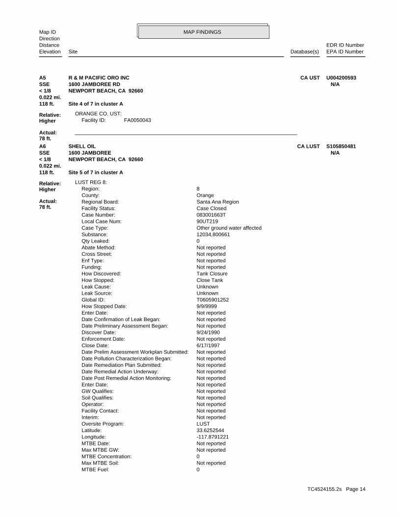
FA0050043Facility ID:ORANGE CO. UST:
118 ft. Site 4 of 7 in cluster A0.022 mi.
Relative:Higher
Actual:78 ft.
< 1/8 NEWPORT BEACH, CA 92660SSE 1600 JAMBOREE RD N/AA5 CA USTR & M PACIFIC ORO INC U004200593
0MTBE Fuel: Not reportedMax MTBE Soil: 0MTBE Concentration: Not reportedMax MTBE GW: Not reportedMTBE Date: -117.8791221Longitude: 33.6252544Latitude: LUSTOversite Program: Not reportedInterim: Not reportedFacility Contact: Not reportedOperator: Not reportedSoil Qualifies: Not reportedGW Qualifies: Not reportedEnter Date: Not reportedDate Post Remedial Action Monitoring: Not reportedDate Remedial Action Underway: Not reportedDate Remediation Plan Submitted: Not reportedDate Pollution Characterization Began: Not reportedDate Prelim Assessment Workplan Submitted: 6/17/1997Close Date: Not reportedEnforcement Date: 9/24/1990Discover Date: Not reportedDate Preliminary Assessment Began: Not reportedDate Confirmation of Leak Began: Not reportedEnter Date: 9/9/9999How Stopped Date: T0605901252Global ID: UnknownLeak Source: UnknownLeak Cause: Close TankHow Stopped: Tank ClosureHow Discovered: Not reportedFunding: Not reportedEnf Type: Not reportedCross Street: Not reportedAbate Method: 0Qty Leaked: 12034,800661Substance: Other ground water affectedCase Type: 90UT219Local Case Num: 083001663TCase Number: Case ClosedFacility Status: Santa Ana RegionRegional Board: OrangeCounty: 8Region:
LUST REG 8:
118 ft. Site 5 of 7 in cluster A0.022 mi.
Relative:Higher
Actual:78 ft.
< 1/8 NEWPORT BEACH, CA 92660SSE 1600 JAMBOREE N/AA6 CA LUSTSHELL OIL S105850481
TC4524155.2s Page 14
MAP FINDINGSMap IDDirection
EDR ID NumberDistanceEPA ID NumberDatabase(s)SiteElevation
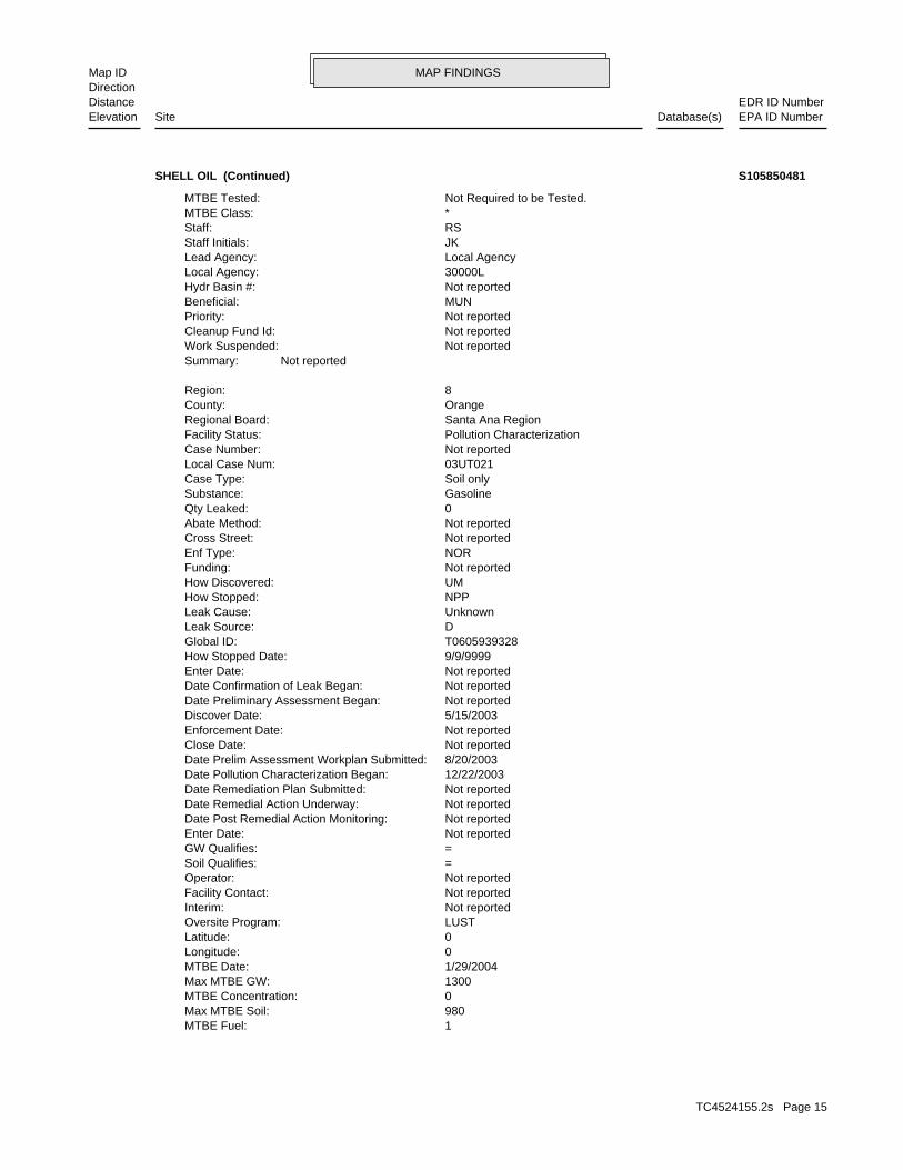
1MTBE Fuel: 980Max MTBE Soil: 0MTBE Concentration: 1300Max MTBE GW: 1/29/2004MTBE Date: 0Longitude: 0Latitude: LUSTOversite Program: Not reportedInterim: Not reportedFacility Contact: Not reportedOperator: =Soil Qualifies: =GW Qualifies: Not reportedEnter Date: Not reportedDate Post Remedial Action Monitoring: Not reportedDate Remedial Action Underway: Not reportedDate Remediation Plan Submitted: 12/22/2003Date Pollution Characterization Began: 8/20/2003Date Prelim Assessment Workplan Submitted: Not reportedClose Date: Not reportedEnforcement Date: 5/15/2003Discover Date: Not reportedDate Preliminary Assessment Began: Not reportedDate Confirmation of Leak Began: Not reportedEnter Date: 9/9/9999How Stopped Date: T0605939328Global ID: DLeak Source: UnknownLeak Cause: NPPHow Stopped: UMHow Discovered: Not reportedFunding: NOREnf Type: Not reportedCross Street: Not reportedAbate Method: 0Qty Leaked: GasolineSubstance: Soil onlyCase Type: 03UT021Local Case Num: Not reportedCase Number: Pollution CharacterizationFacility Status: Santa Ana RegionRegional Board: OrangeCounty: 8Region:
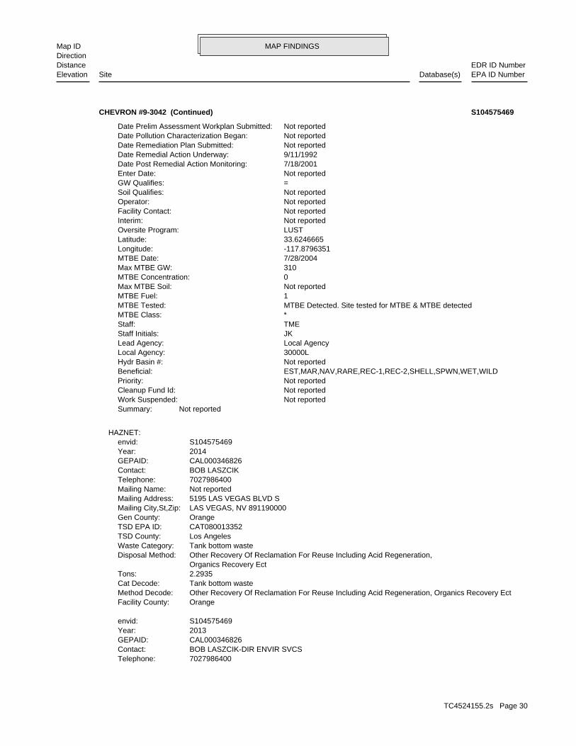
Not reportedSummary: Not reportedWork Suspended: Not reportedCleanup Fund Id: Not reportedPriority: MUNBeneficial: Not reportedHydr Basin #: 30000LLocal Agency: Local AgencyLead Agency: JKStaff Initials: RSStaff: *MTBE Class: Not Required to be Tested.MTBE Tested:
SHELL OIL (Continued) S105850481
TC4524155.2s Page 15
MAP FINDINGSMap IDDirection
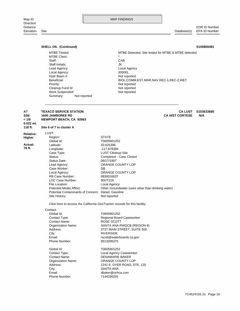
EDR ID NumberDistanceEPA ID NumberDatabase(s)SiteElevation
Not reportedSummary: Not reportedWork Suspended: Not reportedCleanup Fund Id: Not reportedPriority: BIOL,COMM,EST,MAR,NAV,REC-1,REC-2,WETBeneficial: Not reportedHydr Basin #: 30000LLocal Agency: Local AgencyLead Agency: JKStaff Initials: CABStaff: *MTBE Class: MTBE Detected. Site tested for MTBE & MTBE detectedMTBE Tested:
SHELL OIL (Continued) S105850481
7144336255Phone Number: [email protected]: SANTA ANACity: 1241 E. DYER ROAD, STE. 120Address: ORANGE COUNTY LOPOrganization Name: DENAMARIE BAKERContact Name: Local Agency CaseworkerContact Type: T0605901252Global Id:
9513206375Phone Number: [email protected]: RIVERSIDECity: 3737 MAIN STREET, SUITE 500Address: SANTA ANA RWQCB (REGION 8)Organization Name: ROSE SCOTTContact Name: Regional Board CaseworkerContact Type: T0605901252Global Id:
Contact:
Click here to access the California GeoTracker records for this facility:
Not reportedSite History: Diesel, GasolinePotential Contaminants of Concern: Other Groundwater (uses other than drinking water)Potential Media Affect: Local AgencyFile Location: 90UT219LOC Case Number: 083001663TRB Case Number: ORANGE COUNTY LOPLocal Agency: DBCase Worker: ORANGE COUNTY LOPLead Agency: 06/17/1997Status Date: Completed - Case ClosedStatus: LUST Cleanup SiteCase Type: -117.878384Longitude: 33.625396Latitude: T0605901252Global Id: STATERegion:
LUST:
118 ft. Site 6 of 7 in cluster A0.022 mi.
Relative:Higher
Actual:78 ft.
< 1/8 NEWPORT BEACH, CA 92663SSE CA HIST CORTESE1600 JAMBOREE RD N/AA7 CA LUSTTEXACO SERVICE STATION S103633685
TC4524155.2s Page 16

MAP FINDINGSMap IDDirection
EDR ID NumberDistanceEPA ID NumberDatabase(s)SiteElevation
submitted by consultants for the responsible party. accuracy of any professional interpretations provided in reports GeoTracker for site history. Orange County is not responsible for the Please refer to recent Site Documents or Monitoring Reports inSite History: GasolinePotential Contaminants of Concern: water Other Groundwater (uses other than drinking water), Soil, SurfacePotential Media Affect: Local AgencyFile Location: 03UT021LOC Case Number: Not reportedRB Case Number: ORANGE COUNTY LOPLocal Agency: DBCase Worker: ORANGE COUNTY LOPLead Agency: 08/12/2014Status Date: Completed - Case ClosedStatus: LUST Cleanup SiteCase Type: -117.878505955Longitude: 33.625353401Latitude: T0605939328Global Id: STATERegion:
Leak ReportedAction: 09/24/1990Date: OtherAction Type: T0605901252Global Id:
LOP Case Closure Summary to RBAction: 04/02/1997Date: ENFORCEMENTAction Type: T0605901252Global Id:
Leak DiscoveryAction: 09/24/1990Date: OtherAction Type: T0605901252Global Id:
Other (Use Description Field)Action: 06/25/1992Date: REMEDIATIONAction Type: T0605901252Global Id:
ExcavationAction: 06/25/1992Date: REMEDIATIONAction Type: T0605901252Global Id:
Regulatory Activities:
09/24/1990Status Date: Open - Case Begin DateStatus: T0605901252Global Id:
06/17/1997Status Date: Completed - Case ClosedStatus: T0605901252Global Id:
Status History:
TEXACO SERVICE STATION (Continued) S103633685
TC4524155.2s Page 17

MAP FINDINGSMap IDDirection
EDR ID NumberDistanceEPA ID NumberDatabase(s)SiteElevation
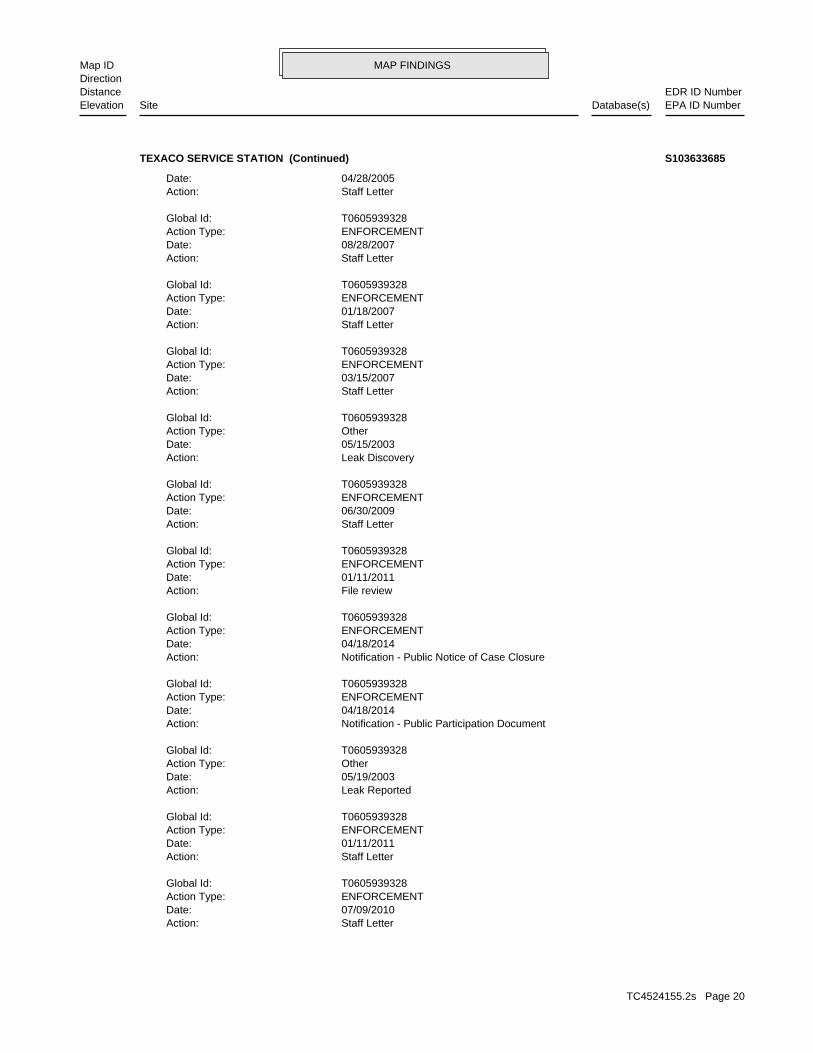
Preliminary Site Assessment WorkplanAction: 08/20/2003Date: RESPONSEAction Type: T0605939328Global Id:
Staff LetterAction: 06/18/2014Date: ENFORCEMENTAction Type: T0605939328Global Id:
Regulatory Activities:
12/22/2003Status Date: Open - Site AssessmentStatus: T0605939328Global Id:
08/20/2003Status Date: Open - Site AssessmentStatus: T0605939328Global Id:
06/18/2012Status Date: Open - RemediationStatus: T0605939328Global Id:
03/12/2014Status Date: Open - Eligible for ClosureStatus: T0605939328Global Id:
05/15/2003Status Date: Open - Case Begin DateStatus: T0605939328Global Id:
08/12/2014Status Date: Completed - Case ClosedStatus: T0605939328Global Id:
Status History:
9517824495Phone Number: [email protected]: RIVERSIDECity: 3737 MAIN STREET, SUITE 500Address: SANTA ANA RWQCB (REGION 8)Organization Name: CARL BERNHARDTContact Name: Regional Board CaseworkerContact Type: T0605939328Global Id:
7144336255Phone Number: [email protected]: SANTA ANACity: 1241 E. DYER ROAD, STE. 120Address: ORANGE COUNTY LOPOrganization Name: DENAMARIE BAKERContact Name: Local Agency CaseworkerContact Type: T0605939328Global Id:
Contact:
Click here to access the California GeoTracker records for this facility:
TEXACO SERVICE STATION (Continued) S103633685
TC4524155.2s Page 18

MAP FINDINGSMap IDDirection
EDR ID NumberDistanceEPA ID NumberDatabase(s)SiteElevation
ENFORCEMENTAction Type: T0605939328Global Id:
Staff LetterAction: 05/18/2004Date: ENFORCEMENTAction Type: T0605939328Global Id:
Notice of ResponsibilityAction: 05/22/2003Date: ENFORCEMENTAction Type: T0605939328Global Id:
Staff LetterAction: 11/25/2008Date: ENFORCEMENTAction Type: T0605939328Global Id:
Staff LetterAction: 01/18/2012Date: ENFORCEMENTAction Type: T0605939328Global Id:
Staff LetterAction: 09/12/2011Date: ENFORCEMENTAction Type: T0605939328Global Id:
Notification - Public Notice of ROD/RAP/CAPAction: 12/21/2011Date: ENFORCEMENTAction Type: T0605939328Global Id:
Staff LetterAction: 11/22/2013Date: ENFORCEMENTAction Type: T0605939328Global Id:
File reviewAction: 08/23/2010Date: ENFORCEMENTAction Type: T0605939328Global Id:
Staff LetterAction: 07/03/2009Date: ENFORCEMENTAction Type: T0605939328Global Id:
ExcavationAction: 12/16/2010Date: REMEDIATIONAction Type: T0605939328Global Id:
ExcavationAction: 06/03/2003Date: REMEDIATIONAction Type: T0605939328Global Id:
TEXACO SERVICE STATION (Continued) S103633685
TC4524155.2s Page 19
MAP FINDINGSMap IDDirection
EDR ID NumberDistanceEPA ID NumberDatabase(s)SiteElevation
Staff LetterAction: 07/09/2010Date: ENFORCEMENTAction Type: T0605939328Global Id:
Staff LetterAction: 01/11/2011Date: ENFORCEMENTAction Type: T0605939328Global Id:
Leak ReportedAction: 05/19/2003Date: OtherAction Type: T0605939328Global Id:
Notification - Public Participation DocumentAction: 04/18/2014Date: ENFORCEMENTAction Type: T0605939328Global Id:
Notification - Public Notice of Case ClosureAction: 04/18/2014Date: ENFORCEMENTAction Type: T0605939328Global Id:
File reviewAction: 01/11/2011Date: ENFORCEMENTAction Type: T0605939328Global Id:
Staff LetterAction: 06/30/2009Date: ENFORCEMENTAction Type: T0605939328Global Id:
Leak DiscoveryAction: 05/15/2003Date: OtherAction Type: T0605939328Global Id:
Staff LetterAction: 03/15/2007Date: ENFORCEMENTAction Type: T0605939328Global Id:
Staff LetterAction: 01/18/2007Date: ENFORCEMENTAction Type: T0605939328Global Id:
Staff LetterAction: 08/28/2007Date: ENFORCEMENTAction Type: T0605939328Global Id:
Staff LetterAction: 04/28/2005Date:
TEXACO SERVICE STATION (Continued) S103633685
TC4524155.2s Page 20

MAP FINDINGSMap IDDirection
EDR ID NumberDistanceEPA ID NumberDatabase(s)SiteElevation
083001663TReg Id: LTNKAReg By: 30Facility County Code: CORTESERegion:
HIST CORTESE:
RO0003200Record ID: Soil OnlyCase Type: 08/12/2014Date Closed: Gasoline-Automotive (motor gasoline and additives), leaded & unleadedReleased Substance: Certification (Case Closed)Current Status: 03UT021Facility Id: ORANGERegion:
RO0002213Record ID: Other Ground WaterCase Type: Not reportedDate Closed: (motor gasoline and additives), leaded & unleaded Diesel fuel oil and additives, Nos.1-D, 2-D, 2-4; Gasoline-AutomotiveReleased Substance: Certification (Case Closed)Current Status: 90UT219Facility Id: ORANGERegion:
ORANGE CO. LUST:
Closure/No Further Action LetterAction: 08/12/2014Date: ENFORCEMENTAction Type: T0605939328Global Id:
Staff LetterAction: 06/18/2012Date: ENFORCEMENTAction Type: T0605939328Global Id:
File reviewAction: 03/30/2011Date: ENFORCEMENTAction Type: T0605939328Global Id:
TEXACO SERVICE STATION (Continued) S103633685
-117.8770591Longitude: 33.6266637Latitude: ORANGE COUNTYPermitting Agency: 2191Facility ID:
UST:
118 ft. Site 7 of 7 in cluster A0.022 mi.
Relative:Higher
Actual:78 ft.
< 1/8 NEWPORT BEACH, CA 92660SSE 1600 JAMBOREE RD N/AA8 CA USTTEXACO U004061471
TC4524155.2s Page 21

MAP FINDINGSMap IDDirection
EDR ID NumberDistanceEPA ID NumberDatabase(s)SiteElevation
Closure/No Further Action LetterAction: 05/15/2001Date: ENFORCEMENTAction Type: T0605900051Global Id:
Regulatory Activities:
03/18/1986Status Date: Open - Case Begin DateStatus: T0605900051Global Id:
05/15/2001Status Date: Completed - Case ClosedStatus: T0605900051Global Id:
Status History:
9513202007Phone Number: [email protected]: RIVERSIDECity: 3737 MAIN STREET, SUITE 500Address: SANTA ANA RWQCB (REGION 8)Organization Name: TOM E. MBEKE-EKANEMContact Name: Regional Board CaseworkerContact Type: T0605900051Global Id:
7144336255Phone Number: [email protected]: SANTA ANACity: 1241 E. DYER ROAD, STE. 120Address: ORANGE COUNTY LOPOrganization Name: DENAMARIE BAKERContact Name: Local Agency CaseworkerContact Type: T0605900051Global Id:
Contact:
Click here to access the California GeoTracker records for this facility:
Not reportedSite History: GasolinePotential Contaminants of Concern: Other Groundwater (uses other than drinking water)Potential Media Affect: Local AgencyFile Location: 86UT021LOC Case Number: 083000064TRB Case Number: ORANGE COUNTY LOPLocal Agency: DBCase Worker: ORANGE COUNTY LOPLead Agency: 05/15/2001Status Date: Completed - Case ClosedStatus: LUST Cleanup SiteCase Type: -117.8767259Longitude: 33.628436Latitude: T0605900051Global Id: STATERegion:
LUST:
268 ft. Site 1 of 3 in cluster B0.051 mi.
Relative:Higher
Actual:72 ft.
< 1/8 CA SWEEPS USTNEWPORT BEACH, CA 92660NE CA UST1850 JAMBOREE RD N/AB9 CA LUSTBIG CANYON COUNTRY CLUB U003783915
TC4524155.2s Page 22
MAP FINDINGSMap IDDirection
EDR ID NumberDistanceEPA ID NumberDatabase(s)SiteElevation
Not reportedEnter Date: 9/9/9999How Stopped Date: T0605900051Global ID: UnknownLeak Source: UnknownLeak Cause: Close TankHow Stopped: Tank ClosureHow Discovered: Not reportedFunding: Not reportedEnf Type: Not reportedCross Street: Not reportedAbate Method: 0Qty Leaked: GasolineSubstance: Other ground water affectedCase Type: 86UT021Local Case Num: 083000064TCase Number: Case ClosedFacility Status: Santa Ana RegionRegional Board: OrangeCounty: 8Region:
LUST REG 8:
RO0001218Record ID: Other Ground WaterCase Type: 05/15/2001Date Closed: Gasoline-Automotive (motor gasoline and additives), leaded & unleadedReleased Substance: Certification (Case Closed)Current Status: 86UT021Facility Id: ORANGERegion:
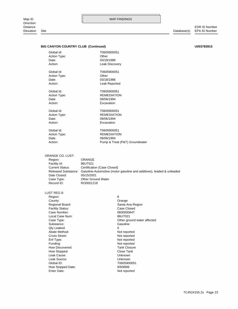
ORANGE CO. LUST:
Pump & Treat (P&T) GroundwaterAction: 09/06/1994Date: REMEDIATIONAction Type: T0605900051Global Id:
ExcavationAction: 09/06/1994Date: REMEDIATIONAction Type: T0605900051Global Id:
ExcavationAction: 09/06/1994Date: REMEDIATIONAction Type: T0605900051Global Id:
Leak ReportedAction: 03/18/1986Date: OtherAction Type: T0605900051Global Id:
Leak DiscoveryAction: 03/18/1986Date: OtherAction Type: T0605900051Global Id:
BIG CANYON COUNTRY CLUB (Continued) U003783915
TC4524155.2s Page 23

MAP FINDINGSMap IDDirection
EDR ID NumberDistanceEPA ID NumberDatabase(s)SiteElevation
Not reportedActive Date: 500Capacity: ATank Status: 30-000-006910-000001SWRCB Tank Id: Not reportedOwner Tank Id: 02-29-88Created Date: 09-15-92Action Date: 09-30-92Referral Date: 44-016545Board Of Equalization: 9Number: 6910Comp Number: ActiveStatus:
SWEEPS UST:
-117.87741Longitude: 33.62734Latitude: ORANGE COUNTYPermitting Agency: 6910Facility ID:
UST:
Not reportedSummary: Not reportedWork Suspended: Not reportedCleanup Fund Id: Not reportedPriority: MUNBeneficial: Not reportedHydr Basin #: 30000LLocal Agency: Local AgencyLead Agency: JKStaff Initials: TMEStaff: *MTBE Class: Site NOT Tested for MTBE.Includes Unknown and Not Analyzed.MTBE Tested: 1MTBE Fuel: Not reportedMax MTBE Soil: 0MTBE Concentration: Not reportedMax MTBE GW: Not reportedMTBE Date: -117.87672Longitude: 33.6284754Latitude: LUSTOversite Program: Not reportedInterim: Not reportedFacility Contact: Not reportedOperator: Not reportedSoil Qualifies: Not reportedGW Qualifies: Not reportedEnter Date: Not reportedDate Post Remedial Action Monitoring: Not reportedDate Remedial Action Underway: Not reportedDate Remediation Plan Submitted: Not reportedDate Pollution Characterization Began: Not reportedDate Prelim Assessment Workplan Submitted: 5/15/2001Close Date: Not reportedEnforcement Date: 3/18/1986Discover Date: Not reportedDate Preliminary Assessment Began: Not reportedDate Confirmation of Leak Began:
BIG CANYON COUNTRY CLUB (Continued) U003783915
TC4524155.2s Page 24

MAP FINDINGSMap IDDirection
EDR ID NumberDistanceEPA ID NumberDatabase(s)SiteElevation
Not reportedNumber Of Tanks: REG UNLEADEDContent: PSTG: M.V. FUELTank Use: Not reportedActive Date: 1000Capacity: ATank Status: 30-000-006910-000003SWRCB Tank Id: Not reportedOwner Tank Id: 02-29-88Created Date: 09-15-92Action Date: 09-30-92Referral Date: 44-016545Board Of Equalization: 9Number: 6910Comp Number: ActiveStatus:
Not reportedNumber Of Tanks: REG UNLEADEDContent: PSTG: M.V. FUELTank Use: Not reportedActive Date: 1000Capacity: ATank Status: 30-000-006910-000002SWRCB Tank Id: Not reportedOwner Tank Id: 02-29-88Created Date: 09-15-92Action Date: 09-30-92Referral Date: 44-016545Board Of Equalization: 9Number: 6910Comp Number: ActiveStatus:
3Number Of Tanks: DIESELContent: PSTG: M.V. FUELTank Use:
BIG CANYON COUNTRY CLUB (Continued) U003783915
Not reportedContact Phone: Not reportedContact: NEWPORT BEACH 92660Mailing City,St,Zip: Not reportedMailing Address 2: 1 BIG CANYON DRMailing Address: Not reportedMail To: 7146445404Facility Phone: Not reportedSIC Code: Not reportedCortese Code: Not reportedRegulated ID: UTNKARegulated By: 30000419Facility ID:
CA FID UST:
268 ft. Site 2 of 3 in cluster B0.051 mi.
Relative:Higher
Actual:72 ft.
< 1/8 NEWPORT BEACH, CA 92660NE CA HIST CORTESE1850 N/AB10 CA FID USTBIG CANYON COUNTRY CLUB 1000106106
TC4524155.2s Page 25

MAP FINDINGSMap IDDirection
EDR ID NumberDistanceEPA ID NumberDatabase(s)SiteElevation
083000064TReg Id: LTNKAReg By: 30Facility County Code: CORTESERegion:
HIST CORTESE:
ActiveStatus: Not reportedComments: Not reportedEPA ID: Not reportedNPDES Number: Not reportedDUNs Number:
BIG CANYON COUNTRY CLUB (Continued) 1000106106
1,320Total Gallons: BIG CANYON COUNTRY CLUBOwner: OrangeCertified Unified Program Agencies:
AST:
268 ft. Site 3 of 3 in cluster B0.051 mi.
Relative:Higher
Actual:72 ft.
< 1/8 NEWPORT BEACH, CA 92660NE 1850 JAMBOREE RD N/AB11 CA AST A100336800
4810 PARK NEWPORTAddress: 2007Year: AUTO REJUVENATIONName:
EDR Historical Auto Stations:
777 ft.0.147 mi.
Relative:Higher
Actual:108 ft.
1/8-1/4 NEWPORT BEACH, CA 92660WNW 4810 PARK NEWPORT N/A12 EDR Hist Auto 1015514651
PARK NEWPORT CLEANERS & LAUNDRYName:
2 PARK NEWPORTAddress: 2004Year: PARK NEWPORT CLEANERSName:
2 PARK NEWPORTAddress: 2003Year: PARK NEWPORT CLEANERS & LNDRYName:
2 PARK NEWPORTAddress: 1999Year: PARK NEWPORT CLEANERS & LAUNDRYName:
EDR Historical Cleaners:
797 ft.0.151 mi.
Relative:Higher
Actual:111 ft.
1/8-1/4 NEWPORT BEACH, CA 92660WSW 2 PARK NEWPORT N/A13 EDR Hist Cleaner 1015011961
TC4524155.2s Page 26

MAP FINDINGSMap IDDirection
EDR ID NumberDistanceEPA ID NumberDatabase(s)SiteElevation
2 PARK NEWPORTAddress: 2012Year: PARK NEWPORT CLEANERSName:
2 PARK NEWPORTAddress: 2011Year: PARK NEWPORT CLEANERSName:
2 PARK NEWPORTAddress: 2010Year: PARK NEWPORT CLEANERS & LNDRYName:
2 PARK NEWPORTAddress: 2009Year: PARK NEWPORT CLEANERS & LAUNDRY INCName:
2 PARK NEWPORTAddress: 2008Year: PARK NEWPORT CLEANERS & LAUNDRYName:
2 PARK NEWPORTAddress: 2007Year: PARK NEWPORT CLEANERS & LAUNDRYName:
2 PARK NEWPORTAddress: 2006Year: PARK NEWPORT CLEANERS & LAUNDRYName:
2 PARK NEWPORTAddress: 2005Year:
(Continued) 1015011961
Contact:
Click here to access the California GeoTracker records for this facility:
Not reportedSite History: GasolinePotential Contaminants of Concern: Other Groundwater (uses other than drinking water)Potential Media Affect: Local Agency WarehouseFile Location: 85UT032LOC Case Number: 083000097TRB Case Number: ORANGE COUNTY LOPLocal Agency: DBCase Worker: ORANGE COUNTY LOPLead Agency: 04/05/2005Status Date: Completed - Case ClosedStatus: LUST Cleanup SiteCase Type: -117.8796351Longitude: 33.6246665Latitude: T0605900074Global Id: STATERegion:
LUST:
823 ft. Site 1 of 6 in cluster C0.156 mi.
Relative:Higher
Actual:124 ft.
1/8-1/4 NEWPORT BEACH, CA 92660SSW CA HAZNET1550 JAMBOREE N/AC14 CA LUSTCHEVRON #9-3042 S104575469
TC4524155.2s Page 27

MAP FINDINGSMap IDDirection
EDR ID NumberDistanceEPA ID NumberDatabase(s)SiteElevation
Leak ReportedAction: 03/08/1985Date: OtherAction Type: T0605900074Global Id:
Leak DiscoveryAction: 03/08/1985Date: OtherAction Type: T0605900074Global Id:
Notice of ResponsibilityAction: 03/08/1985Date: ENFORCEMENTAction Type: T0605900074Global Id:
Closure/No Further Action LetterAction: 04/05/2005Date: ENFORCEMENTAction Type: T0605900074Global Id:
Regulatory Activities:
07/18/2001Status Date: Open - Verification MonitoringStatus: T0605900074Global Id:
09/11/1992Status Date: Open - RemediationStatus: T0605900074Global Id:
03/08/1985Status Date: Open - Case Begin DateStatus: T0605900074Global Id:
04/05/2005Status Date: Completed - Case ClosedStatus: T0605900074Global Id:
Status History:
7144336255Phone Number: [email protected]: SANTA ANACity: 1241 E. DYER ROAD, STE. 120Address: ORANGE COUNTY LOPOrganization Name: DENAMARIE BAKERContact Name: Local Agency CaseworkerContact Type: T0605900074Global Id:
9513202007Phone Number: [email protected]: RIVERSIDECity: 3737 MAIN STREET, SUITE 500Address: SANTA ANA RWQCB (REGION 8)Organization Name: TOM E. MBEKE-EKANEMContact Name: Regional Board CaseworkerContact Type: T0605900074Global Id:
CHEVRON #9-3042 (Continued) S104575469
TC4524155.2s Page 28

MAP FINDINGSMap IDDirection
EDR ID NumberDistanceEPA ID NumberDatabase(s)SiteElevation
Not reportedClose Date: Not reportedEnforcement Date: 3/8/1985Discover Date: Not reportedDate Preliminary Assessment Began: Not reportedDate Confirmation of Leak Began: Not reportedEnter Date: 9/9/9999How Stopped Date: T0605900074Global ID: TankLeak Source: UnknownLeak Cause: New TankHow Stopped: Tank TestHow Discovered: Not reportedFunding: NOREnf Type: Not reportedCross Street: Not reportedAbate Method: 0Qty Leaked: GasolineSubstance: Other ground water affectedCase Type: 85UT032Local Case Num: 083000097TCase Number: Post remedial action monitoringFacility Status: Santa Ana RegionRegional Board: OrangeCounty: 8Region:
LUST REG 8:
RO0001505Record ID: Other Ground WaterCase Type: 04/05/2005Date Closed: Gasoline-Automotive (motor gasoline and additives), leaded & unleadedReleased Substance: Certification (Case Closed)Current Status: 85UT032Facility Id: ORANGERegion:
ORANGE CO. LUST:
Soil and Water Investigation ReportAction: 06/08/1985Date: RESPONSEAction Type: T0605900074Global Id:
Free Product RemovalAction: 07/01/1993Date: REMEDIATIONAction Type: T0605900074Global Id:
Other (Use Description Field)Action: 11/01/1995Date: REMEDIATIONAction Type: T0605900074Global Id:
Pump & Treat (P&T) GroundwaterAction: 07/01/1988Date: REMEDIATIONAction Type: T0605900074Global Id:
CHEVRON #9-3042 (Continued) S104575469
TC4524155.2s Page 29
MAP FINDINGSMap IDDirection
EDR ID NumberDistanceEPA ID NumberDatabase(s)SiteElevation
7027986400Telephone: BOB LASZCIK-DIR ENVIR SVCSContact: CAL000346826GEPAID: 2013Year: S104575469envid:
OrangeFacility County: Other Recovery Of Reclamation For Reuse Including Acid Regeneration, Organics Recovery EctMethod Decode: Tank bottom wasteCat Decode: 2.2935Tons: Organics Recovery Ect Other Recovery Of Reclamation For Reuse Including Acid Regeneration,Disposal Method: Tank bottom wasteWaste Category: Los AngelesTSD County: CAT080013352TSD EPA ID: OrangeGen County: LAS VEGAS, NV 891190000Mailing City,St,Zip: 5195 LAS VEGAS BLVD SMailing Address: Not reportedMailing Name: 7027986400Telephone: BOB LASZCIKContact: CAL000346826GEPAID: 2014Year: S104575469envid:
HAZNET:
Not reportedSummary: Not reportedWork Suspended: Not reportedCleanup Fund Id: Not reportedPriority: EST,MAR,NAV,RARE,REC-1,REC-2,SHELL,SPWN,WET,WILDBeneficial: Not reportedHydr Basin #: 30000LLocal Agency: Local AgencyLead Agency: JKStaff Initials: TMEStaff: *MTBE Class: MTBE Detected. Site tested for MTBE & MTBE detectedMTBE Tested: 1MTBE Fuel: Not reportedMax MTBE Soil: 0MTBE Concentration: 310Max MTBE GW: 7/28/2004MTBE Date: -117.8796351Longitude: 33.6246665Latitude: LUSTOversite Program: Not reportedInterim: Not reportedFacility Contact: Not reportedOperator: Not reportedSoil Qualifies: =GW Qualifies: Not reportedEnter Date: 7/18/2001Date Post Remedial Action Monitoring: 9/11/1992Date Remedial Action Underway: Not reportedDate Remediation Plan Submitted: Not reportedDate Pollution Characterization Began: Not reportedDate Prelim Assessment Workplan Submitted:
CHEVRON #9-3042 (Continued) S104575469
TC4524155.2s Page 30

MAP FINDINGSMap IDDirection
EDR ID NumberDistanceEPA ID NumberDatabase(s)SiteElevation
OrangeFacility County: Other Recovery Of Reclamation For Reuse Including Acid Regeneration, Organics Recovery EctMethod Decode: Tank bottom wasteCat Decode: 2.2935Tons: Organics Recovery Ect Other Recovery Of Reclamation For Reuse Including Acid Regeneration,Disposal Method: Tank bottom wasteWaste Category: Not reportedTSD County: CAT080013352TSD EPA ID: Not reportedGen County: LAS VEGAS, NV 891193209Mailing City,St,Zip: 5195 LAS VEGAS BLVD SMailing Address: Not reportedMailing Name: 7028897692Telephone: BOB LASZCIKContact: CAL000346826GEPAID: 2009Year: S104575469envid:
Not reportedFacility County: Other Recovery Of Reclamation For Reuse Including Acid Regeneration, Organics Recovery EctMethod Decode: Not reportedCat Decode: 0.4587Tons: Organics Recovery Ect Other Recovery Of Reclamation For Reuse Including Acid Regeneration,Disposal Method: Not reportedWaste Category: Los AngelesTSD County: CAT080013352TSD EPA ID: OrangeGen County: NEWPORT BEACH, CA 926605912Mailing City,St,Zip: 1550 JAMBOREE RDMailing Address: Not reportedMailing Name:
CHEVRON #9-3042 (Continued) S104575469
Not reportedOwner Tank Id: 02-29-88Created Date: 09-15-92Action Date: 09-30-92Referral Date: 44-015929Board Of Equalization: 9Number: 2196Comp Number: ActiveStatus:
SWEEPS UST:
FA0049936Facility ID:ORANGE CO. UST:
-117.877782Longitude: 33.625913Latitude: ORANGE COUNTYPermitting Agency: 2196Facility ID:
UST:
823 ft. Site 2 of 6 in cluster C0.156 mi.
Relative:Higher
Actual:124 ft.
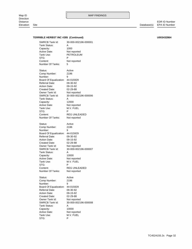
1/8-1/4 NEWPORT BEACH, CA 92660SSW CA SWEEPS UST1550 JAMBOREE RD N/AC15 CA USTTERRIBLE HERBST INC #285 U003432864
TC4524155.2s Page 31
MAP FINDINGSMap IDDirection
EDR ID NumberDistanceEPA ID NumberDatabase(s)SiteElevation
PSTG: M.V. FUELTank Use: Not reportedActive Date: 10000Capacity: ATank Status: 30-000-002196-000008SWRCB Tank Id: Not reportedOwner Tank Id: 02-29-88Created Date: 09-15-92Action Date: 09-30-92Referral Date: 44-015929Board Of Equalization: 9Number: 2196Comp Number: ActiveStatus:
Not reportedNumber Of Tanks: REG UNLEADEDContent: PSTG: M.V. FUELTank Use: Not reportedActive Date: 10000Capacity: ATank Status: 30-000-002196-000007SWRCB Tank Id: Not reportedOwner Tank Id: 02-29-88Created Date: 09-15-92Action Date: 09-30-92Referral Date: 44-015929Board Of Equalization: 9Number: 2196Comp Number: ActiveStatus:
Not reportedNumber Of Tanks: REG UNLEADEDContent: PSTG: M.V. FUELTank Use: Not reportedActive Date: 12000Capacity: ATank Status: 30-000-002196-000006SWRCB Tank Id: Not reportedOwner Tank Id: 02-29-88Created Date: 09-15-92Action Date: 09-30-92Referral Date: 44-015929Board Of Equalization: 9Number: 2196Comp Number: ActiveStatus:
5Number Of Tanks: Not reportedContent: PSTG: PETROLEUMTank Use: Not reportedActive Date: 1000Capacity: ATank Status: 30-000-002196-000001SWRCB Tank Id:
TERRIBLE HERBST INC #285 (Continued) U003432864
TC4524155.2s Page 32

MAP FINDINGSMap IDDirection
EDR ID NumberDistanceEPA ID NumberDatabase(s)SiteElevation
Not reportedNumber Of Tanks: DIESELContent: PSTG: M.V. FUELTank Use: Not reportedActive Date: Not reportedCapacity: ATank Status: 30-000-002196-000009SWRCB Tank Id: Not reportedOwner Tank Id: 02-29-88Created Date: 09-15-92Action Date: 09-30-92Referral Date: 44-015929Board Of Equalization: 9Number: 2196Comp Number: ActiveStatus:
Not reportedNumber Of Tanks: DIESELContent:
TERRIBLE HERBST INC #285 (Continued) U003432864
3Container Num: 003Tank Num:
Stock InventorLeak Detection: 0000250Container Construction Thickness: Not reportedType of Fuel: PRODUCTTank Used for: 00010000Tank Capacity: 1971Year Installed: 2Container Num: 002Tank Num:
Stock InventorLeak Detection: 0000250Container Construction Thickness: Not reportedType of Fuel: PRODUCTTank Used for: 00005000Tank Capacity: 1971Year Installed: 1Container Num: 001Tank Num:
0004Total Tanks: SAN FRANCISCO, CA 94105Owner City,St,Zip: 575 MARKETOwner Address: CHEVRON U.S.A. INC.Owner Name: 7146447933Telephone: SCHMIDT,ROGER JContact Name: Not reportedOther Type: Gas StationFacility Type: 00000062368Facility ID: STATERegion:
HIST UST:
823 ft. Site 3 of 6 in cluster C0.156 mi.
Relative:Higher
Actual:124 ft.
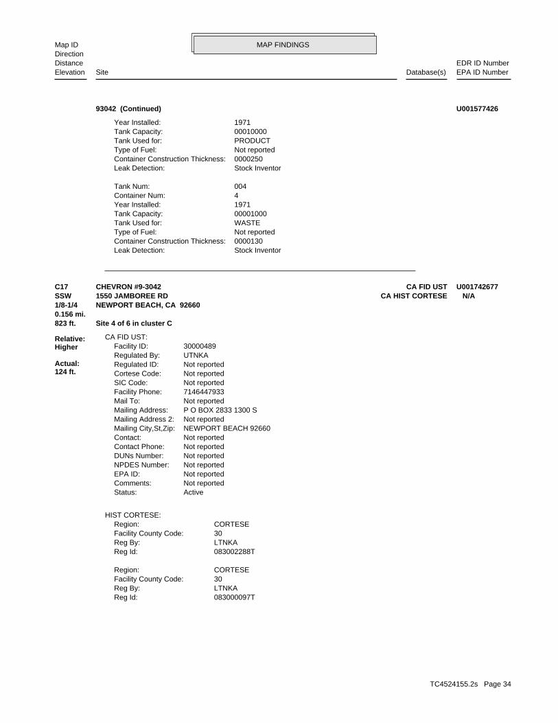
1/8-1/4 NEWPORT BEACH, CA 92660SSW 1550 JAMBOREE RD N/AC16 CA HIST UST93042 U001577426
TC4524155.2s Page 33
MAP FINDINGSMap IDDirection
EDR ID NumberDistanceEPA ID NumberDatabase(s)SiteElevation
Stock InventorLeak Detection: 0000130Container Construction Thickness: Not reportedType of Fuel: WASTETank Used for: 00001000Tank Capacity: 1971Year Installed: 4Container Num: 004Tank Num:
Stock InventorLeak Detection: 0000250Container Construction Thickness: Not reportedType of Fuel: PRODUCTTank Used for: 00010000Tank Capacity: 1971Year Installed:
93042 (Continued) U001577426
083000097TReg Id: LTNKAReg By: 30Facility County Code: CORTESERegion:
083002288TReg Id: LTNKAReg By: 30Facility County Code: CORTESERegion:
HIST CORTESE:
ActiveStatus: Not reportedComments: Not reportedEPA ID: Not reportedNPDES Number: Not reportedDUNs Number: Not reportedContact Phone: Not reportedContact: NEWPORT BEACH 92660Mailing City,St,Zip: Not reportedMailing Address 2: P O BOX 2833 1300 SMailing Address: Not reportedMail To: 7146447933Facility Phone: Not reportedSIC Code: Not reportedCortese Code: Not reportedRegulated ID: UTNKARegulated By: 30000489Facility ID:
CA FID UST:
823 ft. Site 4 of 6 in cluster C0.156 mi.
Relative:Higher
Actual:124 ft.
1/8-1/4 NEWPORT BEACH, CA 92660SSW CA HIST CORTESE1550 JAMBOREE RD N/AC17 CA FID USTCHEVRON #9-3042 U001742677
TC4524155.2s Page 34
MAP FINDINGSMap IDDirection
EDR ID NumberDistanceEPA ID NumberDatabase(s)SiteElevation
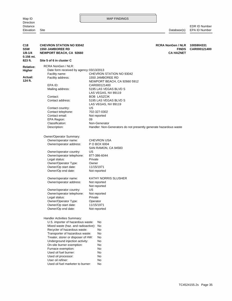
NoUsed oil fuel marketer to burner: NoUser oil refiner: NoUsed oil processor: NoUsed oil fuel burner: NoFurnace exemption: NoOn-site burner exemption: NoUnderground injection activity: NoTreater, storer or disposer of HW: NoTransporter of hazardous waste: NoRecycler of hazardous waste: NoMixed waste (haz. and radioactive): NoU.S. importer of hazardous waste:
Handler Activities Summary:
Not reportedOwner/Op end date: 11/15/1971Owner/Op start date: OperatorOwner/Operator Type: PrivateLegal status: Not reportedOwner/operator telephone: USOwner/operator country: Not reported Not reportedOwner/operator address: KATHY NORRIS SLUSHEROwner/operator name:
Not reportedOwner/Op end date: 11/15/1971Owner/Op start date: OwnerOwner/Operator Type: PrivateLegal status: 877-386-6044Owner/operator telephone: USOwner/operator country: SAN RAMON, CA 94583 P O BOX 6004Owner/operator address: CHEVRON USAOwner/operator name:
Owner/Operator Summary:
Handler: Non-Generators do not presently generate hazardous wasteDescription: Non-GeneratorClassification: 09EPA Region: Not reportedContact email: 702-327-0302Contact telephone: USContact country: LAS VEGAS, NV 89119 5195 LAS VEGAS BLVD SContact address: BOB LASZCIKContact: LAS VEGAS, NV 89119 5195 LAS VEGAS BLVD SMailing address: CAR000121400EPA ID: NEWPORT BEACH, CA 92660 5912 1550 JAMBOREE RDFacility address: CHEVRON STATION NO 93042Facility name: 03/13/2013Date form received by agency:
RCRA NonGen / NLR:
823 ft. Site 5 of 6 in cluster C0.156 mi.
Relative:Higher
Actual:124 ft.
1/8-1/4 CA HAZNETNEWPORT BEACH, CA 92660SSW FINDS1550 JAMBOREE RD CAR000121400C18 RCRA NonGen / NLRCHEVRON STATION NO 93042 1005904331
TC4524155.2s Page 35

MAP FINDINGSMap IDDirection
EDR ID NumberDistanceEPA ID NumberDatabase(s)SiteElevation
2005Year: 1005904331envid:
OrangeFacility County: Other Recovery Of Reclamation For Reuse Including Acid Regeneration, Organics Recovery EctMethod Decode: Aqueous solution with total organic residues less than 10 percentCat Decode: 0.02Tons: Organics Recovery Ect Other Recovery Of Reclamation For Reuse Including Acid Regeneration,Disposal Method: Aqueous solution with total organic residues less than 10 percentWaste Category: Not reportedTSD County: CAD008302903TSD EPA ID: Not reportedGen County: San Ramon, CA 94583Mailing City,St,Zip: PO BOX 6004Mailing Address: Not reportedMailing Name: 9258425931Telephone: Kathy NorrisContact: CAR000121400GEPAID: 2006Year: 1005904331envid:
HAZNET:
corrective action activities required under RCRA.program staff to track the notification, permit, compliance, andand treat, store, or dispose of hazardous waste. RCRAInfo allows RCRAevents and activities related to facilities that generate, transport,Conservation and Recovery Act (RCRA) program through the tracking ofRCRAInfo is a national information system that supports the Resource
facilities.generators, transporters, and treatment, storage, and disposalprovides California with information on hazardous waste shipments forCalifornia Hazardous Waste Tracking System - Datamart (HWTS-DATAMART) Environmental Interest/Information System
110012543480Registry ID:
FINDS:
No violations foundViolation Status:
BENZENE. Waste name: D018. Waste code:
IGNITABLE WASTE. Waste name: D001. Waste code:
Small Quantity GeneratorClassification: CHEVRON STATION NO 93042Site name: 05/16/2002Date form received by agency:
Historical Generators:
NoUsed oil transporter: NoUsed oil transfer facility: NoUsed oil Specification marketer:
CHEVRON STATION NO 93042 (Continued) 1005904331
TC4524155.2s Page 36

MAP FINDINGSMap IDDirection
EDR ID NumberDistanceEPA ID NumberDatabase(s)SiteElevation
OrangeFacility County: Not reportedMethod Decode: Aqueous solution with total organic residues less than 10 percentCat Decode: 0.41Tons: Not reportedDisposal Method: Aqueous solution with total organic residues less than 10 percentWaste Category: Not reportedTSD County: CAD008302903TSD EPA ID: Not reportedGen County: San Ramon, CA 94583Mailing City,St,Zip: PO BOX 6004Mailing Address: Not reportedMailing Name: 9258425931Telephone: Kathy NorrisContact: CAR000121400GEPAID: 2003Year: 1005904331envid:
OrangeFacility County: RecyclerMethod Decode: Aqueous solution with total organic residues less than 10 percentCat Decode: 0.22Tons: RecyclerDisposal Method: Aqueous solution with total organic residues less than 10 percentWaste Category: Not reportedTSD County: CAD008302903TSD EPA ID: Not reportedGen County: San Ramon, CA 94583Mailing City,St,Zip: PO BOX 6004Mailing Address: Not reportedMailing Name: 9258425931Telephone: Kathy NorrisContact: CAR000121400GEPAID:
CHEVRON STATION NO 93042 (Continued) 1005904331
CHEVRON STATIONSName:
1550 JAMBOREE RDAddress: 2007Year: NEWPORT CENTER CHEVRON INCName:
1550 JAMBOREE RDAddress: 2005Year: NEWPORT CENTER CHEVRON INCName:
1550 JAMBOREE RDAddress: 2003Year: CHEVRON STATIONS INCName:
1550 JAMBOREE RDAddress: 1999Year: NEWPORT CENTER CHEVRON INCORPORATEDName:
EDR Historical Auto Stations:
823 ft. Site 6 of 6 in cluster C0.156 mi.
Relative:Higher
Actual:124 ft.
1/8-1/4 NEWPORT BEACH, CA 92660SSW 1550 JAMBOREE RD N/AC19 EDR Hist Auto 1015246656
TC4524155.2s Page 37

MAP FINDINGSMap IDDirection
EDR ID NumberDistanceEPA ID NumberDatabase(s)SiteElevation
1550 JAMBOREE RDAddress: 2009Year: CHEVRON STATIONSName:
1550 JAMBOREE RDAddress: 2008Year:
(Continued) 1015246656
05/01/1997Status Date: Completed - Case ClosedStatus: T0605900841Global Id:
Status History:
9517824495Phone Number: [email protected]: RIVERSIDECity: 3737 MAIN STREET, SUITE 500Address: SANTA ANA RWQCB (REGION 8)Organization Name: CARL BERNHARDTContact Name: Regional Board CaseworkerContact Type: T0605900841Global Id:
Not reportedPhone Number: Not reportedEmail: SANTA ANACity: 2009 E. EDINGER AVE.Address: ORANGE COUNTYOrganization Name: LUIS LODRIGUEZAContact Name: Local Agency CaseworkerContact Type: T0605900841Global Id:
Contact:
Click here to access the California GeoTracker records for this facility:
groundwater oversite. the soil portion 5/1/1997. Case transfered to RB in 1997 for OCHCA oversaw investigation and remediation of the soil and closedSite History: DieselPotential Contaminants of Concern: SoilPotential Media Affect: Not reportedFile Location: 95IC008LOC Case Number: 083001066TRB Case Number: ORANGE COUNTYLocal Agency: LLCase Worker: ORANGE COUNTYLead Agency: 05/01/1997Status Date: Completed - Case ClosedStatus: LUST Cleanup SiteCase Type: -117.8697966Longitude: 33.6296067Latitude: T0605900841Global Id: STATERegion:
LUST:
1018 ft.0.193 mi.
Relative:Higher
Actual:139 ft.
1/8-1/4 CA HIST CORTESENEWPORT BEACH, CA 92660NE CA Orange Co. Industrial Site3000 FORD RD N/A20 CA LUSTFORD AERONUTRONIC S101299867
TC4524155.2s Page 38
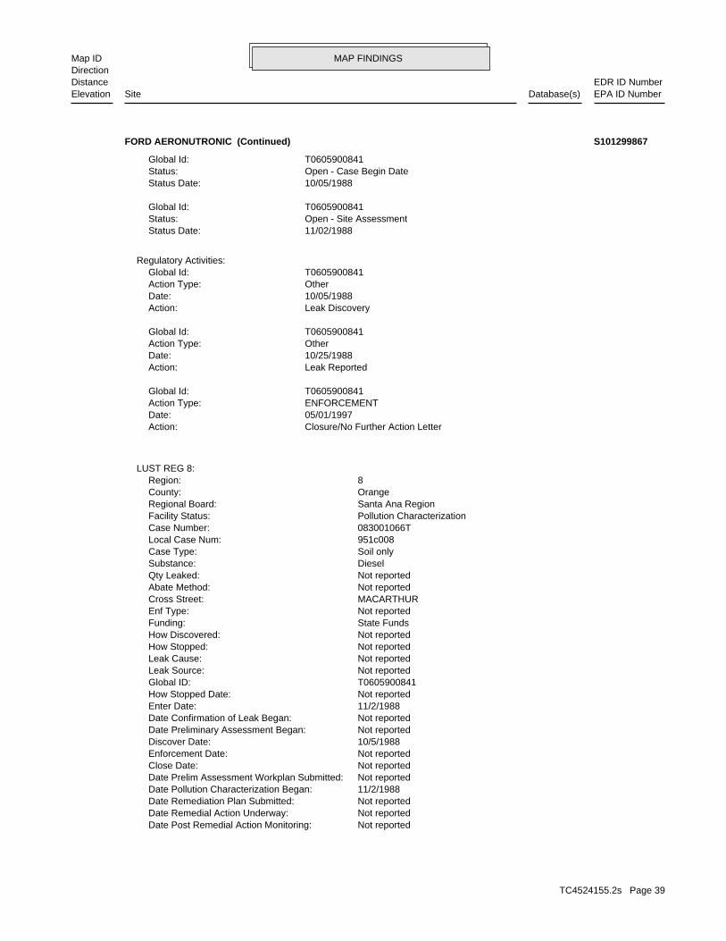
MAP FINDINGSMap IDDirection
EDR ID NumberDistanceEPA ID NumberDatabase(s)SiteElevation
Not reportedDate Post Remedial Action Monitoring: Not reportedDate Remedial Action Underway: Not reportedDate Remediation Plan Submitted: 11/2/1988Date Pollution Characterization Began: Not reportedDate Prelim Assessment Workplan Submitted: Not reportedClose Date: Not reportedEnforcement Date: 10/5/1988Discover Date: Not reportedDate Preliminary Assessment Began: Not reportedDate Confirmation of Leak Began: 11/2/1988Enter Date: Not reportedHow Stopped Date: T0605900841Global ID: Not reportedLeak Source: Not reportedLeak Cause: Not reportedHow Stopped: Not reportedHow Discovered: State FundsFunding: Not reportedEnf Type: MACARTHURCross Street: Not reportedAbate Method: Not reportedQty Leaked: DieselSubstance: Soil onlyCase Type: 951c008Local Case Num: 083001066TCase Number: Pollution CharacterizationFacility Status: Santa Ana RegionRegional Board: OrangeCounty: 8Region:
LUST REG 8:
Closure/No Further Action LetterAction: 05/01/1997Date: ENFORCEMENTAction Type: T0605900841Global Id:
Leak ReportedAction: 10/25/1988Date: OtherAction Type: T0605900841Global Id:
Leak DiscoveryAction: 10/05/1988Date: OtherAction Type: T0605900841Global Id:
Regulatory Activities:
11/02/1988Status Date: Open - Site AssessmentStatus: T0605900841Global Id:
10/05/1988Status Date: Open - Case Begin DateStatus: T0605900841Global Id:
FORD AERONUTRONIC (Continued) S101299867
TC4524155.2s Page 39

MAP FINDINGSMap IDDirection
EDR ID NumberDistanceEPA ID NumberDatabase(s)SiteElevation
083001795TReg Id: LTNKAReg By: 30Facility County Code: CORTESERegion:
083002510TReg Id: LTNKAReg By: 30Facility County Code: CORTESERegion:
083001377TReg Id: LTNKAReg By: 30Facility County Code: CORTESERegion:
083001106TReg Id: LTNKAReg By: 30Facility County Code: CORTESERegion:
HIST CORTESE:
ORGANIC COMPOUNDSReleased Chemical: After soil closure, referred to Regional Board for GW oversightClosure Type: CLOSED 5/1/1997Current Status: RO0000527Record ID: ORANGERegion: 95IC008Case ID:
Orange Co. Industrial Site:
Not reportedSummary: Not reportedWork Suspended: Not reportedCleanup Fund Id: Not reportedPriority: Not reportedBeneficial: COASTAL PLAIN OF ORAHydr Basin #: 30000Local Agency: Local AgencyLead Agency: Not reportedStaff Initials: CABStaff: *MTBE Class: Not Required to be Tested.MTBE Tested: 0MTBE Fuel: Not reportedMax MTBE Soil: 0MTBE Concentration: Not reportedMax MTBE GW: Not reportedMTBE Date: -117.8647337Longitude: 33.6397491Latitude: LUSTOversite Program: Not reportedInterim: Not reportedFacility Contact: Not reportedOperator: Not reportedSoil Qualifies: Not reportedGW Qualifies: 11/2/1988Enter Date:
FORD AERONUTRONIC (Continued) S101299867
TC4524155.2s Page 40

MAP FINDINGSMap IDDirection
EDR ID NumberDistanceEPA ID NumberDatabase(s)SiteElevation
NoFurnace exemption: NoOn-site burner exemption: NoUnderground injection activity: NoTreater, storer or disposer of HW: NoTransporter of hazardous waste: NoRecycler of hazardous waste: NoMixed waste (haz. and radioactive): NoU.S. importer of hazardous waste:
Handler Activities Summary:
Not reportedOwner/Op end date: Not reportedOwner/Op start date: OperatorOwner/Operator Type: PrivateLegal status: (415) 555-1212Owner/operator telephone: Not reportedOwner/operator country: NOT REQUIRED, ME 99999 NOT REQUIREDOwner/operator address: NOT REQUIREDOwner/operator name:
Not reportedOwner/Op end date: Not reportedOwner/Op start date: OwnerOwner/Operator Type: PrivateLegal status: (415) 555-1212Owner/operator telephone: Not reportedOwner/operator country: NOT REQUIRED, ME 99999 NOT REQUIREDOwner/operator address: DOUGLAS WILLIAMSOwner/operator name:
Owner/Operator Summary:
hazardous waste at any time waste during any calendar month, and accumulates more than 1000 kg of hazardous waste at any time; or generates 100 kg or less of hazardous waste during any calendar month and accumulates less than 6000 kg of Handler: generates more than 100 and less than 1000 kg of hazardousDescription: Small Small Quantity GeneratorClassification: 09EPA Region: Not reportedContact email: (714) 541-4327Contact telephone: USContact country: NEWPORT BEACH, CA 92677 400 PARK NEWPORT #203Contact address: ENVIRONMENTAL MANAGERContact: S LAGUNA, CA 92677 PO BOX 693Mailing address: CAD981998511EPA ID: NEWPORT BEACH, CA 92657 400 PARK NEWPORT #203Facility address: NORTHCOTT WILLIAMS INCFacility name: 06/09/1987Date form received by agency:
RCRA-SQG:
1032 ft.0.195 mi.
Relative:Higher
Actual:109 ft.
1/8-1/4 NEWPORT BEACH, CA 92657West FINDS400 PARK NEWPORT #203 CAD98199851121 RCRA-SQGNORTHCOTT WILLIAMS INC 1000407256
TC4524155.2s Page 41
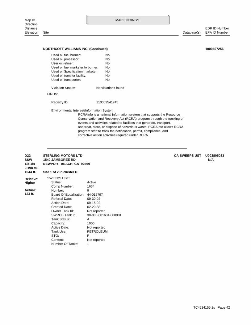
MAP FINDINGSMap IDDirection
EDR ID NumberDistanceEPA ID NumberDatabase(s)SiteElevation
corrective action activities required under RCRA.program staff to track the notification, permit, compliance, andand treat, store, or dispose of hazardous waste. RCRAInfo allows RCRAevents and activities related to facilities that generate, transport,Conservation and Recovery Act (RCRA) program through the tracking ofRCRAInfo is a national information system that supports the Resource Environmental Interest/Information System
110009541745Registry ID:
FINDS:
No violations foundViolation Status:
NoUsed oil transporter: NoUsed oil transfer facility: NoUsed oil Specification marketer: NoUsed oil fuel marketer to burner: NoUser oil refiner: NoUsed oil processor: NoUsed oil fuel burner:
NORTHCOTT WILLIAMS INC (Continued) 1000407256
1Number Of Tanks: Not reportedContent: PSTG: PETROLEUMTank Use: Not reportedActive Date: 1000Capacity: ATank Status: 30-000-001634-000001SWRCB Tank Id: Not reportedOwner Tank Id: 02-29-88Created Date: 09-15-92Action Date: 09-30-92Referral Date: 44-015797Board Of Equalization: 9Number: 1634Comp Number: ActiveStatus:
SWEEPS UST:
1044 ft. Site 1 of 2 in cluster D0.198 mi.
Relative:Higher
Actual:123 ft.
1/8-1/4 NEWPORT BEACH, CA 92660SSW 1540 JAMBOREE RD N/AD22 CA SWEEPS USTSTERLING MOTORS LTD U003805033
TC4524155.2s Page 42

MAP FINDINGSMap IDDirection
EDR ID NumberDistanceEPA ID NumberDatabase(s)SiteElevation
NoOn-site burner exemption: NoUnderground injection activity: NoTreater, storer or disposer of HW: NoTransporter of hazardous waste: NoRecycler of hazardous waste: NoMixed waste (haz. and radioactive): NoU.S. importer of hazardous waste:
Handler Activities Summary:
Not reportedOwner/Op end date: 02/20/2003Owner/Op start date: OwnerOwner/Operator Type: PrivateLegal status: Not reportedOwner/operator telephone: Not reportedOwner/operator country: Not reported Not reportedOwner/operator address: PENDRAGON NORTH AMERICAOwner/operator name:
Not reportedOwner/Op end date: 02/20/2003Owner/Op start date: OperatorOwner/Operator Type: PrivateLegal status: Not reportedOwner/operator telephone: Not reportedOwner/operator country: Not reported Not reportedOwner/operator address: MARTY ALBANESEOwner/operator name:
Owner/Operator Summary:
hazardous waste at any time waste during any calendar month, and accumulates more than 1000 kg of hazardous waste at any time; or generates 100 kg or less of hazardous waste during any calendar month and accumulates less than 6000 kg of Handler: generates more than 100 and less than 1000 kg of hazardousDescription: Small Small Quantity GeneratorClassification: 09EPA Region: Not reportedContact email: 949-640-6445Contact telephone: USContact country: NEWPORT BEACH, CA 92660 1540 JAMBOREE RDContact address: MARTY ALBANESEContact: CAD981967441EPA ID: NEWPORT BEACH, CA 92660 1540 JAMBOREE RDFacility address: LAND ROVER NEWPORT BEACHFacility name: 06/30/2003Date form received by agency:
RCRA-SQG:
CA HIST CORTESEFINDS
CA Orange Co. Industrial Site1044 ft. CA FID USTSite 2 of 2 in cluster D0.198 mi. CA HIST UST
Relative:Higher
Actual:123 ft.
1/8-1/4 CA USTNEWPORT BEACH, CA 92660SSW CA LUST1540 JAMBOREE RD CAD981967441D23 RCRA-SQGLAND ROVER NEWPORT BEACH 1000364520
TC4524155.2s Page 43
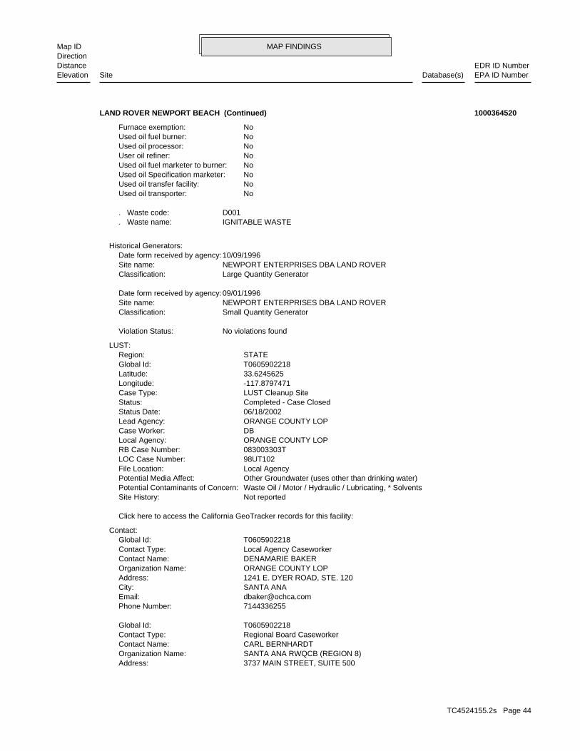
MAP FINDINGSMap IDDirection
EDR ID NumberDistanceEPA ID NumberDatabase(s)SiteElevation
3737 MAIN STREET, SUITE 500Address: SANTA ANA RWQCB (REGION 8)Organization Name: CARL BERNHARDTContact Name: Regional Board CaseworkerContact Type: T0605902218Global Id:
7144336255Phone Number: [email protected]: SANTA ANACity: 1241 E. DYER ROAD, STE. 120Address: ORANGE COUNTY LOPOrganization Name: DENAMARIE BAKERContact Name: Local Agency CaseworkerContact Type: T0605902218Global Id:
Contact:
Click here to access the California GeoTracker records for this facility:
Not reportedSite History: Waste Oil / Motor / Hydraulic / Lubricating, * SolventsPotential Contaminants of Concern: Other Groundwater (uses other than drinking water)Potential Media Affect: Local AgencyFile Location: 98UT102LOC Case Number: 083003303TRB Case Number: ORANGE COUNTY LOPLocal Agency: DBCase Worker: ORANGE COUNTY LOPLead Agency: 06/18/2002Status Date: Completed - Case ClosedStatus: LUST Cleanup SiteCase Type: -117.8797471Longitude: 33.6245625Latitude: T0605902218Global Id: STATERegion:
LUST:
No violations foundViolation Status:
Small Quantity GeneratorClassification: NEWPORT ENTERPRISES DBA LAND ROVERSite name: 09/01/1996Date form received by agency:
Large Quantity GeneratorClassification: NEWPORT ENTERPRISES DBA LAND ROVERSite name: 10/09/1996Date form received by agency:
Historical Generators:
IGNITABLE WASTE. Waste name: D001. Waste code:
NoUsed oil transporter: NoUsed oil transfer facility: NoUsed oil Specification marketer: NoUsed oil fuel marketer to burner: NoUser oil refiner: NoUsed oil processor: NoUsed oil fuel burner: NoFurnace exemption:
LAND ROVER NEWPORT BEACH (Continued) 1000364520
TC4524155.2s Page 44
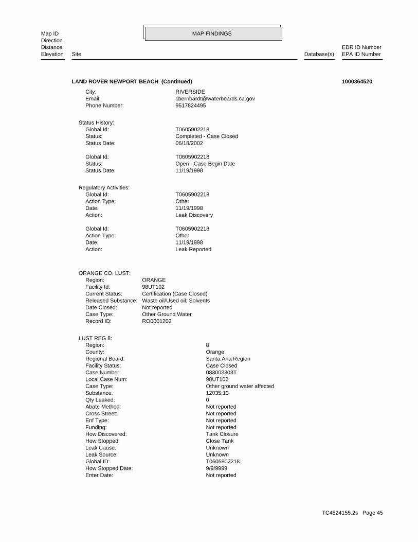
MAP FINDINGSMap IDDirection
EDR ID NumberDistanceEPA ID NumberDatabase(s)SiteElevation
Not reportedEnter Date: 9/9/9999How Stopped Date: T0605902218Global ID: UnknownLeak Source: UnknownLeak Cause: Close TankHow Stopped: Tank ClosureHow Discovered: Not reportedFunding: Not reportedEnf Type: Not reportedCross Street: Not reportedAbate Method: 0Qty Leaked: 12035,13Substance: Other ground water affectedCase Type: 98UT102Local Case Num: 083003303TCase Number: Case ClosedFacility Status: Santa Ana RegionRegional Board: OrangeCounty: 8Region:
LUST REG 8:
RO0001202Record ID: Other Ground WaterCase Type: Not reportedDate Closed: Waste oil/Used oil; SolventsReleased Substance: Certification (Case Closed)Current Status: 98UT102Facility Id: ORANGERegion:
ORANGE CO. LUST:
Leak ReportedAction: 11/19/1998Date: OtherAction Type: T0605902218Global Id:
Leak DiscoveryAction: 11/19/1998Date: OtherAction Type: T0605902218Global Id:
Regulatory Activities:
11/19/1998Status Date: Open - Case Begin DateStatus: T0605902218Global Id:
06/18/2002Status Date: Completed - Case ClosedStatus: T0605902218Global Id:
Status History:
9517824495Phone Number: [email protected]: RIVERSIDECity:
LAND ROVER NEWPORT BEACH (Continued) 1000364520
TC4524155.2s Page 45

MAP FINDINGSMap IDDirection
EDR ID NumberDistanceEPA ID NumberDatabase(s)SiteElevation
001Tank Num:
0002Total Tanks: NEWPORT BEACH, CA 92660Owner City,St,Zip: 1540 JAMBOREE RD.Owner Address: STERLING MOTORS, INC.Owner Name: 7146406444Telephone: ROBERT H. NOLANDContact Name: AUTOMOTIVE DEALERSHIOther Type: OtherFacility Type: 00000064597Facility ID: STATERegion:
HIST UST:
-117.878343Longitude: 33.6253229Latitude: ORANGE COUNTYPermitting Agency: 17768Facility ID:
UST:
Not reportedSummary: Not reportedWork Suspended: Not reportedCleanup Fund Id: Not reportedPriority: MARBeneficial: Not reportedHydr Basin #: 30000LLocal Agency: Local AgencyLead Agency: JKStaff Initials: CABStaff: *MTBE Class: Not Required to be Tested.MTBE Tested: 0MTBE Fuel: Not reportedMax MTBE Soil: 0MTBE Concentration: Not reportedMax MTBE GW: Not reportedMTBE Date: -117.8797471Longitude: 33.6245625Latitude: LUSTOversite Program: Not reportedInterim: Not reportedFacility Contact: Not reportedOperator: Not reportedSoil Qualifies: Not reportedGW Qualifies: Not reportedEnter Date: Not reportedDate Post Remedial Action Monitoring: Not reportedDate Remedial Action Underway: Not reportedDate Remediation Plan Submitted: Not reportedDate Pollution Characterization Began: Not reportedDate Prelim Assessment Workplan Submitted: 6/18/2002Close Date: Not reportedEnforcement Date: 11/19/1998Discover Date: Not reportedDate Preliminary Assessment Began: Not reportedDate Confirmation of Leak Began:
LAND ROVER NEWPORT BEACH (Continued) 1000364520
TC4524155.2s Page 46

MAP FINDINGSMap IDDirection
EDR ID NumberDistanceEPA ID NumberDatabase(s)SiteElevation
Conservation and Recovery Act (RCRA) program through the tracking ofRCRAInfo is a national information system that supports the Resource
facilities.generators, transporters, and treatment, storage, and disposalprovides California with information on hazardous waste shipments forCalifornia Hazardous Waste Tracking System - Datamart (HWTS-DATAMART) Environmental Interest/Information System
110002758846Registry ID:
FINDS:
WASTE (OR SLOP) OILReleased Chemical: Closure certification issuedClosure Type: CLOSED 2/3/2009Current Status: RO0003203Record ID: ORANGERegion: 03IC016Case ID:
Orange Co. Industrial Site:
ActiveStatus: Not reportedComments: Not reportedEPA ID: Not reportedNPDES Number: Not reportedDUNs Number: Not reportedContact Phone: Not reportedContact: NEWPORT BEACH 92660Mailing City,St,Zip: Not reportedMailing Address 2: 604 PRODUCTION PLMailing Address: Not reportedMail To: 7146406444Facility Phone: Not reportedSIC Code: Not reportedCortese Code: Not reportedRegulated ID: UTNKARegulated By: 30017016Facility ID:
CA FID UST:
NoneLeak Detection: Not reportedContainer Construction Thickness: WASTE OILType of Fuel: WASTETank Used for: 00001000Tank Capacity: 1975Year Installed: 2Container Num: 002Tank Num:
NoneLeak Detection: Not reportedContainer Construction Thickness: UNLEADEDType of Fuel: PRODUCTTank Used for: 00002000Tank Capacity: 1975Year Installed: 1Container Num:
LAND ROVER NEWPORT BEACH (Continued) 1000364520
TC4524155.2s Page 47

MAP FINDINGSMap IDDirection
EDR ID NumberDistanceEPA ID NumberDatabase(s)SiteElevation
083003303TReg Id: LTNKAReg By: 30Facility County Code: CORTESERegion:
HIST CORTESE:
corrective action activities required under RCRA.program staff to track the notification, permit, compliance, andand treat, store, or dispose of hazardous waste. RCRAInfo allows RCRAevents and activities related to facilities that generate, transport,
LAND ROVER NEWPORT BEACH (Continued) 1000364520
9513206375Phone Number: [email protected]: RIVERSIDECity: 3737 MAIN STREET, SUITE 500Address: SANTA ANA RWQCB (REGION 8)Organization Name: ROSE SCOTTContact Name: Regional Board CaseworkerContact Type: T0605900840Global Id:
7144336255Phone Number: [email protected]: SANTA ANACity: 1241 E. DYER ROAD, STE. 120Address: ORANGE COUNTY LOPOrganization Name: DENAMARIE BAKERContact Name: Local Agency CaseworkerContact Type: T0605900840Global Id:
Contact:
Click here to access the California GeoTracker records for this facility:
Not reportedSite History: GasolinePotential Contaminants of Concern: Other Groundwater (uses other than drinking water)Potential Media Affect: Local AgencyFile Location: 88UT150LOC Case Number: 083001065TRB Case Number: ORANGE COUNTY LOPLocal Agency: DBCase Worker: ORANGE COUNTY LOPLead Agency: 08/30/1994Status Date: Completed - Case ClosedStatus: LUST Cleanup SiteCase Type: -117.880391Longitude: 33.623322Latitude: T0605900840Global Id: STATERegion:
LUST:
1734 ft.0.328 mi. CA HIST CORTESE
Relative:Higher
Actual:130 ft.
1/4-1/2 CA EMINEWPORT BEACH, CA 92660SSW CA CHMIRS870 SANTA BARBARA DR N/A24 CA LUSTNEWPORT BEACH POLICE DEPT S100279962
TC4524155.2s Page 48

MAP FINDINGSMap IDDirection
EDR ID NumberDistanceEPA ID NumberDatabase(s)SiteElevation
[email protected]: RIVERSIDECity: 3737 MAIN STREET, SUITE 500Address: SANTA ANA RWQCB (REGION 8)Organization Name: TOM E. MBEKE-EKANEMContact Name: Regional Board CaseworkerContact Type: T0605901955Global Id:
7144336255Phone Number: [email protected]: SANTA ANACity: 1241 E. DYER ROAD, STE. 120Address: ORANGE COUNTY LOPOrganization Name: DENAMARIE BAKERContact Name: Local Agency CaseworkerContact Type: T0605901955Global Id:
Contact:
Click here to access the California GeoTracker records for this facility:
Not reportedSite History: GasolinePotential Contaminants of Concern: Other Groundwater (uses other than drinking water)Potential Media Affect: Local Agency WarehouseFile Location: 02UT019LOC Case Number: 083002849TRB Case Number: ORANGE COUNTY LOPLocal Agency: DBCase Worker: ORANGE COUNTY LOPLead Agency: 10/28/2004Status Date: Completed - Case ClosedStatus: LUST Cleanup SiteCase Type: -117.8800141Longitude: 33.6205066Latitude: T0605901955Global Id: STATERegion:
Leak ReportedAction: 08/31/1988Date: OtherAction Type: T0605900840Global Id:
Leak DiscoveryAction: 08/31/1988Date: OtherAction Type: T0605900840Global Id:
Regulatory Activities:
08/31/1988Status Date: Open - Case Begin DateStatus: T0605900840Global Id:
08/30/1994Status Date: Completed - Case ClosedStatus: T0605900840Global Id:
Status History:
NEWPORT BEACH POLICE DEPT (Continued) S100279962
TC4524155.2s Page 49
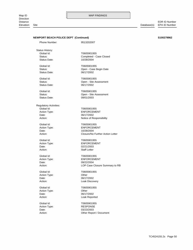
MAP FINDINGSMap IDDirection
EDR ID NumberDistanceEPA ID NumberDatabase(s)SiteElevation
Other Report / DocumentAction: 03/23/2003Date: RESPONSEAction Type: T0605901955Global Id:
Leak ReportedAction: 06/17/2002Date: OtherAction Type: T0605901955Global Id:
Leak DiscoveryAction: 06/17/2002Date: OtherAction Type: T0605901955Global Id:
LOP Case Closure Summary to RBAction: 09/22/2004Date: ENFORCEMENTAction Type: T0605901955Global Id:
Staff LetterAction: 02/21/2003Date: ENFORCEMENTAction Type: T0605901955Global Id:
Closure/No Further Action LetterAction: 10/28/2004Date: ENFORCEMENTAction Type: T0605901955Global Id:
Notice of ResponsibilityAction: 06/17/2002Date: ENFORCEMENTAction Type: T0605901955Global Id:
Regulatory Activities:
09/01/2003Status Date: Open - Site AssessmentStatus: T0605901955Global Id:
06/17/2002Status Date: Open - Site AssessmentStatus: T0605901955Global Id:
06/17/2002Status Date: Open - Case Begin DateStatus: T0605901955Global Id:
10/28/2004Status Date: Completed - Case ClosedStatus: T0605901955Global Id:
Status History:
9513202007Phone Number:
NEWPORT BEACH POLICE DEPT (Continued) S100279962
TC4524155.2s Page 50
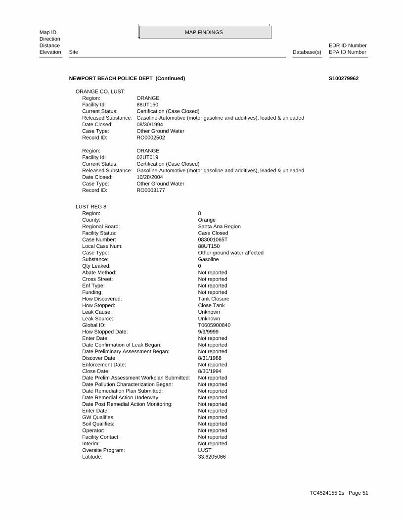
MAP FINDINGSMap IDDirection
EDR ID NumberDistanceEPA ID NumberDatabase(s)SiteElevation
33.6205066Latitude: LUSTOversite Program: Not reportedInterim: Not reportedFacility Contact: Not reportedOperator: Not reportedSoil Qualifies: Not reportedGW Qualifies: Not reportedEnter Date: Not reportedDate Post Remedial Action Monitoring: Not reportedDate Remedial Action Underway: Not reportedDate Remediation Plan Submitted: Not reportedDate Pollution Characterization Began: Not reportedDate Prelim Assessment Workplan Submitted: 8/30/1994Close Date: Not reportedEnforcement Date: 8/31/1988Discover Date: Not reportedDate Preliminary Assessment Began: Not reportedDate Confirmation of Leak Began: Not reportedEnter Date: 9/9/9999How Stopped Date: T0605900840Global ID: UnknownLeak Source: UnknownLeak Cause: Close TankHow Stopped: Tank ClosureHow Discovered: Not reportedFunding: Not reportedEnf Type: Not reportedCross Street: Not reportedAbate Method: 0Qty Leaked: GasolineSubstance: Other ground water affectedCase Type: 88UT150Local Case Num: 083001065TCase Number: Case ClosedFacility Status: Santa Ana RegionRegional Board: OrangeCounty: 8Region:
LUST REG 8:
RO0003177Record ID: Other Ground WaterCase Type: 10/28/2004Date Closed: Gasoline-Automotive (motor gasoline and additives), leaded & unleadedReleased Substance: Certification (Case Closed)Current Status: 02UT019Facility Id: ORANGERegion:
RO0002502Record ID: Other Ground WaterCase Type: 08/30/1994Date Closed: Gasoline-Automotive (motor gasoline and additives), leaded & unleadedReleased Substance: Certification (Case Closed)Current Status: 88UT150Facility Id: ORANGERegion:
ORANGE CO. LUST:
NEWPORT BEACH POLICE DEPT (Continued) S100279962
TC4524155.2s Page 51

MAP FINDINGSMap IDDirection
EDR ID NumberDistanceEPA ID NumberDatabase(s)SiteElevation
33.6205066Latitude: LUSTOversite Program: Not reportedInterim: Not reportedFacility Contact: Not reportedOperator: =Soil Qualifies: =GW Qualifies: Not reportedEnter Date: Not reportedDate Post Remedial Action Monitoring: Not reportedDate Remedial Action Underway: Not reportedDate Remediation Plan Submitted: 9/1/2003Date Pollution Characterization Began: Not reportedDate Prelim Assessment Workplan Submitted: 10/28/2004Close Date: Not reportedEnforcement Date: 6/17/2002Discover Date: 1/1/1965Date Preliminary Assessment Began: Not reportedDate Confirmation of Leak Began: Not reportedEnter Date: 9/9/9999How Stopped Date: T0605901955Global ID: UnknownLeak Source: UnknownLeak Cause: Close TankHow Stopped: Tank ClosureHow Discovered: Not reportedFunding: SELEnf Type: Not reportedCross Street: Not reportedAbate Method: 0Qty Leaked: GasolineSubstance: Other ground water affectedCase Type: 02UT019Local Case Num: 083002849TCase Number: Preliminary site assessment underwayFacility Status: Santa Ana RegionRegional Board: OrangeCounty: 8Region:
Not reportedSummary: Not reportedWork Suspended: Not reportedCleanup Fund Id: Not reportedPriority: MUNBeneficial: Not reportedHydr Basin #: 30000LLocal Agency: Local AgencyLead Agency: JKStaff Initials: RSStaff: *MTBE Class: Site NOT Tested for MTBE.Includes Unknown and Not Analyzed.MTBE Tested: 1MTBE Fuel: Not reportedMax MTBE Soil: 0MTBE Concentration: Not reportedMax MTBE GW: Not reportedMTBE Date: -117.8800141Longitude:
NEWPORT BEACH POLICE DEPT (Continued) S100279962
TC4524155.2s Page 52

MAP FINDINGSMap IDDirection
EDR ID NumberDistanceEPA ID NumberDatabase(s)SiteElevation
Not reportedMeasure: Not reportedType: Not reportedWhat Happened: Not reportedContainment: Not reportedCleanup By: Not reportedSpill Site: Not reportedWaterway: Not reportedWaterway Involved: 714 644-3103Facility Telephone: 11-MAY-90Report Date: B/C A. WAGNERReporting Officer Name/ID: Not reportedCompany Name: Not reportedCA DOT PUC/ICC Number: Not reportedVehicle Id Number: Not reportedVehicle State: Not reportedVehicle License Number: Not reportedVehicle Make/year: 0Others Number Of Fatalities: 0Others Number Of Injuries: 0Others Number Of Decontaminated: 0Responding Agency Personel # Of Fatalities: 0Responding Agency Personel # Of Injuries: 0Resp Agncy Personel # Of Decontaminated: NMore Than Two Substances Involved?: CProperty Management: Not reportedEstimated Temperature: 962Surrounding Area: 1500Time Completed: 903Time Notified: 002816Agency Incident Number: 30055Agency Id Number: 500Property Use: 13-FEB-90Date Completed: Not reportedOES Time: Not reportedOES Date: Not reportedOES notification: 098016OES Incident Number:
CHMIRS:
Not reportedSummary: Not reportedWork Suspended: Not reportedCleanup Fund Id: Not reportedPriority: MAR,NAV,REC-1,REC-2,SHELL,SPWN,WET,WILDBeneficial: Not reportedHydr Basin #: 30000LLocal Agency: Local AgencyLead Agency: JKStaff Initials: TMEStaff: *MTBE Class: MTBE Detected. Site tested for MTBE & MTBE detectedMTBE Tested: 1MTBE Fuel: 398Max MTBE Soil: 0MTBE Concentration: 206Max MTBE GW: 12/29/2003MTBE Date: -117.8800141Longitude:
NEWPORT BEACH POLICE DEPT (Continued) S100279962
TC4524155.2s Page 53

MAP FINDINGSMap IDDirection
EDR ID NumberDistanceEPA ID NumberDatabase(s)SiteElevation
083001065TReg Id: LTNKAReg By: 30Facility County Code: CORTESERegion:
HIST CORTESE:
0Part. Matter 10 Micrometers & Smllr Tons/Yr: 0Particulate Matter Tons/Yr: 0SOX - Oxides of Sulphur Tons/Yr: 0NOX - Oxides of Nitrogen Tons/Yr: 0Carbon Monoxide Emissions Tons/Yr: 0Reactive Organic Gases Tons/Yr: 0Total Organic Hydrocarbon Gases Tons/Yr: Not reportedConsolidated Emission Reporting Rule: Not reportedCommunity Health Air Pollution Info System: SOUTH COAST AQMDAir District Name: 9199SIC Code: SCAir District Name: 67517Facility ID: SCAir Basin: 30County Code: 1990Year:
EMI:
Not reportedDescription: YComments: Not reportedFatals: Not reportedInjuries: Not reportedEvacs: Not reported#3 Vessel >= 300 Tons: Not reported#2 Vessel >= 300 Tons: Not reported#1 Vessel >= 300 Tons: Not reported#3 Pipeline: Not reported#2 Pipeline: Not reported#1 Pipeline: Not reportedNumber of Fatalities: Not reportedNumber of Injuries: Not reportedEvacuations: Not reportedSubstance #3: Not reportedSubstance #2: Not reportedUnknown: Not reportedSubstance: 26-JUN-91E Date: Not reportedSite Type: Not reportedContained: Not reportedAmount: Not reportedAdmin Agency: 13-FEB-90Incident Date: Not reportedAgency: 88-92Year: Not reportedDate/Time: Not reportedOther:
NEWPORT BEACH POLICE DEPT (Continued) S100279962
TC4524155.2s Page 54

MAP FINDINGSMap IDDirection
EDR ID NumberDistanceEPA ID NumberDatabase(s)SiteElevation
NoUnderground injection activity: NoTreater, storer or disposer of HW: NoTransporter of hazardous waste: NoRecycler of hazardous waste: NoMixed waste (haz. and radioactive): NoU.S. importer of hazardous waste:
Handler Activities Summary:
Not reportedOwner/Op end date: Not reportedOwner/Op start date: OperatorOwner/Operator Type: PrivateLegal status: (415) 555-1212Owner/operator telephone: Not reportedOwner/operator country: NOT REQUIRED, ME 99999 NOT REQUIREDOwner/operator address: NOT REQUIREDOwner/operator name:
Not reportedOwner/Op end date: Not reportedOwner/Op start date: OwnerOwner/Operator Type: PrivateLegal status: (415) 555-1212Owner/operator telephone: Not reportedOwner/operator country: NOT REQUIRED, ME 99999 NOT REQUIREDOwner/operator address: FOUR SEASONS CORPOwner/operator name:
Owner/Operator Summary:
hazardous waste at any time waste during any calendar month, and accumulates more than 1000 kg of hazardous waste at any time; or generates 100 kg or less of hazardous waste during any calendar month and accumulates less than 6000 kg of Handler: generates more than 100 and less than 1000 kg of hazardousDescription: Small Small Quantity GeneratorClassification: 09EPA Region: Not reportedContact email: Not reportedContact telephone: USContact country: Not reported Not reportedContact address: Not reportedContact: NEWPORT BEACH, CA 92660 690 NEWPORT CENTER DRMailing address: CAD981635782EPA ID: NEWPORT BEACH, CA 92660 690 NEWPORT CENTERFacility address: FOUR SEASONS HOTELFacility name: 09/01/1996Date form received by agency:
RCRA-SQG:
CA HIST CORTESEFINDS
2640 ft. CA FID UST0.500 mi. CA SWEEPS UST
Relative:Higher
Actual:225 ft.
1/4-1/2 CA USTNEWPORT BEACH, CA 92660SSE CA LUST690 NEWPORT CENTER CAD98163578225 RCRA-SQGFOUR SEASONS HOTEL 1000351769
TC4524155.2s Page 55

MAP FINDINGSMap IDDirection
EDR ID NumberDistanceEPA ID NumberDatabase(s)SiteElevation
7144336255Phone Number: [email protected]: SANTA ANACity: 1241 E. DYER ROAD, STE. 120Address: ORANGE COUNTY LOPOrganization Name: DENAMARIE BAKERContact Name: Local Agency CaseworkerContact Type: T0605902093Global Id:
9513202007Phone Number: [email protected]: RIVERSIDECity: 3737 MAIN STREET, SUITE 500Address: SANTA ANA RWQCB (REGION 8)Organization Name: TOM E. MBEKE-EKANEMContact Name: Regional Board CaseworkerContact Type: T0605902093Global Id:
Contact:
Click here to access the California GeoTracker records for this facility:
submitted by consultants for the responsible party. accuracy of any professional interpretations provided in reports GeoTracker for site history. Orange County is not responsible for the Please refer to recent Site Documents or Monitoring Reports inSite History: DieselPotential Contaminants of Concern: Other Groundwater (uses other than drinking water)Potential Media Affect: Local AgencyFile Location: 97UT041LOC Case Number: 083003073TRB Case Number: ORANGE COUNTY LOPLocal Agency: DBCase Worker: ORANGE COUNTY LOPLead Agency: 01/28/2015Status Date: Completed - Case ClosedStatus: LUST Cleanup SiteCase Type: -117.875762Longitude: 33.6194517Latitude: T0605902093Global Id: STATERegion:
LUST:
No violations foundViolation Status:
Large Quantity GeneratorClassification: FOUR SEASONS HOTELSite name: 12/15/1986Date form received by agency:
Historical Generators:
NoUsed oil transporter: NoUsed oil transfer facility: NoUsed oil Specification marketer: NoUsed oil fuel marketer to burner: NoUser oil refiner: NoUsed oil processor: NoUsed oil fuel burner: NoFurnace exemption: NoOn-site burner exemption:
FOUR SEASONS HOTEL (Continued) 1000351769
TC4524155.2s Page 56
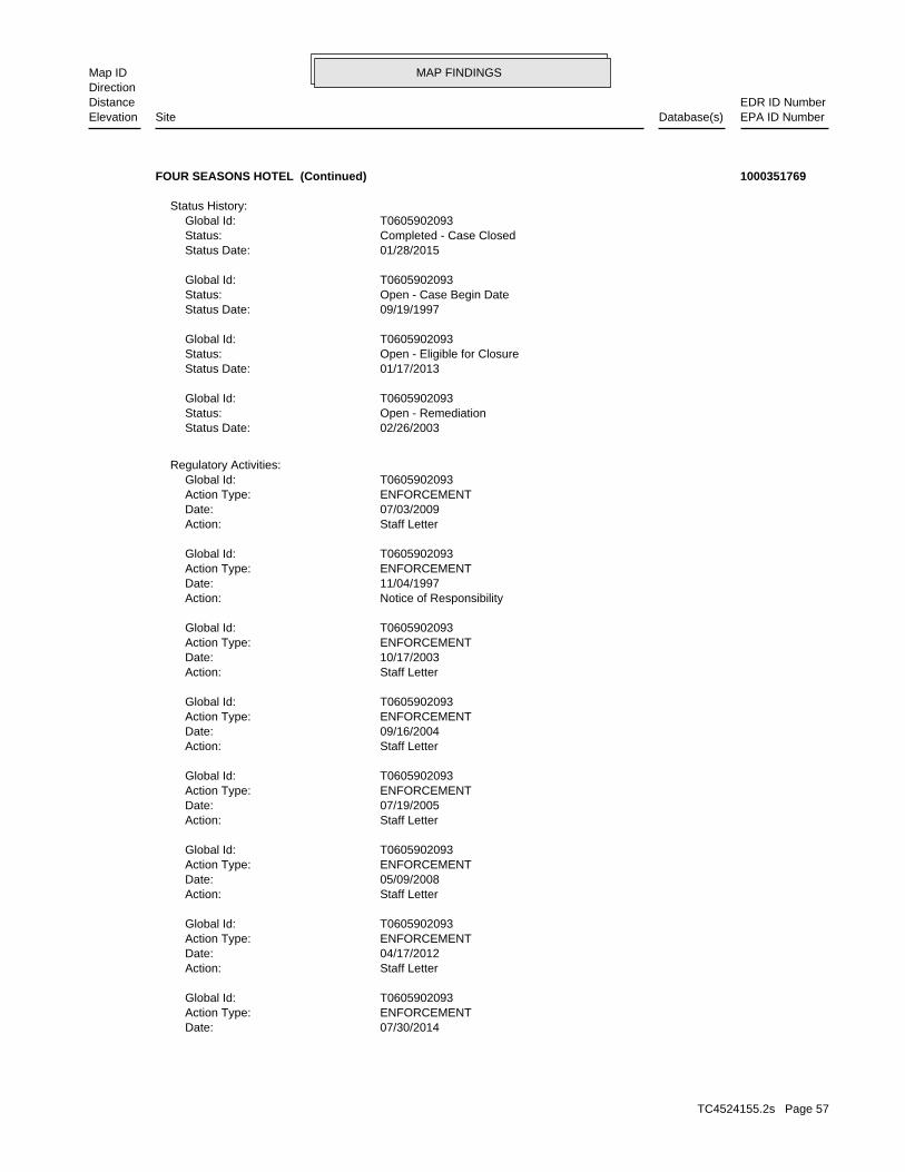
MAP FINDINGSMap IDDirection
EDR ID NumberDistanceEPA ID NumberDatabase(s)SiteElevation
07/30/2014Date: ENFORCEMENTAction Type: T0605902093Global Id:
Staff LetterAction: 04/17/2012Date: ENFORCEMENTAction Type: T0605902093Global Id:
Staff LetterAction: 05/09/2008Date: ENFORCEMENTAction Type: T0605902093Global Id:
Staff LetterAction: 07/19/2005Date: ENFORCEMENTAction Type: T0605902093Global Id:
Staff LetterAction: 09/16/2004Date: ENFORCEMENTAction Type: T0605902093Global Id:
Staff LetterAction: 10/17/2003Date: ENFORCEMENTAction Type: T0605902093Global Id:
Notice of ResponsibilityAction: 11/04/1997Date: ENFORCEMENTAction Type: T0605902093Global Id:
Staff LetterAction: 07/03/2009Date: ENFORCEMENTAction Type: T0605902093Global Id:
Regulatory Activities:
02/26/2003Status Date: Open - RemediationStatus: T0605902093Global Id:
01/17/2013Status Date: Open - Eligible for ClosureStatus: T0605902093Global Id:
09/19/1997Status Date: Open - Case Begin DateStatus: T0605902093Global Id:
01/28/2015Status Date: Completed - Case ClosedStatus: T0605902093Global Id:
Status History:
FOUR SEASONS HOTEL (Continued) 1000351769
TC4524155.2s Page 57

MAP FINDINGSMap IDDirection
EDR ID NumberDistanceEPA ID NumberDatabase(s)SiteElevation
Staff LetterAction: 09/30/2014Date: ENFORCEMENTAction Type: T0605902093Global Id:
Staff LetterAction: 01/17/2013Date: ENFORCEMENTAction Type: T0605902093Global Id:
Staff LetterAction: 12/29/2009Date: ENFORCEMENTAction Type: T0605902093Global Id:
Leak ReportedAction: 07/11/1997Date: OtherAction Type: T0605902093Global Id:
Other (Use Description Field)Action: 07/15/2008Date: REMEDIATIONAction Type: T0605902093Global Id:
Notification - Public Participation DocumentAction: 07/30/2014Date: ENFORCEMENTAction Type: T0605902093Global Id:
Staff LetterAction: 01/07/2011Date: ENFORCEMENTAction Type: T0605902093Global Id:
Free Product RemovalAction: 10/20/1998Date: REMEDIATIONAction Type: T0605902093Global Id:
Leak DiscoveryAction: 07/10/1997Date: OtherAction Type: T0605902093Global Id:
Closure/No Further Action LetterAction: 01/28/2015Date: ENFORCEMENTAction Type: T0605902093Global Id:
Staff LetterAction: 07/21/2008Date: ENFORCEMENTAction Type: T0605902093Global Id:
Notification - Public Notice of Case ClosureAction:
FOUR SEASONS HOTEL (Continued) 1000351769
TC4524155.2s Page 58
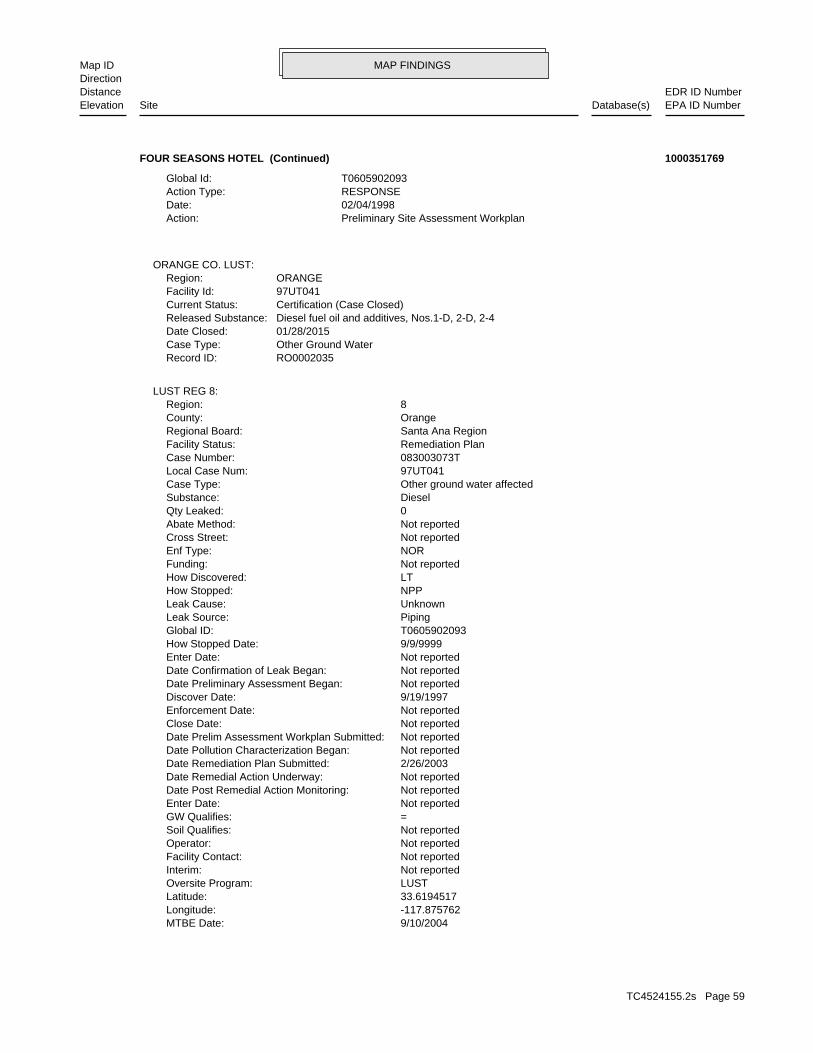
MAP FINDINGSMap IDDirection
EDR ID NumberDistanceEPA ID NumberDatabase(s)SiteElevation
9/10/2004MTBE Date: -117.875762Longitude: 33.6194517Latitude: LUSTOversite Program: Not reportedInterim: Not reportedFacility Contact: Not reportedOperator: Not reportedSoil Qualifies: =GW Qualifies: Not reportedEnter Date: Not reportedDate Post Remedial Action Monitoring: Not reportedDate Remedial Action Underway: 2/26/2003Date Remediation Plan Submitted: Not reportedDate Pollution Characterization Began: Not reportedDate Prelim Assessment Workplan Submitted: Not reportedClose Date: Not reportedEnforcement Date: 9/19/1997Discover Date: Not reportedDate Preliminary Assessment Began: Not reportedDate Confirmation of Leak Began: Not reportedEnter Date: 9/9/9999How Stopped Date: T0605902093Global ID: PipingLeak Source: UnknownLeak Cause: NPPHow Stopped: LTHow Discovered: Not reportedFunding: NOREnf Type: Not reportedCross Street: Not reportedAbate Method: 0Qty Leaked: DieselSubstance: Other ground water affectedCase Type: 97UT041Local Case Num: 083003073TCase Number: Remediation PlanFacility Status: Santa Ana RegionRegional Board: OrangeCounty: 8Region:
LUST REG 8:
RO0002035Record ID: Other Ground WaterCase Type: 01/28/2015Date Closed: Diesel fuel oil and additives, Nos.1-D, 2-D, 2-4Released Substance: Certification (Case Closed)Current Status: 97UT041Facility Id: ORANGERegion:
ORANGE CO. LUST:
Preliminary Site Assessment WorkplanAction: 02/04/1998Date: RESPONSEAction Type: T0605902093Global Id:
FOUR SEASONS HOTEL (Continued) 1000351769
TC4524155.2s Page 59

MAP FINDINGSMap IDDirection
EDR ID NumberDistanceEPA ID NumberDatabase(s)SiteElevation
NEWPORT BEACH 92660Mailing City,St,Zip: Not reportedMailing Address 2: 690 NEWPORT CENTER DRMailing Address: Not reportedMail To: 7147590808Facility Phone: Not reportedSIC Code: Not reportedCortese Code: Not reportedRegulated ID: UTNKARegulated By: 30006786Facility ID:
CA FID UST:
1Number Of Tanks: DIESELContent: PSTG: M.V. FUELTank Use: Not reportedActive Date: 1000Capacity: ATank Status: 30-000-004052-000001SWRCB Tank Id: Not reportedOwner Tank Id: 02-29-88Created Date: 09-15-92Action Date: 09-30-92Referral Date: 44-016110Board Of Equalization: 9Number: 4052Comp Number: ActiveStatus:
SWEEPS UST:
FA0024638Facility ID:ORANGE CO. UST:
-117.8738808Longitude: 33.6211143Latitude: ORANGE COUNTYPermitting Agency: 4052Facility ID:
UST:
Not reportedSummary: Not reportedWork Suspended: Not reportedCleanup Fund Id: Not reportedPriority: EST,MAR,RARE,SHELL,SPWN,WET,WILDBeneficial: Not reportedHydr Basin #: 30000LLocal Agency: Local AgencyLead Agency: JKStaff Initials: TMEStaff: *MTBE Class: MTBE Detected. Site tested for MTBE & MTBE detectedMTBE Tested: 0MTBE Fuel: Not reportedMax MTBE Soil: 0MTBE Concentration: 270Max MTBE GW:
FOUR SEASONS HOTEL (Continued) 1000351769
TC4524155.2s Page 60
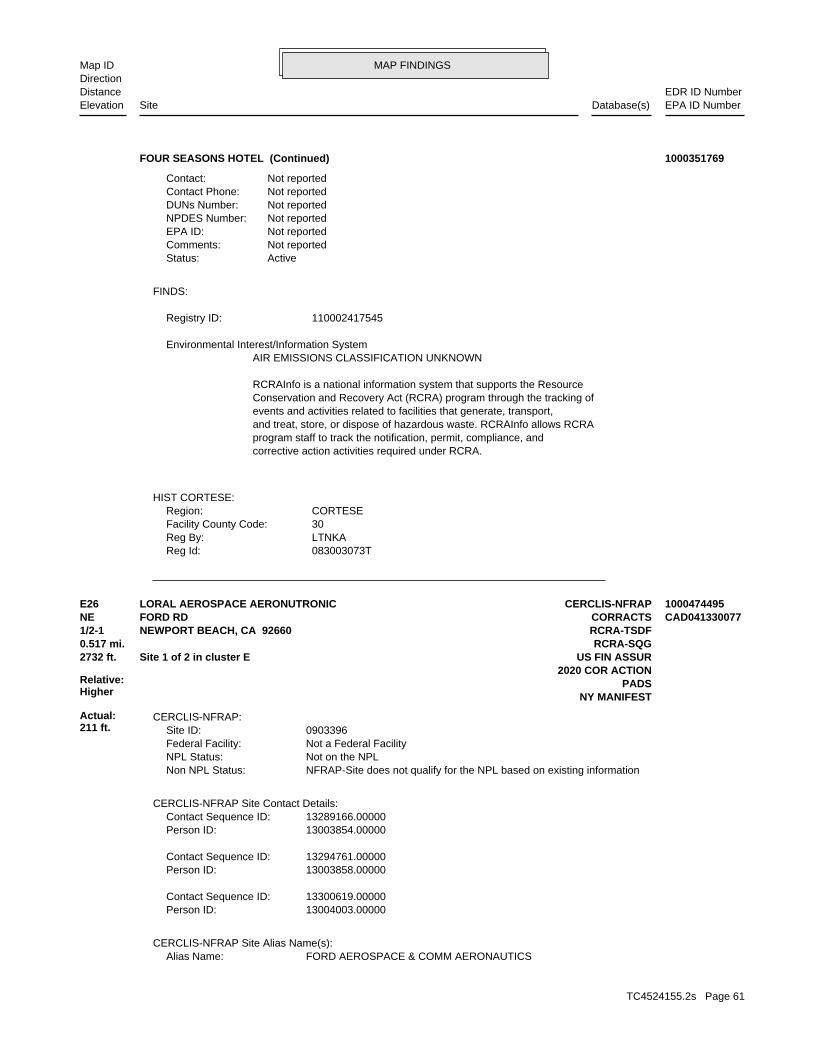
MAP FINDINGSMap IDDirection
EDR ID NumberDistanceEPA ID NumberDatabase(s)SiteElevation
083003073TReg Id: LTNKAReg By: 30Facility County Code: CORTESERegion:
HIST CORTESE:
corrective action activities required under RCRA.program staff to track the notification, permit, compliance, andand treat, store, or dispose of hazardous waste. RCRAInfo allows RCRAevents and activities related to facilities that generate, transport,Conservation and Recovery Act (RCRA) program through the tracking ofRCRAInfo is a national information system that supports the Resource
AIR EMISSIONS CLASSIFICATION UNKNOWN Environmental Interest/Information System
110002417545Registry ID:
FINDS:
ActiveStatus: Not reportedComments: Not reportedEPA ID: Not reportedNPDES Number: Not reportedDUNs Number: Not reportedContact Phone: Not reportedContact:
FOUR SEASONS HOTEL (Continued) 1000351769
FORD AEROSPACE & COMM AERONAUTICSAlias Name:CERCLIS-NFRAP Site Alias Name(s):
13004003.00000Person ID: 13300619.00000Contact Sequence ID:
13003858.00000Person ID: 13294761.00000Contact Sequence ID:
13003854.00000Person ID: 13289166.00000Contact Sequence ID:
CERCLIS-NFRAP Site Contact Details:
NFRAP-Site does not qualify for the NPL based on existing informationNon NPL Status: Not on the NPLNPL Status: Not a Federal FacilityFederal Facility: 0903396Site ID:
CERCLIS-NFRAP:
NY MANIFESTPADS
2020 COR ACTION2732 ft. US FIN ASSURSite 1 of 2 in cluster E0.517 mi. RCRA-SQG
Relative:Higher
Actual:211 ft.
1/2-1 RCRA-TSDFNEWPORT BEACH, CA 92660NE CORRACTSFORD RD CAD041330077E26 CERCLIS-NFRAPLORAL AEROSPACE AERONUTRONIC 1000474495
TC4524155.2s Page 61
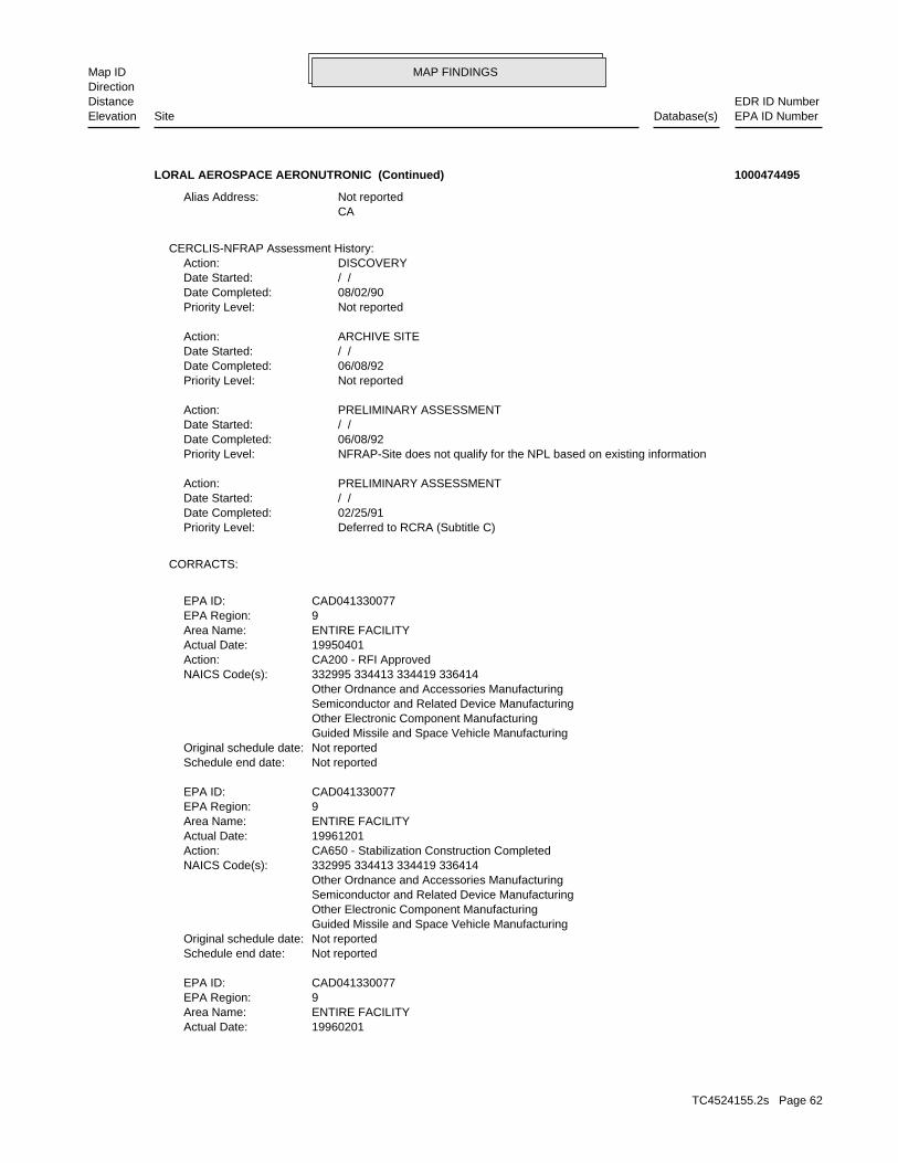
MAP FINDINGSMap IDDirection
EDR ID NumberDistanceEPA ID NumberDatabase(s)SiteElevation
19960201Actual Date: ENTIRE FACILITYArea Name: 9EPA Region: CAD041330077EPA ID:
Not reportedSchedule end date: Not reportedOriginal schedule date: Guided Missile and Space Vehicle Manufacturing Other Electronic Component Manufacturing Semiconductor and Related Device Manufacturing Other Ordnance and Accessories Manufacturing 332995 334413 334419 336414NAICS Code(s): CA650 - Stabilization Construction CompletedAction: 19961201Actual Date: ENTIRE FACILITYArea Name: 9EPA Region: CAD041330077EPA ID:
Not reportedSchedule end date: Not reportedOriginal schedule date: Guided Missile and Space Vehicle Manufacturing Other Electronic Component Manufacturing Semiconductor and Related Device Manufacturing Other Ordnance and Accessories Manufacturing 332995 334413 334419 336414NAICS Code(s): CA200 - RFI ApprovedAction: 19950401Actual Date: ENTIRE FACILITYArea Name: 9EPA Region: CAD041330077EPA ID:
CORRACTS:
Deferred to RCRA (Subtitle C)Priority Level: 02/25/91Date Completed: / /Date Started: PRELIMINARY ASSESSMENTAction:
NFRAP-Site does not qualify for the NPL based on existing informationPriority Level: 06/08/92Date Completed: / /Date Started: PRELIMINARY ASSESSMENTAction:
Not reportedPriority Level: 06/08/92Date Completed: / /Date Started: ARCHIVE SITEAction:
Not reportedPriority Level: 08/02/90Date Completed: / /Date Started: DISCOVERYAction:
CERCLIS-NFRAP Assessment History:
CA Not reportedAlias Address:
LORAL AEROSPACE AERONUTRONIC (Continued) 1000474495
TC4524155.2s Page 62

MAP FINDINGSMap IDDirection
EDR ID NumberDistanceEPA ID NumberDatabase(s)SiteElevation
Exposures Under Control has been verified CA725YE - Current Human Exposures Under Control, Yes, Current HumanAction: 19971203Actual Date: ENTIRE FACILITYArea Name: 9EPA Region: CAD041330077EPA ID:
Not reportedSchedule end date: Not reportedOriginal schedule date: Guided Missile and Space Vehicle Manufacturing Other Electronic Component Manufacturing Semiconductor and Related Device Manufacturing Other Ordnance and Accessories Manufacturing 332995 334413 334419 336414NAICS Code(s): information is needed to make a determination CA750IN - Migration of Contaminated Groundwater under Control, MoreAction: 19971203Actual Date: ENTIRE FACILITYArea Name: 9EPA Region: CAD041330077EPA ID:
Not reportedSchedule end date: Not reportedOriginal schedule date: Guided Missile and Space Vehicle Manufacturing Other Electronic Component Manufacturing Semiconductor and Related Device Manufacturing Other Ordnance and Accessories Manufacturing 332995 334413 334419 336414NAICS Code(s): source removal and/or treatment CA600SR - Stabilization Measures Implemented, Primary measure isAction: 19940101Actual Date: ENTIRE FACILITYArea Name: 9EPA Region: CAD041330077EPA ID:
Not reportedSchedule end date: Not reportedOriginal schedule date: Guided Missile and Space Vehicle Manufacturing Other Electronic Component Manufacturing Semiconductor and Related Device Manufacturing Other Ordnance and Accessories Manufacturing 332995 334413 334419 336414NAICS Code(s): CA100 - RFI ImpositionAction: 19920101Actual Date: ENTIRE FACILITYArea Name: 9EPA Region: CAD041330077EPA ID:
Not reportedSchedule end date: Not reportedOriginal schedule date: Guided Missile and Space Vehicle Manufacturing Other Electronic Component Manufacturing Semiconductor and Related Device Manufacturing Other Ordnance and Accessories Manufacturing 332995 334413 334419 336414NAICS Code(s): and treatment CA600GW - Stabilization Measures Implemented, Groundwater extractionAction:
LORAL AEROSPACE AERONUTRONIC (Continued) 1000474495
TC4524155.2s Page 63

MAP FINDINGSMap IDDirection
EDR ID NumberDistanceEPA ID NumberDatabase(s)SiteElevation
Other Ordnance and Accessories Manufacturing 332995 334413 334419 336414NAICS Code(s): Exposures Under Control has been verified CA725YE - Current Human Exposures Under Control, Yes, Current HumanAction: 20010309Actual Date: ENTIRE FACILITYArea Name: 9EPA Region: CAD041330077EPA ID:
Not reportedSchedule end date: 20010309Original schedule date: Guided Missile and Space Vehicle Manufacturing Other Electronic Component Manufacturing Semiconductor and Related Device Manufacturing Other Ordnance and Accessories Manufacturing 332995 334413 334419 336414NAICS Code(s): information is needed to make a determination CA750IN - Migration of Contaminated Groundwater under Control, MoreAction: 20010309Actual Date: ENTIRE FACILITYArea Name: 9EPA Region: CAD041330077EPA ID:
Not reportedSchedule end date: Not reportedOriginal schedule date: Guided Missile and Space Vehicle Manufacturing Other Electronic Component Manufacturing Semiconductor and Related Device Manufacturing Other Ordnance and Accessories Manufacturing 332995 334413 334419 336414NAICS Code(s): information is needed to make a determination CA750IN - Migration of Contaminated Groundwater under Control, MoreAction: 20010309Actual Date: ENTIRE FACILITYArea Name: 9EPA Region: CAD041330077EPA ID:
Not reportedSchedule end date: Not reportedOriginal schedule date: Guided Missile and Space Vehicle Manufacturing Other Electronic Component Manufacturing Semiconductor and Related Device Manufacturing Other Ordnance and Accessories Manufacturing 332995 334413 334419 336414NAICS Code(s): CA210 - CA Responsibility Referred To A Non-RCRA Federal AuthorityAction: 19971203Actual Date: ENTIRE FACILITYArea Name: 9EPA Region: CAD041330077EPA ID:
Not reportedSchedule end date: Not reportedOriginal schedule date: Guided Missile and Space Vehicle Manufacturing Other Electronic Component Manufacturing Semiconductor and Related Device Manufacturing Other Ordnance and Accessories Manufacturing 332995 334413 334419 336414NAICS Code(s):
LORAL AEROSPACE AERONUTRONIC (Continued) 1000474495
TC4524155.2s Page 64

MAP FINDINGSMap IDDirection
EDR ID NumberDistanceEPA ID NumberDatabase(s)SiteElevation
ENTIRE FACILITYArea Name: 9EPA Region: CAD041330077EPA ID:
Not reportedSchedule end date: Not reportedOriginal schedule date: Guided Missile and Space Vehicle Manufacturing Other Electronic Component Manufacturing Semiconductor and Related Device Manufacturing Other Ordnance and Accessories Manufacturing 332995 334413 334419 336414NAICS Code(s): corrective action priority CA075LO - CA Prioritization, Facility or area was assigned a lowAction: 19941014Actual Date: ENTIRE FACILITYArea Name: 9EPA Region: CAD041330077EPA ID:
Not reportedSchedule end date: Not reportedOriginal schedule date: Guided Missile and Space Vehicle Manufacturing Other Electronic Component Manufacturing Semiconductor and Related Device Manufacturing Other Ordnance and Accessories Manufacturing 332995 334413 334419 336414NAICS Code(s): considerations corrective action work at the facility, or other, administrative facility, the degree of risk, timing considerations, the status of (IN). Reasons for this conclusion may be the status of, closure at the inappropriate (NF) or (2) there is a lack of technical, information other than (1) it appears to be technically, infeasible or amenable to stabilization activity at the, present time for reasons CA225NR - Stabilization Measures Evaluation, This facility is, notAction: 19941014Actual Date: ENTIRE FACILITYArea Name: 9EPA Region: CAD041330077EPA ID:
Not reportedSchedule end date: Not reportedOriginal schedule date: Guided Missile and Space Vehicle Manufacturing Other Electronic Component Manufacturing Semiconductor and Related Device Manufacturing Other Ordnance and Accessories Manufacturing 332995 334413 334419 336414NAICS Code(s): Exposures Under Control has been verified CA725YE - Current Human Exposures Under Control, Yes, Current HumanAction: 20010309Actual Date: ENTIRE FACILITYArea Name: 9EPA Region: CAD041330077EPA ID:
Not reportedSchedule end date: 20010309Original schedule date: Guided Missile and Space Vehicle Manufacturing Other Electronic Component Manufacturing Semiconductor and Related Device Manufacturing
LORAL AEROSPACE AERONUTRONIC (Continued) 1000474495
TC4524155.2s Page 65

MAP FINDINGSMap IDDirection
EDR ID NumberDistanceEPA ID NumberDatabase(s)SiteElevation
Other Ordnance and Accessories Manufacturing 332995 334413 334419 336414NAICS Code(s): CA074HIAction: 19910125Actual Date: ENTIRE FACILITYArea Name: 9EPA Region: CAD041330077EPA ID:
Not reportedSchedule end date: Not reportedOriginal schedule date: Guided Missile and Space Vehicle Manufacturing Other Electronic Component Manufacturing Semiconductor and Related Device Manufacturing Other Ordnance and Accessories Manufacturing 332995 334413 334419 336414NAICS Code(s): CA050PA - RFA Completed, Assessment was a PA-PlusAction: 19910125Actual Date: ENTIRE FACILITYArea Name: 9EPA Region: CAD041330077EPA ID:
Not reportedSchedule end date: Not reportedOriginal schedule date: Guided Missile and Space Vehicle Manufacturing Other Electronic Component Manufacturing Semiconductor and Related Device Manufacturing Other Ordnance and Accessories Manufacturing 332995 334413 334419 336414NAICS Code(s): corrective action priority CA075HI - CA Prioritization, Facility or area was assigned a highAction: 19910125Actual Date: ENTIRE FACILITYArea Name: 9EPA Region: CAD041330077EPA ID:
Not reportedSchedule end date: Not reportedOriginal schedule date: Guided Missile and Space Vehicle Manufacturing Other Electronic Component Manufacturing Semiconductor and Related Device Manufacturing Other Ordnance and Accessories Manufacturing 332995 334413 334419 336414NAICS Code(s): CA029WQAction: 19910125Actual Date: ENTIRE FACILITYArea Name: 9EPA Region: CAD041330077EPA ID:
Not reportedSchedule end date: Not reportedOriginal schedule date: Guided Missile and Space Vehicle Manufacturing Other Electronic Component Manufacturing Semiconductor and Related Device Manufacturing Other Ordnance and Accessories Manufacturing 332995 334413 334419 336414NAICS Code(s): CA150 - RFI Workplan ApprovedAction: 19920217Actual Date:
LORAL AEROSPACE AERONUTRONIC (Continued) 1000474495
TC4524155.2s Page 66

MAP FINDINGSMap IDDirection
EDR ID NumberDistanceEPA ID NumberDatabase(s)SiteElevation
(313) 568-7660Owner/operator telephone: Not reportedOwner/operator country: CITY NOT REPORTED, MI 99999 300 RENAISSANCE CENTEROwner/operator address: FORD AEROSPACE & COMMUNICATIONS CORPOwner/operator name:
Owner/Operator Summary:
waste Handler is engaged in the treatment, storage or disposal of hazardousDescription: TSDFClassification: PrivateLand type: 09EPA Region: Not reportedContact email: Not reportedContact telephone: USContact country: Not reported Not reportedContact address: Not reportedContact: CAD041330077EPA ID: NEWPORT BEACH, CA 926588900 1000 FORD RDFacility address: FORD MOTOR COFacility name: 09/01/1996Date form received by agency:
RCRA-TSDF:
Not reportedSchedule end date: Not reportedOriginal schedule date: Guided Missile and Space Vehicle Manufacturing Other Electronic Component Manufacturing Semiconductor and Related Device Manufacturing Other Ordnance and Accessories Manufacturing 332995 334413 334419 336414NAICS Code(s): CA036WQAction: 19911031Actual Date: ENTIRE FACILITYArea Name: 9EPA Region: CAD041330077EPA ID:
Not reportedSchedule end date: Not reportedOriginal schedule date: Guided Missile and Space Vehicle Manufacturing Other Electronic Component Manufacturing Semiconductor and Related Device Manufacturing Other Ordnance and Accessories Manufacturing 332995 334413 334419 336414NAICS Code(s): CA049PAAction: 19910125Actual Date: ENTIRE FACILITYArea Name: 9EPA Region: CAD041330077EPA ID:
Not reportedSchedule end date: Not reportedOriginal schedule date: Guided Missile and Space Vehicle Manufacturing Other Electronic Component Manufacturing Semiconductor and Related Device Manufacturing
LORAL AEROSPACE AERONUTRONIC (Continued) 1000474495
TC4524155.2s Page 67

MAP FINDINGSMap IDDirection
EDR ID NumberDistanceEPA ID NumberDatabase(s)SiteElevation
CA029WQEvent: 01/25/1991Event date:
Corrective Action Summary:
Large Quantity GeneratorClassification: FORD AEROSPACE CORPORATIONSite name: 04/02/1990Date form received by agency:
Large Quantity GeneratorClassification: LORAL AERONUTRONICSite name: 02/29/1992Date form received by agency:
Large Quantity GeneratorClassification: LORAL AERONUTRONICSite name: 03/30/1994Date form received by agency:
Not a generator, verifiedClassification: FORD MOTOR COSite name: 04/07/1994Date form received by agency:
Small Quantity GeneratorClassification: FORD MOTOR COSite name: 09/01/1996Date form received by agency:
Historical Generators:
NoUsed oil transporter: NoUsed oil transfer facility: NoUsed oil Specification marketer: NoUsed oil fuel marketer to burner: NoUser oil refiner: NoUsed oil processor: NoUsed oil fuel burner: NoFurnace exemption: NoOn-site burner exemption: NoUnderground injection activity: NoTreater, storer or disposer of HW: NoTransporter of hazardous waste: NoRecycler of hazardous waste: NoMixed waste (haz. and radioactive): NoU.S. importer of hazardous waste:
Handler Activities Summary:
Not reportedOwner/Op end date: Not reportedOwner/Op start date: OwnerOwner/Operator Type: PrivateLegal status: (313) 594-3061Owner/operator telephone: Not reportedOwner/operator country: DEARBORN, MI 48120 15201 CENTURY DR STE 608Owner/operator address: FORD MOTOR COOwner/operator name:
Not reportedOwner/Op end date: Not reportedOwner/Op start date: OperatorOwner/Operator Type: PrivateLegal status:
LORAL AEROSPACE AERONUTRONIC (Continued) 1000474495
TC4524155.2s Page 68

MAP FINDINGSMap IDDirection
EDR ID NumberDistanceEPA ID NumberDatabase(s)SiteElevation
is needed to make a determination. Igration of Contaminated Groundwater under Control, More informationEvent: 12/03/1997Event date:
CA Responsibility Referred To A Non-RCRA Federal AuthorityEvent: 12/03/1997Event date:
Stabilization Construction CompletedEvent: 12/01/1996Event date:
treatment (e.g., to achieve groundwater containment, to achieve MCL). Stabilization Measures Implemented, Groundwater extraction andEvent: 02/01/1996Event date:
RFI ApprovedEvent: 04/01/1995Event date:
the facility, or other administrative considerations. risk, timing considerations, the status of corrective action work at conclusion may be the status of closure at the facility, the degree of there is a lack of technical information (IN). Reasons for this it appears to be technically infeasible or inappropriate (NF) or 2- stabilization activity at the present time for reasons other than 1- Stabilization Measures Evaluation,This facility is not amenable toEvent: 10/14/1994Event date:
action priority. CA Prioritization, Facility or area was assigned a low correctiveEvent: 10/14/1994Event date:
treatment, off-site treatment). and/or treatment (e.g., soil or waste excavation, in-situ soil Stabilization Measures Implemented, Primary measure is source removalEvent: 01/01/1994Event date:
RFI Workplan ApprovedEvent: 02/17/1992Event date:
RFI ImpositionEvent: 01/01/1992Event date:
CA036WQEvent: 10/31/1991Event date:
CA049PAEvent: 01/25/1991Event date:
RFA Completed, Assessment was a PA-Plus.Event: 01/25/1991Event date:
action priority. CA Prioritization, Facility or area was assigned a high correctiveEvent: 01/25/1991Event date:
CA074HIEvent: 01/25/1991Event date:
LORAL AEROSPACE AERONUTRONIC (Continued) 1000474495
TC4524155.2s Page 69

MAP FINDINGSMap IDDirection
EDR ID NumberDistanceEPA ID NumberDatabase(s)SiteElevation
02/23/1994 Enforcement action date: INITIAL 3008(A) COMPLIANCE Enforcement action: StateViolation lead agency: 03/28/1994Date achieved compliance: 06/04/1993Date violation determined: Generators - GeneralArea of violation: FR - 262.50-60Regulation violated:
600 Paid penalty amount: 600 Final penalty amount: 2400 Proposed penalty amount: State Enforcement lead agency: Not reported Enf. disp. status date: Not reported Enf. disposition status: 02/23/1994 Enforcement action date: INITIAL 3008(A) COMPLIANCE Enforcement action: StateViolation lead agency: 03/28/1994Date achieved compliance: 06/04/1993Date violation determined: LDR - GeneralArea of violation: FR - 268.7Regulation violated:
Facility Has Received Notices of Violations:
is needed to make a determination. Igration of Contaminated Groundwater under Control, More informationEvent: 03/09/2001Event date:
is needed to make a determination. Igration of Contaminated Groundwater under Control, More informationEvent: 03/09/2001Event date:
changes at the facility. re-evaluated when the Agency/State becomes aware of significant reasonably expected conditions. This determination will be expected to be under control at the facility under current and contained in the EI determination, current human exposures are Under Control has been verified. Based on a review of information Current Human Exposures under Control, Yes, Current Human ExposuresEvent: 03/09/2001Event date:
changes at the facility. re-evaluated when the Agency/State becomes aware of significant reasonably expected conditions. This determination will be expected to be under control at the facility under current and contained in the EI determination, current human exposures are Under Control has been verified. Based on a review of information Current Human Exposures under Control, Yes, Current Human ExposuresEvent: 03/09/2001Event date:
changes at the facility. re-evaluated when the Agency/State becomes aware of significant reasonably expected conditions. This determination will be expected to be under control at the facility under current and contained in the EI determination, current human exposures are Under Control has been verified. Based on a review of information Current Human Exposures under Control, Yes, Current Human ExposuresEvent: 12/03/1997Event date:
LORAL AEROSPACE AERONUTRONIC (Continued) 1000474495
TC4524155.2s Page 70

MAP FINDINGSMap IDDirection
EDR ID NumberDistanceEPA ID NumberDatabase(s)SiteElevation
Not reported Enf. disposition status: Not reported Enforcement action date: Not reported Enforcement action: EPAViolation lead agency: 02/19/1992Date achieved compliance: 10/31/1991Date violation determined: Generators - GeneralArea of violation: FR - 262.50-60Regulation violated:
2000 Paid penalty amount: 2000 Final penalty amount: 2000 Proposed penalty amount: State Enforcement lead agency: Not reported Enf. disp. status date: Not reported Enf. disposition status: 06/24/1992 Enforcement action date: INITIAL 3008(A) COMPLIANCE Enforcement action: StateViolation lead agency: 07/21/1992Date achieved compliance: 04/04/1992Date violation determined: TSD - GeneralArea of violation: FR - 270Regulation violated:
2000 Paid penalty amount: 2000 Final penalty amount: 2000 Proposed penalty amount: State Enforcement lead agency: Not reported Enf. disp. status date: Not reported Enf. disposition status: 06/24/1992 Enforcement action date: INITIAL 3008(A) COMPLIANCE Enforcement action: StateViolation lead agency: 07/21/1992Date achieved compliance: 04/04/1992Date violation determined: TSD - GeneralArea of violation: FR - 264.70-77.ERegulation violated:
2000 Paid penalty amount: 2000 Final penalty amount: 2000 Proposed penalty amount: State Enforcement lead agency: Not reported Enf. disp. status date: Not reported Enf. disposition status: 06/24/1992 Enforcement action date: INITIAL 3008(A) COMPLIANCE Enforcement action: StateViolation lead agency: 07/21/1992Date achieved compliance: 04/04/1992Date violation determined: LDR - GeneralArea of violation: FR - 268 ALLRegulation violated:
600 Paid penalty amount: 600 Final penalty amount: 2400 Proposed penalty amount: State Enforcement lead agency: Not reported Enf. disp. status date: Not reported Enf. disposition status:
LORAL AEROSPACE AERONUTRONIC (Continued) 1000474495
TC4524155.2s Page 71

MAP FINDINGSMap IDDirection
EDR ID NumberDistanceEPA ID NumberDatabase(s)SiteElevation
Not reported Enf. disp. status date: Not reported Enf. disposition status: 12/10/1991 Enforcement action date: WRITTEN INFORMAL Enforcement action: EPAViolation lead agency: 01/17/1992Date achieved compliance: 10/03/1991Date violation determined: LDR - GeneralArea of violation: FR - 268.7Regulation violated:
Not reported Paid penalty amount: Not reported Final penalty amount: Not reported Proposed penalty amount: Not reported Enforcement lead agency: Not reported Enf. disp. status date: Not reported Enf. disposition status: Not reported Enforcement action date: Not reported Enforcement action: EPAViolation lead agency: 02/19/1992Date achieved compliance: 10/31/1991Date violation determined: Generators - GeneralArea of violation: FR - 262.10-12.ARegulation violated:
Not reported Paid penalty amount: Not reported Final penalty amount: Not reported Proposed penalty amount: Not reported Enforcement lead agency: Not reported Enf. disp. status date: Not reported Enf. disposition status: Not reported Enforcement action date: Not reported Enforcement action: EPAViolation lead agency: 02/19/1992Date achieved compliance: 10/31/1991Date violation determined: LDR - GeneralArea of violation: FR - 268.7Regulation violated:
Not reported Paid penalty amount: Not reported Final penalty amount: Not reported Proposed penalty amount: Not reported Enforcement lead agency: Not reported Enf. disp. status date: Not reported Enf. disposition status: Not reported Enforcement action date: Not reported Enforcement action: EPAViolation lead agency: 02/19/1992Date achieved compliance: 10/31/1991Date violation determined: Generators - GeneralArea of violation: FR - 262.20-23.BRegulation violated:
Not reported Paid penalty amount: Not reported Final penalty amount: Not reported Proposed penalty amount: Not reported Enforcement lead agency: Not reported Enf. disp. status date:
LORAL AEROSPACE AERONUTRONIC (Continued) 1000474495
TC4524155.2s Page 72

MAP FINDINGSMap IDDirection
EDR ID NumberDistanceEPA ID NumberDatabase(s)SiteElevation
State Enforcement lead agency: Not reported Enf. disp. status date: Not reported Enf. disposition status: 06/26/1989 Enforcement action date: INITIAL 3008(A) COMPLIANCE Enforcement action: StateViolation lead agency: 12/07/1989Date achieved compliance: 02/10/1989Date violation determined: LDR - GeneralArea of violation: F - 268.7Regulation violated:
Not reported Paid penalty amount: Not reported Final penalty amount: Not reported Proposed penalty amount: EPA Enforcement lead agency: Not reported Enf. disp. status date: Not reported Enf. disposition status: 12/10/1991 Enforcement action date: WRITTEN INFORMAL Enforcement action: EPAViolation lead agency: 01/17/1992Date achieved compliance: 10/03/1991Date violation determined: Generators - GeneralArea of violation: FR - 262.50-60Regulation violated:
Not reported Paid penalty amount: Not reported Final penalty amount: Not reported Proposed penalty amount: EPA Enforcement lead agency: Not reported Enf. disp. status date: Not reported Enf. disposition status: 12/10/1991 Enforcement action date: WRITTEN INFORMAL Enforcement action: EPAViolation lead agency: 01/17/1992Date achieved compliance: 10/03/1991Date violation determined: Generators - GeneralArea of violation: FR - 262.20-23.BRegulation violated:
Not reported Paid penalty amount: Not reported Final penalty amount: Not reported Proposed penalty amount: EPA Enforcement lead agency: Not reported Enf. disp. status date: Not reported Enf. disposition status: 12/10/1991 Enforcement action date: WRITTEN INFORMAL Enforcement action: EPAViolation lead agency: 01/17/1992Date achieved compliance: 10/03/1991Date violation determined: Generators - GeneralArea of violation: FR - 262.10-12.ARegulation violated:
Not reported Paid penalty amount: Not reported Final penalty amount: Not reported Proposed penalty amount: EPA Enforcement lead agency:
LORAL AEROSPACE AERONUTRONIC (Continued) 1000474495
TC4524155.2s Page 73
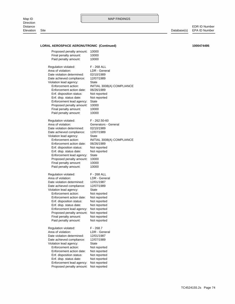
MAP FINDINGSMap IDDirection
EDR ID NumberDistanceEPA ID NumberDatabase(s)SiteElevation
Not reported Proposed penalty amount: Not reported Enforcement lead agency: Not reported Enf. disp. status date: Not reported Enf. disposition status: Not reported Enforcement action date: Not reported Enforcement action: StateViolation lead agency: 12/07/1989Date achieved compliance: 12/01/1987Date violation determined: LDR - GeneralArea of violation: F - 268.7Regulation violated:
Not reported Paid penalty amount: Not reported Final penalty amount: Not reported Proposed penalty amount: Not reported Enforcement lead agency: Not reported Enf. disp. status date: Not reported Enf. disposition status: Not reported Enforcement action date: Not reported Enforcement action: StateViolation lead agency: 12/07/1989Date achieved compliance: 12/01/1987Date violation determined: LDR - GeneralArea of violation: F - 268 ALLRegulation violated:
10000 Paid penalty amount: 10000 Final penalty amount: 10000 Proposed penalty amount: State Enforcement lead agency: Not reported Enf. disp. status date: Not reported Enf. disposition status: 06/26/1989 Enforcement action date: INITIAL 3008(A) COMPLIANCE Enforcement action: StateViolation lead agency: 12/07/1989Date achieved compliance: 02/10/1989Date violation determined: Generators - GeneralArea of violation: F - 262.50-60Regulation violated:
10000 Paid penalty amount: 10000 Final penalty amount: 10000 Proposed penalty amount: State Enforcement lead agency: Not reported Enf. disp. status date: Not reported Enf. disposition status: 06/26/1989 Enforcement action date: INITIAL 3008(A) COMPLIANCE Enforcement action: StateViolation lead agency: 12/07/1989Date achieved compliance: 02/10/1989Date violation determined: LDR - GeneralArea of violation: F - 268 ALLRegulation violated:
10000 Paid penalty amount: 10000 Final penalty amount: 10000 Proposed penalty amount:
LORAL AEROSPACE AERONUTRONIC (Continued) 1000474495
TC4524155.2s Page 74

MAP FINDINGSMap IDDirection
EDR ID NumberDistanceEPA ID NumberDatabase(s)SiteElevation
Not reported Final penalty amount: Not reported Proposed penalty amount: State Enforcement lead agency: Not reported Enf. disp. status date: Not reported Enf. disposition status: 11/23/1987 Enforcement action date: WRITTEN INFORMAL Enforcement action: StateViolation lead agency: 11/24/1987Date achieved compliance: 10/07/1987Date violation determined: Generators - GeneralArea of violation: FR - 262.50-60Regulation violated:
Not reported Paid penalty amount: Not reported Final penalty amount: Not reported Proposed penalty amount: State Enforcement lead agency: Not reported Enf. disp. status date: Not reported Enf. disposition status: 10/07/1987 Enforcement action date: WRITTEN INFORMAL Enforcement action: StateViolation lead agency: 11/24/1987Date achieved compliance: 10/07/1987Date violation determined: Generators - GeneralArea of violation: FR - 262.50-60Regulation violated:
Not reported Paid penalty amount: Not reported Final penalty amount: Not reported Proposed penalty amount: State Enforcement lead agency: Not reported Enf. disp. status date: Not reported Enf. disposition status: 11/23/1987 Enforcement action date: WRITTEN INFORMAL Enforcement action: StateViolation lead agency: 11/24/1987Date achieved compliance: 10/07/1987Date violation determined: Generators - GeneralArea of violation: FR - 262.20-23.BRegulation violated:
Not reported Paid penalty amount: Not reported Final penalty amount: Not reported Proposed penalty amount: State Enforcement lead agency: Not reported Enf. disp. status date: Not reported Enf. disposition status: 10/07/1987 Enforcement action date: WRITTEN INFORMAL Enforcement action: StateViolation lead agency: 11/24/1987Date achieved compliance: 10/07/1987Date violation determined: Generators - GeneralArea of violation: FR - 262.20-23.BRegulation violated:
Not reported Paid penalty amount: Not reported Final penalty amount:
LORAL AEROSPACE AERONUTRONIC (Continued) 1000474495
TC4524155.2s Page 75

MAP FINDINGSMap IDDirection
EDR ID NumberDistanceEPA ID NumberDatabase(s)SiteElevation
EPAEvaluation lead agency: 02/19/1992Date achieved compliance: Generators - GeneralArea of violation: COMPLIANCE EVALUATION INSPECTION ON-SITEEvaluation: 09/26/1991Evaluation date:
EPAEvaluation lead agency: 02/19/1992Date achieved compliance: LDR - GeneralArea of violation: COMPLIANCE EVALUATION INSPECTION ON-SITEEvaluation: 09/26/1991Evaluation date:
EPAEvaluation lead agency: 01/17/1992Date achieved compliance: Generators - GeneralArea of violation: COMPLIANCE EVALUATION INSPECTION ON-SITEEvaluation: 09/26/1991Evaluation date:
EPAEvaluation lead agency: 01/17/1992Date achieved compliance: LDR - GeneralArea of violation: COMPLIANCE EVALUATION INSPECTION ON-SITEEvaluation: 09/26/1991Evaluation date:
StateEvaluation lead agency: 07/21/1992Date achieved compliance: LDR - GeneralArea of violation: COMPLIANCE EVALUATION INSPECTION ON-SITEEvaluation: 02/19/1992Evaluation date:
StateEvaluation lead agency: 07/21/1992Date achieved compliance: TSD - GeneralArea of violation: COMPLIANCE EVALUATION INSPECTION ON-SITEEvaluation: 02/19/1992Evaluation date:
StateEvaluation lead agency: 03/28/1994Date achieved compliance: LDR - GeneralArea of violation: COMPLIANCE EVALUATION INSPECTION ON-SITEEvaluation: 04/21/1993Evaluation date:
StateEvaluation lead agency: 03/28/1994Date achieved compliance: Generators - GeneralArea of violation: COMPLIANCE EVALUATION INSPECTION ON-SITEEvaluation: 04/21/1993Evaluation date:
StateEvaluation lead agency: Not reportedDate achieved compliance: Not reportedArea of violation: FINANCIAL RECORD REVIEWEvaluation: 04/26/1993Evaluation date:
Evaluation Action Summary:
Not reported Paid penalty amount:
LORAL AEROSPACE AERONUTRONIC (Continued) 1000474495
TC4524155.2s Page 76

MAP FINDINGSMap IDDirection
EDR ID NumberDistanceEPA ID NumberDatabase(s)SiteElevation
NEWPORT BEACH, CA 92658-8900 1000 FORD RDFacility Address: FORD AEROSPC CORP AERONUTRONICFacility name: CAD041330077EPAID:
PADS:
Not reportedAction: 9Region: CAD041330077EPA ID:
2020 COR ACTION:
8/5/2008Effective date: 500000Face value: 500000Cost estimate: LOC ***0492Mechanism ID: LETTER OF CREDITMechanism type: ORANGECounty: 9EPA region: DEUTSCHE BANKProvider: CAD041330077EPA ID:
US FIN ASSUR:
StateEvaluation lead agency: 11/24/1987Date achieved compliance: Generators - GeneralArea of violation: COMPLIANCE EVALUATION INSPECTION ON-SITEEvaluation: 10/07/1987Evaluation date:
StateEvaluation lead agency: Not reportedDate achieved compliance: Not reportedArea of violation: FINANCIAL RECORD REVIEWEvaluation: 11/30/1987Evaluation date:
StateEvaluation lead agency: 12/07/1989Date achieved compliance: LDR - GeneralArea of violation: COMPLIANCE EVALUATION INSPECTION ON-SITEEvaluation: 12/01/1987Evaluation date:
StateEvaluation lead agency: Not reportedDate achieved compliance: Not reportedArea of violation: FINANCIAL RECORD REVIEWEvaluation: 02/08/1989Evaluation date:
StateEvaluation lead agency: 12/07/1989Date achieved compliance: LDR - GeneralArea of violation: COMPLIANCE EVALUATION INSPECTION ON-SITEEvaluation: 02/10/1989Evaluation date:
StateEvaluation lead agency: 12/07/1989Date achieved compliance: Generators - GeneralArea of violation: COMPLIANCE EVALUATION INSPECTION ON-SITEEvaluation: 02/10/1989Evaluation date:
LORAL AEROSPACE AERONUTRONIC (Continued) 1000474495
TC4524155.2s Page 77

MAP FINDINGSMap IDDirection
EDR ID NumberDistanceEPA ID NumberDatabase(s)SiteElevation
P - PoundsUnits: 00195Quantity: D003 - NON-LISTED REACTIVE WASTESWaste Code: NYD000632372TSDF ID: Not reportedTrans2 EPA ID: NYD980769947Trans1 EPA ID: CAD041330077Generator EPA ID: 04/18/1988Part B Recv Date: 05/17/1988Part A Recv Date: 04/08/1988TSD Site Recv Date: / /Trans2 Recv Date: 03/28/1988Trans1 Recv Date: 03/28/1988Generator Ship Date: Not reportedTrans2 State ID: 74492B-NYTrans1 State ID: Completed after the designated time period for a TSDF to get a copy to the DECManifest Status: NYA6107868Document ID:
Manifest:
714-720-6280Phone: USACountry: NEWPORTBEACH, CA 92660City/State/Zip: FORD ROADAddress: FORD AEROPSACE & COMMUNICATION CORPContact: FORD AEROPSACE & COMMUNICATION CORPName:
Mailing Info:
Not reportedLocation Zip Code 4: 92660Location Zip Code: CALocation State: NEWPORT BEACHLocation City: Not reportedLocation Address 2: FORD ROADLocation Address 1: USACountry: CAD041330077EPA ID:
NY MANIFEST:
05/17/1990Date received: 04/04/1990Cert. date: Not reportedCert. name: Not reportedCert. title: USMailing country: NEWPORT BEACH, CA 92658-8900 1000 FORD RDMailing address: Not reportedContact extension: (714)720-5887Contact tel: SWENINGSEN W BContact name: Not reportedContact title: FORD AEROSPACE CORPFacility owner name: NoSmelter: NoResearch facility: NoDisposer: NoTransporter: NoStorer: YesGenerator: USFacility country:
LORAL AEROSPACE AERONUTRONIC (Continued) 1000474495
TC4524155.2s Page 78

MAP FINDINGSMap IDDirection
EDR ID NumberDistanceEPA ID NumberDatabase(s)SiteElevation
1987Year: 100Specific Gravity: B Incineration, heat recovery, burning.Handling Method: CW - Wooden boxesContainer Type: 005Number of Containers: P - PoundsUnits: 00500Quantity: D001 - NON-LISTED IGNITABLE WASTESWaste Code: 100Specific Gravity: B Incineration, heat recovery, burning.Handling Method: DM - Metal drums, barrelsContainer Type: 002Number of Containers: P - PoundsUnits: 00500Quantity: D001 - NON-LISTED IGNITABLE WASTESWaste Code: 100Specific Gravity: B Incineration, heat recovery, burning.Handling Method: DM - Metal drums, barrelsContainer Type: 001Number of Containers: P - PoundsUnits: 00250Quantity: D001 - NON-LISTED IGNITABLE WASTESWaste Code: 100Specific Gravity: T Chemical, physical, or biological treatment.Handling Method: DM - Metal drums, barrelsContainer Type: 014Number of Containers: P - PoundsUnits: 03500Quantity: D001 - NON-LISTED IGNITABLE WASTESWaste Code: NYD000632372TSDF ID: Not reportedTrans2 EPA ID: CAD981465503Trans1 EPA ID: CAD041330077Generator EPA ID: 05/15/1987Part B Recv Date: 05/07/1987Part A Recv Date: 05/11/1987TSD Site Recv Date: / /Trans2 Recv Date: 04/28/1987Trans1 Recv Date: 04/28/1987Generator Ship Date: Not reportedTrans2 State ID: 703837Trans1 State ID: Completed copyManifest Status: NYA5440932Document ID:
1988Year: 100Specific Gravity: T Chemical, physical, or biological treatment.Handling Method: DM - Metal drums, barrelsContainer Type: 002Number of Containers:
LORAL AEROSPACE AERONUTRONIC (Continued) 1000474495
TC4524155.2s Page 79

MAP FINDINGSMap IDDirection
EDR ID NumberDistanceEPA ID NumberDatabase(s)SiteElevation
Not reportedComments: 01/01/1994Completed Date: Interim Measures WorkplanCompleted Document Type: Not reportedCompleted Sub Area Name: PROJECT WIDECompleted Area Name:
Not reportedComments: 03/09/2001Completed Date: Human Exposure ControlledCompleted Document Type: Not reportedCompleted Sub Area Name: PROJECT WIDECompleted Area Name:
Not reportedComments: 01/25/1991Completed Date: RCRA Facility Assessment ReportCompleted Document Type: Not reportedCompleted Sub Area Name: PROJECT WIDECompleted Area Name:
Completed Info:
Envirostor ID NumberAlias Type: 80001367Alias Name: Envirostor ID NumberAlias Type: 30370015Alias Name: EPA Identification NumberAlias Type: CAD041330077Alias Name: Alternate NameAlias Type: FORD AEROSPACE & COMMUNICATIONSAlias Name: NONE SPECIFIEDPotential Description: NONE SPECIFIEDConfirmed COC: NONE SPECIFIEDPotential COC: NONE SPECIFIEDPast Use: NONE SPECIFIEDAPN: -117.8698Longitude: 33.62970Latitude: Not reportedFunding: NONE SPECIFIEDSite Mgmt Req: NORestricted Use: Not reportedSpecial Program: 37Senate: 74Assembly: Cleanup CypressDivision Branch: * UnknownSupervisor: Not reportedProgram Manager: WQCLead Agency: RWQCBRegulatory Agencies: NONPL: 0Acres: Corrective ActionSite Type Detailed: Corrective ActionSite Type: Not reportedSite Code: 01/01/2008Status Date: Refer: RWQCBStatus: 80001367Facility ID:
ENVIROSTOR:
2927 ft. Site 2 of 2 in cluster E0.554 mi. CA HWP
Relative:Higher
Actual:212 ft.
1/2-1 CA EMINEWPORT BEACH, CA 92660NE CA SLIC1000 FORD ROAD N/AE27 CA ENVIROSTORFORD AEROSPACE & COMMUNICATIONS S100619625
TC4524155.2s Page 80

MAP FINDINGSMap IDDirection
EDR ID NumberDistanceEPA ID NumberDatabase(s)SiteElevation
2017Future Due Date: Groundwater Migration ControlledFuture Document Type: Not reportedFuture Sub Area Name: PROJECT WIDEFuture Area Name: 2017Future Due Date: Remedy ConstructedFuture Document Type: Not reportedFuture Sub Area Name: PROJECT WIDEFuture Area Name:
Not reportedComments: 10/14/1994Completed Date: Interim Measures QuestionnaireCompleted Document Type: Not reportedCompleted Sub Area Name: PROJECT WIDECompleted Area Name:
Not reportedComments: 01/01/1990Completed Date: Consent OrderCompleted Document Type: Not reportedCompleted Sub Area Name: PROJECT WIDECompleted Area Name:
Not reportedComments: 03/09/2001Completed Date: Groundwater Migration ControlledCompleted Document Type: Not reportedCompleted Sub Area Name: PROJECT WIDECompleted Area Name:
RSARACINO 19971203.17:02E RFI APPROVAL IS FOR SOILS ONLY. GW INVESTIGATION STILL UNDERWAY.Comments: 04/01/1995Completed Date: RFI ReportCompleted Document Type: Not reportedCompleted Sub Area Name: PROJECT WIDECompleted Area Name:
Not reportedComments: 12/01/1996Completed Date: Interim Measures Implementation ReportCompleted Document Type: Not reportedCompleted Sub Area Name: PROJECT WIDECompleted Area Name:
Not reportedComments: 02/17/1992Completed Date: RFI WorkplanCompleted Document Type: Not reportedCompleted Sub Area Name: PROJECT WIDECompleted Area Name:
Not reportedComments: 02/01/1996Completed Date: Interim Measures WorkplanCompleted Document Type: Not reportedCompleted Sub Area Name: PROJECT WIDECompleted Area Name:
Not reportedComments: 01/25/1991Completed Date: Preliminary Assessment ReportCompleted Document Type: Not reportedCompleted Sub Area Name: PROJECT WIDECompleted Area Name:
FORD AEROSPACE & COMMUNICATIONS (Continued) S100619625
TC4524155.2s Page 81
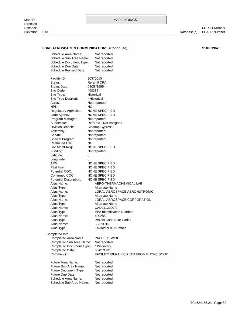
MAP FINDINGSMap IDDirection
EDR ID NumberDistanceEPA ID NumberDatabase(s)SiteElevation
Not reportedSchedule Sub Area Name: Not reportedSchedule Area Name: Not reportedFuture Due Date: Not reportedFuture Document Type: Not reportedFuture Sub Area Name: Not reportedFuture Area Name:
FACILITY IDENTIFIED ID’D FROM PHONE BOOKComments: 08/01/1981Completed Date: * DiscoveryCompleted Document Type: Not reportedCompleted Sub Area Name: PROJECT WIDECompleted Area Name:
Completed Info:
Envirostor ID NumberAlias Type: 30370015Alias Name: Project Code (Site Code)Alias Type: 400286Alias Name: EPA Identification NumberAlias Type: CAD041330077Alias Name: Alternate NameAlias Type: LORAL AEROSPACE CORPORATIONAlias Name: Alternate NameAlias Type: LORAL AEROSPACE AERONUTRONICAlias Name: Alternate NameAlias Type: AERO-THERMACHEMICAL LABAlias Name: NONE SPECIFIEDPotential Description: NONE SPECIFIEDConfirmed COC: NONE SPECIFIEDPotential COC: NONE SPECIFIEDPast Use: NONE SPECIFIEDAPN: 0Longitude: 0Latitude: Not reportedFunding: NONE SPECIFIEDSite Mgmt Req: NORestricted Use: Not reportedSpecial Program: Not reportedSenate: Not reportedAssembly: Cleanup CypressDivision Branch: Referred - Not AssignedSupervisor: Not reportedProgram Manager: NONE SPECIFIEDLead Agency: NONE SPECIFIEDRegulatory Agencies: NONPL: Not reportedAcres: * HistoricalSite Type Detailed: HistoricalSite Type: 400286Site Code: 08/28/1995Status Date: Refer: RCRAStatus: 30370015Facility ID:
Not reportedSchedule Revised Date: Not reportedSchedule Due Date: Not reportedSchedule Document Type: Not reportedSchedule Sub Area Name: Not reportedSchedule Area Name:
FORD AEROSPACE & COMMUNICATIONS (Continued) S100619625
TC4524155.2s Page 82
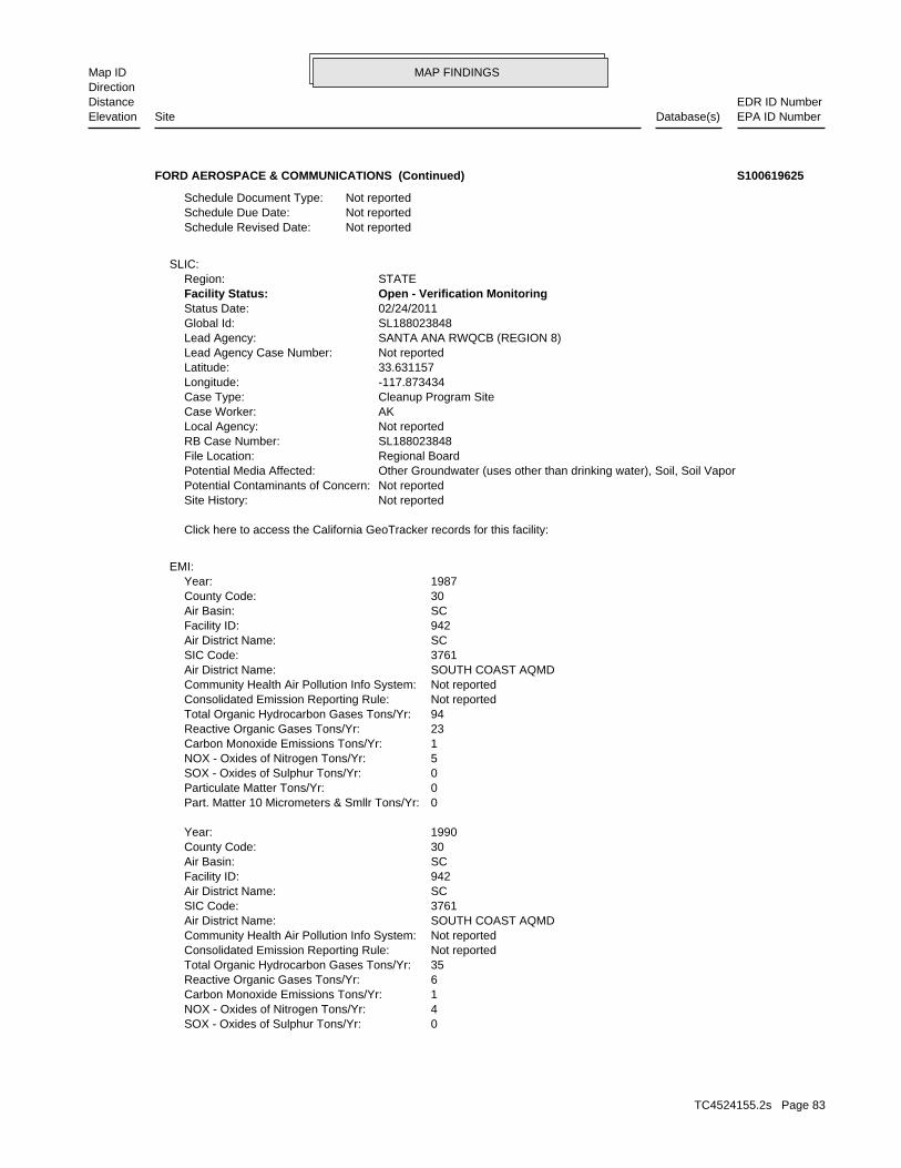
MAP FINDINGSMap IDDirection
EDR ID NumberDistanceEPA ID NumberDatabase(s)SiteElevation
0SOX - Oxides of Sulphur Tons/Yr: 4NOX - Oxides of Nitrogen Tons/Yr: 1Carbon Monoxide Emissions Tons/Yr: 6Reactive Organic Gases Tons/Yr: 35Total Organic Hydrocarbon Gases Tons/Yr: Not reportedConsolidated Emission Reporting Rule: Not reportedCommunity Health Air Pollution Info System: SOUTH COAST AQMDAir District Name: 3761SIC Code: SCAir District Name: 942Facility ID: SCAir Basin: 30County Code: 1990Year:
0Part. Matter 10 Micrometers & Smllr Tons/Yr: 0Particulate Matter Tons/Yr: 0SOX - Oxides of Sulphur Tons/Yr: 5NOX - Oxides of Nitrogen Tons/Yr: 1Carbon Monoxide Emissions Tons/Yr: 23Reactive Organic Gases Tons/Yr: 94Total Organic Hydrocarbon Gases Tons/Yr: Not reportedConsolidated Emission Reporting Rule: Not reportedCommunity Health Air Pollution Info System: SOUTH COAST AQMDAir District Name: 3761SIC Code: SCAir District Name: 942Facility ID: SCAir Basin: 30County Code: 1987Year:
EMI:
Click here to access the California GeoTracker records for this facility:
Not reportedSite History: Not reportedPotential Contaminants of Concern: Other Groundwater (uses other than drinking water), Soil, Soil VaporPotential Media Affected: Regional BoardFile Location: SL188023848RB Case Number: Not reportedLocal Agency: AKCase Worker: Cleanup Program SiteCase Type: -117.873434Longitude: 33.631157Latitude: Not reportedLead Agency Case Number: SANTA ANA RWQCB (REGION 8)Lead Agency: SL188023848Global Id: 02/24/2011Status Date: Open - Verification MonitoringFacility Status: STATERegion:
SLIC:
Not reportedSchedule Revised Date: Not reportedSchedule Due Date: Not reportedSchedule Document Type:
FORD AEROSPACE & COMMUNICATIONS (Continued) S100619625
TC4524155.2s Page 83
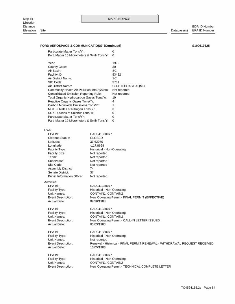
MAP FINDINGSMap IDDirection
EDR ID NumberDistanceEPA ID NumberDatabase(s)SiteElevation
New Operating Permit - TECHNICAL COMPLETE LETTEREvent Description: CONTAIN1, CONTAIN2Unit Names: Historical - Non-OperatingFacility Type: CAD041330077EPA Id:
10/05/1988Actual Date: Renewal - Historical - FINAL PERMIT RENEWAL - WITHDRAWAL REQUEST RECEIVEDEvent Description: Not reportedUnit Names: Historical - Non-OperatingFacility Type: CAD041330077EPA Id:
03/03/1983Actual Date: New Operating Permit - CALL-IN LETTER ISSUEDEvent Description: CONTAIN1, CONTAIN2Unit Names: Historical - Non-OperatingFacility Type: CAD041330077EPA Id:
09/30/1983Actual Date: New Operating Permit - FINAL PERMIT (EFFECTIVE)Event Description: CONTAIN1, CONTAIN2Unit Names: Historical - Non-OperatingFacility Type: CAD041330077EPA Id:
Activities:
Not reportedPublic Information Officer: 37Senate District: 74Assembly District: Not reportedSite Code: Not reportedSupervisor: Not reportedTeam: Not reportedFacility Size: Historical - Non-OperatingFacility Type: -117.8698Longitude: 33.62970Latitude: CLOSEDCleanup Status: CAD041330077EPA Id:
HWP:
0Part. Matter 10 Micrometers & Smllr Tons/Yr: 0Particulate Matter Tons/Yr: 0SOX - Oxides of Sulphur Tons/Yr: 3NOX - Oxides of Nitrogen Tons/Yr: 1Carbon Monoxide Emissions Tons/Yr: 4Reactive Organic Gases Tons/Yr: 19Total Organic Hydrocarbon Gases Tons/Yr: Not reportedConsolidated Emission Reporting Rule: Not reportedCommunity Health Air Pollution Info System: SOUTH COAST AQMDAir District Name: 3761SIC Code: SCAir District Name: 83482Facility ID: SCAir Basin: 30County Code: 1995Year:
0Part. Matter 10 Micrometers & Smllr Tons/Yr: 0Particulate Matter Tons/Yr:
FORD AEROSPACE & COMMUNICATIONS (Continued) S100619625
TC4524155.2s Page 84

MAP FINDINGSMap IDDirection
EDR ID NumberDistanceEPA ID NumberDatabase(s)SiteElevation
08/13/1993Actual Date: Closure Final - CLOSURE PLAN APPROVEDEvent Description: CONTAIN1, CONTAIN2Unit Names: Historical - Non-OperatingFacility Type: CAD041330077EPA Id:
02/01/1995Actual Date: Closure Final - ISSUE CLOSURE VERIFICATIONEvent Description: CONTAIN1, CONTAIN2Unit Names: Historical - Non-OperatingFacility Type: CAD041330077EPA Id:
Closure:
08/13/1992Actual Date: Renewal - Historical - FINAL PERMIT RENEWAL - WITHDRAWAL REQUEST ACKNOWLEDGEDEvent Description: Not reportedUnit Names: Historical - Non-OperatingFacility Type: CAD041330077EPA Id:
09/30/1988Actual Date: New Operating Permit - FINAL PERMIT (EXPIRES)Event Description: CONTAIN1, CONTAIN2Unit Names: Historical - Non-OperatingFacility Type: CAD041330077EPA Id:
07/25/1983Actual Date: New Operating Permit - PUBLIC COMMENT (BEGIN)Event Description: CONTAIN1, CONTAIN2Unit Names: Historical - Non-OperatingFacility Type: CAD041330077EPA Id:
04/22/1983Actual Date: New Operating Permit - APPLICATION PART B RECEIVEDEvent Description: CONTAIN1, CONTAIN2Unit Names: Historical - Non-OperatingFacility Type: CAD041330077EPA Id:
11/19/1980Actual Date: New Operating Permit - APPLICATION PART A RECEIVEDEvent Description: CONTAIN1, CONTAIN2Unit Names: Historical - Non-OperatingFacility Type: CAD041330077EPA Id:
09/22/1988Actual Date: Renewal - Historical - CALL-IN LETTER ISSUEDEvent Description: Not reportedUnit Names: Historical - Non-OperatingFacility Type: CAD041330077EPA Id:
09/30/1983Actual Date: New Operating Permit - FINAL PERMITEvent Description: CONTAIN1, CONTAIN2Unit Names: Historical - Non-OperatingFacility Type: CAD041330077EPA Id:
08/30/1983Actual Date:
FORD AEROSPACE & COMMUNICATIONS (Continued) S100619625
TC4524155.2s Page 85

MAP FINDINGSMap IDDirection
EDR ID NumberDistanceEPA ID NumberDatabase(s)SiteElevation
30370015Alias: Envirostor ID NumberAlias Type: Historical - Non-OperatingFacility Type: CAD041330077EPA Id:
FORD AEROSPACE & COMMUNICATIONSAlias: Alternate NameAlias Type: Historical - Non-OperatingFacility Type: CAD041330077EPA Id:
Alias:
08/13/1993Actual Date: Closure Final - CLOSURE PLAN REQUESTEDEvent Description: CONTAIN1, CONTAIN2Unit Names: Historical - Non-OperatingFacility Type: CAD041330077EPA Id:
FORD AEROSPACE & COMMUNICATIONS (Continued) S100619625
TC4524155.2s Page 86

ORPHAN SUMMARY
City EDR ID Site Name Site Address Zip Database(s)
Count: 0 records.
NO SITES FOUND
TC4524155.2s Page 87
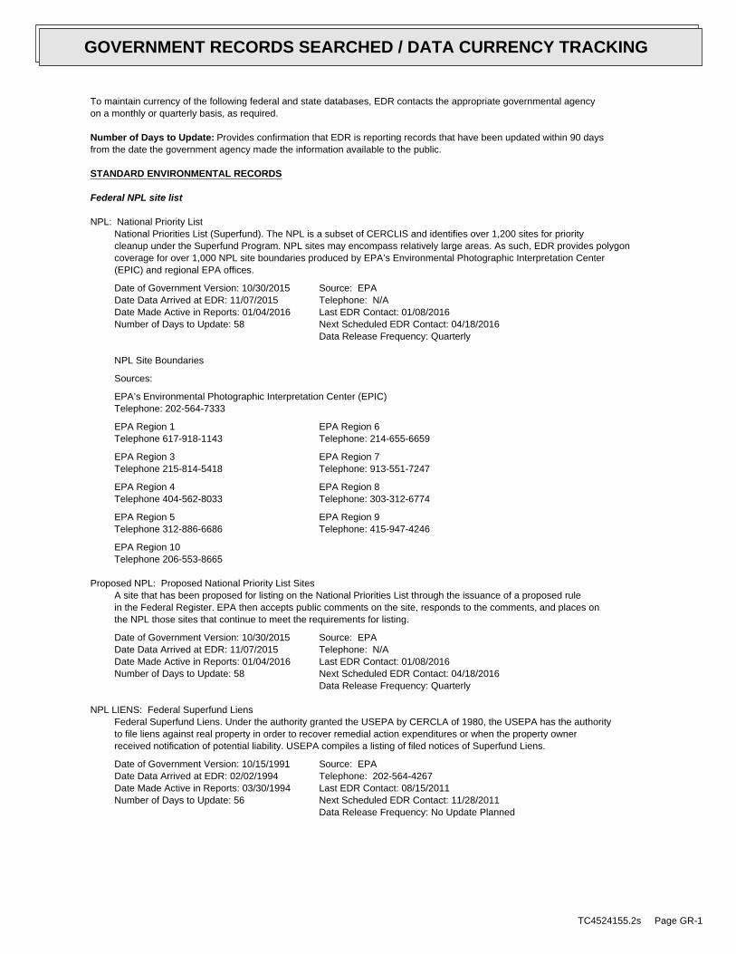
To maintain currency of the following federal and state databases, EDR contacts the appropriate governmental agencyon a monthly or quarterly basis, as required.
Number of Days to Update: Provides confirmation that EDR is reporting records that have been updated within 90 daysfrom the date the government agency made the information available to the public.
STANDARD ENVIRONMENTAL RECORDS
Federal NPL site list
NPL: National Priority ListNational Priorities List (Superfund). The NPL is a subset of CERCLIS and identifies over 1,200 sites for prioritycleanup under the Superfund Program. NPL sites may encompass relatively large areas. As such, EDR provides polygoncoverage for over 1,000 NPL site boundaries produced by EPA’s Environmental Photographic Interpretation Center(EPIC) and regional EPA offices.
Date of Government Version: 10/30/2015Date Data Arrived at EDR: 11/07/2015Date Made Active in Reports: 01/04/2016Number of Days to Update: 58
Source: EPATelephone: N/ALast EDR Contact: 01/08/2016Next Scheduled EDR Contact: 04/18/2016Data Release Frequency: Quarterly
NPL Site Boundaries
Sources:
EPA’s Environmental Photographic Interpretation Center (EPIC)Telephone: 202-564-7333
EPA Region 1 EPA Region 6Telephone 617-918-1143 Telephone: 214-655-6659
EPA Region 3 EPA Region 7Telephone 215-814-5418 Telephone: 913-551-7247
EPA Region 4 EPA Region 8Telephone 404-562-8033 Telephone: 303-312-6774
EPA Region 5 EPA Region 9Telephone 312-886-6686 Telephone: 415-947-4246
EPA Region 10Telephone 206-553-8665
Proposed NPL: Proposed National Priority List SitesA site that has been proposed for listing on the National Priorities List through the issuance of a proposed rulein the Federal Register. EPA then accepts public comments on the site, responds to the comments, and places onthe NPL those sites that continue to meet the requirements for listing.
Date of Government Version: 10/30/2015Date Data Arrived at EDR: 11/07/2015Date Made Active in Reports: 01/04/2016Number of Days to Update: 58
Source: EPATelephone: N/ALast EDR Contact: 01/08/2016Next Scheduled EDR Contact: 04/18/2016Data Release Frequency: Quarterly
NPL LIENS: Federal Superfund LiensFederal Superfund Liens. Under the authority granted the USEPA by CERCLA of 1980, the USEPA has the authorityto file liens against real property in order to recover remedial action expenditures or when the property ownerreceived notification of potential liability. USEPA compiles a listing of filed notices of Superfund Liens.
Date of Government Version: 10/15/1991Date Data Arrived at EDR: 02/02/1994Date Made Active in Reports: 03/30/1994Number of Days to Update: 56
Source: EPATelephone: 202-564-4267Last EDR Contact: 08/15/2011Next Scheduled EDR Contact: 11/28/2011Data Release Frequency: No Update Planned
TC4524155.2s Page GR-1
GOVERNMENT RECORDS SEARCHED / DATA CURRENCY TRACKING

Federal Delisted NPL site list
Delisted NPL: National Priority List DeletionsThe National Oil and Hazardous Substances Pollution Contingency Plan (NCP) establishes the criteria that theEPA uses to delete sites from the NPL. In accordance with 40 CFR 300.425.(e), sites may be deleted from theNPL where no further response is appropriate.
Date of Government Version: 10/30/2015Date Data Arrived at EDR: 11/07/2015Date Made Active in Reports: 01/04/2016Number of Days to Update: 58
Source: EPATelephone: N/ALast EDR Contact: 01/08/2016Next Scheduled EDR Contact: 04/18/2016Data Release Frequency: Quarterly
Federal CERCLIS list
FEDERAL FACILITY: Federal Facility Site Information listingA listing of National Priority List (NPL) and Base Realignment and Closure (BRAC) sites found in the ComprehensiveEnvironmental Response, Compensation and Liability Information System (CERCLIS) Database where EPA Federal FacilitiesRestoration and Reuse Office is involved in cleanup activities.
Date of Government Version: 03/26/2015Date Data Arrived at EDR: 04/08/2015Date Made Active in Reports: 06/11/2015Number of Days to Update: 64
Source: Environmental Protection AgencyTelephone: 703-603-8704Last EDR Contact: 01/06/2016Next Scheduled EDR Contact: 04/18/2016Data Release Frequency: Varies
CERCLIS: Comprehensive Environmental Response, Compensation, and Liability Information SystemCERCLIS contains data on potentially hazardous waste sites that have been reported to the USEPA by states, municipalities,private companies and private persons, pursuant to Section 103 of the Comprehensive Environmental Response, Compensation,and Liability Act (CERCLA). CERCLIS contains sites which are either proposed to or on the National PrioritiesList (NPL) and sites which are in the screening and assessment phase for possible inclusion on the NPL.
Date of Government Version: 10/25/2013Date Data Arrived at EDR: 11/11/2013Date Made Active in Reports: 02/13/2014Number of Days to Update: 94
Source: EPATelephone: 703-412-9810Last EDR Contact: 11/23/2015Next Scheduled EDR Contact: 03/07/2016Data Release Frequency: Quarterly
Federal CERCLIS NFRAP site List
CERCLIS-NFRAP: CERCLIS No Further Remedial Action PlannedArchived sites are sites that have been removed and archived from the inventory of CERCLIS sites. Archived statusindicates that, to the best of EPA’s knowledge, assessment at a site has been completed and that EPA has determinedno further steps will be taken to list this site on the National Priorities List (NPL), unless information indicatesthis decision was not appropriate or other considerations require a recommendation for listing at a later time.This decision does not necessarily mean that there is no hazard associated with a given site; it only means that,based upon available information, the location is not judged to be a potential NPL site.
Date of Government Version: 10/25/2013Date Data Arrived at EDR: 11/11/2013Date Made Active in Reports: 02/13/2014Number of Days to Update: 94
Source: EPATelephone: 703-412-9810Last EDR Contact: 11/23/2015Next Scheduled EDR Contact: 03/07/2016Data Release Frequency: Quarterly
Federal RCRA CORRACTS facilities list
CORRACTS: Corrective Action ReportCORRACTS identifies hazardous waste handlers with RCRA corrective action activity.
TC4524155.2s Page GR-2
GOVERNMENT RECORDS SEARCHED / DATA CURRENCY TRACKING

Date of Government Version: 06/09/2015Date Data Arrived at EDR: 06/26/2015Date Made Active in Reports: 09/16/2015Number of Days to Update: 82
Source: EPATelephone: 800-424-9346Last EDR Contact: 12/18/2015Next Scheduled EDR Contact: 04/11/2016Data Release Frequency: Quarterly
Federal RCRA non-CORRACTS TSD facilities list
RCRA-TSDF: RCRA - Treatment, Storage and DisposalRCRAInfo is EPA’s comprehensive information system, providing access to data supporting the Resource Conservationand Recovery Act (RCRA) of 1976 and the Hazardous and Solid Waste Amendments (HSWA) of 1984. The databaseincludes selective information on sites which generate, transport, store, treat and/or dispose of hazardous wasteas defined by the Resource Conservation and Recovery Act (RCRA). Transporters are individuals or entities thatmove hazardous waste from the generator offsite to a facility that can recycle, treat, store, or dispose of thewaste. TSDFs treat, store, or dispose of the waste.
Date of Government Version: 06/09/2015Date Data Arrived at EDR: 06/26/2015Date Made Active in Reports: 09/16/2015Number of Days to Update: 82
Source: Environmental Protection AgencyTelephone: (415) 495-8895Last EDR Contact: 12/18/2015Next Scheduled EDR Contact: 04/11/2016Data Release Frequency: Quarterly
Federal RCRA generators list
RCRA-LQG: RCRA - Large Quantity GeneratorsRCRAInfo is EPA’s comprehensive information system, providing access to data supporting the Resource Conservationand Recovery Act (RCRA) of 1976 and the Hazardous and Solid Waste Amendments (HSWA) of 1984. The databaseincludes selective information on sites which generate, transport, store, treat and/or dispose of hazardous wasteas defined by the Resource Conservation and Recovery Act (RCRA). Large quantity generators (LQGs) generateover 1,000 kilograms (kg) of hazardous waste, or over 1 kg of acutely hazardous waste per month.
Date of Government Version: 06/09/2015Date Data Arrived at EDR: 06/26/2015Date Made Active in Reports: 09/16/2015Number of Days to Update: 82
Source: Environmental Protection AgencyTelephone: (415) 495-8895Last EDR Contact: 12/18/2015Next Scheduled EDR Contact: 04/11/2016Data Release Frequency: Quarterly
RCRA-SQG: RCRA - Small Quantity GeneratorsRCRAInfo is EPA’s comprehensive information system, providing access to data supporting the Resource Conservationand Recovery Act (RCRA) of 1976 and the Hazardous and Solid Waste Amendments (HSWA) of 1984. The databaseincludes selective information on sites which generate, transport, store, treat and/or dispose of hazardous wasteas defined by the Resource Conservation and Recovery Act (RCRA). Small quantity generators (SQGs) generatebetween 100 kg and 1,000 kg of hazardous waste per month.
Date of Government Version: 06/09/2015Date Data Arrived at EDR: 06/26/2015Date Made Active in Reports: 09/16/2015Number of Days to Update: 82
Source: Environmental Protection AgencyTelephone: (415) 495-8895Last EDR Contact: 12/18/2015Next Scheduled EDR Contact: 04/11/2016Data Release Frequency: Quarterly
RCRA-CESQG: RCRA - Conditionally Exempt Small Quantity GeneratorsRCRAInfo is EPA’s comprehensive information system, providing access to data supporting the Resource Conservationand Recovery Act (RCRA) of 1976 and the Hazardous and Solid Waste Amendments (HSWA) of 1984. The databaseincludes selective information on sites which generate, transport, store, treat and/or dispose of hazardous wasteas defined by the Resource Conservation and Recovery Act (RCRA). Conditionally exempt small quantity generators(CESQGs) generate less than 100 kg of hazardous waste, or less than 1 kg of acutely hazardous waste per month.
Date of Government Version: 06/09/2015Date Data Arrived at EDR: 06/26/2015Date Made Active in Reports: 09/16/2015Number of Days to Update: 82
Source: Environmental Protection AgencyTelephone: (415) 495-8895Last EDR Contact: 12/18/2015Next Scheduled EDR Contact: 04/11/2016Data Release Frequency: Varies
TC4524155.2s Page GR-3
GOVERNMENT RECORDS SEARCHED / DATA CURRENCY TRACKING

Federal institutional controls / engineering controls registries
LUCIS: Land Use Control Information SystemLUCIS contains records of land use control information pertaining to the former Navy Base Realignment and Closureproperties.
Date of Government Version: 05/28/2015Date Data Arrived at EDR: 05/29/2015Date Made Active in Reports: 06/11/2015Number of Days to Update: 13
Source: Department of the NavyTelephone: 843-820-7326Last EDR Contact: 11/13/2015Next Scheduled EDR Contact: 02/29/2016Data Release Frequency: Varies
US ENG CONTROLS: Engineering Controls Sites ListA listing of sites with engineering controls in place. Engineering controls include various forms of caps, buildingfoundations, liners, and treatment methods to create pathway elimination for regulated substances to enter environmentalmedia or effect human health.
Date of Government Version: 09/10/2015Date Data Arrived at EDR: 09/11/2015Date Made Active in Reports: 11/03/2015Number of Days to Update: 53
Source: Environmental Protection AgencyTelephone: 703-603-0695Last EDR Contact: 11/24/2015Next Scheduled EDR Contact: 03/14/2016Data Release Frequency: Varies
US INST CONTROL: Sites with Institutional ControlsA listing of sites with institutional controls in place. Institutional controls include administrative measures,such as groundwater use restrictions, construction restrictions, property use restrictions, and post remediationcare requirements intended to prevent exposure to contaminants remaining on site. Deed restrictions are generallyrequired as part of the institutional controls.
Date of Government Version: 09/10/2015Date Data Arrived at EDR: 09/11/2015Date Made Active in Reports: 11/03/2015Number of Days to Update: 53
Source: Environmental Protection AgencyTelephone: 703-603-0695Last EDR Contact: 11/24/2015Next Scheduled EDR Contact: 03/14/2016Data Release Frequency: Varies
Federal ERNS list
ERNS: Emergency Response Notification SystemEmergency Response Notification System. ERNS records and stores information on reported releases of oil and hazardoussubstances.
Date of Government Version: 06/22/2015Date Data Arrived at EDR: 06/26/2015Date Made Active in Reports: 09/16/2015Number of Days to Update: 82
Source: National Response Center, United States Coast GuardTelephone: 202-267-2180Last EDR Contact: 12/29/2015Next Scheduled EDR Contact: 04/11/2016Data Release Frequency: Annually
State- and tribal - equivalent NPL
RESPONSE: State Response SitesIdentifies confirmed release sites where DTSC is involved in remediation, either in a lead or oversight capacity.These confirmed release sites are generally high-priority and high potential risk.
Date of Government Version: 11/07/2015Date Data Arrived at EDR: 11/07/2015Date Made Active in Reports: 12/17/2015Number of Days to Update: 40
Source: Department of Toxic Substances ControlTelephone: 916-323-3400Last EDR Contact: 11/07/2015Next Scheduled EDR Contact: 02/15/2016Data Release Frequency: Quarterly
State- and tribal - equivalent CERCLIS
TC4524155.2s Page GR-4
GOVERNMENT RECORDS SEARCHED / DATA CURRENCY TRACKING

ENVIROSTOR: EnviroStor DatabaseThe Department of Toxic Substances Control’s (DTSC’s) Site Mitigation and Brownfields Reuse Program’s (SMBRP’s)EnviroStor database identifes sites that have known contamination or sites for which there may be reasons to investigatefurther. The database includes the following site types: Federal Superfund sites (National Priorities List (NPL));State Response, including Military Facilities and State Superfund; Voluntary Cleanup; and School sites. EnviroStorprovides similar information to the information that was available in CalSites, and provides additional site information,including, but not limited to, identification of formerly-contaminated properties that have been released forreuse, properties where environmental deed restrictions have been recorded to prevent inappropriate land uses,and risk characterization information that is used to assess potential impacts to public health and the environmentat contaminated sites.
Date of Government Version: 11/07/2015Date Data Arrived at EDR: 11/07/2015Date Made Active in Reports: 12/17/2015Number of Days to Update: 40
Source: Department of Toxic Substances ControlTelephone: 916-323-3400Last EDR Contact: 11/07/2015Next Scheduled EDR Contact: 02/15/2016Data Release Frequency: Quarterly
State and tribal landfill and/or solid waste disposal site lists
SWF/LF (SWIS): Solid Waste Information SystemActive, Closed and Inactive Landfills. SWF/LF records typically contain an inve ntory of solid waste disposalfacilities or landfills. These may be active or i nactive facilities or open dumps that failed to meet RCRA Section4004 criteria for solid waste landfills or disposal sites.
Date of Government Version: 11/16/2015Date Data Arrived at EDR: 11/18/2015Date Made Active in Reports: 01/21/2016Number of Days to Update: 64
Source: Department of Resources Recycling and RecoveryTelephone: 916-341-6320Last EDR Contact: 11/18/2015Next Scheduled EDR Contact: 02/29/2016Data Release Frequency: Quarterly
State and tribal leaking storage tank lists
LUST REG 3: Leaking Underground Storage Tank DatabaseLeaking Underground Storage Tank locations. Monterey, San Benito, San Luis Obispo, Santa Barbara, Santa Cruz counties.
Date of Government Version: 05/19/2003Date Data Arrived at EDR: 05/19/2003Date Made Active in Reports: 06/02/2003Number of Days to Update: 14
Source: California Regional Water Quality Control Board Central Coast Region (3)Telephone: 805-542-4786Last EDR Contact: 07/18/2011Next Scheduled EDR Contact: 10/31/2011Data Release Frequency: No Update Planned
LUST REG 4: Underground Storage Tank Leak ListLos Angeles, Ventura counties. For more current information, please refer to the State Water Resources ControlBoard’s LUST database.
Date of Government Version: 09/07/2004Date Data Arrived at EDR: 09/07/2004Date Made Active in Reports: 10/12/2004Number of Days to Update: 35
Source: California Regional Water Quality Control Board Los Angeles Region (4)Telephone: 213-576-6710Last EDR Contact: 09/06/2011Next Scheduled EDR Contact: 12/19/2011Data Release Frequency: No Update Planned
LUST REG 6L: Leaking Underground Storage Tank Case ListingFor more current information, please refer to the State Water Resources Control Board’s LUST database.
Date of Government Version: 09/09/2003Date Data Arrived at EDR: 09/10/2003Date Made Active in Reports: 10/07/2003Number of Days to Update: 27
Source: California Regional Water Quality Control Board Lahontan Region (6)Telephone: 530-542-5572Last EDR Contact: 09/12/2011Next Scheduled EDR Contact: 12/26/2011Data Release Frequency: No Update Planned
TC4524155.2s Page GR-5
GOVERNMENT RECORDS SEARCHED / DATA CURRENCY TRACKING
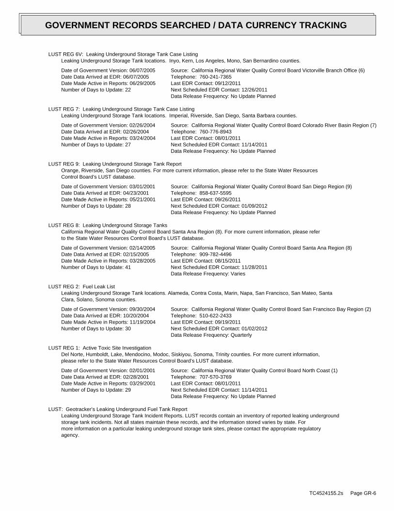
LUST REG 6V: Leaking Underground Storage Tank Case ListingLeaking Underground Storage Tank locations. Inyo, Kern, Los Angeles, Mono, San Bernardino counties.
Date of Government Version: 06/07/2005Date Data Arrived at EDR: 06/07/2005Date Made Active in Reports: 06/29/2005Number of Days to Update: 22
Source: California Regional Water Quality Control Board Victorville Branch Office (6)Telephone: 760-241-7365Last EDR Contact: 09/12/2011Next Scheduled EDR Contact: 12/26/2011Data Release Frequency: No Update Planned
LUST REG 7: Leaking Underground Storage Tank Case ListingLeaking Underground Storage Tank locations. Imperial, Riverside, San Diego, Santa Barbara counties.
Date of Government Version: 02/26/2004Date Data Arrived at EDR: 02/26/2004Date Made Active in Reports: 03/24/2004Number of Days to Update: 27
Source: California Regional Water Quality Control Board Colorado River Basin Region (7)Telephone: 760-776-8943Last EDR Contact: 08/01/2011Next Scheduled EDR Contact: 11/14/2011Data Release Frequency: No Update Planned
LUST REG 9: Leaking Underground Storage Tank ReportOrange, Riverside, San Diego counties. For more current information, please refer to the State Water ResourcesControl Board’s LUST database.
Date of Government Version: 03/01/2001Date Data Arrived at EDR: 04/23/2001Date Made Active in Reports: 05/21/2001Number of Days to Update: 28
Source: California Regional Water Quality Control Board San Diego Region (9)Telephone: 858-637-5595Last EDR Contact: 09/26/2011Next Scheduled EDR Contact: 01/09/2012Data Release Frequency: No Update Planned
LUST REG 8: Leaking Underground Storage TanksCalifornia Regional Water Quality Control Board Santa Ana Region (8). For more current information, please referto the State Water Resources Control Board’s LUST database.
Date of Government Version: 02/14/2005Date Data Arrived at EDR: 02/15/2005Date Made Active in Reports: 03/28/2005Number of Days to Update: 41
Source: California Regional Water Quality Control Board Santa Ana Region (8)Telephone: 909-782-4496Last EDR Contact: 08/15/2011Next Scheduled EDR Contact: 11/28/2011Data Release Frequency: Varies
LUST REG 2: Fuel Leak ListLeaking Underground Storage Tank locations. Alameda, Contra Costa, Marin, Napa, San Francisco, San Mateo, SantaClara, Solano, Sonoma counties.
Date of Government Version: 09/30/2004Date Data Arrived at EDR: 10/20/2004Date Made Active in Reports: 11/19/2004Number of Days to Update: 30
Source: California Regional Water Quality Control Board San Francisco Bay Region (2)Telephone: 510-622-2433Last EDR Contact: 09/19/2011Next Scheduled EDR Contact: 01/02/2012Data Release Frequency: Quarterly
LUST REG 1: Active Toxic Site InvestigationDel Norte, Humboldt, Lake, Mendocino, Modoc, Siskiyou, Sonoma, Trinity counties. For more current information,please refer to the State Water Resources Control Board’s LUST database.
Date of Government Version: 02/01/2001Date Data Arrived at EDR: 02/28/2001Date Made Active in Reports: 03/29/2001Number of Days to Update: 29
Source: California Regional Water Quality Control Board North Coast (1)Telephone: 707-570-3769Last EDR Contact: 08/01/2011Next Scheduled EDR Contact: 11/14/2011Data Release Frequency: No Update Planned
LUST: Geotracker’s Leaking Underground Fuel Tank ReportLeaking Underground Storage Tank Incident Reports. LUST records contain an inventory of reported leaking undergroundstorage tank incidents. Not all states maintain these records, and the information stored varies by state. Formore information on a particular leaking underground storage tank sites, please contact the appropriate regulatoryagency.
TC4524155.2s Page GR-6
GOVERNMENT RECORDS SEARCHED / DATA CURRENCY TRACKING

Date of Government Version: 10/21/2015Date Data Arrived at EDR: 10/22/2015Date Made Active in Reports: 11/05/2015Number of Days to Update: 14
Source: State Water Resources Control BoardTelephone: see region listLast EDR Contact: 12/14/2015Next Scheduled EDR Contact: 03/28/2016Data Release Frequency: Quarterly
LUST REG 5: Leaking Underground Storage Tank DatabaseLeaking Underground Storage Tank locations. Alameda, Alpine, Amador, Butte, Colusa, Contra Costa, Calveras, ElDorado, Fresno, Glenn, Kern, Kings, Lake, Lassen, Madera, Mariposa, Merced, Modoc, Napa, Nevada, Placer, Plumas,Sacramento, San Joaquin, Shasta, Solano, Stanislaus, Sutter, Tehama, Tulare, Tuolumne, Yolo, Yuba counties.
Date of Government Version: 07/01/2008Date Data Arrived at EDR: 07/22/2008Date Made Active in Reports: 07/31/2008Number of Days to Update: 9
Source: California Regional Water Quality Control Board Central Valley Region (5)Telephone: 916-464-4834Last EDR Contact: 07/01/2011Next Scheduled EDR Contact: 10/17/2011Data Release Frequency: No Update Planned
INDIAN LUST R5: Leaking Underground Storage Tanks on Indian LandLeaking underground storage tanks located on Indian Land in Michigan, Minnesota and Wisconsin.
Date of Government Version: 11/04/2015Date Data Arrived at EDR: 11/13/2015Date Made Active in Reports: 01/04/2016Number of Days to Update: 52
Source: EPA, Region 5Telephone: 312-886-7439Last EDR Contact: 10/26/2015Next Scheduled EDR Contact: 02/08/2016Data Release Frequency: Varies
INDIAN LUST R9: Leaking Underground Storage Tanks on Indian LandLUSTs on Indian land in Arizona, California, New Mexico and Nevada
Date of Government Version: 01/08/2015Date Data Arrived at EDR: 01/08/2015Date Made Active in Reports: 02/09/2015Number of Days to Update: 32
Source: Environmental Protection AgencyTelephone: 415-972-3372Last EDR Contact: 10/30/2015Next Scheduled EDR Contact: 02/08/2016Data Release Frequency: Quarterly
INDIAN LUST R10: Leaking Underground Storage Tanks on Indian LandLUSTs on Indian land in Alaska, Idaho, Oregon and Washington.
Date of Government Version: 07/21/2015Date Data Arrived at EDR: 07/29/2015Date Made Active in Reports: 10/13/2015Number of Days to Update: 76
Source: EPA Region 10Telephone: 206-553-2857Last EDR Contact: 01/07/2016Next Scheduled EDR Contact: 02/08/2016Data Release Frequency: Quarterly
INDIAN LUST R8: Leaking Underground Storage Tanks on Indian LandLUSTs on Indian land in Colorado, Montana, North Dakota, South Dakota, Utah and Wyoming.
Date of Government Version: 04/30/2015Date Data Arrived at EDR: 05/05/2015Date Made Active in Reports: 06/22/2015Number of Days to Update: 48
Source: EPA Region 8Telephone: 303-312-6271Last EDR Contact: 10/08/2015Next Scheduled EDR Contact: 02/08/2016Data Release Frequency: Quarterly
INDIAN LUST R7: Leaking Underground Storage Tanks on Indian LandLUSTs on Indian land in Iowa, Kansas, and Nebraska
Date of Government Version: 03/30/2015Date Data Arrived at EDR: 04/28/2015Date Made Active in Reports: 06/22/2015Number of Days to Update: 55
Source: EPA Region 7Telephone: 913-551-7003Last EDR Contact: 10/08/2015Next Scheduled EDR Contact: 02/08/2016Data Release Frequency: Varies
TC4524155.2s Page GR-7
GOVERNMENT RECORDS SEARCHED / DATA CURRENCY TRACKING

INDIAN LUST R6: Leaking Underground Storage Tanks on Indian LandLUSTs on Indian land in New Mexico and Oklahoma.
Date of Government Version: 05/13/2015Date Data Arrived at EDR: 08/03/2015Date Made Active in Reports: 10/13/2015Number of Days to Update: 71
Source: EPA Region 6Telephone: 214-665-6597Last EDR Contact: 10/26/2015Next Scheduled EDR Contact: 02/08/2016Data Release Frequency: Varies
INDIAN LUST R4: Leaking Underground Storage Tanks on Indian LandLUSTs on Indian land in Florida, Mississippi and North Carolina.
Date of Government Version: 11/24/2015Date Data Arrived at EDR: 12/01/2015Date Made Active in Reports: 01/04/2016Number of Days to Update: 34
Source: EPA Region 4Telephone: 404-562-8677Last EDR Contact: 10/26/2015Next Scheduled EDR Contact: 02/08/2016Data Release Frequency: Semi-Annually
INDIAN LUST R1: Leaking Underground Storage Tanks on Indian LandA listing of leaking underground storage tank locations on Indian Land.
Date of Government Version: 10/27/2015Date Data Arrived at EDR: 10/29/2015Date Made Active in Reports: 01/04/2016Number of Days to Update: 67
Source: EPA Region 1Telephone: 617-918-1313Last EDR Contact: 10/27/2015Next Scheduled EDR Contact: 02/08/2016Data Release Frequency: Varies
SLIC: Statewide SLIC CasesThe SLIC (Spills, Leaks, Investigations and Cleanup) program is designed to protect and restore water qualityfrom spills, leaks, and similar discharges.
Date of Government Version: 10/21/2015Date Data Arrived at EDR: 10/22/2015Date Made Active in Reports: 11/06/2015Number of Days to Update: 15
Source: State Water Resources Control BoardTelephone: 866-480-1028Last EDR Contact: 12/14/2015Next Scheduled EDR Contact: 03/28/2016Data Release Frequency: Varies
SLIC REG 1: Active Toxic Site InvestigationsThe SLIC (Spills, Leaks, Investigations and Cleanup) program is designed to protect and restore water qualityfrom spills, leaks, and similar discharges.
Date of Government Version: 04/03/2003Date Data Arrived at EDR: 04/07/2003Date Made Active in Reports: 04/25/2003Number of Days to Update: 18
Source: California Regional Water Quality Control Board, North Coast Region (1)Telephone: 707-576-2220Last EDR Contact: 08/01/2011Next Scheduled EDR Contact: 11/14/2011Data Release Frequency: No Update Planned
SLIC REG 2: Spills, Leaks, Investigation & Cleanup Cost Recovery ListingThe SLIC (Spills, Leaks, Investigations and Cleanup) program is designed to protect and restore water qualityfrom spills, leaks, and similar discharges.
Date of Government Version: 09/30/2004Date Data Arrived at EDR: 10/20/2004Date Made Active in Reports: 11/19/2004Number of Days to Update: 30
Source: Regional Water Quality Control Board San Francisco Bay Region (2)Telephone: 510-286-0457Last EDR Contact: 09/19/2011Next Scheduled EDR Contact: 01/02/2012Data Release Frequency: Quarterly
SLIC REG 3: Spills, Leaks, Investigation & Cleanup Cost Recovery ListingThe SLIC (Spills, Leaks, Investigations and Cleanup) program is designed to protect and restore water qualityfrom spills, leaks, and similar discharges.
TC4524155.2s Page GR-8
GOVERNMENT RECORDS SEARCHED / DATA CURRENCY TRACKING

Date of Government Version: 05/18/2006Date Data Arrived at EDR: 05/18/2006Date Made Active in Reports: 06/15/2006Number of Days to Update: 28
Source: California Regional Water Quality Control Board Central Coast Region (3)Telephone: 805-549-3147Last EDR Contact: 07/18/2011Next Scheduled EDR Contact: 10/31/2011Data Release Frequency: Semi-Annually
SLIC REG 4: Spills, Leaks, Investigation & Cleanup Cost Recovery ListingThe SLIC (Spills, Leaks, Investigations and Cleanup) program is designed to protect and restore water qualityfrom spills, leaks, and similar discharges.
Date of Government Version: 11/17/2004Date Data Arrived at EDR: 11/18/2004Date Made Active in Reports: 01/04/2005Number of Days to Update: 47
Source: Region Water Quality Control Board Los Angeles Region (4)Telephone: 213-576-6600Last EDR Contact: 07/01/2011Next Scheduled EDR Contact: 10/17/2011Data Release Frequency: Varies
SLIC REG 5: Spills, Leaks, Investigation & Cleanup Cost Recovery ListingThe SLIC (Spills, Leaks, Investigations and Cleanup) program is designed to protect and restore water qualityfrom spills, leaks, and similar discharges.
Date of Government Version: 04/01/2005Date Data Arrived at EDR: 04/05/2005Date Made Active in Reports: 04/21/2005Number of Days to Update: 16
Source: Regional Water Quality Control Board Central Valley Region (5)Telephone: 916-464-3291Last EDR Contact: 09/12/2011Next Scheduled EDR Contact: 12/26/2011Data Release Frequency: Semi-Annually
SLIC REG 6V: Spills, Leaks, Investigation & Cleanup Cost Recovery ListingThe SLIC (Spills, Leaks, Investigations and Cleanup) program is designed to protect and restore water qualityfrom spills, leaks, and similar discharges.
Date of Government Version: 05/24/2005Date Data Arrived at EDR: 05/25/2005Date Made Active in Reports: 06/16/2005Number of Days to Update: 22
Source: Regional Water Quality Control Board, Victorville BranchTelephone: 619-241-6583Last EDR Contact: 08/15/2011Next Scheduled EDR Contact: 11/28/2011Data Release Frequency: Semi-Annually
SLIC REG 6L: SLIC SitesThe SLIC (Spills, Leaks, Investigations and Cleanup) program is designed to protect and restore water qualityfrom spills, leaks, and similar discharges.
Date of Government Version: 09/07/2004Date Data Arrived at EDR: 09/07/2004Date Made Active in Reports: 10/12/2004Number of Days to Update: 35
Source: California Regional Water Quality Control Board, Lahontan RegionTelephone: 530-542-5574Last EDR Contact: 08/15/2011Next Scheduled EDR Contact: 11/28/2011Data Release Frequency: No Update Planned
SLIC REG 7: SLIC ListThe SLIC (Spills, Leaks, Investigations and Cleanup) program is designed to protect and restore water qualityfrom spills, leaks, and similar discharges.
Date of Government Version: 11/24/2004Date Data Arrived at EDR: 11/29/2004Date Made Active in Reports: 01/04/2005Number of Days to Update: 36
Source: California Regional Quality Control Board, Colorado River Basin RegionTelephone: 760-346-7491Last EDR Contact: 08/01/2011Next Scheduled EDR Contact: 11/14/2011Data Release Frequency: No Update Planned
SLIC REG 8: Spills, Leaks, Investigation & Cleanup Cost Recovery ListingThe SLIC (Spills, Leaks, Investigations and Cleanup) program is designed to protect and restore water qualityfrom spills, leaks, and similar discharges.
TC4524155.2s Page GR-9
GOVERNMENT RECORDS SEARCHED / DATA CURRENCY TRACKING

Date of Government Version: 04/03/2008Date Data Arrived at EDR: 04/03/2008Date Made Active in Reports: 04/14/2008Number of Days to Update: 11
Source: California Region Water Quality Control Board Santa Ana Region (8)Telephone: 951-782-3298Last EDR Contact: 09/12/2011Next Scheduled EDR Contact: 12/26/2011Data Release Frequency: Semi-Annually
SLIC REG 9: Spills, Leaks, Investigation & Cleanup Cost Recovery ListingThe SLIC (Spills, Leaks, Investigations and Cleanup) program is designed to protect and restore water qualityfrom spills, leaks, and similar discharges.
Date of Government Version: 09/10/2007Date Data Arrived at EDR: 09/11/2007Date Made Active in Reports: 09/28/2007Number of Days to Update: 17
Source: California Regional Water Quality Control Board San Diego Region (9)Telephone: 858-467-2980Last EDR Contact: 08/08/2011Next Scheduled EDR Contact: 11/21/2011Data Release Frequency: Annually
State and tribal registered storage tank lists
FEMA UST: Underground Storage Tank ListingA listing of all FEMA owned underground storage tanks.
Date of Government Version: 01/01/2010Date Data Arrived at EDR: 02/16/2010Date Made Active in Reports: 04/12/2010Number of Days to Update: 55
Source: FEMATelephone: 202-646-5797Last EDR Contact: 01/08/2016Next Scheduled EDR Contact: 04/25/2016Data Release Frequency: Varies
UST: Active UST FacilitiesActive UST facilities gathered from the local regulatory agencies
Date of Government Version: 10/21/2015Date Data Arrived at EDR: 10/22/2015Date Made Active in Reports: 11/19/2015Number of Days to Update: 28
Source: SWRCBTelephone: 916-341-5851Last EDR Contact: 12/14/2015Next Scheduled EDR Contact: 03/28/2016Data Release Frequency: Semi-Annually
AST: Aboveground Petroleum Storage Tank FacilitiesA listing of aboveground storage tank petroleum storage tank locations.
Date of Government Version: 08/01/2009Date Data Arrived at EDR: 09/10/2009Date Made Active in Reports: 10/01/2009Number of Days to Update: 21
Source: California Environmental Protection AgencyTelephone: 916-327-5092Last EDR Contact: 12/23/2015Next Scheduled EDR Contact: 04/11/2016Data Release Frequency: Quarterly
INDIAN UST R7: Underground Storage Tanks on Indian LandThe Indian Underground Storage Tank (UST) database provides information about underground storage tanks on Indianland in EPA Region 7 (Iowa, Kansas, Missouri, Nebraska, and 9 Tribal Nations).
Date of Government Version: 09/23/2014Date Data Arrived at EDR: 11/25/2014Date Made Active in Reports: 01/29/2015Number of Days to Update: 65
Source: EPA Region 7Telephone: 913-551-7003Last EDR Contact: 10/26/2015Next Scheduled EDR Contact: 02/08/2016Data Release Frequency: Varies
INDIAN UST R6: Underground Storage Tanks on Indian LandThe Indian Underground Storage Tank (UST) database provides information about underground storage tanks on Indianland in EPA Region 6 (Louisiana, Arkansas, Oklahoma, New Mexico, Texas and 65 Tribes).
TC4524155.2s Page GR-10
GOVERNMENT RECORDS SEARCHED / DATA CURRENCY TRACKING

Date of Government Version: 05/13/2015Date Data Arrived at EDR: 08/03/2015Date Made Active in Reports: 10/13/2015Number of Days to Update: 71
Source: EPA Region 6Telephone: 214-665-7591Last EDR Contact: 10/26/2015Next Scheduled EDR Contact: 02/08/2016Data Release Frequency: Semi-Annually
INDIAN UST R4: Underground Storage Tanks on Indian LandThe Indian Underground Storage Tank (UST) database provides information about underground storage tanks on Indianland in EPA Region 4 (Alabama, Florida, Georgia, Kentucky, Mississippi, North Carolina, South Carolina, Tennesseeand Tribal Nations)
Date of Government Version: 11/24/2015Date Data Arrived at EDR: 12/01/2015Date Made Active in Reports: 01/04/2016Number of Days to Update: 34
Source: EPA Region 4Telephone: 404-562-9424Last EDR Contact: 10/26/2015Next Scheduled EDR Contact: 02/08/2016Data Release Frequency: Semi-Annually
INDIAN UST R5: Underground Storage Tanks on Indian LandThe Indian Underground Storage Tank (UST) database provides information about underground storage tanks on Indianland in EPA Region 5 (Michigan, Minnesota and Wisconsin and Tribal Nations).
Date of Government Version: 11/05/2015Date Data Arrived at EDR: 11/13/2015Date Made Active in Reports: 01/04/2016Number of Days to Update: 52
Source: EPA Region 5Telephone: 312-886-6136Last EDR Contact: 10/26/2015Next Scheduled EDR Contact: 02/08/2016Data Release Frequency: Varies
INDIAN UST R1: Underground Storage Tanks on Indian LandThe Indian Underground Storage Tank (UST) database provides information about underground storage tanks on Indianland in EPA Region 1 (Connecticut, Maine, Massachusetts, New Hampshire, Rhode Island, Vermont and ten TribalNations).
Date of Government Version: 10/20/2015Date Data Arrived at EDR: 10/29/2015Date Made Active in Reports: 01/04/2016Number of Days to Update: 67
Source: EPA, Region 1Telephone: 617-918-1313Last EDR Contact: 10/27/2015Next Scheduled EDR Contact: 02/08/2016Data Release Frequency: Varies
INDIAN UST R9: Underground Storage Tanks on Indian LandThe Indian Underground Storage Tank (UST) database provides information about underground storage tanks on Indianland in EPA Region 9 (Arizona, California, Hawaii, Nevada, the Pacific Islands, and Tribal Nations).
Date of Government Version: 12/14/2014Date Data Arrived at EDR: 02/13/2015Date Made Active in Reports: 03/13/2015Number of Days to Update: 28
Source: EPA Region 9Telephone: 415-972-3368Last EDR Contact: 10/30/2015Next Scheduled EDR Contact: 02/09/2016Data Release Frequency: Quarterly
INDIAN UST R8: Underground Storage Tanks on Indian LandThe Indian Underground Storage Tank (UST) database provides information about underground storage tanks on Indianland in EPA Region 8 (Colorado, Montana, North Dakota, South Dakota, Utah, Wyoming and 27 Tribal Nations).
Date of Government Version: 07/28/2015Date Data Arrived at EDR: 08/14/2015Date Made Active in Reports: 10/13/2015Number of Days to Update: 60
Source: EPA Region 8Telephone: 303-312-6137Last EDR Contact: 07/22/2015Next Scheduled EDR Contact: 02/08/2016Data Release Frequency: Quarterly
INDIAN UST R10: Underground Storage Tanks on Indian LandThe Indian Underground Storage Tank (UST) database provides information about underground storage tanks on Indianland in EPA Region 10 (Alaska, Idaho, Oregon, Washington, and Tribal Nations).
TC4524155.2s Page GR-11
GOVERNMENT RECORDS SEARCHED / DATA CURRENCY TRACKING

Date of Government Version: 07/21/2015Date Data Arrived at EDR: 07/29/2015Date Made Active in Reports: 10/13/2015Number of Days to Update: 76
Source: EPA Region 10Telephone: 206-553-2857Last EDR Contact: 01/07/2016Next Scheduled EDR Contact: 02/08/2016Data Release Frequency: Quarterly
State and tribal voluntary cleanup sites
INDIAN VCP R1: Voluntary Cleanup Priority ListingA listing of voluntary cleanup priority sites located on Indian Land located in Region 1.
Date of Government Version: 09/29/2014Date Data Arrived at EDR: 10/01/2014Date Made Active in Reports: 11/06/2014Number of Days to Update: 36
Source: EPA, Region 1Telephone: 617-918-1102Last EDR Contact: 12/28/2015Next Scheduled EDR Contact: 04/11/2016Data Release Frequency: Varies
INDIAN VCP R7: Voluntary Cleanup Priority LisitngA listing of voluntary cleanup priority sites located on Indian Land located in Region 7.
Date of Government Version: 03/20/2008Date Data Arrived at EDR: 04/22/2008Date Made Active in Reports: 05/19/2008Number of Days to Update: 27
Source: EPA, Region 7Telephone: 913-551-7365Last EDR Contact: 04/20/2009Next Scheduled EDR Contact: 07/20/2009Data Release Frequency: Varies
VCP: Voluntary Cleanup Program PropertiesContains low threat level properties with either confirmed or unconfirmed releases and the project proponentshave request that DTSC oversee investigation and/or cleanup activities and have agreed to provide coverage forDTSC’s costs.
Date of Government Version: 11/07/2015Date Data Arrived at EDR: 11/07/2015Date Made Active in Reports: 12/17/2015Number of Days to Update: 40
Source: Department of Toxic Substances ControlTelephone: 916-323-3400Last EDR Contact: 11/07/2015Next Scheduled EDR Contact: 02/15/2016Data Release Frequency: Quarterly
State and tribal Brownfields sites
BROWNFIELDS: Considered Brownfieds Sites ListingA listing of sites the SWRCB considers to be Brownfields since these are sites have come to them through the MOAProcess.
Date of Government Version: 12/04/2015Date Data Arrived at EDR: 12/08/2015Date Made Active in Reports: 01/21/2016Number of Days to Update: 44
Source: State Water Resources Control BoardTelephone: 916-323-7905Last EDR Contact: 12/04/2015Next Scheduled EDR Contact: 03/21/2016Data Release Frequency: Varies
ADDITIONAL ENVIRONMENTAL RECORDS
Local Brownfield lists
US BROWNFIELDS: A Listing of Brownfields SitesBrownfields are real property, the expansion, redevelopment, or reuse of which may be complicated by the presenceor potential presence of a hazardous substance, pollutant, or contaminant. Cleaning up and reinvesting in theseproperties takes development pressures off of undeveloped, open land, and both improves and protects the environment.Assessment, Cleanup and Redevelopment Exchange System (ACRES) stores information reported by EPA Brownfieldsgrant recipients on brownfields properties assessed or cleaned up with grant funding as well as information onTargeted Brownfields Assessments performed by EPA Regions. A listing of ACRES Brownfield sites is obtained fromCleanups in My Community. Cleanups in My Community provides information on Brownfields properties for which informationis reported back to EPA, as well as areas served by Brownfields grant programs.
TC4524155.2s Page GR-12
GOVERNMENT RECORDS SEARCHED / DATA CURRENCY TRACKING

Date of Government Version: 09/21/2015Date Data Arrived at EDR: 09/23/2015Date Made Active in Reports: 01/04/2016Number of Days to Update: 103
Source: Environmental Protection AgencyTelephone: 202-566-2777Last EDR Contact: 12/21/2015Next Scheduled EDR Contact: 04/04/2016Data Release Frequency: Semi-Annually
Local Lists of Landfill / Solid Waste Disposal Sites
WMUDS/SWAT: Waste Management Unit DatabaseWaste Management Unit Database System. WMUDS is used by the State Water Resources Control Board staff and theRegional Water Quality Control Boards for program tracking and inventory of waste management units. WMUDS is composedof the following databases: Facility Information, Scheduled Inspections Information, Waste Management Unit Information,SWAT Program Information, SWAT Report Summary Information, SWAT Report Summary Data, Chapter 15 (formerly Subchapter15) Information, Chapter 15 Monitoring Parameters, TPCA Program Information, RCRA Program Information, ClosureInformation, and Interested Parties Information.
Date of Government Version: 04/01/2000Date Data Arrived at EDR: 04/10/2000Date Made Active in Reports: 05/10/2000Number of Days to Update: 30
Source: State Water Resources Control BoardTelephone: 916-227-4448Last EDR Contact: 11/09/2015Next Scheduled EDR Contact: 02/22/2016Data Release Frequency: No Update Planned
SWRCY: Recycler DatabaseA listing of recycling facilities in California.
Date of Government Version: 09/14/2015Date Data Arrived at EDR: 09/15/2015Date Made Active in Reports: 10/14/2015Number of Days to Update: 29
Source: Department of ConservationTelephone: 916-323-3836Last EDR Contact: 12/17/2015Next Scheduled EDR Contact: 03/28/2016Data Release Frequency: Quarterly
HAULERS: Registered Waste Tire Haulers ListingA listing of registered waste tire haulers.
Date of Government Version: 11/23/2015Date Data Arrived at EDR: 11/24/2015Date Made Active in Reports: 01/21/2016Number of Days to Update: 58
Source: Integrated Waste Management BoardTelephone: 916-341-6422Last EDR Contact: 11/13/2015Next Scheduled EDR Contact: 02/29/2016Data Release Frequency: Varies
INDIAN ODI: Report on the Status of Open Dumps on Indian LandsLocation of open dumps on Indian land.
Date of Government Version: 12/31/1998Date Data Arrived at EDR: 12/03/2007Date Made Active in Reports: 01/24/2008Number of Days to Update: 52
Source: Environmental Protection AgencyTelephone: 703-308-8245Last EDR Contact: 11/06/2015Next Scheduled EDR Contact: 02/15/2016Data Release Frequency: Varies
DEBRIS REGION 9: Torres Martinez Reservation Illegal Dump Site LocationsA listing of illegal dump sites location on the Torres Martinez Indian Reservation located in eastern RiversideCounty and northern Imperial County, California.
Date of Government Version: 01/12/2009Date Data Arrived at EDR: 05/07/2009Date Made Active in Reports: 09/21/2009Number of Days to Update: 137
Source: EPA, Region 9Telephone: 415-947-4219Last EDR Contact: 10/26/2015Next Scheduled EDR Contact: 02/08/2016Data Release Frequency: No Update Planned
TC4524155.2s Page GR-13
GOVERNMENT RECORDS SEARCHED / DATA CURRENCY TRACKING
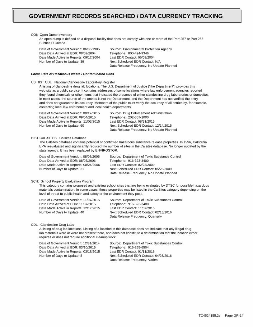
ODI: Open Dump InventoryAn open dump is defined as a disposal facility that does not comply with one or more of the Part 257 or Part 258Subtitle D Criteria.
Date of Government Version: 06/30/1985Date Data Arrived at EDR: 08/09/2004Date Made Active in Reports: 09/17/2004Number of Days to Update: 39
Source: Environmental Protection AgencyTelephone: 800-424-9346Last EDR Contact: 06/09/2004Next Scheduled EDR Contact: N/AData Release Frequency: No Update Planned
Local Lists of Hazardous waste / Contaminated Sites
US HIST CDL: National Clandestine Laboratory RegisterA listing of clandestine drug lab locations. The U.S. Department of Justice ("the Department") provides thisweb site as a public service. It contains addresses of some locations where law enforcement agencies reportedthey found chemicals or other items that indicated the presence of either clandestine drug laboratories or dumpsites.In most cases, the source of the entries is not the Department, and the Department has not verified the entryand does not guarantee its accuracy. Members of the public must verify the accuracy of all entries by, for example,contacting local law enforcement and local health departments.
Date of Government Version: 08/12/2015Date Data Arrived at EDR: 09/04/2015Date Made Active in Reports: 11/03/2015Number of Days to Update: 60
Source: Drug Enforcement AdministrationTelephone: 202-307-1000Last EDR Contact: 08/31/2015Next Scheduled EDR Contact: 12/14/2015Data Release Frequency: No Update Planned
HIST CAL-SITES: Calsites DatabaseThe Calsites database contains potential or confirmed hazardous substance release properties. In 1996, CaliforniaEPA reevaluated and significantly reduced the number of sites in the Calsites database. No longer updated by thestate agency. It has been replaced by ENVIROSTOR.
Date of Government Version: 08/08/2005Date Data Arrived at EDR: 08/03/2006Date Made Active in Reports: 08/24/2006Number of Days to Update: 21
Source: Department of Toxic Substance ControlTelephone: 916-323-3400Last EDR Contact: 02/23/2009Next Scheduled EDR Contact: 05/25/2009Data Release Frequency: No Update Planned
SCH: School Property Evaluation ProgramThis category contains proposed and existing school sites that are being evaluated by DTSC for possible hazardousmaterials contamination. In some cases, these properties may be listed in the CalSites category depending on thelevel of threat to public health and safety or the environment they pose.
Date of Government Version: 11/07/2015Date Data Arrived at EDR: 11/07/2015Date Made Active in Reports: 12/17/2015Number of Days to Update: 40
Source: Department of Toxic Substances ControlTelephone: 916-323-3400Last EDR Contact: 11/07/2015Next Scheduled EDR Contact: 02/15/2016Data Release Frequency: Quarterly
CDL: Clandestine Drug LabsA listing of drug lab locations. Listing of a location in this database does not indicate that any illegal druglab materials were or were not present there, and does not constitute a determination that the location eitherrequires or does not require additional cleanup work.
Date of Government Version: 12/31/2014Date Data Arrived at EDR: 03/10/2015Date Made Active in Reports: 03/18/2015Number of Days to Update: 8
Source: Department of Toxic Substances ControlTelephone: 916-255-6504Last EDR Contact: 01/11/2016Next Scheduled EDR Contact: 04/25/2016Data Release Frequency: Varies
TC4524155.2s Page GR-14
GOVERNMENT RECORDS SEARCHED / DATA CURRENCY TRACKING

TOXIC PITS: Toxic Pits Cleanup Act SitesToxic PITS Cleanup Act Sites. TOXIC PITS identifies sites suspected of containing hazardous substances where cleanuphas not yet been completed.
Date of Government Version: 07/01/1995Date Data Arrived at EDR: 08/30/1995Date Made Active in Reports: 09/26/1995Number of Days to Update: 27
Source: State Water Resources Control BoardTelephone: 916-227-4364Last EDR Contact: 01/26/2009Next Scheduled EDR Contact: 04/27/2009Data Release Frequency: No Update Planned
US CDL: Clandestine Drug LabsA listing of clandestine drug lab locations. The U.S. Department of Justice ("the Department") provides thisweb site as a public service. It contains addresses of some locations where law enforcement agencies reportedthey found chemicals or other items that indicated the presence of either clandestine drug laboratories or dumpsites.In most cases, the source of the entries is not the Department, and the Department has not verified the entryand does not guarantee its accuracy. Members of the public must verify the accuracy of all entries by, for example,contacting local law enforcement and local health departments.
Date of Government Version: 08/12/2015Date Data Arrived at EDR: 09/04/2015Date Made Active in Reports: 11/03/2015Number of Days to Update: 60
Source: Drug Enforcement AdministrationTelephone: 202-307-1000Last EDR Contact: 11/25/2015Next Scheduled EDR Contact: 03/14/2016Data Release Frequency: Quarterly
Local Lists of Registered Storage Tanks
SWEEPS UST: SWEEPS UST ListingStatewide Environmental Evaluation and Planning System. This underground storage tank listing was updated andmaintained by a company contacted by the SWRCB in the early 1990’s. The listing is no longer updated or maintained.The local agency is the contact for more information on a site on the SWEEPS list.
Date of Government Version: 06/01/1994Date Data Arrived at EDR: 07/07/2005Date Made Active in Reports: 08/11/2005Number of Days to Update: 35
Source: State Water Resources Control BoardTelephone: N/ALast EDR Contact: 06/03/2005Next Scheduled EDR Contact: N/AData Release Frequency: No Update Planned
UST MENDOCINO: Mendocino County UST DatabaseA listing of underground storage tank locations in Mendocino County.
Date of Government Version: 11/25/2015Date Data Arrived at EDR: 12/01/2015Date Made Active in Reports: 12/17/2015Number of Days to Update: 16
Source: Department of Public HealthTelephone: 707-463-4466Last EDR Contact: 11/23/2015Next Scheduled EDR Contact: 03/14/2016Data Release Frequency: Annually
HIST UST: Hazardous Substance Storage Container DatabaseThe Hazardous Substance Storage Container Database is a historical listing of UST sites. Refer to local/countysource for current data.
Date of Government Version: 10/15/1990Date Data Arrived at EDR: 01/25/1991Date Made Active in Reports: 02/12/1991Number of Days to Update: 18
Source: State Water Resources Control BoardTelephone: 916-341-5851Last EDR Contact: 07/26/2001Next Scheduled EDR Contact: N/AData Release Frequency: No Update Planned
CA FID UST: Facility Inventory DatabaseThe Facility Inventory Database (FID) contains a historical listing of active and inactive underground storagetank locations from the State Water Resource Control Board. Refer to local/county source for current data.
TC4524155.2s Page GR-15
GOVERNMENT RECORDS SEARCHED / DATA CURRENCY TRACKING

Date of Government Version: 10/31/1994Date Data Arrived at EDR: 09/05/1995Date Made Active in Reports: 09/29/1995Number of Days to Update: 24
Source: California Environmental Protection AgencyTelephone: 916-341-5851Last EDR Contact: 12/28/1998Next Scheduled EDR Contact: N/AData Release Frequency: No Update Planned
Local Land Records
LIENS: Environmental Liens ListingA listing of property locations with environmental liens for California where DTSC is a lien holder.
Date of Government Version: 09/08/2015Date Data Arrived at EDR: 09/10/2015Date Made Active in Reports: 10/12/2015Number of Days to Update: 32
Source: Department of Toxic Substances ControlTelephone: 916-323-3400Last EDR Contact: 12/04/2015Next Scheduled EDR Contact: 03/21/2016Data Release Frequency: Varies
LIENS 2: CERCLA Lien InformationA Federal CERCLA (’Superfund’) lien can exist by operation of law at any site or property at which EPA has spentSuperfund monies. These monies are spent to investigate and address releases and threatened releases of contamination.CERCLIS provides information as to the identity of these sites and properties.
Date of Government Version: 02/18/2014Date Data Arrived at EDR: 03/18/2014Date Made Active in Reports: 04/24/2014Number of Days to Update: 37
Source: Environmental Protection AgencyTelephone: 202-564-6023Last EDR Contact: 10/30/2015Next Scheduled EDR Contact: 02/08/2016Data Release Frequency: Varies
DEED: Deed Restriction ListingSite Mitigation and Brownfields Reuse Program Facility Sites with Deed Restrictions & Hazardous Waste ManagementProgram Facility Sites with Deed / Land Use Restriction. The DTSC Site Mitigation and Brownfields Reuse Program(SMBRP) list includes sites cleaned up under the program’s oversight and generally does not include currentor former hazardous waste facilities that required a hazardous waste facility permit. The list represents deedrestrictions that are active. Some sites have multiple deed restrictions. The DTSC Hazardous Waste ManagementProgram (HWMP) has developed a list of current or former hazardous waste facilities that have a recorded landuse restriction at the local county recorder’s office. The land use restrictions on this list were required bythe DTSC HWMP as a result of the presence of hazardous substances that remain on site after the facility (orpart of the facility) has been closed or cleaned up. The types of land use restriction include deed notice, deedrestriction, or a land use restriction that binds current and future owners.
Date of Government Version: 12/07/2015Date Data Arrived at EDR: 12/08/2015Date Made Active in Reports: 01/21/2016Number of Days to Update: 44
Source: DTSC and SWRCBTelephone: 916-323-3400Last EDR Contact: 12/08/2015Next Scheduled EDR Contact: 12/21/2015Data Release Frequency: Semi-Annually
Records of Emergency Release Reports
HMIRS: Hazardous Materials Information Reporting SystemHazardous Materials Incident Report System. HMIRS contains hazardous material spill incidents reported to DOT.
Date of Government Version: 06/24/2015Date Data Arrived at EDR: 06/26/2015Date Made Active in Reports: 09/02/2015Number of Days to Update: 68
Source: U.S. Department of TransportationTelephone: 202-366-4555Last EDR Contact: 12/30/2015Next Scheduled EDR Contact: 04/11/2016Data Release Frequency: Annually
CHMIRS: California Hazardous Material Incident Report SystemCalifornia Hazardous Material Incident Reporting System. CHMIRS contains information on reported hazardous materialincidents (accidental releases or spills).
TC4524155.2s Page GR-16
GOVERNMENT RECORDS SEARCHED / DATA CURRENCY TRACKING

Date of Government Version: 09/25/2015Date Data Arrived at EDR: 10/27/2015Date Made Active in Reports: 11/16/2015Number of Days to Update: 20
Source: Office of Emergency ServicesTelephone: 916-845-8400Last EDR Contact: 10/27/2015Next Scheduled EDR Contact: 11/09/2015Data Release Frequency: Varies
LDS: Land Disposal Sites ListingThe Land Disposal program regulates of waste discharge to land for treatment, storage and disposal in waste managementunits.
Date of Government Version: 10/21/2015Date Data Arrived at EDR: 10/22/2015Date Made Active in Reports: 11/05/2015Number of Days to Update: 14
Source: State Water Qualilty Control BoardTelephone: 866-480-1028Last EDR Contact: 12/14/2015Next Scheduled EDR Contact: 03/28/2016Data Release Frequency: Quarterly
MCS: Military Cleanup Sites ListingThe State Water Resources Control Board and nine Regional Water Quality Control Boards partner with the Departmentof Defense (DoD) through the Defense and State Memorandum of Agreement (DSMOA) to oversee the investigationand remediation of water quality issues at military facilities.
Date of Government Version: 10/21/2015Date Data Arrived at EDR: 10/22/2015Date Made Active in Reports: 11/05/2015Number of Days to Update: 14
Source: State Water Resources Control BoardTelephone: 866-480-1028Last EDR Contact: 12/14/2015Next Scheduled EDR Contact: 03/28/2016Data Release Frequency: Quarterly
SPILLS 90: SPILLS90 data from FirstSearchSpills 90 includes those spill and release records available exclusively from FirstSearch databases. Typically,they may include chemical, oil and/or hazardous substance spills recorded after 1990. Duplicate records that arealready included in EDR incident and release records are not included in Spills 90.
Date of Government Version: 06/06/2012Date Data Arrived at EDR: 01/03/2013Date Made Active in Reports: 02/22/2013Number of Days to Update: 50
Source: FirstSearchTelephone: N/ALast EDR Contact: 01/03/2013Next Scheduled EDR Contact: N/AData Release Frequency: No Update Planned
Other Ascertainable Records
RCRA NonGen / NLR: RCRA - Non Generators / No Longer RegulatedRCRAInfo is EPA’s comprehensive information system, providing access to data supporting the Resource Conservationand Recovery Act (RCRA) of 1976 and the Hazardous and Solid Waste Amendments (HSWA) of 1984. The databaseincludes selective information on sites which generate, transport, store, treat and/or dispose of hazardous wasteas defined by the Resource Conservation and Recovery Act (RCRA). Non-Generators do not presently generate hazardouswaste.
Date of Government Version: 06/09/2015Date Data Arrived at EDR: 06/26/2015Date Made Active in Reports: 09/16/2015Number of Days to Update: 82
Source: Environmental Protection AgencyTelephone: (415) 495-8895Last EDR Contact: 12/18/2015Next Scheduled EDR Contact: 04/11/2016Data Release Frequency: Varies
FUDS: Formerly Used Defense SitesThe listing includes locations of Formerly Used Defense Sites properties where the US Army Corps of Engineersis actively working or will take necessary cleanup actions.
Date of Government Version: 01/31/2015Date Data Arrived at EDR: 07/08/2015Date Made Active in Reports: 10/13/2015Number of Days to Update: 97
Source: U.S. Army Corps of EngineersTelephone: 202-528-4285Last EDR Contact: 12/11/2015Next Scheduled EDR Contact: 03/21/2016Data Release Frequency: Varies
TC4524155.2s Page GR-17
GOVERNMENT RECORDS SEARCHED / DATA CURRENCY TRACKING

DOD: Department of Defense SitesThis data set consists of federally owned or administered lands, administered by the Department of Defense, thathave any area equal to or greater than 640 acres of the United States, Puerto Rico, and the U.S. Virgin Islands.
Date of Government Version: 12/31/2005Date Data Arrived at EDR: 11/10/2006Date Made Active in Reports: 01/11/2007Number of Days to Update: 62
Source: USGSTelephone: 888-275-8747Last EDR Contact: 01/15/2016Next Scheduled EDR Contact: 04/25/2016Data Release Frequency: Semi-Annually
FEDLAND: Federal and Indian LandsFederally and Indian administrated lands of the United States. Lands included are administrated by: Army Corpsof Engineers, Bureau of Reclamation, National Wild and Scenic River, National Wildlife Refuge, Public Domain Land,Wilderness, Wilderness Study Area, Wildlife Management Area, Bureau of Indian Affairs, Bureau of Land Management,Department of Justice, Forest Service, Fish and Wildlife Service, National Park Service.
Date of Government Version: 12/31/2005Date Data Arrived at EDR: 02/06/2006Date Made Active in Reports: 01/11/2007Number of Days to Update: 339
Source: U.S. Geological SurveyTelephone: 888-275-8747Last EDR Contact: 01/15/2016Next Scheduled EDR Contact: 04/25/2016Data Release Frequency: N/A
SCRD DRYCLEANERS: State Coalition for Remediation of Drycleaners ListingThe State Coalition for Remediation of Drycleaners was established in 1998, with support from the U.S. EPA Officeof Superfund Remediation and Technology Innovation. It is comprised of representatives of states with establisheddrycleaner remediation programs. Currently the member states are Alabama, Connecticut, Florida, Illinois, Kansas,Minnesota, Missouri, North Carolina, Oregon, South Carolina, Tennessee, Texas, and Wisconsin.
Date of Government Version: 03/07/2011Date Data Arrived at EDR: 03/09/2011Date Made Active in Reports: 05/02/2011Number of Days to Update: 54
Source: Environmental Protection AgencyTelephone: 615-532-8599Last EDR Contact: 11/19/2015Next Scheduled EDR Contact: 02/29/2016Data Release Frequency: Varies
US FIN ASSUR: Financial Assurance InformationAll owners and operators of facilities that treat, store, or dispose of hazardous waste are required to provideproof that they will have sufficient funds to pay for the clean up, closure, and post-closure care of their facilities.
Date of Government Version: 09/01/2015Date Data Arrived at EDR: 09/03/2015Date Made Active in Reports: 11/03/2015Number of Days to Update: 61
Source: Environmental Protection AgencyTelephone: 202-566-1917Last EDR Contact: 11/13/2015Next Scheduled EDR Contact: 02/29/2016Data Release Frequency: Quarterly
EPA WATCH LIST: EPA WATCH LISTEPA maintains a "Watch List" to facilitate dialogue between EPA, state and local environmental agencies on enforcementmatters relating to facilities with alleged violations identified as either significant or high priority. Beingon the Watch List does not mean that the facility has actually violated the law only that an investigation byEPA or a state or local environmental agency has led those organizations to allege that an unproven violationhas in fact occurred. Being on the Watch List does not represent a higher level of concern regarding the allegedviolations that were detected, but instead indicates cases requiring additional dialogue between EPA, state andlocal agencies - primarily because of the length of time the alleged violation has gone unaddressed or unresolved.
Date of Government Version: 08/30/2013Date Data Arrived at EDR: 03/21/2014Date Made Active in Reports: 06/17/2014Number of Days to Update: 88
Source: Environmental Protection AgencyTelephone: 617-520-3000Last EDR Contact: 11/10/2015Next Scheduled EDR Contact: 02/22/2016Data Release Frequency: Quarterly
TC4524155.2s Page GR-18
GOVERNMENT RECORDS SEARCHED / DATA CURRENCY TRACKING

2020 COR ACTION: 2020 Corrective Action Program ListThe EPA has set ambitious goals for the RCRA Corrective Action program by creating the 2020 Corrective ActionUniverse. This RCRA cleanup baseline includes facilities expected to need corrective action. The 2020 universecontains a wide variety of sites. Some properties are heavily contaminated while others were contaminated buthave since been cleaned up. Still others have not been fully investigated yet, and may require little or no remediation.Inclusion in the 2020 Universe does not necessarily imply failure on the part of a facility to meet its RCRA obligations.
Date of Government Version: 04/22/2013Date Data Arrived at EDR: 03/03/2015Date Made Active in Reports: 03/09/2015Number of Days to Update: 6
Source: Environmental Protection AgencyTelephone: 703-308-4044Last EDR Contact: 11/13/2015Next Scheduled EDR Contact: 02/22/2016Data Release Frequency: Varies
TSCA: Toxic Substances Control ActToxic Substances Control Act. TSCA identifies manufacturers and importers of chemical substances included on theTSCA Chemical Substance Inventory list. It includes data on the production volume of these substances by plantsite.
Date of Government Version: 12/31/2012Date Data Arrived at EDR: 01/15/2015Date Made Active in Reports: 01/29/2015Number of Days to Update: 14
Source: EPATelephone: 202-260-5521Last EDR Contact: 12/23/2015Next Scheduled EDR Contact: 04/04/2016Data Release Frequency: Every 4 Years
TRIS: Toxic Chemical Release Inventory SystemToxic Release Inventory System. TRIS identifies facilities which release toxic chemicals to the air, water andland in reportable quantities under SARA Title III Section 313.
Date of Government Version: 12/31/2013Date Data Arrived at EDR: 02/12/2015Date Made Active in Reports: 06/02/2015Number of Days to Update: 110
Source: EPATelephone: 202-566-0250Last EDR Contact: 11/24/2015Next Scheduled EDR Contact: 03/07/2016Data Release Frequency: Annually
SSTS: Section 7 Tracking SystemsSection 7 of the Federal Insecticide, Fungicide and Rodenticide Act, as amended (92 Stat. 829) requires allregistered pesticide-producing establishments to submit a report to the Environmental Protection Agency by March1st each year. Each establishment must report the types and amounts of pesticides, active ingredients and devicesbeing produced, and those having been produced and sold or distributed in the past year.
Date of Government Version: 12/31/2009Date Data Arrived at EDR: 12/10/2010Date Made Active in Reports: 02/25/2011Number of Days to Update: 77
Source: EPATelephone: 202-564-4203Last EDR Contact: 10/26/2015Next Scheduled EDR Contact: 02/08/2016Data Release Frequency: Annually
ROD: Records Of DecisionRecord of Decision. ROD documents mandate a permanent remedy at an NPL (Superfund) site containing technicaland health information to aid in the cleanup.
Date of Government Version: 11/25/2013Date Data Arrived at EDR: 12/12/2013Date Made Active in Reports: 02/24/2014Number of Days to Update: 74
Source: EPATelephone: 703-416-0223Last EDR Contact: 12/11/2015Next Scheduled EDR Contact: 03/21/2016Data Release Frequency: Annually
RMP: Risk Management Plans
TC4524155.2s Page GR-19
GOVERNMENT RECORDS SEARCHED / DATA CURRENCY TRACKING

When Congress passed the Clean Air Act Amendments of 1990, it required EPA to publish regulations and guidancefor chemical accident prevention at facilities using extremely hazardous substances. The Risk Management ProgramRule (RMP Rule) was written to implement Section 112(r) of these amendments. The rule, which built upon existingindustry codes and standards, requires companies of all sizes that use certain flammable and toxic substancesto develop a Risk Management Program, which includes a(n): Hazard assessment that details the potential effectsof an accidental release, an accident history of the last five years, and an evaluation of worst-case and alternativeaccidental releases; Prevention program that includes safety precautions and maintenance, monitoring, and employeetraining measures; and Emergency response program that spells out emergency health care, employee training measuresand procedures for informing the public and response agencies (e.g the fire department) should an accident occur.
Date of Government Version: 08/01/2015Date Data Arrived at EDR: 08/26/2015Date Made Active in Reports: 11/03/2015Number of Days to Update: 69
Source: Environmental Protection AgencyTelephone: 202-564-8600Last EDR Contact: 10/26/2015Next Scheduled EDR Contact: 02/08/2016Data Release Frequency: Varies
RAATS: RCRA Administrative Action Tracking SystemRCRA Administration Action Tracking System. RAATS contains records based on enforcement actions issued under RCRApertaining to major violators and includes administrative and civil actions brought by the EPA. For administrationactions after September 30, 1995, data entry in the RAATS database was discontinued. EPA will retain a copy ofthe database for historical records. It was necessary to terminate RAATS because a decrease in agency resourcesmade it impossible to continue to update the information contained in the database.
Date of Government Version: 04/17/1995Date Data Arrived at EDR: 07/03/1995Date Made Active in Reports: 08/07/1995Number of Days to Update: 35
Source: EPATelephone: 202-564-4104Last EDR Contact: 06/02/2008Next Scheduled EDR Contact: 09/01/2008Data Release Frequency: No Update Planned
PRP: Potentially Responsible PartiesA listing of verified Potentially Responsible Parties
Date of Government Version: 10/25/2013Date Data Arrived at EDR: 10/17/2014Date Made Active in Reports: 10/20/2014Number of Days to Update: 3
Source: EPATelephone: 202-564-6023Last EDR Contact: 11/13/2015Next Scheduled EDR Contact: 02/22/2016Data Release Frequency: Quarterly
PADS: PCB Activity Database SystemPCB Activity Database. PADS Identifies generators, transporters, commercial storers and/or brokers and disposersof PCB’s who are required to notify the EPA of such activities.
Date of Government Version: 07/01/2014Date Data Arrived at EDR: 10/15/2014Date Made Active in Reports: 11/17/2014Number of Days to Update: 33
Source: EPATelephone: 202-566-0500Last EDR Contact: 01/12/2016Next Scheduled EDR Contact: 04/25/2016Data Release Frequency: Annually
ICIS: Integrated Compliance Information SystemThe Integrated Compliance Information System (ICIS) supports the information needs of the national enforcementand compliance program as well as the unique needs of the National Pollutant Discharge Elimination System (NPDES)program.
Date of Government Version: 01/23/2015Date Data Arrived at EDR: 02/06/2015Date Made Active in Reports: 03/09/2015Number of Days to Update: 31
Source: Environmental Protection AgencyTelephone: 202-564-5088Last EDR Contact: 01/08/2016Next Scheduled EDR Contact: 04/25/2016Data Release Frequency: Quarterly
TC4524155.2s Page GR-20
GOVERNMENT RECORDS SEARCHED / DATA CURRENCY TRACKING

FTTS: FIFRA/ TSCA Tracking System - FIFRA (Federal Insecticide, Fungicide, & Rodenticide Act)/TSCA (Toxic Substances Control Act)FTTS tracks administrative cases and pesticide enforcement actions and compliance activities related to FIFRA,TSCA and EPCRA (Emergency Planning and Community Right-to-Know Act). To maintain currency, EDR contacts theAgency on a quarterly basis.
Date of Government Version: 04/09/2009Date Data Arrived at EDR: 04/16/2009Date Made Active in Reports: 05/11/2009Number of Days to Update: 25
Source: EPA/Office of Prevention, Pesticides and Toxic SubstancesTelephone: 202-566-1667Last EDR Contact: 11/18/2015Next Scheduled EDR Contact: 03/07/2016Data Release Frequency: Quarterly
FTTS INSP: FIFRA/ TSCA Tracking System - FIFRA (Federal Insecticide, Fungicide, & Rodenticide Act)/TSCA (Toxic Substances Control Act)A listing of FIFRA/TSCA Tracking System (FTTS) inspections and enforcements.
Date of Government Version: 04/09/2009Date Data Arrived at EDR: 04/16/2009Date Made Active in Reports: 05/11/2009Number of Days to Update: 25
Source: EPATelephone: 202-566-1667Last EDR Contact: 11/18/2015Next Scheduled EDR Contact: 03/07/2016Data Release Frequency: Quarterly
MLTS: Material Licensing Tracking SystemMLTS is maintained by the Nuclear Regulatory Commission and contains a list of approximately 8,100 sites whichpossess or use radioactive materials and which are subject to NRC licensing requirements. To maintain currency,EDR contacts the Agency on a quarterly basis.
Date of Government Version: 06/26/2015Date Data Arrived at EDR: 07/10/2015Date Made Active in Reports: 10/13/2015Number of Days to Update: 95
Source: Nuclear Regulatory CommissionTelephone: 301-415-7169Last EDR Contact: 12/07/2015Next Scheduled EDR Contact: 03/21/2016Data Release Frequency: Quarterly
COAL ASH DOE: Steam-Electric Plant Operation DataA listing of power plants that store ash in surface ponds.
Date of Government Version: 12/31/2005Date Data Arrived at EDR: 08/07/2009Date Made Active in Reports: 10/22/2009Number of Days to Update: 76
Source: Department of EnergyTelephone: 202-586-8719Last EDR Contact: 01/13/2016Next Scheduled EDR Contact: 04/25/2016Data Release Frequency: Varies
COAL ASH EPA: Coal Combustion Residues Surface Impoundments ListA listing of coal combustion residues surface impoundments with high hazard potential ratings.
Date of Government Version: 07/01/2014Date Data Arrived at EDR: 09/10/2014Date Made Active in Reports: 10/20/2014Number of Days to Update: 40
Source: Environmental Protection AgencyTelephone: N/ALast EDR Contact: 12/11/2015Next Scheduled EDR Contact: 03/21/2016Data Release Frequency: Varies
PCB TRANSFORMER: PCB Transformer Registration DatabaseThe database of PCB transformer registrations that includes all PCB registration submittals.
Date of Government Version: 02/01/2011Date Data Arrived at EDR: 10/19/2011Date Made Active in Reports: 01/10/2012Number of Days to Update: 83
Source: Environmental Protection AgencyTelephone: 202-566-0517Last EDR Contact: 10/29/2015Next Scheduled EDR Contact: 02/08/2016Data Release Frequency: Varies
RADINFO: Radiation Information DatabaseThe Radiation Information Database (RADINFO) contains information about facilities that are regulated by U.S.Environmental Protection Agency (EPA) regulations for radiation and radioactivity.
TC4524155.2s Page GR-21
GOVERNMENT RECORDS SEARCHED / DATA CURRENCY TRACKING
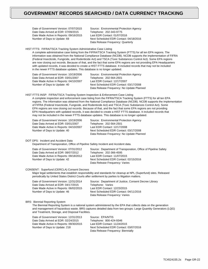
Date of Government Version: 07/07/2015Date Data Arrived at EDR: 07/09/2015Date Made Active in Reports: 09/16/2015Number of Days to Update: 69
Source: Environmental Protection AgencyTelephone: 202-343-9775Last EDR Contact: 01/07/2016Next Scheduled EDR Contact: 04/18/2016Data Release Frequency: Quarterly
HIST FTTS: FIFRA/TSCA Tracking System Administrative Case ListingA complete administrative case listing from the FIFRA/TSCA Tracking System (FTTS) for all ten EPA regions. Theinformation was obtained from the National Compliance Database (NCDB). NCDB supports the implementation of FIFRA(Federal Insecticide, Fungicide, and Rodenticide Act) and TSCA (Toxic Substances Control Act). Some EPA regionsare now closing out records. Because of that, and the fact that some EPA regions are not providing EPA Headquarterswith updated records, it was decided to create a HIST FTTS database. It included records that may not be includedin the newer FTTS database updates. This database is no longer updated.
Date of Government Version: 10/19/2006Date Data Arrived at EDR: 03/01/2007Date Made Active in Reports: 04/10/2007Number of Days to Update: 40
Source: Environmental Protection AgencyTelephone: 202-564-2501Last EDR Contact: 12/17/2007Next Scheduled EDR Contact: 03/17/2008Data Release Frequency: No Update Planned
HIST FTTS INSP: FIFRA/TSCA Tracking System Inspection & Enforcement Case ListingA complete inspection and enforcement case listing from the FIFRA/TSCA Tracking System (FTTS) for all ten EPAregions. The information was obtained from the National Compliance Database (NCDB). NCDB supports the implementationof FIFRA (Federal Insecticide, Fungicide, and Rodenticide Act) and TSCA (Toxic Substances Control Act). SomeEPA regions are now closing out records. Because of that, and the fact that some EPA regions are not providingEPA Headquarters with updated records, it was decided to create a HIST FTTS database. It included records thatmay not be included in the newer FTTS database updates. This database is no longer updated.
Date of Government Version: 10/19/2006Date Data Arrived at EDR: 03/01/2007Date Made Active in Reports: 04/10/2007Number of Days to Update: 40
Source: Environmental Protection AgencyTelephone: 202-564-2501Last EDR Contact: 12/17/2008Next Scheduled EDR Contact: 03/17/2008Data Release Frequency: No Update Planned
DOT OPS: Incident and Accident DataDepartment of Transporation, Office of Pipeline Safety Incident and Accident data.
Date of Government Version: 07/31/2012Date Data Arrived at EDR: 08/07/2012Date Made Active in Reports: 09/18/2012Number of Days to Update: 42
Source: Department of Transporation, Office of Pipeline SafetyTelephone: 202-366-4595Last EDR Contact: 11/07/2015Next Scheduled EDR Contact: 02/15/2016Data Release Frequency: Varies
CONSENT: Superfund (CERCLA) Consent DecreesMajor legal settlements that establish responsibility and standards for cleanup at NPL (Superfund) sites. Releasedperiodically by United States District Courts after settlement by parties to litigation matters.
Date of Government Version: 12/31/2014Date Data Arrived at EDR: 04/17/2015Date Made Active in Reports: 06/02/2015Number of Days to Update: 46
Source: Department of Justice, Consent Decree LibraryTelephone: VariesLast EDR Contact: 12/23/2015Next Scheduled EDR Contact: 04/11/2016Data Release Frequency: Varies
BRS: Biennial Reporting SystemThe Biennial Reporting System is a national system administered by the EPA that collects data on the generationand management of hazardous waste. BRS captures detailed data from two groups: Large Quantity Generators (LQG)and Treatment, Storage, and Disposal Facilities.
Date of Government Version: 12/31/2013Date Data Arrived at EDR: 02/24/2015Date Made Active in Reports: 09/30/2015Number of Days to Update: 218
Source: EPA/NTISTelephone: 800-424-9346Last EDR Contact: 11/24/2015Next Scheduled EDR Contact: 03/07/2016Data Release Frequency: Biennially
TC4524155.2s Page GR-22
GOVERNMENT RECORDS SEARCHED / DATA CURRENCY TRACKING

INDIAN RESERV: Indian ReservationsThis map layer portrays Indian administered lands of the United States that have any area equal to or greaterthan 640 acres.
Date of Government Version: 12/31/2005Date Data Arrived at EDR: 12/08/2006Date Made Active in Reports: 01/11/2007Number of Days to Update: 34
Source: USGSTelephone: 202-208-3710Last EDR Contact: 01/15/2016Next Scheduled EDR Contact: 04/25/2016Data Release Frequency: Semi-Annually
UMTRA: Uranium Mill Tailings SitesUranium ore was mined by private companies for federal government use in national defense programs. When the millsshut down, large piles of the sand-like material (mill tailings) remain after uranium has been extracted fromthe ore. Levels of human exposure to radioactive materials from the piles are low; however, in some cases tailingswere used as construction materials before the potential health hazards of the tailings were recognized.
Date of Government Version: 09/14/2010Date Data Arrived at EDR: 10/07/2011Date Made Active in Reports: 03/01/2012Number of Days to Update: 146
Source: Department of EnergyTelephone: 505-845-0011Last EDR Contact: 11/19/2015Next Scheduled EDR Contact: 03/07/2016Data Release Frequency: Varies
LEAD SMELTER 1: Lead Smelter SitesA listing of former lead smelter site locations.
Date of Government Version: 11/25/2014Date Data Arrived at EDR: 11/26/2014Date Made Active in Reports: 01/29/2015Number of Days to Update: 64
Source: Environmental Protection AgencyTelephone: 703-603-8787Last EDR Contact: 01/08/2016Next Scheduled EDR Contact: 04/18/2016Data Release Frequency: Varies
LEAD SMELTER 2: Lead Smelter SitesA list of several hundred sites in the U.S. where secondary lead smelting was done from 1931and 1964. These sitesmay pose a threat to public health through ingestion or inhalation of contaminated soil or dust
Date of Government Version: 04/05/2001Date Data Arrived at EDR: 10/27/2010Date Made Active in Reports: 12/02/2010Number of Days to Update: 36
Source: American Journal of Public HealthTelephone: 703-305-6451Last EDR Contact: 12/02/2009Next Scheduled EDR Contact: N/AData Release Frequency: No Update Planned
US AIRS (AFS): Aerometric Information Retrieval System Facility Subsystem (AFS)The database is a sub-system of Aerometric Information Retrieval System (AIRS). AFS contains compliance dataon air pollution point sources regulated by the U.S. EPA and/or state and local air regulatory agencies. Thisinformation comes from source reports by various stationary sources of air pollution, such as electric power plants,steel mills, factories, and universities, and provides information about the air pollutants they produce. Action,air program, air program pollutant, and general level plant data. It is used to track emissions and compliancedata from industrial plants.
Date of Government Version: 10/20/2015Date Data Arrived at EDR: 10/27/2015Date Made Active in Reports: 01/04/2016Number of Days to Update: 69
Source: EPATelephone: 202-564-2496Last EDR Contact: 12/22/2015Next Scheduled EDR Contact: 04/11/2016Data Release Frequency: Annually
US AIRS MINOR: Air Facility System DataA listing of minor source facilities.
Date of Government Version: 10/20/2015Date Data Arrived at EDR: 10/27/2015Date Made Active in Reports: 01/04/2016Number of Days to Update: 69
Source: EPATelephone: 202-564-2496Last EDR Contact: 12/22/2015Next Scheduled EDR Contact: 04/11/2016Data Release Frequency: Annually
TC4524155.2s Page GR-23
GOVERNMENT RECORDS SEARCHED / DATA CURRENCY TRACKING

US MINES: Mines Master Index FileContains all mine identification numbers issued for mines active or opened since 1971. The data also includesviolation information.
Date of Government Version: 08/18/2015Date Data Arrived at EDR: 09/01/2015Date Made Active in Reports: 01/04/2016Number of Days to Update: 125
Source: Department of Labor, Mine Safety and Health AdministrationTelephone: 303-231-5959Last EDR Contact: 12/03/2015Next Scheduled EDR Contact: 03/14/2016Data Release Frequency: Semi-Annually
US MINES 2: Ferrous and Nonferrous Metal Mines Database ListingThis map layer includes ferrous (ferrous metal mines are facilities that extract ferrous metals, such as ironore or molybdenum) and nonferrous (Nonferrous metal mines are facilities that extract nonferrous metals, suchas gold, silver, copper, zinc, and lead) metal mines in the United States.
Date of Government Version: 12/05/2005Date Data Arrived at EDR: 02/29/2008Date Made Active in Reports: 04/18/2008Number of Days to Update: 49
Source: USGSTelephone: 703-648-7709Last EDR Contact: 12/04/2015Next Scheduled EDR Contact: 03/14/2016Data Release Frequency: Varies
US MINES 3: Active Mines & Mineral Plants Database ListingActive Mines and Mineral Processing Plant operations for commodities monitored by the Minerals Information Teamof the USGS.
Date of Government Version: 04/14/2011Date Data Arrived at EDR: 06/08/2011Date Made Active in Reports: 09/13/2011Number of Days to Update: 97
Source: USGSTelephone: 703-648-7709Last EDR Contact: 12/04/2015Next Scheduled EDR Contact: 03/14/2016Data Release Frequency: Varies
FINDS: Facility Index System/Facility Registry SystemFacility Index System. FINDS contains both facility information and ’pointers’ to other sources that contain moredetail. EDR includes the following FINDS databases in this report: PCS (Permit Compliance System), AIRS (AerometricInformation Retrieval System), DOCKET (Enforcement Docket used to manage and track information on civil judicialenforcement cases for all environmental statutes), FURS (Federal Underground Injection Control), C-DOCKET (CriminalDocket System used to track criminal enforcement actions for all environmental statutes), FFIS (Federal FacilitiesInformation System), STATE (State Environmental Laws and Statutes), and PADS (PCB Activity Data System).
Date of Government Version: 07/20/2015Date Data Arrived at EDR: 09/09/2015Date Made Active in Reports: 11/03/2015Number of Days to Update: 55
Source: EPATelephone: (415) 947-8000Last EDR Contact: 12/10/2015Next Scheduled EDR Contact: 03/21/2016Data Release Frequency: Quarterly
CA BOND EXP. PLAN: Bond Expenditure PlanDepartment of Health Services developed a site-specific expenditure plan as the basis for an appropriation ofHazardous Substance Cleanup Bond Act funds. It is not updated.
Date of Government Version: 01/01/1989Date Data Arrived at EDR: 07/27/1994Date Made Active in Reports: 08/02/1994Number of Days to Update: 6
Source: Department of Health ServicesTelephone: 916-255-2118Last EDR Contact: 05/31/1994Next Scheduled EDR Contact: N/AData Release Frequency: No Update Planned
CORTESE: "Cortese" Hazardous Waste & Substances Sites ListThe sites for the list are designated by the State Water Resource Control Board (LUST), the Integrated WasteBoard (SWF/LS), and the Department of Toxic Substances Control (Cal-Sites).
TC4524155.2s Page GR-24
GOVERNMENT RECORDS SEARCHED / DATA CURRENCY TRACKING

Date of Government Version: 12/28/2015Date Data Arrived at EDR: 12/29/2015Date Made Active in Reports: 01/21/2016Number of Days to Update: 23
Source: CAL EPA/Office of Emergency InformationTelephone: 916-323-3400Last EDR Contact: 12/29/2015Next Scheduled EDR Contact: 04/11/2016Data Release Frequency: Quarterly
DRYCLEANERS: Cleaner FacilitiesA list of drycleaner related facilities that have EPA ID numbers. These are facilities with certain SIC codes:power laundries, family and commercial; garment pressing and cleaner’s agents; linen supply; coin-operated laundriesand cleaning; drycleaning plants, except rugs; carpet and upholster cleaning; industrial launderers; laundry andgarment services.
Date of Government Version: 08/10/2015Date Data Arrived at EDR: 08/27/2015Date Made Active in Reports: 10/01/2015Number of Days to Update: 35
Source: Department of Toxic Substance ControlTelephone: 916-327-4498Last EDR Contact: 01/19/2016Next Scheduled EDR Contact: 03/21/2016Data Release Frequency: Annually
EMI: Emissions Inventory DataToxics and criteria pollutant emissions data collected by the ARB and local air pollution agencies.
Date of Government Version: 12/31/2013Date Data Arrived at EDR: 09/25/2015Date Made Active in Reports: 11/05/2015Number of Days to Update: 41
Source: California Air Resources BoardTelephone: 916-322-2990Last EDR Contact: 12/23/2015Next Scheduled EDR Contact: 04/04/2016Data Release Frequency: Varies
ENF: Enforcement Action ListingA listing of Water Board Enforcement Actions. Formal is everything except Oral/Verbal Communication, Notice ofViolation, Expedited Payment Letter, and Staff Enforcement Letter.
Date of Government Version: 11/18/2015Date Data Arrived at EDR: 11/23/2015Date Made Active in Reports: 01/21/2016Number of Days to Update: 59
Source: State Water Resoruces Control BoardTelephone: 916-445-9379Last EDR Contact: 11/18/2015Next Scheduled EDR Contact: 02/08/2016Data Release Frequency: Varies
Financial Assurance 1: Financial Assurance Information ListingFinancial Assurance information
Date of Government Version: 11/02/2015Date Data Arrived at EDR: 11/07/2015Date Made Active in Reports: 12/17/2015Number of Days to Update: 40
Source: Department of Toxic Substances ControlTelephone: 916-255-3628Last EDR Contact: 10/26/2015Next Scheduled EDR Contact: 02/08/2016Data Release Frequency: Varies
Financial Assurance 2: Financial Assurance Information ListingA listing of financial assurance information for solid waste facilities. Financial assurance is intended to ensurethat resources are available to pay for the cost of closure, post-closure care, and corrective measures if theowner or operator of a regulated facility is unable or unwilling to pay.
Date of Government Version: 11/18/2015Date Data Arrived at EDR: 11/23/2015Date Made Active in Reports: 01/21/2016Number of Days to Update: 59
Source: California Integrated Waste Management BoardTelephone: 916-341-6066Last EDR Contact: 11/13/2015Next Scheduled EDR Contact: 02/29/2016Data Release Frequency: Varies
HAZNET: Facility and Manifest DataFacility and Manifest Data. The data is extracted from the copies of hazardous waste manifests received each yearby the DTSC. The annual volume of manifests is typically 700,000 - 1,000,000 annually, representing approximately350,000 - 500,000 shipments. Data are from the manifests submitted without correction, and therefore many containsome invalid values for data elements such as generator ID, TSD ID, waste category, and disposal method. Thisdatabase begins with calendar year 1993.
TC4524155.2s Page GR-25
GOVERNMENT RECORDS SEARCHED / DATA CURRENCY TRACKING
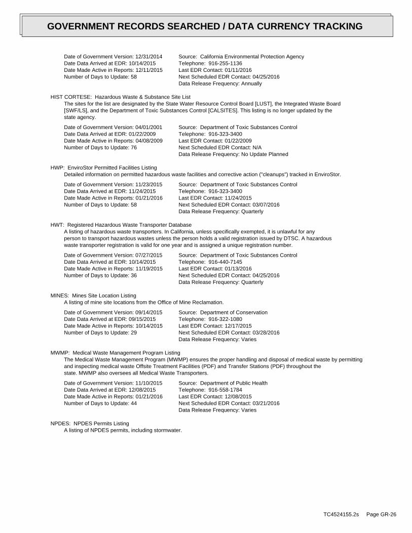
Date of Government Version: 12/31/2014Date Data Arrived at EDR: 10/14/2015Date Made Active in Reports: 12/11/2015Number of Days to Update: 58
Source: California Environmental Protection AgencyTelephone: 916-255-1136Last EDR Contact: 01/11/2016Next Scheduled EDR Contact: 04/25/2016Data Release Frequency: Annually
HIST CORTESE: Hazardous Waste & Substance Site ListThe sites for the list are designated by the State Water Resource Control Board [LUST], the Integrated Waste Board[SWF/LS], and the Department of Toxic Substances Control [CALSITES]. This listing is no longer updated by thestate agency.
Date of Government Version: 04/01/2001Date Data Arrived at EDR: 01/22/2009Date Made Active in Reports: 04/08/2009Number of Days to Update: 76
Source: Department of Toxic Substances ControlTelephone: 916-323-3400Last EDR Contact: 01/22/2009Next Scheduled EDR Contact: N/AData Release Frequency: No Update Planned
HWP: EnviroStor Permitted Facilities ListingDetailed information on permitted hazardous waste facilities and corrective action ("cleanups") tracked in EnviroStor.
Date of Government Version: 11/23/2015Date Data Arrived at EDR: 11/24/2015Date Made Active in Reports: 01/21/2016Number of Days to Update: 58
Source: Department of Toxic Substances ControlTelephone: 916-323-3400Last EDR Contact: 11/24/2015Next Scheduled EDR Contact: 03/07/2016Data Release Frequency: Quarterly
HWT: Registered Hazardous Waste Transporter DatabaseA listing of hazardous waste transporters. In California, unless specifically exempted, it is unlawful for anyperson to transport hazardous wastes unless the person holds a valid registration issued by DTSC. A hazardouswaste transporter registration is valid for one year and is assigned a unique registration number.
Date of Government Version: 07/27/2015Date Data Arrived at EDR: 10/14/2015Date Made Active in Reports: 11/19/2015Number of Days to Update: 36
Source: Department of Toxic Substances ControlTelephone: 916-440-7145Last EDR Contact: 01/13/2016Next Scheduled EDR Contact: 04/25/2016Data Release Frequency: Quarterly
MINES: Mines Site Location ListingA listing of mine site locations from the Office of Mine Reclamation.
Date of Government Version: 09/14/2015Date Data Arrived at EDR: 09/15/2015Date Made Active in Reports: 10/14/2015Number of Days to Update: 29
Source: Department of ConservationTelephone: 916-322-1080Last EDR Contact: 12/17/2015Next Scheduled EDR Contact: 03/28/2016Data Release Frequency: Varies
MWMP: Medical Waste Management Program ListingThe Medical Waste Management Program (MWMP) ensures the proper handling and disposal of medical waste by permittingand inspecting medical waste Offsite Treatment Facilities (PDF) and Transfer Stations (PDF) throughout thestate. MWMP also oversees all Medical Waste Transporters.
Date of Government Version: 11/10/2015Date Data Arrived at EDR: 12/08/2015Date Made Active in Reports: 01/21/2016Number of Days to Update: 44
Source: Department of Public HealthTelephone: 916-558-1784Last EDR Contact: 12/08/2015Next Scheduled EDR Contact: 03/21/2016Data Release Frequency: Varies
NPDES: NPDES Permits ListingA listing of NPDES permits, including stormwater.
TC4524155.2s Page GR-26
GOVERNMENT RECORDS SEARCHED / DATA CURRENCY TRACKING

Date of Government Version: 11/16/2015Date Data Arrived at EDR: 11/18/2015Date Made Active in Reports: 01/21/2016Number of Days to Update: 64
Source: State Water Resources Control BoardTelephone: 916-445-9379Last EDR Contact: 11/18/2015Next Scheduled EDR Contact: 02/29/2016Data Release Frequency: Quarterly
PEST LIC: Pesticide Regulation Licenses ListingA listing of licenses and certificates issued by the Department of Pesticide Regulation. The DPR issues licensesand/or certificates to: Persons and businesses that apply or sell pesticides; Pest control dealers and brokers;Persons who advise on agricultural pesticide applications.
Date of Government Version: 12/07/2015Date Data Arrived at EDR: 12/08/2015Date Made Active in Reports: 01/21/2016Number of Days to Update: 44
Source: Department of Pesticide RegulationTelephone: 916-445-4038Last EDR Contact: 12/08/2015Next Scheduled EDR Contact: 03/21/2016Data Release Frequency: Quarterly
PROC: Certified Processors DatabaseA listing of certified processors.
Date of Government Version: 09/14/2015Date Data Arrived at EDR: 09/15/2015Date Made Active in Reports: 10/14/2015Number of Days to Update: 29
Source: Department of ConservationTelephone: 916-323-3836Last EDR Contact: 12/17/2015Next Scheduled EDR Contact: 03/28/2016Data Release Frequency: Quarterly
NOTIFY 65: Proposition 65 RecordsListings of all Proposition 65 incidents reported to counties by the State Water Resources Control Board and theRegional Water Quality Control Board. This database is no longer updated by the reporting agency.
Date of Government Version: 08/04/2015Date Data Arrived at EDR: 08/25/2015Date Made Active in Reports: 10/05/2015Number of Days to Update: 41
Source: State Water Resources Control BoardTelephone: 916-445-3846Last EDR Contact: 12/17/2015Next Scheduled EDR Contact: 04/04/2016Data Release Frequency: No Update Planned
UIC: UIC ListingA listing of wells identified as underground injection wells, in the California Oil and Gas Wells database.
Date of Government Version: 07/23/2015Date Data Arrived at EDR: 09/15/2015Date Made Active in Reports: 10/13/2015Number of Days to Update: 28
Source: Deaprtment of ConservationTelephone: 916-445-2408Last EDR Contact: 12/18/2015Next Scheduled EDR Contact: 03/28/2016Data Release Frequency: Varies
WASTEWATER PITS: Oil Wastewater Pits ListingWater officials discovered that oil producers have been dumping chemical-laden wastewater into hundreds of unlinedpits that are operating without proper permits. Inspections completed by the Central Valley Regional Water QualityControl Board revealed the existence of previously unidentified waste sites. The water board?s review found thatmore than one-third of the region?s active disposal pits are operating without permission.
Date of Government Version: 04/15/2015Date Data Arrived at EDR: 04/17/2015Date Made Active in Reports: 06/23/2015Number of Days to Update: 67
Source: RWQCB, Central Valley RegionTelephone: 559-445-5577Last EDR Contact: 01/15/2016Next Scheduled EDR Contact: 04/25/2016Data Release Frequency: Varies
WDS: Waste Discharge SystemSites which have been issued waste discharge requirements.
TC4524155.2s Page GR-27
GOVERNMENT RECORDS SEARCHED / DATA CURRENCY TRACKING

Date of Government Version: 06/19/2007Date Data Arrived at EDR: 06/20/2007Date Made Active in Reports: 06/29/2007Number of Days to Update: 9
Source: State Water Resources Control BoardTelephone: 916-341-5227Last EDR Contact: 11/18/2015Next Scheduled EDR Contact: 03/07/2016Data Release Frequency: Quarterly
WIP: Well Investigation Program Case ListWell Investigation Program case in the San Gabriel and San Fernando Valley area.
Date of Government Version: 07/03/2009Date Data Arrived at EDR: 07/21/2009Date Made Active in Reports: 08/03/2009Number of Days to Update: 13
Source: Los Angeles Water Quality Control BoardTelephone: 213-576-6726Last EDR Contact: 12/23/2015Next Scheduled EDR Contact: 04/11/2016Data Release Frequency: Varies
EDR HIGH RISK HISTORICAL RECORDS
EDR Exclusive Records
EDR MGP: EDR Proprietary Manufactured Gas PlantsThe EDR Proprietary Manufactured Gas Plant Database includes records of coal gas plants (manufactured gas plants)compiled by EDR’s researchers. Manufactured gas sites were used in the United States from the 1800’s to 1950’sto produce a gas that could be distributed and used as fuel. These plants used whale oil, rosin, coal, or a mixtureof coal, oil, and water that also produced a significant amount of waste. Many of the byproducts of the gas production,such as coal tar (oily waste containing volatile and non-volatile chemicals), sludges, oils and other compoundsare potentially hazardous to human health and the environment. The byproduct from this process was frequentlydisposed of directly at the plant site and can remain or spread slowly, serving as a continuous source of soiland groundwater contamination.
Date of Government Version: N/ADate Data Arrived at EDR: N/ADate Made Active in Reports: N/ANumber of Days to Update: N/A
Source: EDR, Inc.Telephone: N/ALast EDR Contact: N/ANext Scheduled EDR Contact: N/AData Release Frequency: No Update Planned
EDR Hist Auto: EDR Exclusive Historic Gas StationsEDR has searched selected national collections of business directories and has collected listings of potentialgas station/filling station/service station sites that were available to EDR researchers. EDR’s review was limitedto those categories of sources that might, in EDR’s opinion, include gas station/filling station/service stationestablishments. The categories reviewed included, but were not limited to gas, gas station, gasoline station,filling station, auto, automobile repair, auto service station, service station, etc. This database falls withina category of information EDR classifies as "High Risk Historical Records", or HRHR. EDR’s HRHR effort presentsunique and sometimes proprietary data about past sites and operations that typically create environmental concerns,but may not show up in current government records searches.
Date of Government Version: N/ADate Data Arrived at EDR: N/ADate Made Active in Reports: N/ANumber of Days to Update: N/A
Source: EDR, Inc.Telephone: N/ALast EDR Contact: N/ANext Scheduled EDR Contact: N/AData Release Frequency: Varies
EDR Hist Cleaner: EDR Exclusive Historic Dry CleanersEDR has searched selected national collections of business directories and has collected listings of potentialdry cleaner sites that were available to EDR researchers. EDR’s review was limited to those categories of sourcesthat might, in EDR’s opinion, include dry cleaning establishments. The categories reviewed included, but werenot limited to dry cleaners, cleaners, laundry, laundromat, cleaning/laundry, wash & dry etc. This database fallswithin a category of information EDR classifies as "High Risk Historical Records", or HRHR. EDR’s HRHR effortpresents unique and sometimes proprietary data about past sites and operations that typically create environmentalconcerns, but may not show up in current government records searches.
TC4524155.2s Page GR-28
GOVERNMENT RECORDS SEARCHED / DATA CURRENCY TRACKING

Date of Government Version: N/ADate Data Arrived at EDR: N/ADate Made Active in Reports: N/ANumber of Days to Update: N/A
Source: EDR, Inc.Telephone: N/ALast EDR Contact: N/ANext Scheduled EDR Contact: N/AData Release Frequency: Varies
EDR RECOVERED GOVERNMENT ARCHIVES
Exclusive Recovered Govt. Archives
RGA LF: Recovered Government Archive Solid Waste Facilities ListThe EDR Recovered Government Archive Landfill database provides a list of landfills derived from historical databasesand includes many records that no longer appear in current government lists. Compiled from Records formerly availablefrom the Department of Resources Recycling and Recovery in California.
Date of Government Version: N/ADate Data Arrived at EDR: 07/01/2013Date Made Active in Reports: 01/13/2014Number of Days to Update: 196
Source: Department of Resources Recycling and RecoveryTelephone: N/ALast EDR Contact: 06/01/2012Next Scheduled EDR Contact: N/AData Release Frequency: Varies
RGA LUST: Recovered Government Archive Leaking Underground Storage TankThe EDR Recovered Government Archive Leaking Underground Storage Tank database provides a list of LUST incidentsderived from historical databases and includes many records that no longer appear in current government lists.Compiled from Records formerly available from the State Water Resources Control Board in California.
Date of Government Version: N/ADate Data Arrived at EDR: 07/01/2013Date Made Active in Reports: 12/30/2013Number of Days to Update: 182
Source: State Water Resources Control BoardTelephone: N/ALast EDR Contact: 06/01/2012Next Scheduled EDR Contact: N/AData Release Frequency: Varies
COUNTY RECORDS
ALAMEDA COUNTY:
Contaminated SitesA listing of contaminated sites overseen by the Toxic Release Program (oil and groundwater contamination fromchemical releases and spills) and the Leaking Underground Storage Tank Program (soil and ground water contaminationfrom leaking petroleum USTs).
Date of Government Version: 10/09/2015Date Data Arrived at EDR: 10/13/2015Date Made Active in Reports: 11/16/2015Number of Days to Update: 34
Source: Alameda County Environmental Health ServicesTelephone: 510-567-6700Last EDR Contact: 01/11/2016Next Scheduled EDR Contact: 04/25/2016Data Release Frequency: Semi-Annually
Underground TanksUnderground storage tank sites located in Alameda county.
Date of Government Version: 10/09/2015Date Data Arrived at EDR: 10/13/2015Date Made Active in Reports: 11/19/2015Number of Days to Update: 37
Source: Alameda County Environmental Health ServicesTelephone: 510-567-6700Last EDR Contact: 01/11/2016Next Scheduled EDR Contact: 04/25/2016Data Release Frequency: Semi-Annually
AMADOR COUNTY:
TC4524155.2s Page GR-29
GOVERNMENT RECORDS SEARCHED / DATA CURRENCY TRACKING

CUPA Facility ListCupa Facility List
Date of Government Version: 11/16/2015Date Data Arrived at EDR: 12/10/2015Date Made Active in Reports: 01/21/2016Number of Days to Update: 42
Source: Amador County Environmental HealthTelephone: 209-223-6439Last EDR Contact: 12/04/2015Next Scheduled EDR Contact: 03/21/2016Data Release Frequency: Varies
BUTTE COUNTY:
CUPA Facility ListingCupa facility list.
Date of Government Version: 11/20/2014Date Data Arrived at EDR: 11/24/2014Date Made Active in Reports: 01/07/2015Number of Days to Update: 44
Source: Public Health DepartmentTelephone: 530-538-7149Last EDR Contact: 01/15/2016Next Scheduled EDR Contact: 04/25/2016Data Release Frequency: No Update Planned
CALVERAS COUNTY:
CUPA Facility ListingCupa Facility Listing
Date of Government Version: 10/22/2015Date Data Arrived at EDR: 10/23/2015Date Made Active in Reports: 11/16/2015Number of Days to Update: 24
Source: Calveras County Environmental HealthTelephone: 209-754-6399Last EDR Contact: 12/28/2015Next Scheduled EDR Contact: 04/11/2016Data Release Frequency: Quarterly
COLUSA COUNTY:
CUPA Facility ListCupa facility list.
Date of Government Version: 06/08/2015Date Data Arrived at EDR: 09/22/2015Date Made Active in Reports: 10/14/2015Number of Days to Update: 22
Source: Health & Human ServicesTelephone: 530-458-0396Last EDR Contact: 11/09/2015Next Scheduled EDR Contact: 02/22/2016Data Release Frequency: Varies
CONTRA COSTA COUNTY:
Site ListList includes sites from the underground tank, hazardous waste generator and business plan/2185 programs.
Date of Government Version: 12/01/2015Date Data Arrived at EDR: 12/04/2015Date Made Active in Reports: 01/21/2016Number of Days to Update: 48
Source: Contra Costa Health Services DepartmentTelephone: 925-646-2286Last EDR Contact: 11/07/2015Next Scheduled EDR Contact: 02/15/2016Data Release Frequency: Semi-Annually
DEL NORTE COUNTY:
TC4524155.2s Page GR-30
GOVERNMENT RECORDS SEARCHED / DATA CURRENCY TRACKING

CUPA Facility ListCupa Facility list
Date of Government Version: 11/16/2015Date Data Arrived at EDR: 11/17/2015Date Made Active in Reports: 12/11/2015Number of Days to Update: 24
Source: Del Norte County Environmental Health DivisionTelephone: 707-465-0426Last EDR Contact: 11/13/2015Next Scheduled EDR Contact: 02/15/2016Data Release Frequency: Varies
EL DORADO COUNTY:
CUPA Facility ListCUPA facility list.
Date of Government Version: 11/30/2015Date Data Arrived at EDR: 12/03/2015Date Made Active in Reports: 01/21/2016Number of Days to Update: 49
Source: El Dorado County Environmental Management DepartmentTelephone: 530-621-6623Last EDR Contact: 11/07/2015Next Scheduled EDR Contact: 02/15/2016Data Release Frequency: Varies
FRESNO COUNTY:
CUPA Resources ListCertified Unified Program Agency. CUPA’s are responsible for implementing a unified hazardous materials and hazardouswaste management regulatory program. The agency provides oversight of businesses that deal with hazardous materials,operate underground storage tanks or aboveground storage tanks.
Date of Government Version: 10/15/2015Date Data Arrived at EDR: 10/15/2015Date Made Active in Reports: 11/16/2015Number of Days to Update: 32
Source: Dept. of Community HealthTelephone: 559-445-3271Last EDR Contact: 01/04/2016Next Scheduled EDR Contact: 04/18/2016Data Release Frequency: Semi-Annually
HUMBOLDT COUNTY:
CUPA Facility ListCUPA facility list.
Date of Government Version: 12/02/2015Date Data Arrived at EDR: 12/04/2015Date Made Active in Reports: 01/21/2016Number of Days to Update: 48
Source: Humboldt County Environmental HealthTelephone: N/ALast EDR Contact: 11/12/2015Next Scheduled EDR Contact: 12/07/2015Data Release Frequency: Varies
IMPERIAL COUNTY:
CUPA Facility ListCupa facility list.
Date of Government Version: 10/30/2015Date Data Arrived at EDR: 11/07/2015Date Made Active in Reports: 12/11/2015Number of Days to Update: 34
Source: San Diego Border Field OfficeTelephone: 760-339-2777Last EDR Contact: 10/26/2015Next Scheduled EDR Contact: 02/08/2016Data Release Frequency: Varies
INYO COUNTY:
TC4524155.2s Page GR-31
GOVERNMENT RECORDS SEARCHED / DATA CURRENCY TRACKING

CUPA Facility ListCupa facility list.
Date of Government Version: 09/10/2013Date Data Arrived at EDR: 09/11/2013Date Made Active in Reports: 10/14/2013Number of Days to Update: 33
Source: Inyo County Environmental Health ServicesTelephone: 760-878-0238Last EDR Contact: 11/18/2015Next Scheduled EDR Contact: 03/07/2016Data Release Frequency: Varies
KERN COUNTY:
Underground Storage Tank Sites & Tank ListingKern County Sites and Tanks Listing.
Date of Government Version: 05/19/2015Date Data Arrived at EDR: 06/18/2015Date Made Active in Reports: 07/22/2015Number of Days to Update: 34
Source: Kern County Environment Health Services DepartmentTelephone: 661-862-8700Last EDR Contact: 11/18/2015Next Scheduled EDR Contact: 02/22/2016Data Release Frequency: Quarterly
KINGS COUNTY:
CUPA Facility ListA listing of sites included in the county’s Certified Unified Program Agency database. California’s Secretaryfor Environmental Protection established the unified hazardous materials and hazardous waste regulatory programas required by chapter 6.11 of the California Health and Safety Code. The Unified Program consolidates the administration,permits, inspections, and enforcement activities.
Date of Government Version: 11/19/2015Date Data Arrived at EDR: 11/23/2015Date Made Active in Reports: 12/11/2015Number of Days to Update: 18
Source: Kings County Department of Public HealthTelephone: 559-584-1411Last EDR Contact: 11/18/2015Next Scheduled EDR Contact: 03/07/2016Data Release Frequency: Varies
LAKE COUNTY:
CUPA Facility ListCupa facility list
Date of Government Version: 08/11/2015Date Data Arrived at EDR: 08/14/2015Date Made Active in Reports: 09/03/2015Number of Days to Update: 20
Source: Lake County Environmental HealthTelephone: 707-263-1164Last EDR Contact: 01/19/2016Next Scheduled EDR Contact: 05/02/2016Data Release Frequency: Varies
LOS ANGELES COUNTY:
San Gabriel Valley Areas of ConcernSan Gabriel Valley areas where VOC contamination is at or above the MCL as designated by region 9 EPA office.
Date of Government Version: 03/30/2009Date Data Arrived at EDR: 03/31/2009Date Made Active in Reports: 10/23/2009Number of Days to Update: 206
Source: EPA Region 9Telephone: 415-972-3178Last EDR Contact: 12/17/2015Next Scheduled EDR Contact: 04/04/2016Data Release Frequency: No Update Planned
TC4524155.2s Page GR-32
GOVERNMENT RECORDS SEARCHED / DATA CURRENCY TRACKING
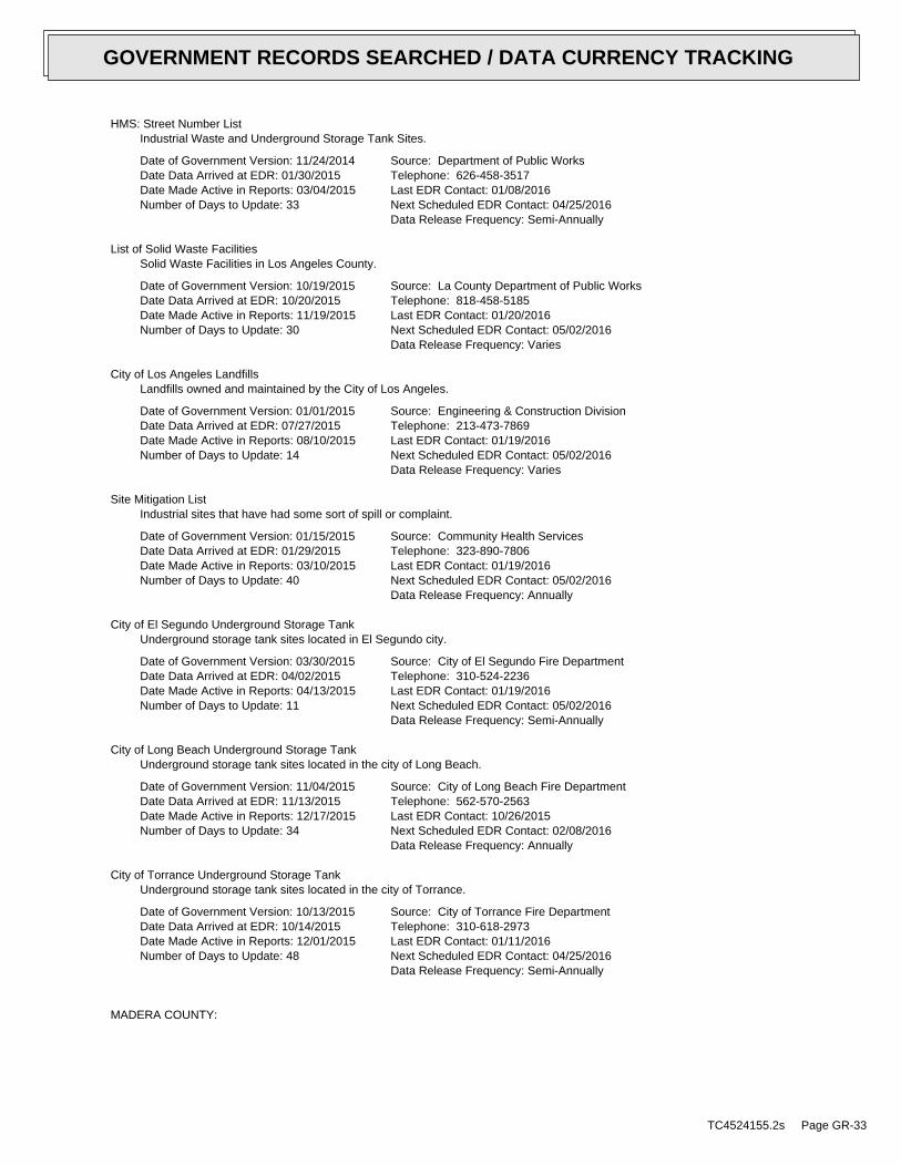
HMS: Street Number ListIndustrial Waste and Underground Storage Tank Sites.
Date of Government Version: 11/24/2014Date Data Arrived at EDR: 01/30/2015Date Made Active in Reports: 03/04/2015Number of Days to Update: 33
Source: Department of Public WorksTelephone: 626-458-3517Last EDR Contact: 01/08/2016Next Scheduled EDR Contact: 04/25/2016Data Release Frequency: Semi-Annually
List of Solid Waste FacilitiesSolid Waste Facilities in Los Angeles County.
Date of Government Version: 10/19/2015Date Data Arrived at EDR: 10/20/2015Date Made Active in Reports: 11/19/2015Number of Days to Update: 30
Source: La County Department of Public WorksTelephone: 818-458-5185Last EDR Contact: 01/20/2016Next Scheduled EDR Contact: 05/02/2016Data Release Frequency: Varies
City of Los Angeles LandfillsLandfills owned and maintained by the City of Los Angeles.
Date of Government Version: 01/01/2015Date Data Arrived at EDR: 07/27/2015Date Made Active in Reports: 08/10/2015Number of Days to Update: 14
Source: Engineering & Construction DivisionTelephone: 213-473-7869Last EDR Contact: 01/19/2016Next Scheduled EDR Contact: 05/02/2016Data Release Frequency: Varies
Site Mitigation ListIndustrial sites that have had some sort of spill or complaint.
Date of Government Version: 01/15/2015Date Data Arrived at EDR: 01/29/2015Date Made Active in Reports: 03/10/2015Number of Days to Update: 40
Source: Community Health ServicesTelephone: 323-890-7806Last EDR Contact: 01/19/2016Next Scheduled EDR Contact: 05/02/2016Data Release Frequency: Annually
City of El Segundo Underground Storage TankUnderground storage tank sites located in El Segundo city.
Date of Government Version: 03/30/2015Date Data Arrived at EDR: 04/02/2015Date Made Active in Reports: 04/13/2015Number of Days to Update: 11
Source: City of El Segundo Fire DepartmentTelephone: 310-524-2236Last EDR Contact: 01/19/2016Next Scheduled EDR Contact: 05/02/2016Data Release Frequency: Semi-Annually
City of Long Beach Underground Storage TankUnderground storage tank sites located in the city of Long Beach.
Date of Government Version: 11/04/2015Date Data Arrived at EDR: 11/13/2015Date Made Active in Reports: 12/17/2015Number of Days to Update: 34
Source: City of Long Beach Fire DepartmentTelephone: 562-570-2563Last EDR Contact: 10/26/2015Next Scheduled EDR Contact: 02/08/2016Data Release Frequency: Annually
City of Torrance Underground Storage TankUnderground storage tank sites located in the city of Torrance.
Date of Government Version: 10/13/2015Date Data Arrived at EDR: 10/14/2015Date Made Active in Reports: 12/01/2015Number of Days to Update: 48
Source: City of Torrance Fire DepartmentTelephone: 310-618-2973Last EDR Contact: 01/11/2016Next Scheduled EDR Contact: 04/25/2016Data Release Frequency: Semi-Annually
MADERA COUNTY:
TC4524155.2s Page GR-33
GOVERNMENT RECORDS SEARCHED / DATA CURRENCY TRACKING
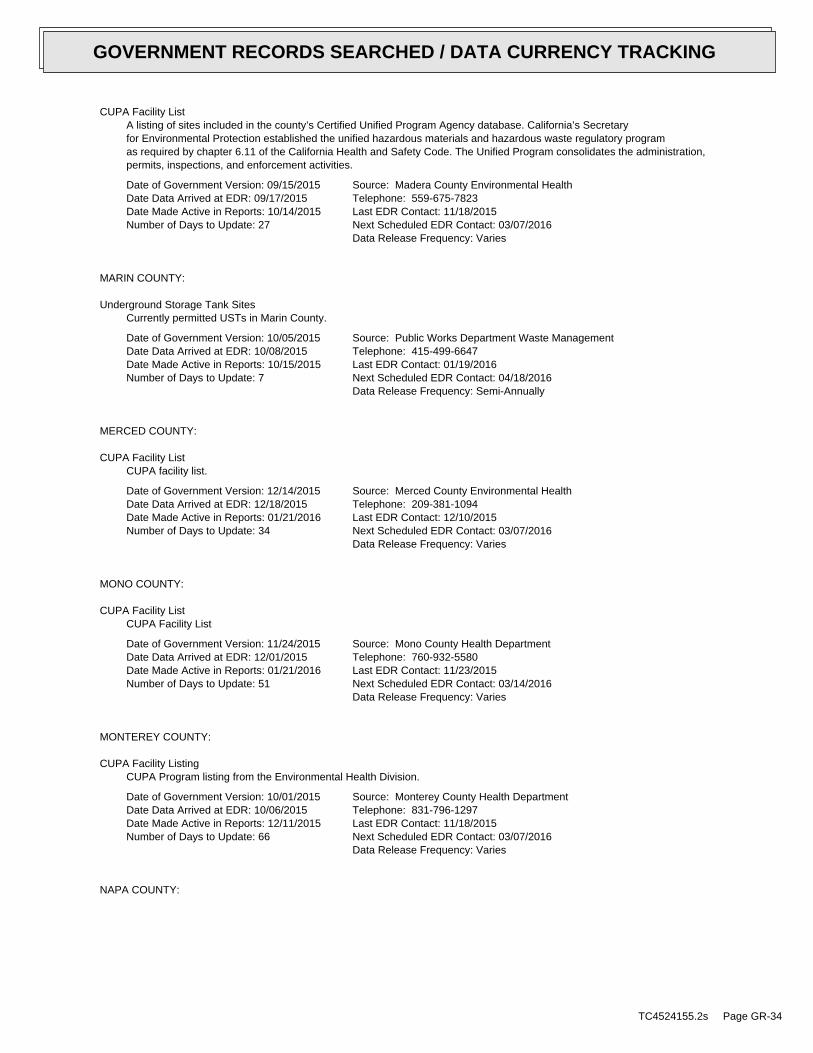
CUPA Facility ListA listing of sites included in the county’s Certified Unified Program Agency database. California’s Secretaryfor Environmental Protection established the unified hazardous materials and hazardous waste regulatory programas required by chapter 6.11 of the California Health and Safety Code. The Unified Program consolidates the administration,permits, inspections, and enforcement activities.
Date of Government Version: 09/15/2015Date Data Arrived at EDR: 09/17/2015Date Made Active in Reports: 10/14/2015Number of Days to Update: 27
Source: Madera County Environmental HealthTelephone: 559-675-7823Last EDR Contact: 11/18/2015Next Scheduled EDR Contact: 03/07/2016Data Release Frequency: Varies
MARIN COUNTY:
Underground Storage Tank SitesCurrently permitted USTs in Marin County.
Date of Government Version: 10/05/2015Date Data Arrived at EDR: 10/08/2015Date Made Active in Reports: 10/15/2015Number of Days to Update: 7
Source: Public Works Department Waste ManagementTelephone: 415-499-6647Last EDR Contact: 01/19/2016Next Scheduled EDR Contact: 04/18/2016Data Release Frequency: Semi-Annually
MERCED COUNTY:
CUPA Facility ListCUPA facility list.
Date of Government Version: 12/14/2015Date Data Arrived at EDR: 12/18/2015Date Made Active in Reports: 01/21/2016Number of Days to Update: 34
Source: Merced County Environmental HealthTelephone: 209-381-1094Last EDR Contact: 12/10/2015Next Scheduled EDR Contact: 03/07/2016Data Release Frequency: Varies
MONO COUNTY:
CUPA Facility ListCUPA Facility List
Date of Government Version: 11/24/2015Date Data Arrived at EDR: 12/01/2015Date Made Active in Reports: 01/21/2016Number of Days to Update: 51
Source: Mono County Health DepartmentTelephone: 760-932-5580Last EDR Contact: 11/23/2015Next Scheduled EDR Contact: 03/14/2016Data Release Frequency: Varies
MONTEREY COUNTY:
CUPA Facility ListingCUPA Program listing from the Environmental Health Division.
Date of Government Version: 10/01/2015Date Data Arrived at EDR: 10/06/2015Date Made Active in Reports: 12/11/2015Number of Days to Update: 66
Source: Monterey County Health DepartmentTelephone: 831-796-1297Last EDR Contact: 11/18/2015Next Scheduled EDR Contact: 03/07/2016Data Release Frequency: Varies
NAPA COUNTY:
TC4524155.2s Page GR-34
GOVERNMENT RECORDS SEARCHED / DATA CURRENCY TRACKING

Sites With Reported ContaminationA listing of leaking underground storage tank sites located in Napa county.
Date of Government Version: 12/05/2011Date Data Arrived at EDR: 12/06/2011Date Made Active in Reports: 02/07/2012Number of Days to Update: 63
Source: Napa County Department of Environmental ManagementTelephone: 707-253-4269Last EDR Contact: 11/23/2015Next Scheduled EDR Contact: 03/14/2016Data Release Frequency: No Update Planned
Closed and Operating Underground Storage Tank SitesUnderground storage tank sites located in Napa county.
Date of Government Version: 01/15/2008Date Data Arrived at EDR: 01/16/2008Date Made Active in Reports: 02/08/2008Number of Days to Update: 23
Source: Napa County Department of Environmental ManagementTelephone: 707-253-4269Last EDR Contact: 11/23/2015Next Scheduled EDR Contact: 03/14/2016Data Release Frequency: No Update Planned
NEVADA COUNTY:
CUPA Facility ListCUPA facility list.
Date of Government Version: 11/16/2015Date Data Arrived at EDR: 11/17/2015Date Made Active in Reports: 12/11/2015Number of Days to Update: 24
Source: Community Development AgencyTelephone: 530-265-1467Last EDR Contact: 11/06/2015Next Scheduled EDR Contact: 02/15/2016Data Release Frequency: Varies
ORANGE COUNTY:
List of Industrial Site CleanupsPetroleum and non-petroleum spills.
Date of Government Version: 11/01/2015Date Data Arrived at EDR: 11/17/2015Date Made Active in Reports: 01/21/2016Number of Days to Update: 65
Source: Health Care AgencyTelephone: 714-834-3446Last EDR Contact: 11/10/2015Next Scheduled EDR Contact: 02/22/2016Data Release Frequency: Annually
List of Underground Storage Tank CleanupsOrange County Underground Storage Tank Cleanups (LUST).
Date of Government Version: 08/03/2015Date Data Arrived at EDR: 08/10/2015Date Made Active in Reports: 09/11/2015Number of Days to Update: 32
Source: Health Care AgencyTelephone: 714-834-3446Last EDR Contact: 11/10/2015Next Scheduled EDR Contact: 02/22/2016Data Release Frequency: Quarterly
List of Underground Storage Tank FacilitiesOrange County Underground Storage Tank Facilities (UST).
Date of Government Version: 11/01/2015Date Data Arrived at EDR: 11/11/2015Date Made Active in Reports: 12/17/2015Number of Days to Update: 36
Source: Health Care AgencyTelephone: 714-834-3446Last EDR Contact: 11/11/2015Next Scheduled EDR Contact: 02/22/2016Data Release Frequency: Quarterly
PLACER COUNTY:
TC4524155.2s Page GR-35
GOVERNMENT RECORDS SEARCHED / DATA CURRENCY TRACKING

Master List of FacilitiesList includes aboveground tanks, underground tanks and cleanup sites.
Date of Government Version: 12/09/2015Date Data Arrived at EDR: 12/11/2015Date Made Active in Reports: 01/21/2016Number of Days to Update: 41
Source: Placer County Health and Human ServicesTelephone: 530-745-2363Last EDR Contact: 12/04/2015Next Scheduled EDR Contact: 03/21/2016Data Release Frequency: Semi-Annually
RIVERSIDE COUNTY:
Listing of Underground Tank Cleanup SitesRiverside County Underground Storage Tank Cleanup Sites (LUST).
Date of Government Version: 10/26/2015Date Data Arrived at EDR: 10/28/2015Date Made Active in Reports: 11/19/2015Number of Days to Update: 22
Source: Department of Environmental HealthTelephone: 951-358-5055Last EDR Contact: 12/17/2015Next Scheduled EDR Contact: 04/04/2016Data Release Frequency: Quarterly
Underground Storage Tank Tank ListUnderground storage tank sites located in Riverside county.
Date of Government Version: 10/26/2015Date Data Arrived at EDR: 10/28/2015Date Made Active in Reports: 11/19/2015Number of Days to Update: 22
Source: Department of Environmental HealthTelephone: 951-358-5055Last EDR Contact: 12/17/2015Next Scheduled EDR Contact: 04/04/2016Data Release Frequency: Quarterly
SACRAMENTO COUNTY:
Toxic Site Clean-Up ListList of sites where unauthorized releases of potentially hazardous materials have occurred.
Date of Government Version: 08/03/2015Date Data Arrived at EDR: 10/06/2015Date Made Active in Reports: 11/16/2015Number of Days to Update: 41
Source: Sacramento County Environmental ManagementTelephone: 916-875-8406Last EDR Contact: 01/05/2016Next Scheduled EDR Contact: 04/18/2016Data Release Frequency: Quarterly
Master Hazardous Materials Facility ListAny business that has hazardous materials on site - hazardous material storage sites, underground storage tanks,waste generators.
Date of Government Version: 08/03/2015Date Data Arrived at EDR: 10/06/2015Date Made Active in Reports: 11/06/2015Number of Days to Update: 31
Source: Sacramento County Environmental ManagementTelephone: 916-875-8406Last EDR Contact: 01/05/2016Next Scheduled EDR Contact: 04/18/2016Data Release Frequency: Quarterly
SAN BERNARDINO COUNTY:
Hazardous Material PermitsThis listing includes underground storage tanks, medical waste handlers/generators, hazardous materials handlers,hazardous waste generators, and waste oil generators/handlers.
TC4524155.2s Page GR-36
GOVERNMENT RECORDS SEARCHED / DATA CURRENCY TRACKING

Date of Government Version: 06/30/2015Date Data Arrived at EDR: 07/07/2015Date Made Active in Reports: 07/14/2015Number of Days to Update: 7
Source: San Bernardino County Fire Department Hazardous Materials DivisionTelephone: 909-387-3041Last EDR Contact: 11/09/2015Next Scheduled EDR Contact: 02/22/2016Data Release Frequency: Quarterly
SAN DIEGO COUNTY:
Hazardous Materials Management Division DatabaseThe database includes: HE58 - This report contains the business name, site address, business phone number, establishment’H’ permit number, type of permit, and the business status. HE17 - In addition to providing the same informationprovided in the HE58 listing, HE17 provides inspection dates, violations received by the establishment, hazardouswaste generated, the quantity, method of storage, treatment/disposal of waste and the hauler, and informationon underground storage tanks. Unauthorized Release List - Includes a summary of environmental contamination casesin San Diego County (underground tank cases, non-tank cases, groundwater contamination, and soil contaminationare included.)
Date of Government Version: 09/23/2013Date Data Arrived at EDR: 09/24/2013Date Made Active in Reports: 10/17/2013Number of Days to Update: 23
Source: Hazardous Materials Management DivisionTelephone: 619-338-2268Last EDR Contact: 12/04/2015Next Scheduled EDR Contact: 03/21/2016Data Release Frequency: Quarterly
Solid Waste FacilitiesSan Diego County Solid Waste Facilities.
Date of Government Version: 10/31/2015Date Data Arrived at EDR: 11/07/2015Date Made Active in Reports: 01/04/2016Number of Days to Update: 58
Source: Department of Health ServicesTelephone: 619-338-2209Last EDR Contact: 10/26/2015Next Scheduled EDR Contact: 02/08/2016Data Release Frequency: Varies
Environmental Case ListingThe listing contains all underground tank release cases and projects pertaining to properties contaminated withhazardous substances that are actively under review by the Site Assessment and Mitigation Program.
Date of Government Version: 03/23/2010Date Data Arrived at EDR: 06/15/2010Date Made Active in Reports: 07/09/2010Number of Days to Update: 24
Source: San Diego County Department of Environmental HealthTelephone: 619-338-2371Last EDR Contact: 12/04/2015Next Scheduled EDR Contact: 03/21/2016Data Release Frequency: No Update Planned
SAN FRANCISCO COUNTY:
Local Oversite FacilitiesA listing of leaking underground storage tank sites located in San Francisco county.
Date of Government Version: 09/19/2008Date Data Arrived at EDR: 09/19/2008Date Made Active in Reports: 09/29/2008Number of Days to Update: 10
Source: Department Of Public Health San Francisco CountyTelephone: 415-252-3920Last EDR Contact: 11/09/2015Next Scheduled EDR Contact: 02/22/2016Data Release Frequency: Quarterly
Underground Storage Tank InformationUnderground storage tank sites located in San Francisco county.
Date of Government Version: 11/29/2010Date Data Arrived at EDR: 03/10/2011Date Made Active in Reports: 03/15/2011Number of Days to Update: 5
Source: Department of Public HealthTelephone: 415-252-3920Last EDR Contact: 11/09/2015Next Scheduled EDR Contact: 02/22/2016Data Release Frequency: Quarterly
SAN JOAQUIN COUNTY:
TC4524155.2s Page GR-37
GOVERNMENT RECORDS SEARCHED / DATA CURRENCY TRACKING

San Joaquin Co. USTA listing of underground storage tank locations in San Joaquin county.
Date of Government Version: 09/23/2015Date Data Arrived at EDR: 09/25/2015Date Made Active in Reports: 10/15/2015Number of Days to Update: 20
Source: Environmental Health DepartmentTelephone: N/ALast EDR Contact: 12/17/2015Next Scheduled EDR Contact: 04/04/2016Data Release Frequency: Semi-Annually
SAN LUIS OBISPO COUNTY:
CUPA Facility ListCupa Facility List.
Date of Government Version: 12/07/2015Date Data Arrived at EDR: 12/10/2015Date Made Active in Reports: 01/21/2016Number of Days to Update: 42
Source: San Luis Obispo County Public Health DepartmentTelephone: 805-781-5596Last EDR Contact: 12/04/2015Next Scheduled EDR Contact: 03/07/2016Data Release Frequency: Varies
SAN MATEO COUNTY:
Business InventoryList includes Hazardous Materials Business Plan, hazardous waste generators, and underground storage tanks.
Date of Government Version: 10/14/2015Date Data Arrived at EDR: 10/15/2015Date Made Active in Reports: 11/16/2015Number of Days to Update: 32
Source: San Mateo County Environmental Health Services DivisionTelephone: 650-363-1921Last EDR Contact: 12/14/2015Next Scheduled EDR Contact: 03/28/2016Data Release Frequency: Annually
Fuel Leak ListA listing of leaking underground storage tank sites located in San Mateo county.
Date of Government Version: 09/16/2015Date Data Arrived at EDR: 09/17/2015Date Made Active in Reports: 11/05/2015Number of Days to Update: 49
Source: San Mateo County Environmental Health Services DivisionTelephone: 650-363-1921Last EDR Contact: 12/10/2015Next Scheduled EDR Contact: 03/28/2016Data Release Frequency: Semi-Annually
SANTA BARBARA COUNTY:
CUPA Facility ListingCUPA Program Listing from the Environmental Health Services division.
Date of Government Version: 09/08/2011Date Data Arrived at EDR: 09/09/2011Date Made Active in Reports: 10/07/2011Number of Days to Update: 28
Source: Santa Barbara County Public Health DepartmentTelephone: 805-686-8167Last EDR Contact: 11/18/2015Next Scheduled EDR Contact: 03/07/2016Data Release Frequency: Varies
SANTA CLARA COUNTY:
Cupa Facility ListCupa facility list
TC4524155.2s Page GR-38
GOVERNMENT RECORDS SEARCHED / DATA CURRENCY TRACKING

Date of Government Version: 11/18/2015Date Data Arrived at EDR: 11/24/2015Date Made Active in Reports: 12/11/2015Number of Days to Update: 17
Source: Department of Environmental HealthTelephone: 408-918-1973Last EDR Contact: 11/18/2015Next Scheduled EDR Contact: 03/07/2016Data Release Frequency: Varies
HIST LUST - Fuel Leak Site Activity ReportA listing of open and closed leaking underground storage tanks. This listing is no longer updated by the county.Leaking underground storage tanks are now handled by the Department of Environmental Health.
Date of Government Version: 03/29/2005Date Data Arrived at EDR: 03/30/2005Date Made Active in Reports: 04/21/2005Number of Days to Update: 22
Source: Santa Clara Valley Water DistrictTelephone: 408-265-2600Last EDR Contact: 03/23/2009Next Scheduled EDR Contact: 06/22/2009Data Release Frequency: No Update Planned
LOP ListingA listing of leaking underground storage tanks located in Santa Clara county.
Date of Government Version: 03/03/2014Date Data Arrived at EDR: 03/05/2014Date Made Active in Reports: 03/18/2014Number of Days to Update: 13
Source: Department of Environmental HealthTelephone: 408-918-3417Last EDR Contact: 11/23/2015Next Scheduled EDR Contact: 03/14/2016Data Release Frequency: Annually
Hazardous Material FacilitiesHazardous material facilities, including underground storage tank sites.
Date of Government Version: 11/17/2015Date Data Arrived at EDR: 11/23/2015Date Made Active in Reports: 01/21/2016Number of Days to Update: 59
Source: City of San Jose Fire DepartmentTelephone: 408-535-7694Last EDR Contact: 11/18/2015Next Scheduled EDR Contact: 02/22/2016Data Release Frequency: Annually
SANTA CRUZ COUNTY:
CUPA Facility ListCUPA facility listing.
Date of Government Version: 11/18/2015Date Data Arrived at EDR: 11/23/2015Date Made Active in Reports: 12/11/2015Number of Days to Update: 18
Source: Santa Cruz County Environmental HealthTelephone: 831-464-2761Last EDR Contact: 11/18/2015Next Scheduled EDR Contact: 03/07/2016Data Release Frequency: Varies
SHASTA COUNTY:
CUPA Facility ListCupa Facility List.
Date of Government Version: 12/09/2015Date Data Arrived at EDR: 12/10/2015Date Made Active in Reports: 01/21/2016Number of Days to Update: 42
Source: Shasta County Department of Resource ManagementTelephone: 530-225-5789Last EDR Contact: 11/18/2015Next Scheduled EDR Contact: 03/07/2016Data Release Frequency: Varies
SOLANO COUNTY:
TC4524155.2s Page GR-39
GOVERNMENT RECORDS SEARCHED / DATA CURRENCY TRACKING

Leaking Underground Storage TanksA listing of leaking underground storage tank sites located in Solano county.
Date of Government Version: 09/02/2015Date Data Arrived at EDR: 09/17/2015Date Made Active in Reports: 11/05/2015Number of Days to Update: 49
Source: Solano County Department of Environmental ManagementTelephone: 707-784-6770Last EDR Contact: 09/10/2015Next Scheduled EDR Contact: 12/28/2015Data Release Frequency: Quarterly
Underground Storage TanksUnderground storage tank sites located in Solano county.
Date of Government Version: 09/02/2015Date Data Arrived at EDR: 09/18/2015Date Made Active in Reports: 10/15/2015Number of Days to Update: 27
Source: Solano County Department of Environmental ManagementTelephone: 707-784-6770Last EDR Contact: 12/10/2015Next Scheduled EDR Contact: 03/28/2016Data Release Frequency: Quarterly
SONOMA COUNTY:
Cupa Facility ListCupa Facility list
Date of Government Version: 09/28/2015Date Data Arrived at EDR: 09/30/2015Date Made Active in Reports: 11/05/2015Number of Days to Update: 36
Source: County of Sonoma Fire & Emergency Services DepartmentTelephone: 707-565-1174Last EDR Contact: 01/11/2016Next Scheduled EDR Contact: 04/11/2016Data Release Frequency: Varies
Leaking Underground Storage Tank SitesA listing of leaking underground storage tank sites located in Sonoma county.
Date of Government Version: 10/01/2015Date Data Arrived at EDR: 10/02/2015Date Made Active in Reports: 11/05/2015Number of Days to Update: 34
Source: Department of Health ServicesTelephone: 707-565-6565Last EDR Contact: 12/23/2015Next Scheduled EDR Contact: 04/11/2016Data Release Frequency: Quarterly
SUTTER COUNTY:
Underground Storage TanksUnderground storage tank sites located in Sutter county.
Date of Government Version: 12/07/2015Date Data Arrived at EDR: 12/08/2015Date Made Active in Reports: 12/17/2015Number of Days to Update: 9
Source: Sutter County Department of AgricultureTelephone: 530-822-7500Last EDR Contact: 12/04/2015Next Scheduled EDR Contact: 03/21/2016Data Release Frequency: Semi-Annually
TUOLUMNE COUNTY:
CUPA Facility ListCupa facility list
Date of Government Version: 10/29/2015Date Data Arrived at EDR: 10/30/2015Date Made Active in Reports: 12/11/2015Number of Days to Update: 42
Source: Divison of Environmental HealthTelephone: 209-533-5633Last EDR Contact: 10/26/2015Next Scheduled EDR Contact: 02/08/2016Data Release Frequency: Varies
VENTURA COUNTY:
TC4524155.2s Page GR-40
GOVERNMENT RECORDS SEARCHED / DATA CURRENCY TRACKING

Business Plan, Hazardous Waste Producers, and Operating Underground TanksThe BWT list indicates by site address whether the Environmental Health Division has Business Plan (B), WasteProducer (W), and/or Underground Tank (T) information.
Date of Government Version: 07/27/2015Date Data Arrived at EDR: 08/17/2015Date Made Active in Reports: 09/03/2015Number of Days to Update: 17
Source: Ventura County Environmental Health DivisionTelephone: 805-654-2813Last EDR Contact: 08/12/2015Next Scheduled EDR Contact: 11/30/2015Data Release Frequency: Quarterly
Inventory of Illegal Abandoned and Inactive SitesVentura County Inventory of Closed, Illegal Abandoned, and Inactive Sites.
Date of Government Version: 12/01/2011Date Data Arrived at EDR: 12/01/2011Date Made Active in Reports: 01/19/2012Number of Days to Update: 49
Source: Environmental Health DivisionTelephone: 805-654-2813Last EDR Contact: 12/30/2015Next Scheduled EDR Contact: 04/18/2016Data Release Frequency: Annually
Listing of Underground Tank Cleanup SitesVentura County Underground Storage Tank Cleanup Sites (LUST).
Date of Government Version: 05/29/2008Date Data Arrived at EDR: 06/24/2008Date Made Active in Reports: 07/31/2008Number of Days to Update: 37
Source: Environmental Health DivisionTelephone: 805-654-2813Last EDR Contact: 11/13/2015Next Scheduled EDR Contact: 02/29/2016Data Release Frequency: Quarterly
Medical Waste Program ListTo protect public health and safety and the environment from potential exposure to disease causing agents, theEnvironmental Health Division Medical Waste Program regulates the generation, handling, storage, treatment anddisposal of medical waste throughout the County.
Date of Government Version: 09/28/2015Date Data Arrived at EDR: 10/28/2015Date Made Active in Reports: 11/19/2015Number of Days to Update: 22
Source: Ventura County Resource Management AgencyTelephone: 805-654-2813Last EDR Contact: 10/26/2015Next Scheduled EDR Contact: 02/08/2016Data Release Frequency: Quarterly
Underground Tank Closed Sites ListVentura County Operating Underground Storage Tank Sites (UST)/Underground Tank Closed Sites List.
Date of Government Version: 08/26/2015Date Data Arrived at EDR: 09/15/2015Date Made Active in Reports: 10/15/2015Number of Days to Update: 30
Source: Environmental Health DivisionTelephone: 805-654-2813Last EDR Contact: 12/17/2015Next Scheduled EDR Contact: 03/28/2016Data Release Frequency: Quarterly
YOLO COUNTY:
Underground Storage Tank Comprehensive Facility ReportUnderground storage tank sites located in Yolo county.
Date of Government Version: 10/19/2015Date Data Arrived at EDR: 10/27/2015Date Made Active in Reports: 11/19/2015Number of Days to Update: 23
Source: Yolo County Department of HealthTelephone: 530-666-8646Last EDR Contact: 01/19/2016Next Scheduled EDR Contact: 04/18/2016Data Release Frequency: Annually
YUBA COUNTY:
TC4524155.2s Page GR-41
GOVERNMENT RECORDS SEARCHED / DATA CURRENCY TRACKING

CUPA Facility ListCUPA facility listing for Yuba County.
Date of Government Version: 11/13/2015Date Data Arrived at EDR: 11/17/2015Date Made Active in Reports: 12/11/2015Number of Days to Update: 24
Source: Yuba County Environmental Health DepartmentTelephone: 530-749-7523Last EDR Contact: 11/13/2015Next Scheduled EDR Contact: 02/15/2016Data Release Frequency: Varies
OTHER DATABASE(S)
Depending on the geographic area covered by this report, the data provided in these specialty databases may or may not becomplete. For example, the existence of wetlands information data in a specific report does not mean that all wetlands in thearea covered by the report are included. Moreover, the absence of any reported wetlands information does not necessarilymean that wetlands do not exist in the area covered by the report.
CT MANIFEST: Hazardous Waste Manifest DataFacility and manifest data. Manifest is a document that lists and tracks hazardous waste from the generator throughtransporters to a tsd facility.
Date of Government Version: 07/30/2013Date Data Arrived at EDR: 08/19/2013Date Made Active in Reports: 10/03/2013Number of Days to Update: 45
Source: Department of Energy & Environmental ProtectionTelephone: 860-424-3375Last EDR Contact: 11/16/2015Next Scheduled EDR Contact: 02/29/2016Data Release Frequency: No Update Planned
NJ MANIFEST: Manifest InformationHazardous waste manifest information.
Date of Government Version: 12/31/2013Date Data Arrived at EDR: 07/17/2015Date Made Active in Reports: 08/12/2015Number of Days to Update: 26
Source: Department of Environmental ProtectionTelephone: N/ALast EDR Contact: 01/15/2016Next Scheduled EDR Contact: 04/25/2016Data Release Frequency: Annually
NY MANIFEST: Facility and Manifest DataManifest is a document that lists and tracks hazardous waste from the generator through transporters to a TSDfacility.
Date of Government Version: 11/02/2015Date Data Arrived at EDR: 11/08/2015Date Made Active in Reports: 12/09/2015Number of Days to Update: 31
Source: Department of Environmental ConservationTelephone: 518-402-8651Last EDR Contact: 11/08/2015Next Scheduled EDR Contact: 02/15/2016Data Release Frequency: Annually
PA MANIFEST: Manifest InformationHazardous waste manifest information.
Date of Government Version: 12/31/2014Date Data Arrived at EDR: 07/24/2015Date Made Active in Reports: 08/18/2015Number of Days to Update: 25
Source: Department of Environmental ProtectionTelephone: 717-783-8990Last EDR Contact: 01/19/2016Next Scheduled EDR Contact: 05/02/2016Data Release Frequency: Annually
RI MANIFEST: Manifest informationHazardous waste manifest information
Date of Government Version: 12/31/2013Date Data Arrived at EDR: 06/19/2015Date Made Active in Reports: 07/15/2015Number of Days to Update: 26
Source: Department of Environmental ManagementTelephone: 401-222-2797Last EDR Contact: 11/19/2015Next Scheduled EDR Contact: 03/07/2016Data Release Frequency: Annually
TC4524155.2s Page GR-42
GOVERNMENT RECORDS SEARCHED / DATA CURRENCY TRACKING
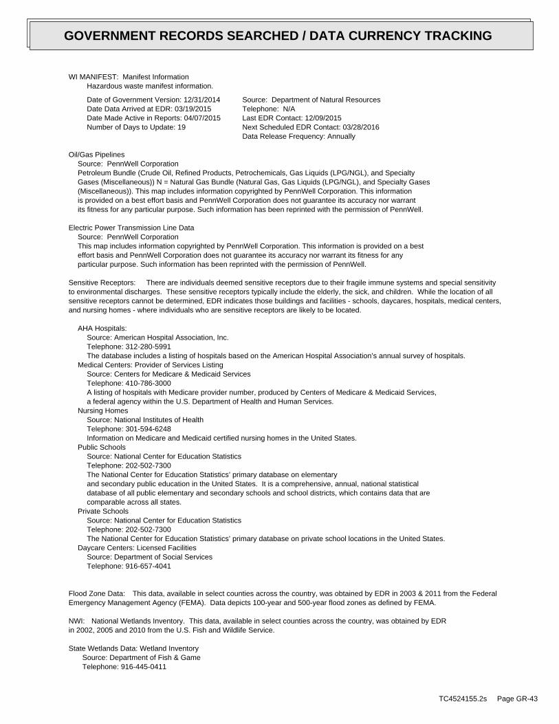
WI MANIFEST: Manifest InformationHazardous waste manifest information.
Date of Government Version: 12/31/2014Date Data Arrived at EDR: 03/19/2015Date Made Active in Reports: 04/07/2015Number of Days to Update: 19
Source: Department of Natural ResourcesTelephone: N/ALast EDR Contact: 12/09/2015Next Scheduled EDR Contact: 03/28/2016Data Release Frequency: Annually
Oil/Gas PipelinesSource: PennWell CorporationPetroleum Bundle (Crude Oil, Refined Products, Petrochemicals, Gas Liquids (LPG/NGL), and SpecialtyGases (Miscellaneous)) N = Natural Gas Bundle (Natural Gas, Gas Liquids (LPG/NGL), and Specialty Gases(Miscellaneous)). This map includes information copyrighted by PennWell Corporation. This informationis provided on a best effort basis and PennWell Corporation does not guarantee its accuracy nor warrantits fitness for any particular purpose. Such information has been reprinted with the permission of PennWell.
Electric Power Transmission Line DataSource: PennWell CorporationThis map includes information copyrighted by PennWell Corporation. This information is provided on a besteffort basis and PennWell Corporation does not guarantee its accuracy nor warrant its fitness for anyparticular purpose. Such information has been reprinted with the permission of PennWell.
Sensitive Receptors: There are individuals deemed sensitive receptors due to their fragile immune systems and special sensitivityto environmental discharges. These sensitive receptors typically include the elderly, the sick, and children. While the location of allsensitive receptors cannot be determined, EDR indicates those buildings and facilities - schools, daycares, hospitals, medical centers,and nursing homes - where individuals who are sensitive receptors are likely to be located.
AHA Hospitals:Source: American Hospital Association, Inc.Telephone: 312-280-5991The database includes a listing of hospitals based on the American Hospital Association’s annual survey of hospitals.
Medical Centers: Provider of Services ListingSource: Centers for Medicare & Medicaid ServicesTelephone: 410-786-3000A listing of hospitals with Medicare provider number, produced by Centers of Medicare & Medicaid Services,a federal agency within the U.S. Department of Health and Human Services.
Nursing HomesSource: National Institutes of HealthTelephone: 301-594-6248Information on Medicare and Medicaid certified nursing homes in the United States.
Public SchoolsSource: National Center for Education StatisticsTelephone: 202-502-7300The National Center for Education Statistics’ primary database on elementaryand secondary public education in the United States. It is a comprehensive, annual, national statisticaldatabase of all public elementary and secondary schools and school districts, which contains data that arecomparable across all states.
Private SchoolsSource: National Center for Education StatisticsTelephone: 202-502-7300The National Center for Education Statistics’ primary database on private school locations in the United States.
Daycare Centers: Licensed FacilitiesSource: Department of Social ServicesTelephone: 916-657-4041
Flood Zone Data: This data, available in select counties across the country, was obtained by EDR in 2003 & 2011 from the FederalEmergency Management Agency (FEMA). Data depicts 100-year and 500-year flood zones as defined by FEMA.
NWI: National Wetlands Inventory. This data, available in select counties across the country, was obtained by EDRin 2002, 2005 and 2010 from the U.S. Fish and Wildlife Service.
State Wetlands Data: Wetland InventorySource: Department of Fish & GameTelephone: 916-445-0411
TC4524155.2s Page GR-43
GOVERNMENT RECORDS SEARCHED / DATA CURRENCY TRACKING

Current USGS 7.5 Minute Topographic MapSource: U.S. Geological Survey
STREET AND ADDRESS INFORMATION
© 2015 TomTom North America, Inc. All rights reserved. This material is proprietary and the subject of copyright protectionand other intellectual property rights owned by or licensed to Tele Atlas North America, Inc. The use of this material is subjectto the terms of a license agreement. You will be held liable for any unauthorized copying or disclosure of this material.
TC4524155.2s Page GR-44
GOVERNMENT RECORDS SEARCHED / DATA CURRENCY TRACKING
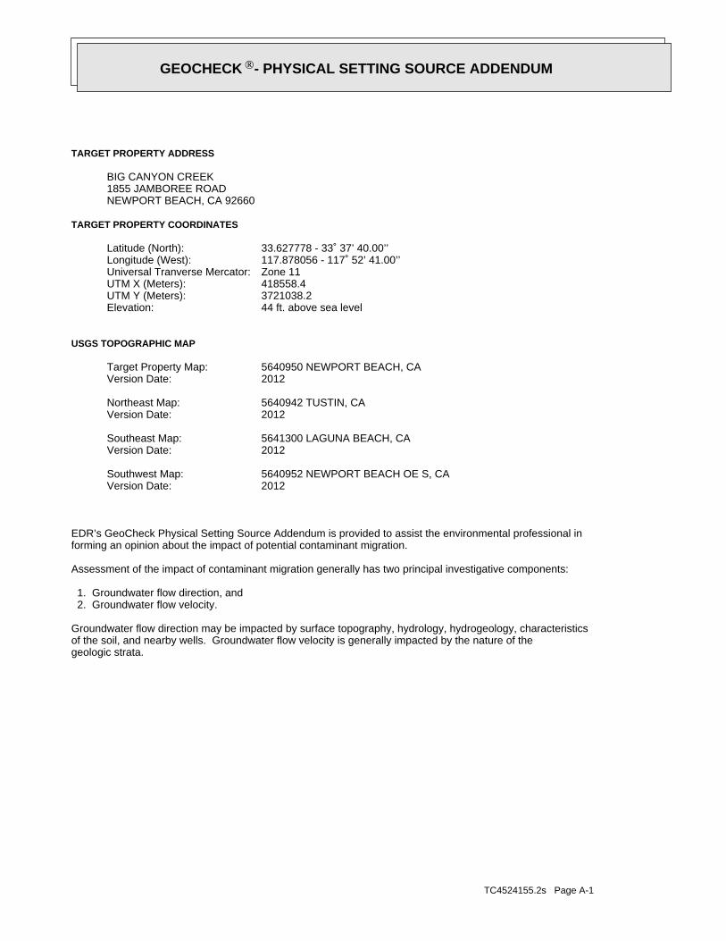
TC4524155.2s Page A-1
geologic strata.of the soil, and nearby wells. Groundwater flow velocity is generally impacted by the nature of theGroundwater flow direction may be impacted by surface topography, hydrology, hydrogeology, characteristics
2. Groundwater flow velocity. 1. Groundwater flow direction, and
Assessment of the impact of contaminant migration generally has two principal investigative components:
forming an opinion about the impact of potential contaminant migration.EDR’s GeoCheck Physical Setting Source Addendum is provided to assist the environmental professional in
2012Version Date:5640952 NEWPORT BEACH OE S, CASouthwest Map:
2012Version Date:5641300 LAGUNA BEACH, CASoutheast Map:
2012Version Date:5640942 TUSTIN, CANortheast Map:
2012Version Date:5640950 NEWPORT BEACH, CATarget Property Map:
USGS TOPOGRAPHIC MAP
44 ft. above sea levelElevation:3721038.2UTM Y (Meters): 418558.4UTM X (Meters): Zone 11Universal Tranverse Mercator: 117.878056 - 117˚ 52’ 41.00’’Longitude (West): 33.627778 - 33˚ 37’ 40.00’’Latitude (North):
TARGET PROPERTY COORDINATES
NEWPORT BEACH, CA 926601855 JAMBOREE ROADBIG CANYON CREEK
TARGET PROPERTY ADDRESS
®GEOCHECK - PHYSICAL SETTING SOURCE ADDENDUM®

TC4524155.2s Page A-2
should be field verified.on a relative (not an absolute) basis. Relative elevation information between sites of close proximitySource: Topography has been determined from the USGS 7.5’ Digital Elevation Model and should be evaluated
SURROUNDING TOPOGRAPHY: ELEVATION PROFILES
Ele
vatio
n (f
t)E
leva
tion
(ft)
TP
TP0 1/2 1 Miles
✩Target Property Elevation: 44 ft.
North South
West East
131
165
170
181
189
188162134108
44
89
112
114
115
117
115
106
1039887
97
107
0 0 0 4
109
113
44
113 78
165
210
125
166
179
193
178
General WNWGeneral Topographic Gradient:TARGET PROPERTY TOPOGRAPHY
should contamination exist on the target property, what downgradient sites might be impacted.assist the environmental professional in forming an opinion about the impact of nearby contaminated properties or,Surface topography may be indicative of the direction of surficial groundwater flow. This information can be used toTOPOGRAPHIC INFORMATION
collected on nearby properties, and regional groundwater flow information (from deep aquifers).sources of information, such as surface topographic information, hydrologic information, hydrogeologic datausing site-specific well data. If such data is not reasonably ascertainable, it may be necessary to rely on otherGroundwater flow direction for a particular site is best determined by a qualified environmental professionalGROUNDWATER FLOW DIRECTION INFORMATION
®GEOCHECK - PHYSICAL SETTING SOURCE SUMMARY®

TC4524155.2s Page A-3
For additional site information, refer to Physical Setting Source Map Findings.
NW1/4 - 1/2 Mile SSW2NE1/8 - 1/4 Mile SSW1
GENERAL DIRECTIONLOCATIONGROUNDWATER FLOWFROM TPMAP ID
hydrogeologically, and the depth to water table.authorities at select sites and has extracted the date of the report, groundwater flow direction as determinedflow at specific points. EDR has reviewed reports submitted by environmental professionals to regulatoryEDR has developed the AQUIFLOW Information System to provide data on the general direction of groundwater
AQUIFLOW®
Search Radius: 1.000 Mile.
Not found Status:1.25 miles Search Radius:
Site-Specific Hydrogeological Data*:
* ©1996 Site−specific hydrogeological data gathered by CERCLIS Alerts, Inc., Bainbridge Island, WA. All rights reserved. All of the information and opinions presented are those of the cited EPA report(s), which were completed undera Comprehensive Environmental Response Compensation and Liability Information System (CERCLIS) investigation.
contamination exist on the target property, what downgradient sites might be impacted.environmental professional in forming an opinion about the impact of nearby contaminated properties or, shouldof groundwater flow direction in the immediate area. Such hydrogeologic information can be used to assist theHydrogeologic information obtained by installation of wells on a specific site can often be an indicatorHYDROGEOLOGIC INFORMATION
YES - refer to the Overview Map and Detail MapCOSTA MESA
NATIONAL WETLAND INVENTORYNWI ElectronicData CoverageNWI Quad at Target Property
Not ReportedAdditional Panels in search area:
06059C - FEMA DFIRM Flood dataFlood Plain Panel at Target Property:
YES - refer to the Overview Map and Detail MapORANGE, CA
FEMA FLOOD ZONEFEMA FloodElectronic DataTarget Property County
and bodies of water).Refer to the Physical Setting Source Map following this summary for hydrologic information (major waterways
contamination exist on the target property, what downgradient sites might be impacted.the environmental professional in forming an opinion about the impact of nearby contaminated properties or, shouldSurface water can act as a hydrologic barrier to groundwater flow. Such hydrologic information can be used to assistHYDROLOGIC INFORMATION
®GEOCHECK - PHYSICAL SETTING SOURCE SUMMARY®
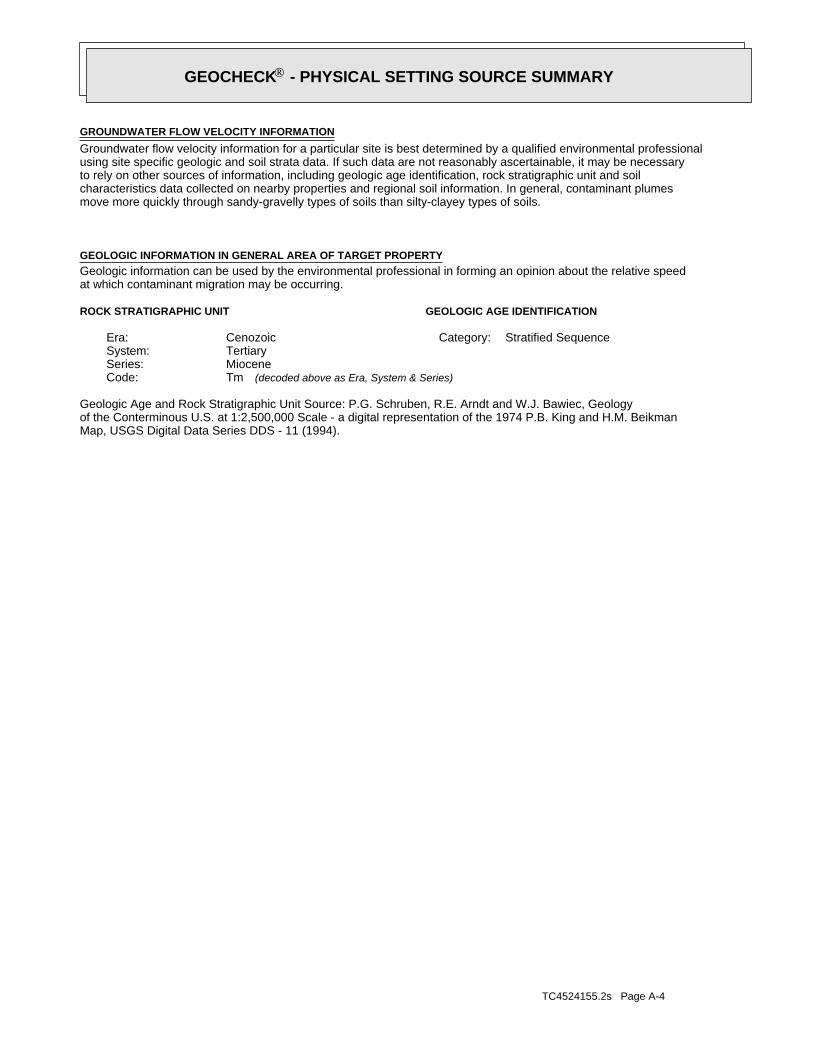
TC4524155.2s Page A-4
Map, USGS Digital Data Series DDS - 11 (1994).of the Conterminous U.S. at 1:2,500,000 Scale - a digital representation of the 1974 P.B. King and H.M. BeikmanGeologic Age and Rock Stratigraphic Unit Source: P.G. Schruben, R.E. Arndt and W.J. Bawiec, Geology
ROCK STRATIGRAPHIC UNIT GEOLOGIC AGE IDENTIFICATION
Stratified SequenceCategory:CenozoicEra:TertiarySystem:MioceneSeries:TmCode: (decoded above as Era, System & Series)
at which contaminant migration may be occurring.Geologic information can be used by the environmental professional in forming an opinion about the relative speedGEOLOGIC INFORMATION IN GENERAL AREA OF TARGET PROPERTY
move more quickly through sandy-gravelly types of soils than silty-clayey types of soils.characteristics data collected on nearby properties and regional soil information. In general, contaminant plumesto rely on other sources of information, including geologic age identification, rock stratigraphic unit and soilusing site specific geologic and soil strata data. If such data are not reasonably ascertainable, it may be necessaryGroundwater flow velocity information for a particular site is best determined by a qualified environmental professionalGROUNDWATER FLOW VELOCITY INFORMATION
®GEOCHECK - PHYSICAL SETTING SOURCE SUMMARY®
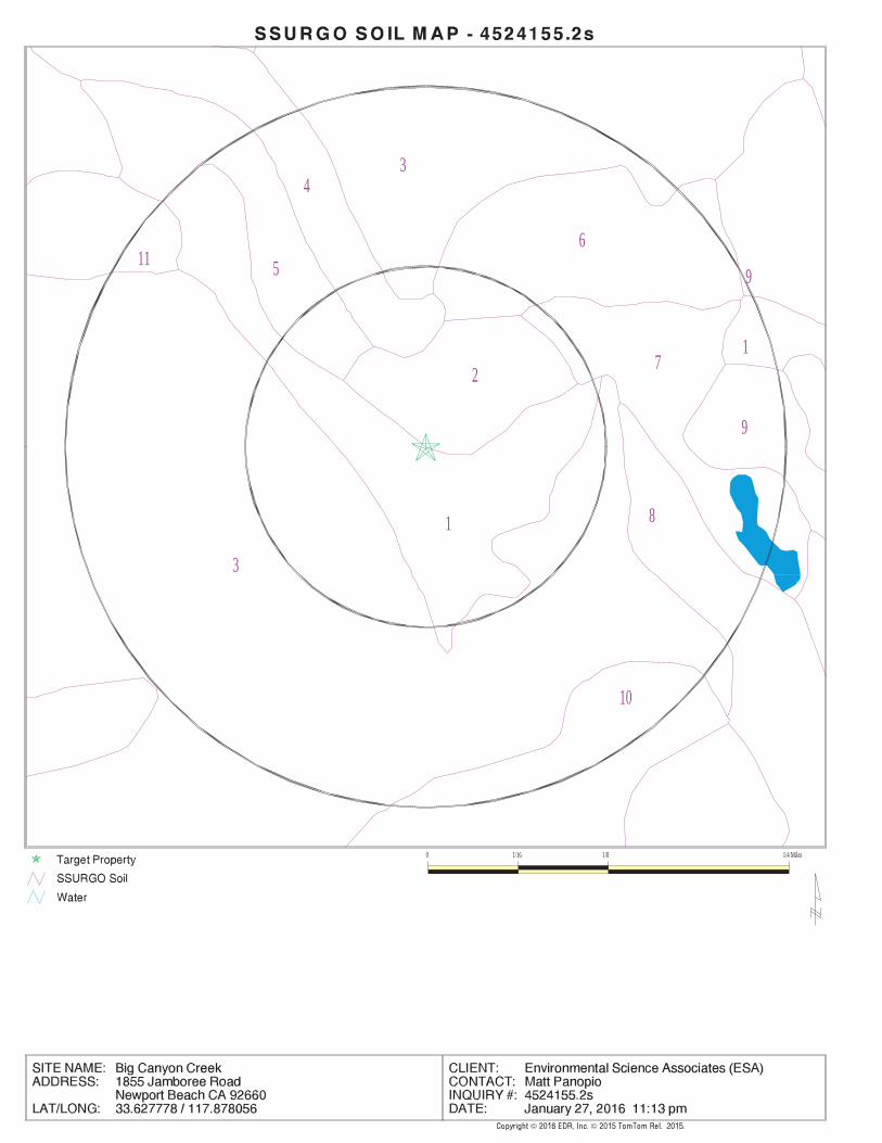
EDR Inc.EDR Inc.EDR Inc.EDR Inc.EDR Inc.EDR Inc.EDR Inc.EDR Inc.EDR Inc.EDR Inc.EDR Inc.EDR Inc.EDR Inc.EDR Inc.EDR Inc.EDR Inc.EDR Inc.EDR Inc.EDR Inc.EDR Inc.EDR Inc.EDR Inc.EDR Inc.EDR Inc.EDR Inc.EDR Inc.EDR Inc.EDR Inc.EDR Inc.EDR Inc.EDR Inc.EDR Inc.EDR Inc.EDR Inc.EDR Inc.EDR Inc.EDR Inc.EDR Inc.EDR Inc.EDR Inc.
34
5
1
611
9
3
17
2
9
8
10
0 1/16 1/8 1/4 Miles

TC4524155.2s Page A-6
Well drainedSoil Drainage Class:
textures.moderately well and well drained soils with moderately coarseClass B - Moderate infiltration rates. Deep and moderately deep,Hydrologic Group:
loamSoil Surface Texture:
SORRENTOSoil Component Name:
Soil Map ID: 2
Max: Min: Min: Max: Not reportedNot reported
bedrockweathered29 inches25 inches 2
Min: 6.1Max: 7.8
Min: 1.4Max: 4 Not reportedNot reportedclay loam25 inches 0 inches 1
Soil Layer Information
Boundary Classification Saturatedhydraulicconductivitymicro m/sec
Layer Upper Lower Soil Texture Class AASHTO Group Unified Soil Soil Reaction(pH)
> 0 inchesDepth to Watertable Min:
> 0 inchesDepth to Bedrock Min:
ModerateCorrosion Potential - Uncoated Steel:
Hydric Status: Not hydric
Well drainedSoil Drainage Class:
movement of water, or soils with moderately fine or fine textures.Class C - Slow infiltration rates. Soils with layers impeding downwardHydrologic Group:
clay loamSoil Surface Texture:
ANAHEIMSoil Component Name:
Soil Map ID: 1
in a landscape. The following information is based on Soil Conservation Service SSURGO data.for privately owned lands in the United States. A soil map in a soil survey is a representation of soil patternsSurvey (NCSS) and is responsible for collecting, storing, maintaining and distributing soil survey informationThe U.S. Department of Agriculture’s (USDA) Soil Conservation Service (SCS) leads the National Cooperative Soil
DOMINANT SOIL COMPOSITION IN GENERAL AREA OF TARGET PROPERTY
®GEOCHECK - PHYSICAL SETTING SOURCE SUMMARY®

TC4524155.2s Page A-7
> 0 inchesDepth to Watertable Min:
> 0 inchesDepth to Bedrock Min:
HighCorrosion Potential - Uncoated Steel:
Hydric Status: Not hydric
Moderately well drainedSoil Drainage Class:
water table, or are shallow to an impervious layer.Class D - Very slow infiltration rates. Soils are clayey, have a highHydrologic Group:
sandy loamSoil Surface Texture:
MYFORDSoil Component Name:
Soil Map ID: 3
Min: 7.9Max: 8.4
Min: 4Max: 14
Silty Sand.Sands with fines,SOILS, Sands,COARSE-GRAINED
and Sand.Clayey Gravel200), Silty, orpassing No.pct. or lessmaterials (35Granular
to silt loamloamy fine sandstratified72 inches61 inches 3
Min: 7.9Max: 8.4
Min: 1Max: 14.11
50%), Lean Claylimit less thanClays (liquidSOILS, Silts andFINE-GRAINED
Soils.200), Clayeypassing No.than 35 pct.Materials (moreSilt-Claysilty clay loam61 inches11 inches 2
Min: 6.1Max: 8.4
Min: 4Max: 14
50%), silt.limit less thanClays (liquidSOILS, Silts andFINE-GRAINED50%), Lean Clay.limit less thanClays (liquidSOILS, Silts andFINE-GRAINED
Soils.200), Siltypassing No.than 35 pct.Materials (moreSilt-Clayloam11 inches 0 inches 1
Soil Layer Information
Boundary Classification Saturatedhydraulicconductivitymicro m/sec
Layer Upper Lower Soil Texture Class AASHTO Group Unified Soil Soil Reaction(pH)
> 0 inchesDepth to Watertable Min:
> 0 inchesDepth to Bedrock Min:
HighCorrosion Potential - Uncoated Steel:
Hydric Status: Not hydric
®GEOCHECK - PHYSICAL SETTING SOURCE SUMMARY®

TC4524155.2s Page A-8
Min: 5.6Max: 7.3
Min: 14Max: 42
50%), silt.limit less thanClays (liquidSOILS, Silts andFINE-GRAINED
Soils.200), Siltypassing No.than 35 pct.Materials (moreSilt-Claysandy loam 7 inches 0 inches 1
Soil Layer Information
Boundary Classification Saturatedhydraulicconductivitymicro m/sec
Layer Upper Lower Soil Texture Class AASHTO Group Unified Soil Soil Reaction(pH)
> 0 inchesDepth to Watertable Min:
> 0 inchesDepth to Bedrock Min:
LowCorrosion Potential - Uncoated Steel:
Hydric Status: Not hydric
Somewhat excessively drainedSoil Drainage Class:
movement of water, or soils with moderately fine or fine textures.Class C - Slow infiltration rates. Soils with layers impeding downwardHydrologic Group:
sandy loamSoil Surface Texture:
CIENEBASoil Component Name:
Soil Map ID: 4
Min: 6.1Max: 6.5
Min: 4Max: 14 Not reportedNot reportedsandy loam79 inches70 inches 5
Min: 6.1Max: 8.4
Min: 0.01Max: 0.42 Not reportedNot reportedsandy clay loam70 inches38 inches 4
Min: 5.6Max: 8.4
Min: 0.01Max: 0.42 Not reportedNot reportedsandy clay loam38 inches27 inches 3
Min: 5.6Max: 8.4
Min: 0.01Max: 0.42 Not reportedNot reportedsandy clay27 inches22 inches 2
5.1Max: 6 Min:
Min: 14Max: 42 Not reportedNot reportedsandy loam22 inches 0 inches 1
Soil Layer Information
Boundary Classification Saturatedhydraulicconductivitymicro m/sec
Layer Upper Lower Soil Texture Class AASHTO Group Unified Soil Soil Reaction(pH)
®GEOCHECK - PHYSICAL SETTING SOURCE SUMMARY®

TC4524155.2s Page A-9
Well drainedSoil Drainage Class:
textures.moderately well and well drained soils with moderately coarseClass B - Moderate infiltration rates. Deep and moderately deep,Hydrologic Group:
clay loamSoil Surface Texture:
BALCOMSoil Component Name:
Soil Map ID: 6
Min: 8.4Max: 9.6
Min: Max: Not reportedNot reportedvariable59 inches 0 inches 1
Soil Layer Information
Boundary Classification Saturatedhydraulicconductivitymicro m/sec
Layer Upper Lower Soil Texture Class AASHTO Group Unified Soil Soil Reaction(pH)
> 0 inchesDepth to Watertable Min:
> 0 inchesDepth to Bedrock Min:
HighCorrosion Potential - Uncoated Steel:
Hydric Status: All hydricSoil Drainage Class:
water table, or are shallow to an impervious layer.Class D - Very slow infiltration rates. Soils are clayey, have a highHydrologic Group:
variableSoil Surface Texture:
TIDAL FLATSSoil Component Name:
Soil Map ID: 5
Max: Min: Min: 0Max: 0.42 Not reportedNot reported
bedrockweathered11 inches 7 inches 2
Soil Layer Information
Boundary Classification Saturatedhydraulicconductivitymicro m/sec
Layer Upper Lower Soil Texture Class AASHTO Group Unified Soil Soil Reaction(pH)
®GEOCHECK - PHYSICAL SETTING SOURCE SUMMARY®

TC4524155.2s Page A-10
Min: 7.9Max: 8.4
Min: 14Max: 42
50%), silt.limit less thanClays (liquidSOILS, Silts andFINE-GRAINED
Soils.200), Siltypassing No.than 35 pct.Materials (moreSilt-Clayfine sandy loam 7 inches 0 inches 1
Soil Layer Information
Boundary Classification Saturatedhydraulicconductivitymicro m/sec
Layer Upper Lower Soil Texture Class AASHTO Group Unified Soil Soil Reaction(pH)
> 0 inchesDepth to Watertable Min:
> 0 inchesDepth to Bedrock Min:
HighCorrosion Potential - Uncoated Steel:
Hydric Status: Not hydric
Well drainedSoil Drainage Class:
textures.moderately well and well drained soils with moderately coarseClass B - Moderate infiltration rates. Deep and moderately deep,Hydrologic Group:
fine sandy loamSoil Surface Texture:
SAN EMIGDIOSoil Component Name:
Soil Map ID: 7
Max: Min: Min: Max: Not reportedNot reported
bedrockweathered33 inches29 inches 2
Min: 7.9Max: 8.4
Min: 1.4Max: 4 Not reportedNot reportedclay loam29 inches 0 inches 1
Soil Layer Information
Boundary Classification Saturatedhydraulicconductivitymicro m/sec
Layer Upper Lower Soil Texture Class AASHTO Group Unified Soil Soil Reaction(pH)
> 0 inchesDepth to Watertable Min:
> 0 inchesDepth to Bedrock Min:
ModerateCorrosion Potential - Uncoated Steel:
Hydric Status: Not hydric
®GEOCHECK - PHYSICAL SETTING SOURCE SUMMARY®

TC4524155.2s Page A-11
> 0 inchesDepth to Watertable Min:
> 0 inchesDepth to Bedrock Min:
ModerateCorrosion Potential - Uncoated Steel:
Hydric Status: Not hydric
Well drainedSoil Drainage Class:
movement of water, or soils with moderately fine or fine textures.Class C - Slow infiltration rates. Soils with layers impeding downwardHydrologic Group:
clay loamSoil Surface Texture:
ANAHEIMSoil Component Name:
Soil Map ID: 8
Min: 7.9Max: 8.4
Min: 14Max: 42
50%), Lean Claylimit less thanClays (liquidSOILS, Silts andFINE-GRAINED
Soils.200), Siltypassing No.than 35 pct.Materials (moreSilt-Clay
loamvery fine sandycoarse sand togravelly loamystratified61 inches44 inches 4
Min: 7.9Max: 8.4
Min: 1.4Max: 4
50%), Lean Claylimit less thanClays (liquidSOILS, Silts andFINE-GRAINED
Soils.200), Clayeypassing No.than 35 pct.Materials (moreSilt-Claysilty clay loam44 inches40 inches 3
Min: 7.9Max: 8.4
Min: 14Max: 42
50%), Lean Claylimit less thanClays (liquidSOILS, Silts andFINE-GRAINED
Soils.200), Siltypassing No.than 35 pct.Materials (moreSilt-Clay
loamvery fine sandycoarse sand togravelly loamystratified40 inches 7 inches 2
Soil Layer Information
Boundary Classification Saturatedhydraulicconductivitymicro m/sec
Layer Upper Lower Soil Texture Class AASHTO Group Unified Soil Soil Reaction(pH)
®GEOCHECK - PHYSICAL SETTING SOURCE SUMMARY®
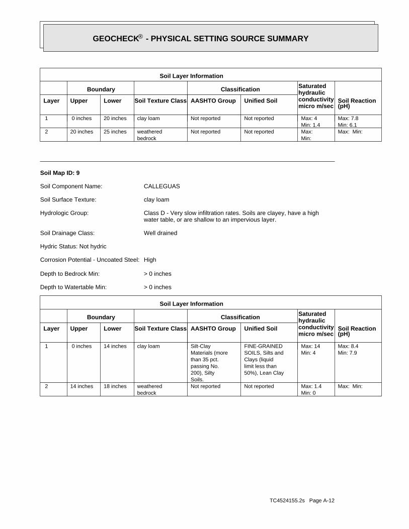
TC4524155.2s Page A-12
Max: Min: Min: 0Max: 1.4 Not reportedNot reported
bedrockweathered18 inches14 inches 2
Min: 7.9Max: 8.4
Min: 4Max: 14
50%), Lean Claylimit less thanClays (liquidSOILS, Silts andFINE-GRAINED
Soils.200), Siltypassing No.than 35 pct.Materials (moreSilt-Clayclay loam14 inches 0 inches 1
Soil Layer Information
Boundary Classification Saturatedhydraulicconductivitymicro m/sec
Layer Upper Lower Soil Texture Class AASHTO Group Unified Soil Soil Reaction(pH)
> 0 inchesDepth to Watertable Min:
> 0 inchesDepth to Bedrock Min:
HighCorrosion Potential - Uncoated Steel:
Hydric Status: Not hydric
Well drainedSoil Drainage Class:
water table, or are shallow to an impervious layer.Class D - Very slow infiltration rates. Soils are clayey, have a highHydrologic Group:
clay loamSoil Surface Texture:
CALLEGUASSoil Component Name:
Soil Map ID: 9
Max: Min: Min: Max: Not reportedNot reported
bedrockweathered25 inches20 inches 2
Min: 6.1Max: 7.8
Min: 1.4Max: 4 Not reportedNot reportedclay loam20 inches 0 inches 1
Soil Layer Information
Boundary Classification Saturatedhydraulicconductivitymicro m/sec
Layer Upper Lower Soil Texture Class AASHTO Group Unified Soil Soil Reaction(pH)
®GEOCHECK - PHYSICAL SETTING SOURCE SUMMARY®

TC4524155.2s Page A-13
> 0 inchesDepth to Watertable Min:
> 0 inchesDepth to Bedrock Min:
ModerateCorrosion Potential - Uncoated Steel:
Hydric Status: Not hydric
Well drainedSoil Drainage Class:
movement of water, or soils with moderately fine or fine textures.Class C - Slow infiltration rates. Soils with layers impeding downwardHydrologic Group:
clay loamSoil Surface Texture:
ANAHEIMSoil Component Name:
Soil Map ID: 11
Min: 5.6Max: 6.5
Min: 4Max: 14 Not reportedNot reportedsand79 inches59 inches 3
Min: 5.6Max: 7.3
Min: 4Max: 14 Not reportedNot reportedsand59 inches33 inches 2
Min: 5.6Max: 7.3
Min: 4Max: 14 Not reportedNot reportedloamy sand33 inches 0 inches 1
Soil Layer Information
Boundary Classification Saturatedhydraulicconductivitymicro m/sec
Layer Upper Lower Soil Texture Class AASHTO Group Unified Soil Soil Reaction(pH)
> 0 inchesDepth to Watertable Min:
> 0 inchesDepth to Bedrock Min:
LowCorrosion Potential - Uncoated Steel:
Hydric Status: Not hydric
Somewhat excessively drainedSoil Drainage Class:
textures.moderately well and well drained soils with moderately coarseClass B - Moderate infiltration rates. Deep and moderately deep,Hydrologic Group:
loamy sandSoil Surface Texture:
MARINASoil Component Name:
Soil Map ID: 10
®GEOCHECK - PHYSICAL SETTING SOURCE SUMMARY®

TC4524155.2s Page A-14
1/8 - 1/4 Mile SSWCAOG11000217858 1
STATE OIL/GAS WELL INFORMATION
LOCATIONFROM TPWELL IDMAP ID
OTHER STATE DATABASE INFORMATION
No Wells Found
STATE DATABASE WELL INFORMATION
LOCATIONFROM TPWELL IDMAP ID
Note: PWS System location is not always the same as well location.
No PWS System Found
FEDERAL FRDS PUBLIC WATER SUPPLY SYSTEM INFORMATION
LOCATIONFROM TPWELL IDMAP ID
No Wells Found
FEDERAL USGS WELL INFORMATION
LOCATIONFROM TPWELL IDMAP ID
1.000State DatabaseNearest PWS within 0.001 milesFederal FRDS PWS1.000Federal USGS
WELL SEARCH DISTANCE INFORMATION
SEARCH DISTANCE (miles)DATABASE
opinion about the impact of contaminant migration on nearby drinking water wells.professional in assessing sources that may impact ground water flow direction, and in forming anEDR Local/Regional Water Agency records provide water well information to assist the environmental
LOCAL / REGIONAL WATER AGENCY RECORDS
Max: Min: Min: Max: Not reportedNot reported
bedrockweathered29 inches25 inches 2
Min: 6.1Max: 7.8
Min: 1.4Max: 4 Not reportedNot reportedclay loam25 inches 0 inches 1
Soil Layer Information
Boundary Classification Saturatedhydraulicconductivitymicro m/sec
Layer Upper Lower Soil Texture Class AASHTO Group Unified Soil Soil Reaction(pH)
®GEOCHECK - PHYSICAL SETTING SOURCE SUMMARY®

TC4524155.2s Page A-15
1/2 - 1 Mile WSWCAOG11000217947 41/2 - 1 Mile NorthCAOG11000217859 31/4 - 1/2 Mile WNWCAOG11000218066 2
STATE OIL/GAS WELL INFORMATION
LOCATIONFROM TPWELL IDMAP ID
®GEOCHECK - PHYSICAL SETTING SOURCE SUMMARY®

EDR Inc.EDR Inc.EDR Inc.EDR Inc.EDR Inc.EDR Inc.EDR Inc.EDR Inc.EDR Inc.EDR Inc.EDR Inc.EDR Inc.EDR Inc.EDR Inc.EDR Inc.EDR Inc.EDR Inc.EDR Inc.EDR Inc.EDR Inc.EDR Inc.EDR Inc.EDR Inc.EDR Inc.EDR Inc.EDR Inc.EDR Inc.EDR Inc.EDR Inc.EDR Inc.EDR Inc.EDR Inc.EDR Inc.EDR Inc.EDR Inc.EDR Inc.EDR Inc.EDR Inc.EDR Inc.EDR Inc.
1 2 0
12
0
80
80
8 0
80
80
8 0
80
80
4 0
40
40
40
40
4 08 0
80
1 2 0 16
0
120
120
40
40
4 0
880
8 0
80
8 0
120
20
02
00
200
1 2 0
1 2 0
12
0
12
0
12
0
1 2 0
2 0 0
2 0 0
200
2 0 020
0
200
16
01
20
80
80
1 2 0
12
0
16
0
16
0
16
0
160
1 6 0
1 6 0
1 6 0
16
0
2 0 0
2
0 02 0 0
2 0 0
80
8 0
40
20
0
4 01
6 0
16
0
12 0
12
0
80
1
2 0
80
8 0
40
4 0
40
8
0 2
0 02 0080
20
0
80
2 0 0
2 0 0
20
0
20 0
1 2 0
1
2 0
20
0
2 0 0
20
0
1
6 0 1 6 0
1 6 0
16
0
2 0 02 0 02 0 0
200
20
0
20
0
1
20
200
3 6
36
032
0
28
0
2 4 0
24
0
24
0
24
0
240
16 0
CA

TC4524155.2s Page A-17
Date: 09/24/1998Average Water Depth: 9.86Deep Water Depth: Not ReportedShallow Water Depth: Not ReportedGroundwater Flow: NWSite ID: 083000097T2
SSW1/4 - 1/2 MileHigher
37878AQUIFLOW
Date: 06/1996Average Water Depth: Not ReportedDeep Water Depth: 9.34Shallow Water Depth: 4.66Groundwater Flow: NESite ID: 083001663T1
SSW1/8 - 1/4 MileHigher
66482AQUIFLOW
Map IDDirectionDistanceElevation EDR ID NumberDatabase
®GEOCHECK - PHYSICAL SETTING SOURCE MAP FINDINGS®

TC4524155.2s Page A-18
3North1/2 - 1 Mile
CAOG11000217859OIL_GAS
CAOG11000218066Site id:PDHGissymbol:UnknownDirectiona:Not ReportedCompletion:Not ReportedAbandonedd:
0Redrillfoo:0Welldeptha:
Not ReportedSpuddate:NConfidenti:NHydraulica:NEpawell:1Wellnumber:Not ReportedLeasename:
Not ReportedComments:hudGissourcec:Not ReportedLocationde:
Not ReportedElevation:SBBase meridian:10WRange:06STownship:24Section:Any AreaArea name:Any FieldFieldname:OrangeCounty name:
F. A. WinchesterOperator name:PWell status:YDryhole:Not ReportedRedrill can:NBlm well:05901291Api number:1District nun:
2WNW1/4 - 1/2 Mile
CAOG11000218066OIL_GAS
CAOG11000217858Site id:PDHGissymbol:UnknownDirectiona:Not ReportedCompletion:Not ReportedAbandonedd:
0Redrillfoo:0Welldeptha:
Not ReportedSpuddate:NConfidenti:NHydraulica:NEpawell:55-1Wellnumber:IrvineLeasename:
Not ReportedComments:hudGissourcec:Not ReportedLocationde:
Not ReportedElevation:SBBase meridian:10WRange:06STownship:25Section:Any AreaArea name:Any FieldFieldname:OrangeCounty name:
Morton and SonsOperator name:PWell status:YDryhole:Not ReportedRedrill can:NBlm well:05901075Api number:1District nun:
1SSW1/8 - 1/4 Mile
CAOG11000217858OIL_GAS
Map IDDirectionDistance EDR ID NumberDatabase
®GEOCHECK - PHYSICAL SETTING SOURCE MAP FINDINGS®
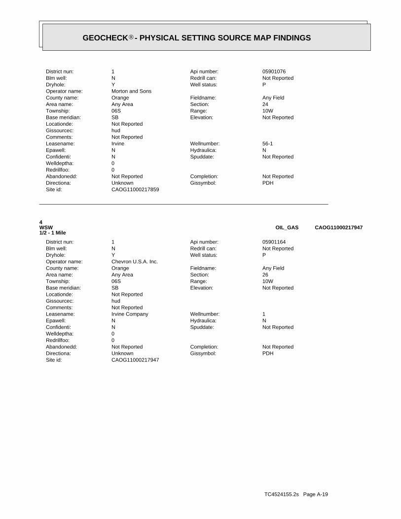
TC4524155.2s Page A-19
CAOG11000217947Site id:PDHGissymbol:UnknownDirectiona:Not ReportedCompletion:Not ReportedAbandonedd:
0Redrillfoo:0Welldeptha:
Not ReportedSpuddate:NConfidenti:NHydraulica:NEpawell:1Wellnumber:Irvine CompanyLeasename:
Not ReportedComments:hudGissourcec:Not ReportedLocationde:
Not ReportedElevation:SBBase meridian:10WRange:06STownship:26Section:Any AreaArea name:Any FieldFieldname:OrangeCounty name:
Chevron U.S.A. Inc.Operator name:PWell status:YDryhole:Not ReportedRedrill can:NBlm well:05901164Api number:1District nun:
4WSW1/2 - 1 Mile
CAOG11000217947OIL_GAS
CAOG11000217859Site id:PDHGissymbol:UnknownDirectiona:Not ReportedCompletion:Not ReportedAbandonedd:
0Redrillfoo:0Welldeptha:
Not ReportedSpuddate:NConfidenti:NHydraulica:NEpawell:56-1Wellnumber:IrvineLeasename:
Not ReportedComments:hudGissourcec:Not ReportedLocationde:
Not ReportedElevation:SBBase meridian:10WRange:06STownship:24Section:Any AreaArea name:Any FieldFieldname:OrangeCounty name:
Morton and SonsOperator name:PWell status:YDryhole:Not ReportedRedrill can:NBlm well:05901076Api number:1District nun:
®GEOCHECK - PHYSICAL SETTING SOURCE MAP FINDINGS®
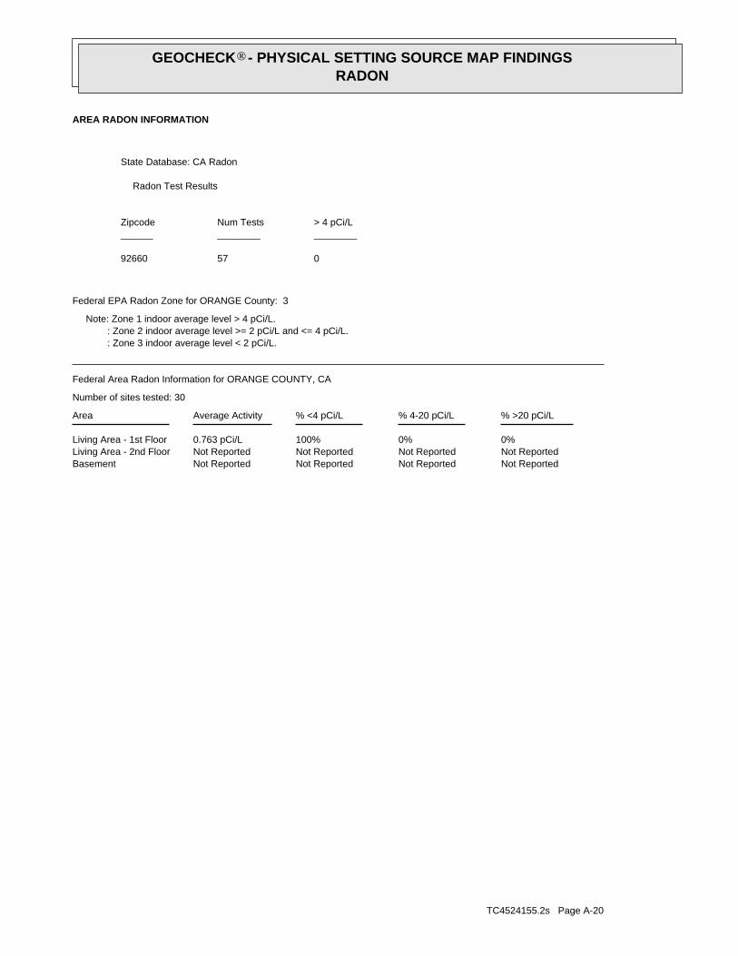
TC4524155.2s Page A-20
Not ReportedNot ReportedNot ReportedNot ReportedBasementNot ReportedNot ReportedNot ReportedNot ReportedLiving Area - 2nd Floor0%0%100%0.763 pCi/LLiving Area - 1st Floor
% >20 pCi/L% 4-20 pCi/L% <4 pCi/LAverage ActivityArea
Number of sites tested: 30
Federal Area Radon Information for ORANGE COUNTY, CA
: Zone 3 indoor average level < 2 pCi/L. : Zone 2 indoor average level >= 2 pCi/L and <= 4 pCi/L. Note: Zone 1 indoor average level > 4 pCi/L.
Federal EPA Radon Zone for ORANGE County: 3
05792660
______________________> 4 pCi/LNum TestsZipcode
Radon Test Results
State Database: CA Radon
AREA RADON INFORMATION
®GEOCHECK - PHYSICAL SETTING SOURCE MAP FINDINGSRADON
®

TOPOGRAPHIC INFORMATION
USGS 7.5’ Digital Elevation Model (DEM)Source: United States Geologic SurveyEDR acquired the USGS 7.5’ Digital Elevation Model in 2002 and updated it in 2006. The 7.5 minute DEM correspondsto the USGS 1:24,000- and 1:25,000-scale topographic quadrangle maps. The DEM provides elevation datawith consistent elevation units and projection.
Current USGS 7.5 Minute Topographic MapSource: U.S. Geological Survey
HYDROLOGIC INFORMATION
Flood Zone Data: This data, available in select counties across the country, was obtained by EDR in 2003 & 2011 from the FederalEmergency Management Agency (FEMA). Data depicts 100-year and 500-year flood zones as defined by FEMA.
NWI: National Wetlands Inventory. This data, available in select counties across the country, was obtained by EDRin 2002, 2005 and 2010 from the U.S. Fish and Wildlife Service.
State Wetlands Data: Wetland InventorySource: Department of Fish & GameTelephone: 916-445-0411
HYDROGEOLOGIC INFORMATION
AQUIFLOW Information SystemR
Source: EDR proprietary database of groundwater flow informationEDR has developed the AQUIFLOW Information System (AIS) to provide data on the general direction of groundwater
flow at specific points. EDR has reviewed reports submitted to regulatory authorities at select sites and hasextracted the date of the report, hydrogeologically determined groundwater flow direction and depth to water tableinformation.
GEOLOGIC INFORMATION
Geologic Age and Rock Stratigraphic UnitSource: P.G. Schruben, R.E. Arndt and W.J. Bawiec, Geology of the Conterminous U.S. at 1:2,500,000 Scale - A digitalrepresentation of the 1974 P.B. King and H.M. Beikman Map, USGS Digital Data Series DDS - 11 (1994).
STATSGO: State Soil Geographic DatabaseSource: Department of Agriculture, Natural Resources Conservation Service (NRCS)The U.S. Department of Agriculture’s (USDA) Natural Resources Conservation Service (NRCS) leads the nationalConservation Soil Survey (NCSS) and is responsible for collecting, storing, maintaining and distributing soilsurvey information for privately owned lands in the United States. A soil map in a soil survey is a representationof soil patterns in a landscape. Soil maps for STATSGO are compiled by generalizing more detailed (SSURGO)soil survey maps.
SSURGO: Soil Survey Geographic DatabaseSource: Department of Agriculture, Natural Resources Conservation Service (NRCS)Telephone: 800-672-5559SSURGO is the most detailed level of mapping done by the Natural Resources Conservation Service, mappingscales generally range from 1:12,000 to 1:63,360. Field mapping methods using national standards are used toconstruct the soil maps in the Soil Survey Geographic (SSURGO) database. SSURGO digitizing duplicates theoriginal soil survey maps. This level of mapping is designed for use by landowners, townships and countynatural resource planning and management.
TC4524155.2s Page PSGR-1
PHYSICAL SETTING SOURCE RECORDS SEARCHED
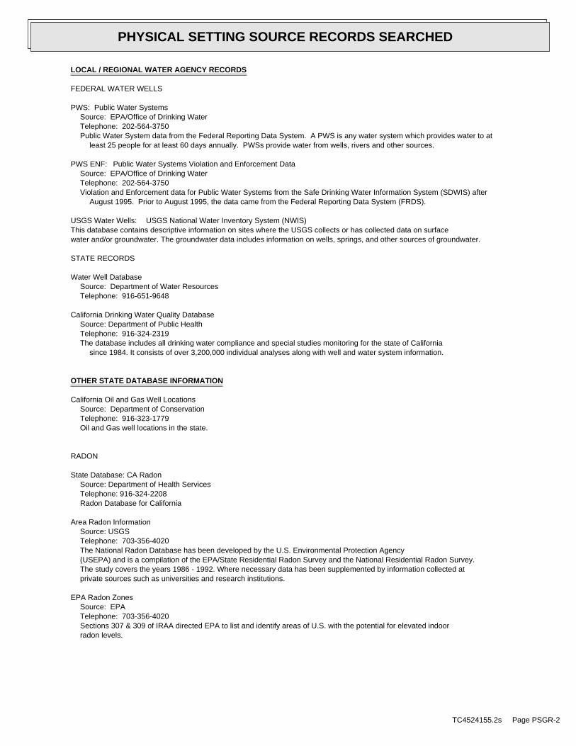
LOCAL / REGIONAL WATER AGENCY RECORDS
FEDERAL WATER WELLS
PWS: Public Water SystemsSource: EPA/Office of Drinking WaterTelephone: 202-564-3750Public Water System data from the Federal Reporting Data System. A PWS is any water system which provides water to at
least 25 people for at least 60 days annually. PWSs provide water from wells, rivers and other sources.
PWS ENF: Public Water Systems Violation and Enforcement DataSource: EPA/Office of Drinking WaterTelephone: 202-564-3750Violation and Enforcement data for Public Water Systems from the Safe Drinking Water Information System (SDWIS) after
August 1995. Prior to August 1995, the data came from the Federal Reporting Data System (FRDS).
USGS Water Wells: USGS National Water Inventory System (NWIS)This database contains descriptive information on sites where the USGS collects or has collected data on surfacewater and/or groundwater. The groundwater data includes information on wells, springs, and other sources of groundwater.
STATE RECORDS
Water Well DatabaseSource: Department of Water ResourcesTelephone: 916-651-9648
California Drinking Water Quality DatabaseSource: Department of Public HealthTelephone: 916-324-2319The database includes all drinking water compliance and special studies monitoring for the state of California
since 1984. It consists of over 3,200,000 individual analyses along with well and water system information.
OTHER STATE DATABASE INFORMATION
California Oil and Gas Well LocationsSource: Department of ConservationTelephone: 916-323-1779Oil and Gas well locations in the state.
RADON
State Database: CA RadonSource: Department of Health ServicesTelephone: 916-324-2208Radon Database for California
Area Radon InformationSource: USGSTelephone: 703-356-4020The National Radon Database has been developed by the U.S. Environmental Protection Agency(USEPA) and is a compilation of the EPA/State Residential Radon Survey and the National Residential Radon Survey.The study covers the years 1986 - 1992. Where necessary data has been supplemented by information collected atprivate sources such as universities and research institutions.
EPA Radon ZonesSource: EPATelephone: 703-356-4020Sections 307 & 309 of IRAA directed EPA to list and identify areas of U.S. with the potential for elevated indoorradon levels.
TC4524155.2s Page PSGR-2
PHYSICAL SETTING SOURCE RECORDS SEARCHED

OTHER
Airport Landing Facilities: Private and public use landing facilitiesSource: Federal Aviation Administration, 800-457-6656
Epicenters: World earthquake epicenters, Richter 5 or greaterSource: Department of Commerce, National Oceanic and Atmospheric Administration
California Earthquake Fault Lines: The fault lines displayed on EDR’s Topographic map are digitized quaternary fault lines,prepared in 1975 by the United State Geological Survey. Additional information (also from 1975) regarding activity at specific faultlines comes from California’s Preliminary Fault Activity Map prepared by the California Division of Mines and Geology.
STREET AND ADDRESS INFORMATION
© 2015 TomTom North America, Inc. All rights reserved. This material is proprietary and the subject of copyright protectionand other intellectual property rights owned by or licensed to Tele Atlas North America, Inc. The use of this material is subjectto the terms of a license agreement. You will be held liable for any unauthorized copying or disclosure of this material.
TC4524155.2s Page PSGR-3
PHYSICAL SETTING SOURCE RECORDS SEARCHED

MAP FINDINGSMap IDDirection
EDR ID NumberDistanceEPA ID NumberDatabase(s)SiteElevation
B10 CA FID USTBIG CANYON COUNTRY CLUB 1000106106NE CA HIST CORTESE1850 N/A< 1/8 NEWPORT BEACH, CA 92660
Relative:Higher
Actual:72 ft.
0.051 mi.268 ft. Site 2 of 3 in cluster B
CA FID UST: 30000419Facility ID: UTNKARegulated By: Not reportedRegulated ID: Not reportedCortese Code: Not reportedSIC Code: 7146445404Facility Phone: Not reportedMail To: 1 BIG CANYON DRMailing Address: Not reportedMailing Address 2: NEWPORT BEACH 92660Mailing City,St,Zip: Not reportedContact: Not reportedContact Phone:
Not reportedDUNs Number: Not reportedNPDES Number: Not reportedEPA ID: Not reportedComments: ActiveStatus:
HIST CORTESE: CORTESERegion: 30Facility County Code: LTNKAReg By: 083000064TReg Id:
Page: 1

MAP FINDINGSMap IDDirection
EDR ID NumberDistanceEPA ID NumberDatabase(s)SiteElevation
25 RCRA-SQGFOUR SEASONS HOTEL 1000351769SSE CA LUST690 NEWPORT CENTER CAD9816357821/4-1/2 CA USTNEWPORT BEACH, CA 92660
Relative:Higher
Actual:225 ft.
0.500 mi. CA SWEEPS UST2640 ft. CA FID UST
FINDSCA HIST CORTESE
RCRA-SQG: 09/01/1996Date form received by agency: FOUR SEASONS HOTELFacility name: 690 NEWPORT CENTERFacility address: NEWPORT BEACH, CA 92660 CAD981635782EPA ID: 690 NEWPORT CENTER DRMailing address: NEWPORT BEACH, CA 92660 Not reportedContact: Not reportedContact address: Not reported USContact country: Not reportedContact telephone: Not reportedContact email: 09EPA Region: Small Small Quantity GeneratorClassification: Handler: generates more than 100 and less than 1000 kg of hazardousDescription: waste during any calendar month and accumulates less than 6000 kg of hazardous waste at any time; or generates 100 kg or less of hazardous waste during any calendar month, and accumulates more than 1000 kg of hazardous waste at any time
Owner/Operator Summary: FOUR SEASONS CORPOwner/operator name: NOT REQUIREDOwner/operator address: NOT REQUIRED, ME 99999 Not reportedOwner/operator country: (415) 555-1212Owner/operator telephone: PrivateLegal status: OwnerOwner/Operator Type: Not reportedOwner/Op start date: Not reportedOwner/Op end date:
NOT REQUIREDOwner/operator name: NOT REQUIREDOwner/operator address: NOT REQUIRED, ME 99999 Not reportedOwner/operator country: (415) 555-1212Owner/operator telephone: PrivateLegal status: OperatorOwner/Operator Type: Not reportedOwner/Op start date: Not reportedOwner/Op end date:
Handler Activities Summary: NoU.S. importer of hazardous waste: NoMixed waste (haz. and radioactive): NoRecycler of hazardous waste: NoTransporter of hazardous waste: NoTreater, storer or disposer of HW: NoUnderground injection activity:
Page: 1

MAP FINDINGSMap IDDirection
EDR ID NumberDistanceEPA ID NumberDatabase(s)SiteElevation
NoOn-site burner exemption: NoFurnace exemption: NoUsed oil fuel burner: NoUsed oil processor: NoUser oil refiner: NoUsed oil fuel marketer to burner: NoUsed oil Specification marketer: NoUsed oil transfer facility: NoUsed oil transporter:
Historical Generators: 12/15/1986Date form received by agency: FOUR SEASONS HOTELSite name: Large Quantity GeneratorClassification:
No violations foundViolation Status:
LUST: STATERegion: T0605902093Global Id: 33.6194517Latitude: -117.875762Longitude: LUST Cleanup SiteCase Type: Completed - Case ClosedStatus: 01/28/2015Status Date: ORANGE COUNTY LOPLead Agency: DBCase Worker: ORANGE COUNTY LOPLocal Agency: 083003073TRB Case Number: 97UT041LOC Case Number: Local AgencyFile Location: Other Groundwater (uses other than drinking water)Potential Media Affect: DieselPotential Contaminants of Concern: Please refer to recent Site Documents or Monitoring Reports inSite History: GeoTracker for site history. Orange County is not responsible for the accuracy of any professional interpretations provided in reports submitted by consultants for the responsible party.
Click here to access the California GeoTracker records for this facility:
Contact: T0605902093Global Id: Regional Board CaseworkerContact Type: TOM E. MBEKE-EKANEMContact Name: SANTA ANA RWQCB (REGION 8)Organization Name: 3737 MAIN STREET, SUITE 500Address: RIVERSIDECity: [email protected]: 9513202007Phone Number:
T0605902093Global Id: Local Agency CaseworkerContact Type: DENAMARIE BAKERContact Name: ORANGE COUNTY LOPOrganization Name: 1241 E. DYER ROAD, STE. 120Address: SANTA ANACity: [email protected]: 7144336255Phone Number:
Page: 2

MAP FINDINGSMap IDDirection
EDR ID NumberDistanceEPA ID NumberDatabase(s)SiteElevation
Status History: T0605902093Global Id: Completed - Case ClosedStatus: 01/28/2015Status Date:
T0605902093Global Id: Open - Case Begin DateStatus: 09/19/1997Status Date:
T0605902093Global Id: Open - Eligible for ClosureStatus: 01/17/2013Status Date:
T0605902093Global Id: Open - RemediationStatus: 02/26/2003Status Date:
Regulatory Activities: T0605902093Global Id: ENFORCEMENTAction Type: 07/03/2009Date: Staff LetterAction:
T0605902093Global Id: ENFORCEMENTAction Type: 11/04/1997Date: Notice of ResponsibilityAction:
T0605902093Global Id: ENFORCEMENTAction Type: 10/17/2003Date: Staff LetterAction:
T0605902093Global Id: ENFORCEMENTAction Type: 09/16/2004Date: Staff LetterAction:
T0605902093Global Id: ENFORCEMENTAction Type: 07/19/2005Date: Staff LetterAction:
T0605902093Global Id: ENFORCEMENTAction Type: 05/09/2008Date: Staff LetterAction:
T0605902093Global Id: ENFORCEMENTAction Type: 04/17/2012Date: Staff LetterAction:
T0605902093Global Id: ENFORCEMENTAction Type: 07/30/2014Date:
Notification - Public Notice of Case ClosureAction:
T0605902093Global Id:
Page: 3

MAP FINDINGSMap IDDirection
EDR ID NumberDistanceEPA ID NumberDatabase(s)SiteElevation
ENFORCEMENTAction Type: 07/21/2008Date: Staff LetterAction:
T0605902093Global Id: ENFORCEMENTAction Type: 01/28/2015Date: Closure/No Further Action LetterAction:
T0605902093Global Id: OtherAction Type: 07/10/1997Date: Leak DiscoveryAction:
T0605902093Global Id: REMEDIATIONAction Type: 10/20/1998Date: Free Product RemovalAction:
T0605902093Global Id: ENFORCEMENTAction Type: 01/07/2011Date: Staff LetterAction:
T0605902093Global Id: ENFORCEMENTAction Type: 07/30/2014Date: Notification - Public Participation DocumentAction:
T0605902093Global Id: REMEDIATIONAction Type: 07/15/2008Date: Other (Use Description Field)Action:
T0605902093Global Id: OtherAction Type: 07/11/1997Date: Leak ReportedAction:
T0605902093Global Id: ENFORCEMENTAction Type: 12/29/2009Date: Staff LetterAction:
T0605902093Global Id: ENFORCEMENTAction Type: 01/17/2013Date: Staff LetterAction:
T0605902093Global Id: ENFORCEMENTAction Type: 09/30/2014Date: Staff LetterAction:
T0605902093Global Id: RESPONSEAction Type: 02/04/1998Date: Preliminary Site Assessment WorkplanAction:
Page: 4

MAP FINDINGSMap IDDirection
EDR ID NumberDistanceEPA ID NumberDatabase(s)SiteElevation
ORANGE CO. LUST: ORANGERegion: 97UT041Facility Id: Certification (Case Closed)Current Status: Diesel fuel oil and additives, Nos.1-D, 2-D, 2-4Released Substance: 01/28/2015Date Closed: Other Ground WaterCase Type: RO0002035Record ID:
LUST REG 8: 8Region: OrangeCounty: Santa Ana RegionRegional Board: Remediation PlanFacility Status: 083003073TCase Number: 97UT041Local Case Num: Other ground water affectedCase Type: DieselSubstance: 0Qty Leaked: Not reportedAbate Method: Not reportedCross Street: NOREnf Type: Not reportedFunding: LTHow Discovered: NPPHow Stopped: UnknownLeak Cause: PipingLeak Source: T0605902093Global ID: 9/9/9999How Stopped Date: Not reportedEnter Date: Not reportedDate Confirmation of Leak Began: Not reportedDate Preliminary Assessment Began: 9/19/1997Discover Date: Not reportedEnforcement Date: Not reportedClose Date: Not reportedDate Prelim Assessment Workplan Submitted: Not reportedDate Pollution Characterization Began: 2/26/2003Date Remediation Plan Submitted: Not reportedDate Remedial Action Underway: Not reportedDate Post Remedial Action Monitoring: Not reportedEnter Date: =GW Qualifies: Not reportedSoil Qualifies: Not reportedOperator: Not reportedFacility Contact: Not reportedInterim: LUSTOversite Program: 33.6194517Latitude: -117.875762Longitude: 9/10/2004MTBE Date:
270Max MTBE GW: 0MTBE Concentration: Not reportedMax MTBE Soil: 0MTBE Fuel: MTBE Detected. Site tested for MTBE & MTBE detectedMTBE Tested: *MTBE Class: TMEStaff: JKStaff Initials: Local AgencyLead Agency:
Page: 5

MAP FINDINGSMap IDDirection
EDR ID NumberDistanceEPA ID NumberDatabase(s)SiteElevation
30000LLocal Agency: Not reportedHydr Basin #: EST,MAR,RARE,SHELL,SPWN,WET,WILDBeneficial: Not reportedPriority: Not reportedCleanup Fund Id: Not reportedWork Suspended:Not reportedSummary:
UST: 4052Facility ID: ORANGE COUNTYPermitting Agency: 33.6211143Latitude: -117.8738808Longitude:
ORANGE CO. UST:FA0024638Facility ID:
SWEEPS UST: ActiveStatus: 4052Comp Number: 9Number: 44-016110Board Of Equalization: 09-30-92Referral Date: 09-15-92Action Date: 02-29-88Created Date: Not reportedOwner Tank Id: 30-000-004052-000001SWRCB Tank Id: ATank Status: 1000Capacity: Not reportedActive Date: M.V. FUELTank Use: PSTG: DIESELContent: 1Number Of Tanks:
CA FID UST: 30006786Facility ID: UTNKARegulated By: Not reportedRegulated ID: Not reportedCortese Code: Not reportedSIC Code: 7147590808Facility Phone: Not reportedMail To: 690 NEWPORT CENTER DRMailing Address: Not reportedMailing Address 2: NEWPORT BEACH 92660Mailing City,St,Zip:
Not reportedContact: Not reportedContact Phone: Not reportedDUNs Number: Not reportedNPDES Number: Not reportedEPA ID: Not reportedComments: ActiveStatus:
FINDS:
110002417545Registry ID:
Page: 6

MAP FINDINGSMap IDDirection
EDR ID NumberDistanceEPA ID NumberDatabase(s)SiteElevation
Environmental Interest/Information SystemAIR EMISSIONS CLASSIFICATION UNKNOWN
RCRAInfo is a national information system that supports the ResourceConservation and Recovery Act (RCRA) program through the tracking ofevents and activities related to facilities that generate, transport,and treat, store, or dispose of hazardous waste. RCRAInfo allows RCRAprogram staff to track the notification, permit, compliance, andcorrective action activities required under RCRA.
HIST CORTESE: CORTESERegion: 30Facility County Code: LTNKAReg By: 083003073TReg Id:
Page: 7

MAP FINDINGSMap IDDirection
EDR ID NumberDistanceEPA ID NumberDatabase(s)SiteElevation
D23 RCRA-SQGLAND ROVER NEWPORT BEACH 1000364520SSW CA LUST1540 JAMBOREE RD CAD9819674411/8-1/4 CA USTNEWPORT BEACH, CA 92660
Relative:Higher
Actual:123 ft.
0.198 mi. CA HIST UST1044 ft. CA FID USTSite 2 of 2 in cluster D
CA Orange Co. Industrial SiteFINDS
CA HIST CORTESE
RCRA-SQG: 06/30/2003Date form received by agency: LAND ROVER NEWPORT BEACHFacility name: 1540 JAMBOREE RDFacility address: NEWPORT BEACH, CA 92660 CAD981967441EPA ID: MARTY ALBANESEContact: 1540 JAMBOREE RDContact address: NEWPORT BEACH, CA 92660 USContact country: 949-640-6445Contact telephone: Not reportedContact email: 09EPA Region: Small Small Quantity GeneratorClassification: Handler: generates more than 100 and less than 1000 kg of hazardousDescription: waste during any calendar month and accumulates less than 6000 kg of hazardous waste at any time; or generates 100 kg or less of hazardous waste during any calendar month, and accumulates more than 1000 kg of hazardous waste at any time
Owner/Operator Summary: MARTY ALBANESEOwner/operator name: Not reportedOwner/operator address: Not reported Not reportedOwner/operator country: Not reportedOwner/operator telephone: PrivateLegal status: OperatorOwner/Operator Type: 02/20/2003Owner/Op start date: Not reportedOwner/Op end date:
PENDRAGON NORTH AMERICAOwner/operator name: Not reportedOwner/operator address: Not reported Not reportedOwner/operator country: Not reportedOwner/operator telephone: PrivateLegal status: OwnerOwner/Operator Type: 02/20/2003Owner/Op start date: Not reportedOwner/Op end date:
Handler Activities Summary: NoU.S. importer of hazardous waste: NoMixed waste (haz. and radioactive): NoRecycler of hazardous waste: NoTransporter of hazardous waste: NoTreater, storer or disposer of HW: NoUnderground injection activity: NoOn-site burner exemption:
Page: 1

MAP FINDINGSMap IDDirection
EDR ID NumberDistanceEPA ID NumberDatabase(s)SiteElevation
NoFurnace exemption: NoUsed oil fuel burner: NoUsed oil processor: NoUser oil refiner: NoUsed oil fuel marketer to burner: NoUsed oil Specification marketer: NoUsed oil transfer facility: NoUsed oil transporter:
D001. Waste code: IGNITABLE WASTE. Waste name:
Historical Generators: 10/09/1996Date form received by agency: NEWPORT ENTERPRISES DBA LAND ROVERSite name: Large Quantity GeneratorClassification:
09/01/1996Date form received by agency: NEWPORT ENTERPRISES DBA LAND ROVERSite name: Small Quantity GeneratorClassification:
No violations foundViolation Status:
LUST: STATERegion: T0605902218Global Id: 33.6245625Latitude: -117.8797471Longitude: LUST Cleanup SiteCase Type: Completed - Case ClosedStatus: 06/18/2002Status Date: ORANGE COUNTY LOPLead Agency: DBCase Worker: ORANGE COUNTY LOPLocal Agency: 083003303TRB Case Number: 98UT102LOC Case Number: Local AgencyFile Location: Other Groundwater (uses other than drinking water)Potential Media Affect: Waste Oil / Motor / Hydraulic / Lubricating, * SolventsPotential Contaminants of Concern: Not reportedSite History:
Click here to access the California GeoTracker records for this facility:
Contact: T0605902218Global Id: Local Agency CaseworkerContact Type: DENAMARIE BAKERContact Name: ORANGE COUNTY LOPOrganization Name: 1241 E. DYER ROAD, STE. 120Address: SANTA ANACity: [email protected]: 7144336255Phone Number:
T0605902218Global Id: Regional Board CaseworkerContact Type: CARL BERNHARDTContact Name: SANTA ANA RWQCB (REGION 8)Organization Name: 3737 MAIN STREET, SUITE 500Address:
RIVERSIDECity:
Page: 2

MAP FINDINGSMap IDDirection
EDR ID NumberDistanceEPA ID NumberDatabase(s)SiteElevation
[email protected]: 9517824495Phone Number:
Status History: T0605902218Global Id: Completed - Case ClosedStatus: 06/18/2002Status Date:
T0605902218Global Id: Open - Case Begin DateStatus: 11/19/1998Status Date:
Regulatory Activities: T0605902218Global Id: OtherAction Type: 11/19/1998Date: Leak DiscoveryAction:
T0605902218Global Id: OtherAction Type: 11/19/1998Date: Leak ReportedAction:
ORANGE CO. LUST: ORANGERegion: 98UT102Facility Id: Certification (Case Closed)Current Status: Waste oil/Used oil; SolventsReleased Substance: Not reportedDate Closed: Other Ground WaterCase Type: RO0001202Record ID:
LUST REG 8: 8Region: OrangeCounty: Santa Ana RegionRegional Board: Case ClosedFacility Status: 083003303TCase Number: 98UT102Local Case Num: Other ground water affectedCase Type: 12035,13Substance: 0Qty Leaked: Not reportedAbate Method: Not reportedCross Street: Not reportedEnf Type: Not reportedFunding: Tank ClosureHow Discovered: Close TankHow Stopped: UnknownLeak Cause: UnknownLeak Source: T0605902218Global ID: 9/9/9999How Stopped Date: Not reportedEnter Date:
Not reportedDate Confirmation of Leak Began: Not reportedDate Preliminary Assessment Began: 11/19/1998Discover Date:
Page: 3

MAP FINDINGSMap IDDirection
EDR ID NumberDistanceEPA ID NumberDatabase(s)SiteElevation
Not reportedEnforcement Date: 6/18/2002Close Date: Not reportedDate Prelim Assessment Workplan Submitted: Not reportedDate Pollution Characterization Began: Not reportedDate Remediation Plan Submitted: Not reportedDate Remedial Action Underway: Not reportedDate Post Remedial Action Monitoring: Not reportedEnter Date: Not reportedGW Qualifies: Not reportedSoil Qualifies: Not reportedOperator: Not reportedFacility Contact: Not reportedInterim: LUSTOversite Program: 33.6245625Latitude: -117.8797471Longitude: Not reportedMTBE Date: Not reportedMax MTBE GW: 0MTBE Concentration: Not reportedMax MTBE Soil: 0MTBE Fuel: Not Required to be Tested.MTBE Tested: *MTBE Class: CABStaff: JKStaff Initials: Local AgencyLead Agency: 30000LLocal Agency: Not reportedHydr Basin #: MARBeneficial: Not reportedPriority: Not reportedCleanup Fund Id: Not reportedWork Suspended:Not reportedSummary:
UST: 17768Facility ID: ORANGE COUNTYPermitting Agency: 33.6253229Latitude: -117.878343Longitude:
HIST UST: STATERegion: 00000064597Facility ID: OtherFacility Type: AUTOMOTIVE DEALERSHIOther Type: ROBERT H. NOLANDContact Name: 7146406444Telephone: STERLING MOTORS, INC.Owner Name: 1540 JAMBOREE RD.Owner Address: NEWPORT BEACH, CA 92660Owner City,St,Zip: 0002Total Tanks:
001Tank Num:
1Container Num: 1975Year Installed: 00002000Tank Capacity: PRODUCTTank Used for: UNLEADEDType of Fuel:
Page: 4

MAP FINDINGSMap IDDirection
EDR ID NumberDistanceEPA ID NumberDatabase(s)SiteElevation
Not reportedContainer Construction Thickness: NoneLeak Detection:
002Tank Num: 2Container Num: 1975Year Installed: 00001000Tank Capacity: WASTETank Used for: WASTE OILType of Fuel: Not reportedContainer Construction Thickness: NoneLeak Detection:
CA FID UST: 30017016Facility ID: UTNKARegulated By: Not reportedRegulated ID: Not reportedCortese Code: Not reportedSIC Code: 7146406444Facility Phone: Not reportedMail To: 604 PRODUCTION PLMailing Address: Not reportedMailing Address 2: NEWPORT BEACH 92660Mailing City,St,Zip: Not reportedContact: Not reportedContact Phone: Not reportedDUNs Number: Not reportedNPDES Number: Not reportedEPA ID: Not reportedComments: ActiveStatus:
Orange Co. Industrial Site: 03IC016Case ID: ORANGERegion: RO0003203Record ID: CLOSED 2/3/2009Current Status: Closure certification issuedClosure Type: WASTE (OR SLOP) OILReleased Chemical:
FINDS:
110002758846Registry ID:
Environmental Interest/Information SystemCalifornia Hazardous Waste Tracking System - Datamart (HWTS-DATAMART)provides California with information on hazardous waste shipments forgenerators, transporters, and treatment, storage, and disposalfacilities.
RCRAInfo is a national information system that supports the ResourceConservation and Recovery Act (RCRA) program through the tracking of
events and activities related to facilities that generate, transport,and treat, store, or dispose of hazardous waste. RCRAInfo allows RCRAprogram staff to track the notification, permit, compliance, andcorrective action activities required under RCRA.
Page: 5

MAP FINDINGSMap IDDirection
EDR ID NumberDistanceEPA ID NumberDatabase(s)SiteElevation
HIST CORTESE: CORTESERegion: 30Facility County Code: LTNKAReg By: 083003303TReg Id:
Page: 6

MAP FINDINGSMap IDDirection
EDR ID NumberDistanceEPA ID NumberDatabase(s)SiteElevation
21 RCRA-SQGNORTHCOTT WILLIAMS INC 1000407256West FINDS400 PARK NEWPORT #203 CAD9819985111/8-1/4 NEWPORT BEACH, CA 92657
Relative:Higher
Actual:109 ft.
0.195 mi.1032 ft.
RCRA-SQG: 06/09/1987Date form received by agency: NORTHCOTT WILLIAMS INCFacility name: 400 PARK NEWPORT #203Facility address: NEWPORT BEACH, CA 92657 CAD981998511EPA ID: PO BOX 693Mailing address: S LAGUNA, CA 92677 ENVIRONMENTAL MANAGERContact: 400 PARK NEWPORT #203Contact address: NEWPORT BEACH, CA 92677 USContact country: (714) 541-4327Contact telephone: Not reportedContact email: 09EPA Region: Small Small Quantity GeneratorClassification: Handler: generates more than 100 and less than 1000 kg of hazardousDescription: waste during any calendar month and accumulates less than 6000 kg of hazardous waste at any time; or generates 100 kg or less of hazardous waste during any calendar month, and accumulates more than 1000 kg of hazardous waste at any time
Owner/Operator Summary: DOUGLAS WILLIAMSOwner/operator name: NOT REQUIREDOwner/operator address: NOT REQUIRED, ME 99999 Not reportedOwner/operator country: (415) 555-1212Owner/operator telephone: PrivateLegal status: OwnerOwner/Operator Type: Not reportedOwner/Op start date: Not reportedOwner/Op end date:
NOT REQUIREDOwner/operator name: NOT REQUIREDOwner/operator address: NOT REQUIRED, ME 99999 Not reportedOwner/operator country: (415) 555-1212Owner/operator telephone: PrivateLegal status: OperatorOwner/Operator Type: Not reportedOwner/Op start date: Not reportedOwner/Op end date:
Handler Activities Summary: NoU.S. importer of hazardous waste: NoMixed waste (haz. and radioactive): NoRecycler of hazardous waste: NoTransporter of hazardous waste: NoTreater, storer or disposer of HW: NoUnderground injection activity: NoOn-site burner exemption: NoFurnace exemption:
Page: 1

MAP FINDINGSMap IDDirection
EDR ID NumberDistanceEPA ID NumberDatabase(s)SiteElevation
NoUsed oil fuel burner: NoUsed oil processor: NoUser oil refiner: NoUsed oil fuel marketer to burner: NoUsed oil Specification marketer: NoUsed oil transfer facility: NoUsed oil transporter:
No violations foundViolation Status:
FINDS:
110009541745Registry ID:
Environmental Interest/Information SystemRCRAInfo is a national information system that supports the ResourceConservation and Recovery Act (RCRA) program through the tracking ofevents and activities related to facilities that generate, transport,and treat, store, or dispose of hazardous waste. RCRAInfo allows RCRAprogram staff to track the notification, permit, compliance, andcorrective action activities required under RCRA.
Page: 2

MAP FINDINGSMap IDDirection
EDR ID NumberDistanceEPA ID NumberDatabase(s)SiteElevation
E26 CERCLIS-NFRAPLORAL AEROSPACE AERONUTRONIC 1000474495NE CORRACTSFORD RD CAD0413300771/2-1 RCRA-TSDFNEWPORT BEACH, CA 92660
Relative:Higher
Actual:211 ft.
0.517 mi. RCRA-SQG2732 ft. US FIN ASSURSite 1 of 2 in cluster E
2020 COR ACTIONPADS
NY MANIFEST
CERCLIS-NFRAP: 0903396Site ID: Not a Federal FacilityFederal Facility: Not on the NPLNPL Status: NFRAP-Site does not qualify for the NPL based on existing informationNon NPL Status:
CERCLIS-NFRAP Site Contact Details: 13289166.00000Contact Sequence ID: 13003854.00000Person ID:
13294761.00000Contact Sequence ID: 13003858.00000Person ID:
13300619.00000Contact Sequence ID: 13004003.00000Person ID:
CERCLIS-NFRAP Site Alias Name(s): FORD AEROSPACE & COMM AERONAUTICSAlias Name:
Not reportedAlias Address: CA
CERCLIS-NFRAP Assessment History: DISCOVERYAction: / /Date Started: 08/02/90Date Completed: Not reportedPriority Level:
ARCHIVE SITEAction: / /Date Started: 06/08/92Date Completed: Not reportedPriority Level:
PRELIMINARY ASSESSMENTAction: / /Date Started: 06/08/92Date Completed: NFRAP-Site does not qualify for the NPL based on existing informationPriority Level:
PRELIMINARY ASSESSMENTAction: / /Date Started: 02/25/91Date Completed: Deferred to RCRA (Subtitle C)Priority Level:
CORRACTS:
CAD041330077EPA ID: 9EPA Region: ENTIRE FACILITYArea Name:
Page: 1

MAP FINDINGSMap IDDirection
EDR ID NumberDistanceEPA ID NumberDatabase(s)SiteElevation
19950401Actual Date: CA200 - RFI ApprovedAction: 332995 334413 334419 336414NAICS Code(s): Other Ordnance and Accessories Manufacturing Semiconductor and Related Device Manufacturing Other Electronic Component Manufacturing Guided Missile and Space Vehicle Manufacturing Not reportedOriginal schedule date: Not reportedSchedule end date:
CAD041330077EPA ID: 9EPA Region: ENTIRE FACILITYArea Name: 19961201Actual Date: CA650 - Stabilization Construction CompletedAction: 332995 334413 334419 336414NAICS Code(s): Other Ordnance and Accessories Manufacturing Semiconductor and Related Device Manufacturing Other Electronic Component Manufacturing Guided Missile and Space Vehicle Manufacturing Not reportedOriginal schedule date: Not reportedSchedule end date:
CAD041330077EPA ID: 9EPA Region: ENTIRE FACILITYArea Name: 19960201Actual Date:
CA600GW - Stabilization Measures Implemented, Groundwater extractionAction: and treatment 332995 334413 334419 336414NAICS Code(s): Other Ordnance and Accessories Manufacturing Semiconductor and Related Device Manufacturing Other Electronic Component Manufacturing Guided Missile and Space Vehicle Manufacturing Not reportedOriginal schedule date: Not reportedSchedule end date:
CAD041330077EPA ID: 9EPA Region: ENTIRE FACILITYArea Name: 19920101Actual Date: CA100 - RFI ImpositionAction: 332995 334413 334419 336414NAICS Code(s): Other Ordnance and Accessories Manufacturing Semiconductor and Related Device Manufacturing Other Electronic Component Manufacturing Guided Missile and Space Vehicle Manufacturing Not reportedOriginal schedule date: Not reportedSchedule end date:
CAD041330077EPA ID: 9EPA Region: ENTIRE FACILITYArea Name: 19940101Actual Date: CA600SR - Stabilization Measures Implemented, Primary measure isAction: source removal and/or treatment 332995 334413 334419 336414NAICS Code(s): Other Ordnance and Accessories Manufacturing Semiconductor and Related Device Manufacturing
Page: 2

MAP FINDINGSMap IDDirection
EDR ID NumberDistanceEPA ID NumberDatabase(s)SiteElevation
Other Electronic Component Manufacturing Guided Missile and Space Vehicle Manufacturing Not reportedOriginal schedule date: Not reportedSchedule end date:
CAD041330077EPA ID: 9EPA Region: ENTIRE FACILITYArea Name: 19971203Actual Date: CA750IN - Migration of Contaminated Groundwater under Control, MoreAction: information is needed to make a determination 332995 334413 334419 336414NAICS Code(s): Other Ordnance and Accessories Manufacturing Semiconductor and Related Device Manufacturing Other Electronic Component Manufacturing Guided Missile and Space Vehicle Manufacturing Not reportedOriginal schedule date: Not reportedSchedule end date:
CAD041330077EPA ID: 9EPA Region: ENTIRE FACILITYArea Name: 19971203Actual Date: CA725YE - Current Human Exposures Under Control, Yes, Current HumanAction: Exposures Under Control has been verified
332995 334413 334419 336414NAICS Code(s): Other Ordnance and Accessories Manufacturing Semiconductor and Related Device Manufacturing Other Electronic Component Manufacturing Guided Missile and Space Vehicle Manufacturing Not reportedOriginal schedule date: Not reportedSchedule end date:
CAD041330077EPA ID: 9EPA Region: ENTIRE FACILITYArea Name: 19971203Actual Date: CA210 - CA Responsibility Referred To A Non-RCRA Federal AuthorityAction: 332995 334413 334419 336414NAICS Code(s): Other Ordnance and Accessories Manufacturing Semiconductor and Related Device Manufacturing Other Electronic Component Manufacturing Guided Missile and Space Vehicle Manufacturing Not reportedOriginal schedule date: Not reportedSchedule end date:
CAD041330077EPA ID: 9EPA Region: ENTIRE FACILITYArea Name: 20010309Actual Date: CA750IN - Migration of Contaminated Groundwater under Control, MoreAction: information is needed to make a determination 332995 334413 334419 336414NAICS Code(s): Other Ordnance and Accessories Manufacturing Semiconductor and Related Device Manufacturing Other Electronic Component Manufacturing Guided Missile and Space Vehicle Manufacturing Not reportedOriginal schedule date: Not reportedSchedule end date:
Page: 3

MAP FINDINGSMap IDDirection
EDR ID NumberDistanceEPA ID NumberDatabase(s)SiteElevation
CAD041330077EPA ID: 9EPA Region: ENTIRE FACILITYArea Name: 20010309Actual Date: CA750IN - Migration of Contaminated Groundwater under Control, MoreAction: information is needed to make a determination 332995 334413 334419 336414NAICS Code(s): Other Ordnance and Accessories Manufacturing Semiconductor and Related Device Manufacturing Other Electronic Component Manufacturing Guided Missile and Space Vehicle Manufacturing 20010309Original schedule date: Not reportedSchedule end date:
CAD041330077EPA ID: 9EPA Region: ENTIRE FACILITYArea Name: 20010309Actual Date: CA725YE - Current Human Exposures Under Control, Yes, Current HumanAction: Exposures Under Control has been verified 332995 334413 334419 336414NAICS Code(s): Other Ordnance and Accessories Manufacturing
Semiconductor and Related Device Manufacturing Other Electronic Component Manufacturing Guided Missile and Space Vehicle Manufacturing 20010309Original schedule date: Not reportedSchedule end date:
CAD041330077EPA ID: 9EPA Region: ENTIRE FACILITYArea Name: 20010309Actual Date: CA725YE - Current Human Exposures Under Control, Yes, Current HumanAction: Exposures Under Control has been verified 332995 334413 334419 336414NAICS Code(s): Other Ordnance and Accessories Manufacturing Semiconductor and Related Device Manufacturing Other Electronic Component Manufacturing Guided Missile and Space Vehicle Manufacturing Not reportedOriginal schedule date: Not reportedSchedule end date:
CAD041330077EPA ID: 9EPA Region: ENTIRE FACILITYArea Name: 19941014Actual Date: CA225NR - Stabilization Measures Evaluation, This facility is, notAction: amenable to stabilization activity at the, present time for reasons other than (1) it appears to be technically, infeasible or inappropriate (NF) or (2) there is a lack of technical, information (IN). Reasons for this conclusion may be the status of, closure at the facility, the degree of risk, timing considerations, the status of corrective action work at the facility, or other, administrative considerations 332995 334413 334419 336414NAICS Code(s): Other Ordnance and Accessories Manufacturing Semiconductor and Related Device Manufacturing Other Electronic Component Manufacturing Guided Missile and Space Vehicle Manufacturing
Page: 4

MAP FINDINGSMap IDDirection
EDR ID NumberDistanceEPA ID NumberDatabase(s)SiteElevation
Not reportedOriginal schedule date: Not reportedSchedule end date:
CAD041330077EPA ID: 9EPA Region: ENTIRE FACILITYArea Name: 19941014Actual Date: CA075LO - CA Prioritization, Facility or area was assigned a lowAction: corrective action priority 332995 334413 334419 336414NAICS Code(s): Other Ordnance and Accessories Manufacturing Semiconductor and Related Device Manufacturing Other Electronic Component Manufacturing Guided Missile and Space Vehicle Manufacturing Not reportedOriginal schedule date: Not reportedSchedule end date:
CAD041330077EPA ID: 9EPA Region: ENTIRE FACILITYArea Name:
19920217Actual Date: CA150 - RFI Workplan ApprovedAction: 332995 334413 334419 336414NAICS Code(s): Other Ordnance and Accessories Manufacturing Semiconductor and Related Device Manufacturing Other Electronic Component Manufacturing Guided Missile and Space Vehicle Manufacturing Not reportedOriginal schedule date: Not reportedSchedule end date:
CAD041330077EPA ID: 9EPA Region: ENTIRE FACILITYArea Name: 19910125Actual Date: CA029WQAction: 332995 334413 334419 336414NAICS Code(s): Other Ordnance and Accessories Manufacturing Semiconductor and Related Device Manufacturing Other Electronic Component Manufacturing Guided Missile and Space Vehicle Manufacturing Not reportedOriginal schedule date: Not reportedSchedule end date:
CAD041330077EPA ID: 9EPA Region: ENTIRE FACILITYArea Name: 19910125Actual Date: CA075HI - CA Prioritization, Facility or area was assigned a highAction: corrective action priority 332995 334413 334419 336414NAICS Code(s): Other Ordnance and Accessories Manufacturing Semiconductor and Related Device Manufacturing Other Electronic Component Manufacturing Guided Missile and Space Vehicle Manufacturing Not reportedOriginal schedule date: Not reportedSchedule end date:
CAD041330077EPA ID: 9EPA Region:
Page: 5

MAP FINDINGSMap IDDirection
EDR ID NumberDistanceEPA ID NumberDatabase(s)SiteElevation
ENTIRE FACILITYArea Name: 19910125Actual Date: CA050PA - RFA Completed, Assessment was a PA-PlusAction: 332995 334413 334419 336414NAICS Code(s): Other Ordnance and Accessories Manufacturing Semiconductor and Related Device Manufacturing Other Electronic Component Manufacturing Guided Missile and Space Vehicle Manufacturing Not reportedOriginal schedule date: Not reportedSchedule end date:
CAD041330077EPA ID: 9EPA Region: ENTIRE FACILITYArea Name: 19910125Actual Date: CA074HIAction: 332995 334413 334419 336414NAICS Code(s): Other Ordnance and Accessories Manufacturing
Semiconductor and Related Device Manufacturing Other Electronic Component Manufacturing Guided Missile and Space Vehicle Manufacturing Not reportedOriginal schedule date: Not reportedSchedule end date:
CAD041330077EPA ID: 9EPA Region: ENTIRE FACILITYArea Name: 19910125Actual Date: CA049PAAction: 332995 334413 334419 336414NAICS Code(s): Other Ordnance and Accessories Manufacturing Semiconductor and Related Device Manufacturing Other Electronic Component Manufacturing Guided Missile and Space Vehicle Manufacturing Not reportedOriginal schedule date: Not reportedSchedule end date:
CAD041330077EPA ID: 9EPA Region: ENTIRE FACILITYArea Name: 19911031Actual Date: CA036WQAction: 332995 334413 334419 336414NAICS Code(s): Other Ordnance and Accessories Manufacturing Semiconductor and Related Device Manufacturing Other Electronic Component Manufacturing Guided Missile and Space Vehicle Manufacturing Not reportedOriginal schedule date: Not reportedSchedule end date:
RCRA-TSDF: 09/01/1996Date form received by agency: FORD MOTOR COFacility name: 1000 FORD RDFacility address: NEWPORT BEACH, CA 926588900 CAD041330077EPA ID: Not reportedContact: Not reportedContact address: Not reported
Page: 6

MAP FINDINGSMap IDDirection
EDR ID NumberDistanceEPA ID NumberDatabase(s)SiteElevation
USContact country: Not reportedContact telephone: Not reportedContact email: 09EPA Region: PrivateLand type: TSDFClassification: Handler is engaged in the treatment, storage or disposal of hazardousDescription: waste
Owner/Operator Summary: FORD AEROSPACE & COMMUNICATIONS CORPOwner/operator name: 300 RENAISSANCE CENTEROwner/operator address: CITY NOT REPORTED, MI 99999 Not reportedOwner/operator country: (313) 568-7660Owner/operator telephone:
PrivateLegal status: OperatorOwner/Operator Type: Not reportedOwner/Op start date: Not reportedOwner/Op end date:
FORD MOTOR COOwner/operator name: 15201 CENTURY DR STE 608Owner/operator address: DEARBORN, MI 48120 Not reportedOwner/operator country: (313) 594-3061Owner/operator telephone: PrivateLegal status: OwnerOwner/Operator Type: Not reportedOwner/Op start date: Not reportedOwner/Op end date:
Handler Activities Summary: NoU.S. importer of hazardous waste: NoMixed waste (haz. and radioactive): NoRecycler of hazardous waste: NoTransporter of hazardous waste: NoTreater, storer or disposer of HW: NoUnderground injection activity: NoOn-site burner exemption: NoFurnace exemption: NoUsed oil fuel burner: NoUsed oil processor: NoUser oil refiner: NoUsed oil fuel marketer to burner: NoUsed oil Specification marketer: NoUsed oil transfer facility: NoUsed oil transporter:
Historical Generators: 09/01/1996Date form received by agency: FORD MOTOR COSite name: Small Quantity GeneratorClassification:
04/07/1994Date form received by agency: FORD MOTOR COSite name: Not a generator, verifiedClassification:
03/30/1994Date form received by agency: LORAL AERONUTRONICSite name:
Page: 7

MAP FINDINGSMap IDDirection
EDR ID NumberDistanceEPA ID NumberDatabase(s)SiteElevation
Large Quantity GeneratorClassification:
02/29/1992Date form received by agency: LORAL AERONUTRONICSite name: Large Quantity GeneratorClassification:
04/02/1990Date form received by agency: FORD AEROSPACE CORPORATIONSite name: Large Quantity GeneratorClassification:
Corrective Action Summary: 01/25/1991Event date: CA029WQEvent:
01/25/1991Event date: CA074HIEvent:
01/25/1991Event date: CA Prioritization, Facility or area was assigned a high correctiveEvent: action priority.
01/25/1991Event date: RFA Completed, Assessment was a PA-Plus.Event:
01/25/1991Event date: CA049PAEvent:
10/31/1991Event date: CA036WQEvent:
01/01/1992Event date: RFI ImpositionEvent:
02/17/1992Event date: RFI Workplan ApprovedEvent:
01/01/1994Event date: Stabilization Measures Implemented, Primary measure is source removalEvent: and/or treatment (e.g., soil or waste excavation, in-situ soil treatment, off-site treatment).
10/14/1994Event date: CA Prioritization, Facility or area was assigned a low correctiveEvent: action priority.
10/14/1994Event date: Stabilization Measures Evaluation,This facility is not amenable toEvent: stabilization activity at the present time for reasons other than 1- it appears to be technically infeasible or inappropriate (NF) or 2- there is a lack of technical information (IN). Reasons for this conclusion may be the status of closure at the facility, the degree of risk, timing considerations, the status of corrective action work at the facility, or other administrative considerations.
04/01/1995Event date: RFI ApprovedEvent:
02/01/1996Event date: Stabilization Measures Implemented, Groundwater extraction andEvent:
Page: 8

MAP FINDINGSMap IDDirection
EDR ID NumberDistanceEPA ID NumberDatabase(s)SiteElevation
treatment (e.g., to achieve groundwater containment, to achieve MCL).
12/01/1996Event date: Stabilization Construction CompletedEvent:
12/03/1997Event date: CA Responsibility Referred To A Non-RCRA Federal AuthorityEvent:
12/03/1997Event date: Igration of Contaminated Groundwater under Control, More informationEvent: is needed to make a determination.
12/03/1997Event date: Current Human Exposures under Control, Yes, Current Human ExposuresEvent: Under Control has been verified. Based on a review of information contained in the EI determination, current human exposures are expected to be under control at the facility under current and reasonably expected conditions. This determination will be re-evaluated when the Agency/State becomes aware of significant changes at the facility.
03/09/2001Event date: Current Human Exposures under Control, Yes, Current Human ExposuresEvent: Under Control has been verified. Based on a review of information contained in the EI determination, current human exposures are expected to be under control at the facility under current and reasonably expected conditions. This determination will be re-evaluated when the Agency/State becomes aware of significant changes at the facility.
03/09/2001Event date: Current Human Exposures under Control, Yes, Current Human ExposuresEvent: Under Control has been verified. Based on a review of information contained in the EI determination, current human exposures are expected to be under control at the facility under current and reasonably expected conditions. This determination will be re-evaluated when the Agency/State becomes aware of significant changes at the facility.
03/09/2001Event date: Igration of Contaminated Groundwater under Control, More informationEvent: is needed to make a determination.
03/09/2001Event date: Igration of Contaminated Groundwater under Control, More informationEvent: is needed to make a determination.
Facility Has Received Notices of Violations: FR - 268.7Regulation violated: LDR - GeneralArea of violation: 06/04/1993Date violation determined: 03/28/1994Date achieved compliance: StateViolation lead agency: INITIAL 3008(A) COMPLIANCE Enforcement action: 02/23/1994 Enforcement action date: Not reported Enf. disposition status: Not reported Enf. disp. status date: State Enforcement lead agency: 2400 Proposed penalty amount:
Page: 9

MAP FINDINGSMap IDDirection
EDR ID NumberDistanceEPA ID NumberDatabase(s)SiteElevation
600 Final penalty amount: 600 Paid penalty amount:
FR - 262.50-60Regulation violated: Generators - GeneralArea of violation: 06/04/1993Date violation determined: 03/28/1994Date achieved compliance: StateViolation lead agency: INITIAL 3008(A) COMPLIANCE Enforcement action: 02/23/1994 Enforcement action date:
Not reported Enf. disposition status: Not reported Enf. disp. status date: State Enforcement lead agency: 2400 Proposed penalty amount: 600 Final penalty amount: 600 Paid penalty amount:
FR - 268 ALLRegulation violated: LDR - GeneralArea of violation: 04/04/1992Date violation determined: 07/21/1992Date achieved compliance: StateViolation lead agency: INITIAL 3008(A) COMPLIANCE Enforcement action: 06/24/1992 Enforcement action date: Not reported Enf. disposition status: Not reported Enf. disp. status date: State Enforcement lead agency: 2000 Proposed penalty amount: 2000 Final penalty amount: 2000 Paid penalty amount:
FR - 264.70-77.ERegulation violated: TSD - GeneralArea of violation: 04/04/1992Date violation determined: 07/21/1992Date achieved compliance: StateViolation lead agency: INITIAL 3008(A) COMPLIANCE Enforcement action: 06/24/1992 Enforcement action date: Not reported Enf. disposition status: Not reported Enf. disp. status date: State Enforcement lead agency: 2000 Proposed penalty amount: 2000 Final penalty amount: 2000 Paid penalty amount:
FR - 270Regulation violated: TSD - GeneralArea of violation: 04/04/1992Date violation determined: 07/21/1992Date achieved compliance: StateViolation lead agency: INITIAL 3008(A) COMPLIANCE Enforcement action: 06/24/1992 Enforcement action date: Not reported Enf. disposition status: Not reported Enf. disp. status date: State Enforcement lead agency: 2000 Proposed penalty amount: 2000 Final penalty amount: 2000 Paid penalty amount:
Page: 10

MAP FINDINGSMap IDDirection
EDR ID NumberDistanceEPA ID NumberDatabase(s)SiteElevation
FR - 262.50-60Regulation violated: Generators - GeneralArea of violation: 10/31/1991Date violation determined: 02/19/1992Date achieved compliance: EPAViolation lead agency: Not reported Enforcement action: Not reported Enforcement action date: Not reported Enf. disposition status:
Not reported Enf. disp. status date: Not reported Enforcement lead agency: Not reported Proposed penalty amount: Not reported Final penalty amount: Not reported Paid penalty amount:
FR - 262.20-23.BRegulation violated: Generators - GeneralArea of violation: 10/31/1991Date violation determined: 02/19/1992Date achieved compliance: EPAViolation lead agency: Not reported Enforcement action: Not reported Enforcement action date: Not reported Enf. disposition status: Not reported Enf. disp. status date: Not reported Enforcement lead agency: Not reported Proposed penalty amount: Not reported Final penalty amount: Not reported Paid penalty amount:
FR - 268.7Regulation violated: LDR - GeneralArea of violation: 10/31/1991Date violation determined: 02/19/1992Date achieved compliance: EPAViolation lead agency: Not reported Enforcement action: Not reported Enforcement action date: Not reported Enf. disposition status: Not reported Enf. disp. status date: Not reported Enforcement lead agency: Not reported Proposed penalty amount: Not reported Final penalty amount: Not reported Paid penalty amount:
FR - 262.10-12.ARegulation violated: Generators - GeneralArea of violation: 10/31/1991Date violation determined: 02/19/1992Date achieved compliance: EPAViolation lead agency: Not reported Enforcement action: Not reported Enforcement action date: Not reported Enf. disposition status: Not reported Enf. disp. status date: Not reported Enforcement lead agency: Not reported Proposed penalty amount: Not reported Final penalty amount: Not reported Paid penalty amount:
FR - 268.7Regulation violated: LDR - GeneralArea of violation: 10/03/1991Date violation determined:
Page: 11

MAP FINDINGSMap IDDirection
EDR ID NumberDistanceEPA ID NumberDatabase(s)SiteElevation
01/17/1992Date achieved compliance: EPAViolation lead agency: WRITTEN INFORMAL Enforcement action: 12/10/1991 Enforcement action date: Not reported Enf. disposition status: Not reported Enf. disp. status date:
EPA Enforcement lead agency: Not reported Proposed penalty amount: Not reported Final penalty amount: Not reported Paid penalty amount:
FR - 262.10-12.ARegulation violated: Generators - GeneralArea of violation: 10/03/1991Date violation determined: 01/17/1992Date achieved compliance: EPAViolation lead agency: WRITTEN INFORMAL Enforcement action: 12/10/1991 Enforcement action date: Not reported Enf. disposition status: Not reported Enf. disp. status date: EPA Enforcement lead agency: Not reported Proposed penalty amount: Not reported Final penalty amount: Not reported Paid penalty amount:
FR - 262.20-23.BRegulation violated: Generators - GeneralArea of violation: 10/03/1991Date violation determined: 01/17/1992Date achieved compliance: EPAViolation lead agency: WRITTEN INFORMAL Enforcement action: 12/10/1991 Enforcement action date: Not reported Enf. disposition status: Not reported Enf. disp. status date: EPA Enforcement lead agency: Not reported Proposed penalty amount: Not reported Final penalty amount: Not reported Paid penalty amount:
FR - 262.50-60Regulation violated: Generators - GeneralArea of violation: 10/03/1991Date violation determined: 01/17/1992Date achieved compliance: EPAViolation lead agency: WRITTEN INFORMAL Enforcement action: 12/10/1991 Enforcement action date: Not reported Enf. disposition status: Not reported Enf. disp. status date: EPA Enforcement lead agency: Not reported Proposed penalty amount: Not reported Final penalty amount: Not reported Paid penalty amount:
F - 268.7Regulation violated: LDR - GeneralArea of violation: 02/10/1989Date violation determined: 12/07/1989Date achieved compliance: StateViolation lead agency: INITIAL 3008(A) COMPLIANCE Enforcement action:
Page: 12

MAP FINDINGSMap IDDirection
EDR ID NumberDistanceEPA ID NumberDatabase(s)SiteElevation
06/26/1989 Enforcement action date: Not reported Enf. disposition status: Not reported Enf. disp. status date: State Enforcement lead agency:
10000 Proposed penalty amount: 10000 Final penalty amount: 10000 Paid penalty amount:
F - 268 ALLRegulation violated: LDR - GeneralArea of violation: 02/10/1989Date violation determined: 12/07/1989Date achieved compliance: StateViolation lead agency: INITIAL 3008(A) COMPLIANCE Enforcement action: 06/26/1989 Enforcement action date: Not reported Enf. disposition status: Not reported Enf. disp. status date: State Enforcement lead agency: 10000 Proposed penalty amount: 10000 Final penalty amount: 10000 Paid penalty amount:
F - 262.50-60Regulation violated: Generators - GeneralArea of violation: 02/10/1989Date violation determined: 12/07/1989Date achieved compliance: StateViolation lead agency: INITIAL 3008(A) COMPLIANCE Enforcement action: 06/26/1989 Enforcement action date: Not reported Enf. disposition status: Not reported Enf. disp. status date: State Enforcement lead agency: 10000 Proposed penalty amount: 10000 Final penalty amount: 10000 Paid penalty amount:
F - 268 ALLRegulation violated: LDR - GeneralArea of violation: 12/01/1987Date violation determined: 12/07/1989Date achieved compliance: StateViolation lead agency: Not reported Enforcement action: Not reported Enforcement action date: Not reported Enf. disposition status: Not reported Enf. disp. status date: Not reported Enforcement lead agency: Not reported Proposed penalty amount: Not reported Final penalty amount: Not reported Paid penalty amount:
F - 268.7Regulation violated: LDR - GeneralArea of violation: 12/01/1987Date violation determined: 12/07/1989Date achieved compliance: StateViolation lead agency: Not reported Enforcement action: Not reported Enforcement action date: Not reported Enf. disposition status: Not reported Enf. disp. status date:
Page: 13

MAP FINDINGSMap IDDirection
EDR ID NumberDistanceEPA ID NumberDatabase(s)SiteElevation
Not reported Enforcement lead agency: Not reported Proposed penalty amount:
Not reported Final penalty amount: Not reported Paid penalty amount:
FR - 262.20-23.BRegulation violated: Generators - GeneralArea of violation: 10/07/1987Date violation determined: 11/24/1987Date achieved compliance: StateViolation lead agency: WRITTEN INFORMAL Enforcement action: 10/07/1987 Enforcement action date: Not reported Enf. disposition status: Not reported Enf. disp. status date: State Enforcement lead agency: Not reported Proposed penalty amount: Not reported Final penalty amount: Not reported Paid penalty amount:
FR - 262.20-23.BRegulation violated: Generators - GeneralArea of violation: 10/07/1987Date violation determined: 11/24/1987Date achieved compliance: StateViolation lead agency: WRITTEN INFORMAL Enforcement action: 11/23/1987 Enforcement action date: Not reported Enf. disposition status: Not reported Enf. disp. status date: State Enforcement lead agency: Not reported Proposed penalty amount: Not reported Final penalty amount: Not reported Paid penalty amount:
FR - 262.50-60Regulation violated: Generators - GeneralArea of violation: 10/07/1987Date violation determined: 11/24/1987Date achieved compliance: StateViolation lead agency: WRITTEN INFORMAL Enforcement action: 10/07/1987 Enforcement action date: Not reported Enf. disposition status: Not reported Enf. disp. status date: State Enforcement lead agency: Not reported Proposed penalty amount: Not reported Final penalty amount: Not reported Paid penalty amount:
FR - 262.50-60Regulation violated: Generators - GeneralArea of violation: 10/07/1987Date violation determined: 11/24/1987Date achieved compliance: StateViolation lead agency: WRITTEN INFORMAL Enforcement action: 11/23/1987 Enforcement action date: Not reported Enf. disposition status: Not reported Enf. disp. status date: State Enforcement lead agency: Not reported Proposed penalty amount: Not reported Final penalty amount:
Page: 14

MAP FINDINGSMap IDDirection
EDR ID NumberDistanceEPA ID NumberDatabase(s)SiteElevation
Not reported Paid penalty amount:
Evaluation Action Summary: 04/26/1993Evaluation date: FINANCIAL RECORD REVIEWEvaluation: Not reportedArea of violation: Not reportedDate achieved compliance: StateEvaluation lead agency:
04/21/1993Evaluation date: COMPLIANCE EVALUATION INSPECTION ON-SITEEvaluation: Generators - GeneralArea of violation: 03/28/1994Date achieved compliance: StateEvaluation lead agency:
04/21/1993Evaluation date: COMPLIANCE EVALUATION INSPECTION ON-SITEEvaluation: LDR - GeneralArea of violation: 03/28/1994Date achieved compliance: StateEvaluation lead agency:
02/19/1992Evaluation date: COMPLIANCE EVALUATION INSPECTION ON-SITEEvaluation: TSD - GeneralArea of violation: 07/21/1992Date achieved compliance: StateEvaluation lead agency:
02/19/1992Evaluation date: COMPLIANCE EVALUATION INSPECTION ON-SITEEvaluation: LDR - GeneralArea of violation: 07/21/1992Date achieved compliance: StateEvaluation lead agency:
09/26/1991Evaluation date: COMPLIANCE EVALUATION INSPECTION ON-SITEEvaluation: LDR - GeneralArea of violation: 01/17/1992Date achieved compliance: EPAEvaluation lead agency:
09/26/1991Evaluation date: COMPLIANCE EVALUATION INSPECTION ON-SITEEvaluation: Generators - GeneralArea of violation: 01/17/1992Date achieved compliance: EPAEvaluation lead agency:
09/26/1991Evaluation date: COMPLIANCE EVALUATION INSPECTION ON-SITEEvaluation: LDR - GeneralArea of violation: 02/19/1992Date achieved compliance: EPAEvaluation lead agency:
09/26/1991Evaluation date: COMPLIANCE EVALUATION INSPECTION ON-SITEEvaluation: Generators - GeneralArea of violation: 02/19/1992Date achieved compliance: EPAEvaluation lead agency:
02/10/1989Evaluation date:
Page: 15

MAP FINDINGSMap IDDirection
EDR ID NumberDistanceEPA ID NumberDatabase(s)SiteElevation
COMPLIANCE EVALUATION INSPECTION ON-SITEEvaluation: Generators - GeneralArea of violation: 12/07/1989Date achieved compliance: StateEvaluation lead agency:
02/10/1989Evaluation date: COMPLIANCE EVALUATION INSPECTION ON-SITEEvaluation: LDR - GeneralArea of violation: 12/07/1989Date achieved compliance: StateEvaluation lead agency:
02/08/1989Evaluation date: FINANCIAL RECORD REVIEWEvaluation: Not reportedArea of violation: Not reportedDate achieved compliance: StateEvaluation lead agency:
12/01/1987Evaluation date: COMPLIANCE EVALUATION INSPECTION ON-SITEEvaluation: LDR - GeneralArea of violation: 12/07/1989Date achieved compliance: StateEvaluation lead agency:
11/30/1987Evaluation date: FINANCIAL RECORD REVIEWEvaluation: Not reportedArea of violation: Not reportedDate achieved compliance: StateEvaluation lead agency:
10/07/1987Evaluation date: COMPLIANCE EVALUATION INSPECTION ON-SITEEvaluation: Generators - GeneralArea of violation: 11/24/1987Date achieved compliance: StateEvaluation lead agency:
US FIN ASSUR: CAD041330077EPA ID: DEUTSCHE BANKProvider: 9EPA region: ORANGECounty: LETTER OF CREDITMechanism type: LOC ***0492Mechanism ID: 500000Cost estimate: 500000Face value: 8/5/2008Effective date:
2020 COR ACTION: CAD041330077EPA ID: 9Region: Not reportedAction:
PADS: CAD041330077EPAID: FORD AEROSPC CORP AERONUTRONICFacility name: 1000 FORD RDFacility Address: NEWPORT BEACH, CA 92658-8900
USFacility country: YesGenerator: NoStorer:
Page: 16

MAP FINDINGSMap IDDirection
EDR ID NumberDistanceEPA ID NumberDatabase(s)SiteElevation
NoTransporter: NoDisposer: NoResearch facility: NoSmelter: FORD AEROSPACE CORPFacility owner name: Not reportedContact title: SWENINGSEN W BContact name: (714)720-5887Contact tel: Not reportedContact extension: 1000 FORD RDMailing address: NEWPORT BEACH, CA 92658-8900 USMailing country: Not reportedCert. title: Not reportedCert. name: 04/04/1990Cert. date: 05/17/1990Date received:
NY MANIFEST: CAD041330077EPA ID: USACountry: FORD ROADLocation Address 1: Not reportedLocation Address 2: NEWPORT BEACHLocation City: CALocation State: 92660Location Zip Code: Not reportedLocation Zip Code 4:
Mailing Info: FORD AEROPSACE & COMMUNICATION CORPName: FORD AEROPSACE & COMMUNICATION CORPContact: FORD ROADAddress: NEWPORTBEACH, CA 92660City/State/Zip: USACountry: 714-720-6280Phone:
Manifest:
NYA6107868Document ID: Completed after the designated time period for a TSDF to get a copy to the DECManifest Status: 74492B-NYTrans1 State ID: Not reportedTrans2 State ID: 03/28/1988Generator Ship Date: 03/28/1988Trans1 Recv Date: / /Trans2 Recv Date: 04/08/1988TSD Site Recv Date: 05/17/1988Part A Recv Date: 04/18/1988Part B Recv Date: CAD041330077Generator EPA ID: NYD980769947Trans1 EPA ID: Not reportedTrans2 EPA ID: NYD000632372TSDF ID: D003 - NON-LISTED REACTIVE WASTESWaste Code: 00195Quantity: P - PoundsUnits:
002Number of Containers: DM - Metal drums, barrelsContainer Type: T Chemical, physical, or biological treatment.Handling Method: 100Specific Gravity: 1988Year:
Page: 17

MAP FINDINGSMap IDDirection
EDR ID NumberDistanceEPA ID NumberDatabase(s)SiteElevation
NYA5440932Document ID: Completed copyManifest Status: 703837Trans1 State ID: Not reportedTrans2 State ID: 04/28/1987Generator Ship Date: 04/28/1987Trans1 Recv Date: / /Trans2 Recv Date: 05/11/1987TSD Site Recv Date: 05/07/1987Part A Recv Date: 05/15/1987Part B Recv Date: CAD041330077Generator EPA ID: CAD981465503Trans1 EPA ID: Not reportedTrans2 EPA ID: NYD000632372TSDF ID: D001 - NON-LISTED IGNITABLE WASTESWaste Code: 03500Quantity: P - PoundsUnits: 014Number of Containers: DM - Metal drums, barrelsContainer Type: T Chemical, physical, or biological treatment.Handling Method: 100Specific Gravity: D001 - NON-LISTED IGNITABLE WASTESWaste Code: 00250Quantity: P - PoundsUnits: 001Number of Containers: DM - Metal drums, barrelsContainer Type: B Incineration, heat recovery, burning.Handling Method: 100Specific Gravity: D001 - NON-LISTED IGNITABLE WASTESWaste Code: 00500Quantity: P - PoundsUnits: 002Number of Containers: DM - Metal drums, barrelsContainer Type: B Incineration, heat recovery, burning.Handling Method: 100Specific Gravity: D001 - NON-LISTED IGNITABLE WASTESWaste Code: 00500Quantity: P - PoundsUnits: 005Number of Containers: CW - Wooden boxesContainer Type: B Incineration, heat recovery, burning.Handling Method: 100Specific Gravity: 1987Year:
Page: 18

MAP FINDINGSMap IDDirection
EDR ID NumberDistanceEPA ID NumberDatabase(s)SiteElevation
A4 RCRA-SQGSHELL SERVICE STATION 1000820352SSE FINDS1600 JAMBOREE CAD983663865< 1/8 NEWPORT BEACH, CA 92660
Relative:Higher
Actual:78 ft.
0.022 mi.118 ft. Site 3 of 7 in cluster A
RCRA-SQG: 02/26/2004Date form received by agency: SHELL SERVICE STATIONFacility name: 1600 JAMBOREEFacility address: SAP #120718 NEWPORT BEACH, CA 92660 CAD983663865EPA ID: SHELL OIL PRODUCTS USMailing address: 12700 NORTHBOROUGH DR MFT240G HOUSTON, TX 770672508 GARY V WINGContact: Not reportedContact address: Not reported USContact country: (714) 731-8337Contact telephone: [email protected] email: 09EPA Region: Small Small Quantity GeneratorClassification: Handler: generates more than 100 and less than 1000 kg of hazardousDescription: waste during any calendar month and accumulates less than 6000 kg of hazardous waste at any time; or generates 100 kg or less of hazardous waste during any calendar month, and accumulates more than 1000 kg of hazardous waste at any time
Owner/Operator Summary: SHELL OIL PRODUCTS USOwner/operator name: Not reportedOwner/operator address: Not reported USOwner/operator country: Not reportedOwner/operator telephone: PrivateLegal status: OperatorOwner/Operator Type: 08/01/1998Owner/Op start date: Not reportedOwner/Op end date:
EQUILON ENTERPRISES LLC DBA SHELL OIL PROwner/operator name: PO BOX 2648Owner/operator address: HOUSTON, TX 77252 USOwner/operator country: Not reportedOwner/operator telephone: PrivateLegal status: OwnerOwner/Operator Type: 08/01/1998Owner/Op start date: Not reportedOwner/Op end date:
EQUILON ENTERPRISES L L COwner/operator name: P O BOX 2648Owner/operator address: HOUSTON, TX 77252 Not reportedOwner/operator country: (713) 241-5036Owner/operator telephone: PrivateLegal status: OwnerOwner/Operator Type: Not reportedOwner/Op start date:
Page: 1

MAP FINDINGSMap IDDirection
EDR ID NumberDistanceEPA ID NumberDatabase(s)SiteElevation
Not reportedOwner/Op end date:
Handler Activities Summary: NoU.S. importer of hazardous waste: NoMixed waste (haz. and radioactive): NoRecycler of hazardous waste: NoTransporter of hazardous waste: NoTreater, storer or disposer of HW: NoUnderground injection activity: NoOn-site burner exemption: NoFurnace exemption: NoUsed oil fuel burner: NoUsed oil processor: NoUser oil refiner: NoUsed oil fuel marketer to burner: NoUsed oil Specification marketer: NoUsed oil transfer facility: NoUsed oil transporter:
Historical Generators: 02/26/2004Date form received by agency: SHELL SERVICE STATIONSite name: Large Quantity GeneratorClassification:
D001. Waste code: IGNITABLE WASTE. Waste name:
D018. Waste code: BENZENE. Waste name:
09/13/2001Date form received by agency: SHELL SERVICE STATIONSite name: Small Quantity GeneratorClassification:
D001. Waste code: IGNITABLE WASTE. Waste name:
No violations foundViolation Status:
FINDS:
110002895984Registry ID:
Environmental Interest/Information SystemRCRAInfo is a national information system that supports the ResourceConservation and Recovery Act (RCRA) program through the tracking ofevents and activities related to facilities that generate, transport,and treat, store, or dispose of hazardous waste. RCRAInfo allows RCRAprogram staff to track the notification, permit, compliance, andcorrective action activities required under RCRA.
HAZARDOUS WASTE BIENNIAL REPORTER
Page: 2

MAP FINDINGSMap IDDirection
EDR ID NumberDistanceEPA ID NumberDatabase(s)SiteElevation
C18 RCRA NonGen / NLRCHEVRON STATION NO 93042 1005904331SSW FINDS1550 JAMBOREE RD CAR0001214001/8-1/4 CA HAZNETNEWPORT BEACH, CA 92660
Relative:Higher
Actual:124 ft.
0.156 mi.823 ft. Site 5 of 6 in cluster C
RCRA NonGen / NLR: 03/13/2013Date form received by agency: CHEVRON STATION NO 93042Facility name: 1550 JAMBOREE RDFacility address: NEWPORT BEACH, CA 92660 5912 CAR000121400EPA ID: 5195 LAS VEGAS BLVD SMailing address: LAS VEGAS, NV 89119 BOB LASZCIKContact: 5195 LAS VEGAS BLVD SContact address: LAS VEGAS, NV 89119 USContact country: 702-327-0302Contact telephone: Not reportedContact email: 09EPA Region: Non-GeneratorClassification: Handler: Non-Generators do not presently generate hazardous wasteDescription:
Owner/Operator Summary: CHEVRON USAOwner/operator name: P O BOX 6004Owner/operator address: SAN RAMON, CA 94583 USOwner/operator country: 877-386-6044Owner/operator telephone: PrivateLegal status: OwnerOwner/Operator Type: 11/15/1971Owner/Op start date: Not reportedOwner/Op end date:
KATHY NORRIS SLUSHEROwner/operator name: Not reportedOwner/operator address: Not reported USOwner/operator country: Not reportedOwner/operator telephone: PrivateLegal status: OperatorOwner/Operator Type: 11/15/1971Owner/Op start date: Not reportedOwner/Op end date:
Handler Activities Summary: NoU.S. importer of hazardous waste: NoMixed waste (haz. and radioactive): NoRecycler of hazardous waste: NoTransporter of hazardous waste: NoTreater, storer or disposer of HW: NoUnderground injection activity: NoOn-site burner exemption: NoFurnace exemption: NoUsed oil fuel burner: NoUsed oil processor: NoUser oil refiner: NoUsed oil fuel marketer to burner:
Page: 1

MAP FINDINGSMap IDDirection
EDR ID NumberDistanceEPA ID NumberDatabase(s)SiteElevation
NoUsed oil Specification marketer: NoUsed oil transfer facility: NoUsed oil transporter:
Historical Generators: 05/16/2002Date form received by agency: CHEVRON STATION NO 93042Site name: Small Quantity GeneratorClassification:
D001. Waste code: IGNITABLE WASTE. Waste name:
D018. Waste code: BENZENE. Waste name:
No violations foundViolation Status:
FINDS:
110012543480Registry ID:
Environmental Interest/Information SystemCalifornia Hazardous Waste Tracking System - Datamart (HWTS-DATAMART)provides California with information on hazardous waste shipments forgenerators, transporters, and treatment, storage, and disposalfacilities.
RCRAInfo is a national information system that supports the ResourceConservation and Recovery Act (RCRA) program through the tracking ofevents and activities related to facilities that generate, transport,and treat, store, or dispose of hazardous waste. RCRAInfo allows RCRAprogram staff to track the notification, permit, compliance, andcorrective action activities required under RCRA.
HAZNET: 1005904331envid: 2006Year: CAR000121400GEPAID: Kathy NorrisContact: 9258425931Telephone: Not reportedMailing Name: PO BOX 6004Mailing Address: San Ramon, CA 94583Mailing City,St,Zip: Not reportedGen County: CAD008302903TSD EPA ID: Not reportedTSD County: Aqueous solution with total organic residues less than 10 percentWaste Category: Other Recovery Of Reclamation For Reuse Including Acid Regeneration,Disposal Method: Organics Recovery Ect 0.02Tons: Aqueous solution with total organic residues less than 10 percentCat Decode: Other Recovery Of Reclamation For Reuse Including Acid Regeneration, Organics Recovery EctMethod Decode: OrangeFacility County:
1005904331envid: 2005Year:
CAR000121400GEPAID:
Page: 2

MAP FINDINGSMap IDDirection
EDR ID NumberDistanceEPA ID NumberDatabase(s)SiteElevation
Kathy NorrisContact: 9258425931Telephone: Not reportedMailing Name: PO BOX 6004Mailing Address: San Ramon, CA 94583Mailing City,St,Zip: Not reportedGen County: CAD008302903TSD EPA ID: Not reportedTSD County: Aqueous solution with total organic residues less than 10 percentWaste Category: RecyclerDisposal Method: 0.22Tons: Aqueous solution with total organic residues less than 10 percentCat Decode: RecyclerMethod Decode: OrangeFacility County:
1005904331envid: 2003Year: CAR000121400GEPAID: Kathy NorrisContact: 9258425931Telephone: Not reportedMailing Name: PO BOX 6004Mailing Address: San Ramon, CA 94583Mailing City,St,Zip: Not reportedGen County: CAD008302903TSD EPA ID: Not reportedTSD County: Aqueous solution with total organic residues less than 10 percentWaste Category: Not reportedDisposal Method: 0.41Tons: Aqueous solution with total organic residues less than 10 percentCat Decode: Not reportedMethod Decode: OrangeFacility County:
Page: 3

MAP FINDINGSMap IDDirection
EDR ID NumberDistanceEPA ID NumberDatabase(s)SiteElevation
13 EDR Hist Cleaner 1015011961WSW 2 PARK NEWPORT N/A1/8-1/4 NEWPORT BEACH, CA 92660
Relative:Higher
Actual:111 ft.
0.151 mi.797 ft.
EDR Historical Cleaners: PARK NEWPORT CLEANERS & LAUNDRYName: 1999Year: 2 PARK NEWPORTAddress:
PARK NEWPORT CLEANERS & LNDRYName: 2003Year: 2 PARK NEWPORTAddress:
PARK NEWPORT CLEANERSName: 2004Year: 2 PARK NEWPORTAddress:
PARK NEWPORT CLEANERS & LAUNDRYName:
2005Year: 2 PARK NEWPORTAddress:
PARK NEWPORT CLEANERS & LAUNDRYName: 2006Year: 2 PARK NEWPORTAddress:
PARK NEWPORT CLEANERS & LAUNDRYName: 2007Year: 2 PARK NEWPORTAddress:
PARK NEWPORT CLEANERS & LAUNDRYName: 2008Year: 2 PARK NEWPORTAddress:
PARK NEWPORT CLEANERS & LAUNDRY INCName: 2009Year: 2 PARK NEWPORTAddress:
PARK NEWPORT CLEANERS & LNDRYName: 2010Year: 2 PARK NEWPORTAddress:
PARK NEWPORT CLEANERSName: 2011Year: 2 PARK NEWPORTAddress:
PARK NEWPORT CLEANERSName: 2012Year: 2 PARK NEWPORTAddress:
Page: 1

MAP FINDINGSMap IDDirection
EDR ID NumberDistanceEPA ID NumberDatabase(s)SiteElevation
C19 EDR Hist Auto 1015246656SSW 1550 JAMBOREE RD N/A1/8-1/4 NEWPORT BEACH, CA 92660
Relative:Higher
Actual:124 ft.
0.156 mi.823 ft. Site 6 of 6 in cluster C
EDR Historical Auto Stations: NEWPORT CENTER CHEVRON INCORPORATEDName: 1999Year: 1550 JAMBOREE RDAddress:
CHEVRON STATIONS INCName: 2003Year: 1550 JAMBOREE RDAddress:
NEWPORT CENTER CHEVRON INCName: 2005Year: 1550 JAMBOREE RDAddress:
NEWPORT CENTER CHEVRON INCName: 2007Year: 1550 JAMBOREE RDAddress:
CHEVRON STATIONSName:
2008Year: 1550 JAMBOREE RDAddress:
CHEVRON STATIONSName: 2009Year: 1550 JAMBOREE RDAddress:
Page: 1

MAP FINDINGSMap IDDirection
EDR ID NumberDistanceEPA ID NumberDatabase(s)SiteElevation
A2 EDR Hist Auto 1015252308SSE 1600 JAMBOREE RD N/A< 1/8 NEWPORT BEACH, CA 92660
Relative:Higher
Actual:78 ft.
0.022 mi.118 ft. Site 1 of 7 in cluster A
EDR Historical Auto Stations: TEXACO SERVICE STN DLRS NEWPORT BEACHName: 1999Year: 1600 JAMBOREE RDAddress:
SHELL SERVICE STATIONName: 2002Year: 1600 JAMBOREE RDAddress:
SHELL SERVICE STATIONName: 2003Year: 1600 JAMBOREE RDAddress:
Page: 1

MAP FINDINGSMap IDDirection
EDR ID NumberDistanceEPA ID NumberDatabase(s)SiteElevation
1 EDR Hist Auto 1015278245NE 1801 JAMBOREE RD N/A< 1/8 NEWPORT BEACH, CA 92660
Relative:Higher
Actual:54 ft.
0.003 mi.15 ft.
EDR Historical Auto Stations: CHEVRON STATIONS NEWPORT BEACHName: 1999Year: 1801 JAMBOREE RDAddress:
Page: 1

MAP FINDINGSMap IDDirection
EDR ID NumberDistanceEPA ID NumberDatabase(s)SiteElevation
12 EDR Hist Auto 1015514651WNW 4810 PARK NEWPORT N/A1/8-1/4 NEWPORT BEACH, CA 92660
Relative:Higher
Actual:108 ft.
0.147 mi.777 ft.
EDR Historical Auto Stations: AUTO REJUVENATIONName: 2007Year: 4810 PARK NEWPORTAddress:
Page: 1

MAP FINDINGSMap IDDirection
EDR ID NumberDistanceEPA ID NumberDatabase(s)SiteElevation
B11 CA AST A100336800NE 1850 JAMBOREE RD N/A< 1/8 NEWPORT BEACH, CA 92660
Relative:Higher
Actual:72 ft.
0.051 mi.268 ft. Site 3 of 3 in cluster B
AST: OrangeCertified Unified Program Agencies: BIG CANYON COUNTRY CLUBOwner: 1,320Total Gallons:
Page: 1

ORPHAN SUMMARY
City EDR ID Site Name Site Address Zip Database(s)
Count: 0 records
NO SITES FOUND
TC4524155.2s Page 1 of 1

DETAILED ORPHAN LISTING
EDR ID NumberEPA ID NumberDatabase(s)Site
NO SITES FOUND
ORPHAN DETAIL TC4524155.2s Page 1

MAP FINDINGSMap IDDirection
EDR ID NumberDistanceEPA ID NumberDatabase(s)SiteElevation
24 CA LUSTNEWPORT BEACH POLICE DEPT S100279962SSW CA CHMIRS870 SANTA BARBARA DR N/A1/4-1/2 CA EMINEWPORT BEACH, CA 92660
Relative:Higher
Actual:130 ft.
0.328 mi. CA HIST CORTESE1734 ft.
LUST: STATERegion: T0605900840Global Id: 33.623322Latitude: -117.880391Longitude: LUST Cleanup SiteCase Type: Completed - Case ClosedStatus: 08/30/1994Status Date: ORANGE COUNTY LOPLead Agency: DBCase Worker: ORANGE COUNTY LOPLocal Agency: 083001065TRB Case Number: 88UT150LOC Case Number: Local AgencyFile Location: Other Groundwater (uses other than drinking water)Potential Media Affect: GasolinePotential Contaminants of Concern: Not reportedSite History:
Click here to access the California GeoTracker records for this facility:
Contact: T0605900840Global Id: Local Agency CaseworkerContact Type: DENAMARIE BAKERContact Name: ORANGE COUNTY LOPOrganization Name: 1241 E. DYER ROAD, STE. 120Address: SANTA ANACity: [email protected]: 7144336255Phone Number:
T0605900840Global Id: Regional Board CaseworkerContact Type: ROSE SCOTTContact Name: SANTA ANA RWQCB (REGION 8)Organization Name: 3737 MAIN STREET, SUITE 500Address: RIVERSIDECity: [email protected]: 9513206375Phone Number:
Status History: T0605900840Global Id: Completed - Case ClosedStatus: 08/30/1994Status Date:
T0605900840Global Id: Open - Case Begin DateStatus: 08/31/1988Status Date:
Regulatory Activities: T0605900840Global Id: OtherAction Type: 08/31/1988Date:
Page: 1

MAP FINDINGSMap IDDirection
EDR ID NumberDistanceEPA ID NumberDatabase(s)SiteElevation
Leak DiscoveryAction:
T0605900840Global Id: OtherAction Type: 08/31/1988Date: Leak ReportedAction:
STATERegion: T0605901955Global Id: 33.6205066Latitude: -117.8800141Longitude: LUST Cleanup SiteCase Type: Completed - Case ClosedStatus: 10/28/2004Status Date: ORANGE COUNTY LOPLead Agency: DBCase Worker: ORANGE COUNTY LOPLocal Agency: 083002849TRB Case Number: 02UT019LOC Case Number: Local Agency WarehouseFile Location: Other Groundwater (uses other than drinking water)Potential Media Affect: GasolinePotential Contaminants of Concern: Not reportedSite History:
Click here to access the California GeoTracker records for this facility:
Contact: T0605901955Global Id: Local Agency CaseworkerContact Type: DENAMARIE BAKERContact Name: ORANGE COUNTY LOPOrganization Name: 1241 E. DYER ROAD, STE. 120Address: SANTA ANACity: [email protected]: 7144336255Phone Number:
T0605901955Global Id: Regional Board CaseworkerContact Type: TOM E. MBEKE-EKANEMContact Name: SANTA ANA RWQCB (REGION 8)Organization Name: 3737 MAIN STREET, SUITE 500Address: RIVERSIDECity: [email protected]:
9513202007Phone Number:
Status History: T0605901955Global Id: Completed - Case ClosedStatus: 10/28/2004Status Date:
T0605901955Global Id: Open - Case Begin DateStatus: 06/17/2002Status Date:
T0605901955Global Id: Open - Site AssessmentStatus: 06/17/2002Status Date:
Page: 2

MAP FINDINGSMap IDDirection
EDR ID NumberDistanceEPA ID NumberDatabase(s)SiteElevation
T0605901955Global Id: Open - Site AssessmentStatus: 09/01/2003Status Date:
Regulatory Activities: T0605901955Global Id: ENFORCEMENTAction Type: 06/17/2002Date: Notice of ResponsibilityAction:
T0605901955Global Id: ENFORCEMENTAction Type: 10/28/2004Date: Closure/No Further Action LetterAction:
T0605901955Global Id: ENFORCEMENTAction Type: 02/21/2003Date: Staff LetterAction:
T0605901955Global Id: ENFORCEMENTAction Type: 09/22/2004Date: LOP Case Closure Summary to RBAction:
T0605901955Global Id: OtherAction Type: 06/17/2002Date: Leak DiscoveryAction:
T0605901955Global Id: OtherAction Type: 06/17/2002Date: Leak ReportedAction:
T0605901955Global Id: RESPONSEAction Type: 03/23/2003Date: Other Report / DocumentAction:
ORANGE CO. LUST: ORANGERegion: 88UT150Facility Id: Certification (Case Closed)Current Status: Gasoline-Automotive (motor gasoline and additives), leaded & unleadedReleased Substance: 08/30/1994Date Closed: Other Ground WaterCase Type: RO0002502Record ID:
ORANGERegion: 02UT019Facility Id: Certification (Case Closed)Current Status: Gasoline-Automotive (motor gasoline and additives), leaded & unleadedReleased Substance: 10/28/2004Date Closed: Other Ground WaterCase Type: RO0003177Record ID:
Page: 3

MAP FINDINGSMap IDDirection
EDR ID NumberDistanceEPA ID NumberDatabase(s)SiteElevation
LUST REG 8: 8Region: OrangeCounty: Santa Ana RegionRegional Board: Case ClosedFacility Status: 083001065TCase Number: 88UT150Local Case Num: Other ground water affectedCase Type: GasolineSubstance: 0Qty Leaked: Not reportedAbate Method: Not reportedCross Street: Not reportedEnf Type: Not reportedFunding: Tank ClosureHow Discovered: Close TankHow Stopped: UnknownLeak Cause: UnknownLeak Source: T0605900840Global ID: 9/9/9999How Stopped Date: Not reportedEnter Date: Not reportedDate Confirmation of Leak Began: Not reportedDate Preliminary Assessment Began: 8/31/1988Discover Date: Not reportedEnforcement Date: 8/30/1994Close Date: Not reportedDate Prelim Assessment Workplan Submitted: Not reportedDate Pollution Characterization Began: Not reportedDate Remediation Plan Submitted: Not reportedDate Remedial Action Underway: Not reportedDate Post Remedial Action Monitoring: Not reportedEnter Date: Not reportedGW Qualifies: Not reportedSoil Qualifies: Not reportedOperator: Not reportedFacility Contact: Not reportedInterim: LUSTOversite Program: 33.6205066Latitude:
-117.8800141Longitude: Not reportedMTBE Date: Not reportedMax MTBE GW: 0MTBE Concentration: Not reportedMax MTBE Soil: 1MTBE Fuel: Site NOT Tested for MTBE.Includes Unknown and Not Analyzed.MTBE Tested: *MTBE Class: RSStaff: JKStaff Initials: Local AgencyLead Agency: 30000LLocal Agency: Not reportedHydr Basin #: MUNBeneficial: Not reportedPriority: Not reportedCleanup Fund Id: Not reportedWork Suspended:Not reportedSummary:
8Region:
Page: 4

MAP FINDINGSMap IDDirection
EDR ID NumberDistanceEPA ID NumberDatabase(s)SiteElevation
OrangeCounty: Santa Ana RegionRegional Board: Preliminary site assessment underwayFacility Status: 083002849TCase Number: 02UT019Local Case Num: Other ground water affectedCase Type: GasolineSubstance: 0Qty Leaked: Not reportedAbate Method: Not reportedCross Street: SELEnf Type: Not reportedFunding: Tank ClosureHow Discovered: Close TankHow Stopped: UnknownLeak Cause: UnknownLeak Source: T0605901955Global ID: 9/9/9999How Stopped Date: Not reportedEnter Date: Not reportedDate Confirmation of Leak Began: 1/1/1965Date Preliminary Assessment Began: 6/17/2002Discover Date: Not reportedEnforcement Date: 10/28/2004Close Date: Not reportedDate Prelim Assessment Workplan Submitted: 9/1/2003Date Pollution Characterization Began: Not reportedDate Remediation Plan Submitted: Not reportedDate Remedial Action Underway: Not reportedDate Post Remedial Action Monitoring: Not reportedEnter Date: =GW Qualifies: =Soil Qualifies: Not reportedOperator: Not reportedFacility Contact: Not reportedInterim: LUSTOversite Program: 33.6205066Latitude:
-117.8800141Longitude: 12/29/2003MTBE Date: 206Max MTBE GW: 0MTBE Concentration: 398Max MTBE Soil: 1MTBE Fuel: MTBE Detected. Site tested for MTBE & MTBE detectedMTBE Tested: *MTBE Class: TMEStaff: JKStaff Initials: Local AgencyLead Agency: 30000LLocal Agency: Not reportedHydr Basin #: MAR,NAV,REC-1,REC-2,SHELL,SPWN,WET,WILDBeneficial: Not reportedPriority: Not reportedCleanup Fund Id: Not reportedWork Suspended:Not reportedSummary:
CHMIRS: 098016OES Incident Number: Not reportedOES notification:
Page: 5

MAP FINDINGSMap IDDirection
EDR ID NumberDistanceEPA ID NumberDatabase(s)SiteElevation
Not reportedOES Date: Not reportedOES Time: 13-FEB-90Date Completed: 500Property Use: 30055Agency Id Number: 002816Agency Incident Number: 903Time Notified: 1500Time Completed: 962Surrounding Area: Not reportedEstimated Temperature: CProperty Management: NMore Than Two Substances Involved?: 0Resp Agncy Personel # Of Decontaminated: 0Responding Agency Personel # Of Injuries: 0Responding Agency Personel # Of Fatalities: 0Others Number Of Decontaminated: 0Others Number Of Injuries: 0Others Number Of Fatalities: Not reportedVehicle Make/year: Not reportedVehicle License Number: Not reportedVehicle State: Not reportedVehicle Id Number: Not reportedCA DOT PUC/ICC Number: Not reportedCompany Name: B/C A. WAGNERReporting Officer Name/ID: 11-MAY-90Report Date: 714 644-3103Facility Telephone: Not reportedWaterway Involved: Not reportedWaterway: Not reportedSpill Site: Not reportedCleanup By: Not reportedContainment: Not reportedWhat Happened: Not reportedType: Not reportedMeasure:
Not reportedOther: Not reportedDate/Time: 88-92Year: Not reportedAgency: 13-FEB-90Incident Date: Not reportedAdmin Agency: Not reportedAmount: Not reportedContained: Not reportedSite Type: 26-JUN-91E Date: Not reportedSubstance: Not reportedUnknown: Not reportedSubstance #2: Not reportedSubstance #3: Not reportedEvacuations: Not reportedNumber of Injuries: Not reportedNumber of Fatalities: Not reported#1 Pipeline: Not reported#2 Pipeline: Not reported#3 Pipeline: Not reported#1 Vessel >= 300 Tons: Not reported#2 Vessel >= 300 Tons: Not reported#3 Vessel >= 300 Tons: Not reportedEvacs:
Page: 6

MAP FINDINGSMap IDDirection
EDR ID NumberDistanceEPA ID NumberDatabase(s)SiteElevation
Not reportedInjuries: Not reportedFatals: YComments: Not reportedDescription:
EMI: 1990Year: 30County Code: SCAir Basin: 67517Facility ID: SCAir District Name: 9199SIC Code: SOUTH COAST AQMDAir District Name: Not reportedCommunity Health Air Pollution Info System: Not reportedConsolidated Emission Reporting Rule: 0Total Organic Hydrocarbon Gases Tons/Yr: 0Reactive Organic Gases Tons/Yr: 0Carbon Monoxide Emissions Tons/Yr: 0NOX - Oxides of Nitrogen Tons/Yr: 0SOX - Oxides of Sulphur Tons/Yr: 0Particulate Matter Tons/Yr: 0Part. Matter 10 Micrometers & Smllr Tons/Yr:
HIST CORTESE: CORTESERegion: 30Facility County Code: LTNKAReg By: 083001065TReg Id:
Page: 7

MAP FINDINGSMap IDDirection
EDR ID NumberDistanceEPA ID NumberDatabase(s)SiteElevation
E27 CA ENVIROSTORFORD AEROSPACE & COMMUNICATIONS S100619625NE CA SLIC1000 FORD ROAD N/A1/2-1 CA EMINEWPORT BEACH, CA 92660
Relative:Higher
Actual:212 ft.
0.554 mi. CA HWP2927 ft. Site 2 of 2 in cluster E
ENVIROSTOR: 80001367Facility ID: Refer: RWQCBStatus: 01/01/2008Status Date: Not reportedSite Code: Corrective ActionSite Type: Corrective ActionSite Type Detailed: 0Acres: NONPL: RWQCBRegulatory Agencies: WQCLead Agency: Not reportedProgram Manager: * UnknownSupervisor: Cleanup CypressDivision Branch: 74Assembly: 37Senate: Not reportedSpecial Program: NORestricted Use: NONE SPECIFIEDSite Mgmt Req: Not reportedFunding: 33.62970Latitude: -117.8698Longitude: NONE SPECIFIEDAPN: NONE SPECIFIEDPast Use: NONE SPECIFIEDPotential COC: NONE SPECIFIEDConfirmed COC: NONE SPECIFIEDPotential Description: FORD AEROSPACE & COMMUNICATIONSAlias Name: Alternate NameAlias Type: CAD041330077Alias Name: EPA Identification NumberAlias Type: 30370015Alias Name: Envirostor ID NumberAlias Type: 80001367Alias Name: Envirostor ID NumberAlias Type:
Completed Info: PROJECT WIDECompleted Area Name: Not reportedCompleted Sub Area Name: RCRA Facility Assessment ReportCompleted Document Type: 01/25/1991Completed Date: Not reportedComments:
PROJECT WIDECompleted Area Name: Not reportedCompleted Sub Area Name: Human Exposure ControlledCompleted Document Type: 03/09/2001Completed Date: Not reportedComments:
PROJECT WIDECompleted Area Name: Not reportedCompleted Sub Area Name: Interim Measures WorkplanCompleted Document Type: 01/01/1994Completed Date: Not reportedComments:
Page: 1

MAP FINDINGSMap IDDirection
EDR ID NumberDistanceEPA ID NumberDatabase(s)SiteElevation
PROJECT WIDECompleted Area Name: Not reportedCompleted Sub Area Name: Preliminary Assessment ReportCompleted Document Type: 01/25/1991Completed Date: Not reportedComments:
PROJECT WIDECompleted Area Name: Not reportedCompleted Sub Area Name: Interim Measures WorkplanCompleted Document Type: 02/01/1996Completed Date: Not reportedComments:
PROJECT WIDECompleted Area Name: Not reportedCompleted Sub Area Name: RFI WorkplanCompleted Document Type: 02/17/1992Completed Date: Not reportedComments:
PROJECT WIDECompleted Area Name: Not reportedCompleted Sub Area Name: Interim Measures Implementation ReportCompleted Document Type: 12/01/1996Completed Date: Not reportedComments:
PROJECT WIDECompleted Area Name: Not reportedCompleted Sub Area Name: RFI ReportCompleted Document Type: 04/01/1995Completed Date: RFI APPROVAL IS FOR SOILS ONLY. GW INVESTIGATION STILL UNDERWAY.Comments: RSARACINO 19971203.17:02E
PROJECT WIDECompleted Area Name: Not reportedCompleted Sub Area Name: Groundwater Migration ControlledCompleted Document Type: 03/09/2001Completed Date: Not reportedComments:
PROJECT WIDECompleted Area Name: Not reportedCompleted Sub Area Name: Consent OrderCompleted Document Type: 01/01/1990Completed Date: Not reportedComments:
PROJECT WIDECompleted Area Name: Not reportedCompleted Sub Area Name: Interim Measures QuestionnaireCompleted Document Type: 10/14/1994Completed Date: Not reportedComments:
PROJECT WIDEFuture Area Name: Not reportedFuture Sub Area Name: Remedy ConstructedFuture Document Type: 2017Future Due Date: PROJECT WIDEFuture Area Name: Not reportedFuture Sub Area Name: Groundwater Migration ControlledFuture Document Type: 2017Future Due Date:
Not reportedSchedule Area Name: Not reportedSchedule Sub Area Name:
Page: 2

MAP FINDINGSMap IDDirection
EDR ID NumberDistanceEPA ID NumberDatabase(s)SiteElevation
Not reportedSchedule Document Type: Not reportedSchedule Due Date: Not reportedSchedule Revised Date:
30370015Facility ID: Refer: RCRAStatus: 08/28/1995Status Date: 400286Site Code: HistoricalSite Type: * HistoricalSite Type Detailed: Not reportedAcres: NONPL: NONE SPECIFIEDRegulatory Agencies: NONE SPECIFIEDLead Agency: Not reportedProgram Manager: Referred - Not AssignedSupervisor: Cleanup CypressDivision Branch: Not reportedAssembly: Not reportedSenate: Not reportedSpecial Program: NORestricted Use: NONE SPECIFIEDSite Mgmt Req: Not reportedFunding: 0Latitude: 0Longitude: NONE SPECIFIEDAPN: NONE SPECIFIEDPast Use: NONE SPECIFIEDPotential COC: NONE SPECIFIEDConfirmed COC: NONE SPECIFIEDPotential Description: AERO-THERMACHEMICAL LABAlias Name: Alternate NameAlias Type: LORAL AEROSPACE AERONUTRONICAlias Name: Alternate NameAlias Type: LORAL AEROSPACE CORPORATIONAlias Name: Alternate NameAlias Type: CAD041330077Alias Name: EPA Identification NumberAlias Type: 400286Alias Name: Project Code (Site Code)Alias Type: 30370015Alias Name: Envirostor ID NumberAlias Type:
Completed Info: PROJECT WIDECompleted Area Name: Not reportedCompleted Sub Area Name: * DiscoveryCompleted Document Type: 08/01/1981Completed Date: FACILITY IDENTIFIED ID’D FROM PHONE BOOKComments:
Not reportedFuture Area Name: Not reportedFuture Sub Area Name: Not reportedFuture Document Type: Not reportedFuture Due Date: Not reportedSchedule Area Name: Not reportedSchedule Sub Area Name:
Not reportedSchedule Document Type: Not reportedSchedule Due Date: Not reportedSchedule Revised Date:
Page: 3

MAP FINDINGSMap IDDirection
EDR ID NumberDistanceEPA ID NumberDatabase(s)SiteElevation
SLIC: STATERegion: Open - Verification MonitoringFacility Status: 02/24/2011Status Date: SL188023848Global Id: SANTA ANA RWQCB (REGION 8)Lead Agency: Not reportedLead Agency Case Number: 33.631157Latitude: -117.873434Longitude: Cleanup Program SiteCase Type: AKCase Worker: Not reportedLocal Agency: SL188023848RB Case Number: Regional BoardFile Location: Other Groundwater (uses other than drinking water), Soil, Soil VaporPotential Media Affected: Not reportedPotential Contaminants of Concern: Not reportedSite History:
Click here to access the California GeoTracker records for this facility:
EMI: 1987Year: 30County Code: SCAir Basin: 942Facility ID: SCAir District Name: 3761SIC Code: SOUTH COAST AQMDAir District Name: Not reportedCommunity Health Air Pollution Info System: Not reportedConsolidated Emission Reporting Rule: 94Total Organic Hydrocarbon Gases Tons/Yr: 23Reactive Organic Gases Tons/Yr: 1Carbon Monoxide Emissions Tons/Yr: 5NOX - Oxides of Nitrogen Tons/Yr: 0SOX - Oxides of Sulphur Tons/Yr: 0Particulate Matter Tons/Yr: 0Part. Matter 10 Micrometers & Smllr Tons/Yr:
1990Year: 30County Code: SCAir Basin: 942Facility ID: SCAir District Name: 3761SIC Code: SOUTH COAST AQMDAir District Name: Not reportedCommunity Health Air Pollution Info System: Not reportedConsolidated Emission Reporting Rule: 35Total Organic Hydrocarbon Gases Tons/Yr: 6Reactive Organic Gases Tons/Yr: 1Carbon Monoxide Emissions Tons/Yr: 4NOX - Oxides of Nitrogen Tons/Yr: 0SOX - Oxides of Sulphur Tons/Yr:
0Particulate Matter Tons/Yr: 0Part. Matter 10 Micrometers & Smllr Tons/Yr:
1995Year: 30County Code: SCAir Basin: 83482Facility ID:
Page: 4

MAP FINDINGSMap IDDirection
EDR ID NumberDistanceEPA ID NumberDatabase(s)SiteElevation
SCAir District Name: 3761SIC Code: SOUTH COAST AQMDAir District Name: Not reportedCommunity Health Air Pollution Info System: Not reportedConsolidated Emission Reporting Rule: 19Total Organic Hydrocarbon Gases Tons/Yr: 4Reactive Organic Gases Tons/Yr: 1Carbon Monoxide Emissions Tons/Yr: 3NOX - Oxides of Nitrogen Tons/Yr: 0SOX - Oxides of Sulphur Tons/Yr: 0Particulate Matter Tons/Yr: 0Part. Matter 10 Micrometers & Smllr Tons/Yr:
HWP: CAD041330077EPA Id: CLOSEDCleanup Status: 33.62970Latitude: -117.8698Longitude: Historical - Non-OperatingFacility Type: Not reportedFacility Size: Not reportedTeam: Not reportedSupervisor: Not reportedSite Code: 74Assembly District: 37Senate District: Not reportedPublic Information Officer:
Activities: CAD041330077EPA Id: Historical - Non-OperatingFacility Type: CONTAIN1, CONTAIN2Unit Names: New Operating Permit - FINAL PERMIT (EFFECTIVE)Event Description: 09/30/1983Actual Date:
CAD041330077EPA Id: Historical - Non-OperatingFacility Type: CONTAIN1, CONTAIN2Unit Names: New Operating Permit - CALL-IN LETTER ISSUEDEvent Description: 03/03/1983Actual Date:
CAD041330077EPA Id: Historical - Non-OperatingFacility Type: Not reportedUnit Names: Renewal - Historical - FINAL PERMIT RENEWAL - WITHDRAWAL REQUEST RECEIVEDEvent Description: 10/05/1988Actual Date:
CAD041330077EPA Id: Historical - Non-OperatingFacility Type: CONTAIN1, CONTAIN2Unit Names: New Operating Permit - TECHNICAL COMPLETE LETTEREvent Description:
08/30/1983Actual Date:
CAD041330077EPA Id: Historical - Non-OperatingFacility Type: CONTAIN1, CONTAIN2Unit Names: New Operating Permit - FINAL PERMITEvent Description: 09/30/1983Actual Date:
CAD041330077EPA Id:
Page: 5

MAP FINDINGSMap IDDirection
EDR ID NumberDistanceEPA ID NumberDatabase(s)SiteElevation
Historical - Non-OperatingFacility Type: Not reportedUnit Names: Renewal - Historical - CALL-IN LETTER ISSUEDEvent Description: 09/22/1988Actual Date:
CAD041330077EPA Id: Historical - Non-OperatingFacility Type: CONTAIN1, CONTAIN2Unit Names: New Operating Permit - APPLICATION PART A RECEIVEDEvent Description: 11/19/1980Actual Date:
CAD041330077EPA Id: Historical - Non-OperatingFacility Type: CONTAIN1, CONTAIN2Unit Names: New Operating Permit - APPLICATION PART B RECEIVEDEvent Description: 04/22/1983Actual Date:
CAD041330077EPA Id: Historical - Non-OperatingFacility Type: CONTAIN1, CONTAIN2Unit Names: New Operating Permit - PUBLIC COMMENT (BEGIN)Event Description: 07/25/1983Actual Date:
CAD041330077EPA Id: Historical - Non-OperatingFacility Type: CONTAIN1, CONTAIN2Unit Names: New Operating Permit - FINAL PERMIT (EXPIRES)Event Description: 09/30/1988Actual Date:
CAD041330077EPA Id: Historical - Non-OperatingFacility Type: Not reportedUnit Names: Renewal - Historical - FINAL PERMIT RENEWAL - WITHDRAWAL REQUEST ACKNOWLEDGEDEvent Description: 08/13/1992Actual Date:
Closure: CAD041330077EPA Id: Historical - Non-OperatingFacility Type: CONTAIN1, CONTAIN2Unit Names: Closure Final - ISSUE CLOSURE VERIFICATIONEvent Description: 02/01/1995Actual Date:
CAD041330077EPA Id: Historical - Non-OperatingFacility Type: CONTAIN1, CONTAIN2Unit Names: Closure Final - CLOSURE PLAN APPROVEDEvent Description: 08/13/1993Actual Date:
CAD041330077EPA Id: Historical - Non-OperatingFacility Type: CONTAIN1, CONTAIN2Unit Names: Closure Final - CLOSURE PLAN REQUESTEDEvent Description: 08/13/1993Actual Date:
Alias: CAD041330077EPA Id: Historical - Non-OperatingFacility Type: Alternate NameAlias Type:
Page: 6

MAP FINDINGSMap IDDirection
EDR ID NumberDistanceEPA ID NumberDatabase(s)SiteElevation
FORD AEROSPACE & COMMUNICATIONSAlias:
CAD041330077EPA Id: Historical - Non-OperatingFacility Type: Envirostor ID NumberAlias Type: 30370015Alias:
Page: 7

MAP FINDINGSMap IDDirection
EDR ID NumberDistanceEPA ID NumberDatabase(s)SiteElevation
20 CA LUSTFORD AERONUTRONIC S101299867NE CA Orange Co. Industrial Site3000 FORD RD N/A1/8-1/4 CA HIST CORTESENEWPORT BEACH, CA 92660
Relative:Higher
Actual:139 ft.
0.193 mi.1018 ft.
LUST: STATERegion: T0605900841Global Id: 33.6296067Latitude: -117.8697966Longitude: LUST Cleanup SiteCase Type: Completed - Case ClosedStatus: 05/01/1997Status Date: ORANGE COUNTYLead Agency: LLCase Worker: ORANGE COUNTYLocal Agency: 083001066TRB Case Number: 95IC008LOC Case Number: Not reportedFile Location: SoilPotential Media Affect: DieselPotential Contaminants of Concern: OCHCA oversaw investigation and remediation of the soil and closedSite History: the soil portion 5/1/1997. Case transfered to RB in 1997 for groundwater oversite.
Click here to access the California GeoTracker records for this facility:
Contact: T0605900841Global Id: Local Agency CaseworkerContact Type: LUIS LODRIGUEZAContact Name: ORANGE COUNTYOrganization Name: 2009 E. EDINGER AVE.Address: SANTA ANACity: Not reportedEmail: Not reportedPhone Number:
T0605900841Global Id: Regional Board CaseworkerContact Type: CARL BERNHARDTContact Name: SANTA ANA RWQCB (REGION 8)Organization Name: 3737 MAIN STREET, SUITE 500Address: RIVERSIDECity: [email protected]: 9517824495Phone Number:
Status History: T0605900841Global Id: Completed - Case ClosedStatus: 05/01/1997Status Date:
T0605900841Global Id: Open - Case Begin DateStatus: 10/05/1988Status Date:
T0605900841Global Id: Open - Site AssessmentStatus: 11/02/1988Status Date:
Page: 1

MAP FINDINGSMap IDDirection
EDR ID NumberDistanceEPA ID NumberDatabase(s)SiteElevation
Regulatory Activities: T0605900841Global Id: OtherAction Type: 10/05/1988Date: Leak DiscoveryAction:
T0605900841Global Id: OtherAction Type: 10/25/1988Date: Leak ReportedAction:
T0605900841Global Id: ENFORCEMENTAction Type: 05/01/1997Date: Closure/No Further Action LetterAction:
LUST REG 8: 8Region: OrangeCounty: Santa Ana RegionRegional Board: Pollution CharacterizationFacility Status: 083001066TCase Number: 951c008Local Case Num: Soil onlyCase Type: DieselSubstance: Not reportedQty Leaked: Not reportedAbate Method: MACARTHURCross Street: Not reportedEnf Type: State FundsFunding: Not reportedHow Discovered: Not reportedHow Stopped: Not reportedLeak Cause: Not reportedLeak Source: T0605900841Global ID: Not reportedHow Stopped Date: 11/2/1988Enter Date: Not reportedDate Confirmation of Leak Began: Not reportedDate Preliminary Assessment Began: 10/5/1988Discover Date: Not reportedEnforcement Date: Not reportedClose Date: Not reportedDate Prelim Assessment Workplan Submitted: 11/2/1988Date Pollution Characterization Began: Not reportedDate Remediation Plan Submitted: Not reportedDate Remedial Action Underway: Not reportedDate Post Remedial Action Monitoring:
11/2/1988Enter Date: Not reportedGW Qualifies: Not reportedSoil Qualifies: Not reportedOperator: Not reportedFacility Contact: Not reportedInterim: LUSTOversite Program: 33.6397491Latitude: -117.8647337Longitude: Not reportedMTBE Date: Not reportedMax MTBE GW:
Page: 2

MAP FINDINGSMap IDDirection
EDR ID NumberDistanceEPA ID NumberDatabase(s)SiteElevation
0MTBE Concentration: Not reportedMax MTBE Soil: 0MTBE Fuel: Not Required to be Tested.MTBE Tested: *MTBE Class: CABStaff: Not reportedStaff Initials: Local AgencyLead Agency: 30000Local Agency: COASTAL PLAIN OF ORAHydr Basin #: Not reportedBeneficial: Not reportedPriority: Not reportedCleanup Fund Id: Not reportedWork Suspended:Not reportedSummary:
Orange Co. Industrial Site: 95IC008Case ID: ORANGERegion: RO0000527Record ID: CLOSED 5/1/1997Current Status: After soil closure, referred to Regional Board for GW oversightClosure Type: ORGANIC COMPOUNDSReleased Chemical:
HIST CORTESE: CORTESERegion: 30Facility County Code: LTNKAReg By: 083001106TReg Id:
CORTESERegion: 30Facility County Code: LTNKAReg By: 083001377TReg Id:
CORTESERegion: 30Facility County Code: LTNKAReg By: 083002510TReg Id:
CORTESERegion: 30Facility County Code: LTNKAReg By: 083001795TReg Id:
Page: 3

MAP FINDINGSMap IDDirection
EDR ID NumberDistanceEPA ID NumberDatabase(s)SiteElevation
A3 CA SWEEPS USTFASHION ISLAND SERVICES INC TE S101589039SSE CA FID UST1600 JAMBOREE RD N/A< 1/8 NEWPORT BEACH, CA 92660
Relative:Higher
Actual:78 ft.
0.022 mi.118 ft. Site 2 of 7 in cluster A
SWEEPS UST: Not reportedStatus: 2191Comp Number: Not reportedNumber: 44-015928Board Of Equalization: Not reportedReferral Date: Not reportedAction Date: Not reportedCreated Date: Not reportedOwner Tank Id: 30-000-002191-000001SWRCB Tank Id: Not reportedTank Status: 500Capacity: Not reportedActive Date: UNKNOWNTank Use: PRODUCTSTG: Not reportedContent: 5Number Of Tanks:
Not reportedStatus: 2191Comp Number: Not reportedNumber: 44-015928Board Of Equalization:
Not reportedReferral Date: Not reportedAction Date: Not reportedCreated Date: Not reportedOwner Tank Id: 30-000-002191-000005SWRCB Tank Id: Not reportedTank Status: 8000Capacity: Not reportedActive Date: UNKNOWNTank Use: PRODUCTSTG: Not reportedContent: Not reportedNumber Of Tanks:
Not reportedStatus: 2191Comp Number: Not reportedNumber: 44-015928Board Of Equalization: Not reportedReferral Date: Not reportedAction Date: Not reportedCreated Date: Not reportedOwner Tank Id: 30-000-002191-000006SWRCB Tank Id: Not reportedTank Status: 8000Capacity: Not reportedActive Date: UNKNOWNTank Use: PRODUCTSTG: Not reportedContent: Not reportedNumber Of Tanks:
Not reportedStatus:
Page: 1

MAP FINDINGSMap IDDirection
EDR ID NumberDistanceEPA ID NumberDatabase(s)SiteElevation
2191Comp Number: Not reportedNumber: 44-015928Board Of Equalization: Not reportedReferral Date: Not reportedAction Date: Not reportedCreated Date: Not reportedOwner Tank Id: 30-000-002191-000007SWRCB Tank Id: Not reportedTank Status: 8000Capacity: Not reportedActive Date: UNKNOWNTank Use: PRODUCTSTG: Not reportedContent: Not reportedNumber Of Tanks:
Not reportedStatus: 2191Comp Number: Not reportedNumber: 44-015928Board Of Equalization: Not reportedReferral Date: Not reportedAction Date: Not reportedCreated Date: Not reportedOwner Tank Id: 30-000-002191-000008SWRCB Tank Id: Not reportedTank Status:
10000Capacity: Not reportedActive Date: UNKNOWNTank Use: PRODUCTSTG: Not reportedContent: Not reportedNumber Of Tanks:
ActiveStatus: 2191Comp Number: 9Number: 44-015928Board Of Equalization: 09-30-92Referral Date: 09-15-92Action Date: 02-29-88Created Date: Not reportedOwner Tank Id: 30-000-002191-000010SWRCB Tank Id: ATank Status: 10000Capacity: Not reportedActive Date: M.V. FUELTank Use: PSTG: REG UNLEADEDContent: 5Number Of Tanks:
ActiveStatus: 2191Comp Number: 9Number: 44-015928Board Of Equalization: 09-30-92Referral Date: 09-15-92Action Date: 02-29-88Created Date: Not reportedOwner Tank Id: 30-000-002191-000011SWRCB Tank Id:
Page: 2

MAP FINDINGSMap IDDirection
EDR ID NumberDistanceEPA ID NumberDatabase(s)SiteElevation
ATank Status: 10000Capacity: Not reportedActive Date: M.V. FUELTank Use: PSTG: REG UNLEADEDContent: Not reportedNumber Of Tanks:
ActiveStatus: 2191Comp Number: 9Number: 44-015928Board Of Equalization: 09-30-92Referral Date: 09-15-92Action Date: 02-29-88Created Date: Not reportedOwner Tank Id: 30-000-002191-000012SWRCB Tank Id: ATank Status: 10000Capacity: Not reportedActive Date: M.V. FUELTank Use: PSTG: DIESELContent: Not reportedNumber Of Tanks:
ActiveStatus: 2191Comp Number: 9Number: 44-015928Board Of Equalization: 09-30-92Referral Date: 09-15-92Action Date: 02-29-88Created Date: Not reportedOwner Tank Id: 30-000-002191-000013SWRCB Tank Id: ATank Status: 10000Capacity: Not reportedActive Date: M.V. FUELTank Use: PSTG: DIESELContent: Not reportedNumber Of Tanks:
ActiveStatus: 2191Comp Number: 9Number: 44-015928Board Of Equalization: 09-30-92Referral Date: 09-15-92Action Date: 02-29-88Created Date: Not reportedOwner Tank Id: 30-000-002191-000014SWRCB Tank Id: ATank Status: 550Capacity: Not reportedActive Date: PETROLEUMTank Use: PSTG: Not reportedContent: Not reportedNumber Of Tanks:
Page: 3

MAP FINDINGSMap IDDirection
EDR ID NumberDistanceEPA ID NumberDatabase(s)SiteElevation
CA FID UST: 30001074Facility ID: UTNKARegulated By: Not reportedRegulated ID: Not reportedCortese Code: Not reportedSIC Code: 8185052480Facility Phone: Not reportedMail To: 3631 HBR BLVD STE 225 PAUMailing Address: Not reportedMailing Address 2: NEWPORT BEACH 92660Mailing City,St,Zip: Not reportedContact: Not reportedContact Phone: Not reportedDUNs Number: Not reportedNPDES Number: Not reportedEPA ID: Not reportedComments: ActiveStatus:
Page: 4

MAP FINDINGSMap IDDirection
EDR ID NumberDistanceEPA ID NumberDatabase(s)SiteElevation
A7 CA LUSTTEXACO SERVICE STATION S103633685SSE CA HIST CORTESE1600 JAMBOREE RD N/A< 1/8 NEWPORT BEACH, CA 92663
Relative:Higher
Actual:78 ft.
0.022 mi.118 ft. Site 6 of 7 in cluster A
LUST: STATERegion: T0605901252Global Id: 33.625396Latitude: -117.878384Longitude: LUST Cleanup SiteCase Type: Completed - Case ClosedStatus: 06/17/1997Status Date: ORANGE COUNTY LOPLead Agency: DBCase Worker: ORANGE COUNTY LOPLocal Agency: 083001663TRB Case Number: 90UT219LOC Case Number: Local AgencyFile Location: Other Groundwater (uses other than drinking water)Potential Media Affect: Diesel, GasolinePotential Contaminants of Concern: Not reportedSite History:
Click here to access the California GeoTracker records for this facility:
Contact: T0605901252Global Id: Regional Board CaseworkerContact Type: ROSE SCOTTContact Name: SANTA ANA RWQCB (REGION 8)Organization Name: 3737 MAIN STREET, SUITE 500Address: RIVERSIDECity: [email protected]: 9513206375Phone Number:
T0605901252Global Id: Local Agency CaseworkerContact Type: DENAMARIE BAKERContact Name: ORANGE COUNTY LOPOrganization Name: 1241 E. DYER ROAD, STE. 120Address: SANTA ANACity: [email protected]: 7144336255Phone Number:
Status History: T0605901252Global Id: Completed - Case ClosedStatus: 06/17/1997Status Date:
T0605901252Global Id: Open - Case Begin DateStatus: 09/24/1990Status Date:
Regulatory Activities: T0605901252Global Id: REMEDIATIONAction Type: 06/25/1992Date:
Page: 1

MAP FINDINGSMap IDDirection
EDR ID NumberDistanceEPA ID NumberDatabase(s)SiteElevation
ExcavationAction:
T0605901252Global Id: REMEDIATIONAction Type: 06/25/1992Date: Other (Use Description Field)Action:
T0605901252Global Id: OtherAction Type: 09/24/1990Date: Leak DiscoveryAction:
T0605901252Global Id: ENFORCEMENTAction Type: 04/02/1997Date: LOP Case Closure Summary to RBAction:
T0605901252Global Id: OtherAction Type: 09/24/1990Date: Leak ReportedAction:
STATERegion: T0605939328Global Id: 33.625353401Latitude: -117.878505955Longitude: LUST Cleanup SiteCase Type: Completed - Case ClosedStatus: 08/12/2014Status Date: ORANGE COUNTY LOPLead Agency: DBCase Worker: ORANGE COUNTY LOPLocal Agency: Not reportedRB Case Number: 03UT021LOC Case Number: Local AgencyFile Location: Other Groundwater (uses other than drinking water), Soil, SurfacePotential Media Affect: water GasolinePotential Contaminants of Concern: Please refer to recent Site Documents or Monitoring Reports inSite History: GeoTracker for site history. Orange County is not responsible for the accuracy of any professional interpretations provided in reports submitted by consultants for the responsible party.
Click here to access the California GeoTracker records for this facility:
Contact: T0605939328Global Id: Local Agency CaseworkerContact Type: DENAMARIE BAKERContact Name: ORANGE COUNTY LOPOrganization Name: 1241 E. DYER ROAD, STE. 120Address: SANTA ANACity: [email protected]: 7144336255Phone Number:
T0605939328Global Id: Regional Board CaseworkerContact Type: CARL BERNHARDTContact Name: SANTA ANA RWQCB (REGION 8)Organization Name:
Page: 2

MAP FINDINGSMap IDDirection
EDR ID NumberDistanceEPA ID NumberDatabase(s)SiteElevation
3737 MAIN STREET, SUITE 500Address: RIVERSIDECity: [email protected]: 9517824495Phone Number:
Status History: T0605939328Global Id: Completed - Case ClosedStatus: 08/12/2014Status Date:
T0605939328Global Id: Open - Case Begin DateStatus: 05/15/2003Status Date:
T0605939328Global Id: Open - Eligible for ClosureStatus: 03/12/2014Status Date:
T0605939328Global Id: Open - RemediationStatus: 06/18/2012Status Date:
T0605939328Global Id: Open - Site AssessmentStatus: 08/20/2003Status Date:
T0605939328Global Id: Open - Site AssessmentStatus: 12/22/2003Status Date:
Regulatory Activities: T0605939328Global Id: ENFORCEMENTAction Type: 06/18/2014Date: Staff LetterAction:
T0605939328Global Id: RESPONSEAction Type: 08/20/2003Date: Preliminary Site Assessment WorkplanAction:
T0605939328Global Id: REMEDIATIONAction Type: 06/03/2003Date: ExcavationAction:
T0605939328Global Id: REMEDIATIONAction Type: 12/16/2010Date: ExcavationAction:
T0605939328Global Id: ENFORCEMENTAction Type: 07/03/2009Date: Staff LetterAction:
T0605939328Global Id: ENFORCEMENTAction Type:
Page: 3

MAP FINDINGSMap IDDirection
EDR ID NumberDistanceEPA ID NumberDatabase(s)SiteElevation
08/23/2010Date: File reviewAction:
T0605939328Global Id: ENFORCEMENTAction Type: 11/22/2013Date: Staff LetterAction:
T0605939328Global Id: ENFORCEMENTAction Type: 12/21/2011Date: Notification - Public Notice of ROD/RAP/CAPAction:
T0605939328Global Id: ENFORCEMENTAction Type: 09/12/2011Date: Staff LetterAction:
T0605939328Global Id: ENFORCEMENTAction Type: 01/18/2012Date: Staff LetterAction:
T0605939328Global Id: ENFORCEMENTAction Type: 11/25/2008Date: Staff LetterAction:
T0605939328Global Id: ENFORCEMENTAction Type: 05/22/2003Date: Notice of ResponsibilityAction:
T0605939328Global Id: ENFORCEMENTAction Type: 05/18/2004Date: Staff LetterAction:
T0605939328Global Id: ENFORCEMENTAction Type:
04/28/2005Date: Staff LetterAction:
T0605939328Global Id: ENFORCEMENTAction Type: 08/28/2007Date: Staff LetterAction:
T0605939328Global Id: ENFORCEMENTAction Type: 01/18/2007Date: Staff LetterAction:
T0605939328Global Id: ENFORCEMENTAction Type: 03/15/2007Date: Staff LetterAction:
T0605939328Global Id:
Page: 4

MAP FINDINGSMap IDDirection
EDR ID NumberDistanceEPA ID NumberDatabase(s)SiteElevation
OtherAction Type: 05/15/2003Date: Leak DiscoveryAction:
T0605939328Global Id: ENFORCEMENTAction Type: 06/30/2009Date: Staff LetterAction:
T0605939328Global Id: ENFORCEMENTAction Type: 01/11/2011Date: File reviewAction:
T0605939328Global Id: ENFORCEMENTAction Type: 04/18/2014Date: Notification - Public Notice of Case ClosureAction:
T0605939328Global Id: ENFORCEMENTAction Type: 04/18/2014Date: Notification - Public Participation DocumentAction:
T0605939328Global Id: OtherAction Type: 05/19/2003Date: Leak ReportedAction:
T0605939328Global Id: ENFORCEMENTAction Type: 01/11/2011Date: Staff LetterAction:
T0605939328Global Id: ENFORCEMENTAction Type: 07/09/2010Date: Staff LetterAction:
T0605939328Global Id: ENFORCEMENTAction Type: 03/30/2011Date: File reviewAction:
T0605939328Global Id: ENFORCEMENTAction Type: 06/18/2012Date: Staff LetterAction:
T0605939328Global Id: ENFORCEMENTAction Type: 08/12/2014Date: Closure/No Further Action LetterAction:
ORANGE CO. LUST: ORANGERegion: 90UT219Facility Id: Certification (Case Closed)Current Status:
Page: 5

MAP FINDINGSMap IDDirection
EDR ID NumberDistanceEPA ID NumberDatabase(s)SiteElevation
Diesel fuel oil and additives, Nos.1-D, 2-D, 2-4; Gasoline-AutomotiveReleased Substance: (motor gasoline and additives), leaded & unleaded Not reportedDate Closed: Other Ground WaterCase Type: RO0002213Record ID:
ORANGERegion: 03UT021Facility Id: Certification (Case Closed)Current Status: Gasoline-Automotive (motor gasoline and additives), leaded & unleadedReleased Substance: 08/12/2014Date Closed: Soil OnlyCase Type: RO0003200Record ID:
HIST CORTESE: CORTESERegion: 30Facility County Code: LTNKAReg By: 083001663TReg Id:
Page: 6

MAP FINDINGSMap IDDirection
EDR ID NumberDistanceEPA ID NumberDatabase(s)SiteElevation
C14 CA LUSTCHEVRON #9-3042 S104575469SSW CA HAZNET1550 JAMBOREE N/A1/8-1/4 NEWPORT BEACH, CA 92660
Relative:Higher
Actual:124 ft.
0.156 mi.823 ft. Site 1 of 6 in cluster C
LUST: STATERegion: T0605900074Global Id: 33.6246665Latitude: -117.8796351Longitude: LUST Cleanup SiteCase Type: Completed - Case ClosedStatus: 04/05/2005Status Date: ORANGE COUNTY LOPLead Agency: DBCase Worker: ORANGE COUNTY LOPLocal Agency: 083000097TRB Case Number: 85UT032LOC Case Number: Local Agency WarehouseFile Location: Other Groundwater (uses other than drinking water)Potential Media Affect: GasolinePotential Contaminants of Concern: Not reportedSite History:
Click here to access the California GeoTracker records for this facility:
Contact:
T0605900074Global Id: Regional Board CaseworkerContact Type: TOM E. MBEKE-EKANEMContact Name: SANTA ANA RWQCB (REGION 8)Organization Name: 3737 MAIN STREET, SUITE 500Address: RIVERSIDECity: [email protected]: 9513202007Phone Number:
T0605900074Global Id: Local Agency CaseworkerContact Type: DENAMARIE BAKERContact Name: ORANGE COUNTY LOPOrganization Name: 1241 E. DYER ROAD, STE. 120Address: SANTA ANACity: [email protected]: 7144336255Phone Number:
Status History: T0605900074Global Id: Completed - Case ClosedStatus: 04/05/2005Status Date:
T0605900074Global Id: Open - Case Begin DateStatus: 03/08/1985Status Date:
T0605900074Global Id: Open - RemediationStatus: 09/11/1992Status Date:
T0605900074Global Id:
Page: 1

MAP FINDINGSMap IDDirection
EDR ID NumberDistanceEPA ID NumberDatabase(s)SiteElevation
Open - Verification MonitoringStatus: 07/18/2001Status Date:
Regulatory Activities: T0605900074Global Id: ENFORCEMENTAction Type: 04/05/2005Date: Closure/No Further Action LetterAction:
T0605900074Global Id: ENFORCEMENTAction Type: 03/08/1985Date: Notice of ResponsibilityAction:
T0605900074Global Id: OtherAction Type: 03/08/1985Date: Leak DiscoveryAction:
T0605900074Global Id: OtherAction Type: 03/08/1985Date: Leak ReportedAction:
T0605900074Global Id: REMEDIATIONAction Type: 07/01/1988Date: Pump & Treat (P&T) GroundwaterAction:
T0605900074Global Id: REMEDIATIONAction Type: 11/01/1995Date: Other (Use Description Field)Action:
T0605900074Global Id: REMEDIATIONAction Type: 07/01/1993Date: Free Product RemovalAction:
T0605900074Global Id: RESPONSEAction Type: 06/08/1985Date: Soil and Water Investigation ReportAction:
ORANGE CO. LUST: ORANGERegion: 85UT032Facility Id: Certification (Case Closed)Current Status: Gasoline-Automotive (motor gasoline and additives), leaded & unleadedReleased Substance: 04/05/2005Date Closed: Other Ground WaterCase Type: RO0001505Record ID:
LUST REG 8: 8Region: OrangeCounty: Santa Ana RegionRegional Board:
Page: 2

MAP FINDINGSMap IDDirection
EDR ID NumberDistanceEPA ID NumberDatabase(s)SiteElevation
Post remedial action monitoringFacility Status: 083000097TCase Number: 85UT032Local Case Num: Other ground water affectedCase Type: GasolineSubstance: 0Qty Leaked: Not reportedAbate Method: Not reportedCross Street: NOREnf Type: Not reportedFunding: Tank TestHow Discovered: New TankHow Stopped: UnknownLeak Cause: TankLeak Source: T0605900074Global ID: 9/9/9999How Stopped Date: Not reportedEnter Date: Not reportedDate Confirmation of Leak Began: Not reportedDate Preliminary Assessment Began: 3/8/1985Discover Date: Not reportedEnforcement Date: Not reportedClose Date:
Not reportedDate Prelim Assessment Workplan Submitted: Not reportedDate Pollution Characterization Began: Not reportedDate Remediation Plan Submitted: 9/11/1992Date Remedial Action Underway: 7/18/2001Date Post Remedial Action Monitoring: Not reportedEnter Date: =GW Qualifies: Not reportedSoil Qualifies: Not reportedOperator: Not reportedFacility Contact: Not reportedInterim: LUSTOversite Program: 33.6246665Latitude: -117.8796351Longitude: 7/28/2004MTBE Date: 310Max MTBE GW: 0MTBE Concentration: Not reportedMax MTBE Soil: 1MTBE Fuel: MTBE Detected. Site tested for MTBE & MTBE detectedMTBE Tested: *MTBE Class: TMEStaff: JKStaff Initials: Local AgencyLead Agency: 30000LLocal Agency: Not reportedHydr Basin #: EST,MAR,NAV,RARE,REC-1,REC-2,SHELL,SPWN,WET,WILDBeneficial: Not reportedPriority: Not reportedCleanup Fund Id: Not reportedWork Suspended:Not reportedSummary:
HAZNET: S104575469envid: 2014Year: CAL000346826GEPAID: BOB LASZCIKContact:
Page: 3

MAP FINDINGSMap IDDirection
EDR ID NumberDistanceEPA ID NumberDatabase(s)SiteElevation
7027986400Telephone: Not reportedMailing Name: 5195 LAS VEGAS BLVD SMailing Address: LAS VEGAS, NV 891190000Mailing City,St,Zip: OrangeGen County: CAT080013352TSD EPA ID: Los AngelesTSD County: Tank bottom wasteWaste Category: Other Recovery Of Reclamation For Reuse Including Acid Regeneration,Disposal Method: Organics Recovery Ect 2.2935Tons: Tank bottom wasteCat Decode: Other Recovery Of Reclamation For Reuse Including Acid Regeneration, Organics Recovery EctMethod Decode: OrangeFacility County:
S104575469envid: 2013Year: CAL000346826GEPAID: BOB LASZCIK-DIR ENVIR SVCSContact: 7027986400Telephone:
Not reportedMailing Name: 1550 JAMBOREE RDMailing Address: NEWPORT BEACH, CA 926605912Mailing City,St,Zip: OrangeGen County: CAT080013352TSD EPA ID: Los AngelesTSD County: Not reportedWaste Category: Other Recovery Of Reclamation For Reuse Including Acid Regeneration,Disposal Method: Organics Recovery Ect 0.4587Tons: Not reportedCat Decode: Other Recovery Of Reclamation For Reuse Including Acid Regeneration, Organics Recovery EctMethod Decode: Not reportedFacility County:
S104575469envid: 2009Year: CAL000346826GEPAID: BOB LASZCIKContact: 7028897692Telephone: Not reportedMailing Name: 5195 LAS VEGAS BLVD SMailing Address: LAS VEGAS, NV 891193209Mailing City,St,Zip: Not reportedGen County: CAT080013352TSD EPA ID: Not reportedTSD County: Tank bottom wasteWaste Category: Other Recovery Of Reclamation For Reuse Including Acid Regeneration,Disposal Method: Organics Recovery Ect 2.2935Tons: Tank bottom wasteCat Decode: Other Recovery Of Reclamation For Reuse Including Acid Regeneration, Organics Recovery EctMethod Decode: OrangeFacility County:
Page: 4

MAP FINDINGSMap IDDirection
EDR ID NumberDistanceEPA ID NumberDatabase(s)SiteElevation
A6 CA LUSTSHELL OIL S105850481SSE 1600 JAMBOREE N/A< 1/8 NEWPORT BEACH, CA 92660
Relative:Higher
Actual:78 ft.
0.022 mi.118 ft. Site 5 of 7 in cluster A
LUST REG 8: 8Region: OrangeCounty: Santa Ana RegionRegional Board: Case ClosedFacility Status: 083001663TCase Number: 90UT219Local Case Num: Other ground water affectedCase Type: 12034,800661Substance: 0Qty Leaked: Not reportedAbate Method: Not reportedCross Street: Not reportedEnf Type: Not reportedFunding: Tank ClosureHow Discovered: Close TankHow Stopped: UnknownLeak Cause: UnknownLeak Source: T0605901252Global ID: 9/9/9999How Stopped Date: Not reportedEnter Date: Not reportedDate Confirmation of Leak Began: Not reportedDate Preliminary Assessment Began: 9/24/1990Discover Date: Not reportedEnforcement Date: 6/17/1997Close Date: Not reportedDate Prelim Assessment Workplan Submitted: Not reportedDate Pollution Characterization Began: Not reportedDate Remediation Plan Submitted: Not reportedDate Remedial Action Underway: Not reportedDate Post Remedial Action Monitoring: Not reportedEnter Date: Not reportedGW Qualifies: Not reportedSoil Qualifies: Not reportedOperator: Not reportedFacility Contact: Not reportedInterim: LUSTOversite Program: 33.6252544Latitude: -117.8791221Longitude: Not reportedMTBE Date: Not reportedMax MTBE GW: 0MTBE Concentration: Not reportedMax MTBE Soil: 0MTBE Fuel:
Not Required to be Tested.MTBE Tested: *MTBE Class: RSStaff: JKStaff Initials: Local AgencyLead Agency: 30000LLocal Agency: Not reportedHydr Basin #: MUNBeneficial:
Page: 1

MAP FINDINGSMap IDDirection
EDR ID NumberDistanceEPA ID NumberDatabase(s)SiteElevation
Not reportedPriority: Not reportedCleanup Fund Id: Not reportedWork Suspended:Not reportedSummary:
8Region: OrangeCounty: Santa Ana RegionRegional Board: Pollution CharacterizationFacility Status: Not reportedCase Number: 03UT021Local Case Num: Soil onlyCase Type: GasolineSubstance: 0Qty Leaked: Not reportedAbate Method: Not reportedCross Street: NOREnf Type: Not reportedFunding: UMHow Discovered: NPPHow Stopped: UnknownLeak Cause: DLeak Source: T0605939328Global ID: 9/9/9999How Stopped Date: Not reportedEnter Date: Not reportedDate Confirmation of Leak Began: Not reportedDate Preliminary Assessment Began: 5/15/2003Discover Date: Not reportedEnforcement Date: Not reportedClose Date: 8/20/2003Date Prelim Assessment Workplan Submitted: 12/22/2003Date Pollution Characterization Began: Not reportedDate Remediation Plan Submitted: Not reportedDate Remedial Action Underway: Not reportedDate Post Remedial Action Monitoring: Not reportedEnter Date: =GW Qualifies: =Soil Qualifies: Not reportedOperator: Not reportedFacility Contact: Not reportedInterim: LUSTOversite Program: 0Latitude: 0Longitude: 1/29/2004MTBE Date: 1300Max MTBE GW: 0MTBE Concentration: 980Max MTBE Soil: 1MTBE Fuel:
MTBE Detected. Site tested for MTBE & MTBE detectedMTBE Tested: *MTBE Class: CABStaff: JKStaff Initials: Local AgencyLead Agency: 30000LLocal Agency: Not reportedHydr Basin #: BIOL,COMM,EST,MAR,NAV,REC-1,REC-2,WETBeneficial: Not reportedPriority: Not reportedCleanup Fund Id:
Page: 2

MAP FINDINGSMap IDDirection
EDR ID NumberDistanceEPA ID NumberDatabase(s)SiteElevation
Not reportedWork Suspended:Not reportedSummary:
Page: 3

FORM-NULL-PVC
tropeR paM suidaR yrammuS RDE
6 Armstrong Road, 4th floorShelton, CT 06484Toll Free: 800.352.0050www.edrnet.com
Big Canyon Creek1855 Jamboree RoadNewport Beach, CA 92660
Inquiry Number: 4524155.2sJanuary 27, 2016

SECTION PAGE
Executive Summary ES1
Overview Map 2
Detail Map 3
Map Findings Summary 4
Map Findings 8
Orphan Summary 87
Government Records Searched/Data Currency Tracking GR-1
GEOCHECK ADDENDUM
Physical Setting Source Addendum A-1
Physical Setting Source Summary A-2
Physical Setting SSURGO Soil Map A-5
Physical Setting Source Map A-15
Physical Setting Source Map Findings A-17
Physical Setting Source Records Searched PSGR-1
TC4524155.2s Page 1
Thank you for your business.Please contact EDR at 1-800-352-0050
with any questions or comments.
Disclaimer - Copyright and Trademark Notice
This Report contains certain information obtained from a variety of public and other sources reasonably available to Environmental DataResources, Inc. It cannot be concluded from this Report that coverage information for the target and surrounding properties does not exist fromother sources. NO WARRANTY EXPRESSED OR IMPLIED, IS MADE WHATSOEVER IN CONNECTION WITH THIS REPORT. ENVIRONMENTALDATA RESOURCES, INC. SPECIFICALLY DISCLAIMS THE MAKING OF ANY SUCH WARRANTIES, INCLUDING WITHOUT LIMITATION,MERCHANTABILITY OR FITNESS FOR A PARTICULAR USE OR PURPOSE. ALL RISK IS ASSUMED BY THE USER. IN NO EVENT SHALLENVIRONMENTAL DATA RESOURCES, INC. BE LIABLE TO ANYONE, WHETHER ARISING OUT OF ERRORS OR OMISSIONS, NEGLIGENCE,ACCIDENT OR ANY OTHER CAUSE, FOR ANY LOSS OF DAMAGE, INCLUDING, WITHOUT LIMITATION, SPECIAL, INCIDENTAL,CONSEQUENTIAL, OR EXEMPLARY DAMAGES. ANY LIABILITY ON THE PART OF ENVIRONMENTAL DATA RESOURCES, INC. IS STRICTLYLIMITED TO A REFUND OF THE AMOUNT PAID FOR THIS REPORT. Purchaser accepts this Report "AS IS". Any analyses, estimates, ratings,environmental risk levels or risk codes provided in this Report are provided for illustrative purposes only, and are not intended to provide, norshould they be interpreted as providing any facts regarding, or prediction or forecast of, any environmental risk for any property. Only a Phase IEnvironmental Site Assessment performed by an environmental professional can provide information regarding the environmental risk for anyproperty. Additionally, the information provided in this Report is not to be construed as legal advice.
Copyright 2016 by Environmental Data Resources, Inc. All rights reserved. Reproduction in any media or format, in wholeor in part, of any report or map of Environmental Data Resources, Inc., or its affiliates, is prohibited without prior written permission.
EDR and its logos (including Sanborn and Sanborn Map) are trademarks of Environmental Data Resources, Inc. or its affiliates. All othertrademarks used herein are the property of their respective owners.
TABLE OF CONTENTS

EXECUTIVE SUMMARY
TC4524155.2s EXECUTIVE SUMMARY 1
A search of available environmental records was conducted by Environmental Data Resources, Inc (EDR).The report was designed to assist parties seeking to meet the search requirements of EPA’s Standardsand Practices for All Appropriate Inquiries (40 CFR Part 312), the ASTM Standard Practice forEnvironmental Site Assessments (E 1527-13) or custom requirements developed for the evaluation ofenvironmental risk associated with a parcel of real estate.
TARGET PROPERTY INFORMATION
ADDRESS
1855 JAMBOREE ROADNEWPORT BEACH, CA 92660
COORDINATES
33.6277780 - 33˚ 37’ 40.00’’Latitude (North): 117.8780560 - 117˚ 52’ 41.00’’Longitude (West): Zone 11Universal Tranverse Mercator: 418558.4UTM X (Meters): 3721038.2UTM Y (Meters): 44 ft. above sea levelElevation:
USGS TOPOGRAPHIC MAP ASSOCIATED WITH TARGET PROPERTY
TP Target Property:U.S. Geological SurveySource:
NE Target Property:U.S. Geological SurveySource:
SE Target Property:U.S. Geological SurveySource:
SW Target Property:U.S. Geological SurveySource:
AERIAL PHOTOGRAPHY IN THIS REPORT
20120505Portions of Photo from:USDASource:

4524155.2s Page 2
E27 FORD AEROSPACE & COM 1000 FORD ROAD CA ENVIROSTOR, CA SLIC, CA EMI, CA HWP Higher 2927, 0.554, NE
E26 LORAL AEROSPACE AERO FORD RD CERCLIS-NFRAP, CORRACTS, RCRA-TSDF, RCRA-SQG, US...Higher 2732, 0.517, NE
25 FOUR SEASONS HOTEL 690 NEWPORT CENTER RCRA-SQG, CA LUST, CA UST, CA SWEEPS UST, CA FID... Higher 2640, 0.500, SSE
24 NEWPORT BEACH POLICE 870 SANTA BARBARA DR CA LUST, CA CHMIRS, CA EMI, CA HIST CORTESE Higher 1734, 0.328, SSW
D23 LAND ROVER NEWPORT B 1540 JAMBOREE RD RCRA-SQG, CA LUST, CA UST, CA HIST UST, CA FID... Higher 1044, 0.198, SSW
D22 STERLING MOTORS LTD 1540 JAMBOREE RD CA SWEEPS UST Higher 1044, 0.198, SSW
21 NORTHCOTT WILLIAMS I 400 PARK NEWPORT #20 RCRA-SQG, FINDS Higher 1032, 0.195, West
20 FORD AERONUTRONIC 3000 FORD RD CA LUST, CA Orange Co. Industrial Site, CA HIST... Higher 1018, 0.193, NE
C19 1550 JAMBOREE RD EDR Hist Auto Higher 823, 0.156, SSW
C18 CHEVRON STATION NO 9 1550 JAMBOREE RD RCRA NonGen / NLR, FINDS, CA HAZNET Higher 823, 0.156, SSW
C17 CHEVRON #9-3042 1550 JAMBOREE RD CA FID UST, CA HIST CORTESE Higher 823, 0.156, SSW
C16 93042 1550 JAMBOREE RD CA HIST UST Higher 823, 0.156, SSW
C15 TERRIBLE HERBST INC 1550 JAMBOREE RD CA UST, CA SWEEPS UST Higher 823, 0.156, SSW
C14 CHEVRON #9-3042 1550 JAMBOREE CA LUST, CA HAZNET Higher 823, 0.156, SSW
13 2 PARK NEWPORT EDR Hist Cleaner Higher 797, 0.151, WSW
12 4810 PARK NEWPORT EDR Hist Auto Higher 777, 0.147, WNW
B11 1850 JAMBOREE RD CA AST Higher 268, 0.051, NE
B10 BIG CANYON COUNTRY C 1850 CA FID UST, CA HIST CORTESE Higher 268, 0.051, NE
B9 BIG CANYON COUNTRY C 1850 JAMBOREE RD CA LUST, CA UST, CA SWEEPS UST Higher 268, 0.051, NE
A8 TEXACO 1600 JAMBOREE RD CA UST Higher 118, 0.022, SSE
A7 TEXACO SERVICE STATI 1600 JAMBOREE RD CA LUST, CA HIST CORTESE Higher 118, 0.022, SSE
A6 SHELL OIL 1600 JAMBOREE CA LUST Higher 118, 0.022, SSE
A5 R & M PACIFIC ORO IN 1600 JAMBOREE RD CA UST Higher 118, 0.022, SSE
A4 SHELL SERVICE STATIO 1600 JAMBOREE RCRA-SQG, FINDS Higher 118, 0.022, SSE
A3 FASHION ISLAND SERVI 1600 JAMBOREE RD CA SWEEPS UST, CA FID UST Higher 118, 0.022, SSE
A2 1600 JAMBOREE RD EDR Hist Auto Higher 118, 0.022, SSE
1 1801 JAMBOREE RD EDR Hist Auto Higher 15, 0.003, NE
MAPPED SITES SUMMARY
Target Property Address:1855 JAMBOREE ROADNEWPORT BEACH, CA 92660
Click on Map ID to see full detail.
MAP RELATIVE DIST (ft. & mi.)ID DATABASE ACRONYMS ELEVATION DIRECTIONSITE NAME ADDRESS

EXECUTIVE SUMMARY
TC4524155.2s EXECUTIVE SUMMARY 3
TARGET PROPERTY SEARCH RESULTS
The target property was not listed in any of the databases searched by EDR.
SURROUNDING SITES: SEARCH RESULTS
Surrounding sites were identified in the following databases.
Elevations have been determined from the USGS Digital Elevation Model and should be evaluated ona relative (not an absolute) basis. Relative elevation information between sites of close proximityshould be field verified. Sites with an elevation equal to or higher than the target property have beendifferentiated below from sites with an elevation lower than the target property.Page numbers and map identification numbers refer to the EDR Radius Map report where detaileddata on individual sites can be reviewed.
Sites listed in bold italics are in multiple databases.
Unmappable (orphan) sites are not considered in the foregoing analysis.
STANDARD ENVIRONMENTAL RECORDS
Federal RCRA CORRACTS facilities list
CORRACTS: A review of the CORRACTS list, as provided by EDR, and dated 06/09/2015 has revealed thatthere is 1 CORRACTS site within approximately 1 mile of the target property.
PageMap IDDirection / Distance Address Equal/Higher Elevation ____________________ ________ ___________________ _____ _____
LORAL AEROSPACE AERO FORD RD NE 1/2 - 1 (0.517 mi.) E26 16
Federal RCRA generators list
RCRA-SQG: A review of the RCRA-SQG list, as provided by EDR, and dated 06/09/2015 has revealed thatthere are 3 RCRA-SQG sites within approximately 0.25 miles of the target property.
PageMap IDDirection / Distance Address Equal/Higher Elevation ____________________ ________ ___________________ _____ _____
SHELL SERVICE STATIO 1600 JAMBOREE SSE 0 - 1/8 (0.022 mi.) A4 8 NORTHCOTT WILLIAMS I 400 PARK NEWPORT #20 W 1/8 - 1/4 (0.195 mi.) 21 13 LAND ROVER NEWPORT B 1540 JAMBOREE RD SSW 1/8 - 1/4 (0.198 mi.) D23 14
State- and tribal - equivalent CERCLIS
CA ENVIROSTOR: A review of the CA ENVIROSTOR list, as provided by EDR, and dated 11/07/2015 hasrevealed that there is 1 CA ENVIROSTOR site within approximately 1 mile of the target property.
PageMap IDDirection / Distance Address Equal/Higher Elevation ____________________ ________ ___________________ _____ _____
FORD AEROSPACE & COM 1000 FORD ROAD NE 1/2 - 1 (0.554 mi.) E27 17

EXECUTIVE SUMMARY
TC4524155.2s EXECUTIVE SUMMARY 4
Facility Id: 80001367Facility Id: 30370015Status: Refer: RWQCBStatus: Refer: RCRA
State and tribal leaking storage tank lists
CA LUST: A review of the CA LUST list, as provided by EDR, and dated 10/21/2015 has revealed thatthere are 8 CA LUST sites within approximately 0.5 miles of the target property.
PageMap IDDirection / Distance Address Equal/Higher Elevation ____________________ ________ ___________________ _____ _____
SHELL OIL 1600 JAMBOREE SSE 0 - 1/8 (0.022 mi.) A6 9Facility Status: Case ClosedFacility Status: Pollution CharacterizationGlobal ID: T0605901252Global ID: T0605939328
TEXACO SERVICE STATI 1600 JAMBOREE RD SSE 0 - 1/8 (0.022 mi.) A7 9Global Id: T0605901252Global Id: T0605939328Current Status: 9Status: Completed - Case ClosedFacility Id: 90UT219Facility Id: 03UT021
BIG CANYON COUNTRY C 1850 JAMBOREE RD NE 0 - 1/8 (0.051 mi.) B9 10Facility Status: Case ClosedGlobal Id: T0605900051Current Status: 9Global ID: T0605900051Status: Completed - Case ClosedFacility Id: 86UT021
CHEVRON #9-3042 1550 JAMBOREE SSW 1/8 - 1/4 (0.156 mi.) C14 11Facility Status: Post remedial action monitoringGlobal Id: T0605900074Current Status: 9Global ID: T0605900074Status: Completed - Case ClosedFacility Id: 85UT032
FORD AERONUTRONIC 3000 FORD RD NE 1/8 - 1/4 (0.193 mi.) 20 13Facility Status: Pollution CharacterizationGlobal Id: T0605900841Global ID: T0605900841Status: Completed - Case Closed
LAND ROVER NEWPORT B 1540 JAMBOREE RD SSW 1/8 - 1/4 (0.198 mi.) D23 14Facility Status: Case ClosedGlobal Id: T0605902218Current Status: 9Global ID: T0605902218Status: Completed - Case ClosedFacility Id: 98UT102
NEWPORT BEACH POLICE 870 SANTA BARBARA DR SSW 1/4 - 1/2 (0.328 mi.) 24 14

EXECUTIVE SUMMARY
TC4524155.2s EXECUTIVE SUMMARY 5
Facility Status: Case ClosedFacility Status: Preliminary site assessment underwayGlobal Id: T0605900840Global Id: T0605901955Current Status: 9Global ID: T0605900840Global ID: T0605901955Status: Completed - Case ClosedFacility Id: 88UT150Facility Id: 02UT019
FOUR SEASONS HOTEL 690 NEWPORT CENTER SSE 1/4 - 1/2 (0.500 mi.) 25 15Facility Status: Remediation PlanGlobal Id: T0605902093Current Status: 9Global ID: T0605902093Status: Completed - Case ClosedFacility Id: 97UT041
State and tribal registered storage tank lists
CA UST: A review of the CA UST list, as provided by EDR, and dated 10/21/2015 has revealed that thereare 5 CA UST sites within approximately 0.25 miles of the target property.
PageMap IDDirection / Distance Address Equal/Higher Elevation ____________________ ________ ___________________ _____ _____
R & M PACIFIC ORO IN 1600 JAMBOREE RD SSE 0 - 1/8 (0.022 mi.) A5 9Facility Id: FA0050043
TEXACO 1600 JAMBOREE RD SSE 0 - 1/8 (0.022 mi.) A8 9Facility Id: 2191
BIG CANYON COUNTRY C 1850 JAMBOREE RD NE 0 - 1/8 (0.051 mi.) B9 10Facility Id: 6910
TERRIBLE HERBST INC 1550 JAMBOREE RD SSW 1/8 - 1/4 (0.156 mi.) C15 11Facility Id: FA0049936Facility Id: 2196
LAND ROVER NEWPORT B 1540 JAMBOREE RD SSW 1/8 - 1/4 (0.198 mi.) D23 14Facility Id: 17768
CA AST: A review of the CA AST list, as provided by EDR, and dated 08/01/2009 has revealed that thereis 1 CA AST site within approximately 0.25 miles of the target property.
PageMap IDDirection / Distance Address Equal/Higher Elevation ____________________ ________ ___________________ _____ _____
Not reported 1850 JAMBOREE RD NE 0 - 1/8 (0.051 mi.) B11 10

EXECUTIVE SUMMARY
TC4524155.2s EXECUTIVE SUMMARY 6
ADDITIONAL ENVIRONMENTAL RECORDS
Local Lists of Registered Storage Tanks
CA SWEEPS UST: A review of the CA SWEEPS UST list, as provided by EDR, and dated 06/01/1994 hasrevealed that there are 4 CA SWEEPS UST sites within approximately 0.25 miles of the targetproperty.
PageMap IDDirection / Distance Address Equal/Higher Elevation ____________________ ________ ___________________ _____ _____
FASHION ISLAND SERVI 1600 JAMBOREE RD SSE 0 - 1/8 (0.022 mi.) A3 8Status: ATank Status: AComp Number: 2191
BIG CANYON COUNTRY C 1850 JAMBOREE RD NE 0 - 1/8 (0.051 mi.) B9 10Status: ATank Status: AComp Number: 6910
TERRIBLE HERBST INC 1550 JAMBOREE RD SSW 1/8 - 1/4 (0.156 mi.) C15 11Status: ATank Status: AComp Number: 2196
STERLING MOTORS LTD 1540 JAMBOREE RD SSW 1/8 - 1/4 (0.198 mi.) D22 13Status: ATank Status: AComp Number: 1634
CA HIST UST: A review of the CA HIST UST list, as provided by EDR, and dated 10/15/1990 has revealedthat there are 2 CA HIST UST sites within approximately 0.25 miles of the target property.
PageMap IDDirection / Distance Address Equal/Higher Elevation ____________________ ________ ___________________ _____ _____
93042 1550 JAMBOREE RD SSW 1/8 - 1/4 (0.156 mi.) C16 12Facility Id: 00000062368
LAND ROVER NEWPORT B 1540 JAMBOREE RD SSW 1/8 - 1/4 (0.198 mi.) D23 14Facility Id: 00000064597
CA FID UST: A review of the CA FID UST list, as provided by EDR, and dated 10/31/1994 has revealedthat there are 4 CA FID UST sites within approximately 0.25 miles of the target property.
PageMap IDDirection / Distance Address Equal/Higher Elevation ____________________ ________ ___________________ _____ _____
FASHION ISLAND SERVI 1600 JAMBOREE RD SSE 0 - 1/8 (0.022 mi.) A3 8Facility Id: 30001074Status: A
BIG CANYON COUNTRY C 1850 NE 0 - 1/8 (0.051 mi.) B10 10Facility Id: 30000419

EXECUTIVE SUMMARY
TC4524155.2s EXECUTIVE SUMMARY 7
Status: A
CHEVRON #9-3042 1550 JAMBOREE RD SSW 1/8 - 1/4 (0.156 mi.) C17 12Facility Id: 30000489Status: A
LAND ROVER NEWPORT B 1540 JAMBOREE RD SSW 1/8 - 1/4 (0.198 mi.) D23 14Facility Id: 30017016Status: A
Other Ascertainable Records
RCRA NonGen / NLR: A review of the RCRA NonGen / NLR list, as provided by EDR, and dated 06/09/2015has revealed that there is 1 RCRA NonGen / NLR site within approximately 0.25 miles of the targetproperty.
PageMap IDDirection / Distance Address Equal/Higher Elevation ____________________ ________ ___________________ _____ _____
CHEVRON STATION NO 9 1550 JAMBOREE RD SSW 1/8 - 1/4 (0.156 mi.) C18 12
CA HIST CORTESE: A review of the CA HIST CORTESE list, as provided by EDR, and dated 04/01/2001 hasrevealed that there are 7 CA HIST CORTESE sites within approximately 0.5 miles of the targetproperty.
PageMap IDDirection / Distance Address Equal/Higher Elevation ____________________ ________ ___________________ _____ _____
TEXACO SERVICE STATI 1600 JAMBOREE RD SSE 0 - 1/8 (0.022 mi.) A7 9Reg Id: 083001663T
BIG CANYON COUNTRY C 1850 NE 0 - 1/8 (0.051 mi.) B10 10Reg Id: 083000064T
CHEVRON #9-3042 1550 JAMBOREE RD SSW 1/8 - 1/4 (0.156 mi.) C17 12Reg Id: 083002288TReg Id: 083000097T
FORD AERONUTRONIC 3000 FORD RD NE 1/8 - 1/4 (0.193 mi.) 20 13Reg Id: 083001106TReg Id: 083001377TReg Id: 083002510TReg Id: 083001795T
LAND ROVER NEWPORT B 1540 JAMBOREE RD SSW 1/8 - 1/4 (0.198 mi.) D23 14Reg Id: 083003303T
NEWPORT BEACH POLICE 870 SANTA BARBARA DR SSW 1/4 - 1/2 (0.328 mi.) 24 14Reg Id: 083001065T
FOUR SEASONS HOTEL 690 NEWPORT CENTER SSE 1/4 - 1/2 (0.500 mi.) 25 15Reg Id: 083003073T

EXECUTIVE SUMMARY
TC4524155.2s EXECUTIVE SUMMARY 8
CA HWP: A review of the CA HWP list, as provided by EDR, and dated 11/23/2015 has revealed that thereis 1 CA HWP site within approximately 1 mile of the target property.
PageMap IDDirection / Distance Address Equal/Higher Elevation ____________________ ________ ___________________ _____ _____
FORD AEROSPACE & COM 1000 FORD ROAD NE 1/2 - 1 (0.554 mi.) E27 17EPA Id: CAD041330077Cleanup Status: CLOSED
EDR HIGH RISK HISTORICAL RECORDS
EDR Exclusive Records
EDR Hist Auto: A review of the EDR Hist Auto list, as provided by EDR, has revealed that there are 4EDR Hist Auto sites within approximately 0.25 miles of the target property.
PageMap IDDirection / Distance Address Equal/Higher Elevation ____________________ ________ ___________________ _____ _____
Not reported 1801 JAMBOREE RD NE 0 - 1/8 (0.003 mi.) 1 8 Not reported 1600 JAMBOREE RD SSE 0 - 1/8 (0.022 mi.) A2 8 Not reported 4810 PARK NEWPORT WNW 1/8 - 1/4 (0.147 mi.) 12 11 Not reported 1550 JAMBOREE RD SSW 1/8 - 1/4 (0.156 mi.) C19 12
EDR Hist Cleaner: A review of the EDR Hist Cleaner list, as provided by EDR, has revealed that thereis 1 EDR Hist Cleaner site within approximately 0.25 miles of the target property.
PageMap IDDirection / Distance Address Equal/Higher Elevation ____________________ ________ ___________________ _____ _____
Not reported 2 PARK NEWPORT WSW 1/8 - 1/4 (0.151 mi.) 13 11

EDR Inc.EDR Inc.EDR Inc.EDR Inc.EDR Inc.EDR Inc.EDR Inc.EDR Inc.EDR Inc.EDR Inc.EDR Inc.EDR Inc.EDR Inc.EDR Inc.EDR Inc.EDR Inc.EDR Inc.EDR Inc.EDR Inc.EDR Inc.EDR Inc.EDR Inc.EDR Inc.EDR Inc.EDR Inc.EDR Inc.EDR Inc.EDR Inc.EDR Inc.EDR Inc.EDR Inc.EDR Inc.EDR Inc.EDR Inc.EDR Inc.EDR Inc.EDR Inc.EDR Inc.EDR Inc.EDR Inc.
OR
PH
AN
SU
MM
AR
Y
City
ED
R ID
Site
Nam
eS
ite A
ddre
ssZ
ipD
atab
ase(
s)
Cou
nt: 0
rec
ords
.
NO
SIT
ES
FO
UN
D
TC
4524
155.
2s
Pag
e 87

EDR Inc.EDR Inc.EDR Inc.EDR Inc.EDR Inc.EDR Inc.EDR Inc.EDR Inc.EDR Inc.EDR Inc.EDR Inc.EDR Inc.EDR Inc.EDR Inc.EDR Inc.EDR Inc.EDR Inc.EDR Inc.EDR Inc.EDR Inc.EDR Inc.EDR Inc.EDR Inc.EDR Inc.EDR Inc.EDR Inc.EDR Inc.EDR Inc.EDR Inc.EDR Inc.EDR Inc.EDR Inc.EDR Inc.EDR Inc.EDR Inc.EDR Inc.EDR Inc.EDR Inc.EDR Inc.EDR Inc.
60 kV
1 2 0
12
0
80
80
8 0
80
4 0
40
40
40
4 0
4 0
8 0
80
1 2 0 16
0
120
120
404 0
80
80
8 0
12
02 0 0
20
0
20
0
12
0
12
0
12
0
1 2 0
2 0 0
2 0 0
200
2 0 020 0
200
16
01
20
80
80
1 2 0
12
0
16
0
16
0
160
1 6 0
1 6 0
1 6 0
16
0
2 0 02
0 02 0 0
80
40
20
016
0
16
0
12
0
12
0
8 0
8 0
40
4 0
8
0 2 00
2 0 080
20
0
2 0 0
80
2 0 0
160
2 0 0
2
00
200
1 2 0
1
2 0
20
020
0
2 0 0
20
0
1
6 0 1 6 0
1 6 0
16
0
20
0
2 0 0
2 0 02 0 0
200
20
0
20
0
0
200
28
0
2
24
0
24
0
24
0
240

EDR Inc.EDR Inc.EDR Inc.EDR Inc.EDR Inc.EDR Inc.EDR Inc.EDR Inc.EDR Inc.EDR Inc.EDR Inc.EDR Inc.EDR Inc.EDR Inc.EDR Inc.EDR Inc.EDR Inc.EDR Inc.EDR Inc.EDR Inc.EDR Inc.EDR Inc.EDR Inc.EDR Inc.EDR Inc.EDR Inc.EDR Inc.EDR Inc.EDR Inc.EDR Inc.EDR Inc.EDR Inc.EDR Inc.EDR Inc.EDR Inc.EDR Inc.EDR Inc.EDR Inc.EDR Inc.EDR Inc.
120
1
2 0
80
40
0
80
120
1
6 0
1 20
20
20
0
200
20
0
20
0160
120
8080
120
200
80
200
80
200
20
0
120160

EDR Inc.EDR Inc.EDR Inc.EDR Inc.EDR Inc.EDR Inc.EDR Inc.EDR Inc.EDR Inc.EDR Inc.EDR Inc.EDR Inc.EDR Inc.EDR Inc.EDR Inc.EDR Inc.EDR Inc.EDR Inc.EDR Inc.EDR Inc.EDR Inc.EDR Inc.EDR Inc.EDR Inc.EDR Inc.EDR Inc.EDR Inc.EDR Inc.EDR Inc.EDR Inc.EDR Inc.EDR Inc.EDR Inc.EDR Inc.EDR Inc.EDR Inc.EDR Inc.EDR Inc.EDR Inc.EDR Inc.
MAP FINDINGS SUMMARY
SearchTargetDistance Total
Database Property(Miles) < 1/8 1/8 - 1/4 1/4 - 1/2 1/2 - 1 > 1 Plotted
STANDARD ENVIRONMENTAL RECORDS
Federal NPL site list
0 NR 0 0 0 0 1.000NPL 0 NR 0 0 0 0 1.000Proposed NPL 0 NR NR NR NR 0 0.001NPL LIENS
Federal Delisted NPL site list
0 NR 0 0 0 0 1.000Delisted NPL
Federal CERCLIS list
0 NR NR 0 0 0 0.500FEDERAL FACILITY 0 NR NR 0 0 0 0.500CERCLIS
Federal CERCLIS NFRAP site List
0 NR NR 0 0 0 0.500CERCLIS-NFRAP
Federal RCRA CORRACTS facilities list
1 NR 1 0 0 0 1.000CORRACTS
Federal RCRA non-CORRACTS TSD facilities list
0 NR NR 0 0 0 0.500RCRA-TSDF
Federal RCRA generators list
0 NR NR NR 0 0 0.250RCRA-LQG 3 NR NR NR 2 1 0.250RCRA-SQG 0 NR NR NR 0 0 0.250RCRA-CESQG
Federal institutional controls /engineering controls registries
0 NR NR 0 0 0 0.500LUCIS 0 NR NR 0 0 0 0.500US ENG CONTROLS 0 NR NR 0 0 0 0.500US INST CONTROL
Federal ERNS list
0 NR NR NR NR 0 0.001ERNS
State- and tribal - equivalent NPL
0 NR 0 0 0 0 1.000CA RESPONSE
State- and tribal - equivalent CERCLIS
1 NR 1 0 0 0 1.000CA ENVIROSTOR
State and tribal landfill and/orsolid waste disposal site lists
0 NR NR 0 0 0 0.500CA SWF/LF
State and tribal leaking storage tank lists
8 NR NR 2 3 3 0.500CA LUST
TC4524155.2s Page 4

MAP FINDINGS SUMMARY
SearchTargetDistance Total
Database Property(Miles) < 1/8 1/8 - 1/4 1/4 - 1/2 1/2 - 1 > 1 Plotted
0 NR NR 0 0 0 0.500INDIAN LUST 0 NR NR 0 0 0 0.500CA SLIC
State and tribal registered storage tank lists
0 NR NR NR 0 0 0.250FEMA UST 5 NR NR NR 2 3 0.250CA UST 1 NR NR NR 0 1 0.250CA AST 0 NR NR NR 0 0 0.250INDIAN UST
State and tribal voluntary cleanup sites
0 NR NR 0 0 0 0.500CA VCP 0 NR NR 0 0 0 0.500INDIAN VCP
State and tribal Brownfields sites
0 NR NR 0 0 0 0.500CA BROWNFIELDS
ADDITIONAL ENVIRONMENTAL RECORDS
Local Brownfield lists
0 NR NR 0 0 0 0.500US BROWNFIELDS
Local Lists of Landfill / SolidWaste Disposal Sites
0 NR NR 0 0 0 0.500CA WMUDS/SWAT 0 NR NR 0 0 0 0.500CA SWRCY 0 NR NR NR NR 0 0.001CA HAULERS 0 NR NR 0 0 0 0.500INDIAN ODI 0 NR NR 0 0 0 0.500ODI 0 NR NR 0 0 0 0.500DEBRIS REGION 9
Local Lists of Hazardous waste /Contaminated Sites
0 NR NR NR NR 0 0.001US HIST CDL 0 NR 0 0 0 0 1.000CA HIST Cal-Sites 0 NR NR NR 0 0 0.250CA SCH 0 NR NR NR NR 0 0.001CA CDL 0 NR 0 0 0 0 1.000CA Toxic Pits 0 NR NR NR NR 0 0.001US CDL
Local Lists of Registered Storage Tanks
4 NR NR NR 2 2 0.250CA SWEEPS UST 2 NR NR NR 2 0 0.250CA HIST UST 4 NR NR NR 2 2 0.250CA FID UST
Local Land Records
0 NR NR NR NR 0 0.001CA LIENS 0 NR NR NR NR 0 0.001LIENS 2 0 NR NR 0 0 0 0.500CA DEED
Records of Emergency Release Reports
0 NR NR NR NR 0 0.001HMIRS
TC4524155.2s Page 5

MAP FINDINGS SUMMARY
SearchTargetDistance Total
Database Property(Miles) < 1/8 1/8 - 1/4 1/4 - 1/2 1/2 - 1 > 1 Plotted
0 NR NR NR NR 0 0.001CA CHMIRS 0 NR NR NR NR 0 0.001CA LDS 0 NR NR NR NR 0 0.001CA MCS 0 NR NR NR NR 0 0.001CA Orange Co. Industrial Site 0 NR NR NR NR 0 0.001CA SPILLS 90
Other Ascertainable Records
1 NR NR NR 1 0 0.250RCRA NonGen / NLR 0 NR 0 0 0 0 1.000FUDS 0 NR 0 0 0 0 1.000DOD 0 NR NR 0 0 0 0.500SCRD DRYCLEANERS 0 NR NR NR NR 0 0.001US FIN ASSUR 0 NR NR NR NR 0 0.001EPA WATCH LIST 0 NR NR NR 0 0 0.2502020 COR ACTION 0 NR NR NR NR 0 0.001TSCA 0 NR NR NR NR 0 0.001TRIS 0 NR NR NR NR 0 0.001SSTS 0 NR 0 0 0 0 1.000ROD 0 NR NR NR NR 0 0.001RMP 0 NR NR NR NR 0 0.001RAATS 0 NR NR NR NR 0 0.001PRP 0 NR NR NR NR 0 0.001PADS 0 NR NR NR NR 0 0.001ICIS 0 NR NR NR NR 0 0.001FTTS 0 NR NR NR NR 0 0.001MLTS 0 NR NR NR NR 0 0.001COAL ASH DOE 0 NR NR 0 0 0 0.500COAL ASH EPA 0 NR NR NR NR 0 0.001PCB TRANSFORMER 0 NR NR NR NR 0 0.001RADINFO 0 NR NR NR NR 0 0.001HIST FTTS 0 NR NR NR NR 0 0.001DOT OPS 0 NR 0 0 0 0 1.000CONSENT 0 NR NR NR NR 0 0.001INDIAN RESERV 0 NR NR 0 0 0 0.500UMTRA 0 NR NR NR NR 0 0.001LEAD SMELTERS 0 NR NR NR NR 0 0.001US AIRS 0 NR NR NR 0 0 0.250US MINES 0 NR NR NR NR 0 0.001FINDS 0 NR 0 0 0 0 1.000CA BOND EXP. PLAN 0 NR NR 0 0 0 0.500CA Cortese 0 NR NR NR 0 0 0.250CA CUPA Listings 0 NR NR NR 0 0 0.250CA DRYCLEANERS 0 NR NR NR NR 0 0.001CA EMI 0 NR NR NR NR 0 0.001CA ENF 0 NR NR NR NR 0 0.001CA Financial Assurance 0 NR NR NR NR 0 0.001CA HAZNET 7 NR NR 2 3 2 0.500CA HIST CORTESE 1 NR 1 0 0 0 1.000CA HWP 0 NR NR NR 0 0 0.250CA HWT 0 NR NR NR 0 0 0.250NY MANIFEST 0 NR NR NR NR 0 0.001CA MINES
TC4524155.2s Page 6

MAP FINDINGS SUMMARY
SearchTargetDistance Total
Database Property(Miles) < 1/8 1/8 - 1/4 1/4 - 1/2 1/2 - 1 > 1 Plotted
0 NR NR NR 0 0 0.250CA MWMP 0 NR NR NR NR 0 0.001CA NPDES 0 NR NR NR NR 0 0.001CA PEST LIC 0 NR NR 0 0 0 0.500CA PROC 0 NR 0 0 0 0 1.000CA Notify 65 0 NR NR NR NR 0 0.001CA UIC 0 NR NR 0 0 0 0.500CA WASTEWATER PITS 0 NR NR NR NR 0 0.001CA WDS 0 NR NR NR 0 0 0.250CA WIP
EDR HIGH RISK HISTORICAL RECORDS
EDR Exclusive Records
0 NR 0 0 0 0 1.000EDR MGP 4 NR NR NR 2 2 0.250EDR Hist Auto 1 NR NR NR 1 0 0.250EDR Hist Cleaner
EDR RECOVERED GOVERNMENT ARCHIVES
Exclusive Recovered Govt. Archives
0 NR NR NR NR 0 0.001CA RGA LF 0 NR NR NR NR 0 0.001CA RGA LUST
43 0 3 4 20 16 0- Totals --
NOTES:
TP = Target Property
NR = Not Requested at this Search Distance
Sites may be listed in more than one database
TC4524155.2s Page 7

TC4524155.2s Page 8
A4 RCRA-SQGSHELL SERVICE STATION 1000820352SSE FINDS1600 JAMBOREE CAD983663865< 1/8 NEWPORT BEACH, CA 92660
Relative:Higher
Click here for full text details
0.022 mi.118 ft.
RCRA-SQG EPA Id: CAD983663865
FINDS Registry ID:: 110002895984
A3 CA SWEEPS USTFASHION ISLAND SERVICES INC TE S101589039SSE CA FID UST1600 JAMBOREE RD N/A< 1/8 NEWPORT BEACH, CA 92660
Relative:Higher
Click here for full text details
0.022 mi.118 ft.
CA SWEEPS UST Status: A Tank Status: A Comp Number: 2191
CA FID UST Status: A Facility Id: 30001074
A2 EDR Hist Auto 1015252308SSE 1600 JAMBOREE RD N/A< 1/8 NEWPORT BEACH, CA 92660
Relative:Higher
Click here for full text details
0.022 mi.118 ft.
1 EDR Hist Auto 1015278245NE 1801 JAMBOREE RD N/A< 1/8 NEWPORT BEACH, CA 92660
Relative:Higher
Click here for full text details
0.003 mi.15 ft.
MAP FINDINGSMap IDDirection
EDR ID NumberDistanceEPA ID NumberDatabase(s)SiteElevation

TC4524155.2s Page 9
A8 CA USTTEXACO U004061471SSE 1600 JAMBOREE RD N/A< 1/8 NEWPORT BEACH, CA 92660
Relative:Higher
Click here for full text details
0.022 mi.118 ft.
CA UST Facility Id: 2191
A7 CA LUSTTEXACO SERVICE STATION S103633685SSE CA HIST CORTESE1600 JAMBOREE RD N/A< 1/8 NEWPORT BEACH, CA 92663
Relative:Higher
Click here for full text details
0.022 mi.118 ft.
CA LUST Global Id: T0605901252 Global Id: T0605939328 Current Status: 9 Status: Completed - Case Closed Facility Id: 90UT219 Facility Id: 03UT021
Click here to access the California GeoTracker records for this facility
CA HIST CORTESE Reg Id: 083001663T
A6 CA LUSTSHELL OIL S105850481SSE 1600 JAMBOREE N/A< 1/8 NEWPORT BEACH, CA 92660
Relative:Higher
Click here for full text details
0.022 mi.118 ft.
CA LUST Global ID: T0605901252 Global ID: T0605939328 Facility Status: Case Closed Facility Status: Pollution Characterization
A5 CA USTR & M PACIFIC ORO INC U004200593SSE 1600 JAMBOREE RD N/A< 1/8 NEWPORT BEACH, CA 92660
Relative:Higher
Click here for full text details
0.022 mi.118 ft.
CA UST Facility Id: FA0050043
MAP FINDINGSMap IDDirection
EDR ID NumberDistanceEPA ID NumberDatabase(s)SiteElevation

TC4524155.2s Page 10
B11 CA AST A100336800NE 1850 JAMBOREE RD N/A< 1/8 NEWPORT BEACH, CA 92660
Relative:Higher
Click here for full text details
0.051 mi.268 ft.
B10 CA FID USTBIG CANYON COUNTRY CLUB 1000106106NE CA HIST CORTESE1850 N/A< 1/8 NEWPORT BEACH, CA 92660
Relative:Higher
Click here for full text details
0.051 mi.268 ft.
CA FID UST Status: A Facility Id: 30000419
CA HIST CORTESE Reg Id: 083000064T
B9 CA LUSTBIG CANYON COUNTRY CLUB U003783915NE CA UST1850 JAMBOREE RD N/A< 1/8 CA SWEEPS USTNEWPORT BEACH, CA 92660
Relative:Higher
Click here for full text details
0.051 mi.268 ft.
CA LUST Global Id: T0605900051 Current Status: 9 Global ID: T0605900051 Facility Status: Case Closed Status: Completed - Case Closed Facility Id: 86UT021
Click here to access the California GeoTracker records for this facility
CA UST Facility Id: 6910
CA SWEEPS UST Status: A Tank Status: A Comp Number: 6910
MAP FINDINGSMap IDDirection
EDR ID NumberDistanceEPA ID NumberDatabase(s)SiteElevation

TC4524155.2s Page 11
C15 CA USTTERRIBLE HERBST INC #285 U003432864SSW CA SWEEPS UST1550 JAMBOREE RD N/A1/8-1/4 NEWPORT BEACH, CA 92660
Relative:Higher
Click here for full text details
0.156 mi.823 ft.
CA UST Facility Id: 2196 Facility Id: FA0049936
CA SWEEPS UST Status: A Tank Status: A Comp Number: 2196
C14 CA LUSTCHEVRON #9-3042 S104575469SSW CA HAZNET1550 JAMBOREE N/A1/8-1/4 NEWPORT BEACH, CA 92660
Relative:Higher
Click here for full text details
0.156 mi.823 ft.
CA LUST Global Id: T0605900074 Current Status: 9 Global ID: T0605900074 Facility Status: Post remedial action monitoring Status: Completed - Case Closed Facility Id: 85UT032
Click here to access the California GeoTracker records for this facility
CA HAZNET GEPAID: CAL000346826
13 EDR Hist Cleaner 1015011961WSW 2 PARK NEWPORT N/A1/8-1/4 NEWPORT BEACH, CA 92660
Relative:Higher
Click here for full text details
0.151 mi.797 ft.
12 EDR Hist Auto 1015514651WNW 4810 PARK NEWPORT N/A1/8-1/4 NEWPORT BEACH, CA 92660
Relative:Higher
Click here for full text details
0.147 mi.777 ft.
MAP FINDINGSMap IDDirection
EDR ID NumberDistanceEPA ID NumberDatabase(s)SiteElevation

TC4524155.2s Page 12
C19 EDR Hist Auto 1015246656SSW 1550 JAMBOREE RD N/A1/8-1/4 NEWPORT BEACH, CA 92660
Relative:Higher
Click here for full text details
0.156 mi.823 ft.
C18 RCRA NonGen / NLRCHEVRON STATION NO 93042 1005904331SSW FINDS1550 JAMBOREE RD CAR0001214001/8-1/4 CA HAZNETNEWPORT BEACH, CA 92660
Relative:Higher
Click here for full text details
0.156 mi.823 ft.
RCRA NonGen / NLR EPA Id: CAR000121400
FINDS Registry ID:: 110012543480
CA HAZNET GEPAID: CAR000121400
C17 CA FID USTCHEVRON #9-3042 U001742677SSW CA HIST CORTESE1550 JAMBOREE RD N/A1/8-1/4 NEWPORT BEACH, CA 92660
Relative:Higher
Click here for full text details
0.156 mi.823 ft.
CA FID UST Status: A Facility Id: 30000489
CA HIST CORTESE Reg Id: 083002288T Reg Id: 083000097T
C16 CA HIST UST93042 U001577426SSW 1550 JAMBOREE RD N/A1/8-1/4 NEWPORT BEACH, CA 92660
Relative:Higher
Click here for full text details
0.156 mi.823 ft.
CA HIST UST Facility Id: 00000062368
MAP FINDINGSMap IDDirection
EDR ID NumberDistanceEPA ID NumberDatabase(s)SiteElevation

TC4524155.2s Page 13
D22 CA SWEEPS USTSTERLING MOTORS LTD U003805033SSW 1540 JAMBOREE RD N/A1/8-1/4 NEWPORT BEACH, CA 92660
Relative:Higher
Click here for full text details
0.198 mi.1044 ft.
CA SWEEPS UST Status: A Tank Status: A Comp Number: 1634
21 RCRA-SQGNORTHCOTT WILLIAMS INC 1000407256West FINDS400 PARK NEWPORT #203 CAD9819985111/8-1/4 NEWPORT BEACH, CA 92657
Relative:Higher
Click here for full text details
0.195 mi.1032 ft.
RCRA-SQG EPA Id: CAD981998511
FINDS Registry ID:: 110009541745
20 CA LUSTFORD AERONUTRONIC S101299867NE CA Orange Co. Industrial Site3000 FORD RD N/A1/8-1/4 CA HIST CORTESENEWPORT BEACH, CA 92660
Relative:Higher
Click here for full text details
0.193 mi.1018 ft.
CA LUST Global Id: T0605900841 Global ID: T0605900841 Facility Status: Pollution Characterization Status: Completed - Case Closed
Click here to access the California GeoTracker records for this facility
CA Orange Co. Industrial Site Current Status: CLOSED 5/1/1997 Case ID: 95IC008
CA HIST CORTESE Reg Id: 083001106T Reg Id: 083001377T Reg Id: 083002510T Reg Id: 083001795T
MAP FINDINGSMap IDDirection
EDR ID NumberDistanceEPA ID NumberDatabase(s)SiteElevation

TC4524155.2s Page 14
24 CA LUSTNEWPORT BEACH POLICE DEPT S100279962SSW CA CHMIRS870 SANTA BARBARA DR N/A1/4-1/2 CA EMINEWPORT BEACH, CA 92660
Relative:Higher
Click here for full text details
0.328 mi. CA HIST CORTESE1734 ft.
CA LUST Global Id: T0605900840
D23 RCRA-SQGLAND ROVER NEWPORT BEACH 1000364520SSW CA LUST1540 JAMBOREE RD CAD9819674411/8-1/4 CA USTNEWPORT BEACH, CA 92660
Relative:Higher
Click here for full text details
0.198 mi. CA HIST UST1044 ft. CA FID UST
CA Orange Co. Industrial SiteFINDS
CA HIST CORTESE
RCRA-SQG EPA Id: CAD981967441
CA LUST Global Id: T0605902218 Current Status: 9 Global ID: T0605902218 Facility Status: Case Closed Status: Completed - Case Closed Facility Id: 98UT102
Click here to access the California GeoTracker records for this facility
CA UST Facility Id: 17768
CA HIST UST Facility Id: 00000064597
CA FID UST Status: A Facility Id: 30017016
CA Orange Co. Industrial Site Current Status: CLOSED 2/3/2009 Case ID: 03IC016
FINDS Registry ID:: 110002758846
CA HIST CORTESE Reg Id: 083003303T
MAP FINDINGSMap IDDirection
EDR ID NumberDistanceEPA ID NumberDatabase(s)SiteElevation

TC4524155.2s Page 15
25 RCRA-SQGFOUR SEASONS HOTEL 1000351769SSE CA LUST690 NEWPORT CENTER CAD9816357821/4-1/2 CA USTNEWPORT BEACH, CA 92660
Relative:Higher
Click here for full text details
0.500 mi. CA SWEEPS UST2640 ft. CA FID UST
FINDSCA HIST CORTESE
RCRA-SQG EPA Id: CAD981635782
CA LUST Global Id: T0605902093 Current Status: 9 Global ID: T0605902093 Facility Status: Remediation Plan Status: Completed - Case Closed Facility Id: 97UT041
Click here to access the California GeoTracker records for this facility
CA UST Facility Id: 4052 Facility Id: FA0024638
CA SWEEPS UST Status: A Tank Status: A
NEWPORT BEACH POLICE DEPT (Continued) S100279962
Global Id: T0605901955 Current Status: 9 Global ID: T0605900840 Global ID: T0605901955 Facility Status: Case Closed Facility Status: Preliminary site assessment underway Status: Completed - Case Closed Facility Id: 88UT150 Facility Id: 02UT019
Click here to access the California GeoTracker records for this facility
CA CHMIRS OES Incident Number: 098016 Date Completed: 13-FEB-90
CA EMI Facility Id: 67517
CA HIST CORTESE Reg Id: 083001065T
MAP FINDINGSMap IDDirection
EDR ID NumberDistanceEPA ID NumberDatabase(s)SiteElevation

TC4524155.2s Page 16
E26 CERCLIS-NFRAPLORAL AEROSPACE AERONUTRONIC 1000474495NE CORRACTSFORD RD CAD0413300771/2-1 RCRA-TSDFNEWPORT BEACH, CA 92660
Relative:Higher
Click here for full text details
0.517 mi. RCRA-SQG2732 ft. US FIN ASSUR
2020 COR ACTIONPADS
NY MANIFEST
CERCLIS-NFRAP Site ID: 0903396 EPA Id: CAD041330077
CORRACTS EPA ID:: CAD041330077
RCRA-TSDF EPA Id: CAD041330077
RCRA-SQG EPA Id: CAD041330077
US FIN ASSUR EPA ID: CAD041330077
2020 COR ACTION EPA ID:: CAD041330077
PADS EPAID:: CAD041330077
NY MANIFEST EPA ID: CAD041330077
FOUR SEASONS HOTEL (Continued) 1000351769
Comp Number: 4052
CA FID UST Status: A Facility Id: 30006786
FINDS Registry ID:: 110002417545
CA HIST CORTESE Reg Id: 083003073T
MAP FINDINGSMap IDDirection
EDR ID NumberDistanceEPA ID NumberDatabase(s)SiteElevation

TC4524155.2s Page 17
E27 CA ENVIROSTORFORD AEROSPACE & COMMUNICATIONS S100619625NE CA SLIC1000 FORD ROAD N/A1/2-1 CA EMINEWPORT BEACH, CA 92660
Relative:Higher
Click here for full text details
0.554 mi. CA HWP2927 ft.
CA ENVIROSTOR Facility Id: 80001367 Facility Id: 30370015 Status: Refer: RWQCB Status: Refer: RCRA
CA SLIC Facility Status: Open - Verification Monitoring Global Id: SL188023848
Click here to access the California GeoTracker records for this facility
CA EMI Facility Id: 942 Facility Id: 83482
CA HWP EPA Id: CAD041330077 Cleanup Status: CLOSED
MAP FINDINGSMap IDDirection
EDR ID NumberDistanceEPA ID NumberDatabase(s)SiteElevation

ED
R Inc.
ED
R Inc.
ED
R Inc.
ED
R Inc.
ED
R Inc.
ED
R Inc.
ED
R Inc.
ED
R Inc.
ED
R Inc.
ED
R Inc.
ED
R Inc.
ED
R Inc.
ED
R Inc.
ED
R Inc.
ED
R Inc.
ED
R Inc.
ED
R Inc.
ED
R Inc.
ED
R Inc.
ED
R Inc.
ED
R Inc.
ED
R Inc.
ED
R Inc.
ED
R Inc.
ED
R Inc.
ED
R Inc.
ED
R Inc.
ED
R Inc.
ED
R Inc.
ED
R Inc.
ED
R Inc.
ED
R Inc.
ED
R Inc.
ED
R Inc.
ED
R Inc.
ED
R Inc.
ED
R Inc.
ED
R Inc.
ED
R Inc.
ED
R Inc.
ED
R Inc.
ED
R Inc.
ED
R Inc.
ED
R Inc.
ED
R Inc.
ED
R Inc.
ED
R Inc.
ED
R Inc.
ED
R Inc.
ED
R Inc.
ED
R Inc.
ED
R Inc.
ED
R Inc.
ED
R Inc.
ED
R Inc.
ED
R Inc.
ED
R Inc.
ED
R Inc.
ED
R Inc.
ED
R Inc.
ED
R Inc.
ED
R Inc.
ED
R Inc.
ED
R Inc.
ED
R Inc.
ED
R Inc.
ED
R Inc.
ED
R Inc.
ED
R Inc.
ED
R Inc.
ED
R Inc.
ED
R Inc.
ED
R Inc.
ED
R Inc.
ED
R Inc.
ED
R Inc.
ED
R Inc.
ED
R Inc.
ED
R Inc.
ED
R Inc.
CA AST Aboveground Petroleum Storage Tank Facilities California Environmental Protection Agency 08/01/2009 09/10/2009 10/01/2009CA BROWNFIELDS Considered Brownfieds Sites Listing State Water Resources Control Board 12/04/2015 12/08/2015 01/21/2016CA CA BOND EXP. PLAN Bond Expenditure Plan Department of Health Services 01/01/1989 07/27/1994 08/02/1994CA CA FID UST Facility Inventory Database California Environmental Protection Agency 10/31/1994 09/05/1995 09/29/1995CA CDL Clandestine Drug Labs Department of Toxic Substances Control 12/31/2014 03/10/2015 03/18/2015CA CHMIRS California Hazardous Material Incident Report System Office of Emergency Services 09/25/2015 10/27/2015 11/16/2015CA CORTESE "Cortese" Hazardous Waste & Substances Sites List CAL EPA/Office of Emergency Information 12/28/2015 12/29/2015 01/21/2016CA DEED Deed Restriction Listing DTSC and SWRCB 12/07/2015 12/08/2015 01/21/2016CA DRYCLEANERS Cleaner Facilities Department of Toxic Substance Control 08/10/2015 08/27/2015 10/01/2015CA EMI Emissions Inventory Data California Air Resources Board 12/31/2013 09/25/2015 11/05/2015CA ENF Enforcement Action Listing State Water Resoruces Control Board 11/18/2015 11/23/2015 01/21/2016CA ENVIROSTOR EnviroStor Database Department of Toxic Substances Control 11/07/2015 11/07/2015 12/17/2015CA Financial Assurance 1 Financial Assurance Information Listing Department of Toxic Substances Control 11/02/2015 11/07/2015 12/17/2015CA Financial Assurance 2 Financial Assurance Information Listing California Integrated Waste Management Board 11/18/2015 11/23/2015 01/21/2016CA HAULERS Registered Waste Tire Haulers Listing Integrated Waste Management Board 11/23/2015 11/24/2015 01/21/2016CA HAZNET Facility and Manifest Data California Environmental Protection Agency 12/31/2014 10/14/2015 12/11/2015CA HIST CAL-SITES Calsites Database Department of Toxic Substance Control 08/08/2005 08/03/2006 08/24/2006CA HIST CORTESE Hazardous Waste & Substance Site List Department of Toxic Substances Control 04/01/2001 01/22/2009 04/08/2009CA HIST UST Hazardous Substance Storage Container Database State Water Resources Control Board 10/15/1990 01/25/1991 02/12/1991CA HWP EnviroStor Permitted Facilities Listing Department of Toxic Substances Control 11/23/2015 11/24/2015 01/21/2016CA HWT Registered Hazardous Waste Transporter Database Department of Toxic Substances Control 07/27/2015 10/14/2015 11/19/2015CA LDS Land Disposal Sites Listing State Water Qualilty Control Board 10/21/2015 10/22/2015 11/05/2015CA LIENS Environmental Liens Listing Department of Toxic Substances Control 09/08/2015 09/10/2015 10/12/2015CA LUST Geotracker’s Leaking Underground Fuel Tank Report State Water Resources Control Board 10/21/2015 10/22/2015 11/05/2015CA LUST REG 1 Active Toxic Site Investigation California Regional Water Quality Control Boa 02/01/2001 02/28/2001 03/29/2001CA LUST REG 2 Fuel Leak List California Regional Water Quality Control Boa 09/30/2004 10/20/2004 11/19/2004CA LUST REG 3 Leaking Underground Storage Tank Database California Regional Water Quality Control Boa 05/19/2003 05/19/2003 06/02/2003CA LUST REG 4 Underground Storage Tank Leak List California Regional Water Quality Control Boa 09/07/2004 09/07/2004 10/12/2004CA LUST REG 5 Leaking Underground Storage Tank Database California Regional Water Quality Control Boa 07/01/2008 07/22/2008 07/31/2008CA LUST REG 6L Leaking Underground Storage Tank Case Listing California Regional Water Quality Control Boa 09/09/2003 09/10/2003 10/07/2003CA LUST REG 6V Leaking Underground Storage Tank Case Listing California Regional Water Quality Control Boa 06/07/2005 06/07/2005 06/29/2005CA LUST REG 7 Leaking Underground Storage Tank Case Listing California Regional Water Quality Control Boa 02/26/2004 02/26/2004 03/24/2004CA LUST REG 8 Leaking Underground Storage Tanks California Regional Water Quality Control Boa 02/14/2005 02/15/2005 03/28/2005CA LUST REG 9 Leaking Underground Storage Tank Report California Regional Water Quality Control Boa 03/01/2001 04/23/2001 05/21/2001CA MCS Military Cleanup Sites Listing State Water Resources Control Board 10/21/2015 10/22/2015 11/05/2015CA MINES Mines Site Location Listing Department of Conservation 09/14/2015 09/15/2015 10/14/2015CA MWMP Medical Waste Management Program Listing Department of Public Health 11/10/2015 12/08/2015 01/21/2016CA NOTIFY 65 Proposition 65 Records State Water Resources Control Board 08/04/2015 08/25/2015 10/05/2015CA NPDES NPDES Permits Listing State Water Resources Control Board 11/16/2015 11/18/2015 01/21/2016CA PEST LIC Pesticide Regulation Licenses Listing Department of Pesticide Regulation 12/07/2015 12/08/2015 01/21/2016CA PROC Certified Processors Database Department of Conservation 09/14/2015 09/15/2015 10/14/2015CA RESPONSE State Response Sites Department of Toxic Substances Control 11/07/2015 11/07/2015 12/17/2015CA RGA LF Recovered Government Archive Solid Waste Facilities List Department of Resources Recycling and Recover 07/01/2013 01/13/2014CA RGA LUST Recovered Government Archive Leaking Underground Storage Tan State Water Resources Control Board 07/01/2013 12/30/2013CA SCH School Property Evaluation Program Department of Toxic Substances Control 11/07/2015 11/07/2015 12/17/2015CA SLIC Statewide SLIC Cases State Water Resources Control Board 10/21/2015 10/22/2015 11/06/2015CA SLIC REG 1 Active Toxic Site Investigations California Regional Water Quality Control Boa 04/03/2003 04/07/2003 04/25/2003
TC4524155.2s Page GR-1
GOVERNMENT RECORDS SEARCHED / DATA CURRENCY TRACKING
St Acronym Full Name Government Agency Gov Date Arvl. Date Active Date

CA SLIC REG 2 Spills, Leaks, Investigation & Cleanup Cost Recovery Listing Regional Water Quality Control Board San Fran 09/30/2004 10/20/2004 11/19/2004CA SLIC REG 3 Spills, Leaks, Investigation & Cleanup Cost Recovery Listing California Regional Water Quality Control Boa 05/18/2006 05/18/2006 06/15/2006CA SLIC REG 4 Spills, Leaks, Investigation & Cleanup Cost Recovery Listing Region Water Quality Control Board Los Angele 11/17/2004 11/18/2004 01/04/2005CA SLIC REG 5 Spills, Leaks, Investigation & Cleanup Cost Recovery Listing Regional Water Quality Control Board Central 04/01/2005 04/05/2005 04/21/2005CA SLIC REG 6L SLIC Sites California Regional Water Quality Control Boa 09/07/2004 09/07/2004 10/12/2004CA SLIC REG 6V Spills, Leaks, Investigation & Cleanup Cost Recovery Listing Regional Water Quality Control Board, Victorv 05/24/2005 05/25/2005 06/16/2005CA SLIC REG 7 SLIC List California Regional Quality Control Board, Co 11/24/2004 11/29/2004 01/04/2005CA SLIC REG 8 Spills, Leaks, Investigation & Cleanup Cost Recovery Listing California Region Water Quality Control Board 04/03/2008 04/03/2008 04/14/2008CA SLIC REG 9 Spills, Leaks, Investigation & Cleanup Cost Recovery Listing California Regional Water Quality Control Boa 09/10/2007 09/11/2007 09/28/2007CA SPILLS 90 SPILLS90 data from FirstSearch FirstSearch 06/06/2012 01/03/2013 02/22/2013CA SWEEPS UST SWEEPS UST Listing State Water Resources Control Board 06/01/1994 07/07/2005 08/11/2005CA SWF/LF (SWIS) Solid Waste Information System Department of Resources Recycling and Recover 11/16/2015 11/18/2015 01/21/2016CA SWRCY Recycler Database Department of Conservation 09/14/2015 09/15/2015 10/14/2015CA TOXIC PITS Toxic Pits Cleanup Act Sites State Water Resources Control Board 07/01/1995 08/30/1995 09/26/1995CA UIC UIC Listing Deaprtment of Conservation 07/23/2015 09/15/2015 10/13/2015CA UST Active UST Facilities SWRCB 10/21/2015 10/22/2015 11/19/2015CA UST MENDOCINO Mendocino County UST Database Department of Public Health 11/25/2015 12/01/2015 12/17/2015CA VCP Voluntary Cleanup Program Properties Department of Toxic Substances Control 11/07/2015 11/07/2015 12/17/2015CA WASTEWATER PITS Oil Wastewater Pits Listing RWQCB, Central Valley Region 04/15/2015 04/17/2015 06/23/2015CA WDS Waste Discharge System State Water Resources Control Board 06/19/2007 06/20/2007 06/29/2007CA WIP Well Investigation Program Case List Los Angeles Water Quality Control Board 07/03/2009 07/21/2009 08/03/2009CA WMUDS/SWAT Waste Management Unit Database State Water Resources Control Board 04/01/2000 04/10/2000 05/10/2000US 2020 COR ACTION 2020 Corrective Action Program List Environmental Protection Agency 04/22/2013 03/03/2015 03/09/2015US BRS Biennial Reporting System EPA/NTIS 12/31/2013 02/24/2015 09/30/2015US CERCLIS Comprehensive Environmental Response, Compensation, and Liab EPA 10/25/2013 11/11/2013 02/13/2014US CERCLIS-NFRAP CERCLIS No Further Remedial Action Planned EPA 10/25/2013 11/11/2013 02/13/2014US COAL ASH DOE Steam-Electric Plant Operation Data Department of Energy 12/31/2005 08/07/2009 10/22/2009US COAL ASH EPA Coal Combustion Residues Surface Impoundments List Environmental Protection Agency 07/01/2014 09/10/2014 10/20/2014US CONSENT Superfund (CERCLA) Consent Decrees Department of Justice, Consent Decree Library 12/31/2014 04/17/2015 06/02/2015US CORRACTS Corrective Action Report EPA 06/09/2015 06/26/2015 09/16/2015US DEBRIS REGION 9 Torres Martinez Reservation Illegal Dump Site Locations EPA, Region 9 01/12/2009 05/07/2009 09/21/2009US DOD Department of Defense Sites USGS 12/31/2005 11/10/2006 01/11/2007US DOT OPS Incident and Accident Data Department of Transporation, Office of Pipeli 07/31/2012 08/07/2012 09/18/2012US Delisted NPL National Priority List Deletions EPA 10/30/2015 11/07/2015 01/04/2016US EDR Hist Auto EDR Exclusive Historic Gas Stations EDR, Inc.US EDR Hist Cleaner EDR Exclusive Historic Dry Cleaners EDR, Inc.US EDR MGP EDR Proprietary Manufactured Gas Plants EDR, Inc.US EPA WATCH LIST EPA WATCH LIST Environmental Protection Agency 08/30/2013 03/21/2014 06/17/2014US ERNS Emergency Response Notification System National Response Center, United States Coast 06/22/2015 06/26/2015 09/16/2015US FEDERAL FACILITY Federal Facility Site Information listing Environmental Protection Agency 03/26/2015 04/08/2015 06/11/2015US FEDLAND Federal and Indian Lands U.S. Geological Survey 12/31/2005 02/06/2006 01/11/2007US FEMA UST Underground Storage Tank Listing FEMA 01/01/2010 02/16/2010 04/12/2010US FINDS Facility Index System/Facility Registry System EPA 07/20/2015 09/09/2015 11/03/2015US FTTS FIFRA/ TSCA Tracking System - FIFRA (Federal Insecticide, Fu EPA/Office of Prevention, Pesticides and Toxi 04/09/2009 04/16/2009 05/11/2009US FTTS INSP FIFRA/ TSCA Tracking System - FIFRA (Federal Insecticide, Fu EPA 04/09/2009 04/16/2009 05/11/2009US FUDS Formerly Used Defense Sites U.S. Army Corps of Engineers 01/31/2015 07/08/2015 10/13/2015US HIST FTTS FIFRA/TSCA Tracking System Administrative Case Listing Environmental Protection Agency 10/19/2006 03/01/2007 04/10/2007
TC4524155.2s Page GR-2
GOVERNMENT RECORDS SEARCHED / DATA CURRENCY TRACKING
St Acronym Full Name Government Agency Gov Date Arvl. Date Active Date

US HIST FTTS INSP FIFRA/TSCA Tracking System Inspection & Enforcement Case Lis Environmental Protection Agency 10/19/2006 03/01/2007 04/10/2007US HMIRS Hazardous Materials Information Reporting System U.S. Department of Transportation 06/24/2015 06/26/2015 09/02/2015US ICIS Integrated Compliance Information System Environmental Protection Agency 01/23/2015 02/06/2015 03/09/2015US INDIAN LUST R1 Leaking Underground Storage Tanks on Indian Land EPA Region 1 10/27/2015 10/29/2015 01/04/2016US INDIAN LUST R10 Leaking Underground Storage Tanks on Indian Land EPA Region 10 07/21/2015 07/29/2015 10/13/2015US INDIAN LUST R4 Leaking Underground Storage Tanks on Indian Land EPA Region 4 11/24/2015 12/01/2015 01/04/2016US INDIAN LUST R5 Leaking Underground Storage Tanks on Indian Land EPA, Region 5 11/04/2015 11/13/2015 01/04/2016US INDIAN LUST R6 Leaking Underground Storage Tanks on Indian Land EPA Region 6 05/13/2015 08/03/2015 10/13/2015US INDIAN LUST R7 Leaking Underground Storage Tanks on Indian Land EPA Region 7 03/30/2015 04/28/2015 06/22/2015US INDIAN LUST R8 Leaking Underground Storage Tanks on Indian Land EPA Region 8 04/30/2015 05/05/2015 06/22/2015US INDIAN LUST R9 Leaking Underground Storage Tanks on Indian Land Environmental Protection Agency 01/08/2015 01/08/2015 02/09/2015US INDIAN ODI Report on the Status of Open Dumps on Indian Lands Environmental Protection Agency 12/31/1998 12/03/2007 01/24/2008US INDIAN RESERV Indian Reservations USGS 12/31/2005 12/08/2006 01/11/2007US INDIAN UST R1 Underground Storage Tanks on Indian Land EPA, Region 1 10/20/2015 10/29/2015 01/04/2016US INDIAN UST R10 Underground Storage Tanks on Indian Land EPA Region 10 07/21/2015 07/29/2015 10/13/2015US INDIAN UST R4 Underground Storage Tanks on Indian Land EPA Region 4 11/24/2015 12/01/2015 01/04/2016US INDIAN UST R5 Underground Storage Tanks on Indian Land EPA Region 5 11/05/2015 11/13/2015 01/04/2016US INDIAN UST R6 Underground Storage Tanks on Indian Land EPA Region 6 05/13/2015 08/03/2015 10/13/2015US INDIAN UST R7 Underground Storage Tanks on Indian Land EPA Region 7 09/23/2014 11/25/2014 01/29/2015US INDIAN UST R8 Underground Storage Tanks on Indian Land EPA Region 8 07/28/2015 08/14/2015 10/13/2015US INDIAN UST R9 Underground Storage Tanks on Indian Land EPA Region 9 12/14/2014 02/13/2015 03/13/2015US INDIAN VCP R1 Voluntary Cleanup Priority Listing EPA, Region 1 09/29/2014 10/01/2014 11/06/2014US INDIAN VCP R7 Voluntary Cleanup Priority Lisitng EPA, Region 7 03/20/2008 04/22/2008 05/19/2008US LEAD SMELTER 1 Lead Smelter Sites Environmental Protection Agency 11/25/2014 11/26/2014 01/29/2015US LEAD SMELTER 2 Lead Smelter Sites American Journal of Public Health 04/05/2001 10/27/2010 12/02/2010US LIENS 2 CERCLA Lien Information Environmental Protection Agency 02/18/2014 03/18/2014 04/24/2014US LUCIS Land Use Control Information System Department of the Navy 05/28/2015 05/29/2015 06/11/2015US MLTS Material Licensing Tracking System Nuclear Regulatory Commission 06/26/2015 07/10/2015 10/13/2015US NPL National Priority List EPA 10/30/2015 11/07/2015 01/04/2016US NPL LIENS Federal Superfund Liens EPA 10/15/1991 02/02/1994 03/30/1994US ODI Open Dump Inventory Environmental Protection Agency 06/30/1985 08/09/2004 09/17/2004US PADS PCB Activity Database System EPA 07/01/2014 10/15/2014 11/17/2014US PCB TRANSFORMER PCB Transformer Registration Database Environmental Protection Agency 02/01/2011 10/19/2011 01/10/2012US PRP Potentially Responsible Parties EPA 10/25/2013 10/17/2014 10/20/2014US Proposed NPL Proposed National Priority List Sites EPA 10/30/2015 11/07/2015 01/04/2016US RAATS RCRA Administrative Action Tracking System EPA 04/17/1995 07/03/1995 08/07/1995US RADINFO Radiation Information Database Environmental Protection Agency 07/07/2015 07/09/2015 09/16/2015US RCRA NonGen / NLR RCRA - Non Generators / No Longer Regulated Environmental Protection Agency 06/09/2015 06/26/2015 09/16/2015US RCRA-CESQG RCRA - Conditionally Exempt Small Quantity Generators Environmental Protection Agency 06/09/2015 06/26/2015 09/16/2015US RCRA-LQG RCRA - Large Quantity Generators Environmental Protection Agency 06/09/2015 06/26/2015 09/16/2015US RCRA-SQG RCRA - Small Quantity Generators Environmental Protection Agency 06/09/2015 06/26/2015 09/16/2015US RCRA-TSDF RCRA - Treatment, Storage and Disposal Environmental Protection Agency 06/09/2015 06/26/2015 09/16/2015US RMP Risk Management Plans Environmental Protection Agency 08/01/2015 08/26/2015 11/03/2015US ROD Records Of Decision EPA 11/25/2013 12/12/2013 02/24/2014US SCRD DRYCLEANERS State Coalition for Remediation of Drycleaners Listing Environmental Protection Agency 03/07/2011 03/09/2011 05/02/2011US SSTS Section 7 Tracking Systems EPA 12/31/2009 12/10/2010 02/25/2011US TRIS Toxic Chemical Release Inventory System EPA 12/31/2013 02/12/2015 06/02/2015
TC4524155.2s Page GR-3
GOVERNMENT RECORDS SEARCHED / DATA CURRENCY TRACKING
St Acronym Full Name Government Agency Gov Date Arvl. Date Active Date

US TSCA Toxic Substances Control Act EPA 12/31/2012 01/15/2015 01/29/2015US UMTRA Uranium Mill Tailings Sites Department of Energy 09/14/2010 10/07/2011 03/01/2012US US AIRS (AFS) Aerometric Information Retrieval System Facility Subsystem ( EPA 10/20/2015 10/27/2015 01/04/2016US US AIRS MINOR Air Facility System Data EPA 10/20/2015 10/27/2015 01/04/2016US US BROWNFIELDS A Listing of Brownfields Sites Environmental Protection Agency 09/21/2015 09/23/2015 01/04/2016US US CDL Clandestine Drug Labs Drug Enforcement Administration 08/12/2015 09/04/2015 11/03/2015US US ENG CONTROLS Engineering Controls Sites List Environmental Protection Agency 09/10/2015 09/11/2015 11/03/2015US US FIN ASSUR Financial Assurance Information Environmental Protection Agency 09/01/2015 09/03/2015 11/03/2015US US HIST CDL National Clandestine Laboratory Register Drug Enforcement Administration 08/12/2015 09/04/2015 11/03/2015US US INST CONTROL Sites with Institutional Controls Environmental Protection Agency 09/10/2015 09/11/2015 11/03/2015US US MINES Mines Master Index File Department of Labor, Mine Safety and Health A 08/18/2015 09/01/2015 01/04/2016US US MINES 2 Ferrous and Nonferrous Metal Mines Database Listing USGS 12/05/2005 02/29/2008 04/18/2008US US MINES 3 Active Mines & Mineral Plants Database Listing USGS 04/14/2011 06/08/2011 09/13/2011
CT CT MANIFEST Hazardous Waste Manifest Data Department of Energy & Environmental Protecti 07/30/2013 08/19/2013 10/03/2013NJ NJ MANIFEST Manifest Information Department of Environmental Protection 12/31/2013 07/17/2015 08/12/2015NY NY MANIFEST Facility and Manifest Data Department of Environmental Conservation 11/02/2015 11/08/2015 12/09/2015PA PA MANIFEST Manifest Information Department of Environmental Protection 12/31/2014 07/24/2015 08/18/2015RI RI MANIFEST Manifest information Department of Environmental Management 12/31/2013 06/19/2015 07/15/2015WI WI MANIFEST Manifest Information Department of Natural Resources 12/31/2014 03/19/2015 04/07/2015
Oil/Gas PipelinesSource: PennWell CorporationPetroleum Bundle (Crude Oil, Refined Products, Petrochemicals, Gas Liquids (LPG/NGL), and SpecialtyGases (Miscellaneous)) N = Natural Gas Bundle (Natural Gas, Gas Liquids (LPG/NGL), and Specialty Gases(Miscellaneous)). This map includes information copyrighted by PennWell Corporation. This informationis provided on a best effort basis and PennWell Corporation does not guarantee its accuracy nor warrantits fitness for any particular purpose. Such information has been reprinted with the permission of PennWell.
Electric Power Transmission Line DataSource: PennWell CorporationThis map includes information copyrighted by PennWell Corporation. This information is provided on a besteffort basis and PennWell Corporation does not guarantee its accuracy nor warrant its fitness for anyparticular purpose. Such information has been reprinted with the permission of PennWell.
US AHA Hospitals Sensitive Receptor: AHA Hospitals American Hospital Association, Inc.US Medical Centers Sensitive Receptor: Medical Centers Centers for Medicare & Medicaid ServicesUS Nursing Homes Sensitive Receptor: Nursing Homes National Institutes of HealthUS Public Schools Sensitive Receptor: Public Schools National Center for Education StatisticsUS Private Schools Sensitive Receptor: Private Schools National Center for Education StatisticsCA Daycare Centers Sensitive Receptor: Licensed Facilities Department of Social Services
TC4524155.2s Page GR-4
GOVERNMENT RECORDS SEARCHED / DATA CURRENCY TRACKING
St Acronym Full Name Government Agency Gov Date Arvl. Date Active Date

US Flood Zones 100-year and 500-year flood zones Emergency Management Agency (FEMA)US NWI National Wetlands Inventory U.S. Fish and Wildlife ServiceCA State Wetlands Wetland Inventory Department of Fish & GameUS Topographic Map U.S. Geological Survey
STREET AND ADDRESS INFORMATION
© 2015 TomTom North America, Inc. All rights reserved. This material is proprietary and the subject of copyright protectionand other intellectual property rights owned by or licensed to Tele Atlas North America, Inc. The use of this material is subjectto the terms of a license agreement. You will be held liable for any unauthorized copying or disclosure of this material.
TC4524155.2s Page GR−5
GOVERNMENT RECORDS SEARCHED / DATA CURRENCY TRACKING
St Acronym Full Name Government Agency Gov Date Arvl. Date Active Date

TC4524155.2s Page A-1
geologic strata.of the soil, and nearby wells. Groundwater flow velocity is generally impacted by the nature of theGroundwater flow direction may be impacted by surface topography, hydrology, hydrogeology, characteristics
2. Groundwater flow velocity. 1. Groundwater flow direction, and
Assessment of the impact of contaminant migration generally has two principal investigative components:
forming an opinion about the impact of potential contaminant migration.EDR’s GeoCheck Physical Setting Source Addendum is provided to assist the environmental professional in
2012Version Date:5640952 NEWPORT BEACH OE S, CASouthwest Map:
2012Version Date:5641300 LAGUNA BEACH, CASoutheast Map:
2012Version Date:5640942 TUSTIN, CANortheast Map:
2012Version Date:5640950 NEWPORT BEACH, CATarget Property Map:
USGS TOPOGRAPHIC MAP
44 ft. above sea levelElevation:3721038.2UTM Y (Meters): 418558.4UTM X (Meters): Zone 11Universal Tranverse Mercator: 117.878056 - 117˚ 52’ 41.00’’Longitude (West): 33.627778 - 33˚ 37’ 40.00’’Latitude (North):
TARGET PROPERTY COORDINATES
NEWPORT BEACH, CA 926601855 JAMBOREE ROADBIG CANYON CREEK
TARGET PROPERTY ADDRESS
®GEOCHECK - PHYSICAL SETTING SOURCE ADDENDUM®

TC4524155.2s Page A-2
should be field verified.on a relative (not an absolute) basis. Relative elevation information between sites of close proximitySource: Topography has been determined from the USGS 7.5’ Digital Elevation Model and should be evaluated
SURROUNDING TOPOGRAPHY: ELEVATION PROFILES
Ele
vatio
n (f
t)E
leva
tion
(ft)
TP
TP0 1/2 1 Miles
✩Target Property Elevation: 44 ft.
North South
West East
131
165
170
181
189
188162134108
44
89
112
114
115
117
115
106
1039887
97
107
0 0 0 4
109
113
44
113 78
165
210
125
166
179
193
178
General WNWGeneral Topographic Gradient:TARGET PROPERTY TOPOGRAPHY
should contamination exist on the target property, what downgradient sites might be impacted.assist the environmental professional in forming an opinion about the impact of nearby contaminated properties or,Surface topography may be indicative of the direction of surficial groundwater flow. This information can be used toTOPOGRAPHIC INFORMATION
collected on nearby properties, and regional groundwater flow information (from deep aquifers).sources of information, such as surface topographic information, hydrologic information, hydrogeologic datausing site-specific well data. If such data is not reasonably ascertainable, it may be necessary to rely on otherGroundwater flow direction for a particular site is best determined by a qualified environmental professionalGROUNDWATER FLOW DIRECTION INFORMATION
®GEOCHECK - PHYSICAL SETTING SOURCE SUMMARY®

TC4524155.2s Page A-3
For additional site information, refer to Physical Setting Source Map Findings.
NW1/4 - 1/2 Mile SSW2NE1/8 - 1/4 Mile SSW1
GENERAL DIRECTIONLOCATIONGROUNDWATER FLOWFROM TPMAP ID
hydrogeologically, and the depth to water table.authorities at select sites and has extracted the date of the report, groundwater flow direction as determinedflow at specific points. EDR has reviewed reports submitted by environmental professionals to regulatoryEDR has developed the AQUIFLOW Information System to provide data on the general direction of groundwater
AQUIFLOW®
Search Radius: 1.000 Mile.
Not found Status:1.25 miles Search Radius:
Site-Specific Hydrogeological Data*:
* ©1996 Site−specific hydrogeological data gathered by CERCLIS Alerts, Inc., Bainbridge Island, WA. All rights reserved. All of the information and opinions presented are those of the cited EPA report(s), which were completed undera Comprehensive Environmental Response Compensation and Liability Information System (CERCLIS) investigation.
contamination exist on the target property, what downgradient sites might be impacted.environmental professional in forming an opinion about the impact of nearby contaminated properties or, shouldof groundwater flow direction in the immediate area. Such hydrogeologic information can be used to assist theHydrogeologic information obtained by installation of wells on a specific site can often be an indicatorHYDROGEOLOGIC INFORMATION
YES - refer to the Overview Map and Detail MapCOSTA MESA
NATIONAL WETLAND INVENTORYNWI ElectronicData CoverageNWI Quad at Target Property
Not ReportedAdditional Panels in search area:
06059C - FEMA DFIRM Flood dataFlood Plain Panel at Target Property:
YES - refer to the Overview Map and Detail MapORANGE, CA
FEMA FLOOD ZONEFEMA FloodElectronic DataTarget Property County
and bodies of water).Refer to the Physical Setting Source Map following this summary for hydrologic information (major waterways
contamination exist on the target property, what downgradient sites might be impacted.the environmental professional in forming an opinion about the impact of nearby contaminated properties or, shouldSurface water can act as a hydrologic barrier to groundwater flow. Such hydrologic information can be used to assistHYDROLOGIC INFORMATION
®GEOCHECK - PHYSICAL SETTING SOURCE SUMMARY®

TC4524155.2s Page A-4
Map, USGS Digital Data Series DDS - 11 (1994).of the Conterminous U.S. at 1:2,500,000 Scale - a digital representation of the 1974 P.B. King and H.M. BeikmanGeologic Age and Rock Stratigraphic Unit Source: P.G. Schruben, R.E. Arndt and W.J. Bawiec, Geology
ROCK STRATIGRAPHIC UNIT GEOLOGIC AGE IDENTIFICATION
Stratified SequenceCategory:CenozoicEra:TertiarySystem:MioceneSeries:TmCode: (decoded above as Era, System & Series)
at which contaminant migration may be occurring.Geologic information can be used by the environmental professional in forming an opinion about the relative speedGEOLOGIC INFORMATION IN GENERAL AREA OF TARGET PROPERTY
move more quickly through sandy-gravelly types of soils than silty-clayey types of soils.characteristics data collected on nearby properties and regional soil information. In general, contaminant plumesto rely on other sources of information, including geologic age identification, rock stratigraphic unit and soilusing site specific geologic and soil strata data. If such data are not reasonably ascertainable, it may be necessaryGroundwater flow velocity information for a particular site is best determined by a qualified environmental professionalGROUNDWATER FLOW VELOCITY INFORMATION
®GEOCHECK - PHYSICAL SETTING SOURCE SUMMARY®

EDR Inc.EDR Inc.EDR Inc.EDR Inc.EDR Inc.EDR Inc.EDR Inc.EDR Inc.EDR Inc.EDR Inc.EDR Inc.EDR Inc.EDR Inc.EDR Inc.EDR Inc.EDR Inc.EDR Inc.EDR Inc.EDR Inc.EDR Inc.EDR Inc.EDR Inc.EDR Inc.EDR Inc.EDR Inc.EDR Inc.EDR Inc.EDR Inc.EDR Inc.EDR Inc.EDR Inc.EDR Inc.EDR Inc.EDR Inc.EDR Inc.EDR Inc.EDR Inc.EDR Inc.EDR Inc.EDR Inc.
34
5
1
611
9
3
17
2
9
8
10
0 1/16 1/8 1/4 Miles

TC4524155.2s Page A-6
Well drainedSoil Drainage Class:
textures.moderately well and well drained soils with moderately coarseClass B - Moderate infiltration rates. Deep and moderately deep,Hydrologic Group:
loamSoil Surface Texture:
SORRENTOSoil Component Name:
Soil Map ID: 2
Max: Min: Min: Max: Not reportedNot reported
bedrockweathered29 inches25 inches 2
Min: 6.1Max: 7.8
Min: 1.4Max: 4 Not reportedNot reportedclay loam25 inches 0 inches 1
Soil Layer Information
Boundary Classification Saturatedhydraulicconductivitymicro m/sec
Layer Upper Lower Soil Texture Class AASHTO Group Unified Soil Soil Reaction(pH)
> 0 inchesDepth to Watertable Min:
> 0 inchesDepth to Bedrock Min:
ModerateCorrosion Potential - Uncoated Steel:
Hydric Status: Not hydric
Well drainedSoil Drainage Class:
movement of water, or soils with moderately fine or fine textures.Class C - Slow infiltration rates. Soils with layers impeding downwardHydrologic Group:
clay loamSoil Surface Texture:
ANAHEIMSoil Component Name:
Soil Map ID: 1
in a landscape. The following information is based on Soil Conservation Service SSURGO data.for privately owned lands in the United States. A soil map in a soil survey is a representation of soil patternsSurvey (NCSS) and is responsible for collecting, storing, maintaining and distributing soil survey informationThe U.S. Department of Agriculture’s (USDA) Soil Conservation Service (SCS) leads the National Cooperative Soil
DOMINANT SOIL COMPOSITION IN GENERAL AREA OF TARGET PROPERTY
®GEOCHECK - PHYSICAL SETTING SOURCE SUMMARY®

TC4524155.2s Page A-7
> 0 inchesDepth to Watertable Min:
> 0 inchesDepth to Bedrock Min:
HighCorrosion Potential - Uncoated Steel:
Hydric Status: Not hydric
Moderately well drainedSoil Drainage Class:
water table, or are shallow to an impervious layer.Class D - Very slow infiltration rates. Soils are clayey, have a highHydrologic Group:
sandy loamSoil Surface Texture:
MYFORDSoil Component Name:
Soil Map ID: 3
Min: 7.9Max: 8.4
Min: 4Max: 14
Silty Sand.Sands with fines,SOILS, Sands,COARSE-GRAINED
and Sand.Clayey Gravel200), Silty, orpassing No.pct. or lessmaterials (35Granular
to silt loamloamy fine sandstratified72 inches61 inches 3
Min: 7.9Max: 8.4
Min: 1Max: 14.11
50%), Lean Claylimit less thanClays (liquidSOILS, Silts andFINE-GRAINED
Soils.200), Clayeypassing No.than 35 pct.Materials (moreSilt-Claysilty clay loam61 inches11 inches 2
Min: 6.1Max: 8.4
Min: 4Max: 14
50%), silt.limit less thanClays (liquidSOILS, Silts andFINE-GRAINED50%), Lean Clay.limit less thanClays (liquidSOILS, Silts andFINE-GRAINED
Soils.200), Siltypassing No.than 35 pct.Materials (moreSilt-Clayloam11 inches 0 inches 1
Soil Layer Information
Boundary Classification Saturatedhydraulicconductivitymicro m/sec
Layer Upper Lower Soil Texture Class AASHTO Group Unified Soil Soil Reaction(pH)
> 0 inchesDepth to Watertable Min:
> 0 inchesDepth to Bedrock Min:
HighCorrosion Potential - Uncoated Steel:
Hydric Status: Not hydric
®GEOCHECK - PHYSICAL SETTING SOURCE SUMMARY®

TC4524155.2s Page A-8
Min: 5.6Max: 7.3
Min: 14Max: 42
50%), silt.limit less thanClays (liquidSOILS, Silts andFINE-GRAINED
Soils.200), Siltypassing No.than 35 pct.Materials (moreSilt-Claysandy loam 7 inches 0 inches 1
Soil Layer Information
Boundary Classification Saturatedhydraulicconductivitymicro m/sec
Layer Upper Lower Soil Texture Class AASHTO Group Unified Soil Soil Reaction(pH)
> 0 inchesDepth to Watertable Min:
> 0 inchesDepth to Bedrock Min:
LowCorrosion Potential - Uncoated Steel:
Hydric Status: Not hydric
Somewhat excessively drainedSoil Drainage Class:
movement of water, or soils with moderately fine or fine textures.Class C - Slow infiltration rates. Soils with layers impeding downwardHydrologic Group:
sandy loamSoil Surface Texture:
CIENEBASoil Component Name:
Soil Map ID: 4
Min: 6.1Max: 6.5
Min: 4Max: 14 Not reportedNot reportedsandy loam79 inches70 inches 5
Min: 6.1Max: 8.4
Min: 0.01Max: 0.42 Not reportedNot reportedsandy clay loam70 inches38 inches 4
Min: 5.6Max: 8.4
Min: 0.01Max: 0.42 Not reportedNot reportedsandy clay loam38 inches27 inches 3
Min: 5.6Max: 8.4
Min: 0.01Max: 0.42 Not reportedNot reportedsandy clay27 inches22 inches 2
5.1Max: 6 Min:
Min: 14Max: 42 Not reportedNot reportedsandy loam22 inches 0 inches 1
Soil Layer Information
Boundary Classification Saturatedhydraulicconductivitymicro m/sec
Layer Upper Lower Soil Texture Class AASHTO Group Unified Soil Soil Reaction(pH)
®GEOCHECK - PHYSICAL SETTING SOURCE SUMMARY®

TC4524155.2s Page A-9
Well drainedSoil Drainage Class:
textures.moderately well and well drained soils with moderately coarseClass B - Moderate infiltration rates. Deep and moderately deep,Hydrologic Group:
clay loamSoil Surface Texture:
BALCOMSoil Component Name:
Soil Map ID: 6
Min: 8.4Max: 9.6
Min: Max: Not reportedNot reportedvariable59 inches 0 inches 1
Soil Layer Information
Boundary Classification Saturatedhydraulicconductivitymicro m/sec
Layer Upper Lower Soil Texture Class AASHTO Group Unified Soil Soil Reaction(pH)
> 0 inchesDepth to Watertable Min:
> 0 inchesDepth to Bedrock Min:
HighCorrosion Potential - Uncoated Steel:
Hydric Status: All hydricSoil Drainage Class:
water table, or are shallow to an impervious layer.Class D - Very slow infiltration rates. Soils are clayey, have a highHydrologic Group:
variableSoil Surface Texture:
TIDAL FLATSSoil Component Name:
Soil Map ID: 5
Max: Min: Min: 0Max: 0.42 Not reportedNot reported
bedrockweathered11 inches 7 inches 2
Soil Layer Information
Boundary Classification Saturatedhydraulicconductivitymicro m/sec
Layer Upper Lower Soil Texture Class AASHTO Group Unified Soil Soil Reaction(pH)
®GEOCHECK - PHYSICAL SETTING SOURCE SUMMARY®

TC4524155.2s Page A-10
Min: 7.9Max: 8.4
Min: 14Max: 42
50%), silt.limit less thanClays (liquidSOILS, Silts andFINE-GRAINED
Soils.200), Siltypassing No.than 35 pct.Materials (moreSilt-Clayfine sandy loam 7 inches 0 inches 1
Soil Layer Information
Boundary Classification Saturatedhydraulicconductivitymicro m/sec
Layer Upper Lower Soil Texture Class AASHTO Group Unified Soil Soil Reaction(pH)
> 0 inchesDepth to Watertable Min:
> 0 inchesDepth to Bedrock Min:
HighCorrosion Potential - Uncoated Steel:
Hydric Status: Not hydric
Well drainedSoil Drainage Class:
textures.moderately well and well drained soils with moderately coarseClass B - Moderate infiltration rates. Deep and moderately deep,Hydrologic Group:
fine sandy loamSoil Surface Texture:
SAN EMIGDIOSoil Component Name:
Soil Map ID: 7
Max: Min: Min: Max: Not reportedNot reported
bedrockweathered33 inches29 inches 2
Min: 7.9Max: 8.4
Min: 1.4Max: 4 Not reportedNot reportedclay loam29 inches 0 inches 1
Soil Layer Information
Boundary Classification Saturatedhydraulicconductivitymicro m/sec
Layer Upper Lower Soil Texture Class AASHTO Group Unified Soil Soil Reaction(pH)
> 0 inchesDepth to Watertable Min:
> 0 inchesDepth to Bedrock Min:
ModerateCorrosion Potential - Uncoated Steel:
Hydric Status: Not hydric
®GEOCHECK - PHYSICAL SETTING SOURCE SUMMARY®

TC4524155.2s Page A-11
> 0 inchesDepth to Watertable Min:
> 0 inchesDepth to Bedrock Min:
ModerateCorrosion Potential - Uncoated Steel:
Hydric Status: Not hydric
Well drainedSoil Drainage Class:
movement of water, or soils with moderately fine or fine textures.Class C - Slow infiltration rates. Soils with layers impeding downwardHydrologic Group:
clay loamSoil Surface Texture:
ANAHEIMSoil Component Name:
Soil Map ID: 8
Min: 7.9Max: 8.4
Min: 14Max: 42
50%), Lean Claylimit less thanClays (liquidSOILS, Silts andFINE-GRAINED
Soils.200), Siltypassing No.than 35 pct.Materials (moreSilt-Clay
loamvery fine sandycoarse sand togravelly loamystratified61 inches44 inches 4
Min: 7.9Max: 8.4
Min: 1.4Max: 4
50%), Lean Claylimit less thanClays (liquidSOILS, Silts andFINE-GRAINED
Soils.200), Clayeypassing No.than 35 pct.Materials (moreSilt-Claysilty clay loam44 inches40 inches 3
Min: 7.9Max: 8.4
Min: 14Max: 42
50%), Lean Claylimit less thanClays (liquidSOILS, Silts andFINE-GRAINED
Soils.200), Siltypassing No.than 35 pct.Materials (moreSilt-Clay
loamvery fine sandycoarse sand togravelly loamystratified40 inches 7 inches 2
Soil Layer Information
Boundary Classification Saturatedhydraulicconductivitymicro m/sec
Layer Upper Lower Soil Texture Class AASHTO Group Unified Soil Soil Reaction(pH)
®GEOCHECK - PHYSICAL SETTING SOURCE SUMMARY®

TC4524155.2s Page A-12
Max: Min: Min: 0Max: 1.4 Not reportedNot reported
bedrockweathered18 inches14 inches 2
Min: 7.9Max: 8.4
Min: 4Max: 14
50%), Lean Claylimit less thanClays (liquidSOILS, Silts andFINE-GRAINED
Soils.200), Siltypassing No.than 35 pct.Materials (moreSilt-Clayclay loam14 inches 0 inches 1
Soil Layer Information
Boundary Classification Saturatedhydraulicconductivitymicro m/sec
Layer Upper Lower Soil Texture Class AASHTO Group Unified Soil Soil Reaction(pH)
> 0 inchesDepth to Watertable Min:
> 0 inchesDepth to Bedrock Min:
HighCorrosion Potential - Uncoated Steel:
Hydric Status: Not hydric
Well drainedSoil Drainage Class:
water table, or are shallow to an impervious layer.Class D - Very slow infiltration rates. Soils are clayey, have a highHydrologic Group:
clay loamSoil Surface Texture:
CALLEGUASSoil Component Name:
Soil Map ID: 9
Max: Min: Min: Max: Not reportedNot reported
bedrockweathered25 inches20 inches 2
Min: 6.1Max: 7.8
Min: 1.4Max: 4 Not reportedNot reportedclay loam20 inches 0 inches 1
Soil Layer Information
Boundary Classification Saturatedhydraulicconductivitymicro m/sec
Layer Upper Lower Soil Texture Class AASHTO Group Unified Soil Soil Reaction(pH)
®GEOCHECK - PHYSICAL SETTING SOURCE SUMMARY®

TC4524155.2s Page A-13
> 0 inchesDepth to Watertable Min:
> 0 inchesDepth to Bedrock Min:
ModerateCorrosion Potential - Uncoated Steel:
Hydric Status: Not hydric
Well drainedSoil Drainage Class:
movement of water, or soils with moderately fine or fine textures.Class C - Slow infiltration rates. Soils with layers impeding downwardHydrologic Group:
clay loamSoil Surface Texture:
ANAHEIMSoil Component Name:
Soil Map ID: 11
Min: 5.6Max: 6.5
Min: 4Max: 14 Not reportedNot reportedsand79 inches59 inches 3
Min: 5.6Max: 7.3
Min: 4Max: 14 Not reportedNot reportedsand59 inches33 inches 2
Min: 5.6Max: 7.3
Min: 4Max: 14 Not reportedNot reportedloamy sand33 inches 0 inches 1
Soil Layer Information
Boundary Classification Saturatedhydraulicconductivitymicro m/sec
Layer Upper Lower Soil Texture Class AASHTO Group Unified Soil Soil Reaction(pH)
> 0 inchesDepth to Watertable Min:
> 0 inchesDepth to Bedrock Min:
LowCorrosion Potential - Uncoated Steel:
Hydric Status: Not hydric
Somewhat excessively drainedSoil Drainage Class:
textures.moderately well and well drained soils with moderately coarseClass B - Moderate infiltration rates. Deep and moderately deep,Hydrologic Group:
loamy sandSoil Surface Texture:
MARINASoil Component Name:
Soil Map ID: 10
®GEOCHECK - PHYSICAL SETTING SOURCE SUMMARY®

TC4524155.2s Page A-14
1/8 - 1/4 Mile SSWCAOG11000217858 1
STATE OIL/GAS WELL INFORMATION
LOCATIONFROM TPWELL IDMAP ID
OTHER STATE DATABASE INFORMATION
No Wells Found
STATE DATABASE WELL INFORMATION
LOCATIONFROM TPWELL IDMAP ID
Note: PWS System location is not always the same as well location.
No PWS System Found
FEDERAL FRDS PUBLIC WATER SUPPLY SYSTEM INFORMATION
LOCATIONFROM TPWELL IDMAP ID
No Wells Found
FEDERAL USGS WELL INFORMATION
LOCATIONFROM TPWELL IDMAP ID
1.000State DatabaseNearest PWS within 0.001 milesFederal FRDS PWS1.000Federal USGS
WELL SEARCH DISTANCE INFORMATION
SEARCH DISTANCE (miles)DATABASE
opinion about the impact of contaminant migration on nearby drinking water wells.professional in assessing sources that may impact ground water flow direction, and in forming anEDR Local/Regional Water Agency records provide water well information to assist the environmental
LOCAL / REGIONAL WATER AGENCY RECORDS
Max: Min: Min: Max: Not reportedNot reported
bedrockweathered29 inches25 inches 2
Min: 6.1Max: 7.8
Min: 1.4Max: 4 Not reportedNot reportedclay loam25 inches 0 inches 1
Soil Layer Information
Boundary Classification Saturatedhydraulicconductivitymicro m/sec
Layer Upper Lower Soil Texture Class AASHTO Group Unified Soil Soil Reaction(pH)
®GEOCHECK - PHYSICAL SETTING SOURCE SUMMARY®

TC4524155.2s Page A-15
1/2 - 1 Mile WSWCAOG11000217947 41/2 - 1 Mile NorthCAOG11000217859 31/4 - 1/2 Mile WNWCAOG11000218066 2
STATE OIL/GAS WELL INFORMATION
LOCATIONFROM TPWELL IDMAP ID
®GEOCHECK - PHYSICAL SETTING SOURCE SUMMARY®

EDR Inc.EDR Inc.EDR Inc.EDR Inc.EDR Inc.EDR Inc.EDR Inc.EDR Inc.EDR Inc.EDR Inc.EDR Inc.EDR Inc.EDR Inc.EDR Inc.EDR Inc.EDR Inc.EDR Inc.EDR Inc.EDR Inc.EDR Inc.EDR Inc.EDR Inc.EDR Inc.EDR Inc.EDR Inc.EDR Inc.EDR Inc.EDR Inc.EDR Inc.EDR Inc.EDR Inc.EDR Inc.EDR Inc.EDR Inc.EDR Inc.EDR Inc.EDR Inc.EDR Inc.EDR Inc.EDR Inc.
1 2 0
12
0
80
80
8 0
80
80
8 0
80
80
4 0
40
40
40
40
4 08 0
80
1 2 0 16
0
120
120
40
40
4 0
880
8 0
80
8 0
120
20
02
00
200
1 2 0
1 2 0
12
0
12
0
12
0
1 2 0
2 0 0
2 0 0
200
2 0 020
0
200
16
01
20
80
80
1 2 0
12
0
16
0
16
0
16
0
160
1 6 0
1 6 0
1 6 0
16
0
2 0 0
2
0 02 0 0
2 0 0
80
8 0
40
20
0
4 01
6 0
16
0
12 0
12
0
80
1
2 0
80
8 0
40
4 0
40
8
0 2
0 02 0080
20
0
80
2 0 0
2 0 0
20
0
20 0
1 2 0
1
2 0
20
0
2 0 0
20
0
1
6 0 1 6 0
1 6 0
16
0
2 0 02 0 02 0 0
200
20
0
20
0
1
20
200
3 6
36
032
0
28
0
2 4 0
24
0
24
0
24
0
240
16 0
CA

EDR Inc.EDR Inc.EDR Inc.EDR Inc.EDR Inc.EDR Inc.EDR Inc.EDR Inc.EDR Inc.EDR Inc.EDR Inc.EDR Inc.EDR Inc.EDR Inc.EDR Inc.EDR Inc.EDR Inc.EDR Inc.EDR Inc.EDR Inc.EDR Inc.EDR Inc.EDR Inc.EDR Inc.EDR Inc.EDR Inc.EDR Inc.EDR Inc.EDR Inc.EDR Inc.EDR Inc.EDR Inc.EDR Inc.EDR Inc.EDR Inc.EDR Inc.EDR Inc.EDR Inc.EDR Inc.EDR Inc.
GEOCHECK - PHYSICAL SETTING SOURCE MAP FINDINGS®
Map IDDirectionDistanceElevation EDR ID NumberDatabase
1SSW1/8 - 1/4 Mile
CAOG11000217858OIL_GASClick here for full text details
2WNW1/4 - 1/2 Mile
CAOG11000218066OIL_GASClick here for full text details
3North1/2 - 1 Mile
CAOG11000217859OIL_GASClick here for full text details
4WSW1/2 - 1 Mile
CAOG11000217947OIL_GASClick here for full text details
1SSW1/8 - 1/4 MileHigher
66482AQUIFLOWClick here for full text details
2SSW1/4 - 1/2 MileHigher
37878AQUIFLOWClick here for full text details
Page: 1

Not ReportedNot ReportedNot ReportedNot ReportedBasementNot ReportedNot ReportedNot ReportedNot ReportedLiving Area - 2nd Floor0%0%100%0.763 pCi/LLiving Area - 1st Floor
% >20 pCi/L% 4-20 pCi/L% <4 pCi/LAverage ActivityArea
Number of sites tested: 30
Federal Area Radon Information for ORANGE COUNTY, CA
: Zone 3 indoor average level < 2 pCi/L. : Zone 2 indoor average level >= 2 pCi/L and <= 4 pCi/L. Note: Zone 1 indoor average level > 4 pCi/L.
Federal EPA Radon Zone for ORANGE County: 3
05792660
______________________> 4 pCi/LNum TestsZipcode
Radon Test Results
State Database: CA Radon
AREA RADON INFORMATION
®GEOCHECK - PHYSICAL SETTING SOURCE MAP FINDINGSRADON
®
TC4524155.2s Page 2

EDR Inc.EDR Inc.EDR Inc.EDR Inc.EDR Inc.EDR Inc.EDR Inc.EDR Inc.EDR Inc.EDR Inc.EDR Inc.EDR Inc.EDR Inc.EDR Inc.EDR Inc.EDR Inc.EDR Inc.EDR Inc.EDR Inc.EDR Inc.EDR Inc.EDR Inc.EDR Inc.EDR Inc.EDR Inc.EDR Inc.EDR Inc.EDR Inc.EDR Inc.EDR Inc.EDR Inc.EDR Inc.EDR Inc.EDR Inc.EDR Inc.EDR Inc.EDR Inc.EDR Inc.EDR Inc.EDR Inc.
TOPOGRAPHIC INFORMATION
USGS 7.5’ Digital Elevation Model (DEM)Source: United States Geologic SurveyEDR acquired the USGS 7.5’ Digital Elevation Model in 2002 and updated it in 2006. The 7.5 minute DEM correspondsto the USGS 1:24,000- and 1:25,000-scale topographic quadrangle maps. The DEM provides elevation datawith consistent elevation units and projection.
Source: U.S. Geological Survey
HYDROLOGIC INFORMATION
Flood Zone Data: This data, available in select counties across the country, was obtained by EDR in 2003 & 2011 from the FederalEmergency Management Agency (FEMA). Data depicts 100-year and 500-year flood zones as defined by FEMA.
NWI: National Wetlands Inventory. This data, available in select counties across the country, was obtained by EDRin 2002, 2005 and 2010 from the U.S. Fish and Wildlife Service.
State Wetlands Data: Wetland InventorySource: Department of Fish & GameTelephone: 916-445-0411
HYDROGEOLOGIC INFORMATION
AQUIFLOW Information SystemR
Source: EDR proprietary database of groundwater flow informationEDR has developed the AQUIFLOW Information System (AIS) to provide data on the general direction of groundwater
flow at specific points. EDR has reviewed reports submitted to regulatory authorities at select sites and hasextracted the date of the report, hydrogeologically determined groundwater flow direction and depth to water tableinformation.
GEOLOGIC INFORMATION
Geologic Age and Rock Stratigraphic UnitSource: P.G. Schruben, R.E. Arndt and W.J. Bawiec, Geology of the Conterminous U.S. at 1:2,500,000 Scale - A digitalrepresentation of the 1974 P.B. King and H.M. Beikman Map, USGS Digital Data Series DDS - 11 (1994).
STATSGO: State Soil Geographic DatabaseSource: Department of Agriculture, Natural Resources Conservation Service (NRCS)The U.S. Department of Agriculture’s (USDA) Natural Resources Conservation Service (NRCS) leads the nationalConservation Soil Survey (NCSS) and is responsible for collecting, storing, maintaining and distributing soilsurvey information for privately owned lands in the United States. A soil map in a soil survey is a representationof soil patterns in a landscape. Soil maps for STATSGO are compiled by generalizing more detailed (SSURGO)soil survey maps.
SSURGO: Soil Survey Geographic DatabaseSource: Department of Agriculture, Natural Resources Conservation Service (NRCS)Telephone: 800-672-5559SSURGO is the most detailed level of mapping done by the Natural Resources Conservation Service, mappingscales generally range from 1:12,000 to 1:63,360. Field mapping methods using national standards are used toconstruct the soil maps in the Soil Survey Geographic (SSURGO) database. SSURGO digitizing duplicates theoriginal soil survey maps. This level of mapping is designed for use by landowners, townships and countynatural resource planning and management.
TC4524155.2s Page PSGR-1
PHYSICAL SETTING SOURCE RECORDS SEARCHED

LOCAL / REGIONAL WATER AGENCY RECORDS
FEDERAL WATER WELLS
PWS: Public Water SystemsSource: EPA/Office of Drinking WaterTelephone: 202-564-3750Public Water System data from the Federal Reporting Data System. A PWS is any water system which provides water to at
least 25 people for at least 60 days annually. PWSs provide water from wells, rivers and other sources.
PWS ENF: Public Water Systems Violation and Enforcement DataSource: EPA/Office of Drinking WaterTelephone: 202-564-3750Violation and Enforcement data for Public Water Systems from the Safe Drinking Water Information System (SDWIS) after
August 1995. Prior to August 1995, the data came from the Federal Reporting Data System (FRDS).
USGS Water Wells: USGS National Water Inventory System (NWIS)This database contains descriptive information on sites where the USGS collects or has collected data on surfacewater and/or groundwater. The groundwater data includes information on wells, springs, and other sources of groundwater.
STATE RECORDS
Water Well DatabaseSource: Department of Water ResourcesTelephone: 916-651-9648
California Drinking Water Quality DatabaseSource: Department of Public HealthTelephone: 916-324-2319The database includes all drinking water compliance and special studies monitoring for the state of California
since 1984. It consists of over 3,200,000 individual analyses along with well and water system information.
OTHER STATE DATABASE INFORMATION
California Oil and Gas Well LocationsSource: Department of ConservationTelephone: 916-323-1779Oil and Gas well locations in the state.
RADON
State Database: CA RadonSource: Department of Health ServicesTelephone: 916-324-2208Radon Database for California
Area Radon InformationSource: USGSTelephone: 703-356-4020The National Radon Database has been developed by the U.S. Environmental Protection Agency(USEPA) and is a compilation of the EPA/State Residential Radon Survey and the National Residential Radon Survey.The study covers the years 1986 - 1992. Where necessary data has been supplemented by information collected atprivate sources such as universities and research institutions.
EPA Radon ZonesSource: EPATelephone: 703-356-4020Sections 307 & 309 of IRAA directed EPA to list and identify areas of U.S. with the potential for elevated indoorradon levels.
TC4524155.2s Page PSGR-2
PHYSICAL SETTING SOURCE RECORDS SEARCHED

OTHER
Airport Landing Facilities: Private and public use landing facilitiesSource: Federal Aviation Administration, 800-457-6656
Epicenters: World earthquake epicenters, Richter 5 or greaterSource: Department of Commerce, National Oceanic and Atmospheric Administration
California Earthquake Fault Lines: The fault lines displayed on EDR’s Topographic map are digitized quaternary fault lines,prepared in 1975 by the United State Geological Survey. Additional information (also from 1975) regarding activity at specific faultlines comes from California’s Preliminary Fault Activity Map prepared by the California Division of Mines and Geology.
STREET AND ADDRESS INFORMATION
© 2015 TomTom North America, Inc. All rights reserved. This material is proprietary and the subject of copyright protectionand other intellectual property rights owned by or licensed to Tele Atlas North America, Inc. The use of this material is subjectto the terms of a license agreement. You will be held liable for any unauthorized copying or disclosure of this material.
TC4524155.2s Page PSGR-3
PHYSICAL SETTING SOURCE RECORDS SEARCHED

MAP FINDINGSMap IDDirection
EDR ID NumberDistanceEPA ID NumberDatabase(s)SiteElevation
B10 CA FID USTBIG CANYON COUNTRY CLUB 1000106106NE CA HIST CORTESE1850 N/A< 1/8 NEWPORT BEACH, CA 92660
Relative:Higher
Actual:72 ft.
0.051 mi.268 ft. Site 2 of 3 in cluster B
CA FID UST: 30000419Facility ID: UTNKARegulated By: Not reportedRegulated ID: Not reportedCortese Code: Not reportedSIC Code: 7146445404Facility Phone: Not reportedMail To: 1 BIG CANYON DRMailing Address: Not reportedMailing Address 2: NEWPORT BEACH 92660Mailing City,St,Zip: Not reportedContact: Not reportedContact Phone:
Not reportedDUNs Number: Not reportedNPDES Number: Not reportedEPA ID: Not reportedComments: ActiveStatus:
HIST CORTESE: CORTESERegion: 30Facility County Code: LTNKAReg By: 083000064TReg Id:
Page: 1

MAP FINDINGSMap IDDirection
EDR ID NumberDistanceEPA ID NumberDatabase(s)SiteElevation
25 RCRA-SQGFOUR SEASONS HOTEL 1000351769SSE CA LUST690 NEWPORT CENTER CAD9816357821/4-1/2 CA USTNEWPORT BEACH, CA 92660
Relative:Higher
Actual:225 ft.
0.500 mi. CA SWEEPS UST2640 ft. CA FID UST
FINDSCA HIST CORTESE
RCRA-SQG: 09/01/1996Date form received by agency: FOUR SEASONS HOTELFacility name: 690 NEWPORT CENTERFacility address: NEWPORT BEACH, CA 92660 CAD981635782EPA ID: 690 NEWPORT CENTER DRMailing address: NEWPORT BEACH, CA 92660 Not reportedContact: Not reportedContact address: Not reported USContact country: Not reportedContact telephone: Not reportedContact email: 09EPA Region: Small Small Quantity GeneratorClassification: Handler: generates more than 100 and less than 1000 kg of hazardousDescription: waste during any calendar month and accumulates less than 6000 kg of hazardous waste at any time; or generates 100 kg or less of hazardous waste during any calendar month, and accumulates more than 1000 kg of hazardous waste at any time
Owner/Operator Summary: FOUR SEASONS CORPOwner/operator name: NOT REQUIREDOwner/operator address: NOT REQUIRED, ME 99999 Not reportedOwner/operator country: (415) 555-1212Owner/operator telephone: PrivateLegal status: OwnerOwner/Operator Type: Not reportedOwner/Op start date: Not reportedOwner/Op end date:
NOT REQUIREDOwner/operator name: NOT REQUIREDOwner/operator address: NOT REQUIRED, ME 99999 Not reportedOwner/operator country: (415) 555-1212Owner/operator telephone: PrivateLegal status: OperatorOwner/Operator Type: Not reportedOwner/Op start date: Not reportedOwner/Op end date:
Handler Activities Summary: NoU.S. importer of hazardous waste: NoMixed waste (haz. and radioactive): NoRecycler of hazardous waste: NoTransporter of hazardous waste: NoTreater, storer or disposer of HW: NoUnderground injection activity:
Page: 1

MAP FINDINGSMap IDDirection
EDR ID NumberDistanceEPA ID NumberDatabase(s)SiteElevation
NoOn-site burner exemption: NoFurnace exemption: NoUsed oil fuel burner: NoUsed oil processor: NoUser oil refiner: NoUsed oil fuel marketer to burner: NoUsed oil Specification marketer: NoUsed oil transfer facility: NoUsed oil transporter:
Historical Generators: 12/15/1986Date form received by agency: FOUR SEASONS HOTELSite name: Large Quantity GeneratorClassification:
No violations foundViolation Status:
LUST: STATERegion: T0605902093Global Id: 33.6194517Latitude: -117.875762Longitude: LUST Cleanup SiteCase Type: Completed - Case ClosedStatus: 01/28/2015Status Date: ORANGE COUNTY LOPLead Agency: DBCase Worker: ORANGE COUNTY LOPLocal Agency: 083003073TRB Case Number: 97UT041LOC Case Number: Local AgencyFile Location: Other Groundwater (uses other than drinking water)Potential Media Affect: DieselPotential Contaminants of Concern: Please refer to recent Site Documents or Monitoring Reports inSite History: GeoTracker for site history. Orange County is not responsible for the accuracy of any professional interpretations provided in reports submitted by consultants for the responsible party.
Click here to access the California GeoTracker records for this facility:
Contact: T0605902093Global Id: Regional Board CaseworkerContact Type: TOM E. MBEKE-EKANEMContact Name: SANTA ANA RWQCB (REGION 8)Organization Name: 3737 MAIN STREET, SUITE 500Address: RIVERSIDECity: [email protected]: 9513202007Phone Number:
T0605902093Global Id: Local Agency CaseworkerContact Type: DENAMARIE BAKERContact Name: ORANGE COUNTY LOPOrganization Name: 1241 E. DYER ROAD, STE. 120Address: SANTA ANACity: [email protected]: 7144336255Phone Number:
Page: 2

MAP FINDINGSMap IDDirection
EDR ID NumberDistanceEPA ID NumberDatabase(s)SiteElevation
Status History: T0605902093Global Id: Completed - Case ClosedStatus: 01/28/2015Status Date:
T0605902093Global Id: Open - Case Begin DateStatus: 09/19/1997Status Date:
T0605902093Global Id: Open - Eligible for ClosureStatus: 01/17/2013Status Date:
T0605902093Global Id: Open - RemediationStatus: 02/26/2003Status Date:
Regulatory Activities: T0605902093Global Id: ENFORCEMENTAction Type: 07/03/2009Date: Staff LetterAction:
T0605902093Global Id: ENFORCEMENTAction Type: 11/04/1997Date: Notice of ResponsibilityAction:
T0605902093Global Id: ENFORCEMENTAction Type: 10/17/2003Date: Staff LetterAction:
T0605902093Global Id: ENFORCEMENTAction Type: 09/16/2004Date: Staff LetterAction:
T0605902093Global Id: ENFORCEMENTAction Type: 07/19/2005Date: Staff LetterAction:
T0605902093Global Id: ENFORCEMENTAction Type: 05/09/2008Date: Staff LetterAction:
T0605902093Global Id: ENFORCEMENTAction Type: 04/17/2012Date: Staff LetterAction:
T0605902093Global Id: ENFORCEMENTAction Type: 07/30/2014Date:
Notification - Public Notice of Case ClosureAction:
T0605902093Global Id:
Page: 3

MAP FINDINGSMap IDDirection
EDR ID NumberDistanceEPA ID NumberDatabase(s)SiteElevation
ENFORCEMENTAction Type: 07/21/2008Date: Staff LetterAction:
T0605902093Global Id: ENFORCEMENTAction Type: 01/28/2015Date: Closure/No Further Action LetterAction:
T0605902093Global Id: OtherAction Type: 07/10/1997Date: Leak DiscoveryAction:
T0605902093Global Id: REMEDIATIONAction Type: 10/20/1998Date: Free Product RemovalAction:
T0605902093Global Id: ENFORCEMENTAction Type: 01/07/2011Date: Staff LetterAction:
T0605902093Global Id: ENFORCEMENTAction Type: 07/30/2014Date: Notification - Public Participation DocumentAction:
T0605902093Global Id: REMEDIATIONAction Type: 07/15/2008Date: Other (Use Description Field)Action:
T0605902093Global Id: OtherAction Type: 07/11/1997Date: Leak ReportedAction:
T0605902093Global Id: ENFORCEMENTAction Type: 12/29/2009Date: Staff LetterAction:
T0605902093Global Id: ENFORCEMENTAction Type: 01/17/2013Date: Staff LetterAction:
T0605902093Global Id: ENFORCEMENTAction Type: 09/30/2014Date: Staff LetterAction:
T0605902093Global Id: RESPONSEAction Type: 02/04/1998Date: Preliminary Site Assessment WorkplanAction:
Page: 4

MAP FINDINGSMap IDDirection
EDR ID NumberDistanceEPA ID NumberDatabase(s)SiteElevation
ORANGE CO. LUST: ORANGERegion: 97UT041Facility Id: Certification (Case Closed)Current Status: Diesel fuel oil and additives, Nos.1-D, 2-D, 2-4Released Substance: 01/28/2015Date Closed: Other Ground WaterCase Type: RO0002035Record ID:
LUST REG 8: 8Region: OrangeCounty: Santa Ana RegionRegional Board: Remediation PlanFacility Status: 083003073TCase Number: 97UT041Local Case Num: Other ground water affectedCase Type: DieselSubstance: 0Qty Leaked: Not reportedAbate Method: Not reportedCross Street: NOREnf Type: Not reportedFunding: LTHow Discovered: NPPHow Stopped: UnknownLeak Cause: PipingLeak Source: T0605902093Global ID: 9/9/9999How Stopped Date: Not reportedEnter Date: Not reportedDate Confirmation of Leak Began: Not reportedDate Preliminary Assessment Began: 9/19/1997Discover Date: Not reportedEnforcement Date: Not reportedClose Date: Not reportedDate Prelim Assessment Workplan Submitted: Not reportedDate Pollution Characterization Began: 2/26/2003Date Remediation Plan Submitted: Not reportedDate Remedial Action Underway: Not reportedDate Post Remedial Action Monitoring: Not reportedEnter Date: =GW Qualifies: Not reportedSoil Qualifies: Not reportedOperator: Not reportedFacility Contact: Not reportedInterim: LUSTOversite Program: 33.6194517Latitude: -117.875762Longitude: 9/10/2004MTBE Date:
270Max MTBE GW: 0MTBE Concentration: Not reportedMax MTBE Soil: 0MTBE Fuel: MTBE Detected. Site tested for MTBE & MTBE detectedMTBE Tested: *MTBE Class: TMEStaff: JKStaff Initials: Local AgencyLead Agency:
Page: 5

MAP FINDINGSMap IDDirection
EDR ID NumberDistanceEPA ID NumberDatabase(s)SiteElevation
30000LLocal Agency: Not reportedHydr Basin #: EST,MAR,RARE,SHELL,SPWN,WET,WILDBeneficial: Not reportedPriority: Not reportedCleanup Fund Id: Not reportedWork Suspended:Not reportedSummary:
UST: 4052Facility ID: ORANGE COUNTYPermitting Agency: 33.6211143Latitude: -117.8738808Longitude:
ORANGE CO. UST:FA0024638Facility ID:
SWEEPS UST: ActiveStatus: 4052Comp Number: 9Number: 44-016110Board Of Equalization: 09-30-92Referral Date: 09-15-92Action Date: 02-29-88Created Date: Not reportedOwner Tank Id: 30-000-004052-000001SWRCB Tank Id: ATank Status: 1000Capacity: Not reportedActive Date: M.V. FUELTank Use: PSTG: DIESELContent: 1Number Of Tanks:
CA FID UST: 30006786Facility ID: UTNKARegulated By: Not reportedRegulated ID: Not reportedCortese Code: Not reportedSIC Code: 7147590808Facility Phone: Not reportedMail To: 690 NEWPORT CENTER DRMailing Address: Not reportedMailing Address 2: NEWPORT BEACH 92660Mailing City,St,Zip:
Not reportedContact: Not reportedContact Phone: Not reportedDUNs Number: Not reportedNPDES Number: Not reportedEPA ID: Not reportedComments: ActiveStatus:
FINDS:
110002417545Registry ID:
Page: 6

MAP FINDINGSMap IDDirection
EDR ID NumberDistanceEPA ID NumberDatabase(s)SiteElevation
Environmental Interest/Information SystemAIR EMISSIONS CLASSIFICATION UNKNOWN
RCRAInfo is a national information system that supports the ResourceConservation and Recovery Act (RCRA) program through the tracking ofevents and activities related to facilities that generate, transport,and treat, store, or dispose of hazardous waste. RCRAInfo allows RCRAprogram staff to track the notification, permit, compliance, andcorrective action activities required under RCRA.
HIST CORTESE: CORTESERegion: 30Facility County Code: LTNKAReg By: 083003073TReg Id:
Page: 7

MAP FINDINGSMap IDDirection
EDR ID NumberDistanceEPA ID NumberDatabase(s)SiteElevation
D23 RCRA-SQGLAND ROVER NEWPORT BEACH 1000364520SSW CA LUST1540 JAMBOREE RD CAD9819674411/8-1/4 CA USTNEWPORT BEACH, CA 92660
Relative:Higher
Actual:123 ft.
0.198 mi. CA HIST UST1044 ft. CA FID USTSite 2 of 2 in cluster D
CA Orange Co. Industrial SiteFINDS
CA HIST CORTESE
RCRA-SQG: 06/30/2003Date form received by agency: LAND ROVER NEWPORT BEACHFacility name: 1540 JAMBOREE RDFacility address: NEWPORT BEACH, CA 92660 CAD981967441EPA ID: MARTY ALBANESEContact: 1540 JAMBOREE RDContact address: NEWPORT BEACH, CA 92660 USContact country: 949-640-6445Contact telephone: Not reportedContact email: 09EPA Region: Small Small Quantity GeneratorClassification: Handler: generates more than 100 and less than 1000 kg of hazardousDescription: waste during any calendar month and accumulates less than 6000 kg of hazardous waste at any time; or generates 100 kg or less of hazardous waste during any calendar month, and accumulates more than 1000 kg of hazardous waste at any time
Owner/Operator Summary: MARTY ALBANESEOwner/operator name: Not reportedOwner/operator address: Not reported Not reportedOwner/operator country: Not reportedOwner/operator telephone: PrivateLegal status: OperatorOwner/Operator Type: 02/20/2003Owner/Op start date: Not reportedOwner/Op end date:
PENDRAGON NORTH AMERICAOwner/operator name: Not reportedOwner/operator address: Not reported Not reportedOwner/operator country: Not reportedOwner/operator telephone: PrivateLegal status: OwnerOwner/Operator Type: 02/20/2003Owner/Op start date: Not reportedOwner/Op end date:
Handler Activities Summary: NoU.S. importer of hazardous waste: NoMixed waste (haz. and radioactive): NoRecycler of hazardous waste: NoTransporter of hazardous waste: NoTreater, storer or disposer of HW: NoUnderground injection activity: NoOn-site burner exemption:
Page: 1

MAP FINDINGSMap IDDirection
EDR ID NumberDistanceEPA ID NumberDatabase(s)SiteElevation
NoFurnace exemption: NoUsed oil fuel burner: NoUsed oil processor: NoUser oil refiner: NoUsed oil fuel marketer to burner: NoUsed oil Specification marketer: NoUsed oil transfer facility: NoUsed oil transporter:
D001. Waste code: IGNITABLE WASTE. Waste name:
Historical Generators: 10/09/1996Date form received by agency: NEWPORT ENTERPRISES DBA LAND ROVERSite name: Large Quantity GeneratorClassification:
09/01/1996Date form received by agency: NEWPORT ENTERPRISES DBA LAND ROVERSite name: Small Quantity GeneratorClassification:
No violations foundViolation Status:
LUST: STATERegion: T0605902218Global Id: 33.6245625Latitude: -117.8797471Longitude: LUST Cleanup SiteCase Type: Completed - Case ClosedStatus: 06/18/2002Status Date: ORANGE COUNTY LOPLead Agency: DBCase Worker: ORANGE COUNTY LOPLocal Agency: 083003303TRB Case Number: 98UT102LOC Case Number: Local AgencyFile Location: Other Groundwater (uses other than drinking water)Potential Media Affect: Waste Oil / Motor / Hydraulic / Lubricating, * SolventsPotential Contaminants of Concern: Not reportedSite History:
Click here to access the California GeoTracker records for this facility:
Contact: T0605902218Global Id: Local Agency CaseworkerContact Type: DENAMARIE BAKERContact Name: ORANGE COUNTY LOPOrganization Name: 1241 E. DYER ROAD, STE. 120Address: SANTA ANACity: [email protected]: 7144336255Phone Number:
T0605902218Global Id: Regional Board CaseworkerContact Type: CARL BERNHARDTContact Name: SANTA ANA RWQCB (REGION 8)Organization Name: 3737 MAIN STREET, SUITE 500Address:
RIVERSIDECity:
Page: 2

MAP FINDINGSMap IDDirection
EDR ID NumberDistanceEPA ID NumberDatabase(s)SiteElevation
[email protected]: 9517824495Phone Number:
Status History: T0605902218Global Id: Completed - Case ClosedStatus: 06/18/2002Status Date:
T0605902218Global Id: Open - Case Begin DateStatus: 11/19/1998Status Date:
Regulatory Activities: T0605902218Global Id: OtherAction Type: 11/19/1998Date: Leak DiscoveryAction:
T0605902218Global Id: OtherAction Type: 11/19/1998Date: Leak ReportedAction:
ORANGE CO. LUST: ORANGERegion: 98UT102Facility Id: Certification (Case Closed)Current Status: Waste oil/Used oil; SolventsReleased Substance: Not reportedDate Closed: Other Ground WaterCase Type: RO0001202Record ID:
LUST REG 8: 8Region: OrangeCounty: Santa Ana RegionRegional Board: Case ClosedFacility Status: 083003303TCase Number: 98UT102Local Case Num: Other ground water affectedCase Type: 12035,13Substance: 0Qty Leaked: Not reportedAbate Method: Not reportedCross Street: Not reportedEnf Type: Not reportedFunding: Tank ClosureHow Discovered: Close TankHow Stopped: UnknownLeak Cause: UnknownLeak Source: T0605902218Global ID: 9/9/9999How Stopped Date: Not reportedEnter Date:
Not reportedDate Confirmation of Leak Began: Not reportedDate Preliminary Assessment Began: 11/19/1998Discover Date:
Page: 3

MAP FINDINGSMap IDDirection
EDR ID NumberDistanceEPA ID NumberDatabase(s)SiteElevation
Not reportedEnforcement Date: 6/18/2002Close Date: Not reportedDate Prelim Assessment Workplan Submitted: Not reportedDate Pollution Characterization Began: Not reportedDate Remediation Plan Submitted: Not reportedDate Remedial Action Underway: Not reportedDate Post Remedial Action Monitoring: Not reportedEnter Date: Not reportedGW Qualifies: Not reportedSoil Qualifies: Not reportedOperator: Not reportedFacility Contact: Not reportedInterim: LUSTOversite Program: 33.6245625Latitude: -117.8797471Longitude: Not reportedMTBE Date: Not reportedMax MTBE GW: 0MTBE Concentration: Not reportedMax MTBE Soil: 0MTBE Fuel: Not Required to be Tested.MTBE Tested: *MTBE Class: CABStaff: JKStaff Initials: Local AgencyLead Agency: 30000LLocal Agency: Not reportedHydr Basin #: MARBeneficial: Not reportedPriority: Not reportedCleanup Fund Id: Not reportedWork Suspended:Not reportedSummary:
UST: 17768Facility ID: ORANGE COUNTYPermitting Agency: 33.6253229Latitude: -117.878343Longitude:
HIST UST: STATERegion: 00000064597Facility ID: OtherFacility Type: AUTOMOTIVE DEALERSHIOther Type: ROBERT H. NOLANDContact Name: 7146406444Telephone: STERLING MOTORS, INC.Owner Name: 1540 JAMBOREE RD.Owner Address: NEWPORT BEACH, CA 92660Owner City,St,Zip: 0002Total Tanks:
001Tank Num:
1Container Num: 1975Year Installed: 00002000Tank Capacity: PRODUCTTank Used for: UNLEADEDType of Fuel:
Page: 4

MAP FINDINGSMap IDDirection
EDR ID NumberDistanceEPA ID NumberDatabase(s)SiteElevation
Not reportedContainer Construction Thickness: NoneLeak Detection:
002Tank Num: 2Container Num: 1975Year Installed: 00001000Tank Capacity: WASTETank Used for: WASTE OILType of Fuel: Not reportedContainer Construction Thickness: NoneLeak Detection:
CA FID UST: 30017016Facility ID: UTNKARegulated By: Not reportedRegulated ID: Not reportedCortese Code: Not reportedSIC Code: 7146406444Facility Phone: Not reportedMail To: 604 PRODUCTION PLMailing Address: Not reportedMailing Address 2: NEWPORT BEACH 92660Mailing City,St,Zip: Not reportedContact: Not reportedContact Phone: Not reportedDUNs Number: Not reportedNPDES Number: Not reportedEPA ID: Not reportedComments: ActiveStatus:
Orange Co. Industrial Site: 03IC016Case ID: ORANGERegion: RO0003203Record ID: CLOSED 2/3/2009Current Status: Closure certification issuedClosure Type: WASTE (OR SLOP) OILReleased Chemical:
FINDS:
110002758846Registry ID:
Environmental Interest/Information SystemCalifornia Hazardous Waste Tracking System - Datamart (HWTS-DATAMART)provides California with information on hazardous waste shipments forgenerators, transporters, and treatment, storage, and disposalfacilities.
RCRAInfo is a national information system that supports the ResourceConservation and Recovery Act (RCRA) program through the tracking of
events and activities related to facilities that generate, transport,and treat, store, or dispose of hazardous waste. RCRAInfo allows RCRAprogram staff to track the notification, permit, compliance, andcorrective action activities required under RCRA.
Page: 5

MAP FINDINGSMap IDDirection
EDR ID NumberDistanceEPA ID NumberDatabase(s)SiteElevation
HIST CORTESE: CORTESERegion: 30Facility County Code: LTNKAReg By: 083003303TReg Id:
Page: 6

MAP FINDINGSMap IDDirection
EDR ID NumberDistanceEPA ID NumberDatabase(s)SiteElevation
21 RCRA-SQGNORTHCOTT WILLIAMS INC 1000407256West FINDS400 PARK NEWPORT #203 CAD9819985111/8-1/4 NEWPORT BEACH, CA 92657
Relative:Higher
Actual:109 ft.
0.195 mi.1032 ft.
RCRA-SQG: 06/09/1987Date form received by agency: NORTHCOTT WILLIAMS INCFacility name: 400 PARK NEWPORT #203Facility address: NEWPORT BEACH, CA 92657 CAD981998511EPA ID: PO BOX 693Mailing address: S LAGUNA, CA 92677 ENVIRONMENTAL MANAGERContact: 400 PARK NEWPORT #203Contact address: NEWPORT BEACH, CA 92677 USContact country: (714) 541-4327Contact telephone: Not reportedContact email: 09EPA Region: Small Small Quantity GeneratorClassification: Handler: generates more than 100 and less than 1000 kg of hazardousDescription: waste during any calendar month and accumulates less than 6000 kg of hazardous waste at any time; or generates 100 kg or less of hazardous waste during any calendar month, and accumulates more than 1000 kg of hazardous waste at any time
Owner/Operator Summary: DOUGLAS WILLIAMSOwner/operator name: NOT REQUIREDOwner/operator address: NOT REQUIRED, ME 99999 Not reportedOwner/operator country: (415) 555-1212Owner/operator telephone: PrivateLegal status: OwnerOwner/Operator Type: Not reportedOwner/Op start date: Not reportedOwner/Op end date:
NOT REQUIREDOwner/operator name: NOT REQUIREDOwner/operator address: NOT REQUIRED, ME 99999 Not reportedOwner/operator country: (415) 555-1212Owner/operator telephone: PrivateLegal status: OperatorOwner/Operator Type: Not reportedOwner/Op start date: Not reportedOwner/Op end date:
Handler Activities Summary: NoU.S. importer of hazardous waste: NoMixed waste (haz. and radioactive): NoRecycler of hazardous waste: NoTransporter of hazardous waste: NoTreater, storer or disposer of HW: NoUnderground injection activity: NoOn-site burner exemption: NoFurnace exemption:
Page: 1

MAP FINDINGSMap IDDirection
EDR ID NumberDistanceEPA ID NumberDatabase(s)SiteElevation
NoUsed oil fuel burner: NoUsed oil processor: NoUser oil refiner: NoUsed oil fuel marketer to burner: NoUsed oil Specification marketer: NoUsed oil transfer facility: NoUsed oil transporter:
No violations foundViolation Status:
FINDS:
110009541745Registry ID:
Environmental Interest/Information SystemRCRAInfo is a national information system that supports the ResourceConservation and Recovery Act (RCRA) program through the tracking ofevents and activities related to facilities that generate, transport,and treat, store, or dispose of hazardous waste. RCRAInfo allows RCRAprogram staff to track the notification, permit, compliance, andcorrective action activities required under RCRA.
Page: 2

MAP FINDINGSMap IDDirection
EDR ID NumberDistanceEPA ID NumberDatabase(s)SiteElevation
E26 CERCLIS-NFRAPLORAL AEROSPACE AERONUTRONIC 1000474495NE CORRACTSFORD RD CAD0413300771/2-1 RCRA-TSDFNEWPORT BEACH, CA 92660
Relative:Higher
Actual:211 ft.
0.517 mi. RCRA-SQG2732 ft. US FIN ASSURSite 1 of 2 in cluster E
2020 COR ACTIONPADS
NY MANIFEST
CERCLIS-NFRAP: 0903396Site ID: Not a Federal FacilityFederal Facility: Not on the NPLNPL Status: NFRAP-Site does not qualify for the NPL based on existing informationNon NPL Status:
CERCLIS-NFRAP Site Contact Details: 13289166.00000Contact Sequence ID: 13003854.00000Person ID:
13294761.00000Contact Sequence ID: 13003858.00000Person ID:
13300619.00000Contact Sequence ID: 13004003.00000Person ID:
CERCLIS-NFRAP Site Alias Name(s): FORD AEROSPACE & COMM AERONAUTICSAlias Name:
Not reportedAlias Address: CA
CERCLIS-NFRAP Assessment History: DISCOVERYAction: / /Date Started: 08/02/90Date Completed: Not reportedPriority Level:
ARCHIVE SITEAction: / /Date Started: 06/08/92Date Completed: Not reportedPriority Level:
PRELIMINARY ASSESSMENTAction: / /Date Started: 06/08/92Date Completed: NFRAP-Site does not qualify for the NPL based on existing informationPriority Level:
PRELIMINARY ASSESSMENTAction: / /Date Started: 02/25/91Date Completed: Deferred to RCRA (Subtitle C)Priority Level:
CORRACTS:
CAD041330077EPA ID: 9EPA Region: ENTIRE FACILITYArea Name:
Page: 1

MAP FINDINGSMap IDDirection
EDR ID NumberDistanceEPA ID NumberDatabase(s)SiteElevation
19950401Actual Date: CA200 - RFI ApprovedAction: 332995 334413 334419 336414NAICS Code(s): Other Ordnance and Accessories Manufacturing Semiconductor and Related Device Manufacturing Other Electronic Component Manufacturing Guided Missile and Space Vehicle Manufacturing Not reportedOriginal schedule date: Not reportedSchedule end date:
CAD041330077EPA ID: 9EPA Region: ENTIRE FACILITYArea Name: 19961201Actual Date: CA650 - Stabilization Construction CompletedAction: 332995 334413 334419 336414NAICS Code(s): Other Ordnance and Accessories Manufacturing Semiconductor and Related Device Manufacturing Other Electronic Component Manufacturing Guided Missile and Space Vehicle Manufacturing Not reportedOriginal schedule date: Not reportedSchedule end date:
CAD041330077EPA ID: 9EPA Region: ENTIRE FACILITYArea Name: 19960201Actual Date:
CA600GW - Stabilization Measures Implemented, Groundwater extractionAction: and treatment 332995 334413 334419 336414NAICS Code(s): Other Ordnance and Accessories Manufacturing Semiconductor and Related Device Manufacturing Other Electronic Component Manufacturing Guided Missile and Space Vehicle Manufacturing Not reportedOriginal schedule date: Not reportedSchedule end date:
CAD041330077EPA ID: 9EPA Region: ENTIRE FACILITYArea Name: 19920101Actual Date: CA100 - RFI ImpositionAction: 332995 334413 334419 336414NAICS Code(s): Other Ordnance and Accessories Manufacturing Semiconductor and Related Device Manufacturing Other Electronic Component Manufacturing Guided Missile and Space Vehicle Manufacturing Not reportedOriginal schedule date: Not reportedSchedule end date:
CAD041330077EPA ID: 9EPA Region: ENTIRE FACILITYArea Name: 19940101Actual Date: CA600SR - Stabilization Measures Implemented, Primary measure isAction: source removal and/or treatment 332995 334413 334419 336414NAICS Code(s): Other Ordnance and Accessories Manufacturing Semiconductor and Related Device Manufacturing
Page: 2

MAP FINDINGSMap IDDirection
EDR ID NumberDistanceEPA ID NumberDatabase(s)SiteElevation
Other Electronic Component Manufacturing Guided Missile and Space Vehicle Manufacturing Not reportedOriginal schedule date: Not reportedSchedule end date:
CAD041330077EPA ID: 9EPA Region: ENTIRE FACILITYArea Name: 19971203Actual Date: CA750IN - Migration of Contaminated Groundwater under Control, MoreAction: information is needed to make a determination 332995 334413 334419 336414NAICS Code(s): Other Ordnance and Accessories Manufacturing Semiconductor and Related Device Manufacturing Other Electronic Component Manufacturing Guided Missile and Space Vehicle Manufacturing Not reportedOriginal schedule date: Not reportedSchedule end date:
CAD041330077EPA ID: 9EPA Region: ENTIRE FACILITYArea Name: 19971203Actual Date: CA725YE - Current Human Exposures Under Control, Yes, Current HumanAction: Exposures Under Control has been verified
332995 334413 334419 336414NAICS Code(s): Other Ordnance and Accessories Manufacturing Semiconductor and Related Device Manufacturing Other Electronic Component Manufacturing Guided Missile and Space Vehicle Manufacturing Not reportedOriginal schedule date: Not reportedSchedule end date:
CAD041330077EPA ID: 9EPA Region: ENTIRE FACILITYArea Name: 19971203Actual Date: CA210 - CA Responsibility Referred To A Non-RCRA Federal AuthorityAction: 332995 334413 334419 336414NAICS Code(s): Other Ordnance and Accessories Manufacturing Semiconductor and Related Device Manufacturing Other Electronic Component Manufacturing Guided Missile and Space Vehicle Manufacturing Not reportedOriginal schedule date: Not reportedSchedule end date:
CAD041330077EPA ID: 9EPA Region: ENTIRE FACILITYArea Name: 20010309Actual Date: CA750IN - Migration of Contaminated Groundwater under Control, MoreAction: information is needed to make a determination 332995 334413 334419 336414NAICS Code(s): Other Ordnance and Accessories Manufacturing Semiconductor and Related Device Manufacturing Other Electronic Component Manufacturing Guided Missile and Space Vehicle Manufacturing Not reportedOriginal schedule date: Not reportedSchedule end date:
Page: 3

MAP FINDINGSMap IDDirection
EDR ID NumberDistanceEPA ID NumberDatabase(s)SiteElevation
CAD041330077EPA ID: 9EPA Region: ENTIRE FACILITYArea Name: 20010309Actual Date: CA750IN - Migration of Contaminated Groundwater under Control, MoreAction: information is needed to make a determination 332995 334413 334419 336414NAICS Code(s): Other Ordnance and Accessories Manufacturing Semiconductor and Related Device Manufacturing Other Electronic Component Manufacturing Guided Missile and Space Vehicle Manufacturing 20010309Original schedule date: Not reportedSchedule end date:
CAD041330077EPA ID: 9EPA Region: ENTIRE FACILITYArea Name: 20010309Actual Date: CA725YE - Current Human Exposures Under Control, Yes, Current HumanAction: Exposures Under Control has been verified 332995 334413 334419 336414NAICS Code(s): Other Ordnance and Accessories Manufacturing
Semiconductor and Related Device Manufacturing Other Electronic Component Manufacturing Guided Missile and Space Vehicle Manufacturing 20010309Original schedule date: Not reportedSchedule end date:
CAD041330077EPA ID: 9EPA Region: ENTIRE FACILITYArea Name: 20010309Actual Date: CA725YE - Current Human Exposures Under Control, Yes, Current HumanAction: Exposures Under Control has been verified 332995 334413 334419 336414NAICS Code(s): Other Ordnance and Accessories Manufacturing Semiconductor and Related Device Manufacturing Other Electronic Component Manufacturing Guided Missile and Space Vehicle Manufacturing Not reportedOriginal schedule date: Not reportedSchedule end date:
CAD041330077EPA ID: 9EPA Region: ENTIRE FACILITYArea Name: 19941014Actual Date: CA225NR - Stabilization Measures Evaluation, This facility is, notAction: amenable to stabilization activity at the, present time for reasons other than (1) it appears to be technically, infeasible or inappropriate (NF) or (2) there is a lack of technical, information (IN). Reasons for this conclusion may be the status of, closure at the facility, the degree of risk, timing considerations, the status of corrective action work at the facility, or other, administrative considerations 332995 334413 334419 336414NAICS Code(s): Other Ordnance and Accessories Manufacturing Semiconductor and Related Device Manufacturing Other Electronic Component Manufacturing Guided Missile and Space Vehicle Manufacturing
Page: 4

MAP FINDINGSMap IDDirection
EDR ID NumberDistanceEPA ID NumberDatabase(s)SiteElevation
Not reportedOriginal schedule date: Not reportedSchedule end date:
CAD041330077EPA ID: 9EPA Region: ENTIRE FACILITYArea Name: 19941014Actual Date: CA075LO - CA Prioritization, Facility or area was assigned a lowAction: corrective action priority 332995 334413 334419 336414NAICS Code(s): Other Ordnance and Accessories Manufacturing Semiconductor and Related Device Manufacturing Other Electronic Component Manufacturing Guided Missile and Space Vehicle Manufacturing Not reportedOriginal schedule date: Not reportedSchedule end date:
CAD041330077EPA ID: 9EPA Region: ENTIRE FACILITYArea Name:
19920217Actual Date: CA150 - RFI Workplan ApprovedAction: 332995 334413 334419 336414NAICS Code(s): Other Ordnance and Accessories Manufacturing Semiconductor and Related Device Manufacturing Other Electronic Component Manufacturing Guided Missile and Space Vehicle Manufacturing Not reportedOriginal schedule date: Not reportedSchedule end date:
CAD041330077EPA ID: 9EPA Region: ENTIRE FACILITYArea Name: 19910125Actual Date: CA029WQAction: 332995 334413 334419 336414NAICS Code(s): Other Ordnance and Accessories Manufacturing Semiconductor and Related Device Manufacturing Other Electronic Component Manufacturing Guided Missile and Space Vehicle Manufacturing Not reportedOriginal schedule date: Not reportedSchedule end date:
CAD041330077EPA ID: 9EPA Region: ENTIRE FACILITYArea Name: 19910125Actual Date: CA075HI - CA Prioritization, Facility or area was assigned a highAction: corrective action priority 332995 334413 334419 336414NAICS Code(s): Other Ordnance and Accessories Manufacturing Semiconductor and Related Device Manufacturing Other Electronic Component Manufacturing Guided Missile and Space Vehicle Manufacturing Not reportedOriginal schedule date: Not reportedSchedule end date:
CAD041330077EPA ID: 9EPA Region:
Page: 5

MAP FINDINGSMap IDDirection
EDR ID NumberDistanceEPA ID NumberDatabase(s)SiteElevation
ENTIRE FACILITYArea Name: 19910125Actual Date: CA050PA - RFA Completed, Assessment was a PA-PlusAction: 332995 334413 334419 336414NAICS Code(s): Other Ordnance and Accessories Manufacturing Semiconductor and Related Device Manufacturing Other Electronic Component Manufacturing Guided Missile and Space Vehicle Manufacturing Not reportedOriginal schedule date: Not reportedSchedule end date:
CAD041330077EPA ID: 9EPA Region: ENTIRE FACILITYArea Name: 19910125Actual Date: CA074HIAction: 332995 334413 334419 336414NAICS Code(s): Other Ordnance and Accessories Manufacturing
Semiconductor and Related Device Manufacturing Other Electronic Component Manufacturing Guided Missile and Space Vehicle Manufacturing Not reportedOriginal schedule date: Not reportedSchedule end date:
CAD041330077EPA ID: 9EPA Region: ENTIRE FACILITYArea Name: 19910125Actual Date: CA049PAAction: 332995 334413 334419 336414NAICS Code(s): Other Ordnance and Accessories Manufacturing Semiconductor and Related Device Manufacturing Other Electronic Component Manufacturing Guided Missile and Space Vehicle Manufacturing Not reportedOriginal schedule date: Not reportedSchedule end date:
CAD041330077EPA ID: 9EPA Region: ENTIRE FACILITYArea Name: 19911031Actual Date: CA036WQAction: 332995 334413 334419 336414NAICS Code(s): Other Ordnance and Accessories Manufacturing Semiconductor and Related Device Manufacturing Other Electronic Component Manufacturing Guided Missile and Space Vehicle Manufacturing Not reportedOriginal schedule date: Not reportedSchedule end date:
RCRA-TSDF: 09/01/1996Date form received by agency: FORD MOTOR COFacility name: 1000 FORD RDFacility address: NEWPORT BEACH, CA 926588900 CAD041330077EPA ID: Not reportedContact: Not reportedContact address: Not reported
Page: 6

MAP FINDINGSMap IDDirection
EDR ID NumberDistanceEPA ID NumberDatabase(s)SiteElevation
USContact country: Not reportedContact telephone: Not reportedContact email: 09EPA Region: PrivateLand type: TSDFClassification: Handler is engaged in the treatment, storage or disposal of hazardousDescription: waste
Owner/Operator Summary: FORD AEROSPACE & COMMUNICATIONS CORPOwner/operator name: 300 RENAISSANCE CENTEROwner/operator address: CITY NOT REPORTED, MI 99999 Not reportedOwner/operator country: (313) 568-7660Owner/operator telephone:
PrivateLegal status: OperatorOwner/Operator Type: Not reportedOwner/Op start date: Not reportedOwner/Op end date:
FORD MOTOR COOwner/operator name: 15201 CENTURY DR STE 608Owner/operator address: DEARBORN, MI 48120 Not reportedOwner/operator country: (313) 594-3061Owner/operator telephone: PrivateLegal status: OwnerOwner/Operator Type: Not reportedOwner/Op start date: Not reportedOwner/Op end date:
Handler Activities Summary: NoU.S. importer of hazardous waste: NoMixed waste (haz. and radioactive): NoRecycler of hazardous waste: NoTransporter of hazardous waste: NoTreater, storer or disposer of HW: NoUnderground injection activity: NoOn-site burner exemption: NoFurnace exemption: NoUsed oil fuel burner: NoUsed oil processor: NoUser oil refiner: NoUsed oil fuel marketer to burner: NoUsed oil Specification marketer: NoUsed oil transfer facility: NoUsed oil transporter:
Historical Generators: 09/01/1996Date form received by agency: FORD MOTOR COSite name: Small Quantity GeneratorClassification:
04/07/1994Date form received by agency: FORD MOTOR COSite name: Not a generator, verifiedClassification:
03/30/1994Date form received by agency: LORAL AERONUTRONICSite name:
Page: 7

MAP FINDINGSMap IDDirection
EDR ID NumberDistanceEPA ID NumberDatabase(s)SiteElevation
Large Quantity GeneratorClassification:
02/29/1992Date form received by agency: LORAL AERONUTRONICSite name: Large Quantity GeneratorClassification:
04/02/1990Date form received by agency: FORD AEROSPACE CORPORATIONSite name: Large Quantity GeneratorClassification:
Corrective Action Summary: 01/25/1991Event date: CA029WQEvent:
01/25/1991Event date: CA074HIEvent:
01/25/1991Event date: CA Prioritization, Facility or area was assigned a high correctiveEvent: action priority.
01/25/1991Event date: RFA Completed, Assessment was a PA-Plus.Event:
01/25/1991Event date: CA049PAEvent:
10/31/1991Event date: CA036WQEvent:
01/01/1992Event date: RFI ImpositionEvent:
02/17/1992Event date: RFI Workplan ApprovedEvent:
01/01/1994Event date: Stabilization Measures Implemented, Primary measure is source removalEvent: and/or treatment (e.g., soil or waste excavation, in-situ soil treatment, off-site treatment).
10/14/1994Event date: CA Prioritization, Facility or area was assigned a low correctiveEvent: action priority.
10/14/1994Event date: Stabilization Measures Evaluation,This facility is not amenable toEvent: stabilization activity at the present time for reasons other than 1- it appears to be technically infeasible or inappropriate (NF) or 2- there is a lack of technical information (IN). Reasons for this conclusion may be the status of closure at the facility, the degree of risk, timing considerations, the status of corrective action work at the facility, or other administrative considerations.
04/01/1995Event date: RFI ApprovedEvent:
02/01/1996Event date: Stabilization Measures Implemented, Groundwater extraction andEvent:
Page: 8

MAP FINDINGSMap IDDirection
EDR ID NumberDistanceEPA ID NumberDatabase(s)SiteElevation
treatment (e.g., to achieve groundwater containment, to achieve MCL).
12/01/1996Event date: Stabilization Construction CompletedEvent:
12/03/1997Event date: CA Responsibility Referred To A Non-RCRA Federal AuthorityEvent:
12/03/1997Event date: Igration of Contaminated Groundwater under Control, More informationEvent: is needed to make a determination.
12/03/1997Event date: Current Human Exposures under Control, Yes, Current Human ExposuresEvent: Under Control has been verified. Based on a review of information contained in the EI determination, current human exposures are expected to be under control at the facility under current and reasonably expected conditions. This determination will be re-evaluated when the Agency/State becomes aware of significant changes at the facility.
03/09/2001Event date: Current Human Exposures under Control, Yes, Current Human ExposuresEvent: Under Control has been verified. Based on a review of information contained in the EI determination, current human exposures are expected to be under control at the facility under current and reasonably expected conditions. This determination will be re-evaluated when the Agency/State becomes aware of significant changes at the facility.
03/09/2001Event date: Current Human Exposures under Control, Yes, Current Human ExposuresEvent: Under Control has been verified. Based on a review of information contained in the EI determination, current human exposures are expected to be under control at the facility under current and reasonably expected conditions. This determination will be re-evaluated when the Agency/State becomes aware of significant changes at the facility.
03/09/2001Event date: Igration of Contaminated Groundwater under Control, More informationEvent: is needed to make a determination.
03/09/2001Event date: Igration of Contaminated Groundwater under Control, More informationEvent: is needed to make a determination.
Facility Has Received Notices of Violations: FR - 268.7Regulation violated: LDR - GeneralArea of violation: 06/04/1993Date violation determined: 03/28/1994Date achieved compliance: StateViolation lead agency: INITIAL 3008(A) COMPLIANCE Enforcement action: 02/23/1994 Enforcement action date: Not reported Enf. disposition status: Not reported Enf. disp. status date: State Enforcement lead agency: 2400 Proposed penalty amount:
Page: 9

MAP FINDINGSMap IDDirection
EDR ID NumberDistanceEPA ID NumberDatabase(s)SiteElevation
600 Final penalty amount: 600 Paid penalty amount:
FR - 262.50-60Regulation violated: Generators - GeneralArea of violation: 06/04/1993Date violation determined: 03/28/1994Date achieved compliance: StateViolation lead agency: INITIAL 3008(A) COMPLIANCE Enforcement action: 02/23/1994 Enforcement action date:
Not reported Enf. disposition status: Not reported Enf. disp. status date: State Enforcement lead agency: 2400 Proposed penalty amount: 600 Final penalty amount: 600 Paid penalty amount:
FR - 268 ALLRegulation violated: LDR - GeneralArea of violation: 04/04/1992Date violation determined: 07/21/1992Date achieved compliance: StateViolation lead agency: INITIAL 3008(A) COMPLIANCE Enforcement action: 06/24/1992 Enforcement action date: Not reported Enf. disposition status: Not reported Enf. disp. status date: State Enforcement lead agency: 2000 Proposed penalty amount: 2000 Final penalty amount: 2000 Paid penalty amount:
FR - 264.70-77.ERegulation violated: TSD - GeneralArea of violation: 04/04/1992Date violation determined: 07/21/1992Date achieved compliance: StateViolation lead agency: INITIAL 3008(A) COMPLIANCE Enforcement action: 06/24/1992 Enforcement action date: Not reported Enf. disposition status: Not reported Enf. disp. status date: State Enforcement lead agency: 2000 Proposed penalty amount: 2000 Final penalty amount: 2000 Paid penalty amount:
FR - 270Regulation violated: TSD - GeneralArea of violation: 04/04/1992Date violation determined: 07/21/1992Date achieved compliance: StateViolation lead agency: INITIAL 3008(A) COMPLIANCE Enforcement action: 06/24/1992 Enforcement action date: Not reported Enf. disposition status: Not reported Enf. disp. status date: State Enforcement lead agency: 2000 Proposed penalty amount: 2000 Final penalty amount: 2000 Paid penalty amount:
Page: 10

MAP FINDINGSMap IDDirection
EDR ID NumberDistanceEPA ID NumberDatabase(s)SiteElevation
FR - 262.50-60Regulation violated: Generators - GeneralArea of violation: 10/31/1991Date violation determined: 02/19/1992Date achieved compliance: EPAViolation lead agency: Not reported Enforcement action: Not reported Enforcement action date: Not reported Enf. disposition status:
Not reported Enf. disp. status date: Not reported Enforcement lead agency: Not reported Proposed penalty amount: Not reported Final penalty amount: Not reported Paid penalty amount:
FR - 262.20-23.BRegulation violated: Generators - GeneralArea of violation: 10/31/1991Date violation determined: 02/19/1992Date achieved compliance: EPAViolation lead agency: Not reported Enforcement action: Not reported Enforcement action date: Not reported Enf. disposition status: Not reported Enf. disp. status date: Not reported Enforcement lead agency: Not reported Proposed penalty amount: Not reported Final penalty amount: Not reported Paid penalty amount:
FR - 268.7Regulation violated: LDR - GeneralArea of violation: 10/31/1991Date violation determined: 02/19/1992Date achieved compliance: EPAViolation lead agency: Not reported Enforcement action: Not reported Enforcement action date: Not reported Enf. disposition status: Not reported Enf. disp. status date: Not reported Enforcement lead agency: Not reported Proposed penalty amount: Not reported Final penalty amount: Not reported Paid penalty amount:
FR - 262.10-12.ARegulation violated: Generators - GeneralArea of violation: 10/31/1991Date violation determined: 02/19/1992Date achieved compliance: EPAViolation lead agency: Not reported Enforcement action: Not reported Enforcement action date: Not reported Enf. disposition status: Not reported Enf. disp. status date: Not reported Enforcement lead agency: Not reported Proposed penalty amount: Not reported Final penalty amount: Not reported Paid penalty amount:
FR - 268.7Regulation violated: LDR - GeneralArea of violation: 10/03/1991Date violation determined:
Page: 11

MAP FINDINGSMap IDDirection
EDR ID NumberDistanceEPA ID NumberDatabase(s)SiteElevation
01/17/1992Date achieved compliance: EPAViolation lead agency: WRITTEN INFORMAL Enforcement action: 12/10/1991 Enforcement action date: Not reported Enf. disposition status: Not reported Enf. disp. status date:
EPA Enforcement lead agency: Not reported Proposed penalty amount: Not reported Final penalty amount: Not reported Paid penalty amount:
FR - 262.10-12.ARegulation violated: Generators - GeneralArea of violation: 10/03/1991Date violation determined: 01/17/1992Date achieved compliance: EPAViolation lead agency: WRITTEN INFORMAL Enforcement action: 12/10/1991 Enforcement action date: Not reported Enf. disposition status: Not reported Enf. disp. status date: EPA Enforcement lead agency: Not reported Proposed penalty amount: Not reported Final penalty amount: Not reported Paid penalty amount:
FR - 262.20-23.BRegulation violated: Generators - GeneralArea of violation: 10/03/1991Date violation determined: 01/17/1992Date achieved compliance: EPAViolation lead agency: WRITTEN INFORMAL Enforcement action: 12/10/1991 Enforcement action date: Not reported Enf. disposition status: Not reported Enf. disp. status date: EPA Enforcement lead agency: Not reported Proposed penalty amount: Not reported Final penalty amount: Not reported Paid penalty amount:
FR - 262.50-60Regulation violated: Generators - GeneralArea of violation: 10/03/1991Date violation determined: 01/17/1992Date achieved compliance: EPAViolation lead agency: WRITTEN INFORMAL Enforcement action: 12/10/1991 Enforcement action date: Not reported Enf. disposition status: Not reported Enf. disp. status date: EPA Enforcement lead agency: Not reported Proposed penalty amount: Not reported Final penalty amount: Not reported Paid penalty amount:
F - 268.7Regulation violated: LDR - GeneralArea of violation: 02/10/1989Date violation determined: 12/07/1989Date achieved compliance: StateViolation lead agency: INITIAL 3008(A) COMPLIANCE Enforcement action:
Page: 12

MAP FINDINGSMap IDDirection
EDR ID NumberDistanceEPA ID NumberDatabase(s)SiteElevation
06/26/1989 Enforcement action date: Not reported Enf. disposition status: Not reported Enf. disp. status date: State Enforcement lead agency:
10000 Proposed penalty amount: 10000 Final penalty amount: 10000 Paid penalty amount:
F - 268 ALLRegulation violated: LDR - GeneralArea of violation: 02/10/1989Date violation determined: 12/07/1989Date achieved compliance: StateViolation lead agency: INITIAL 3008(A) COMPLIANCE Enforcement action: 06/26/1989 Enforcement action date: Not reported Enf. disposition status: Not reported Enf. disp. status date: State Enforcement lead agency: 10000 Proposed penalty amount: 10000 Final penalty amount: 10000 Paid penalty amount:
F - 262.50-60Regulation violated: Generators - GeneralArea of violation: 02/10/1989Date violation determined: 12/07/1989Date achieved compliance: StateViolation lead agency: INITIAL 3008(A) COMPLIANCE Enforcement action: 06/26/1989 Enforcement action date: Not reported Enf. disposition status: Not reported Enf. disp. status date: State Enforcement lead agency: 10000 Proposed penalty amount: 10000 Final penalty amount: 10000 Paid penalty amount:
F - 268 ALLRegulation violated: LDR - GeneralArea of violation: 12/01/1987Date violation determined: 12/07/1989Date achieved compliance: StateViolation lead agency: Not reported Enforcement action: Not reported Enforcement action date: Not reported Enf. disposition status: Not reported Enf. disp. status date: Not reported Enforcement lead agency: Not reported Proposed penalty amount: Not reported Final penalty amount: Not reported Paid penalty amount:
F - 268.7Regulation violated: LDR - GeneralArea of violation: 12/01/1987Date violation determined: 12/07/1989Date achieved compliance: StateViolation lead agency: Not reported Enforcement action: Not reported Enforcement action date: Not reported Enf. disposition status: Not reported Enf. disp. status date:
Page: 13

MAP FINDINGSMap IDDirection
EDR ID NumberDistanceEPA ID NumberDatabase(s)SiteElevation
Not reported Enforcement lead agency: Not reported Proposed penalty amount:
Not reported Final penalty amount: Not reported Paid penalty amount:
FR - 262.20-23.BRegulation violated: Generators - GeneralArea of violation: 10/07/1987Date violation determined: 11/24/1987Date achieved compliance: StateViolation lead agency: WRITTEN INFORMAL Enforcement action: 10/07/1987 Enforcement action date: Not reported Enf. disposition status: Not reported Enf. disp. status date: State Enforcement lead agency: Not reported Proposed penalty amount: Not reported Final penalty amount: Not reported Paid penalty amount:
FR - 262.20-23.BRegulation violated: Generators - GeneralArea of violation: 10/07/1987Date violation determined: 11/24/1987Date achieved compliance: StateViolation lead agency: WRITTEN INFORMAL Enforcement action: 11/23/1987 Enforcement action date: Not reported Enf. disposition status: Not reported Enf. disp. status date: State Enforcement lead agency: Not reported Proposed penalty amount: Not reported Final penalty amount: Not reported Paid penalty amount:
FR - 262.50-60Regulation violated: Generators - GeneralArea of violation: 10/07/1987Date violation determined: 11/24/1987Date achieved compliance: StateViolation lead agency: WRITTEN INFORMAL Enforcement action: 10/07/1987 Enforcement action date: Not reported Enf. disposition status: Not reported Enf. disp. status date: State Enforcement lead agency: Not reported Proposed penalty amount: Not reported Final penalty amount: Not reported Paid penalty amount:
FR - 262.50-60Regulation violated: Generators - GeneralArea of violation: 10/07/1987Date violation determined: 11/24/1987Date achieved compliance: StateViolation lead agency: WRITTEN INFORMAL Enforcement action: 11/23/1987 Enforcement action date: Not reported Enf. disposition status: Not reported Enf. disp. status date: State Enforcement lead agency: Not reported Proposed penalty amount: Not reported Final penalty amount:
Page: 14

MAP FINDINGSMap IDDirection
EDR ID NumberDistanceEPA ID NumberDatabase(s)SiteElevation
Not reported Paid penalty amount:
Evaluation Action Summary: 04/26/1993Evaluation date: FINANCIAL RECORD REVIEWEvaluation: Not reportedArea of violation: Not reportedDate achieved compliance: StateEvaluation lead agency:
04/21/1993Evaluation date: COMPLIANCE EVALUATION INSPECTION ON-SITEEvaluation: Generators - GeneralArea of violation: 03/28/1994Date achieved compliance: StateEvaluation lead agency:
04/21/1993Evaluation date: COMPLIANCE EVALUATION INSPECTION ON-SITEEvaluation: LDR - GeneralArea of violation: 03/28/1994Date achieved compliance: StateEvaluation lead agency:
02/19/1992Evaluation date: COMPLIANCE EVALUATION INSPECTION ON-SITEEvaluation: TSD - GeneralArea of violation: 07/21/1992Date achieved compliance: StateEvaluation lead agency:
02/19/1992Evaluation date: COMPLIANCE EVALUATION INSPECTION ON-SITEEvaluation: LDR - GeneralArea of violation: 07/21/1992Date achieved compliance: StateEvaluation lead agency:
09/26/1991Evaluation date: COMPLIANCE EVALUATION INSPECTION ON-SITEEvaluation: LDR - GeneralArea of violation: 01/17/1992Date achieved compliance: EPAEvaluation lead agency:
09/26/1991Evaluation date: COMPLIANCE EVALUATION INSPECTION ON-SITEEvaluation: Generators - GeneralArea of violation: 01/17/1992Date achieved compliance: EPAEvaluation lead agency:
09/26/1991Evaluation date: COMPLIANCE EVALUATION INSPECTION ON-SITEEvaluation: LDR - GeneralArea of violation: 02/19/1992Date achieved compliance: EPAEvaluation lead agency:
09/26/1991Evaluation date: COMPLIANCE EVALUATION INSPECTION ON-SITEEvaluation: Generators - GeneralArea of violation: 02/19/1992Date achieved compliance: EPAEvaluation lead agency:
02/10/1989Evaluation date:
Page: 15

MAP FINDINGSMap IDDirection
EDR ID NumberDistanceEPA ID NumberDatabase(s)SiteElevation
COMPLIANCE EVALUATION INSPECTION ON-SITEEvaluation: Generators - GeneralArea of violation: 12/07/1989Date achieved compliance: StateEvaluation lead agency:
02/10/1989Evaluation date: COMPLIANCE EVALUATION INSPECTION ON-SITEEvaluation: LDR - GeneralArea of violation: 12/07/1989Date achieved compliance: StateEvaluation lead agency:
02/08/1989Evaluation date: FINANCIAL RECORD REVIEWEvaluation: Not reportedArea of violation: Not reportedDate achieved compliance: StateEvaluation lead agency:
12/01/1987Evaluation date: COMPLIANCE EVALUATION INSPECTION ON-SITEEvaluation: LDR - GeneralArea of violation: 12/07/1989Date achieved compliance: StateEvaluation lead agency:
11/30/1987Evaluation date: FINANCIAL RECORD REVIEWEvaluation: Not reportedArea of violation: Not reportedDate achieved compliance: StateEvaluation lead agency:
10/07/1987Evaluation date: COMPLIANCE EVALUATION INSPECTION ON-SITEEvaluation: Generators - GeneralArea of violation: 11/24/1987Date achieved compliance: StateEvaluation lead agency:
US FIN ASSUR: CAD041330077EPA ID: DEUTSCHE BANKProvider: 9EPA region: ORANGECounty: LETTER OF CREDITMechanism type: LOC ***0492Mechanism ID: 500000Cost estimate: 500000Face value: 8/5/2008Effective date:
2020 COR ACTION: CAD041330077EPA ID: 9Region: Not reportedAction:
PADS: CAD041330077EPAID: FORD AEROSPC CORP AERONUTRONICFacility name: 1000 FORD RDFacility Address: NEWPORT BEACH, CA 92658-8900
USFacility country: YesGenerator: NoStorer:
Page: 16

MAP FINDINGSMap IDDirection
EDR ID NumberDistanceEPA ID NumberDatabase(s)SiteElevation
NoTransporter: NoDisposer: NoResearch facility: NoSmelter: FORD AEROSPACE CORPFacility owner name: Not reportedContact title: SWENINGSEN W BContact name: (714)720-5887Contact tel: Not reportedContact extension: 1000 FORD RDMailing address: NEWPORT BEACH, CA 92658-8900 USMailing country: Not reportedCert. title: Not reportedCert. name: 04/04/1990Cert. date: 05/17/1990Date received:
NY MANIFEST: CAD041330077EPA ID: USACountry: FORD ROADLocation Address 1: Not reportedLocation Address 2: NEWPORT BEACHLocation City: CALocation State: 92660Location Zip Code: Not reportedLocation Zip Code 4:
Mailing Info: FORD AEROPSACE & COMMUNICATION CORPName: FORD AEROPSACE & COMMUNICATION CORPContact: FORD ROADAddress: NEWPORTBEACH, CA 92660City/State/Zip: USACountry: 714-720-6280Phone:
Manifest:
NYA6107868Document ID: Completed after the designated time period for a TSDF to get a copy to the DECManifest Status: 74492B-NYTrans1 State ID: Not reportedTrans2 State ID: 03/28/1988Generator Ship Date: 03/28/1988Trans1 Recv Date: / /Trans2 Recv Date: 04/08/1988TSD Site Recv Date: 05/17/1988Part A Recv Date: 04/18/1988Part B Recv Date: CAD041330077Generator EPA ID: NYD980769947Trans1 EPA ID: Not reportedTrans2 EPA ID: NYD000632372TSDF ID: D003 - NON-LISTED REACTIVE WASTESWaste Code: 00195Quantity: P - PoundsUnits:
002Number of Containers: DM - Metal drums, barrelsContainer Type: T Chemical, physical, or biological treatment.Handling Method: 100Specific Gravity: 1988Year:
Page: 17

MAP FINDINGSMap IDDirection
EDR ID NumberDistanceEPA ID NumberDatabase(s)SiteElevation
NYA5440932Document ID: Completed copyManifest Status: 703837Trans1 State ID: Not reportedTrans2 State ID: 04/28/1987Generator Ship Date: 04/28/1987Trans1 Recv Date: / /Trans2 Recv Date: 05/11/1987TSD Site Recv Date: 05/07/1987Part A Recv Date: 05/15/1987Part B Recv Date: CAD041330077Generator EPA ID: CAD981465503Trans1 EPA ID: Not reportedTrans2 EPA ID: NYD000632372TSDF ID: D001 - NON-LISTED IGNITABLE WASTESWaste Code: 03500Quantity: P - PoundsUnits: 014Number of Containers: DM - Metal drums, barrelsContainer Type: T Chemical, physical, or biological treatment.Handling Method: 100Specific Gravity: D001 - NON-LISTED IGNITABLE WASTESWaste Code: 00250Quantity: P - PoundsUnits: 001Number of Containers: DM - Metal drums, barrelsContainer Type: B Incineration, heat recovery, burning.Handling Method: 100Specific Gravity: D001 - NON-LISTED IGNITABLE WASTESWaste Code: 00500Quantity: P - PoundsUnits: 002Number of Containers: DM - Metal drums, barrelsContainer Type: B Incineration, heat recovery, burning.Handling Method: 100Specific Gravity: D001 - NON-LISTED IGNITABLE WASTESWaste Code: 00500Quantity: P - PoundsUnits: 005Number of Containers: CW - Wooden boxesContainer Type: B Incineration, heat recovery, burning.Handling Method: 100Specific Gravity: 1987Year:
Page: 18

MAP FINDINGSMap IDDirection
EDR ID NumberDistanceEPA ID NumberDatabase(s)SiteElevation
A4 RCRA-SQGSHELL SERVICE STATION 1000820352SSE FINDS1600 JAMBOREE CAD983663865< 1/8 NEWPORT BEACH, CA 92660
Relative:Higher
Actual:78 ft.
0.022 mi.118 ft. Site 3 of 7 in cluster A
RCRA-SQG: 02/26/2004Date form received by agency: SHELL SERVICE STATIONFacility name: 1600 JAMBOREEFacility address: SAP #120718 NEWPORT BEACH, CA 92660 CAD983663865EPA ID: SHELL OIL PRODUCTS USMailing address: 12700 NORTHBOROUGH DR MFT240G HOUSTON, TX 770672508 GARY V WINGContact: Not reportedContact address: Not reported USContact country: (714) 731-8337Contact telephone: [email protected] email: 09EPA Region: Small Small Quantity GeneratorClassification: Handler: generates more than 100 and less than 1000 kg of hazardousDescription: waste during any calendar month and accumulates less than 6000 kg of hazardous waste at any time; or generates 100 kg or less of hazardous waste during any calendar month, and accumulates more than 1000 kg of hazardous waste at any time
Owner/Operator Summary: SHELL OIL PRODUCTS USOwner/operator name: Not reportedOwner/operator address: Not reported USOwner/operator country: Not reportedOwner/operator telephone: PrivateLegal status: OperatorOwner/Operator Type: 08/01/1998Owner/Op start date: Not reportedOwner/Op end date:
EQUILON ENTERPRISES LLC DBA SHELL OIL PROwner/operator name: PO BOX 2648Owner/operator address: HOUSTON, TX 77252 USOwner/operator country: Not reportedOwner/operator telephone: PrivateLegal status: OwnerOwner/Operator Type: 08/01/1998Owner/Op start date: Not reportedOwner/Op end date:
EQUILON ENTERPRISES L L COwner/operator name: P O BOX 2648Owner/operator address: HOUSTON, TX 77252 Not reportedOwner/operator country: (713) 241-5036Owner/operator telephone: PrivateLegal status: OwnerOwner/Operator Type: Not reportedOwner/Op start date:
Page: 1

MAP FINDINGSMap IDDirection
EDR ID NumberDistanceEPA ID NumberDatabase(s)SiteElevation
Not reportedOwner/Op end date:
Handler Activities Summary: NoU.S. importer of hazardous waste: NoMixed waste (haz. and radioactive): NoRecycler of hazardous waste: NoTransporter of hazardous waste: NoTreater, storer or disposer of HW: NoUnderground injection activity: NoOn-site burner exemption: NoFurnace exemption: NoUsed oil fuel burner: NoUsed oil processor: NoUser oil refiner: NoUsed oil fuel marketer to burner: NoUsed oil Specification marketer: NoUsed oil transfer facility: NoUsed oil transporter:
Historical Generators: 02/26/2004Date form received by agency: SHELL SERVICE STATIONSite name: Large Quantity GeneratorClassification:
D001. Waste code: IGNITABLE WASTE. Waste name:
D018. Waste code: BENZENE. Waste name:
09/13/2001Date form received by agency: SHELL SERVICE STATIONSite name: Small Quantity GeneratorClassification:
D001. Waste code: IGNITABLE WASTE. Waste name:
No violations foundViolation Status:
FINDS:
110002895984Registry ID:
Environmental Interest/Information SystemRCRAInfo is a national information system that supports the ResourceConservation and Recovery Act (RCRA) program through the tracking ofevents and activities related to facilities that generate, transport,and treat, store, or dispose of hazardous waste. RCRAInfo allows RCRAprogram staff to track the notification, permit, compliance, andcorrective action activities required under RCRA.
HAZARDOUS WASTE BIENNIAL REPORTER
Page: 2

MAP FINDINGSMap IDDirection
EDR ID NumberDistanceEPA ID NumberDatabase(s)SiteElevation
C18 RCRA NonGen / NLRCHEVRON STATION NO 93042 1005904331SSW FINDS1550 JAMBOREE RD CAR0001214001/8-1/4 CA HAZNETNEWPORT BEACH, CA 92660
Relative:Higher
Actual:124 ft.
0.156 mi.823 ft. Site 5 of 6 in cluster C
RCRA NonGen / NLR: 03/13/2013Date form received by agency: CHEVRON STATION NO 93042Facility name: 1550 JAMBOREE RDFacility address: NEWPORT BEACH, CA 92660 5912 CAR000121400EPA ID: 5195 LAS VEGAS BLVD SMailing address: LAS VEGAS, NV 89119 BOB LASZCIKContact: 5195 LAS VEGAS BLVD SContact address: LAS VEGAS, NV 89119 USContact country: 702-327-0302Contact telephone: Not reportedContact email: 09EPA Region: Non-GeneratorClassification: Handler: Non-Generators do not presently generate hazardous wasteDescription:
Owner/Operator Summary: CHEVRON USAOwner/operator name: P O BOX 6004Owner/operator address: SAN RAMON, CA 94583 USOwner/operator country: 877-386-6044Owner/operator telephone: PrivateLegal status: OwnerOwner/Operator Type: 11/15/1971Owner/Op start date: Not reportedOwner/Op end date:
KATHY NORRIS SLUSHEROwner/operator name: Not reportedOwner/operator address: Not reported USOwner/operator country: Not reportedOwner/operator telephone: PrivateLegal status: OperatorOwner/Operator Type: 11/15/1971Owner/Op start date: Not reportedOwner/Op end date:
Handler Activities Summary: NoU.S. importer of hazardous waste: NoMixed waste (haz. and radioactive): NoRecycler of hazardous waste: NoTransporter of hazardous waste: NoTreater, storer or disposer of HW: NoUnderground injection activity: NoOn-site burner exemption: NoFurnace exemption: NoUsed oil fuel burner: NoUsed oil processor: NoUser oil refiner: NoUsed oil fuel marketer to burner:
Page: 1

MAP FINDINGSMap IDDirection
EDR ID NumberDistanceEPA ID NumberDatabase(s)SiteElevation
NoUsed oil Specification marketer: NoUsed oil transfer facility: NoUsed oil transporter:
Historical Generators: 05/16/2002Date form received by agency: CHEVRON STATION NO 93042Site name: Small Quantity GeneratorClassification:
D001. Waste code: IGNITABLE WASTE. Waste name:
D018. Waste code: BENZENE. Waste name:
No violations foundViolation Status:
FINDS:
110012543480Registry ID:
Environmental Interest/Information SystemCalifornia Hazardous Waste Tracking System - Datamart (HWTS-DATAMART)provides California with information on hazardous waste shipments forgenerators, transporters, and treatment, storage, and disposalfacilities.
RCRAInfo is a national information system that supports the ResourceConservation and Recovery Act (RCRA) program through the tracking ofevents and activities related to facilities that generate, transport,and treat, store, or dispose of hazardous waste. RCRAInfo allows RCRAprogram staff to track the notification, permit, compliance, andcorrective action activities required under RCRA.
HAZNET: 1005904331envid: 2006Year: CAR000121400GEPAID: Kathy NorrisContact: 9258425931Telephone: Not reportedMailing Name: PO BOX 6004Mailing Address: San Ramon, CA 94583Mailing City,St,Zip: Not reportedGen County: CAD008302903TSD EPA ID: Not reportedTSD County: Aqueous solution with total organic residues less than 10 percentWaste Category: Other Recovery Of Reclamation For Reuse Including Acid Regeneration,Disposal Method: Organics Recovery Ect 0.02Tons: Aqueous solution with total organic residues less than 10 percentCat Decode: Other Recovery Of Reclamation For Reuse Including Acid Regeneration, Organics Recovery EctMethod Decode: OrangeFacility County:
1005904331envid: 2005Year:
CAR000121400GEPAID:
Page: 2

MAP FINDINGSMap IDDirection
EDR ID NumberDistanceEPA ID NumberDatabase(s)SiteElevation
Kathy NorrisContact: 9258425931Telephone: Not reportedMailing Name: PO BOX 6004Mailing Address: San Ramon, CA 94583Mailing City,St,Zip: Not reportedGen County: CAD008302903TSD EPA ID: Not reportedTSD County: Aqueous solution with total organic residues less than 10 percentWaste Category: RecyclerDisposal Method: 0.22Tons: Aqueous solution with total organic residues less than 10 percentCat Decode: RecyclerMethod Decode: OrangeFacility County:
1005904331envid: 2003Year: CAR000121400GEPAID: Kathy NorrisContact: 9258425931Telephone: Not reportedMailing Name: PO BOX 6004Mailing Address: San Ramon, CA 94583Mailing City,St,Zip: Not reportedGen County: CAD008302903TSD EPA ID: Not reportedTSD County: Aqueous solution with total organic residues less than 10 percentWaste Category: Not reportedDisposal Method: 0.41Tons: Aqueous solution with total organic residues less than 10 percentCat Decode: Not reportedMethod Decode: OrangeFacility County:
Page: 3

MAP FINDINGSMap IDDirection
EDR ID NumberDistanceEPA ID NumberDatabase(s)SiteElevation
13 EDR Hist Cleaner 1015011961WSW 2 PARK NEWPORT N/A1/8-1/4 NEWPORT BEACH, CA 92660
Relative:Higher
Actual:111 ft.
0.151 mi.797 ft.
EDR Historical Cleaners: PARK NEWPORT CLEANERS & LAUNDRYName: 1999Year: 2 PARK NEWPORTAddress:
PARK NEWPORT CLEANERS & LNDRYName: 2003Year: 2 PARK NEWPORTAddress:
PARK NEWPORT CLEANERSName: 2004Year: 2 PARK NEWPORTAddress:
PARK NEWPORT CLEANERS & LAUNDRYName:
2005Year: 2 PARK NEWPORTAddress:
PARK NEWPORT CLEANERS & LAUNDRYName: 2006Year: 2 PARK NEWPORTAddress:
PARK NEWPORT CLEANERS & LAUNDRYName: 2007Year: 2 PARK NEWPORTAddress:
PARK NEWPORT CLEANERS & LAUNDRYName: 2008Year: 2 PARK NEWPORTAddress:
PARK NEWPORT CLEANERS & LAUNDRY INCName: 2009Year: 2 PARK NEWPORTAddress:
PARK NEWPORT CLEANERS & LNDRYName: 2010Year: 2 PARK NEWPORTAddress:
PARK NEWPORT CLEANERSName: 2011Year: 2 PARK NEWPORTAddress:
PARK NEWPORT CLEANERSName: 2012Year: 2 PARK NEWPORTAddress:
Page: 1

MAP FINDINGSMap IDDirection
EDR ID NumberDistanceEPA ID NumberDatabase(s)SiteElevation
C19 EDR Hist Auto 1015246656SSW 1550 JAMBOREE RD N/A1/8-1/4 NEWPORT BEACH, CA 92660
Relative:Higher
Actual:124 ft.
0.156 mi.823 ft. Site 6 of 6 in cluster C
EDR Historical Auto Stations: NEWPORT CENTER CHEVRON INCORPORATEDName: 1999Year: 1550 JAMBOREE RDAddress:
CHEVRON STATIONS INCName: 2003Year: 1550 JAMBOREE RDAddress:
NEWPORT CENTER CHEVRON INCName: 2005Year: 1550 JAMBOREE RDAddress:
NEWPORT CENTER CHEVRON INCName: 2007Year: 1550 JAMBOREE RDAddress:
CHEVRON STATIONSName:
2008Year: 1550 JAMBOREE RDAddress:
CHEVRON STATIONSName: 2009Year: 1550 JAMBOREE RDAddress:
Page: 1

MAP FINDINGSMap IDDirection
EDR ID NumberDistanceEPA ID NumberDatabase(s)SiteElevation
A2 EDR Hist Auto 1015252308SSE 1600 JAMBOREE RD N/A< 1/8 NEWPORT BEACH, CA 92660
Relative:Higher
Actual:78 ft.
0.022 mi.118 ft. Site 1 of 7 in cluster A
EDR Historical Auto Stations: TEXACO SERVICE STN DLRS NEWPORT BEACHName: 1999Year: 1600 JAMBOREE RDAddress:
SHELL SERVICE STATIONName: 2002Year: 1600 JAMBOREE RDAddress:
SHELL SERVICE STATIONName: 2003Year: 1600 JAMBOREE RDAddress:
Page: 1

MAP FINDINGSMap IDDirection
EDR ID NumberDistanceEPA ID NumberDatabase(s)SiteElevation
1 EDR Hist Auto 1015278245NE 1801 JAMBOREE RD N/A< 1/8 NEWPORT BEACH, CA 92660
Relative:Higher
Actual:54 ft.
0.003 mi.15 ft.
EDR Historical Auto Stations: CHEVRON STATIONS NEWPORT BEACHName: 1999Year: 1801 JAMBOREE RDAddress:
Page: 1

MAP FINDINGSMap IDDirection
EDR ID NumberDistanceEPA ID NumberDatabase(s)SiteElevation
12 EDR Hist Auto 1015514651WNW 4810 PARK NEWPORT N/A1/8-1/4 NEWPORT BEACH, CA 92660
Relative:Higher
Actual:108 ft.
0.147 mi.777 ft.
EDR Historical Auto Stations: AUTO REJUVENATIONName: 2007Year: 4810 PARK NEWPORTAddress:
Page: 1

MAP FINDINGSMap IDDirection
EDR ID NumberDistanceEPA ID NumberDatabase(s)SiteElevation
B11 CA AST A100336800NE 1850 JAMBOREE RD N/A< 1/8 NEWPORT BEACH, CA 92660
Relative:Higher
Actual:72 ft.
0.051 mi.268 ft. Site 3 of 3 in cluster B
AST: OrangeCertified Unified Program Agencies: BIG CANYON COUNTRY CLUBOwner: 1,320Total Gallons:
Page: 1

MAP FINDINGSMap IDDirection
EDR ID NumberDistanceEPA ID NumberDatabase(s)SiteElevation
24 CA LUSTNEWPORT BEACH POLICE DEPT S100279962SSW CA CHMIRS870 SANTA BARBARA DR N/A1/4-1/2 CA EMINEWPORT BEACH, CA 92660
Relative:Higher
Actual:130 ft.
0.328 mi. CA HIST CORTESE1734 ft.
LUST: STATERegion: T0605900840Global Id: 33.623322Latitude: -117.880391Longitude: LUST Cleanup SiteCase Type: Completed - Case ClosedStatus: 08/30/1994Status Date: ORANGE COUNTY LOPLead Agency: DBCase Worker: ORANGE COUNTY LOPLocal Agency: 083001065TRB Case Number: 88UT150LOC Case Number: Local AgencyFile Location: Other Groundwater (uses other than drinking water)Potential Media Affect: GasolinePotential Contaminants of Concern: Not reportedSite History:
Click here to access the California GeoTracker records for this facility:
Contact: T0605900840Global Id: Local Agency CaseworkerContact Type: DENAMARIE BAKERContact Name: ORANGE COUNTY LOPOrganization Name: 1241 E. DYER ROAD, STE. 120Address: SANTA ANACity: [email protected]: 7144336255Phone Number:
T0605900840Global Id: Regional Board CaseworkerContact Type: ROSE SCOTTContact Name: SANTA ANA RWQCB (REGION 8)Organization Name: 3737 MAIN STREET, SUITE 500Address: RIVERSIDECity: [email protected]: 9513206375Phone Number:
Status History: T0605900840Global Id: Completed - Case ClosedStatus: 08/30/1994Status Date:
T0605900840Global Id: Open - Case Begin DateStatus: 08/31/1988Status Date:
Regulatory Activities: T0605900840Global Id: OtherAction Type: 08/31/1988Date:
Page: 1

MAP FINDINGSMap IDDirection
EDR ID NumberDistanceEPA ID NumberDatabase(s)SiteElevation
Leak DiscoveryAction:
T0605900840Global Id: OtherAction Type: 08/31/1988Date: Leak ReportedAction:
STATERegion: T0605901955Global Id: 33.6205066Latitude: -117.8800141Longitude: LUST Cleanup SiteCase Type: Completed - Case ClosedStatus: 10/28/2004Status Date: ORANGE COUNTY LOPLead Agency: DBCase Worker: ORANGE COUNTY LOPLocal Agency: 083002849TRB Case Number: 02UT019LOC Case Number: Local Agency WarehouseFile Location: Other Groundwater (uses other than drinking water)Potential Media Affect: GasolinePotential Contaminants of Concern: Not reportedSite History:
Click here to access the California GeoTracker records for this facility:
Contact: T0605901955Global Id: Local Agency CaseworkerContact Type: DENAMARIE BAKERContact Name: ORANGE COUNTY LOPOrganization Name: 1241 E. DYER ROAD, STE. 120Address: SANTA ANACity: [email protected]: 7144336255Phone Number:
T0605901955Global Id: Regional Board CaseworkerContact Type: TOM E. MBEKE-EKANEMContact Name: SANTA ANA RWQCB (REGION 8)Organization Name: 3737 MAIN STREET, SUITE 500Address: RIVERSIDECity: [email protected]:
9513202007Phone Number:
Status History: T0605901955Global Id: Completed - Case ClosedStatus: 10/28/2004Status Date:
T0605901955Global Id: Open - Case Begin DateStatus: 06/17/2002Status Date:
T0605901955Global Id: Open - Site AssessmentStatus: 06/17/2002Status Date:
Page: 2

MAP FINDINGSMap IDDirection
EDR ID NumberDistanceEPA ID NumberDatabase(s)SiteElevation
T0605901955Global Id: Open - Site AssessmentStatus: 09/01/2003Status Date:
Regulatory Activities: T0605901955Global Id: ENFORCEMENTAction Type: 06/17/2002Date: Notice of ResponsibilityAction:
T0605901955Global Id: ENFORCEMENTAction Type: 10/28/2004Date: Closure/No Further Action LetterAction:
T0605901955Global Id: ENFORCEMENTAction Type: 02/21/2003Date: Staff LetterAction:
T0605901955Global Id: ENFORCEMENTAction Type: 09/22/2004Date: LOP Case Closure Summary to RBAction:
T0605901955Global Id: OtherAction Type: 06/17/2002Date: Leak DiscoveryAction:
T0605901955Global Id: OtherAction Type: 06/17/2002Date: Leak ReportedAction:
T0605901955Global Id: RESPONSEAction Type: 03/23/2003Date: Other Report / DocumentAction:
ORANGE CO. LUST: ORANGERegion: 88UT150Facility Id: Certification (Case Closed)Current Status: Gasoline-Automotive (motor gasoline and additives), leaded & unleadedReleased Substance: 08/30/1994Date Closed: Other Ground WaterCase Type: RO0002502Record ID:
ORANGERegion: 02UT019Facility Id: Certification (Case Closed)Current Status: Gasoline-Automotive (motor gasoline and additives), leaded & unleadedReleased Substance: 10/28/2004Date Closed: Other Ground WaterCase Type: RO0003177Record ID:
Page: 3

MAP FINDINGSMap IDDirection
EDR ID NumberDistanceEPA ID NumberDatabase(s)SiteElevation
LUST REG 8: 8Region: OrangeCounty: Santa Ana RegionRegional Board: Case ClosedFacility Status: 083001065TCase Number: 88UT150Local Case Num: Other ground water affectedCase Type: GasolineSubstance: 0Qty Leaked: Not reportedAbate Method: Not reportedCross Street: Not reportedEnf Type: Not reportedFunding: Tank ClosureHow Discovered: Close TankHow Stopped: UnknownLeak Cause: UnknownLeak Source: T0605900840Global ID: 9/9/9999How Stopped Date: Not reportedEnter Date: Not reportedDate Confirmation of Leak Began: Not reportedDate Preliminary Assessment Began: 8/31/1988Discover Date: Not reportedEnforcement Date: 8/30/1994Close Date: Not reportedDate Prelim Assessment Workplan Submitted: Not reportedDate Pollution Characterization Began: Not reportedDate Remediation Plan Submitted: Not reportedDate Remedial Action Underway: Not reportedDate Post Remedial Action Monitoring: Not reportedEnter Date: Not reportedGW Qualifies: Not reportedSoil Qualifies: Not reportedOperator: Not reportedFacility Contact: Not reportedInterim: LUSTOversite Program: 33.6205066Latitude:
-117.8800141Longitude: Not reportedMTBE Date: Not reportedMax MTBE GW: 0MTBE Concentration: Not reportedMax MTBE Soil: 1MTBE Fuel: Site NOT Tested for MTBE.Includes Unknown and Not Analyzed.MTBE Tested: *MTBE Class: RSStaff: JKStaff Initials: Local AgencyLead Agency: 30000LLocal Agency: Not reportedHydr Basin #: MUNBeneficial: Not reportedPriority: Not reportedCleanup Fund Id: Not reportedWork Suspended:Not reportedSummary:
8Region:
Page: 4

MAP FINDINGSMap IDDirection
EDR ID NumberDistanceEPA ID NumberDatabase(s)SiteElevation
OrangeCounty: Santa Ana RegionRegional Board: Preliminary site assessment underwayFacility Status: 083002849TCase Number: 02UT019Local Case Num: Other ground water affectedCase Type: GasolineSubstance: 0Qty Leaked: Not reportedAbate Method: Not reportedCross Street: SELEnf Type: Not reportedFunding: Tank ClosureHow Discovered: Close TankHow Stopped: UnknownLeak Cause: UnknownLeak Source: T0605901955Global ID: 9/9/9999How Stopped Date: Not reportedEnter Date: Not reportedDate Confirmation of Leak Began: 1/1/1965Date Preliminary Assessment Began: 6/17/2002Discover Date: Not reportedEnforcement Date: 10/28/2004Close Date: Not reportedDate Prelim Assessment Workplan Submitted: 9/1/2003Date Pollution Characterization Began: Not reportedDate Remediation Plan Submitted: Not reportedDate Remedial Action Underway: Not reportedDate Post Remedial Action Monitoring: Not reportedEnter Date: =GW Qualifies: =Soil Qualifies: Not reportedOperator: Not reportedFacility Contact: Not reportedInterim: LUSTOversite Program: 33.6205066Latitude:
-117.8800141Longitude: 12/29/2003MTBE Date: 206Max MTBE GW: 0MTBE Concentration: 398Max MTBE Soil: 1MTBE Fuel: MTBE Detected. Site tested for MTBE & MTBE detectedMTBE Tested: *MTBE Class: TMEStaff: JKStaff Initials: Local AgencyLead Agency: 30000LLocal Agency: Not reportedHydr Basin #: MAR,NAV,REC-1,REC-2,SHELL,SPWN,WET,WILDBeneficial: Not reportedPriority: Not reportedCleanup Fund Id: Not reportedWork Suspended:Not reportedSummary:
CHMIRS: 098016OES Incident Number: Not reportedOES notification:
Page: 5

MAP FINDINGSMap IDDirection
EDR ID NumberDistanceEPA ID NumberDatabase(s)SiteElevation
Not reportedOES Date: Not reportedOES Time: 13-FEB-90Date Completed: 500Property Use: 30055Agency Id Number: 002816Agency Incident Number: 903Time Notified: 1500Time Completed: 962Surrounding Area: Not reportedEstimated Temperature: CProperty Management: NMore Than Two Substances Involved?: 0Resp Agncy Personel # Of Decontaminated: 0Responding Agency Personel # Of Injuries: 0Responding Agency Personel # Of Fatalities: 0Others Number Of Decontaminated: 0Others Number Of Injuries: 0Others Number Of Fatalities: Not reportedVehicle Make/year: Not reportedVehicle License Number: Not reportedVehicle State: Not reportedVehicle Id Number: Not reportedCA DOT PUC/ICC Number: Not reportedCompany Name: B/C A. WAGNERReporting Officer Name/ID: 11-MAY-90Report Date: 714 644-3103Facility Telephone: Not reportedWaterway Involved: Not reportedWaterway: Not reportedSpill Site: Not reportedCleanup By: Not reportedContainment: Not reportedWhat Happened: Not reportedType: Not reportedMeasure:
Not reportedOther: Not reportedDate/Time: 88-92Year: Not reportedAgency: 13-FEB-90Incident Date: Not reportedAdmin Agency: Not reportedAmount: Not reportedContained: Not reportedSite Type: 26-JUN-91E Date: Not reportedSubstance: Not reportedUnknown: Not reportedSubstance #2: Not reportedSubstance #3: Not reportedEvacuations: Not reportedNumber of Injuries: Not reportedNumber of Fatalities: Not reported#1 Pipeline: Not reported#2 Pipeline: Not reported#3 Pipeline: Not reported#1 Vessel >= 300 Tons: Not reported#2 Vessel >= 300 Tons: Not reported#3 Vessel >= 300 Tons: Not reportedEvacs:
Page: 6

MAP FINDINGSMap IDDirection
EDR ID NumberDistanceEPA ID NumberDatabase(s)SiteElevation
Not reportedInjuries: Not reportedFatals: YComments: Not reportedDescription:
EMI: 1990Year: 30County Code: SCAir Basin: 67517Facility ID: SCAir District Name: 9199SIC Code: SOUTH COAST AQMDAir District Name: Not reportedCommunity Health Air Pollution Info System: Not reportedConsolidated Emission Reporting Rule: 0Total Organic Hydrocarbon Gases Tons/Yr: 0Reactive Organic Gases Tons/Yr: 0Carbon Monoxide Emissions Tons/Yr: 0NOX - Oxides of Nitrogen Tons/Yr: 0SOX - Oxides of Sulphur Tons/Yr: 0Particulate Matter Tons/Yr: 0Part. Matter 10 Micrometers & Smllr Tons/Yr:
HIST CORTESE: CORTESERegion: 30Facility County Code: LTNKAReg By: 083001065TReg Id:
Page: 7

MAP FINDINGSMap IDDirection
EDR ID NumberDistanceEPA ID NumberDatabase(s)SiteElevation
E27 CA ENVIROSTORFORD AEROSPACE & COMMUNICATIONS S100619625NE CA SLIC1000 FORD ROAD N/A1/2-1 CA EMINEWPORT BEACH, CA 92660
Relative:Higher
Actual:212 ft.
0.554 mi. CA HWP2927 ft. Site 2 of 2 in cluster E
ENVIROSTOR: 80001367Facility ID: Refer: RWQCBStatus: 01/01/2008Status Date: Not reportedSite Code: Corrective ActionSite Type: Corrective ActionSite Type Detailed: 0Acres: NONPL: RWQCBRegulatory Agencies: WQCLead Agency: Not reportedProgram Manager: * UnknownSupervisor: Cleanup CypressDivision Branch: 74Assembly: 37Senate: Not reportedSpecial Program: NORestricted Use: NONE SPECIFIEDSite Mgmt Req: Not reportedFunding: 33.62970Latitude: -117.8698Longitude: NONE SPECIFIEDAPN: NONE SPECIFIEDPast Use: NONE SPECIFIEDPotential COC: NONE SPECIFIEDConfirmed COC: NONE SPECIFIEDPotential Description: FORD AEROSPACE & COMMUNICATIONSAlias Name: Alternate NameAlias Type: CAD041330077Alias Name: EPA Identification NumberAlias Type: 30370015Alias Name: Envirostor ID NumberAlias Type: 80001367Alias Name: Envirostor ID NumberAlias Type:
Completed Info: PROJECT WIDECompleted Area Name: Not reportedCompleted Sub Area Name: RCRA Facility Assessment ReportCompleted Document Type: 01/25/1991Completed Date: Not reportedComments:
PROJECT WIDECompleted Area Name: Not reportedCompleted Sub Area Name: Human Exposure ControlledCompleted Document Type: 03/09/2001Completed Date: Not reportedComments:
PROJECT WIDECompleted Area Name: Not reportedCompleted Sub Area Name: Interim Measures WorkplanCompleted Document Type: 01/01/1994Completed Date: Not reportedComments:
Page: 1

MAP FINDINGSMap IDDirection
EDR ID NumberDistanceEPA ID NumberDatabase(s)SiteElevation
PROJECT WIDECompleted Area Name: Not reportedCompleted Sub Area Name: Preliminary Assessment ReportCompleted Document Type: 01/25/1991Completed Date: Not reportedComments:
PROJECT WIDECompleted Area Name: Not reportedCompleted Sub Area Name: Interim Measures WorkplanCompleted Document Type: 02/01/1996Completed Date: Not reportedComments:
PROJECT WIDECompleted Area Name: Not reportedCompleted Sub Area Name: RFI WorkplanCompleted Document Type: 02/17/1992Completed Date: Not reportedComments:
PROJECT WIDECompleted Area Name: Not reportedCompleted Sub Area Name: Interim Measures Implementation ReportCompleted Document Type: 12/01/1996Completed Date: Not reportedComments:
PROJECT WIDECompleted Area Name: Not reportedCompleted Sub Area Name: RFI ReportCompleted Document Type: 04/01/1995Completed Date: RFI APPROVAL IS FOR SOILS ONLY. GW INVESTIGATION STILL UNDERWAY.Comments: RSARACINO 19971203.17:02E
PROJECT WIDECompleted Area Name: Not reportedCompleted Sub Area Name: Groundwater Migration ControlledCompleted Document Type: 03/09/2001Completed Date: Not reportedComments:
PROJECT WIDECompleted Area Name: Not reportedCompleted Sub Area Name: Consent OrderCompleted Document Type: 01/01/1990Completed Date: Not reportedComments:
PROJECT WIDECompleted Area Name: Not reportedCompleted Sub Area Name: Interim Measures QuestionnaireCompleted Document Type: 10/14/1994Completed Date: Not reportedComments:
PROJECT WIDEFuture Area Name: Not reportedFuture Sub Area Name: Remedy ConstructedFuture Document Type: 2017Future Due Date: PROJECT WIDEFuture Area Name: Not reportedFuture Sub Area Name: Groundwater Migration ControlledFuture Document Type: 2017Future Due Date:
Not reportedSchedule Area Name: Not reportedSchedule Sub Area Name:
Page: 2

MAP FINDINGSMap IDDirection
EDR ID NumberDistanceEPA ID NumberDatabase(s)SiteElevation
Not reportedSchedule Document Type: Not reportedSchedule Due Date: Not reportedSchedule Revised Date:
30370015Facility ID: Refer: RCRAStatus: 08/28/1995Status Date: 400286Site Code: HistoricalSite Type: * HistoricalSite Type Detailed: Not reportedAcres: NONPL: NONE SPECIFIEDRegulatory Agencies: NONE SPECIFIEDLead Agency: Not reportedProgram Manager: Referred - Not AssignedSupervisor: Cleanup CypressDivision Branch: Not reportedAssembly: Not reportedSenate: Not reportedSpecial Program: NORestricted Use: NONE SPECIFIEDSite Mgmt Req: Not reportedFunding: 0Latitude: 0Longitude: NONE SPECIFIEDAPN: NONE SPECIFIEDPast Use: NONE SPECIFIEDPotential COC: NONE SPECIFIEDConfirmed COC: NONE SPECIFIEDPotential Description: AERO-THERMACHEMICAL LABAlias Name: Alternate NameAlias Type: LORAL AEROSPACE AERONUTRONICAlias Name: Alternate NameAlias Type: LORAL AEROSPACE CORPORATIONAlias Name: Alternate NameAlias Type: CAD041330077Alias Name: EPA Identification NumberAlias Type: 400286Alias Name: Project Code (Site Code)Alias Type: 30370015Alias Name: Envirostor ID NumberAlias Type:
Completed Info: PROJECT WIDECompleted Area Name: Not reportedCompleted Sub Area Name: * DiscoveryCompleted Document Type: 08/01/1981Completed Date: FACILITY IDENTIFIED ID’D FROM PHONE BOOKComments:
Not reportedFuture Area Name: Not reportedFuture Sub Area Name: Not reportedFuture Document Type: Not reportedFuture Due Date: Not reportedSchedule Area Name: Not reportedSchedule Sub Area Name:
Not reportedSchedule Document Type: Not reportedSchedule Due Date: Not reportedSchedule Revised Date:
Page: 3

MAP FINDINGSMap IDDirection
EDR ID NumberDistanceEPA ID NumberDatabase(s)SiteElevation
SLIC: STATERegion: Open - Verification MonitoringFacility Status: 02/24/2011Status Date: SL188023848Global Id: SANTA ANA RWQCB (REGION 8)Lead Agency: Not reportedLead Agency Case Number: 33.631157Latitude: -117.873434Longitude: Cleanup Program SiteCase Type: AKCase Worker: Not reportedLocal Agency: SL188023848RB Case Number: Regional BoardFile Location: Other Groundwater (uses other than drinking water), Soil, Soil VaporPotential Media Affected: Not reportedPotential Contaminants of Concern: Not reportedSite History:
Click here to access the California GeoTracker records for this facility:
EMI: 1987Year: 30County Code: SCAir Basin: 942Facility ID: SCAir District Name: 3761SIC Code: SOUTH COAST AQMDAir District Name: Not reportedCommunity Health Air Pollution Info System: Not reportedConsolidated Emission Reporting Rule: 94Total Organic Hydrocarbon Gases Tons/Yr: 23Reactive Organic Gases Tons/Yr: 1Carbon Monoxide Emissions Tons/Yr: 5NOX - Oxides of Nitrogen Tons/Yr: 0SOX - Oxides of Sulphur Tons/Yr: 0Particulate Matter Tons/Yr: 0Part. Matter 10 Micrometers & Smllr Tons/Yr:
1990Year: 30County Code: SCAir Basin: 942Facility ID: SCAir District Name: 3761SIC Code: SOUTH COAST AQMDAir District Name: Not reportedCommunity Health Air Pollution Info System: Not reportedConsolidated Emission Reporting Rule: 35Total Organic Hydrocarbon Gases Tons/Yr: 6Reactive Organic Gases Tons/Yr: 1Carbon Monoxide Emissions Tons/Yr: 4NOX - Oxides of Nitrogen Tons/Yr: 0SOX - Oxides of Sulphur Tons/Yr:
0Particulate Matter Tons/Yr: 0Part. Matter 10 Micrometers & Smllr Tons/Yr:
1995Year: 30County Code: SCAir Basin: 83482Facility ID:
Page: 4

MAP FINDINGSMap IDDirection
EDR ID NumberDistanceEPA ID NumberDatabase(s)SiteElevation
SCAir District Name: 3761SIC Code: SOUTH COAST AQMDAir District Name: Not reportedCommunity Health Air Pollution Info System: Not reportedConsolidated Emission Reporting Rule: 19Total Organic Hydrocarbon Gases Tons/Yr: 4Reactive Organic Gases Tons/Yr: 1Carbon Monoxide Emissions Tons/Yr: 3NOX - Oxides of Nitrogen Tons/Yr: 0SOX - Oxides of Sulphur Tons/Yr: 0Particulate Matter Tons/Yr: 0Part. Matter 10 Micrometers & Smllr Tons/Yr:
HWP: CAD041330077EPA Id: CLOSEDCleanup Status: 33.62970Latitude: -117.8698Longitude: Historical - Non-OperatingFacility Type: Not reportedFacility Size: Not reportedTeam: Not reportedSupervisor: Not reportedSite Code: 74Assembly District: 37Senate District: Not reportedPublic Information Officer:
Activities: CAD041330077EPA Id: Historical - Non-OperatingFacility Type: CONTAIN1, CONTAIN2Unit Names: New Operating Permit - FINAL PERMIT (EFFECTIVE)Event Description: 09/30/1983Actual Date:
CAD041330077EPA Id: Historical - Non-OperatingFacility Type: CONTAIN1, CONTAIN2Unit Names: New Operating Permit - CALL-IN LETTER ISSUEDEvent Description: 03/03/1983Actual Date:
CAD041330077EPA Id: Historical - Non-OperatingFacility Type: Not reportedUnit Names: Renewal - Historical - FINAL PERMIT RENEWAL - WITHDRAWAL REQUEST RECEIVEDEvent Description: 10/05/1988Actual Date:
CAD041330077EPA Id: Historical - Non-OperatingFacility Type: CONTAIN1, CONTAIN2Unit Names: New Operating Permit - TECHNICAL COMPLETE LETTEREvent Description:
08/30/1983Actual Date:
CAD041330077EPA Id: Historical - Non-OperatingFacility Type: CONTAIN1, CONTAIN2Unit Names: New Operating Permit - FINAL PERMITEvent Description: 09/30/1983Actual Date:
CAD041330077EPA Id:
Page: 5

MAP FINDINGSMap IDDirection
EDR ID NumberDistanceEPA ID NumberDatabase(s)SiteElevation
Historical - Non-OperatingFacility Type: Not reportedUnit Names: Renewal - Historical - CALL-IN LETTER ISSUEDEvent Description: 09/22/1988Actual Date:
CAD041330077EPA Id: Historical - Non-OperatingFacility Type: CONTAIN1, CONTAIN2Unit Names: New Operating Permit - APPLICATION PART A RECEIVEDEvent Description: 11/19/1980Actual Date:
CAD041330077EPA Id: Historical - Non-OperatingFacility Type: CONTAIN1, CONTAIN2Unit Names: New Operating Permit - APPLICATION PART B RECEIVEDEvent Description: 04/22/1983Actual Date:
CAD041330077EPA Id: Historical - Non-OperatingFacility Type: CONTAIN1, CONTAIN2Unit Names: New Operating Permit - PUBLIC COMMENT (BEGIN)Event Description: 07/25/1983Actual Date:
CAD041330077EPA Id: Historical - Non-OperatingFacility Type: CONTAIN1, CONTAIN2Unit Names: New Operating Permit - FINAL PERMIT (EXPIRES)Event Description: 09/30/1988Actual Date:
CAD041330077EPA Id: Historical - Non-OperatingFacility Type: Not reportedUnit Names: Renewal - Historical - FINAL PERMIT RENEWAL - WITHDRAWAL REQUEST ACKNOWLEDGEDEvent Description: 08/13/1992Actual Date:
Closure: CAD041330077EPA Id: Historical - Non-OperatingFacility Type: CONTAIN1, CONTAIN2Unit Names: Closure Final - ISSUE CLOSURE VERIFICATIONEvent Description: 02/01/1995Actual Date:
CAD041330077EPA Id: Historical - Non-OperatingFacility Type: CONTAIN1, CONTAIN2Unit Names: Closure Final - CLOSURE PLAN APPROVEDEvent Description: 08/13/1993Actual Date:
CAD041330077EPA Id: Historical - Non-OperatingFacility Type: CONTAIN1, CONTAIN2Unit Names: Closure Final - CLOSURE PLAN REQUESTEDEvent Description: 08/13/1993Actual Date:
Alias: CAD041330077EPA Id: Historical - Non-OperatingFacility Type: Alternate NameAlias Type:
Page: 6

MAP FINDINGSMap IDDirection
EDR ID NumberDistanceEPA ID NumberDatabase(s)SiteElevation
FORD AEROSPACE & COMMUNICATIONSAlias:
CAD041330077EPA Id: Historical - Non-OperatingFacility Type: Envirostor ID NumberAlias Type: 30370015Alias:
Page: 7

MAP FINDINGSMap IDDirection
EDR ID NumberDistanceEPA ID NumberDatabase(s)SiteElevation
20 CA LUSTFORD AERONUTRONIC S101299867NE CA Orange Co. Industrial Site3000 FORD RD N/A1/8-1/4 CA HIST CORTESENEWPORT BEACH, CA 92660
Relative:Higher
Actual:139 ft.
0.193 mi.1018 ft.
LUST: STATERegion: T0605900841Global Id: 33.6296067Latitude: -117.8697966Longitude: LUST Cleanup SiteCase Type: Completed - Case ClosedStatus: 05/01/1997Status Date: ORANGE COUNTYLead Agency: LLCase Worker: ORANGE COUNTYLocal Agency: 083001066TRB Case Number: 95IC008LOC Case Number: Not reportedFile Location: SoilPotential Media Affect: DieselPotential Contaminants of Concern: OCHCA oversaw investigation and remediation of the soil and closedSite History: the soil portion 5/1/1997. Case transfered to RB in 1997 for groundwater oversite.
Click here to access the California GeoTracker records for this facility:
Contact: T0605900841Global Id: Local Agency CaseworkerContact Type: LUIS LODRIGUEZAContact Name: ORANGE COUNTYOrganization Name: 2009 E. EDINGER AVE.Address: SANTA ANACity: Not reportedEmail: Not reportedPhone Number:
T0605900841Global Id: Regional Board CaseworkerContact Type: CARL BERNHARDTContact Name: SANTA ANA RWQCB (REGION 8)Organization Name: 3737 MAIN STREET, SUITE 500Address: RIVERSIDECity: [email protected]: 9517824495Phone Number:
Status History: T0605900841Global Id: Completed - Case ClosedStatus: 05/01/1997Status Date:
T0605900841Global Id: Open - Case Begin DateStatus: 10/05/1988Status Date:
T0605900841Global Id: Open - Site AssessmentStatus: 11/02/1988Status Date:
Page: 1

MAP FINDINGSMap IDDirection
EDR ID NumberDistanceEPA ID NumberDatabase(s)SiteElevation
Regulatory Activities: T0605900841Global Id: OtherAction Type: 10/05/1988Date: Leak DiscoveryAction:
T0605900841Global Id: OtherAction Type: 10/25/1988Date: Leak ReportedAction:
T0605900841Global Id: ENFORCEMENTAction Type: 05/01/1997Date: Closure/No Further Action LetterAction:
LUST REG 8: 8Region: OrangeCounty: Santa Ana RegionRegional Board: Pollution CharacterizationFacility Status: 083001066TCase Number: 951c008Local Case Num: Soil onlyCase Type: DieselSubstance: Not reportedQty Leaked: Not reportedAbate Method: MACARTHURCross Street: Not reportedEnf Type: State FundsFunding: Not reportedHow Discovered: Not reportedHow Stopped: Not reportedLeak Cause: Not reportedLeak Source: T0605900841Global ID: Not reportedHow Stopped Date: 11/2/1988Enter Date: Not reportedDate Confirmation of Leak Began: Not reportedDate Preliminary Assessment Began: 10/5/1988Discover Date: Not reportedEnforcement Date: Not reportedClose Date: Not reportedDate Prelim Assessment Workplan Submitted: 11/2/1988Date Pollution Characterization Began: Not reportedDate Remediation Plan Submitted: Not reportedDate Remedial Action Underway: Not reportedDate Post Remedial Action Monitoring:
11/2/1988Enter Date: Not reportedGW Qualifies: Not reportedSoil Qualifies: Not reportedOperator: Not reportedFacility Contact: Not reportedInterim: LUSTOversite Program: 33.6397491Latitude: -117.8647337Longitude: Not reportedMTBE Date: Not reportedMax MTBE GW:
Page: 2

MAP FINDINGSMap IDDirection
EDR ID NumberDistanceEPA ID NumberDatabase(s)SiteElevation
0MTBE Concentration: Not reportedMax MTBE Soil: 0MTBE Fuel: Not Required to be Tested.MTBE Tested: *MTBE Class: CABStaff: Not reportedStaff Initials: Local AgencyLead Agency: 30000Local Agency: COASTAL PLAIN OF ORAHydr Basin #: Not reportedBeneficial: Not reportedPriority: Not reportedCleanup Fund Id: Not reportedWork Suspended:Not reportedSummary:
Orange Co. Industrial Site: 95IC008Case ID: ORANGERegion: RO0000527Record ID: CLOSED 5/1/1997Current Status: After soil closure, referred to Regional Board for GW oversightClosure Type: ORGANIC COMPOUNDSReleased Chemical:
HIST CORTESE: CORTESERegion: 30Facility County Code: LTNKAReg By: 083001106TReg Id:
CORTESERegion: 30Facility County Code: LTNKAReg By: 083001377TReg Id:
CORTESERegion: 30Facility County Code: LTNKAReg By: 083002510TReg Id:
CORTESERegion: 30Facility County Code: LTNKAReg By: 083001795TReg Id:
Page: 3

MAP FINDINGSMap IDDirection
EDR ID NumberDistanceEPA ID NumberDatabase(s)SiteElevation
A3 CA SWEEPS USTFASHION ISLAND SERVICES INC TE S101589039SSE CA FID UST1600 JAMBOREE RD N/A< 1/8 NEWPORT BEACH, CA 92660
Relative:Higher
Actual:78 ft.
0.022 mi.118 ft. Site 2 of 7 in cluster A
SWEEPS UST: Not reportedStatus: 2191Comp Number: Not reportedNumber: 44-015928Board Of Equalization: Not reportedReferral Date: Not reportedAction Date: Not reportedCreated Date: Not reportedOwner Tank Id: 30-000-002191-000001SWRCB Tank Id: Not reportedTank Status: 500Capacity: Not reportedActive Date: UNKNOWNTank Use: PRODUCTSTG: Not reportedContent: 5Number Of Tanks:
Not reportedStatus: 2191Comp Number: Not reportedNumber: 44-015928Board Of Equalization:
Not reportedReferral Date: Not reportedAction Date: Not reportedCreated Date: Not reportedOwner Tank Id: 30-000-002191-000005SWRCB Tank Id: Not reportedTank Status: 8000Capacity: Not reportedActive Date: UNKNOWNTank Use: PRODUCTSTG: Not reportedContent: Not reportedNumber Of Tanks:
Not reportedStatus: 2191Comp Number: Not reportedNumber: 44-015928Board Of Equalization: Not reportedReferral Date: Not reportedAction Date: Not reportedCreated Date: Not reportedOwner Tank Id: 30-000-002191-000006SWRCB Tank Id: Not reportedTank Status: 8000Capacity: Not reportedActive Date: UNKNOWNTank Use: PRODUCTSTG: Not reportedContent: Not reportedNumber Of Tanks:
Not reportedStatus:
Page: 1

MAP FINDINGSMap IDDirection
EDR ID NumberDistanceEPA ID NumberDatabase(s)SiteElevation
2191Comp Number: Not reportedNumber: 44-015928Board Of Equalization: Not reportedReferral Date: Not reportedAction Date: Not reportedCreated Date: Not reportedOwner Tank Id: 30-000-002191-000007SWRCB Tank Id: Not reportedTank Status: 8000Capacity: Not reportedActive Date: UNKNOWNTank Use: PRODUCTSTG: Not reportedContent: Not reportedNumber Of Tanks:
Not reportedStatus: 2191Comp Number: Not reportedNumber: 44-015928Board Of Equalization: Not reportedReferral Date: Not reportedAction Date: Not reportedCreated Date: Not reportedOwner Tank Id: 30-000-002191-000008SWRCB Tank Id: Not reportedTank Status:
10000Capacity: Not reportedActive Date: UNKNOWNTank Use: PRODUCTSTG: Not reportedContent: Not reportedNumber Of Tanks:
ActiveStatus: 2191Comp Number: 9Number: 44-015928Board Of Equalization: 09-30-92Referral Date: 09-15-92Action Date: 02-29-88Created Date: Not reportedOwner Tank Id: 30-000-002191-000010SWRCB Tank Id: ATank Status: 10000Capacity: Not reportedActive Date: M.V. FUELTank Use: PSTG: REG UNLEADEDContent: 5Number Of Tanks:
ActiveStatus: 2191Comp Number: 9Number: 44-015928Board Of Equalization: 09-30-92Referral Date: 09-15-92Action Date: 02-29-88Created Date: Not reportedOwner Tank Id: 30-000-002191-000011SWRCB Tank Id:
Page: 2

MAP FINDINGSMap IDDirection
EDR ID NumberDistanceEPA ID NumberDatabase(s)SiteElevation
ATank Status: 10000Capacity: Not reportedActive Date: M.V. FUELTank Use: PSTG: REG UNLEADEDContent: Not reportedNumber Of Tanks:
ActiveStatus: 2191Comp Number: 9Number: 44-015928Board Of Equalization: 09-30-92Referral Date: 09-15-92Action Date: 02-29-88Created Date: Not reportedOwner Tank Id: 30-000-002191-000012SWRCB Tank Id: ATank Status: 10000Capacity: Not reportedActive Date: M.V. FUELTank Use: PSTG: DIESELContent: Not reportedNumber Of Tanks:
ActiveStatus: 2191Comp Number: 9Number: 44-015928Board Of Equalization: 09-30-92Referral Date: 09-15-92Action Date: 02-29-88Created Date: Not reportedOwner Tank Id: 30-000-002191-000013SWRCB Tank Id: ATank Status: 10000Capacity: Not reportedActive Date: M.V. FUELTank Use: PSTG: DIESELContent: Not reportedNumber Of Tanks:
ActiveStatus: 2191Comp Number: 9Number: 44-015928Board Of Equalization: 09-30-92Referral Date: 09-15-92Action Date: 02-29-88Created Date: Not reportedOwner Tank Id: 30-000-002191-000014SWRCB Tank Id: ATank Status: 550Capacity: Not reportedActive Date: PETROLEUMTank Use: PSTG: Not reportedContent: Not reportedNumber Of Tanks:
Page: 3

MAP FINDINGSMap IDDirection
EDR ID NumberDistanceEPA ID NumberDatabase(s)SiteElevation
CA FID UST: 30001074Facility ID: UTNKARegulated By: Not reportedRegulated ID: Not reportedCortese Code: Not reportedSIC Code: 8185052480Facility Phone: Not reportedMail To: 3631 HBR BLVD STE 225 PAUMailing Address: Not reportedMailing Address 2: NEWPORT BEACH 92660Mailing City,St,Zip: Not reportedContact: Not reportedContact Phone: Not reportedDUNs Number: Not reportedNPDES Number: Not reportedEPA ID: Not reportedComments: ActiveStatus:
Page: 4

MAP FINDINGSMap IDDirection
EDR ID NumberDistanceEPA ID NumberDatabase(s)SiteElevation
A7 CA LUSTTEXACO SERVICE STATION S103633685SSE CA HIST CORTESE1600 JAMBOREE RD N/A< 1/8 NEWPORT BEACH, CA 92663
Relative:Higher
Actual:78 ft.
0.022 mi.118 ft. Site 6 of 7 in cluster A
LUST: STATERegion: T0605901252Global Id: 33.625396Latitude: -117.878384Longitude: LUST Cleanup SiteCase Type: Completed - Case ClosedStatus: 06/17/1997Status Date: ORANGE COUNTY LOPLead Agency: DBCase Worker: ORANGE COUNTY LOPLocal Agency: 083001663TRB Case Number: 90UT219LOC Case Number: Local AgencyFile Location: Other Groundwater (uses other than drinking water)Potential Media Affect: Diesel, GasolinePotential Contaminants of Concern: Not reportedSite History:
Click here to access the California GeoTracker records for this facility:
Contact: T0605901252Global Id: Regional Board CaseworkerContact Type: ROSE SCOTTContact Name: SANTA ANA RWQCB (REGION 8)Organization Name: 3737 MAIN STREET, SUITE 500Address: RIVERSIDECity: [email protected]: 9513206375Phone Number:
T0605901252Global Id: Local Agency CaseworkerContact Type: DENAMARIE BAKERContact Name: ORANGE COUNTY LOPOrganization Name: 1241 E. DYER ROAD, STE. 120Address: SANTA ANACity: [email protected]: 7144336255Phone Number:
Status History: T0605901252Global Id: Completed - Case ClosedStatus: 06/17/1997Status Date:
T0605901252Global Id: Open - Case Begin DateStatus: 09/24/1990Status Date:
Regulatory Activities: T0605901252Global Id: REMEDIATIONAction Type: 06/25/1992Date:
Page: 1

MAP FINDINGSMap IDDirection
EDR ID NumberDistanceEPA ID NumberDatabase(s)SiteElevation
ExcavationAction:
T0605901252Global Id: REMEDIATIONAction Type: 06/25/1992Date: Other (Use Description Field)Action:
T0605901252Global Id: OtherAction Type: 09/24/1990Date: Leak DiscoveryAction:
T0605901252Global Id: ENFORCEMENTAction Type: 04/02/1997Date: LOP Case Closure Summary to RBAction:
T0605901252Global Id: OtherAction Type: 09/24/1990Date: Leak ReportedAction:
STATERegion: T0605939328Global Id: 33.625353401Latitude: -117.878505955Longitude: LUST Cleanup SiteCase Type: Completed - Case ClosedStatus: 08/12/2014Status Date: ORANGE COUNTY LOPLead Agency: DBCase Worker: ORANGE COUNTY LOPLocal Agency: Not reportedRB Case Number: 03UT021LOC Case Number: Local AgencyFile Location: Other Groundwater (uses other than drinking water), Soil, SurfacePotential Media Affect: water GasolinePotential Contaminants of Concern: Please refer to recent Site Documents or Monitoring Reports inSite History: GeoTracker for site history. Orange County is not responsible for the accuracy of any professional interpretations provided in reports submitted by consultants for the responsible party.
Click here to access the California GeoTracker records for this facility:
Contact: T0605939328Global Id: Local Agency CaseworkerContact Type: DENAMARIE BAKERContact Name: ORANGE COUNTY LOPOrganization Name: 1241 E. DYER ROAD, STE. 120Address: SANTA ANACity: [email protected]: 7144336255Phone Number:
T0605939328Global Id: Regional Board CaseworkerContact Type: CARL BERNHARDTContact Name: SANTA ANA RWQCB (REGION 8)Organization Name:
Page: 2

MAP FINDINGSMap IDDirection
EDR ID NumberDistanceEPA ID NumberDatabase(s)SiteElevation
3737 MAIN STREET, SUITE 500Address: RIVERSIDECity: [email protected]: 9517824495Phone Number:
Status History: T0605939328Global Id: Completed - Case ClosedStatus: 08/12/2014Status Date:
T0605939328Global Id: Open - Case Begin DateStatus: 05/15/2003Status Date:
T0605939328Global Id: Open - Eligible for ClosureStatus: 03/12/2014Status Date:
T0605939328Global Id: Open - RemediationStatus: 06/18/2012Status Date:
T0605939328Global Id: Open - Site AssessmentStatus: 08/20/2003Status Date:
T0605939328Global Id: Open - Site AssessmentStatus: 12/22/2003Status Date:
Regulatory Activities: T0605939328Global Id: ENFORCEMENTAction Type: 06/18/2014Date: Staff LetterAction:
T0605939328Global Id: RESPONSEAction Type: 08/20/2003Date: Preliminary Site Assessment WorkplanAction:
T0605939328Global Id: REMEDIATIONAction Type: 06/03/2003Date: ExcavationAction:
T0605939328Global Id: REMEDIATIONAction Type: 12/16/2010Date: ExcavationAction:
T0605939328Global Id: ENFORCEMENTAction Type: 07/03/2009Date: Staff LetterAction:
T0605939328Global Id: ENFORCEMENTAction Type:
Page: 3

MAP FINDINGSMap IDDirection
EDR ID NumberDistanceEPA ID NumberDatabase(s)SiteElevation
08/23/2010Date: File reviewAction:
T0605939328Global Id: ENFORCEMENTAction Type: 11/22/2013Date: Staff LetterAction:
T0605939328Global Id: ENFORCEMENTAction Type: 12/21/2011Date: Notification - Public Notice of ROD/RAP/CAPAction:
T0605939328Global Id: ENFORCEMENTAction Type: 09/12/2011Date: Staff LetterAction:
T0605939328Global Id: ENFORCEMENTAction Type: 01/18/2012Date: Staff LetterAction:
T0605939328Global Id: ENFORCEMENTAction Type: 11/25/2008Date: Staff LetterAction:
T0605939328Global Id: ENFORCEMENTAction Type: 05/22/2003Date: Notice of ResponsibilityAction:
T0605939328Global Id: ENFORCEMENTAction Type: 05/18/2004Date: Staff LetterAction:
T0605939328Global Id: ENFORCEMENTAction Type:
04/28/2005Date: Staff LetterAction:
T0605939328Global Id: ENFORCEMENTAction Type: 08/28/2007Date: Staff LetterAction:
T0605939328Global Id: ENFORCEMENTAction Type: 01/18/2007Date: Staff LetterAction:
T0605939328Global Id: ENFORCEMENTAction Type: 03/15/2007Date: Staff LetterAction:
T0605939328Global Id:
Page: 4

MAP FINDINGSMap IDDirection
EDR ID NumberDistanceEPA ID NumberDatabase(s)SiteElevation
OtherAction Type: 05/15/2003Date: Leak DiscoveryAction:
T0605939328Global Id: ENFORCEMENTAction Type: 06/30/2009Date: Staff LetterAction:
T0605939328Global Id: ENFORCEMENTAction Type: 01/11/2011Date: File reviewAction:
T0605939328Global Id: ENFORCEMENTAction Type: 04/18/2014Date: Notification - Public Notice of Case ClosureAction:
T0605939328Global Id: ENFORCEMENTAction Type: 04/18/2014Date: Notification - Public Participation DocumentAction:
T0605939328Global Id: OtherAction Type: 05/19/2003Date: Leak ReportedAction:
T0605939328Global Id: ENFORCEMENTAction Type: 01/11/2011Date: Staff LetterAction:
T0605939328Global Id: ENFORCEMENTAction Type: 07/09/2010Date: Staff LetterAction:
T0605939328Global Id: ENFORCEMENTAction Type: 03/30/2011Date: File reviewAction:
T0605939328Global Id: ENFORCEMENTAction Type: 06/18/2012Date: Staff LetterAction:
T0605939328Global Id: ENFORCEMENTAction Type: 08/12/2014Date: Closure/No Further Action LetterAction:
ORANGE CO. LUST: ORANGERegion: 90UT219Facility Id: Certification (Case Closed)Current Status:
Page: 5

MAP FINDINGSMap IDDirection
EDR ID NumberDistanceEPA ID NumberDatabase(s)SiteElevation
Diesel fuel oil and additives, Nos.1-D, 2-D, 2-4; Gasoline-AutomotiveReleased Substance: (motor gasoline and additives), leaded & unleaded Not reportedDate Closed: Other Ground WaterCase Type: RO0002213Record ID:
ORANGERegion: 03UT021Facility Id: Certification (Case Closed)Current Status: Gasoline-Automotive (motor gasoline and additives), leaded & unleadedReleased Substance: 08/12/2014Date Closed: Soil OnlyCase Type: RO0003200Record ID:
HIST CORTESE: CORTESERegion: 30Facility County Code: LTNKAReg By: 083001663TReg Id:
Page: 6

MAP FINDINGSMap IDDirection
EDR ID NumberDistanceEPA ID NumberDatabase(s)SiteElevation
C14 CA LUSTCHEVRON #9-3042 S104575469SSW CA HAZNET1550 JAMBOREE N/A1/8-1/4 NEWPORT BEACH, CA 92660
Relative:Higher
Actual:124 ft.
0.156 mi.823 ft. Site 1 of 6 in cluster C
LUST: STATERegion: T0605900074Global Id: 33.6246665Latitude: -117.8796351Longitude: LUST Cleanup SiteCase Type: Completed - Case ClosedStatus: 04/05/2005Status Date: ORANGE COUNTY LOPLead Agency: DBCase Worker: ORANGE COUNTY LOPLocal Agency: 083000097TRB Case Number: 85UT032LOC Case Number: Local Agency WarehouseFile Location: Other Groundwater (uses other than drinking water)Potential Media Affect: GasolinePotential Contaminants of Concern: Not reportedSite History:
Click here to access the California GeoTracker records for this facility:
Contact:
T0605900074Global Id: Regional Board CaseworkerContact Type: TOM E. MBEKE-EKANEMContact Name: SANTA ANA RWQCB (REGION 8)Organization Name: 3737 MAIN STREET, SUITE 500Address: RIVERSIDECity: [email protected]: 9513202007Phone Number:
T0605900074Global Id: Local Agency CaseworkerContact Type: DENAMARIE BAKERContact Name: ORANGE COUNTY LOPOrganization Name: 1241 E. DYER ROAD, STE. 120Address: SANTA ANACity: [email protected]: 7144336255Phone Number:
Status History: T0605900074Global Id: Completed - Case ClosedStatus: 04/05/2005Status Date:
T0605900074Global Id: Open - Case Begin DateStatus: 03/08/1985Status Date:
T0605900074Global Id: Open - RemediationStatus: 09/11/1992Status Date:
T0605900074Global Id:
Page: 1

MAP FINDINGSMap IDDirection
EDR ID NumberDistanceEPA ID NumberDatabase(s)SiteElevation
Open - Verification MonitoringStatus: 07/18/2001Status Date:
Regulatory Activities: T0605900074Global Id: ENFORCEMENTAction Type: 04/05/2005Date: Closure/No Further Action LetterAction:
T0605900074Global Id: ENFORCEMENTAction Type: 03/08/1985Date: Notice of ResponsibilityAction:
T0605900074Global Id: OtherAction Type: 03/08/1985Date: Leak DiscoveryAction:
T0605900074Global Id: OtherAction Type: 03/08/1985Date: Leak ReportedAction:
T0605900074Global Id: REMEDIATIONAction Type: 07/01/1988Date: Pump & Treat (P&T) GroundwaterAction:
T0605900074Global Id: REMEDIATIONAction Type: 11/01/1995Date: Other (Use Description Field)Action:
T0605900074Global Id: REMEDIATIONAction Type: 07/01/1993Date: Free Product RemovalAction:
T0605900074Global Id: RESPONSEAction Type: 06/08/1985Date: Soil and Water Investigation ReportAction:
ORANGE CO. LUST: ORANGERegion: 85UT032Facility Id: Certification (Case Closed)Current Status: Gasoline-Automotive (motor gasoline and additives), leaded & unleadedReleased Substance: 04/05/2005Date Closed: Other Ground WaterCase Type: RO0001505Record ID:
LUST REG 8: 8Region: OrangeCounty: Santa Ana RegionRegional Board:
Page: 2

MAP FINDINGSMap IDDirection
EDR ID NumberDistanceEPA ID NumberDatabase(s)SiteElevation
Post remedial action monitoringFacility Status: 083000097TCase Number: 85UT032Local Case Num: Other ground water affectedCase Type: GasolineSubstance: 0Qty Leaked: Not reportedAbate Method: Not reportedCross Street: NOREnf Type: Not reportedFunding: Tank TestHow Discovered: New TankHow Stopped: UnknownLeak Cause: TankLeak Source: T0605900074Global ID: 9/9/9999How Stopped Date: Not reportedEnter Date: Not reportedDate Confirmation of Leak Began: Not reportedDate Preliminary Assessment Began: 3/8/1985Discover Date: Not reportedEnforcement Date: Not reportedClose Date:
Not reportedDate Prelim Assessment Workplan Submitted: Not reportedDate Pollution Characterization Began: Not reportedDate Remediation Plan Submitted: 9/11/1992Date Remedial Action Underway: 7/18/2001Date Post Remedial Action Monitoring: Not reportedEnter Date: =GW Qualifies: Not reportedSoil Qualifies: Not reportedOperator: Not reportedFacility Contact: Not reportedInterim: LUSTOversite Program: 33.6246665Latitude: -117.8796351Longitude: 7/28/2004MTBE Date: 310Max MTBE GW: 0MTBE Concentration: Not reportedMax MTBE Soil: 1MTBE Fuel: MTBE Detected. Site tested for MTBE & MTBE detectedMTBE Tested: *MTBE Class: TMEStaff: JKStaff Initials: Local AgencyLead Agency: 30000LLocal Agency: Not reportedHydr Basin #: EST,MAR,NAV,RARE,REC-1,REC-2,SHELL,SPWN,WET,WILDBeneficial: Not reportedPriority: Not reportedCleanup Fund Id: Not reportedWork Suspended:Not reportedSummary:
HAZNET: S104575469envid: 2014Year: CAL000346826GEPAID: BOB LASZCIKContact:
Page: 3

MAP FINDINGSMap IDDirection
EDR ID NumberDistanceEPA ID NumberDatabase(s)SiteElevation
7027986400Telephone: Not reportedMailing Name: 5195 LAS VEGAS BLVD SMailing Address: LAS VEGAS, NV 891190000Mailing City,St,Zip: OrangeGen County: CAT080013352TSD EPA ID: Los AngelesTSD County: Tank bottom wasteWaste Category: Other Recovery Of Reclamation For Reuse Including Acid Regeneration,Disposal Method: Organics Recovery Ect 2.2935Tons: Tank bottom wasteCat Decode: Other Recovery Of Reclamation For Reuse Including Acid Regeneration, Organics Recovery EctMethod Decode: OrangeFacility County:
S104575469envid: 2013Year: CAL000346826GEPAID: BOB LASZCIK-DIR ENVIR SVCSContact: 7027986400Telephone:
Not reportedMailing Name: 1550 JAMBOREE RDMailing Address: NEWPORT BEACH, CA 926605912Mailing City,St,Zip: OrangeGen County: CAT080013352TSD EPA ID: Los AngelesTSD County: Not reportedWaste Category: Other Recovery Of Reclamation For Reuse Including Acid Regeneration,Disposal Method: Organics Recovery Ect 0.4587Tons: Not reportedCat Decode: Other Recovery Of Reclamation For Reuse Including Acid Regeneration, Organics Recovery EctMethod Decode: Not reportedFacility County:
S104575469envid: 2009Year: CAL000346826GEPAID: BOB LASZCIKContact: 7028897692Telephone: Not reportedMailing Name: 5195 LAS VEGAS BLVD SMailing Address: LAS VEGAS, NV 891193209Mailing City,St,Zip: Not reportedGen County: CAT080013352TSD EPA ID: Not reportedTSD County: Tank bottom wasteWaste Category: Other Recovery Of Reclamation For Reuse Including Acid Regeneration,Disposal Method: Organics Recovery Ect 2.2935Tons: Tank bottom wasteCat Decode: Other Recovery Of Reclamation For Reuse Including Acid Regeneration, Organics Recovery EctMethod Decode: OrangeFacility County:
Page: 4

MAP FINDINGSMap IDDirection
EDR ID NumberDistanceEPA ID NumberDatabase(s)SiteElevation
A6 CA LUSTSHELL OIL S105850481SSE 1600 JAMBOREE N/A< 1/8 NEWPORT BEACH, CA 92660
Relative:Higher
Actual:78 ft.
0.022 mi.118 ft. Site 5 of 7 in cluster A
LUST REG 8: 8Region: OrangeCounty: Santa Ana RegionRegional Board: Case ClosedFacility Status: 083001663TCase Number: 90UT219Local Case Num: Other ground water affectedCase Type: 12034,800661Substance: 0Qty Leaked: Not reportedAbate Method: Not reportedCross Street: Not reportedEnf Type: Not reportedFunding: Tank ClosureHow Discovered: Close TankHow Stopped: UnknownLeak Cause: UnknownLeak Source: T0605901252Global ID: 9/9/9999How Stopped Date: Not reportedEnter Date: Not reportedDate Confirmation of Leak Began: Not reportedDate Preliminary Assessment Began: 9/24/1990Discover Date: Not reportedEnforcement Date: 6/17/1997Close Date: Not reportedDate Prelim Assessment Workplan Submitted: Not reportedDate Pollution Characterization Began: Not reportedDate Remediation Plan Submitted: Not reportedDate Remedial Action Underway: Not reportedDate Post Remedial Action Monitoring: Not reportedEnter Date: Not reportedGW Qualifies: Not reportedSoil Qualifies: Not reportedOperator: Not reportedFacility Contact: Not reportedInterim: LUSTOversite Program: 33.6252544Latitude: -117.8791221Longitude: Not reportedMTBE Date: Not reportedMax MTBE GW: 0MTBE Concentration: Not reportedMax MTBE Soil: 0MTBE Fuel:
Not Required to be Tested.MTBE Tested: *MTBE Class: RSStaff: JKStaff Initials: Local AgencyLead Agency: 30000LLocal Agency: Not reportedHydr Basin #: MUNBeneficial:
Page: 1

MAP FINDINGSMap IDDirection
EDR ID NumberDistanceEPA ID NumberDatabase(s)SiteElevation
Not reportedPriority: Not reportedCleanup Fund Id: Not reportedWork Suspended:Not reportedSummary:
8Region: OrangeCounty: Santa Ana RegionRegional Board: Pollution CharacterizationFacility Status: Not reportedCase Number: 03UT021Local Case Num: Soil onlyCase Type: GasolineSubstance: 0Qty Leaked: Not reportedAbate Method: Not reportedCross Street: NOREnf Type: Not reportedFunding: UMHow Discovered: NPPHow Stopped: UnknownLeak Cause: DLeak Source: T0605939328Global ID: 9/9/9999How Stopped Date: Not reportedEnter Date: Not reportedDate Confirmation of Leak Began: Not reportedDate Preliminary Assessment Began: 5/15/2003Discover Date: Not reportedEnforcement Date: Not reportedClose Date: 8/20/2003Date Prelim Assessment Workplan Submitted: 12/22/2003Date Pollution Characterization Began: Not reportedDate Remediation Plan Submitted: Not reportedDate Remedial Action Underway: Not reportedDate Post Remedial Action Monitoring: Not reportedEnter Date: =GW Qualifies: =Soil Qualifies: Not reportedOperator: Not reportedFacility Contact: Not reportedInterim: LUSTOversite Program: 0Latitude: 0Longitude: 1/29/2004MTBE Date: 1300Max MTBE GW: 0MTBE Concentration: 980Max MTBE Soil: 1MTBE Fuel:
MTBE Detected. Site tested for MTBE & MTBE detectedMTBE Tested: *MTBE Class: CABStaff: JKStaff Initials: Local AgencyLead Agency: 30000LLocal Agency: Not reportedHydr Basin #: BIOL,COMM,EST,MAR,NAV,REC-1,REC-2,WETBeneficial: Not reportedPriority: Not reportedCleanup Fund Id:
Page: 2

MAP FINDINGSMap IDDirection
EDR ID NumberDistanceEPA ID NumberDatabase(s)SiteElevation
Not reportedWork Suspended:Not reportedSummary:
Page: 3

MAP FINDINGSMap IDDirection
EDR ID NumberDistanceEPA ID NumberDatabase(s)SiteElevation
C16 CA HIST UST93042 U001577426SSW 1550 JAMBOREE RD N/A1/8-1/4 NEWPORT BEACH, CA 92660
Relative:Higher
Actual:124 ft.
0.156 mi.823 ft. Site 3 of 6 in cluster C
HIST UST: STATERegion: 00000062368Facility ID: Gas StationFacility Type: Not reportedOther Type: SCHMIDT,ROGER JContact Name: 7146447933Telephone: CHEVRON U.S.A. INC.Owner Name: 575 MARKETOwner Address: SAN FRANCISCO, CA 94105Owner City,St,Zip: 0004Total Tanks:
001Tank Num: 1Container Num: 1971Year Installed: 00005000Tank Capacity: PRODUCTTank Used for: Not reportedType of Fuel: 0000250Container Construction Thickness: Stock InventorLeak Detection:
002Tank Num: 2Container Num: 1971Year Installed: 00010000Tank Capacity: PRODUCTTank Used for: Not reportedType of Fuel: 0000250Container Construction Thickness: Stock InventorLeak Detection:
003Tank Num: 3Container Num:
1971Year Installed: 00010000Tank Capacity: PRODUCTTank Used for: Not reportedType of Fuel: 0000250Container Construction Thickness: Stock InventorLeak Detection:
004Tank Num: 4Container Num: 1971Year Installed: 00001000Tank Capacity: WASTETank Used for: Not reportedType of Fuel: 0000130Container Construction Thickness: Stock InventorLeak Detection:
Page: 1

MAP FINDINGSMap IDDirection
EDR ID NumberDistanceEPA ID NumberDatabase(s)SiteElevation
C17 CA FID USTCHEVRON #9-3042 U001742677SSW CA HIST CORTESE1550 JAMBOREE RD N/A1/8-1/4 NEWPORT BEACH, CA 92660
Relative:Higher
Actual:124 ft.
0.156 mi.823 ft. Site 4 of 6 in cluster C
CA FID UST: 30000489Facility ID: UTNKARegulated By: Not reportedRegulated ID: Not reportedCortese Code: Not reportedSIC Code: 7146447933Facility Phone: Not reportedMail To: P O BOX 2833 1300 SMailing Address: Not reportedMailing Address 2: NEWPORT BEACH 92660Mailing City,St,Zip: Not reportedContact: Not reportedContact Phone: Not reportedDUNs Number: Not reportedNPDES Number: Not reportedEPA ID: Not reportedComments: ActiveStatus:
HIST CORTESE: CORTESERegion: 30Facility County Code: LTNKAReg By: 083002288TReg Id:
CORTESERegion: 30Facility County Code: LTNKAReg By: 083000097TReg Id:
Page: 1

MAP FINDINGSMap IDDirection
EDR ID NumberDistanceEPA ID NumberDatabase(s)SiteElevation
C15 CA USTTERRIBLE HERBST INC #285 U003432864SSW CA SWEEPS UST1550 JAMBOREE RD N/A1/8-1/4 NEWPORT BEACH, CA 92660
Relative:Higher
Actual:124 ft.
0.156 mi.823 ft. Site 2 of 6 in cluster C
UST: 2196Facility ID: ORANGE COUNTYPermitting Agency: 33.625913Latitude: -117.877782Longitude:
ORANGE CO. UST:FA0049936Facility ID:
SWEEPS UST: ActiveStatus: 2196Comp Number: 9Number: 44-015929Board Of Equalization: 09-30-92Referral Date: 09-15-92Action Date: 02-29-88Created Date: Not reportedOwner Tank Id:
30-000-002196-000001SWRCB Tank Id: ATank Status: 1000Capacity: Not reportedActive Date: PETROLEUMTank Use: PSTG: Not reportedContent: 5Number Of Tanks:
ActiveStatus: 2196Comp Number: 9Number: 44-015929Board Of Equalization: 09-30-92Referral Date: 09-15-92Action Date: 02-29-88Created Date: Not reportedOwner Tank Id: 30-000-002196-000006SWRCB Tank Id: ATank Status: 12000Capacity: Not reportedActive Date: M.V. FUELTank Use: PSTG: REG UNLEADEDContent: Not reportedNumber Of Tanks:
ActiveStatus: 2196Comp Number: 9Number: 44-015929Board Of Equalization: 09-30-92Referral Date: 09-15-92Action Date: 02-29-88Created Date: Not reportedOwner Tank Id:
Page: 1

MAP FINDINGSMap IDDirection
EDR ID NumberDistanceEPA ID NumberDatabase(s)SiteElevation
30-000-002196-000007SWRCB Tank Id: ATank Status: 10000Capacity: Not reportedActive Date: M.V. FUELTank Use: PSTG: REG UNLEADEDContent: Not reportedNumber Of Tanks:
ActiveStatus: 2196Comp Number: 9Number: 44-015929Board Of Equalization: 09-30-92Referral Date: 09-15-92Action Date: 02-29-88Created Date: Not reportedOwner Tank Id: 30-000-002196-000008SWRCB Tank Id: ATank Status: 10000Capacity: Not reportedActive Date: M.V. FUELTank Use: PSTG:
DIESELContent: Not reportedNumber Of Tanks:
ActiveStatus: 2196Comp Number: 9Number: 44-015929Board Of Equalization: 09-30-92Referral Date: 09-15-92Action Date: 02-29-88Created Date: Not reportedOwner Tank Id: 30-000-002196-000009SWRCB Tank Id: ATank Status: Not reportedCapacity: Not reportedActive Date: M.V. FUELTank Use: PSTG: DIESELContent: Not reportedNumber Of Tanks:
Page: 2

MAP FINDINGSMap IDDirection
EDR ID NumberDistanceEPA ID NumberDatabase(s)SiteElevation
B9 CA LUSTBIG CANYON COUNTRY CLUB U003783915NE CA UST1850 JAMBOREE RD N/A< 1/8 CA SWEEPS USTNEWPORT BEACH, CA 92660
Relative:Higher
Actual:72 ft.
0.051 mi.268 ft. Site 1 of 3 in cluster B
LUST: STATERegion: T0605900051Global Id: 33.628436Latitude: -117.8767259Longitude: LUST Cleanup SiteCase Type: Completed - Case ClosedStatus: 05/15/2001Status Date: ORANGE COUNTY LOPLead Agency: DBCase Worker: ORANGE COUNTY LOPLocal Agency: 083000064TRB Case Number: 86UT021LOC Case Number: Local AgencyFile Location: Other Groundwater (uses other than drinking water)Potential Media Affect: GasolinePotential Contaminants of Concern: Not reportedSite History:
Click here to access the California GeoTracker records for this facility:
Contact: T0605900051Global Id: Local Agency CaseworkerContact Type: DENAMARIE BAKERContact Name: ORANGE COUNTY LOPOrganization Name: 1241 E. DYER ROAD, STE. 120Address: SANTA ANACity: [email protected]: 7144336255Phone Number:
T0605900051Global Id: Regional Board CaseworkerContact Type: TOM E. MBEKE-EKANEMContact Name: SANTA ANA RWQCB (REGION 8)Organization Name: 3737 MAIN STREET, SUITE 500Address: RIVERSIDECity: [email protected]: 9513202007Phone Number:
Status History: T0605900051Global Id: Completed - Case ClosedStatus: 05/15/2001Status Date:
T0605900051Global Id: Open - Case Begin DateStatus: 03/18/1986Status Date:
Regulatory Activities: T0605900051Global Id: ENFORCEMENTAction Type: 05/15/2001Date: Closure/No Further Action LetterAction:
Page: 1

MAP FINDINGSMap IDDirection
EDR ID NumberDistanceEPA ID NumberDatabase(s)SiteElevation
T0605900051Global Id: OtherAction Type: 03/18/1986Date: Leak DiscoveryAction:
T0605900051Global Id: OtherAction Type: 03/18/1986Date: Leak ReportedAction:
T0605900051Global Id: REMEDIATIONAction Type: 09/06/1994Date: ExcavationAction:
T0605900051Global Id: REMEDIATIONAction Type: 09/06/1994Date: ExcavationAction:
T0605900051Global Id: REMEDIATIONAction Type: 09/06/1994Date: Pump & Treat (P&T) GroundwaterAction:
ORANGE CO. LUST: ORANGERegion: 86UT021Facility Id: Certification (Case Closed)Current Status: Gasoline-Automotive (motor gasoline and additives), leaded & unleadedReleased Substance: 05/15/2001Date Closed: Other Ground WaterCase Type: RO0001218Record ID:
LUST REG 8: 8Region: OrangeCounty: Santa Ana RegionRegional Board: Case ClosedFacility Status: 083000064TCase Number: 86UT021Local Case Num: Other ground water affectedCase Type: GasolineSubstance: 0Qty Leaked: Not reportedAbate Method: Not reportedCross Street: Not reportedEnf Type: Not reportedFunding: Tank ClosureHow Discovered: Close TankHow Stopped: UnknownLeak Cause: UnknownLeak Source: T0605900051Global ID: 9/9/9999How Stopped Date: Not reportedEnter Date:
Not reportedDate Confirmation of Leak Began: Not reportedDate Preliminary Assessment Began:
Page: 2

MAP FINDINGSMap IDDirection
EDR ID NumberDistanceEPA ID NumberDatabase(s)SiteElevation
3/18/1986Discover Date: Not reportedEnforcement Date: 5/15/2001Close Date: Not reportedDate Prelim Assessment Workplan Submitted: Not reportedDate Pollution Characterization Began: Not reportedDate Remediation Plan Submitted: Not reportedDate Remedial Action Underway: Not reportedDate Post Remedial Action Monitoring: Not reportedEnter Date: Not reportedGW Qualifies: Not reportedSoil Qualifies: Not reportedOperator: Not reportedFacility Contact: Not reportedInterim: LUSTOversite Program: 33.6284754Latitude: -117.87672Longitude: Not reportedMTBE Date: Not reportedMax MTBE GW: 0MTBE Concentration: Not reportedMax MTBE Soil: 1MTBE Fuel: Site NOT Tested for MTBE.Includes Unknown and Not Analyzed.MTBE Tested: *MTBE Class: TMEStaff: JKStaff Initials: Local AgencyLead Agency: 30000LLocal Agency: Not reportedHydr Basin #: MUNBeneficial: Not reportedPriority: Not reportedCleanup Fund Id: Not reportedWork Suspended:Not reportedSummary:
UST: 6910Facility ID: ORANGE COUNTYPermitting Agency: 33.62734Latitude: -117.87741Longitude:
SWEEPS UST: ActiveStatus: 6910Comp Number: 9Number: 44-016545Board Of Equalization: 09-30-92Referral Date: 09-15-92Action Date: 02-29-88Created Date: Not reportedOwner Tank Id: 30-000-006910-000001SWRCB Tank Id: ATank Status: 500Capacity: Not reportedActive Date:
M.V. FUELTank Use: PSTG: DIESELContent: 3Number Of Tanks:
Page: 3

MAP FINDINGSMap IDDirection
EDR ID NumberDistanceEPA ID NumberDatabase(s)SiteElevation
ActiveStatus: 6910Comp Number: 9Number: 44-016545Board Of Equalization: 09-30-92Referral Date: 09-15-92Action Date: 02-29-88Created Date: Not reportedOwner Tank Id: 30-000-006910-000002SWRCB Tank Id: ATank Status: 1000Capacity: Not reportedActive Date: M.V. FUELTank Use: PSTG: REG UNLEADEDContent: Not reportedNumber Of Tanks:
ActiveStatus: 6910Comp Number: 9Number: 44-016545Board Of Equalization: 09-30-92Referral Date: 09-15-92Action Date: 02-29-88Created Date: Not reportedOwner Tank Id: 30-000-006910-000003SWRCB Tank Id: ATank Status: 1000Capacity: Not reportedActive Date: M.V. FUELTank Use: PSTG: REG UNLEADEDContent: Not reportedNumber Of Tanks:
Page: 4

MAP FINDINGSMap IDDirection
EDR ID NumberDistanceEPA ID NumberDatabase(s)SiteElevation
D22 CA SWEEPS USTSTERLING MOTORS LTD U003805033SSW 1540 JAMBOREE RD N/A1/8-1/4 NEWPORT BEACH, CA 92660
Relative:Higher
Actual:123 ft.
0.198 mi.1044 ft. Site 1 of 2 in cluster D
SWEEPS UST: ActiveStatus: 1634Comp Number: 9Number: 44-015797Board Of Equalization: 09-30-92Referral Date: 09-15-92Action Date: 02-29-88Created Date: Not reportedOwner Tank Id: 30-000-001634-000001SWRCB Tank Id: ATank Status: 1000Capacity: Not reportedActive Date: PETROLEUMTank Use: PSTG: Not reportedContent: 1Number Of Tanks:
Page: 1

MAP FINDINGSMap IDDirection
EDR ID NumberDistanceEPA ID NumberDatabase(s)SiteElevation
A8 CA USTTEXACO U004061471SSE 1600 JAMBOREE RD N/A< 1/8 NEWPORT BEACH, CA 92660
Relative:Higher
Actual:78 ft.
0.022 mi.118 ft. Site 7 of 7 in cluster A
UST: 2191Facility ID: ORANGE COUNTYPermitting Agency: 33.6266637Latitude: -117.8770591Longitude:
Page: 1

MAP FINDINGSMap IDDirection
EDR ID NumberDistanceEPA ID NumberDatabase(s)SiteElevation
A5 CA USTR & M PACIFIC ORO INC U004200593SSE 1600 JAMBOREE RD N/A< 1/8 NEWPORT BEACH, CA 92660
Relative:Higher
Actual:78 ft.
0.022 mi.118 ft. Site 4 of 7 in cluster A
ORANGE CO. UST:FA0050043Facility ID:
Page: 1

GEOCHECK - PHYSICAL SETTING SOURCE MAP FINDINGS®
Map IDDirectionDistanceElevation EDR ID NumberDatabase
2SSW1/4 - 1/2 MileHigher
37878AQUIFLOWSite ID: 083000097TGroundwater Flow: NWShallow Water Depth: Not ReportedDeep Water Depth: Not ReportedAverage Water Depth: 9.86Date: 09/24/1998
Page: 1

GEOCHECK - PHYSICAL SETTING SOURCE MAP FINDINGS®
Map IDDirectionDistanceElevation EDR ID NumberDatabase
1SSW1/8 - 1/4 MileHigher
66482AQUIFLOWSite ID: 083001663TGroundwater Flow: NEShallow Water Depth: 4.66Deep Water Depth: 9.34Average Water Depth: Not ReportedDate: 06/1996
Page: 1

GEOCHECK - PHYSICAL SETTING SOURCE MAP FINDINGS®
Map IDDirectionDistance EDR ID NumberDatabase
1SSW1/8 - 1/4 Mile
CAOG11000217858OIL_GAS
05901075Api number:1District nun:Not ReportedRedrill can:NBlm well:PWell status:YDryhole:
Morton and SonsOperator name:Any FieldFieldname:OrangeCounty name:25Section:Any AreaArea name:10WRange:06STownship:Not ReportedElevation:SBBase meridian:
Not ReportedLocationde:hudGissourcec:Not ReportedComments:
55-1Wellnumber:IrvineLeasename:NHydraulica:NEpawell:Not ReportedSpuddate:NConfidenti:
0Welldeptha:0Redrillfoo:
Not ReportedCompletion:Not ReportedAbandonedd:PDHGissymbol:UnknownDirectiona:
CAOG11000217858Site id:
Page: 1

GEOCHECK - PHYSICAL SETTING SOURCE MAP FINDINGS®
Map IDDirectionDistance EDR ID NumberDatabase
3North1/2 - 1 Mile
CAOG11000217859OIL_GAS
05901076Api number:1District nun:Not ReportedRedrill can:NBlm well:PWell status:YDryhole:
Morton and SonsOperator name:Any FieldFieldname:OrangeCounty name:24Section:Any AreaArea name:10WRange:06STownship:Not ReportedElevation:SBBase meridian:
Not ReportedLocationde:hudGissourcec:Not ReportedComments:
56-1Wellnumber:IrvineLeasename:NHydraulica:NEpawell:Not ReportedSpuddate:NConfidenti:
0Welldeptha:0Redrillfoo:
Not ReportedCompletion:Not ReportedAbandonedd:PDHGissymbol:UnknownDirectiona:
CAOG11000217859Site id:
Page: 1

GEOCHECK - PHYSICAL SETTING SOURCE MAP FINDINGS®
Map IDDirectionDistance EDR ID NumberDatabase
4WSW1/2 - 1 Mile
CAOG11000217947OIL_GAS
05901164Api number:1District nun:Not ReportedRedrill can:NBlm well:PWell status:YDryhole:
Chevron U.S.A. Inc.Operator name:Any FieldFieldname:OrangeCounty name:26Section:Any AreaArea name:10WRange:06STownship:Not ReportedElevation:SBBase meridian:
Not ReportedLocationde:hudGissourcec:Not ReportedComments:
1Wellnumber:Irvine CompanyLeasename:NHydraulica:NEpawell:Not ReportedSpuddate:NConfidenti:
0Welldeptha:0Redrillfoo:
Not ReportedCompletion:Not ReportedAbandonedd:PDHGissymbol:UnknownDirectiona:
CAOG11000217947Site id:
Page: 1

GEOCHECK - PHYSICAL SETTING SOURCE MAP FINDINGS®
Map IDDirectionDistance EDR ID NumberDatabase
2WNW1/4 - 1/2 Mile
CAOG11000218066OIL_GAS
05901291Api number:1District nun:Not ReportedRedrill can:NBlm well:PWell status:YDryhole:
F. A. WinchesterOperator name:Any FieldFieldname:OrangeCounty name:24Section:Any AreaArea name:10WRange:06STownship:Not ReportedElevation:SBBase meridian:
Not ReportedLocationde:hudGissourcec:Not ReportedComments:
1Wellnumber:Not ReportedLeasename:NHydraulica:NEpawell:Not ReportedSpuddate:NConfidenti:
0Welldeptha:0Redrillfoo:
Not ReportedCompletion:Not ReportedAbandonedd:PDHGissymbol:UnknownDirectiona:
CAOG11000218066Site id:
Page: 1

MAP FINDINGSMap IDDirection
EDR ID NumberDistanceEPA ID NumberDatabase(s)SiteElevation
C16 CA HIST UST93042 U001577426SSW 1550 JAMBOREE RD N/A1/8-1/4 NEWPORT BEACH, CA 92660
Relative:Higher
Actual:124 ft.
0.156 mi.823 ft. Site 3 of 6 in cluster C
HIST UST: STATERegion: 00000062368Facility ID: Gas StationFacility Type: Not reportedOther Type: SCHMIDT,ROGER JContact Name: 7146447933Telephone: CHEVRON U.S.A. INC.Owner Name: 575 MARKETOwner Address: SAN FRANCISCO, CA 94105Owner City,St,Zip: 0004Total Tanks:
001Tank Num: 1Container Num: 1971Year Installed: 00005000Tank Capacity: PRODUCTTank Used for: Not reportedType of Fuel: 0000250Container Construction Thickness: Stock InventorLeak Detection:
002Tank Num: 2Container Num: 1971Year Installed: 00010000Tank Capacity: PRODUCTTank Used for: Not reportedType of Fuel: 0000250Container Construction Thickness: Stock InventorLeak Detection:
003Tank Num: 3Container Num:
1971Year Installed: 00010000Tank Capacity: PRODUCTTank Used for: Not reportedType of Fuel: 0000250Container Construction Thickness: Stock InventorLeak Detection:
004Tank Num: 4Container Num: 1971Year Installed: 00001000Tank Capacity: WASTETank Used for: Not reportedType of Fuel: 0000130Container Construction Thickness: Stock InventorLeak Detection:
Page: 1

MAP FINDINGSMap IDDirection
EDR ID NumberDistanceEPA ID NumberDatabase(s)SiteElevation
C17 CA FID USTCHEVRON #9-3042 U001742677SSW CA HIST CORTESE1550 JAMBOREE RD N/A1/8-1/4 NEWPORT BEACH, CA 92660
Relative:Higher
Actual:124 ft.
0.156 mi.823 ft. Site 4 of 6 in cluster C
CA FID UST: 30000489Facility ID: UTNKARegulated By: Not reportedRegulated ID: Not reportedCortese Code: Not reportedSIC Code: 7146447933Facility Phone: Not reportedMail To: P O BOX 2833 1300 SMailing Address: Not reportedMailing Address 2: NEWPORT BEACH 92660Mailing City,St,Zip: Not reportedContact: Not reportedContact Phone: Not reportedDUNs Number: Not reportedNPDES Number: Not reportedEPA ID: Not reportedComments: ActiveStatus:
HIST CORTESE: CORTESERegion: 30Facility County Code: LTNKAReg By: 083002288TReg Id:
CORTESERegion: 30Facility County Code: LTNKAReg By: 083000097TReg Id:
Page: 1

MAP FINDINGSMap IDDirection
EDR ID NumberDistanceEPA ID NumberDatabase(s)SiteElevation
C15 CA USTTERRIBLE HERBST INC #285 U003432864SSW CA SWEEPS UST1550 JAMBOREE RD N/A1/8-1/4 NEWPORT BEACH, CA 92660
Relative:Higher
Actual:124 ft.
0.156 mi.823 ft. Site 2 of 6 in cluster C
UST: 2196Facility ID: ORANGE COUNTYPermitting Agency: 33.625913Latitude: -117.877782Longitude:
ORANGE CO. UST:FA0049936Facility ID:
SWEEPS UST: ActiveStatus: 2196Comp Number: 9Number: 44-015929Board Of Equalization: 09-30-92Referral Date: 09-15-92Action Date: 02-29-88Created Date: Not reportedOwner Tank Id:
30-000-002196-000001SWRCB Tank Id: ATank Status: 1000Capacity: Not reportedActive Date: PETROLEUMTank Use: PSTG: Not reportedContent: 5Number Of Tanks:
ActiveStatus: 2196Comp Number: 9Number: 44-015929Board Of Equalization: 09-30-92Referral Date: 09-15-92Action Date: 02-29-88Created Date: Not reportedOwner Tank Id: 30-000-002196-000006SWRCB Tank Id: ATank Status: 12000Capacity: Not reportedActive Date: M.V. FUELTank Use: PSTG: REG UNLEADEDContent: Not reportedNumber Of Tanks:
ActiveStatus: 2196Comp Number: 9Number: 44-015929Board Of Equalization: 09-30-92Referral Date: 09-15-92Action Date: 02-29-88Created Date: Not reportedOwner Tank Id:
Page: 1

MAP FINDINGSMap IDDirection
EDR ID NumberDistanceEPA ID NumberDatabase(s)SiteElevation
30-000-002196-000007SWRCB Tank Id: ATank Status: 10000Capacity: Not reportedActive Date: M.V. FUELTank Use: PSTG: REG UNLEADEDContent: Not reportedNumber Of Tanks:
ActiveStatus: 2196Comp Number: 9Number: 44-015929Board Of Equalization: 09-30-92Referral Date: 09-15-92Action Date: 02-29-88Created Date: Not reportedOwner Tank Id: 30-000-002196-000008SWRCB Tank Id: ATank Status: 10000Capacity: Not reportedActive Date: M.V. FUELTank Use: PSTG:
DIESELContent: Not reportedNumber Of Tanks:
ActiveStatus: 2196Comp Number: 9Number: 44-015929Board Of Equalization: 09-30-92Referral Date: 09-15-92Action Date: 02-29-88Created Date: Not reportedOwner Tank Id: 30-000-002196-000009SWRCB Tank Id: ATank Status: Not reportedCapacity: Not reportedActive Date: M.V. FUELTank Use: PSTG: DIESELContent: Not reportedNumber Of Tanks:
Page: 2

MAP FINDINGSMap IDDirection
EDR ID NumberDistanceEPA ID NumberDatabase(s)SiteElevation
B9 CA LUSTBIG CANYON COUNTRY CLUB U003783915NE CA UST1850 JAMBOREE RD N/A< 1/8 CA SWEEPS USTNEWPORT BEACH, CA 92660
Relative:Higher
Actual:72 ft.
0.051 mi.268 ft. Site 1 of 3 in cluster B
LUST: STATERegion: T0605900051Global Id: 33.628436Latitude: -117.8767259Longitude: LUST Cleanup SiteCase Type: Completed - Case ClosedStatus: 05/15/2001Status Date: ORANGE COUNTY LOPLead Agency: DBCase Worker: ORANGE COUNTY LOPLocal Agency: 083000064TRB Case Number: 86UT021LOC Case Number: Local AgencyFile Location: Other Groundwater (uses other than drinking water)Potential Media Affect: GasolinePotential Contaminants of Concern: Not reportedSite History:
Click here to access the California GeoTracker records for this facility:
Contact: T0605900051Global Id: Local Agency CaseworkerContact Type: DENAMARIE BAKERContact Name: ORANGE COUNTY LOPOrganization Name: 1241 E. DYER ROAD, STE. 120Address: SANTA ANACity: [email protected]: 7144336255Phone Number:
T0605900051Global Id: Regional Board CaseworkerContact Type: TOM E. MBEKE-EKANEMContact Name: SANTA ANA RWQCB (REGION 8)Organization Name: 3737 MAIN STREET, SUITE 500Address: RIVERSIDECity: [email protected]: 9513202007Phone Number:
Status History: T0605900051Global Id: Completed - Case ClosedStatus: 05/15/2001Status Date:
T0605900051Global Id: Open - Case Begin DateStatus: 03/18/1986Status Date:
Regulatory Activities: T0605900051Global Id: ENFORCEMENTAction Type: 05/15/2001Date: Closure/No Further Action LetterAction:
Page: 1

MAP FINDINGSMap IDDirection
EDR ID NumberDistanceEPA ID NumberDatabase(s)SiteElevation
T0605900051Global Id: OtherAction Type: 03/18/1986Date: Leak DiscoveryAction:
T0605900051Global Id: OtherAction Type: 03/18/1986Date: Leak ReportedAction:
T0605900051Global Id: REMEDIATIONAction Type: 09/06/1994Date: ExcavationAction:
T0605900051Global Id: REMEDIATIONAction Type: 09/06/1994Date: ExcavationAction:
T0605900051Global Id: REMEDIATIONAction Type: 09/06/1994Date: Pump & Treat (P&T) GroundwaterAction:
ORANGE CO. LUST: ORANGERegion: 86UT021Facility Id: Certification (Case Closed)Current Status: Gasoline-Automotive (motor gasoline and additives), leaded & unleadedReleased Substance: 05/15/2001Date Closed: Other Ground WaterCase Type: RO0001218Record ID:
LUST REG 8: 8Region: OrangeCounty: Santa Ana RegionRegional Board: Case ClosedFacility Status: 083000064TCase Number: 86UT021Local Case Num: Other ground water affectedCase Type: GasolineSubstance: 0Qty Leaked: Not reportedAbate Method: Not reportedCross Street: Not reportedEnf Type: Not reportedFunding: Tank ClosureHow Discovered: Close TankHow Stopped: UnknownLeak Cause: UnknownLeak Source: T0605900051Global ID: 9/9/9999How Stopped Date: Not reportedEnter Date:
Not reportedDate Confirmation of Leak Began: Not reportedDate Preliminary Assessment Began:
Page: 2

MAP FINDINGSMap IDDirection
EDR ID NumberDistanceEPA ID NumberDatabase(s)SiteElevation
3/18/1986Discover Date: Not reportedEnforcement Date: 5/15/2001Close Date: Not reportedDate Prelim Assessment Workplan Submitted: Not reportedDate Pollution Characterization Began: Not reportedDate Remediation Plan Submitted: Not reportedDate Remedial Action Underway: Not reportedDate Post Remedial Action Monitoring: Not reportedEnter Date: Not reportedGW Qualifies: Not reportedSoil Qualifies: Not reportedOperator: Not reportedFacility Contact: Not reportedInterim: LUSTOversite Program: 33.6284754Latitude: -117.87672Longitude: Not reportedMTBE Date: Not reportedMax MTBE GW: 0MTBE Concentration: Not reportedMax MTBE Soil: 1MTBE Fuel: Site NOT Tested for MTBE.Includes Unknown and Not Analyzed.MTBE Tested: *MTBE Class: TMEStaff: JKStaff Initials: Local AgencyLead Agency: 30000LLocal Agency: Not reportedHydr Basin #: MUNBeneficial: Not reportedPriority: Not reportedCleanup Fund Id: Not reportedWork Suspended:Not reportedSummary:
UST: 6910Facility ID: ORANGE COUNTYPermitting Agency: 33.62734Latitude: -117.87741Longitude:
SWEEPS UST: ActiveStatus: 6910Comp Number: 9Number: 44-016545Board Of Equalization: 09-30-92Referral Date: 09-15-92Action Date: 02-29-88Created Date: Not reportedOwner Tank Id: 30-000-006910-000001SWRCB Tank Id: ATank Status: 500Capacity: Not reportedActive Date:
M.V. FUELTank Use: PSTG: DIESELContent: 3Number Of Tanks:
Page: 3

MAP FINDINGSMap IDDirection
EDR ID NumberDistanceEPA ID NumberDatabase(s)SiteElevation
ActiveStatus: 6910Comp Number: 9Number: 44-016545Board Of Equalization: 09-30-92Referral Date: 09-15-92Action Date: 02-29-88Created Date: Not reportedOwner Tank Id: 30-000-006910-000002SWRCB Tank Id: ATank Status: 1000Capacity: Not reportedActive Date: M.V. FUELTank Use: PSTG: REG UNLEADEDContent: Not reportedNumber Of Tanks:
ActiveStatus: 6910Comp Number: 9Number: 44-016545Board Of Equalization: 09-30-92Referral Date: 09-15-92Action Date: 02-29-88Created Date: Not reportedOwner Tank Id: 30-000-006910-000003SWRCB Tank Id: ATank Status: 1000Capacity: Not reportedActive Date: M.V. FUELTank Use: PSTG: REG UNLEADEDContent: Not reportedNumber Of Tanks:
Page: 4

MAP FINDINGSMap IDDirection
EDR ID NumberDistanceEPA ID NumberDatabase(s)SiteElevation
D22 CA SWEEPS USTSTERLING MOTORS LTD U003805033SSW 1540 JAMBOREE RD N/A1/8-1/4 NEWPORT BEACH, CA 92660
Relative:Higher
Actual:123 ft.
0.198 mi.1044 ft. Site 1 of 2 in cluster D
SWEEPS UST: ActiveStatus: 1634Comp Number: 9Number: 44-015797Board Of Equalization: 09-30-92Referral Date: 09-15-92Action Date: 02-29-88Created Date: Not reportedOwner Tank Id: 30-000-001634-000001SWRCB Tank Id: ATank Status: 1000Capacity: Not reportedActive Date: PETROLEUMTank Use: PSTG: Not reportedContent: 1Number Of Tanks:
Page: 1

MAP FINDINGSMap IDDirection
EDR ID NumberDistanceEPA ID NumberDatabase(s)SiteElevation
A8 CA USTTEXACO U004061471SSE 1600 JAMBOREE RD N/A< 1/8 NEWPORT BEACH, CA 92660
Relative:Higher
Actual:78 ft.
0.022 mi.118 ft. Site 7 of 7 in cluster A
UST: 2191Facility ID: ORANGE COUNTYPermitting Agency: 33.6266637Latitude: -117.8770591Longitude:
Page: 1

MAP FINDINGSMap IDDirection
EDR ID NumberDistanceEPA ID NumberDatabase(s)SiteElevation
A5 CA USTR & M PACIFIC ORO INC U004200593SSE 1600 JAMBOREE RD N/A< 1/8 NEWPORT BEACH, CA 92660
Relative:Higher
Actual:78 ft.
0.022 mi.118 ft. Site 4 of 7 in cluster A
ORANGE CO. UST:FA0050043Facility ID:
Page: 1

GEOCHECK - PHYSICAL SETTING SOURCE MAP FINDINGS®
Map IDDirectionDistanceElevation EDR ID NumberDatabase
2SSW1/4 - 1/2 MileHigher
37878AQUIFLOWSite ID: 083000097TGroundwater Flow: NWShallow Water Depth: Not ReportedDeep Water Depth: Not ReportedAverage Water Depth: 9.86Date: 09/24/1998
Page: 1

GEOCHECK - PHYSICAL SETTING SOURCE MAP FINDINGS®
Map IDDirectionDistanceElevation EDR ID NumberDatabase
1SSW1/8 - 1/4 MileHigher
66482AQUIFLOWSite ID: 083001663TGroundwater Flow: NEShallow Water Depth: 4.66Deep Water Depth: 9.34Average Water Depth: Not ReportedDate: 06/1996
Page: 1

GEOCHECK - PHYSICAL SETTING SOURCE MAP FINDINGS®
Map IDDirectionDistance EDR ID NumberDatabase
1SSW1/8 - 1/4 Mile
CAOG11000217858OIL_GAS
05901075Api number:1District nun:Not ReportedRedrill can:NBlm well:PWell status:YDryhole:
Morton and SonsOperator name:Any FieldFieldname:OrangeCounty name:25Section:Any AreaArea name:10WRange:06STownship:Not ReportedElevation:SBBase meridian:
Not ReportedLocationde:hudGissourcec:Not ReportedComments:
55-1Wellnumber:IrvineLeasename:NHydraulica:NEpawell:Not ReportedSpuddate:NConfidenti:
0Welldeptha:0Redrillfoo:
Not ReportedCompletion:Not ReportedAbandonedd:PDHGissymbol:UnknownDirectiona:
CAOG11000217858Site id:
Page: 1

GEOCHECK - PHYSICAL SETTING SOURCE MAP FINDINGS®
Map IDDirectionDistance EDR ID NumberDatabase
3North1/2 - 1 Mile
CAOG11000217859OIL_GAS
05901076Api number:1District nun:Not ReportedRedrill can:NBlm well:PWell status:YDryhole:
Morton and SonsOperator name:Any FieldFieldname:OrangeCounty name:24Section:Any AreaArea name:10WRange:06STownship:Not ReportedElevation:SBBase meridian:
Not ReportedLocationde:hudGissourcec:Not ReportedComments:
56-1Wellnumber:IrvineLeasename:NHydraulica:NEpawell:Not ReportedSpuddate:NConfidenti:
0Welldeptha:0Redrillfoo:
Not ReportedCompletion:Not ReportedAbandonedd:PDHGissymbol:UnknownDirectiona:
CAOG11000217859Site id:
Page: 1

GEOCHECK - PHYSICAL SETTING SOURCE MAP FINDINGS®
Map IDDirectionDistance EDR ID NumberDatabase
4WSW1/2 - 1 Mile
CAOG11000217947OIL_GAS
05901164Api number:1District nun:Not ReportedRedrill can:NBlm well:PWell status:YDryhole:
Chevron U.S.A. Inc.Operator name:Any FieldFieldname:OrangeCounty name:26Section:Any AreaArea name:10WRange:06STownship:Not ReportedElevation:SBBase meridian:
Not ReportedLocationde:hudGissourcec:Not ReportedComments:
1Wellnumber:Irvine CompanyLeasename:NHydraulica:NEpawell:Not ReportedSpuddate:NConfidenti:
0Welldeptha:0Redrillfoo:
Not ReportedCompletion:Not ReportedAbandonedd:PDHGissymbol:UnknownDirectiona:
CAOG11000217947Site id:
Page: 1

GEOCHECK - PHYSICAL SETTING SOURCE MAP FINDINGS®
Map IDDirectionDistance EDR ID NumberDatabase
2WNW1/4 - 1/2 Mile
CAOG11000218066OIL_GAS
05901291Api number:1District nun:Not ReportedRedrill can:NBlm well:PWell status:YDryhole:
F. A. WinchesterOperator name:Any FieldFieldname:OrangeCounty name:24Section:Any AreaArea name:10WRange:06STownship:Not ReportedElevation:SBBase meridian:
Not ReportedLocationde:hudGissourcec:Not ReportedComments:
1Wellnumber:Not ReportedLeasename:NHydraulica:NEpawell:Not ReportedSpuddate:NConfidenti:
0Welldeptha:0Redrillfoo:
Not ReportedCompletion:Not ReportedAbandonedd:PDHGissymbol:UnknownDirectiona:
CAOG11000218066Site id:
Page: 1