appendix c cultural resources letter report
TRANSCRIPT

❖ APPENDICES ❖
APPENDIX C
CULTURAL RESOURCES LETTER REPORT

❖ INTRODUCTION ❖
6090/Los Alamitos High School Multistory STEM Classroom Building Page 1-1 Cultural Resources Report February 2019
February 18, 2019
C. J. Knowland, Director of Facilities, Maintenance, Operations and Transportation Los Alamitos Unified School District 10652 Reagan Street Los Alamitos, CA 90720
Dear Mr. Knowland,
RE: Letter Report - Cultural Resources Study, Los Alamitos High School Multi-Story STEMS Building Project, Los Alamitos Unified School District, Los Alamitos, Orange County, California. UltraSystems Environmental Project No. 6090.
1.0 INTRODUCTION
1.1 Overview
This Phase I Cultural Resource Inventory letter report was prepared by UltraSystems Environmental (UEI) at the request of the Los Alamitos Unified School District (District). The project consists of proposed construction of a new three-story multistory Science, Technology, Engineering, and Math (STEM) classroom building at Los Alamitos High School in the City of Los Alamitos, California. The proposed project would provide new classroom facilities, while removing existing portable classrooms units to provide an enhanced learning experience for students. The address of the project site is 3591 W. Cerritos Avenue, Los Alamitos. UEI conducted this cultural resources study to evaluate the potential presence of prehistoric and historic resources within the project boundary.
The project is located in northwest Los Alamitos and is specifically located on the Los Alamitos, Calif., USGS topographical quadrangle, Range 12 W, Township 03 S, in the SW ¼ of the NE ¼ of Section 19. This is on the northeast corner of the Cerritos Avenue/Los Alamitos Boulevard intersection, in the City of Los Alamitos, Orange County. The background research and archival study included a one-half mile buffer surrounding the project site’s Area of Potential Effect (APE). In general, the project is located in a mixed commercial and residential area that includes an extensive and mature developed landscape.
The proposed project would include demolition of the Administration and Media Center buildings and associated infrastructure, landscaping, and utilities. The new STEM Classroom Building would provide students and staff modern facilities that would support the campus for the next 50 years. The new three-story 83,200-gross-square-foot building would be a fully-sprinklered, building that would replace portable classrooms on campus with permanent facilities. The building would be located at the front of the campus to enhance school safety while presenting a new civic face to the community. The ground floor would house the following new student services: Administration, Health Services, Counseling Services, Campus Discipline & Safety, Campus Information Technology (I.T.) support, Media Center, and Career Center. Specialized Career Technical Education (CTE) instruction spaces would also be located on the ground floor that would introduce expanded Health Sciences / Medical Technologies and Information and Computer Technologies pathways to the curriculum. The two upper floors of the new building would house 13 general classrooms, 14 science classrooms and associated student and staff support spaces, including dedicated Professional Learning Community (PLC) spaces for enhanced collaboration between STEM teaching disciplines.

❖ INTRODUCTION ❖
6090/Los Alamitos High School Multistory STEM Classroom Building Page 1-2 Cultural Resources Report February 2019
The project site includes a mix of both hardscaped and landscaped area, that is essentially level and is fenced off from the adjacent streets. Coyote Creek is located approximately 150 feet to the northwest of the project site and Carbon Creek is located approximately 25 feet to the north of the project site. Residential land uses are located to the northwest, east, south, and north. Commercial land uses are located to the east and south of the project site.
Area of Potential Effects
The Area of Potential Effect for the undertaking encompasses the maximum extent of ground disturbance required by the project design (see Attachment A, Figure 2).
1.2 Methods
A cultural resources records search was completed at the South Central Coastal Information Center (SCCIC) at California State University, Fullerton, which is the local California Historic Resources Information System (CHRIS) Information Center. The records search was conducted to identify previously recorded cultural resources (prehistoric and historic archaeological sites/isolates, historic buildings, structures, objects, or districts) within the project area and to also determine previous cultural resource surveys. The project site and a one-half-mile buffer zone is included in the search radius for archival studies. These records included a review of previously recorded prehistoric and historic archaeological resources and a review of listed cultural resource survey reports within that same geographical area.
Stephen O’Neil, M.A., RPA, contacted the Native American Heritage Commission (NAHC) requesting a Sacred Lands File (SLF) search and also asked for a list of interested local tribal organizations and potentially affiliated Native American individuals. The identified parties were contacted to outreach with Native American tribal organizations. A cultural resources record search was conducted by Ms. Megan Black, M.A., and an intensive pedestrian cultural resources survey was also conducted by Ms. Black. Mr. O’Neil served at the Principal Investigator, who qualifies as Principal Prehistoric Archaeologist and Historic Archaeologist per United States Secretary of the Interior Standards (see Attachment B).
1.3 Disposition of Data
This report will be filed with the South Central Coastal Information Center, California State University, Fullerton; the Los Alamitos School District; and UEI Environmental, Inc. Irvine, California. All field notes and other documentation related to the study will remain on file at the Irvine office of UEI.

❖ SETTINGS ❖
6090/ Los Alamitos High School Multistory STEM Classroom Building Page 2-1 Cultural Resources Report February 2019
2.0 SETTINGS
2.1 Natural Setting
The City of Los Alamitos is located in the southwest portion of Orange County. This region is relatively flat at 27 feet above sea level with the highest point on the Los Alamitos Air Base at 36 feet above sea level (Strawther, 2012). Before the Coyote Creek and the San Gabriel River levees were built, this area was prone to frequent flooding. The region’s environment is characterized by a temperate Mediterranean climate, with the average maximum temperature in July reaching 95°F (degrees Fahrenheit) and the average minimum temperature in January at around 46°F. Rainfall is typically less than 15 inches annually, most of which occurs between November and March.
The surface geology in and around the APE consists of Late Holocene Alluvium Valley Deposits of unconsolidated clay, silt, sand, and gravel recently deposited parallel to localized stream valleys and spread more regionally onto alluvial flats of larger river valleys. The area consists of generally more sandy sediment (McCrea and Wanish, 2010).
2.2 Cultural Setting
2.2.1 Prehistoric Context
The term "prehistoric period" refers to the period of pre-contact Native California lifeways and traditions prior to the arrival of Euro-Americans.
It is widely acknowledged that human occupation in the Americas began about 13,000 or more years ago (all dates presented here are calibrated radiocarbon ages or calendar dates). However, recent discoveries in areas outside of California have pushed that age back several thousand years more to about 15,000 or even perhaps up to nearly 20,000 years ago (Smith and Barker, 2017).
To describe and understand the cultural processes that occurred during prehistory, archaeologists have routinely developed a number of chronological frameworks to correlate technological and cultural changes recognized in the archaeological record. These summaries bracket certain time spans into distinct archaeological horizons, traditions, complexes, and phases.
There are many such models even for the various sub-regions of Southern California (cf. Grayson, 2011; Warren, 1984; Jones and Klar, 2007). Given the variety of environments and the mosaic of diverse cultures within California, prehistory is typically divided into specific sub-regions that include: the Interior of Southeastern California and the Mojave Desert (Warren and Crabtree, 1986) and San Diego and the Colorado Desert (Meighan, 1954; True, 1958, 1970).
Many archaeologists tend to follow the regional syntheses adapted from a scheme developed by William J. Wallace in 1955 and modified by others (Wallace, 1978; Warren, 1968; Chartkoff and Chartkoff, 1984; Moratto 1984; Sutton et al., 2007 and others). Although the beginning and ending dates vary, the general framework of prehistory in the Southern California area consists of the following four periods:
• Paleoindian and Lake Mojave Periods [Pleistocene and Early Holocene] (ca. 11000 B.C. to 6000 B.C.). This time period is characterized by highly mobile foraging strategies and a broad spectrum of subsistence pursuits. These earliest expressions of aboriginal occupation in America were marked by the use of large dart or spear points (Fluted and Concave Base

❖ SETTINGS ❖
6090/ Los Alamitos High School Multistory STEM Classroom Building Page 2-2 Cultural Resources Report February 2019
Points) that are an element of the Western Clovis expression. Following the earliest portions of this time span there was a change in climate coincident with the retreat of the glaciers. Large bodies of water existed and lakeside aboriginal adaptations were common. Large stemmed points (Western Stemmed Series – Lake Mojave and Silver Lake point types) were accompanied by a wide variety of formalized stone tools and were employed with the aid of atlatls (dart throwing boards). The latter archaeological materials are thought to be representative of an adaptation that was in part focused on lacustrine and riverine environments.
• Millingstone Horizon [Middle Holocene] (ca. 6000 B.C. to A.D. 1000). During this time span mobile hunter-gatherers evolved and became more sedentary. Certain plant foods and small game animals came to the forefront of indigenous subsistence strategies. This prehistoric cultural expression is often notable for its large assemblage of millingstones. These are especially well-made, deep-basin metates accompanied by formalized, portable handstones (manos). Additionally, the prehistoric cultural assemblage of this time period is dominated by an abundance of scraping tools (including scraper planes and pounding/pulping implements), with only a slight representation of dart tipped - projectile points (Pinto, Elko and Gypsum types).
• Late Prehistoric Period (ca. A.D. 1000 to 1500). Following the Millingstone Horizon were cultures that appeared to have a much more complex sociopolitical organization, more diversified subsistence base and exhibited an extensive use of the bow and arrow. Small, light arrow points (Rose Spring Series), and, later, pottery mark this period along with the full development of regional Native cultures and tribal territories.
• Protohistoric Period (ca. A.D. 1500 to 1700s). This final cultural period ushered in long-distance contacts with Europeans, and thereby led to the Historic Period (ca. A.D. 1700 to contemporary times). Small arrow points recognized as Desert Side-notched and Cottonwood forms are a hallmark of this time period.
2.2.2 Ethnohistoric Context
The project lies within the territory of the Gabrielino (Tongva) ethnolinguistic group (Bean and Smith, 1978a:538), who speak a language classified as a member of the Uto-Aztecan language family. This language is further affiliated as an element of the Northern Takic Branch of that linguistic group (Golla, 2011).
The Gabrielino, with the Chumash, were considered the most populous, wealthiest, and therefore most powerful ethnic nationalities in aboriginal Southern California (Bean and Smith, 1978a:538). Unfortunately, most Gabrielino cultural practices had declined before systematic ethnographic studies were instituted. Today, the leading sources on Gabrielino culture are Bean and Smith (1978a), Johnson (1962), and McCawley (1996).
According to the recent research, Takic groups were not the first inhabitants of the region. Archaeologists suggest that a Takic in-migration may have occurred as early as 2,000 years ago, replacing or intermarrying with a more ancient indigenous people represented by speakers of a Hokan language (Howard and Raab, 1993; Porcasi, 1998). By the time of European contact, the Gabrielino territory included the southern Channel Islands and the Los Angeles Basin. Their territory reached east into the present-day San Bernardino-Riverside area and south to the San Joaquin Hills in central Orange County.

❖ SETTINGS ❖
6090/ Los Alamitos High School Multistory STEM Classroom Building Page 2-3 Cultural Resources Report February 2019
Different groups of Gabrielino adopted several subsistence strategies, based on gathering, hunting, and fishing. Because of the similarities to other Southern California tribes in economic activities, inland Gabrielino groups' industrial arts, exemplified by basket weaving, exhibited an affinity with those of their neighbors (Kroeber, 1925). Coastal Gabrielino material culture, on the other hand, reflected an elaborately developed artisanship most recognized through the medium of steatite, which was rivaled by few other groups in Southern California.
The intricacies of Gabrielino social organization are not well known. There appeared to have been at least three hierarchically ordered social classes, topped with an elite consisting of the chiefs, their immediate families, and other ceremonial specialists (Bean and Smith, 1978a). Clans owned land, and property boundaries were marked by the clan's personalized symbol. Villages were politically autonomous, composed of non-localized lineages, each with its own leader. The dominant lineage's leader was usually the village chief, whose office was generally hereditary through the male line. Occasionally several villages were allied under the leadership of a single chief. The villages frequently engaged in warfare against one another, resulting in what some consider to be a state of constant enmity between coastal and inland groups.
The first Franciscan establishment in Gabrielino territory and the broader region was Mission San Gabriel, founded in A.D. 1772. Priests from the mission proselytized the Tongva throughout the Los Angeles Basin. As early as 1542, however, the Gabrielino were in peripheral contact with the Spanish during the historic expedition of Juan Rodríguez Cabrillo. However, it was not until 1769 that the Spaniards took steps to colonize the territory of aboriginal Californians. Within a few decades, most of the Gabrielino were incorporated into Mission San Gabriel and other missions in Southern California (Engelhardt, 1931). Due to introduced diseases, dietary deficiencies, and forceful reduccion (removal of non-agrarian Native populations to the mission compound), Gabrielino population dwindled rapidly from these impacts. By 1900, the Gabrielino community had almost ceased to exist as a culturally identifiable group. In the late 20th century, however, a renaissance of Native American activism and cultural revitalization of Gabrielino descendants took place. Among the results of this movement has been a return to a traditional name for the tribe, the Tongva, which is employed by several of the bands and organizations representing tribal members. Many of the Tongva bands focus on maintaining and teaching traditional knowledge, with special focus on language, place names and natural resources.
The Los Alamitos region, which is situated along Coyote Creek to the west, was a prime location for prehistoric settlement. Villages in the area included Povuu’gna, a revered religious and ceremonial center until 1805 as indicated by baptismal records from Mission San Gabriel and San Juan Capistrano (Boscana, 1933:32; Harrington, 1933: 148, note 77; McCawley, 1996:58; Reid, 1852:8-9). A contender for the location of this site is a hilltop site occupied by Rancho Los Alamitos (McCawley, 1996:58, 71). A second village includes ’Ahwaanga which is a coastal strand village (McCawley, 1996:69; Kroeber, 1907: 144, 1925: Plate 57).
2.2.3 Historic Context
2.2.3.1 Spanish / Mexican Era
The earliest known direct European involvement with the land that became Los Alamitos occurred in 1784. It was then that Corporal Manuel Nieto, formerly a member of Don Gaspar de Portolà’s 1769/70 expedition through Alta California, successfully petitioned the governor of Alta California, Captain Pedro Fages (the two had served together in the Portolà Expedition) for the right to graze on land that included the Los Alamitos area (Strawther, 2012). Nieto’s vast land holdings included

❖ SETTINGS ❖
6090/ Los Alamitos High School Multistory STEM Classroom Building Page 2-4 Cultural Resources Report February 2019
25,500 acres which in 1833 became Rancho Los Alamitos - Ranch of the Little Cottonwoods. The name suggested its most valuable asset since cottonwoods grow near water, and grew plentifully near the natural springs of Povuu’ngna below the hill. For Nieto, the land was a ranching gem and reward from the Spanish Crown. Nieto’s grandson, Juan José, eventually inherited a portion of the land and, in 1833, with the other heirs prepared a petition and diseño to divide the massive (greater than 150,000 acres) parcel into five ranchos. Los Alamitos Rancho was that which incorporated the future city of Los Alamitos. That rancho was soon sold to José Figueroa, the Mexican governor of Alta California, who died in 1835. Following the governor’s death the Rancho Los Alamitos was sold to Abel Stearns, who had been the surveyor of the lands two years prior. Stearns’ lands were eventually divided and sold to pay off his debts (Gold et al., 2018).
Mexico rebelled against Spain in 1810, and by 1821, Mexico, including its California province, achieved independence. The Mexican Republic began to grant private land to citizens to encourage emigration to California. Huge land grant ranchos took up large sections of land in California. Ranchos surrounded the mission lands in all directions. The Mission San Gabriel lands were used for the support of the mission and provided for the large population of Tongva Native Americans. The mission lands were held in trust for Native peoples by the Franciscan missionaries for eventual redistribution. The lands along the coast, however, were open for early settlement by the colonists from New Spain.
From the time of Povuu’ngna through the Spanish-Mexican era of land grants, native workers fueled the Alta California economy. In turn, the early American-era owners of Alamitos, like other Yankee ranchers throughout the state, relied on successive workers from the U.S., Europe, China, and Japan to cultivate fields and raise livestock, and in the twentieth century, depended on labor from Mexico as well as Belgian tenant and Japanese lease farmers. During the 1880’s booming real estate, 5,000 acres of Alamitos land were developed, and by the early twentieth century, Alamitos oil subsidized the remaining 3,600-acre ranch, but the black gold flowed over open space into rampant urban growth (Rancho Los Alamitos.com, 2018).
The Mexican-American War of 1846 saw the invasion of California from both land and sea. Following several skirmishes in the San Diego and Los Angeles areas, and the capture of the territorial capital in Monterey, the United States rule was firmly established. Following the rapid influx of population to the north because of the Gold Rush of 1849, California was made a state in 1850. The economic and social order was slow to change in the southern portion of the state, however, and rancheros were left in control of their vast estates through the 1860s. Los Angeles was a part of the “Cow Counties” and had little representation in the state legislature because of the sparse population. This allowed the predominantly Anglo population of the north to pass laws aimed at breaking up the ranches for settlement by Eastern farmers and, coupled with devastating droughts that crippled many livestock raisers, their dismemberment soon came. This helped pave the way for the “Boom of the Eighties” which saw an influx of people from the rest of the United States and the beginning of many of the towns we see today (Dumke, 1944). This was the first spurt of growth for Los Angeles, and satellite communities started to form around the city to the east, south and west, and much of the plains between these areas came to be filled with farms and orchards including Los Alamitos.
2.2.3.2 The American Period to Founding of Los Alamitos
In 1881, John W. Bixby purchased Rancho Los Alamitos with his cousins Lewellyn Bixby and Jotham Bixby (owners of adjacent Rancho Los Cerritos) and banker I.W. Hellman (Strawther, 2012). The ranch was divided between the remaining three partners after John Bixby’s death in 1887. The northern third adjacent to the Rancho Los Cerritos — the land roughly north of present

❖ SETTINGS ❖
6090/ Los Alamitos High School Multistory STEM Classroom Building Page 2-5 Cultural Resources Report February 2019
Orangewood Ave.—went to the Llewellyn-Jotham faction (which later became the Bixby Land Company). Having experimented in Northern California with sugar beets, the Bixbys agreed to provide the land, and contracted with Montana copper baron William A. Clark to provide the capital, and included E.A. Dyer to provide the expertise to build a new sugar beet factory on the Bixby's land. A community that grew up around this new sugar beet factory complex—with its streets of company houses for workers and surrounding farms which came to be called Los Alamitos (Strawther, 2012) after the original Mexican rancho name.
Just prior to and during early World War II, the area around Los Alamitos became a major center for the aircraft industry. The Clark heirs arranged for Donald Douglas to begin construction of a major aircraft plant just north of the nearby Long Beach airport. At the same time the Navy decided it needed an auxiliary airfield for its Reserve Training facility at the increasingly crowded airport. A touch-and-go field was built on the level ground just east of Los Alamitos in August 1940. This was the first military post in Orange County. In February 1941, the Navy decided to move all their reserve aviation training from Long Beach and purchased what would become a 1300-acre facility. Trainees and cadets began using the new facilities as early as November 1941, but it was not until May 1942 that Naval Reserve Air Base (NRAB) Long Beach formally transitioned all operations to NRAB Los Alamitos. The new base provided many jobs and spurred growth in the town. After World War II, NRAB Los Alamitos was the busiest reserve air base in the nation for a while, especially during the Korean War, but by the late 1950s encroaching suburban residential development began to curtail its activity. The Navy moved out in 1972 and in 1973, the California National Guard took over management of the base, re-designated an Armed Forces Reserve Center. Today, it is a reserve support center for units of the Army, Navy, National Guard and Marines (Strawther, 2012).
Many former military personnel, many of whom were Navy pilots trained at Los Alamitos, chose to stay on in Los Alamitos after discharge following World War II. They now lied in new neighborhoods such as Carrier Row, where streets are named for World War II aircraft carriers. Carrier Row was actually not one unit, but three small subdivisions built separately in 1947-48, 1950, and 1955 by different builders. The first of these units was the Alamos Ranchos which was first occupied in April 1948. Los Alamitos Terrace was built in the area north of the Old Town West area on land once used as grazing land for a Bixby-operated dairy farm, whose main headquarters were located where Los Alamitos High School now stands (Strawther, 2012).
In 1956 builder Ross Cortese purchased land to build the community of Rossmoor just southwest from the town site of Los Alamitos. Rossmoor, still the largest single development in Orange County, was the first walled community in the United States and quickly became home to over 10,000 upper middle class professionals. Rossmoor's homes were designed initially by Earle G. Kaltenbach (who also designed Disneyland's original Tomorrowland) (Strawther, 2012).
In 1968, the children of Fred and Florence Bixby, the last private land owners, donated the remaining family ranch to the City of Long Beach, transforming what had been a working ranch to a public park (Rancho Los Alamitos.com, 2018).
2.2.3.3 Project Site Land Use History
Historic aerial maps are available for Los Alamitos, the earliest dating to 1952. These maps indicate that the project site continued to be used for farming until about 1970, when the area became more developed. Between 1963 and 1972, the area changed from completely agricultural in use to completely developed with the school and residences surrounding it. In a 1972 aerial, the school is visible in its present location. A channel running along the north edge of the project area first appears

❖ SETTINGS ❖
6090/ Los Alamitos High School Multistory STEM Classroom Building Page 2-6 Cultural Resources Report February 2019
on the 1963 aerial map and Coyote Creek at the northwest corner of the project area is present pre-1952 (NETROnline, 2018).
Topographic maps are also available for the project area with the earliest in 1896 (NETROnline, 2018). The 1896-1935 topographic maps indicate that Coyote Creek followed its natural path and one leg runs very near the project area. The 1942 map indicates that the creek was rerouted with a concrete channel. The 1945 map shows that Cerritos Avenue, which runs along the south side of the project area, ends in front of the school and did not extend through as it currently does. The school buildings do not appear until the 1975 topographic map, in which all the structures appear as they are today (NETROnline, 2018).

❖ RESEARCH METHODS ❖
6090/Los Alamitos High School Multistory STEM Classroom Building Page 3-1 Cultural Resources Report February 2019
3.0 RESEARCH METHODS
This cultural resources inventory and related archival research included a background cultural resources records check (archival research) at the SCCIC, California State University, Fullerton. Additionally, a SLF search was requested from the NAHC, as well as a list of local Native American groups and individuals for outreach. Finally, a pedestrian cultural resource survey of the entire project area was conducted.
3.1 Records Search
A cultural resource records search was completed by Stephen O’Neil at the SCCIC on June 19, 2018. That research was completed to identify cultural resources on or near the project site. The CHRIS local center for Orange County maintained at the SCCIC was reviewed to identify resources that have been previously evaluated for historic significance, as well as to identify any previous completed cultural resources survey reports.
Also searched and reviewed were the official records and maps for cultural resources and surveys in Los Alamitos, National Register of Historic Places; Listed Properties and Determined Eligible Properties (2012), and the California Register of Historical Resources (2012).
For the current study, the scope of the records search included a 0.5-mile buffer zone from the project’s footprint (see Attachment A, Figure 3). The research effort was completed to assess the sensitivity of the project site for both surface and subsurface cultural resources and to assist in determining the potential to encounter such resources, especially prehistoric—i.e., Native American—cultural remains, during earth-moving activities associated with the undertaking.
3.2 Field Survey
On January 18, 2019, archaeologist Megan Black with assistance by Lisa Ahn, visited the project site to conduct a pedestrian survey. During the survey, the project site was carefully inspected for any indication of human activities dating to the prehistoric or historic periods (i.e., 50 years or older).
3.3 Native American Outreach
On November 30, 2018, Mr. O’Neil contacted the NAHC via email and facsimile notifying them of the project activities, requesting a search of their SLF and requesting a list of local tribal organizations and individuals to contact for project outreach. The NAHC replied on December 18, 2018 with a letter dated December 18, 2018, a list of six tribal organizations and individuals to contact. Letters to local tribes have been sent to all six of the tribal organizations and individuals listed in the NAHC December 18, 2018 letter (Attachment C).

❖ MANAGEMENT CONSIDERATIONS ❖
6090/Los Alamitos High School Multistory STEM Classroom Building Page 4-1 Cultural Resources Report February 2019
4.0 FINDINGS
4.1 Records Search
4.1.1 Recorded Archaeological Sites
Based on the cultural resources records search, it was determined that no cultural resources have been previously recorded within the project site boundary. Within the half-mile buffer zone, there have been two previously recorded historic-era cultural resources. Table 4.1-1 summarizes these resources.
The Newcomb Academy is located in Los Angeles County and is located approximately 0.5 miles northwest of the project site. The Academy is recorded as 19-189924. It was constructed in 1962 (McKenna, 2011). The academy is a one-story Ranch-style school constructed in a “U”-shape with open corridors typical of school buildings from this time period. The flat roof is covered in composition roll and the exterior walls have a brick veneer. The entry corridor to the main building contains a mural. Approximately 12 modern portable buildings are located on the grounds of the school. Though the school individually possesses sufficient integrity to be considered eligible for listing in the National Register of Historic Places (NRHP) and the California Register of Historic Places (CRHR), the school does not meet the NRHP and CRHR eligibility criteria for the reasons identified on the district record prepared for this subdivision. Therefore, the building does not contribute to a historic district and is not individually eligible for listing in the NRHP and the CRHR (Chasteen, 2010a).
The second cultural resource within the one-mile buffer for the project boundary is 30-177412, the Oak Middle School. This school was constructed in 1962. The school campus consists of nine one-story classroom buildings and one one-story auditorium building which form a circle around a central one-story administrative building and gymnasium. The classroom buildings appear to be identical in their Ranch-style design, square in plan, with a cross-gabled roof with false beams at the gable heads, concrete block veneer. Ribbons of fixed pane windows are accented with spandrel panels. The auditorium is hour-glass shaped, clad in concrete block with minimal window openings, and is accented with outdoor amphitheater seating. It appears one modern portable building is located on the west end of the campus (Chasteen, 2010b).
The buildings are representative of the Post-World War II real estate boom which resulted in wide-spread suburbanization of Orange County. However, these historic buildings are not known to be a significant or important individual component of the local past World War II real estate boom. The buildings do not possess sufficient architectural quality to be considered eligible for listing in the National Register of Historic Places or the California Register of Historical Resources.
Table 4.1-1 KNOWN CULTURAL RESOURCES WITHIN A 0.5-MILE RADIUS
Site Number Author(s) Date Type Description
19-189924 C. Chasteen 2010 Historic Newcomb Academy. One-story Ranch-style school
30-177412 C. Chasteen 2010 Historic Oak Middle School

❖ MANAGEMENT CONSIDERATIONS ❖
6090/Los Alamitos High School Multistory STEM Classroom Building Page 4-2 Cultural Resources Report February 2019
4.1.1 Previous Cultural Resource Investigations
According to the records at the SCCIC, there have been five previous cultural resource studies within the half-mile buffer of the project site (Table 4.1-2) (See Attachment D). All of these studies are located outside of the project boundary.
Table 4.1-2 KNOWN CULTURAL RESOURCE STUDIES WITHIN A 0.5-MILE RADIUS
Report Number
Author(s) Date Title Resources
LA-11393 McKenna, Jeanette A. 2011
A Cultural Resources Investigation of the Newcomb Academy, A Long Beach Unified School District Campus Located at 3351 Val Verde Avenue, Long Beach, Los Angeles Co., California.
19-004195
LA-11607 Chasteen, Carrie (Parsons)
2011
Historic Property Survey Report San Diego Freeway (I-405) Improvement Project, SR-73 to I-605, Orange and Los Angeles Counties
NA
OR-01524
Demcak, Carol R. (Archaeological Resource Management Corporation)
1996
Report of Archaeological Survey from L.A. Cellular Site #85, 10652 ½ Reagan Street, Los Alamitos, Orange County
NA
OR-03487 Duke, Curt (LSA Associates, Inc.)
2001 Cultural Resource Assessment Cingular Wireless Facility No. SM 027-01 Orange County, CA
NA
OR-04001 Anthofer, Joseph and Regier, Jeanna
1998
Union Pacific Railroad Company, Abandonment and Discontinuance Exemption, in Orange County, CA (Los Alamitos Branch) Combined Environmental and Historic Report
NA
N/A = not applicable. 4.2 Native American Outreach
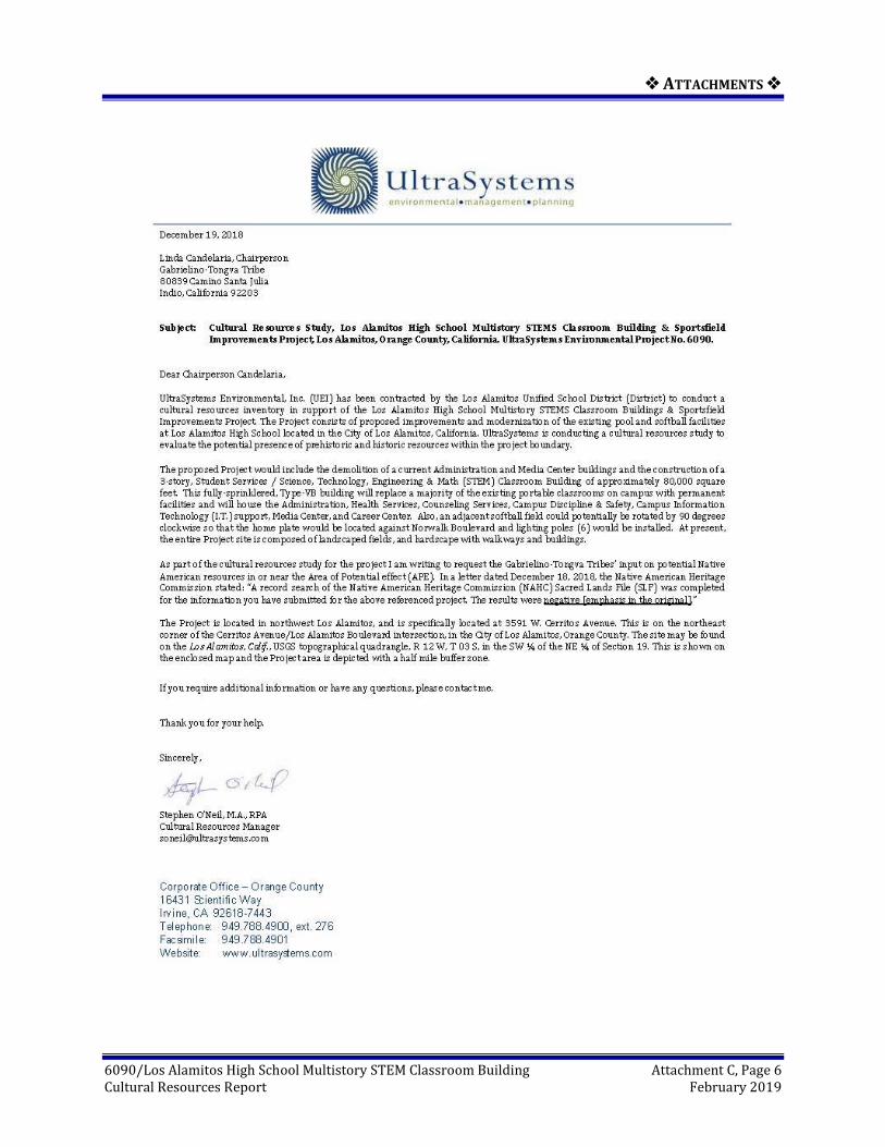
On November 30, 2018, Mr. O’Neil contacted the NAHC via email and facsimile notifying them of the project, requesting a search of their SLF and asking for a list of local tribal organizations and individuals to contact for project outreach. The results of the search request were received December 18, 2018, at the office of UEI from Ms. Katy Sanchez, Associate Governmental Planner. The NAHC letter stated that “A record search of the Native American Heritage Commission (NAHC) Sacred Lands File (SLF) was completed for the information you have submitted for the above referenced project. The results were negative [emphasis in the original].” (See Attachment C.)

❖ MANAGEMENT CONSIDERATIONS ❖
6090/Los Alamitos High School Multistory STEM Classroom Building Page 4-3 Cultural Resources Report February 2019
UEI prepared letters to each of the six tribal contacts describing the project and a map showing the project's location, requesting a reply if they have knowledge of cultural resources in the area, and asked if they had any questions or concerns regarding the project (see Attachment C). On December 19, 2018, Mr. O’Neil mailed letters with accompanying maps to all six tribal contacts, and also emailed identical letters and maps to each of the tribal contacts for which email addresses were known (6), as well as sending facsimiles on December 19, 2018 to the two tribes with facsimile capability.
There has been one direct response to date. On December 19, 2018, Mr. Andrew Salas, Chairperson of the Gabrielino Band of Mission Indians – Kizh Nation, sent an email stating that their tribe has a sacred land file adjacent to this project”; but did not state the nature or actual location of the traditional site (and the NAHC did not note a traditional site within a half-mile of the project site in its SLF). On December 21, 2018 Chairman Salas sent an email requesting that UEI provide “our Government with the lead agency’s contact information we would like to engage with consultation directly through them.” Contact information for the lead agency (the Los Alamitos Unified School District) was provided and the District was informed of Mr. Salas’ request. Brandy Salas, the Gabrielino-Kizh Nations Administrative Specialist, contacted UEI on January 4, 2019, acknowledging the letter of December 19, 2018 and stated that “If there will be any ground disturbance taking place regarding the above project our tribal government would like to consult with your lead agency.” This email was forwarded to the District (also see similar request and response from December 19, 2018 above.) On January 14, 2019, Brandy Salas also sent an email asking to be provided with the lead agency’s contact information; this information was provided to her the same day (see Attachment C). Mr. Salas did not provide any comments on the project or information on potential cultural resources at the project site or the region.
Following up on the initial letter and email contacts, telephone calls were conducted by Archaeological Technician Megan Black on January 25, 2019, to complete the outreach process following the 30-day period when replies could be made. These calls were to the five tribal contacts who had not already responded to UEI mailing and email. Two telephone calls were placed with no answer and so messages were left describing the project and requesting a response. These were to Chairperson Sandonne Goad, Chairperson of the Gabrielino/Tongva Nation; and to Mr. Charles Alvarez of the Gabrieleno-Tongva Tribe – Linda Candelaria, also representing the Gabrieleno-Tongva tribe, does not have a telephone contact number. There have been no responses to date from these tribes.
During the telephone call of January 25, 2019, Chairperson Anthony Morales of the Gabrieleno/Tongva San Gabriel Band of Mission Indians stated that he is aware of the presence of the San Gabriel River that runs close to the project site, and that the river bank, now the SR-605/San Gabriel Freeway, was a major travel and trade route. The tribe regards this area as culturally sensitive and should have both Native American and archaeological monitors present during subsurface excavation. Mr. Morales suggests that the District and/or contractor use members of the Gabrieleno/San Gabriel Band for tribal monitoring. Chairperson Robert Dorame of the Gabrielino Tongva Indians of California Tribal Council stated he would like to have the letter and map re-sent to him; following which if they have any concerns they would contact us. They do not have concerns that the project site might be a “sacred area.” The letter and map were re-sent to Mr. Dorame on January 28, 2019. There have been no further responses from these tribes to date (see Attachment C).

❖ MANAGEMENT CONSIDERATIONS ❖
6090/Los Alamitos High School Multistory STEM Classroom Building Page 4-4 Cultural Resources Report February 2019
4.3 Pedestrian Survey Results
A pedestrian survey was conducted on January 18, 2019 by Ms. Black and Ms. Lisa Ahn. The survey consisted of walking, visually inspecting, and photographing the exposed ground surface and landscaped areas of the project using standard archaeological procedures and techniques.
Survey of the ground surface was conducted in an opportunistic manner, walking transects over open space where possible across the landscaped grass area to the north and the southwest part of the project area. During the survey, the project site was carefully inspected for any indication of human activities dating to the prehistoric or historic periods (i.e., 50 years or older). Ground surface visibility was ~5%, with vegetation consisting of well-maintained lawns with multiple planters with trees. The project area has been extensively disturbed by previous grading and development activities. Because of the fully built environment of the site (Figure 4.3-1), direct observation of the ground was limited to the landscaped grass areas (Figure 4.3-2 and Figure 4.3-3), and tree planters (Figure 4.3-4) encompassing about 20% of the total surface area. A plaque located on the south side of the building indicates that the high school was dedicated in 1968 (Figure 4.3-5).
The result of the pedestrian survey was negative for both historic and prehistoric cultural resources. Photographs of the project site were taken during the cultural resources survey.

❖ MANAGEMENT CONSIDERATIONS ❖
6090/Los Alamitos High School Multistory STEM Classroom Building Page 4-5 Cultural Resources Report February 2019
Figure 4.3-1 ADMINISTRATION BUILDING, VIEW TO NORTH.

❖ MANAGEMENT CONSIDERATIONS ❖
6090/Los Alamitos High School Multistory STEM Classroom Building Page 4-6 Cultural Resources Report February 2019
Figure 4.3-2 NORTH SIDE OF THE ADMINISTRATION BUILDING; VIEW TO THE SOUTHWEST

❖ MANAGEMENT CONSIDERATIONS ❖
6090/Los Alamitos High School Multistory STEM Classroom Building Page 4-7 Cultural Resources Report February 2019
Figure 4.3-3 NORTH SIDE OF THE ADMINISTRATION BUILDING; VIEW TO THE SOUTH

❖ MANAGEMENT CONSIDERATIONS ❖
6090/Los Alamitos High School Multistory STEM Classroom Building Page 4-8 Cultural Resources Report February 2019
Figure 4.3-4 VIEW OF SOUTHWEST PORTION OF THE PROJECT AREA; VIEW TO THE SOUTHWEST

❖ MANAGEMENT CONSIDERATIONS ❖
6090/Los Alamitos High School Multistory STEM Classroom Building Page 4-9 Cultural Resources Report February 2019
Figure 4.3-5 VIEW OF THE DEDICATION PLAQUE; VIEW TO THE NORTH

❖ MANAGEMENT CONSIDERATIONS ❖
6090/Los Alamitos High School Multistory STEM Classroom Building Page 5-1 Cultural Resources Report February 2019
5.0 MANAGEMENT CONSIDERATIONS
5.1 Site Evaluation Criteria
Evaluation of significance under the California Environmental Quality Act (CEQA) uses criteria found in eligibility descriptions from the California Register of Historical Resources (CRHR). Generally, a resource is to be considered historically significant if it meets the criteria for listing in the California Register [Public Resources Code § 5024.1; California Code of Regulations § 15064.5(a)(3)]. These criteria provide that a resource may be listed as potentially significant if it:
• Is associated with the events that have made a significant contribution to the broad patterns of California history and cultural heritage.
• Is associated with the lives of persons important in our past.
• Embodies the distinctive characteristics of a type, period, region, or method of construction, or represents the work of an important creative individual, or possesses high artistic value.
• Has yielded, or may be likely to yield, information important in prehistory or history.
5.2 Potential Effects
No cultural resources will be adversely affected by the project. However, the presence of buried cultural (prehistoric and/or historic archaeological) resources cannot be ruled out. If prehistoric and/or historic artifacts are observed during subsurface excavation, work should be stopped in that area and a qualified archaeologist monitor should be called to assess the finds.

❖ CONCLUSIONS AND RECOMMENDATIONS ❖
6090/Los Alamitos High School Multistory STEM Classroom Building Page 6-1 Cultural Resources Report February 2019
6.0 CONCLUSIONS AND RECOMMENDATIONS
No prehistoric or historic archaeologic resources were identified during the pedestrian field survey of the project. The potential for subsurface cultural deposits is also minimal.
Some Native American concerns have been received to date. The Gabrieleno Band of Mission Indians-Kizh Nation indicated that they have a sacred land file adjacent to this project and that they would like to consult directly with the agency (See Section 4.2 and Attachment C). The Gabrieleno/Tongva San Gabriel Band of Mission Indians stated that they are aware of the presence of a major travel and trade route along the San Gabriel River and the SR-605/San Gabriel Freeway and believe that the area is cultural sensitive and should have both Native American and archaeological monitories present during subsurface excavation.
The cultural resources study findings suggest that there is a low potential for the presence of prehistoric cultural resources. If prehistoric and/or historic items are observed during subsurface activities, work should be stopped in that area and a qualified archaeologist and Native American monitor should be called to assess the findings and retrieve the material.
The fully built environment of the project site and elevation relative to adjacent roads suggests that ground here has been significantly cut and filled, with no native surface soil remaining. While two historic properties were identified within the half-mile buffer zone, none are within the APE, and the results of the pedestrian assessment indicate no impacts to historical resources are anticipated during project construction.
If human remains are encountered during excavations associated with this project, work will halt in that area and the Orange County Coroner will be notified (§ 5097.98 of the Public Resources Code). The Coroner will determine whether the remains are of recent human origin or older Native American ancestry. If the coroner, with the aid of the supervising archaeologist, determines that the remains are prehistoric, they will contact the NAHC. The NAHC will be responsible for designating the most likely descendant (MLD), who will make recommendations as to the manner for handling these remains and further provide for the disposition of the remains, as required by § 7050.5 of the California Health and Safety Code. Following notification by the NAHC, the MLD will make these recommendations within 48 hours of having access to the project site following notification by the NAHC. These recommendations may include scientific removal and nondestructive analysis of human remains and items associated with Native American burials (§ 7050.5 of the Health and Safety Code).

❖ REFERENCES ❖
6090/Los Alamitos High School Multistory STEM Classroom Building Page 7-1 Cultural Resources Report February 2019
7.0 REFERENCES
Anthofer, Joseph and Jeanna Regier 1998 Union Pacific Railroad Company, Abandonment and Discontinuance Exemption, in Orange
County, CA (Los Alamitos Branch) Combined Environmental and Historic Report. On file, South Central Coastal Information Center, California State University, Fullerton.
Bean, Lowell John, and Charles R. Smith 1978a Gabrielino. In Handbook of North American Indians, William C. Sturtevant, general editor,
vol. 8, California, edited by Robert F. Heizer, pp. 538-549. Smithsonian Institution, Washington, DC.
Boscana, Geronimo 1933 Chinigchinich: A Revised and Annotated Version of Alfred Robinson’s Translation of Father
Geronimo Boscana’s Historical Account of the Belief, Usages, Customs, and Extravagencies [!] of the Indians of this Mission of San Juan Capistrano Called the Acagchemem Tribe [1846]. Edited by P. T. Hanna, Annotations by John P. Harrington. Fine Arts Press, Santa Ana, California.
Chartkoff, Joseph L., and Kerry Kona Chartkoff 1984 The Archaeology of California. Stanford University Press, Stanford, California.
Chasteen, Carrie 2010a 19-189924. Newcomb Academy/3351 Val Verde Avenue, Los Angeles County. Archaeological
Site Record. On file, South Central Coastal Information Center, California State University Fullerton.
2010b 30-177412. 10821 Oak Street/Oak Middle School, Orange County. Archaeological Site Record. On file at South Central Coastal Information Center, California State University Fullerton.
2011 Historic Property Survey Report San Diego Freeway (I-405) Improvement Project, SR-73 to I-605, Orange and Los Angeles Counties. On file, South Central Coastal Information Center, California State University, Fullerton.
Demcak, Carol R. 1996 Report of Archaeological Survey from L.A. Cellular Site #85, 10652 ½ Reagan Street, Los
Alamitos, Orange County. On file, South Central Coastal Information Center, California State University, Fullerton.
Duke, Curt 2001 Cultural Resource Assessment Cingular Wireless Facility No. Sm 027-01 Orange County, CA.
On file, South Central Coastal Information Center, California State University, Fullerton.
Dumke, Glenn S. 1944 The Boom of the Eighties. Huntington Library, San Marino, California.
Engelhardt, Zephryn, O.F.M. 1931 San Gabriel Mission and the Beginnings of Los Angeles. Franciscan Herald Press, Chicago.

❖ REFERENCES ❖
6090/Los Alamitos High School Multistory STEM Classroom Building Page 7-2 Cultural Resources Report February 2019
Gold, Alan Garfinkel, Stephen O’Neil, Megan Black, Ryan Gerstner, and Varren Anacleto 2018 Final Naval Weapons Station Seal Beach Integrated Cultural Resources Management Plan.
Contract Number N62473-14-D-1414, Task Order 0006. Prepared by UltraSystems Environmental, Irvine, California. On file, Naval Weapons Station Seal Beach.
Golla, Victor 2007 Linguistic Prehistory. In California Prehistory: Colonization, Culture, and Complexity, edited by
Terry L. Jones and Kathryn A. Klar, pp. 71–82. AltaMira Press, Lanham, Maryland.
Heizer, Robert F. (editor) 1968 The Indians of Los Angeles County: Hugo Reid’s Letters of 1852. Southwest Museum Papers
No. 21. Southwest Museum, Los Angeles, California.
Howard, W. J., and L. M. Raab 1993 Olivella Grooved Rectangle Beads as Evidence of an Early Period Southern California Channel
Island Interaction Sphere. Pacific Coast Archaeological Society Quarterly 29(3):1-11.
Johnston, Bernice E. 1962 California’s Gabrielino Indians. Southwest Museum, Los Angeles.
Kroeber, Alfred 1925 Handbook of the Indians of California. Bureau of American Ethnology Bulletin No. 78,
Washington, D.C.
McCawley, William 1996 The First Angelinos: The Gabrielino Indians of Los Angeles. Malki Museum Press, Banning,
California/Ballena Press, Novato, California.
McCrea, Solomon and Barbara Wanish 2010 Geologic Compilation of Quaternary Surficial Deposits in Southern California Map Location
Calif. Onshore Portion of the Long Beach 30’ X 60’ Quadrangle. A Project for the Department of Water Resources by the California Geological Survey. Compiled from existing sources by Peter D. Roffers and Trinda L. Bedrossian, CEG. http://www.conservation.ca.gov/cgs/-fwgp/Documents/plate8_long_beach.pdf. Retrieved August 17, 2018.
McKenna, Jeanette A. 2011 A Cultural Resources Investigation of the Newcomb Academy, A Long Beach Unified School
District Campus Located at 3351 Val Verde Avenue, Long Beach, Los Angeles Co., California. On file at South Central Coastal Information Center, California State University Fullerton.
Meighan, C. W. 1954 A Late Complex in Southern California Prehistory. Southwest Journal of Anthropology
10(2):215-227.
Moratto, Michael J. 1984 California Archaeology. Academic Press, Orlando, Florida.

❖ REFERENCES ❖
6090/Los Alamitos High School Multistory STEM Classroom Building Page 7-3 Cultural Resources Report February 2019
NETR Online 2018 Aerial photographs of the project vicinity, taken in 1952, 1953, 1963, 1972, 1994, 2002, 2003,
2004, 2005, 2009, 2010, 2012, and 2014. http://www.historicaerials.com. Accessed July 2, 2018.
Porcasi, Judith F. 1998 Middle Holocene Ceramic Technology on the Southern California Coast: New Evidence from
Little Harbor, Santa Catalina Island. Journal of California and Great Basin Anthropology 20:270-284.
Rancho Los Alamitos 2018 History of the Site. https://www.rancholosalamitos.com/history.html. Retrieved August 16,
2018.
Smith, Geoffrey, M., and Pat Barker 2017 The Terminal Pleistocene/Early Holocene Record in the Northwestern Great Basin: What We
Know, What We Don’t Know, and How We May Be Wrong. http://dx.doi.org/10.108/- 20555563.2016.1272395 (Paleoamerican, Center for the Study of the First Americans, Texas A&M University). Accessed on-line at February 10, 2017.
Strawther, Larry 2012 A Brief History of Los Alamitos and Rossmoor. The History Press, Charleston, South Carolina.
Sutton, Mark Q., Mark E. Basgall, Jill K. Gardner, and Mark W. Allen 2007 Advances in Understanding Mojave Desert Prehistory. In California Prehistory: Colonization,
Culture, Complexity, edited by Terry L. Jones and Kathryn A. Klar, pp. 229-257. AltaMira Press, Lanham, Maryland.
True, Delbert L. 1958 An Early Complex in San Diego County, California. American Antiquity 23(3):255-263.
1970 Investigations of a Late Prehistoric Complex in Cuyamaca Rancho State Park, San Diego County, California. Archaeological Survey Monographs 1. University of California, Los Angeles.
Wallace, William J. 1978 Post-Pleistocene Archeology, 9,000 to 2,000 BC. In Handbook of North American Indians,
William C. Sturtevant, general editor, vol. 8, California, edited by Robert F. Heizer, pp. 25-36. Smithsonian Institution, Washington, D.C.
Warren, Claude N. 1968 Cultural Traditions and Ecological Adaptations on the Southern California Coast. In Archaic
Prehistory in Western United States, Cynthia Irwin-Williams (ed.), pp. 1-14. Eastern New Mexico University Contributions in Anthropology 1(3). Portales, New Mexico.
Warren, Claude N., and Robert H. Crabtree 1986 Prehistory of the Southwestern Area. In Warren L. D'Azevedo (ed.), Handbook of North
American Indians, Vol. 11: Great Basin, pp. 183-193. Smithsonian Institution, Washington, D.C.

❖ ATTACHMENTS ❖
6090/Los Alamitos High School Multistory STEM Classroom Building Cultural Resources Report February 2019
ATTACHMENTS

❖ ATTACHMENTS ❖
6090/Los Alamitos High School Multistory STEM Classroom Building Cultural Resources Report February 2019
ATTACHMENT A
PROJECT MAPS

❖ ATTACHMENTS❖
6090/Los Alamitos High School Multistory STEM Classroom Building Attachment A, Page 1 Cultural Resources Report February 2019
Figure 1 PROJECT REGIONAL LOCATION MAP

❖ ATTACHMENTS❖
6090/Los Alamitos High School Multistory STEM Classroom Building Attachment A, Page 2 Cultural Resources Report February 2019
Figure 2 PROJECT STUDY AREA

❖ ATTACHMENTS❖
6090/Los Alamitos High School Multistory STEM Classroom Building Attachment A, Page 3 Cultural Resources Report February 2019
Figure 3 TOPOGRAPHIC MAP WITH APE SHOWN

❖ ATTACHMENTS❖
6090/Los Alamitos High School Multistory STEM Classroom Building Cultural Resources Report February 2019
ATTACHMENT B
PERSONNEL BACKGROUND

❖ ATTACHMENTS ❖
6090/Los Alamitos High School Multistory STEM Classroom Building Attachment B, Page 1 Cultural Resources Report February 2019

❖ ATTACHMENTS ❖
6090/Los Alamitos High School Multistory STEM Classroom Building Attachment B, Page 2 Cultural Resources Report February 2019

❖ ATTACHMENTS ❖
6090/Los Alamitos High School Multistory STEM Classroom Building Attachment B, Page 3 Cultural Resources Report February 2019

❖ ATTACHMENTS ❖
6090/Los Alamitos High School Multistory STEM Classroom Building Attachment B, Page 4 Cultural Resources Report February 2019

❖ ATTACHMENTS ❖
6090/Los Alamitos High School Multistory STEM Classroom Building Attachment B, Page 5 Cultural Resources Report February 2019

❖ ATTACHMENTS ❖
6090/Los Alamitos High School Multistory STEM Classroom Building Cultural Resources Report February 2019
ATTACHMENT C
Native American Heritage Commission Records
Search and Native American Contacts

❖ ATTACHMENTS ❖
6090/Los Alamitos High School Multistory STEM Classroom Building Attachment C, Page 1 Cultural Resources Report February 2019

❖ ATTACHMENTS ❖
6090/Los Alamitos High School Multistory STEM Classroom Building Attachment C, Page 2 Cultural Resources Report February 2019

❖ ATTACHMENTS ❖
6090/Los Alamitos High School Multistory STEM Classroom Building Attachment C, Page 3 Cultural Resources Report February 2019

❖ ATTACHMENTS ❖
6090/Los Alamitos High School Multistory STEM Classroom Building Attachment C, Page 4 Cultural Resources Report February 2019

❖ ATTACHMENTS ❖
6090/Los Alamitos High School Multistory STEM Classroom Building Attachment C, Page 5 Cultural Resources Report February 2019
❖ ATTACHMENTS ❖
6090/Los Alamitos High School Multistory STEM Classroom Building Attachment C, Page 6 Cultural Resources Report February 2019

❖ ATTACHMENTS ❖
6090/Los Alamitos High School Multistory STEM Classroom Building Attachment C, Page 7 Cultural Resources Report February 2019

❖ ATTACHMENTS ❖
6090/Los Alamitos High School Multistory STEM Classroom Building Attachment C, Page 8 Cultural Resources Report February 2019

❖ ATTACHMENTS ❖
6090/Los Alamitos High School Multistory STEM Classroom Building Attachment C, Page 9 Cultural Resources Report February 2019

❖ ATTACHMENTS ❖
6090/Los Alamitos High School Multistory STEM Classroom Building Attachment C, Page 10 Cultural Resources Report February 2019

❖ ATTACHMENTS ❖
6090/Los Alamitos High School Multistory STEM Classroom Building Attachment C, Page 11 Cultural Resources Report February 2019

❖ ATTACHMENTS ❖
6090/Los Alamitos High School Multistory STEM Classroom Building Attachment C, Page 12 Cultural Resources Report February 2019

❖ ATTACHMENTS ❖
6090/Los Alamitos High School Multistory STEM Classroom Building Attachment C, Page 13 Cultural Resources Report February 2019

❖ ATTACHMENTS ❖
6090/Los Alamitos High School Multistory STEM Classroom Building Attachment C, Page 14 Cultural Resources Report February 2019

❖ ATTACHMENTS ❖
6090/Los Alamitos High School Multistory STEM Classroom Building Attachment C, Page 15 Cultural Resources Report February 2019

❖ ATTACHMENTS ❖
6090/Los Alamitos High School Multistory STEM Classroom Building Attachment C, Page 16 Cultural Resources Report February 2019

❖ ATTACHMENTS ❖
6090/Los Alamitos High School Multistory STEM Classroom Building Attachment C, Page 17 Cultural Resources Report February 2019

❖ ATTACHMENTS ❖
6090/Los Alamitos High School Multistory STEM Classroom Building Attachment C, Page 18 Cultural Resource Report February 2019
City of Los Alamitos – Multi-Story Building, Orange County, California. [UEI #6090]
Native American Contact Log
Name Tribe/Affil
iation
Letter and Fax Contacts
E-mail Contacts
Telephone Contact
Comments
Frank Lienert, Asst. Governmental Program Analyst
Native American Heritage Commission
November 30, 2018 (Fax)
November 30, 2018; December 7, 2018.
N/A Request for Sacred Lands File search and local Native American representatives contact information.
Andrew Salas, Chairperson
Gabrieleno Band of Mission Indians - Kizh Nation
December 19, 2018 (letter)
December 19, 2018; December 20, 2018; December 21, 2018 (email)
N/A Letter, email and fax describing project and requesting input on concerns was sent December 19, 2018. Email response was received on December 19 &21. 2018, from Andy Salas asking for the lead agency’s contact information so that they can consult directly with the city.
Anthony Morales, Chairperson
Gabrieleno/ Tongva San Gabriel Band of Mission Indians
December 19, 2018 (letter & fax)
December 19, 2018 (email)
Telephone call made January 26, 2019
Letter, fax and email describing project and requesting input on concerns was sent December 19, 2018. Phone call was made January 26, 2019 and Morales indicated that due to the projects vicinity to water sources and major travel routes he would consider this area sensitive for resources. He recommended the use of archeological and Native American monitors
Sandonne Goad, Chairperson
Gabrielino /Tongva Nation
December 19, 2018 (letter)
December 19, 2018 (email)
Telephone call made January 26, 2019
Letter and email describing project and requesting input on concerns was sent December 19, 2018. Phone call was made January 26, 2019. There was no answer, a message was left. No response to date.
Robert Dorame, Chairman
Gabrielino - Tongva Indians of California Tribal Council
December 19, 2018 (letter & fax)
December 19, 2018; January 25 & 28, 2019 (email)
Telephone call made January 26, 2019
Letter, fax and email describing project and requesting input on concerns was sent December 19, 2018. Phone call was made January 25, 2019 and Dorame asked if we would resend the material over email. He instructed that he will review the information and they will get back to us if they have any concerns. If they don’t get back to us then that don’t have any concerns that it’s a sacred area.
Linda Candelaria, Chairperson
Gabrielino - Tongva Tribe
December 19, 2018 (letter & fax)
December 19, 2018 (email)
No phone number provided.
Letter and email describing project and requesting input on concerns was sent December 19, 2018. No phone call was made as no phone number was provided. No response to date.

❖ ATTACHMENTS ❖
6090/Los Alamitos High School Multistory STEM Classroom Building Attachment C, Page 19 Cultural Resource Report February 2019
Name Tribe/Affil
iation
Letter and Fax Contacts
E-mail Contacts
Telephone Contact
Comments
Charles Alvarez, Councilmember
Gabrielino - Tongva Tribe
December 19, 2018 (letter)
December 19, 2018 (email)
Telephone call made January 26, 2019
Letter and email describing project and requesting input on concerns was sent December 19, 2018. Phone call was made January 26, 2019. There was no answer, a message was left. No response to date.

❖ ATTACHMENTS ❖
6090/Los Alamitos High School Multistory STEM Classroom Building Cultural Resource Report February 2019
ATTACHMENT D
CHRIS Records Search Bibliography

❖ ATTACHMENTS ❖
6090/Los Alamitos High School Multistory STEM Classroom Building Attachment D, Page 1 Cultural Resources Report February 2019