appendix b4 - construction soil and water quality ... · whytes lane to pimlico road early works...
TRANSCRIPT
APPENDIX B4
Construction Soil and Water Quality Management Plan
Whytes Lane to Pimlico Road Early Works – Wave 2
Pacific Highway Upgrade OCTOBER 2015
Whytes Lane to Pimlico Road Early Works – Wave 2
Construction Soil and Water Quality Management Plan i
Document control
File name 05-A1-00-B4_W2B Wave2_Appendix B4_Rev6
Report name Whytes Lane to Pimlico Road Early Works – Wave 2 Construction Soil and Water Quality Management Plan
Revision number 6
Plan approved by: [signed]
[signed]
[signed]
Name
Name
Name
Contractor PM
Contractor EM
RMS representative
Revision history Revision Date Description Approval
6 20/10/2015 For Approval Ryan Buckley – SEE Civil
5 20/10/2015 Incorporating agency comments Ryan Buckley – SEE Civil
4 16/09/2015 Incorporating Agency Comments (EPA)
Ryan Buckley – SEE Civil
3 08/09/2015 For Agency Review Ryan Buckley – SEE Civil
2 20/08/2015 For RMS Review Ryan Buckley – SEE Civil
1 23/07/2015 For RMS Review Ryan Buckley – SEE Civil
0 08/07/2015 Initial for review Carly McCormack – SMEC
Distribution of controlled copies Copy no. Issued to Version
1
2
3

Whytes Lane to Pimlico Road Early Works – Wave 2
Construction Soil and Water Quality Management Plan ii
4
5
Whytes Lane to Pimlico Road Early Works – Wave 2
Construction Soil and Water Quality Management Plan iii
Contents 1 Introduction ......................................................................................................................1
1.1 Context ....................................................................................................................1
1.2 Background..............................................................................................................1
1.3 Environmental management systems overview........................................................1
2 Purpose and objectives ....................................................................................................3
2.1 Purpose ...................................................................................................................3
2.2 Objectives ................................................................................................................3
2.3 Targets ....................................................................................................................3
3 Environmental requirements .............................................................................................4
3.1 Relevant legislation and guidelines ..........................................................................4
3.2 Minister’s Conditions of Approval .............................................................................5
4 Existing environment ......................................................................................................11
4.1 Topography and soil characteristics .......................................................................11
4.2 Surface water .........................................................................................................12
4.3 Groundwater ..........................................................................................................13
4.4 Rainfall ...................................................................................................................13
4.5 Flooding .................................................................................................................14
5 Environmental aspects and impacts ...............................................................................16
5.1 Construction activities ............................................................................................16
5.2 Potential Impacts ...................................................................................................16
6 Environmental control measures ....................................................................................18
7 Compliance management...............................................................................................40
7.1 Roles and responsibilities ......................................................................................40
7.2 Training ..................................................................................................................40
7.3 Monitoring and inspection ......................................................................................40
7.4 Licenses and permits .............................................................................................41
7.5 Weather monitoring ................................................................................................41
7.6 Auditing ..................................................................................................................42
7.7 Reporting ...............................................................................................................42
8 Review and improvement ...............................................................................................43
8.1 Continuous improvement .......................................................................................43
8.2 CSWQMP update and amendment ........................................................................43
Tables
Table 3-1 Conditions of Approval relevant to the CSWQMP ...................................................5 Table 4-1 Summary of rainfall records.................................................................................13 Table 6-1 Soil and water management and mitigation measures ........................................19 Table 7-1 Discharge water quality criteria ...........................................................................41
Whytes Lane to Pimlico Road Early Works – Wave 2
Construction Soil and Water Quality Management Plan iv
Appendices
Appendix A Water Quality Monitoring Program Appendix B Spoil and Fill Management Procedure Appendix C Acid Sulfate Soil Management Procedure Appendix D Management of Tannins from Vegetation Mulch Appendix E Groundwater Management Strategy Appendix F Unexpected Discovery of Contaminated Land Procedure Appendix G Pacific Highway Projects Dewatering Practice Note Appendix H Sediment Basin Management and Discharge Procedure Appendix I Stockpile Management Protocol Appendix J Emergency Spill Response Plan Appendix K Groundwater and Soil Salinity Report Appendix L Oxleyan Pygmy Perch Habitat Waterway Management Framework Appendix M Hydrological Mitigation Report Appendix N Schedule of property specific management measures

Whytes Lane to Pimlico Road Early Works – Wave 2
Construction Soil and Water Quality Management Plan v
Glossary / Abbreviations ASMMP Acid Sulfate Material Management Plan
CEMP Construction Environmental Management Plan
CLMP Contaminated Land Management Plan
CoA Condition of Approval
DECC Former Department of Environment and Climate Change (NSW) now NSW Office of Environment and Heritage.
DP&E NSW Department of Planning and Environment
DPI NSW Department of Primary Industries (Fishing and Aquaculture)
EEC Endangered Ecological Community
EIS Woolgoolga to Ballina Pacific Highway Upgrade Environmental Impact Statement (December, 2012)
EPA NSW Environment Protection Authority
EP&A Act NSW Environmental Planning and Assessment Act 1979
EPL NSW Environment Protection Licence under the Protection of the Environment Operations Act 1997.
ESCP Erosion and Sediment Control Plan
EWMS Environmental Work Method Statements
FM Act NSW Fisheries Management Act 1994
Minister, the NSW Minister for Planning
DPI Water NSW DPI Water
OEH NSW Office of Environment and Heritage
PoEO Act NSW Protection of the Environment Operations Act 1997
Project, the Whytes Lane to Pimlico Road Early Works – Wave 2
SEE Civil SEE Civil Pty Ltd
SPIR Submissions / Preferred Infrastructure Report

Whytes Lane to Pimlico Road Early Works – Wave 2Construction Soil and Water Quality Management Plan 1
1 Introduction
1.1 Context
This Construction Soil and Water Quality Management Plan (CSWQMP or Plan) forms part of the Construction Environmental Management Plan (CEMP) for the Whytes Lane to Pimlico Road Early Works – Wave 2 (the Project), which forms part of the upgrade project to the Pacific Highway between Woolgoolga and Ballina. SEE Civil have been nominated as the construction contractor for Wave 2.
This CSWQMP has been prepared to address the requirements of the Minister’s Conditions of Approval (CoA) and the mitigation measures listed in the Pacific Highway Upgrade Woolgoolga to Ballina Environmental Impact Statement (EIS), Submissions / Preferred Infrastructure Report (SPIR) and all applicable legislation. This plan will be finalised and updated by the successful construction contractor (SEE Civil).
There are four tie-in projects within the Woolgoolga to Ballina project limits, namely Sapphire to Woolgoolga, Glenugie Upgrade, Devils Pulpit and the Ballina Bypass projects. These tie-in projects have been approved separately by the Minister. Relevant conditions of approval for these projects have been referenced in the Whytes Lane to Pimlico Road Early Works – Wave 2 CEMP and plans as appropriate
The Project is located within Section 11 of the Woolgoolga to Ballina Pacific Highway Upgrade. Wave 2 of the Early Works (soft soil treatments) is to allow the future upgrade of the section of HW10 Pacific Highway, Woolgoolga to Ballina. Due to Project’s location, the majority of fill material used for in the construction of the highway will be imported with only a minor volume of spoil generated. The Project specifically covers the following soft soil as detailed below:
Soft Soil Site 11 – between Whytes Lane and Pimlico Road (W2P) (STN 159,900 to STN 163,800).
SEE Civil have been nominated as the construction contractor for Wave 2 Early Works.
1.2 Background
The Pacific Highway Upgrade Woolgoolga to Ballina EIS (RMS 2012) assessed the impacts of construction and operation of the Project on soils and water, within Chapters 8 and 9.
As part of the EIS development, detailed groundwater and water quality assessments were prepared to address the Environmental Assessment Requirements issued by the Department of Planning and Environment. These assessments were included in the EIS as Working Paper: Water Quality, Working Paper: Hydrology and Flooding and Working Paper: Groundwater.
The EIS identified the potential for direct and indirect impacts on water quality but concluded that, with implementation of appropriate impact mitigation measures, there would be no significant impacts to waterways crossed by the project, or to high risk areas or sensitive receiving environments downstream of the project.
Additional management measures were provided within the Woolgoolga to Ballina Submissions / Preferred Infrastructure Report Nov 2013, with applicable management
measures from that report included as part of this CSWQMP.
1.3 Environmental management systems overview
The overall Environmental Management System for the Project is described in the Construction Environmental Management Plan (CEMP).

Whytes Lane to Pimlico Road Early Works – Wave 2
Construction Soil and Water Quality Management Plan 2
The CSWQMP is part of the SEE Civil environmental management framework for the Project, as described in Section 4.1 of the CEMP. In accordance with CoA D25 (c), this Plan has been developed in consultation with the EPA, DPI (Fisheries NSW), DPI WATER and Ballina Shire Council.
Management measures identified in this Plan will be incorporated into site or activity specific Environmental Work Method Statements (EWMS) and Erosion and Sediment Control Plans (ESCP).
EWMS will be developed and signed off by environment and management representatives prior to associated works and construction personnel will be required to undertake works in accordance with the identified safeguards. For high risk activities, such as construction of working platforms in waterways, EWMS will be provided to EPA and DPI Fisheries Conservation and Aquaculture for input prior to sign off (refer to Section 4.1.3 of the CEMP).
ESCP are designed for use as a practical guide and may be produced in conjunction with EWMS to provide more detailed site-specific environmental mitigation measures. ESCP will be developed by the environment team in consultation with construction personnel and the Project Soil Conservationist, and modified as required when:
Site conditions evolve.
Flow paths change.
Construction activities that affected the characteristics of ground conditions change.
Used together, the CEMP, strategies, procedures, EWMS and ESCP form management guides that clearly identify required environmental management actions for reference by SEE Civil personnel and sub-contractors.
The review and document control processes for this Plan are described in Sections 9 and 10 of the CEMP.
Whytes Lane to Pimlico Road Early Works – Wave 2Construction Soil and Water Quality Management Plan 3
2 Purpose and objectives
2.1 Purpose
The purpose of this Plan is to describe how construction impacts on soil and water will be minimised and managed.
2.2 Objectives
The key objective of the CSWQMP is to ensure that impacts on soil and water quality are minimised and within the scope permitted by the planning approval. To achieve this objective, SEE Civil will undertake the following:
Ensure best management practice controls and procedures are implemented during construction activities to avoid or minimise erosion/sedimentation impacts and potential impacts to water quality in rivers, creeks and groundwater along the Project corridor.
Ensure appropriate measures are implemented to address the relevant CoA outlined in Table 3.1 and the safeguards detailed in the EIS and Submission / Preferred Infrastructure Report (SPIR).
Ensure appropriate measures are implemented to comply with all relevant legislation and other requirements as described in Section 3.1 of this Plan.
2.3 Targets
The following targets have been established for the management of soil and water impacts during the project:
Ensure full compliance with the relevant legislative requirements and CoA.
Meet environmental protection licence water quality discharge parameters for all planned basin discharges (i.e. those within design capacity).
Manage downstream water quality impacts attributable to the project (i.e. maintain waterway health by avoiding the introduction of nutrients, sediment and chemicals outside of that permitted by the environmental protection licence and/or ANZECC guidelines).
Ensure training on best practice soil and water management is provided to all construction personnel through site inductions.
Whytes Lane to Pimlico Road Early Works – Wave 2Construction Soil and Water Quality Management Plan 4
3 Environmental requirements
3.1 Relevant legislation and guidelines
3.1.1 Legislation
Legislation relevant to soil and water management includes:
Environmental Planning and Assessment Act 1979 (EP&A Act).
Environmental Planning and Assessment Regulation 2000.
Protection of the Environment Operations Act 1997.
Water Management Act 2000.
Fisheries Management Act 1994.
Commonwealth Environment Protection and Biodiversity Conservation Act 1999.
Water Act 1912.
Relevant provisions of the above legislation are explained in the register of legal and other requirements included in Appendix A1 of the CEMP.
3.1.2 Guidelines and standards
The main guidelines, specifications and policy documents relevant to this Plan include:
Acid Sulfate Soil Manual (ASSMAC 1998).
Acid Sulfate Soil and Rock – Victorian EPA Publication 655.1 – July 2009.
Australian and New Zealand Guidelines for Fresh and Marine Water Quality (ANZECC and ARMCANZ 2000).
Department of Environment and Conservation (DEC): Bunding & Spill Management. Insert to the Environment Protection Manual for Authorised Officers - Technical section "Bu" November 1997.
Managing Urban Stormwater: Soils and Construction. Landcom, (4th Edition) March 2004 (reprinted 2006) (the “Blue Book”). Volume 1 and Volume 2.
Volume 2A Installation of Services (DECCW 2008).
Volume 2C Unsealed Roads (DECCW 2008).
Volume 2D Main Roads Construction (DECCW 2008).
DIPNR Roads and Salinity Guideline, 2003.
DLWC, 1998. Constructed Wetlands Manual.
Fairfull, S. and Witheridge, G. (2003) Why do Fish Need to Cross the Road? Fish Passage Requirements for Waterway Crossings. NSW Fisheries, Cronulla, 16 pp.
NSW Fisheries, November 2003. Fishnote – Policy and Guidelines for Fish Friendly Waterway Crossings (Ref: NSWF – 1181).
RMS Dewatering Guideline.
RMS Pacific Highway Practice Note for Dewatering.
RTA’s Code of Practice for Water Management – Road Development and Management (1999).
Whytes Lane to Pimlico Road Early Works – Wave 2
Construction Soil and Water Quality Management Plan 5
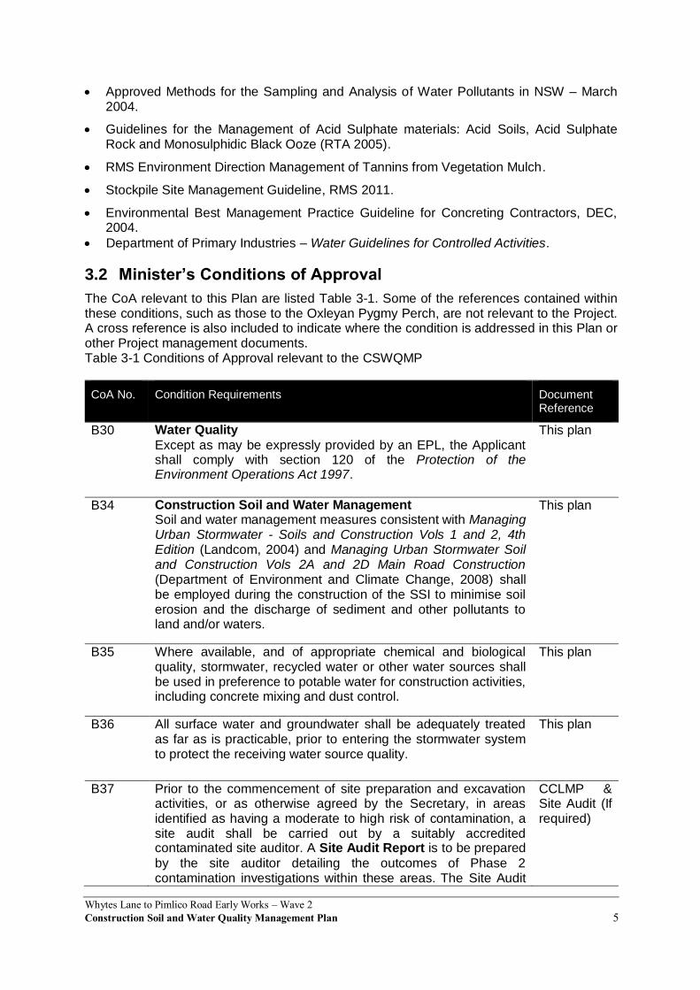
Approved Methods for the Sampling and Analysis of Water Pollutants in NSW – March 2004.
Guidelines for the Management of Acid Sulphate materials: Acid Soils, Acid Sulphate Rock and Monosulphidic Black Ooze (RTA 2005).
RMS Environment Direction Management of Tannins from Vegetation Mulch.
Stockpile Site Management Guideline, RMS 2011.
Environmental Best Management Practice Guideline for Concreting Contractors, DEC, 2004.
Department of Primary Industries – Water Guidelines for Controlled Activities.
3.2 Minister’s Conditions of Approval
The CoA relevant to this Plan are listed Table 3-1. Some of the references contained within these conditions, such as those to the Oxleyan Pygmy Perch, are not relevant to the Project. A cross reference is also included to indicate where the condition is addressed in this Plan or other Project management documents. Table 3-1 Conditions of Approval relevant to the CSWQMP
CoA No. Condition Requirements Document Reference
B30 Water Quality
Except as may be expressly provided by an EPL, the Applicant shall comply with section 120 of the Protection of the Environment Operations Act 1997.
This plan
B34 Construction Soil and Water Management Soil and water management measures consistent with Managing Urban Stormwater - Soils and Construction Vols 1 and 2, 4th Edition (Landcom, 2004) and Managing Urban Stormwater Soil and Construction Vols 2A and 2D Main Road Construction (Department of Environment and Climate Change, 2008) shall be employed during the construction of the SSI to minimise soil erosion and the discharge of sediment and other pollutants to land and/or waters.
This plan
B35 Where available, and of appropriate chemical and biological quality, stormwater, recycled water or other water sources shall be used in preference to potable water for construction activities, including concrete mixing and dust control.
This plan
B36 All surface water and groundwater shall be adequately treated as far as is practicable, prior to entering the stormwater system to protect the receiving water source quality.
This plan
B37 Prior to the commencement of site preparation and excavation activities, or as otherwise agreed by the Secretary, in areas identified as having a moderate to high risk of contamination, a site audit shall be carried out by a suitably accredited contaminated site auditor. A Site Audit Report is to be prepared
by the site auditor detailing the outcomes of Phase 2 contamination investigations within these areas. The Site Audit
CCLMP & Site Audit (If required)

Whytes Lane to Pimlico Road Early Works – Wave 2
Construction Soil and Water Quality Management Plan 6
CoA No. Condition Requirements Document Reference
Report shall detail, where relevant, whether the land is suitable (for the intended land use) or can be made suitable through remediation. Where the investigations identify that the site is suitable for the intended operations and that there is no need for a specific remediation strategy, measures to identify, handle and manage potential contaminated soils, materials and groundwater shall be identified in the Site Audit Report and incorporated into the Construction Environmental Management Plan. Where the investigations identify that the site is suitable for the intended operations and that a remediation strategy is required, the Site Audit Report shall include a remediation strategy for addressing the site contamination, and how the environmental and human health risks will be managed during the disturbance, remediation and/or removal of contaminated soil or groundwater, and be incorporated into the Construction Environmental Management Plan. Where remediation is required, a Site Audit Statement(s) shall
be prepared verifying that the site has been remediated to a standard consistent with the intended land use. Note Terms used in this condition have the same meaning as in the Contaminated Land Management Act 1997.
B38 Watercourse crossings
Watercourse crossings shall be designed in consultation with the DPI (Fisheries NSW), EPA, DPI WATER and DoE, and where feasible and reasonable, be consistent with the Guidelines for Controlled Activities Watercourse Crossings (Department of Water and Energy, February 2008), Why do Fish Need to Cross the Road? Fish Passage Requirements for Waterway Crossings (Fairfull and Witheridge, 2003), Policy and Guidelines for Fish Friendly Waterway Crossings (NSW Fisheries, February 2004), and Policy and Guidelines for Fish Habitat Conservation and Management (DPI Fisheries, 2013). Where multiple cell culverts
are proposed for crossings of fish habitat streams, at least one cell shall be provided for fish passage, with an invert or bed level that mimics watercourse flows.
This plan
D12 The Applicant shall prepare and implement a Water Quality Monitoring Program, to monitor the construction and operation impacts of the SSI on surface and groundwater quality and resources and wetlands, prior to construction. The Program shall be prepared in consultation with the OEH, EPA, DPI (Fisheries), DPI WATER, DoE and Rous Water (in relation to the Woodburn borefields), to the satisfaction of the Secretary, and shall include but not necessarily be limited to:
(a) identification of surface and groundwater quality monitoring locations (including watercourses, waterbodies and SEPP14 wetlands) which are
Appendix A

Whytes Lane to Pimlico Road Early Works – Wave 2
Construction Soil and Water Quality Management Plan 7
CoA No. Condition Requirements Document Reference
representative of the potential extent of impacts from the SSI;
(b) the results of any groundwater modelling undertaken;
(c) identification of works and activities during construction and operation of the SSI, including emergencies and spill events, that have the potential to impact on surface water quality of potentially affected waterways and known Oxleyan Pygmy Perch habitat;
(d) development and presentation of parameters and standards against which any changes to water quality will be assessed, having regard to the Australian and New Zealand Guidelines for Fresh and Marine Water Quality 2000 (Australian and New
Zealand Environment Conservation Council, 2000) or relevant baseline data;
(e) representative background monitoring of surface and groundwater quality parameters for a minimum of twelve months (considering seasonality) prior to the commencement of construction, to establish baseline water conditions, unless otherwise agreed by the Secretary;
(f) a minimum monitoring period of three years following the completion of construction or until the affected waterways and/or groundwater resources are certified by an independent expert as being rehabilitated to an acceptable condition. The monitoring shall also confirm the establishment of operational water control measures (such as sedimentation basins and vegetation swales);
(g) contingency and ameliorative measures in the event that adverse impacts to water quality are identified; and
(h) reporting of the monitoring results to Department of Planning and Environment, OEH, EPA, DPI (Fisheries), DPI WATER, DoE and Rous Water (in relation to the Woodburn borefields).
D13 The Applicant shall prepare and implement a Hydrological Mitigation Report for properties where flooding and/or hydrological impacts are predicted to exceed the relevant flood management objective in the documents listed in condition A2 as a result of the SSI. The Report shall be prepared by a suitably qualified expert and be based on detailed surveys (e.g. floor levels) and associated assessment of potentially flood affected properties in the Corindi, Clarence and Richmond river floodplains. The Report shall:
(a) identify properties in those areas likely to have an increased/exacerbated impact and detail the predicted impact; The types of impacts to be
Appendix M
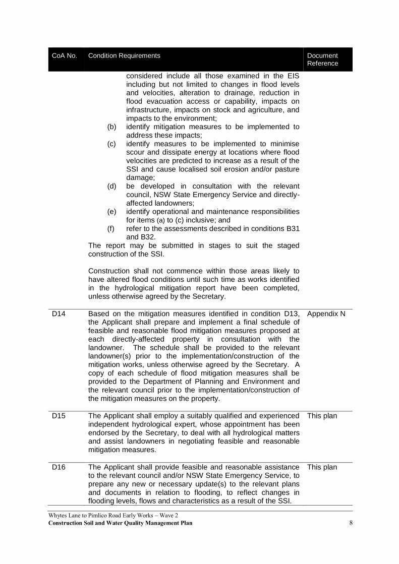
Whytes Lane to Pimlico Road Early Works – Wave 2
Construction Soil and Water Quality Management Plan 8
CoA No. Condition Requirements Document Reference
considered include all those examined in the EIS including but not limited to changes in flood levels and velocities, alteration to drainage, reduction in flood evacuation access or capability, impacts on infrastructure, impacts on stock and agriculture, and impacts to the environment;
(b) identify mitigation measures to be implemented to address these impacts;
(c) identify measures to be implemented to minimise scour and dissipate energy at locations where flood velocities are predicted to increase as a result of the SSI and cause localised soil erosion and/or pasture damage;
(d) be developed in consultation with the relevant council, NSW State Emergency Service and directly-affected landowners;
(e) identify operational and maintenance responsibilities for items (a) to (c) inclusive; and
(f) refer to the assessments described in conditions B31 and B32.
The report may be submitted in stages to suit the staged construction of the SSI.
Construction shall not commence within those areas likely to have altered flood conditions until such time as works identified in the hydrological mitigation report have been completed, unless otherwise agreed by the Secretary.
D14 Based on the mitigation measures identified in condition D13, the Applicant shall prepare and implement a final schedule of feasible and reasonable flood mitigation measures proposed at each directly-affected property in consultation with the landowner. The schedule shall be provided to the relevant landowner(s) prior to the implementation/construction of the mitigation works, unless otherwise agreed by the Secretary. A copy of each schedule of flood mitigation measures shall be provided to the Department of Planning and Environment and the relevant council prior to the implementation/construction of the mitigation measures on the property.
Appendix N
D15 The Applicant shall employ a suitably qualified and experienced independent hydrological expert, whose appointment has been endorsed by the Secretary, to deal with all hydrological matters and assist landowners in negotiating feasible and reasonable mitigation measures.
This plan
D16 The Applicant shall provide feasible and reasonable assistance to the relevant council and/or NSW State Emergency Service, to prepare any new or necessary update(s) to the relevant plans and documents in relation to flooding, to reflect changes in flooding levels, flows and characteristics as a result of the SSI.
This plan
Whytes Lane to Pimlico Road Early Works – Wave 2
Construction Soil and Water Quality Management Plan 9
CoA No. Condition Requirements Document Reference
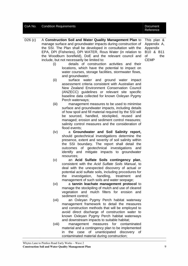
D26 (c) A Construction Soil and Water Quality Management Plan to manage surface and groundwater impacts during construction of the SSI. The Plan shall be developed in consultation with the EPA, DPI (Fisheries), DPI WATER, Rous Water (in relation to the Woodburn borefield), DoE and the relevant council and include, but not necessarily be limited to:
(i) details of construction activities and their locations, which have the potential to impact on water courses, storage facilities, stormwater flows, and groundwater;
(ii) surface water and ground water impact assessment criteria consistent with Australian and New Zealand Environment Conservation Council (ANZECC) guidelines or relevant site specific baseline data collected for known Oxleyan Pygmy Perch waterways;
(iii) management measures to be used to minimise surface and groundwater impacts, including details of how spoil and fill material required by the SSI will be sourced, handled, stockpiled, reused and managed; erosion and sediment control measures; salinity control measures and the consideration of flood events;
(iv) a Groundwater and Soil Salinity report,
should geotechnical investigations determine the presence, extent and severity of soil salinity within the SSI boundary. The report shall detail the outcomes of geotechnical investigations and identify and mitigate impacts to groundwater resources;
(v) an Acid Sulfate Soils contingency plan, consistent with the Acid Sulfate Soils Manual, to deal with the unexpected discovery of actual or potential acid sulfate soils, including procedures for the investigation, handling, treatment and management of such soils and water seepage;
(vi) a tannin leachate management protocol to
manage the stockpiling of mulch and use of cleared vegetation and mulch filters for erosion and sediment control;
(vii) an Oxleyan Pygmy Perch habitat waterway management framework to detail the measures and construction methods that will be employed to avoid direct discharge of construction water to known Oxleyan Pygmy Perch habitat waterways and downstream impacts to suitable habitat;
(viii) management measures for contaminated material and a contingency plan to be implemented in the case of unanticipated discovery of contaminated material during construction;
This plan & Appendix A, Appendix B10 & B11 of the CEMP

Whytes Lane to Pimlico Road Early Works – Wave 2
Construction Soil and Water Quality Management Plan 10
CoA No. Condition Requirements Document Reference
(ix) a description of how the effectiveness of these actions and measures would be monitored during the proposed works, clearly indicating how often this monitoring would be undertaken, the locations where monitoring would take place, how the results of the monitoring would be recorded and reported, and, if any exceedance of the criteria is detected how any non-compliance can be rectified; and mechanisms for the monitoring, review and amendment of this plan.
Whytes Lane to Pimlico Road Early Works – Wave 2Construction Soil and Water Quality Management Plan 11
4 Existing environment The following sections summarise what is known about factors influencing soils and water within and adjacent to the Project corridor.
The key reference documents are Chapters 8 and 9 of the EIS, Working Paper: Water Quality, Working Paper: Hydrology and Flooding and Working Paper: Groundwater.
4.1 Topography and soil characteristics
The topography throughout the Project is variable but can be broadly categorised as ‘lowland’. Lowland areas are predominately associated with the Clarence and Richmond river floodplains and occur where elevations are less than about 15 m AHD. This is the dominant landform within Section 11 of the Pacific Highway Upgrade between Woolgoolga and Ballina, with the Richmond River floodplain existing between Coolgardie (to the south) and Emigrant Creek (to the north), bounded by the Blackwall Range to the west. The overall upgrade Project generally traverses the geological sequence of the Clarence-Moreton Basin, an extensive Mesozoic age sedimentary basin extending from southern Queensland to the NSW North Coast and comprising sedimentary rocks about 2.5 to 4 km thick. Both the northern and southern extents of the Pacific Highway Upgrade project extend beyond the sedimentary basin, with the underlying Palaeozoic basement rocks of the New England Fold Belt outcropping at Woolgoolga and Ballina.
As Section 11 consists of a relatively flat, low lying area; slope stability issues are not considered to be a likely concern.
However, the most common soil landscape within Section 11 is alluvial soils. These are typically highly acidic, highly erodible, of low bearing strength and subject to flood hazards. Consequently, the presence of acid sulfate soils (ASS) or potential acid sulfate soils (PASS) is a key consideration for the Project.
Topography and soils for Section 11 of the Project are also outlined in Table 4-1. Table 4-1 Topography and soils
Section Topography Soil type Soil characteristics
11 Lowland Mainly underlain by alluvial landscapes.
Estuarine landscapes are located at the north, typically west of Emigrant Creek.
Highly erodible.
Prone to water erosion.
PASS contain iron sulfides (pyrites), which may oxidise when exposed to air, resulting in soil acidification and dissolved acid and metal discharge into nearby surface water bodies via surface water runoff and groundwater flows. Soil acidification and dissolved acid runoff can result in detrimental impacts on the health of land and aquatic plants and animals. The acid sulfate soil analyses in the EIS indicated that both actual and potential acid sulfate soils are present, including broad areas of high risk acid sulfate soils and some areas of low risk acid sulfate soils (see Appendix A5 of the CEMP). The EIS has identified that Section 11 has a high probability of acid sulfate soils occurring within one to 3 m below ground level. Since the acid neutralising capacity of the soils is insufficient to neutralise the total potential acidity present in the soils, appropriate acid Sulfate soil management practices will be required. This is addressed further in Chapter 6. Contamination
Information on contamination, as presented in the EIS, was obtained from preliminary site contamination studies carried out for previous project development phases and a follow-up assessment of contamination carried out in 2012. The previous studies were carried out
Whytes Lane to Pimlico Road Early Works – Wave 2
Construction Soil and Water Quality Management Plan 12
between 2005 and 2010 and involved identifying potential contamination based on past and present land uses, using a combination of aerial photographs, historical records and visual site inspections. Limited sampling and laboratory testing of surface soils was carried out at a selection of locations where contamination was considered to have the potential to occur.
The follow-up assessment of contamination carried out in 2012 involved a review of the results of previous studies and existing contamination databases, and a site inspection of accessible areas of interest to verify locations of potential contamination. An assessment of contamination risks was carried out, taking into consideration the proximity of potentially contaminated areas to the project boundary, the likelihood of exposure of contamination during project construction, and the potential consequences of disturbance and exposure of contaminants.
The EIS identifies only one area (Figure 9-22 in the EIS) that potentially contains contamination within Section 11. This area is located approximately 500 m away from the southern-most extent of the Project boundary. As such, there are no areas of contamination (identified as ‘potential areas of environmental concern’) located within the Project boundary.
SEE Civil has prepared a Construction Contaminated Land Management Plan (CCLMP) as part of the CEMP (Appendix B10). It includes an Unexpected Discovery of Contaminated Land Procedure.
4.2 Surface water
The Pacific Highway Upgrade project crosses various waterways, including the major Clarence and Richmond river systems. These include freshwater systems and estuarine systems, and some of the receiving waters drain to or support sensitive aquatic and riparian environments including key fish habitats and wetlands listed under SEPP 14.
Small creeks and drainage lines cross the Project area. Notably, the EIS highlights that there are indicative riparian zones located at the northern and southern end of Section 11. Duck Creek is within the vicinity of the Project area and some irrigation channels are also present along the eastern boundary of the Project area. Duck Creek is situated north-west of the Project area, is located on the Richmond River floodplain, and comprises freshwater upstream and estuarine waters downstream. Drainage infrastructure (flood gates) regulate water levels and water salinity within proximity of the Project.
Existing water quality monitoring data for waterways within each section was reviewed as part of the EIS. For Section 11, the existing water quality data indicate that the waterways within the vicinity of the Project are degraded and have poor water quality, with low pH, low dissolved oxygen and elevated turbidity. The occurrence of poor water quality can be attributed to various factors, including modification of channel structure, macrophyte and weed growth, soil erosion, acid sulfate soils and nutrient enrichment due to runoff from agricultural land.
A pre-construction water quality monitoring program will be undertaken. This data will be used to evaluate broader water quality trends throughout and following construction of the project. The water quality monitoring program to be implemented during and following construction is provided as Appendix A.
A broad qualitative evaluation of water quality from the EIS is provided in Table 4-2. Table 4-2 Watercourses, wetlands and water quality
Section Waterways Summary of water quality
11 Duck Creek
Emigrant Creek
Waterways in this section are degraded and have poor water quality, with low pH, low dissolved oxygen and elevated turbidity.
Whytes Lane to Pimlico Road Early Works – Wave 2
Construction Soil and Water Quality Management Plan 13
4.3 Groundwater
Alluvial deposits occur throughout the area within the Project boundary, laid down by the numerous rivers emanating from the Great Dividing Range. The most significant of these are the Clarence River and Richmond River alluvial floodplain sequences, which underlie the northern half of the Pacific Highway Upgrade project boundary. These are connected by unconsolidated coastal sediments and deposits..
Groundwater levels within the Project boundary are typically within 2 m of the surface. Following periods of heavy rainfall, the groundwater level is often at the existing ground surface. The water-bearing units in this area are generally associated with alluvial aquifers on low-lying, alluvial deposits.
The Project footprint and surrounding areas are characterised by low gradients and large groundwater stores which are likely to mitigate local adverse impacts to the system. The works will consolidate soils below the project alignment which will lead to displacement of water but are not expected to lower the water table. There is potential that this displaced water will travel either laterally through adjoining soils or potentially vertically through the installed drainage infrastructure.
Groundwater is likely to be shallow throughout the Project area, however, the Project will incorporate drainage features into its design to assist in diminishing any seepage. Any localized groundwater mounds would decrease to the level of the surrounding groundwater systems across the floodplain.
Appropriate drainage and transfer of seepage measures shall be implemented to manage ongoing seepage during construction of the Project.
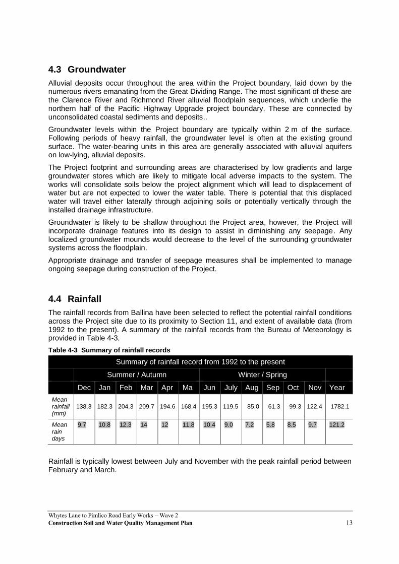
4.4 Rainfall
The rainfall records from Ballina have been selected to reflect the potential rainfall conditions across the Project site due to its proximity to Section 11, and extent of available data (from 1992 to the present). A summary of the rainfall records from the Bureau of Meteorology is provided in Table 4-3.
Table 4-3 Summary of rainfall records
Summary of rainfall record from 1992 to the present
Summer / Autumn Winter / Spring
Dec Jan Feb Mar Apr Ma Jun July Aug Sep Oct Nov Year
Mean rainfall (mm)
138.3 182.3 204.3 209.7 194.6 168.4 195.3 119.5 85.0 61.3 99.3 122.4 1782.1
Mean rain days
9.7 10.8 12.3 14 12 11.8 10.4 9.0 7.2 5.8 8.5 9.7 121.2
Rainfall is typically lowest between July and November with the peak rainfall period between February and March.
Whytes Lane to Pimlico Road Early Works – Wave 2
Construction Soil and Water Quality Management Plan 14
4.5 Rainfall erosivity factor
The rainfall erosivity factor is a measure of the ability of rainfall to cause erosion (referred as “R” in the Revised Universal Soil Loss Equitation RUSLE). The rainfall erosivity factor is used to determine the soil loss in tonnes per hectare over one year, and is used in calculations when sizing construction sediment basins.
The Project has a Rainfall Erosivity Factor of 5000. Ballina is the closest location with detailed R-factor data. In comparison Sydney has an R-factor of 4000. Generally, the months in which the highest rainfall totals have been recorded (February and March) in the Project location (refer to Table 4-13) will be relative to the highest erosion hazard and potential for soil loss. Conversely, those months in which the lowest rainfall totals have been recorded July and November have a lower erosion hazard and potential for soil loss.
4.6 Flooding
The Project is located in the Richmond River Catchment. The catchment is subject to frequent and extensive flooding, which can be caused by one or a combination of:
Rainfall in the upper catchment
Rainfall in the local catchment
Large ocean tides. The Project crosses the Richmond River, Emigrant Creek and Duck Creek floodplains and several smaller watercourses including Loch Canal which contains permanent water and is directly connected to Duck Creek. The watercourses crossed by the Project are further described in Table 8-3 of the EIS.
Flooding is generally concentrated on and around the coastal floodplains and inundation in these areas. This can result in damage to buildings and roads, loss or stranding of livestock, loss of crops and blocked access. Flooding also occurs in some upper catchment waterways where fast flows and rapid changes to creek levels can eventuate.
Hydrological and hydraulic models were used to simulate flows and flood behaviour for all mapped watercourses and associated floodplains crossed by the Project (refer to Section 8.2 of the EIS). Over 15 different models were used, with the model type depending upon the size and characteristics of the waterway being examined.
The level of the existing highway is below the 20 year ARI flood event level in many locations. This means that the highway can be inundated by floodwaters during a 20 year ARI flood event. Ancillary facilities associated with the Project must be situated above the 20 year ARI flood event level.
Details of flood investigation areas and flood events assessed (two year, five year, 20 year, 50 year 100 year and 200 year ARI events) are included in Table 8-2 of the EIS, and more broadly in Chapter 8 of the EIS. The impacts associated with flood events in between these events or smaller than the two or five year ARI flood events can be generally estimated by interpolation or extrapolation of these results. The exceptions to the relationship described above are on the Clarence and Richmond river floodplains. Here, the floodplain flows are quite complex with considerable interaction between floodplain flow paths over a range of flood events.
Ballina township and the surrounding area, including areas within the Project boundary, are particularly flood-prone. Many properties along Duck Creek, Emigrant Creek and the lower Richmond River have experienced flooding (refer to Table 8-9 of the EIS).

Whytes Lane to Pimlico Road Early Works – Wave 2
Construction Soil and Water Quality Management Plan 15
The Project site currently experiences problems associated with inundation during intense rain events, causing flooding of properties and roads. Considerable depths of soft soils (up to 20m in some areas) occur in sections of the Project. The soft soils have a low shear strength and permeability, and high compressibility. Ground treatments comprising pre-load, surcharge with and without wick drains have been adopted to control long term settlement.
The proposed works will take up flood plain storage and may affect flow paths leading to increases in flood levels on the western side of the highway. Other works for example, ancillary facilities, construction of haulage roads and installation of concrete barriers may also have an impact on the modelled flooding characteristics.
To ensure the Project works do not worsen flooding (as defined in the EIS and SPIR) the works will be stage to:
Not increase the flood levels by greater than 50mm
Not increase durations by more than 5% in any flood event; and
For velocities the flowing applies:
o Where velocities are currently below 1m/s they must remain below 1m/s
o Where velocities are above 1m/s they must not increase by more than 20%
The design of embankments constructed as part of the Project works taken into account flood modelling and will include stability measures such as the use of high strength geosynthetics, reinforcement, drainage layers, and stability berms. The flow of water through local waterways and agricultural drains crossed by the embankments would be maintained through temporary culverts. The potential adverse flooding impacts associated with the Project site are further outlined in Chapter 5 of this Plan.
Management of the potential for flooding impacts on construction activities is further detailed in the Flood Warning and Evacuation Management Plan.
Whytes Lane to Pimlico Road Early Works – Wave 2Construction Soil and Water Quality Management Plan 16
5 Environmental aspects and impacts
5.1 Construction activities
Key aspects of the Project that could result in adverse impacts to soils and water include:
Vegetation clearing, grubbing and topsoil stripping.
Mulching of vegetation.
Bulk earthworks.
Transportation associated with the bulk material import and haulage required by the Project
Site access including temporary waterway crossings.
Culvert and drainage works.
Material stockpiles including the treatment of acid Sulfate soil..
Water use / extraction.
Compounds operation including fuel and chemical storage, refuelling and chemical handling.
Weed treatment including herbicide spraying.
Refer also to the Aspects and Impacts Register included in Appendix A2 of the CEMP.
5.2 Potential Impacts
The potential for adverse impacts on soil and water will depend on the nature, extent and magnitude of construction activities and their interaction with the natural environment. Potential adverse impacts attributable to construction include:
Exposure of soils during vegetation clearing and earthworks, creating the potential for off-site transport of eroded sediments and pollutants.
Sensitive area damage from inappropriate stockpiling activities.
Production of tannins from mulch during clearing.
Increase in flood levels due to embankments near Duck Creek. The raised road from Whytes Lane to Duck Creek is expected to cause some increase in peak flood levels associated with flows from the catchments to the west of the highway building up behind the project embankment. For 20, 100 and 200 year ARI flood events, these impacts are less than 30 mm. This is consistent with the approved design as specified with G1 cl 26.1.
Disturbance of acid sulfate soils, creating the potential for oxidation of these soils and subsequent generation of acidic run-off.
Alteration of surface and subsurface flows that could cause disturbances to hydrology and hydraulics.
A reduction in groundwater levels and flows, and off-site discharge of water containing sediment from dewatering activities.
Interception and interference with an aquifer that could obstruct groundwater flow and limit groundwater availability.
Contamination of soils, and surface and groundwater from accidental spills or oil leaks. This might include grease or fuel from machinery and vehicles, construction sites or

Whytes Lane to Pimlico Road Early Works – Wave 2
Construction Soil and Water Quality Management Plan 17
compounds, or spills of other chemicals that may be used during the course of construction.
Disturbance of unidentified contaminated land e.g. former cattle tick dip sites, or other pesticide/chemical concentrations in soil from historical land use practices, and subsequent generation of contaminated runoff.
Some impacts on soil and water attributable to the Project are anticipated. Relevant aspects and the potential for related impacts have been considered in a risk assessment at Section 3.4 and Appendix A2 of the CEMP. Chapter 6 provides a suite of mitigation measures that will be implemented to avoid or minimise those impacts.
Whytes Lane to Pimlico Road Early Works – Wave 2Construction Soil and Water Quality Management Plan 18
6 Environmental control measures During construction activities, environmental management measures are to be undertaken to reduce the risk of adverse environmental issues or incidents due to impacts on existing soil and water quality. The following general construction activities are likely to have some impact on the management of soil and water along the road corridor:
Demolition and excavation works;
Site clearing of vegetation;
Plant maintenance;
Importing, handling, stockpiling and transporting material resources;
Embankment filling; and
Interception (dewatering) of current surface and subsurface flows. A range of environmental requirements and control measures are identified in the various environmental documents, including the EIS, supplementary assessments, Conditions of Approval and RMS documents, and from recent experience on similar road projects. Specific measures and requirements to address impacts on soil and water are outlined in Table 6-1.

Whytes Lane to Pimlico Road Early Works – Wave 2Construction Soil and Water Quality Management Plan 19
Table 6-1 Soil and water management and mitigation measures
ID Measure / Requirement Resources needed
When to implement
Responsibility Reference
GENERAL
SW1 Training will be provided to all project personnel, including relevant sub-contractors on sound erosion and sediment control practices and the requirements from this plan through inductions, toolboxes and targeted training.
Training Program Pre-construction / Construction
Construction Manager / Environmental Site Representative
G38/G36, Good practice
SW2 A Project Soil Conservationist will be engaged during detailed design to develop an erosion and sedimentation management report to inform this Soil and Water Quality Management Plan and will be regularly consulted throughout construction to provide advice on erosion and sediment control design, installation and maintenance.
Erosion and sedimentation management report
Pre-construction / Construction
Environmental Site Representative
G38, Good practice, Submissions / PIR (SSW5)
SW3 An environmental protection scheduled activity licence will be obtained for the Project. All relevant conditions relating to soil and water management will be implemented as required by the licence.
EPL Construction / Post construction
Construction Manager POEO Act 1997
PROCEDURES AND PLANS
SW4 Erosion and Sediment Control Plans (ESCPs) will be prepared and implemented in advance of construction, including earthworks and stockpiling. ESCPs and will be updated progressively during the works and as determined by the Project Soil Conservationist.
ESCP’s Pre-construction / Construction
Environmental Site Representative / Foreman
Managing Urban Stormwater: Soils and Construction Volume 1 and Volume 2D, EIS (SSW4)
SW5 The following EWMS will be prepared and implemented to manage soil and water impacts. EWMS for activities identified as having high environmental risk will undergo a period of consultation with EPA, the DPI Water, and DPI Fisheries Conservation and Aquaculture. Those marked with an asterisk below are those likely to be subject to consultation:
Activities that impact on environmentally sensitive areas*
EWMS’s Construction Superintendent / Environmental Site Representative
G36 and G40

Whytes Lane to Pimlico Road Early Works – Wave 2
Construction Soil and Water Quality Management Plan 20
ID Measure / Requirement Resources needed
When to implement
Responsibility Reference
Working platforms in or adjacent to waterways*
Concreting activities
Management of Acid Sulfate Materials*
Dewatering*
Managing tannin leachate*
Vegetation clearing and grubbing*
Topsoil stripping*
SW6 All ASS or PASS disturbed during the construction process will be managed in accordance with the Construction Acid Sulfate Soil Management Plan (incorporating an Acid Sulfate Soils contingency plan as required under CoA D26(c)v) attached at Appendix B11 of the CEMP.
App B11, Training Program
Pre-construction / Construction
Superintendent / Environmental Site Representative
Submissions / PIR (SSW25)
CoA D26(c) v
SW7 The requirements of the spoil and fill management procedure attached at Appendix B of this Management Plan will be implemented throughout construction. The plan includes, among other detail, the types of material expected to be encountered during construction, and how excavated material will be handled, transported, stockpiled, reused and disposed.
Training Program Construction Superintendent / Foreman CoA D25(d)ix
SW8 Dewatering will be undertaken and managed in accordance with the Pacific Highway Projects Dewatering Guidelines attached at Appendix G of this Management Plan. A specific EWMS for dewatering will be prepared and will consider and/or incorporate the following detail:
Areas of the site that will require dewatering.
Dewatering methods that will minimise potential environmental impacts.
Opportunities for reuse.
The limitations for any proposed reuse methods.
Discharge locations and adequate energy
Training Program Construction Superintendent / Environmental Site Representative
G38 (Section3.5)

Whytes Lane to Pimlico Road Early Works – Wave 2
Construction Soil and Water Quality Management Plan 21
ID Measure / Requirement Resources needed
When to implement
Responsibility Reference
dissipation.
Water quality criteria for discharge and/or reuse.
Treatment techniques required to meet the water quality criteria.
Water sampling and testing requirements.
Where dewatering activities have the potential to impact terrestrial or aquatic flora and fauna, a project/aquatic ecologist must review the process and provide input prior to dewatering taking place.
SOIL EROSION AND SEDIMENTATION CONTROL
SW9 Appropriate erosion and sediment controls, following the guidelines of the ‘Blue Books’ (Landcom, 2004 and DECC, 2008), will be established before the start of construction and maintained in effective working order for the duration of the construction period until site stabilisation. Specific controls will include:
Sediment fences and filters to intercept and filter small volumes of non-concentrated construction runoff
Rock check dams across swales and diversion channels to reduce the velocity of flow, thereby reducing erosion of the channel bed and trapping sediment
Level spreaders to convert erosive, concentrated flow into sheet flow
Diversion drains that collect construction runoff and direct it away from unstable and/or exposed soil to treatment facilities
Diversion drains to collect clean runoff from upstream of the construction area and divert it around or through the site without it mixing with construction runoff
Lining of channels and other concentrated flow paths
Sedimentation basins to capture sediment and
Training Program;
Blue Book
Construction Superintendent / Foreman / Environmental Site Representative
CoA B34
Submissions / PIR (SSW26) / EPL/ POEO Act
Whytes Lane to Pimlico Road Early Works – Wave 2
Construction Soil and Water Quality Management Plan 22
ID Measure / Requirement Resources needed
When to implement
Responsibility Reference
associated pollutants in construction runoff (see further details below)
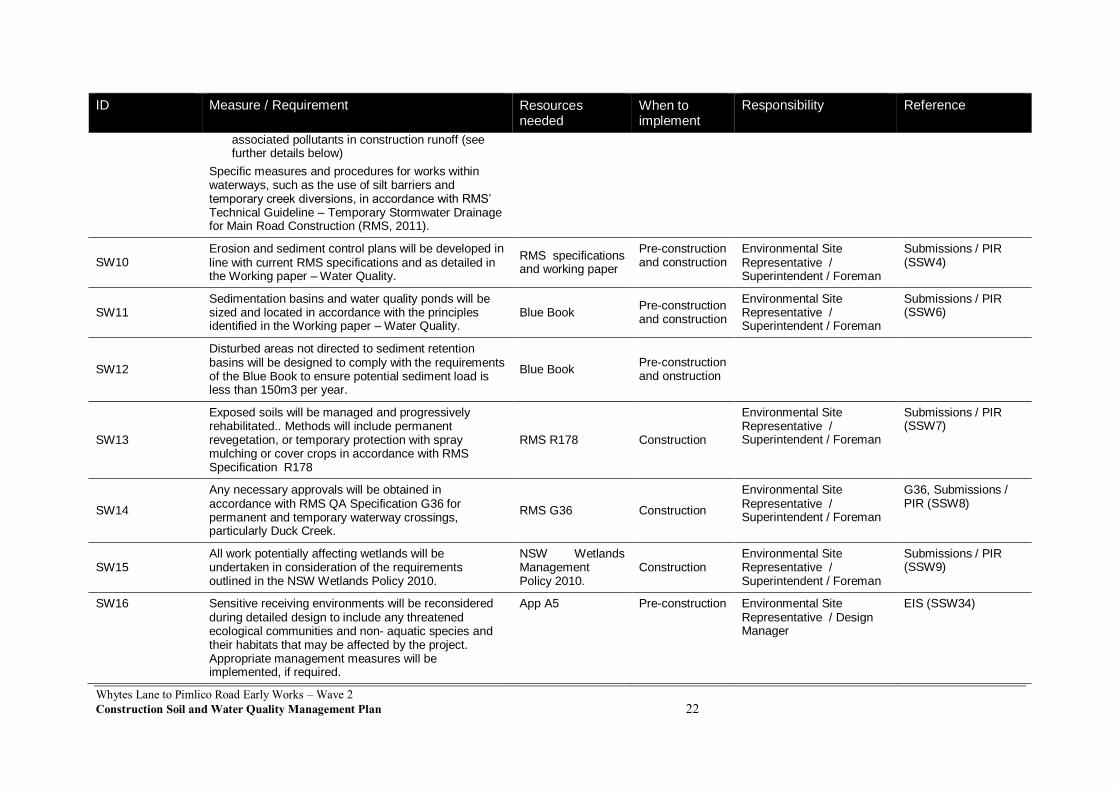
Specific measures and procedures for works within waterways, such as the use of silt barriers and temporary creek diversions, in accordance with RMS’ Technical Guideline – Temporary Stormwater Drainage for Main Road Construction (RMS, 2011).
SW10 Erosion and sediment control plans will be developed in line with current RMS specifications and as detailed in the Working paper – Water Quality.
RMS specifications and working paper
Pre-construction and construction
Environmental Site Representative / Superintendent / Foreman
Submissions / PIR (SSW4)
SW11 Sedimentation basins and water quality ponds will be sized and located in accordance with the principles identified in the Working paper – Water Quality.
Blue Book Pre-construction and construction
Environmental Site Representative / Superintendent / Foreman
Submissions / PIR (SSW6)
SW12
Disturbed areas not directed to sediment retention basins will be designed to comply with the requirements of the Blue Book to ensure potential sediment load is less than 150m3 per year.
Blue Book Pre-construction and onstruction
SW13
Exposed soils will be managed and progressively rehabilitated.. Methods will include permanent revegetation, or temporary protection with spray mulching or cover crops in accordance with RMS Specification R178
RMS R178 Construction
Environmental Site Representative / Superintendent / Foreman
Submissions / PIR (SSW7)
SW14
Any necessary approvals will be obtained in accordance with RMS QA Specification G36 for permanent and temporary waterway crossings, particularly Duck Creek.
RMS G36 Construction
Environmental Site Representative / Superintendent / Foreman
G36, Submissions / PIR (SSW8)
SW15 All work potentially affecting wetlands will be undertaken in consideration of the requirements outlined in the NSW Wetlands Policy 2010.
NSW Wetlands Management Policy 2010.
Construction Environmental Site Representative / Superintendent / Foreman
Submissions / PIR (SSW9)
SW16 Sensitive receiving environments will be reconsidered during detailed design to include any threatened ecological communities and non- aquatic species and their habitats that may be affected by the project. Appropriate management measures will be implemented, if required.
App A5 Pre-construction Environmental Site Representative / Design Manager
EIS (SSW34)
Whytes Lane to Pimlico Road Early Works – Wave 2
Construction Soil and Water Quality Management Plan 23
ID Measure / Requirement Resources needed
When to implement
Responsibility Reference
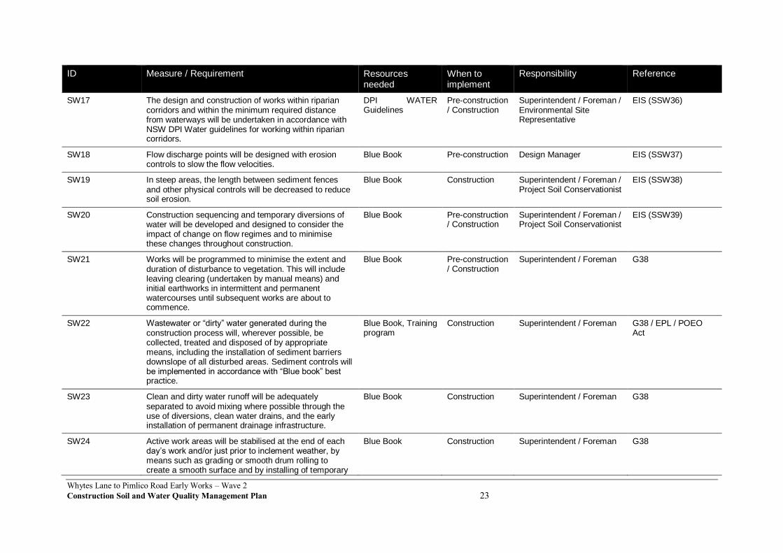
SW17 The design and construction of works within riparian corridors and within the minimum required distance from waterways will be undertaken in accordance with NSW DPI Water guidelines for working within riparian corridors.
DPI WATER Guidelines
Pre-construction / Construction
Superintendent / Foreman / Environmental Site Representative
EIS (SSW36)
SW18 Flow discharge points will be designed with erosion controls to slow the flow velocities.
Blue Book Pre-construction Design Manager EIS (SSW37)
SW19 In steep areas, the length between sediment fences and other physical controls will be decreased to reduce soil erosion.
Blue Book Construction Superintendent / Foreman / Project Soil Conservationist
EIS (SSW38)
SW20 Construction sequencing and temporary diversions of water will be developed and designed to consider the impact of change on flow regimes and to minimise these changes throughout construction.
Blue Book Pre-construction / Construction
Superintendent / Foreman / Project Soil Conservationist
EIS (SSW39)
SW21 Works will be programmed to minimise the extent and duration of disturbance to vegetation. This will include leaving clearing (undertaken by manual means) and initial earthworks in intermittent and permanent watercourses until subsequent works are about to commence.
Blue Book Pre-construction / Construction
Superintendent / Foreman G38
SW22 Wastewater or “dirty” water generated during the construction process will, wherever possible, be collected, treated and disposed of by appropriate means, including the installation of sediment barriers downslope of all disturbed areas. Sediment controls will be implemented in accordance with “Blue book” best practice.
Blue Book, Training program
Construction Superintendent / Foreman G38 / EPL / POEO Act
SW23 Clean and dirty water runoff will be adequately separated to avoid mixing where possible through the use of diversions, clean water drains, and the early installation of permanent drainage infrastructure.
Blue Book Construction Superintendent / Foreman G38
SW24 Active work areas will be stabilised at the end of each day’s work and/or just prior to inclement weather, by means such as grading or smooth drum rolling to create a smooth surface and by installing of temporary
Blue Book Construction Superintendent / Foreman G38
Whytes Lane to Pimlico Road Early Works – Wave 2
Construction Soil and Water Quality Management Plan 24
ID Measure / Requirement Resources needed
When to implement
Responsibility Reference
“catch” drains to prevent / minimise transport of sediment.
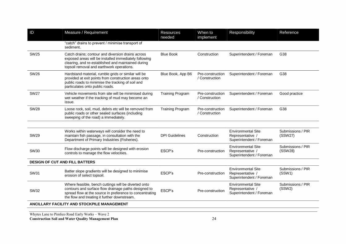
SW25 Catch drains; contour and diversion drains across exposed areas will be installed immediately following clearing, and re-established and maintained during topsoil removal and earthwork operations.
Blue Book Construction Superintendent / Foreman G38
SW26 Hardstand material, rumble grids or similar will be provided at exit points from construction areas onto public roads to minimise the tracking of soil and particulates onto public roads.
Blue Book, App B6 Pre-construction / Construction
Superintendent / Foreman G38
SW27 Vehicle movements from site will be minimised during wet weather if the tracking of mud may become an issue.
Training Program Pre-construction / Construction
Superintendent / Foreman Good practice
SW28 Loose rock, soil, mud, debris etc will be removed from public roads or other sealed surfaces (including sweeping of the road) a immediately.
Training Program Pre-construction / Construction
Superintendent / Foreman G38
SW29 Works within waterways will consider the need to maintain fish passage, in consultation with the Department of Primary Industries (Fisheries).
DPI Guidelines Construction Environmental Site Representative / Superintendent / Foreman
Submissions / PIR (SSW27)
SW30 Flow discharge points will be designed with erosion controls to manage the flow velocities.
ESCP’s Pre-construction Environmental Site Representative / Superintendent / Foreman
Submissions / PIR (SSW28)
DESIGN OF CUT AND FILL BATTERS
SW31 Batter slope gradients will be designed to minimise erosion of select topsoil.
ESCP’s Pre-construction Environmental Site Representative / Superintendent / Foreman
Submissions / PIR (SSW1)
SW32
Where feasible, bench cuttings will be diverted onto contours and surface flow drainage paths designed to spread flow at the source in preference to concentrating the flow and treating it further downstream.
ESCP’s Pre-construction
Environmental Site Representative / Superintendent / Foreman
Submissions / PIR (SSW2)
ANCILLARY FACILITY AND STOCKPILE MANAGEMENT

Whytes Lane to Pimlico Road Early Works – Wave 2
Construction Soil and Water Quality Management Plan 25
ID Measure / Requirement Resources needed
When to implement
Responsibility Reference
SW33 Stockpiles and ancillary facilities will be established to minimise erosion and in accordance with the criteria outlined in Appendix B8 of the CEMP and Appendix I of this plan.
App B8 CEMP and App I of this Plan
Pre-construction / Construction
Superintendent / Foreman / Environmental Site Representative
CoA D21, CoA D25(d)ix, G38, Submissions / PIR (SSW11 – SSW13)
SW34 Measures to be implemented to minimise impacts to surface and ground water quality include:
Providing bunded storage facilities for chemicals, fuel, oil lubricants etc.
Bunded areas for refuelling and washdown.
Locating storage areas away from areas of known near-surface groundwater supplies, at least 50m from aquatic habitat, away from flood prone areas or on slopes not greater than 1:10.
EPA Guidelines Construction Environmental Site Representative / Superintendent / Foreman
Submissions / PIR (SSW37)
SW35
At ancillary facilities, management of runoff and spills will include:
Restricting vehicle movements to designated pathways where feasible.
Paving areas that will be exposed for extended periods, such as car parks and main access roads, where reasonable and feasible.
Diverting off-site runoff around sites where required.
Locating chemical or other hazardous material storage areas away from areas of known near-surface groundwater supplies, at least 50m from aquatic habitat, away from flood prone areas or on slopes not greater than 1:10.
ESCP, App B8
Construction
Environmental Site Representative / Superintendent / Foreman
Submissions / PIR (SSW38)
SW36 Soil and water management at borrow source sites will be in line with Volume 2E of the Blue Book which covers water management of mines and quarries.
Blue Book Vol 2E Construction Environmental Site Representative / Superintendent / Foreman
Submissions / PIR (SSW39)
SW37 Topsoil, earthworks and other excess spoil material will be stockpiled and managed in accordance with the Stockpile Management Protocol (refer to Appendix I)
App I of this Plan Construction Environmental Site Representative / Superintendent / Foreman
Submissions / PIR (SSW10)

Whytes Lane to Pimlico Road Early Works – Wave 2
Construction Soil and Water Quality Management Plan 26
ID Measure / Requirement Resources needed
When to implement
Responsibility Reference
and the “Management of Surplus Material” in Section 3.9 of the Submissions / Preferred Infrastructure Report.
SW38
Stockpiles will be located such that waterways and drainage lines are not directly or indirectly impacted.
Additionally, where reasonable and feasible, stockpiles will:
Not require removal of areas of native vegetation.
Be located outside of known areas of weed infestation.
ESCP Construction
Environmental Site Representative / Superintendent / Foreman
Submissions / PIR (SSW11)
SW39
Where practicable, stockpiles will be located away from areas subject to concentrated overland flow. Stockpiles located on a floodplain be finished and contoured so as to minimise loss of material in flood or rainfall events.
ESCP Construction
Environmental Site Representative / Superintendent / Foreman
Submissions / PIR (SSW12)
SW40 Topsoil will be stockpiled separately and inspected for weed seedlings at six monthly intervals and controlled with herbicide as required.
App B2 CFFMP Construction Environmental Site Representative / Superintendent / Foreman
Submissions / PIR (SSW13)
SW41
Weeds present on site will be controlled by:
Identifying weed infestations and segregating material cleared from these areas.
Restricting access into weed infested areas for plant and vehicles.
Decontaminating plant and vehicles prior to moving from weed infested areas.
Containing weed material during transport and disposing to a licenced waste facility.
Further measures are detailed in the Appendix B2 of the CEMP
App B2, Induction Construction
Environmental Site Representative / Superintendent / Foreman
G38 (Sect 2.1.2), Good Practice
SW42 All construction stockpiles will comply with the requirements of the Protection of the Environment Operations Act 1997 and NSW Waste Avoidance and
App B7 Construction Environmental Site Representative / Superintendent / Foreman
Submissions / PIR (SSW14)
Whytes Lane to Pimlico Road Early Works – Wave 2
Construction Soil and Water Quality Management Plan 27
ID Measure / Requirement Resources needed
When to implement
Responsibility Reference
Resource Recovery Strategy 2007 for any waste activities that involve the generation, storage and/or disposal of waste and also consider the NSW Resource Recovery Exemptions as applying the storage of stockpiled material.
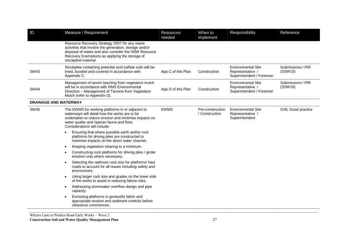
SW43 Stockpiles containing potential acid sulfate soils will be lined, bunded and covered in accordance with Appendix C.
App C of this Plan Construction Environmental Site Representative / Superintendent / Foreman
Submissions / PIR (SSW15)
SW44
Management of tannin leaching from vegetation mulch will be in accordance with RMS Environmental Direction – Management of Tannins from Vegetation Mulch (refer to Appendix D).
App D of this Plan Construction
Environmental Site Representative / Superintendent / Foreman
Submissions / PIR (SSW16)
DRAINAGE AND WATERWAY
SW45 The EWMS for working platforms in or adjacent to waterways will detail how the works are to be undertaken to reduce erosion and minimise impacts on water quality and riparian fauna and flora. Considerations will include:
Ensuring that where possible earth and/or rock platforms for driving piles are constructed to minimise impacts on the direct water channel.
Keeping vegetation clearing to a minimum.
Constructing rock platforms for driving piles / girder erection only where necessary.
Selecting the optimum rock size for platforms/ haul roads to account for all issues including safety and environment.
Using larger rock size and grades on the lower side of the works to assist in reducing failure risks.
Addressing stormwater overflow design and pipe capacity.
Enclosing platforms in geotextile fabric and appropriate erosion and sediment controls before clearance commences.
EWMS Pre-construction / Construction
Environmental Site Representative / Superintendent
G36, Good practice
Whytes Lane to Pimlico Road Early Works – Wave 2
Construction Soil and Water Quality Management Plan 28
ID Measure / Requirement Resources needed
When to implement
Responsibility Reference
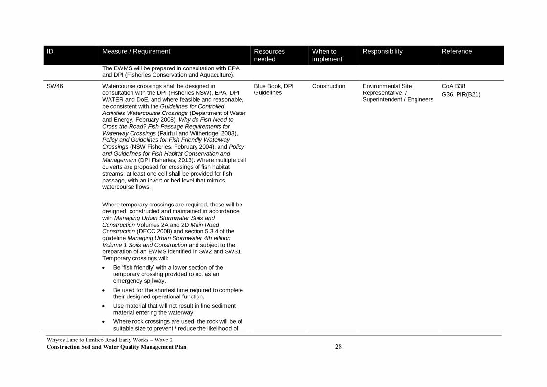
The EWMS will be prepared in consultation with EPA and DPI (Fisheries Conservation and Aquaculture).
SW46 Watercourse crossings shall be designed in consultation with the DPI (Fisheries NSW), EPA, DPI WATER and DoE, and where feasible and reasonable, be consistent with the Guidelines for Controlled Activities Watercourse Crossings (Department of Water and Energy, February 2008), Why do Fish Need to Cross the Road? Fish Passage Requirements for Waterway Crossings (Fairfull and Witheridge, 2003), Policy and Guidelines for Fish Friendly Waterway Crossings (NSW Fisheries, February 2004), and Policy and Guidelines for Fish Habitat Conservation and Management (DPI Fisheries, 2013). Where multiple cell culverts are proposed for crossings of fish habitat streams, at least one cell shall be provided for fish passage, with an invert or bed level that mimics watercourse flows.
Where temporary crossings are required, these will be designed, constructed and maintained in accordance with Managing Urban Stormwater Soils and Construction Volumes 2A and 2D Main Road Construction (DECC 2008) and section 5.3.4 of the guideline Managing Urban Stormwater 4th edition Volume 1 Soils and Construction and subject to the preparation of an EWMS identified in SW2 and SW31. Temporary crossings will:
Be ‘fish friendly’ with a lower section of the temporary crossing provided to act as an emergency spillway.
Be used for the shortest time required to complete their designed operational function.
Use material that will not result in fine sediment material entering the waterway.
Where rock crossings are used, the rock will be of suitable size to prevent / reduce the likelihood of
Blue Book, DPI Guidelines
Construction Environmental Site Representative / Superintendent / Engineers
CoA B38
G36, PIR(B21)

Whytes Lane to Pimlico Road Early Works – Wave 2
Construction Soil and Water Quality Management Plan 29
ID Measure / Requirement Resources needed
When to implement
Responsibility Reference
the material being washed away in a storm or flood event, with large sized rock on the lower side of crossings where water velocity increases.
Waterflow is to be maintained at all times in watercourses.
SW47 Scour protection will be installed at the base of permanent and temporary drainage outlets, and will be integrated where feasible into current banks to minimise impacts.
ESCP Construction Environmental Site Representative / Superintendent / Foreman
G36, G38
SW48 Drainage works will be stabilised against erosion by appropriate selection of channel dimensions, slope and lining, and the inclusion, if necessary, of drop structures and energy dissipaters.
ESCP Construction Environmental Site Representative / Superintendent / Foreman
Good practice
SW49 Culverts and permanent stream protection measures will be installed as early as possible in the construction program to facilitate transverse drainage during the early stages of construction.
ESCP Construction Environmental Site Representative / Superintendent / Foreman
Good practice
MANAGEMENT OF GROUNDWATER INTERSECTION
SW50
Where groundwater is released, recharge of the water table is the preferred option of managing groundwater. This will be facilitated by collecting groundwater in grassed swales for infiltration back to the groundwater source. Where possible, these swales will divert the groundwater around the construction area so that the groundwater does not further mix with construction runoff.
ESCP Construction
Environmental Site Representative / Superintendent / Foreman
Submissions / PIR (SSW42)
SW51
Dewatering of excavations will be undertaken in line with the Pacific Highway Projects Dewatering Practice Note (refer to Appendix G) and in accordance with any licence conditions.
APP G of this Plan
Construction Environmental Site Representative / Superintendent / Foreman
Submissions / PIR (SSW44)
GROUNDWATER
Whytes Lane to Pimlico Road Early Works – Wave 2
Construction Soil and Water Quality Management Plan 30
ID Measure / Requirement Resources needed
When to implement
Responsibility Reference
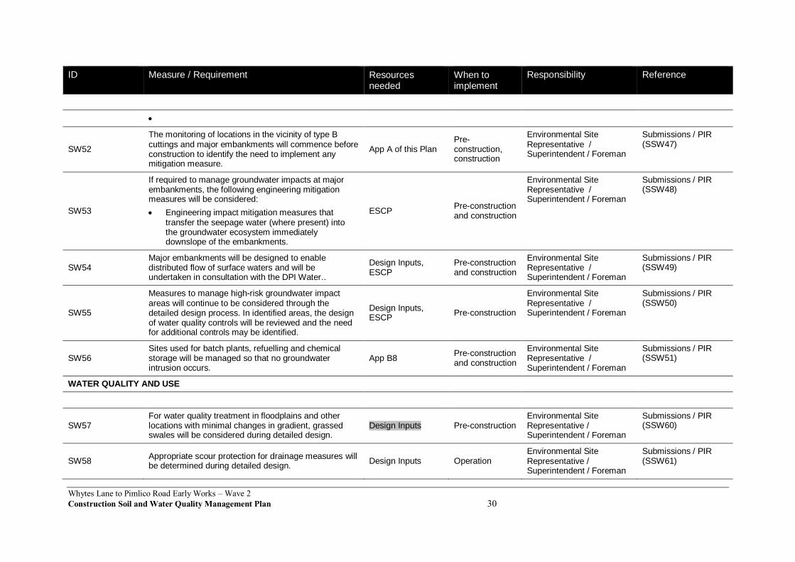
SW52
The monitoring of locations in the vicinity of type B cuttings and major embankments will commence before construction to identify the need to implement any mitigation measure.
App A of this Plan Pre-construction, construction
Environmental Site Representative / Superintendent / Foreman
Submissions / PIR (SSW47)
SW53
If required to manage groundwater impacts at major embankments, the following engineering mitigation measures will be considered:
Engineering impact mitigation measures that transfer the seepage water (where present) into the groundwater ecosystem immediately downslope of the embankments.
ESCP Pre-construction and construction
Environmental Site Representative / Superintendent / Foreman
Submissions / PIR (SSW48)
SW54 Major embankments will be designed to enable distributed flow of surface waters and will be undertaken in consultation with the DPI Water..
Design Inputs, ESCP
Pre-construction and construction
Environmental Site Representative / Superintendent / Foreman
Submissions / PIR (SSW49)
SW55
Measures to manage high-risk groundwater impact areas will continue to be considered through the detailed design process. In identified areas, the design of water quality controls will be reviewed and the need for additional controls may be identified.
Design Inputs, ESCP
Pre-construction
Environmental Site Representative / Superintendent / Foreman
Submissions / PIR (SSW50)
SW56 Sites used for batch plants, refuelling and chemical storage will be managed so that no groundwater intrusion occurs.
App B8 Pre-construction and construction
Environmental Site Representative / Superintendent / Foreman
Submissions / PIR (SSW51)
WATER QUALITY AND USE
SW57 For water quality treatment in floodplains and other locations with minimal changes in gradient, grassed swales will be considered during detailed design.
Design Inputs Pre-construction Environmental Site Representative / Superintendent / Foreman
Submissions / PIR (SSW60)
SW58 Appropriate scour protection for drainage measures will be determined during detailed design.
Design Inputs Operation Environmental Site Representative / Superintendent / Foreman
Submissions / PIR (SSW61)
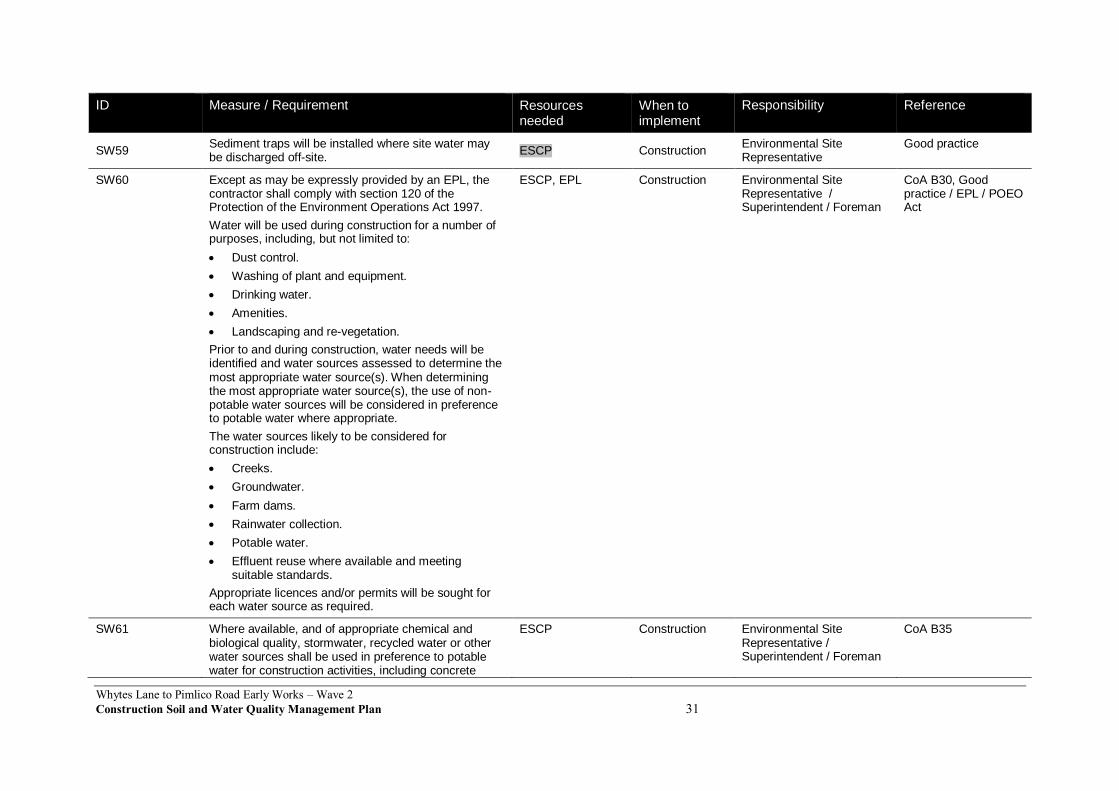
Whytes Lane to Pimlico Road Early Works – Wave 2
Construction Soil and Water Quality Management Plan 31
ID Measure / Requirement Resources needed
When to implement
Responsibility Reference
SW59 Sediment traps will be installed where site water may be discharged off-site.
ESCP Construction Environmental Site Representative
Good practice
SW60 Except as may be expressly provided by an EPL, the contractor shall comply with section 120 of the Protection of the Environment Operations Act 1997.
Water will be used during construction for a number of purposes, including, but not limited to:
Dust control.
Washing of plant and equipment.
Drinking water.
Amenities.
Landscaping and re-vegetation.
Prior to and during construction, water needs will be identified and water sources assessed to determine the most appropriate water source(s). When determining the most appropriate water source(s), the use of non-potable water sources will be considered in preference to potable water where appropriate.
The water sources likely to be considered for construction include:
Creeks.
Groundwater.
Farm dams.
Rainwater collection.
Potable water.
Effluent reuse where available and meeting suitable standards.
Appropriate licences and/or permits will be sought for each water source as required.
ESCP, EPL Construction Environmental Site Representative / Superintendent / Foreman
CoA B30, Good practice / EPL / POEO Act
SW61 Where available, and of appropriate chemical and biological quality, stormwater, recycled water or other water sources shall be used in preference to potable water for construction activities, including concrete
ESCP Construction Environmental Site Representative / Superintendent / Foreman
CoA B35
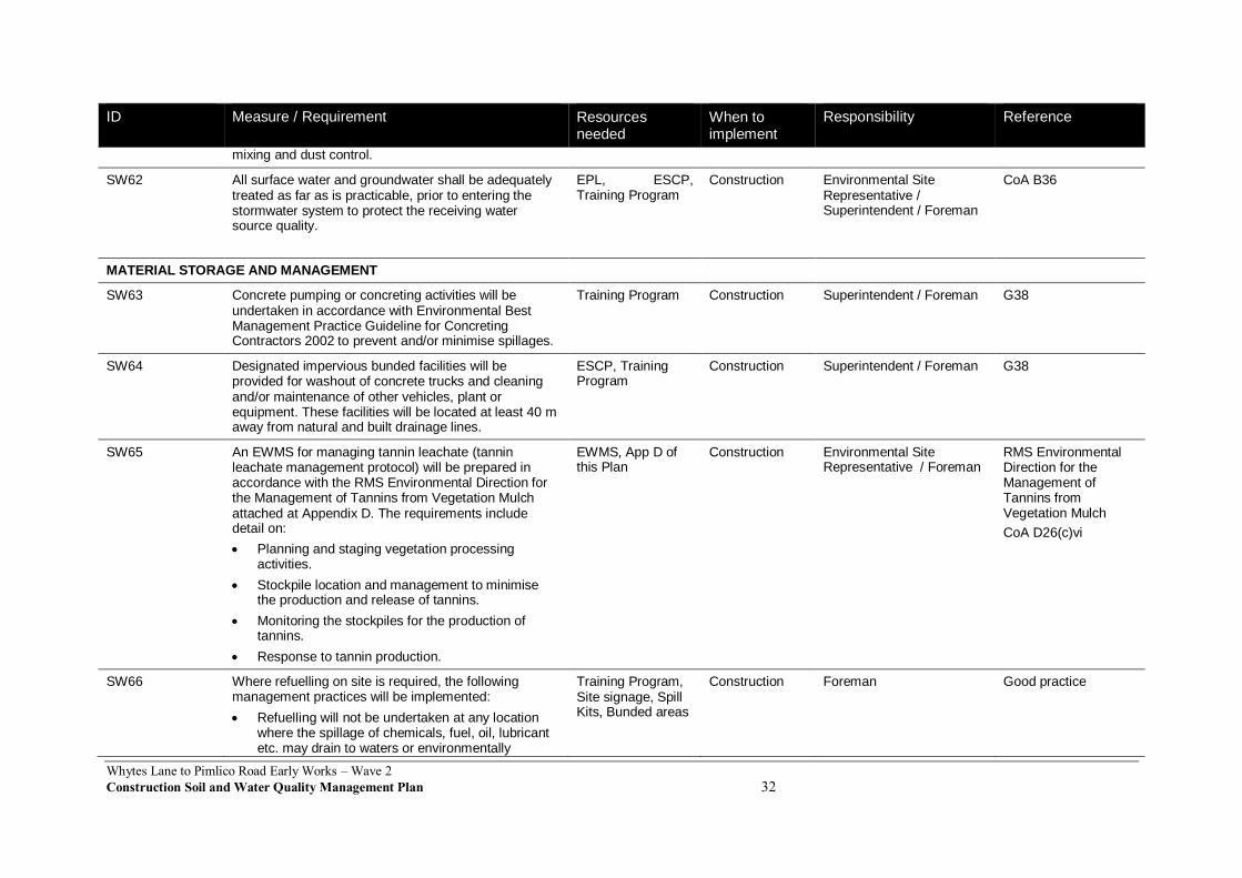
Whytes Lane to Pimlico Road Early Works – Wave 2
Construction Soil and Water Quality Management Plan 32
ID Measure / Requirement Resources needed
When to implement
Responsibility Reference
mixing and dust control.
SW62 All surface water and groundwater shall be adequately treated as far as is practicable, prior to entering the stormwater system to protect the receiving water source quality.
EPL, ESCP, Training Program
Construction Environmental Site Representative / Superintendent / Foreman
CoA B36
MATERIAL STORAGE AND MANAGEMENT
SW63 Concrete pumping or concreting activities will be undertaken in accordance with Environmental Best Management Practice Guideline for Concreting Contractors 2002 to prevent and/or minimise spillages.
Training Program Construction Superintendent / Foreman G38
SW64 Designated impervious bunded facilities will be provided for washout of concrete trucks and cleaning and/or maintenance of other vehicles, plant or equipment. These facilities will be located at least 40 m away from natural and built drainage lines.
ESCP, Training Program
Construction Superintendent / Foreman G38
SW65 An EWMS for managing tannin leachate (tannin leachate management protocol) will be prepared in accordance with the RMS Environmental Direction for the Management of Tannins from Vegetation Mulch attached at Appendix D. The requirements include detail on:
Planning and staging vegetation processing activities.
Stockpile location and management to minimise the production and release of tannins.
Monitoring the stockpiles for the production of tannins.
Response to tannin production.
EWMS, App D of this Plan
Construction Environmental Site Representative / Foreman
RMS Environmental Direction for the Management of Tannins from Vegetation Mulch
CoA D26(c)vi
SW66 Where refuelling on site is required, the following management practices will be implemented:
Refuelling will not be undertaken at any location where the spillage of chemicals, fuel, oil, lubricant etc. may drain to waters or environmentally
Training Program, Site signage, Spill Kits, Bunded areas
Construction Foreman Good practice
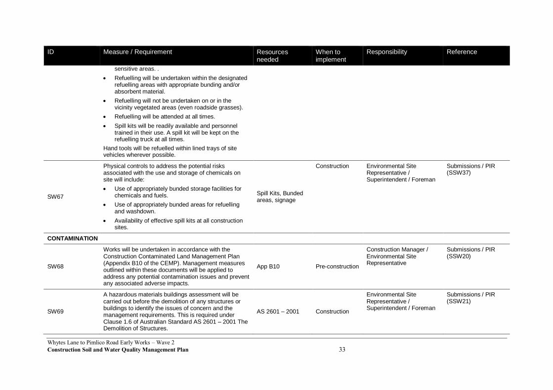
Whytes Lane to Pimlico Road Early Works – Wave 2
Construction Soil and Water Quality Management Plan 33
ID Measure / Requirement Resources needed
When to implement
Responsibility Reference
sensitive areas. .
Refuelling will be undertaken within the designated refuelling areas with appropriate bunding and/or absorbent material.
Refuelling will not be undertaken on or in the vicinity vegetated areas (even roadside grasses).
Refuelling will be attended at all times.
Spill kits will be readily available and personnel trained in their use. A spill kit will be kept on the refuelling truck at all times.
Hand tools will be refuelled within lined trays of site vehicles wherever possible.
SW67
Physical controls to address the potential risks associated with the use and storage of chemicals on site will include:
Use of appropriately bunded storage facilities for chemicals and fuels.
Use of appropriately bunded areas for refuelling and washdown.
Availability of effective spill kits at all construction sites.
Spill Kits, Bunded areas, signage
Construction Environmental Site Representative / Superintendent / Foreman
Submissions / PIR (SSW37)
CONTAMINATION
SW68
Works will be undertaken in accordance with the Construction Contaminated Land Management Plan (Appendix B10 of the CEMP). Management measures outlined within these documents will be applied to address any potential contamination issues and prevent any associated adverse impacts.
App B10 Pre-construction
Construction Manager / Environmental Site Representative
Submissions / PIR (SSW20)
SW69
A hazardous materials buildings assessment will be carried out before the demolition of any structures or buildings to identify the issues of concern and the management requirements. This is required under Clause 1.6 of Australian Standard AS 2601 – 2001 The Demolition of Structures.
AS 2601 – 2001 Construction
Environmental Site Representative / Superintendent / Foreman
Submissions / PIR (SSW21)

Whytes Lane to Pimlico Road Early Works – Wave 2
Construction Soil and Water Quality Management Plan 34
ID Measure / Requirement Resources needed
When to implement
Responsibility Reference
SW70
An emergency spill response plan (see Appendix J) will be developed and incorporated into the soils and water management plan. This plan will detail measures for the prevention, containment and clean-up of accidental spills of fuels and chemicals.
App J of this Plan Construction
Environmental Site Representative / Superintendent / Foreman
Submissions / PIR (SSW22)
SW71
The storage, handling and use of the chemicals and fuels will be in accordance with the Work Health and Safety Act 20110 and WorkCover’s Storage and Handling of Dangerous Goods Code of Practice (WorkCover, 2005).
Work Cover Code of Practice
Construction
Environmental Site Representative / Superintendent / Foreman
Submissions / PIR (SSW23)
SW72
The Contractor is to comply with the Unexpected Discovery of Contaminated Land Procedure, contained in Appendix A of the Construction Contaminated Land Management Plan (Appendix B10 of the CEMP), in the event that unidentified contaminated land is encountered during construction.
App B10 Construction
Environmental Site Representative / Superintendent / Foreman
Good practice
ACID SULFATE SOILS
SW73 All ASS or PASS disturbed during the construction process will be managed in accordance with the Construction Acid Sulfate Materials Management Plan (Appendix B11 to CEMP). . Specific controls to be implemented will include:
Capping of exposed surfaces with clean fill to prevent oxidation.
Placing excavated acid sulfate soils separately in a lined, bunded and covered area.
Neutralising acid sulfate soils for reuse (where appropriate) by using additives such as lime.
Disposing of acid sulfate soils where necessary in accordance with the relevant guidelines.).
The requirements will be incorporated into the EWMS for “Management of Acid Sulfate Materials” referred to in SW6.
App B11 Construction Foreman / Superintendent / Environmental Site Representative
EIS (SSW31, SSW32)
SW74 Strategies to remove / reduce risks associated with acid App B11 Pre-construction Environmental Site Submissions / PIR
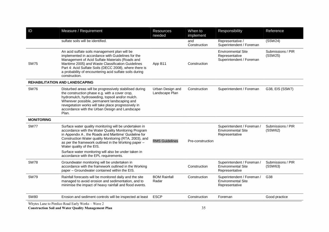
Whytes Lane to Pimlico Road Early Works – Wave 2
Construction Soil and Water Quality Management Plan 35
ID Measure / Requirement Resources needed
When to implement
Responsibility Reference
sulfate soils will be identified. and Construction
Representative / Superintendent / Foreman
(SSW24)
SW75
An acid sulfate soils management plan will be implemented in accordance with Guidelines for the Management of Acid Sulfate Materials (Roads and Maritime 2005) and Waste Classification Guidelines Part 4: Acid Sulfate Soils (DECC 2008), where there is a probability of encountering acid sulfate soils during construction.
App B11 Construction
Environmental Site Representative Superintendent / Foreman
Submissions / PIR (SSW25)
REHABILITATION AND LANDSCAPING
SW76 Disturbed areas will be progressively stabilised during the construction phase e.g. with a cover crop, hydromulch, hydroseeding, topsoil and/or mulch. Wherever possible, permanent landscaping and revegetation works will take place progressively in accordance with the Urban Design and Landscape Plan.
Urban Design and Landscape Plan
Construction Superintendent / Foreman G38, EIS (SSW7)
MONITORING
SW77 Surface water quality monitoring will be undertaken in accordance with the Water Quality Monitoring Program in Appendix A , the Roads and Maritime’ Guideline for Construction Water quality Monitoring (RTA, 2003), and as per the framework outlined in the Working paper – Water quality of the EIS.
Surface water monitoring will also be under taken in accordance with the EPL requirements.
RMS Guidelines Pre-construction
Superintendent / Foreman / Environmental Site Representative
Submissions / PIR (SSW62)
SW78 Groundwater monitoring will be undertaken in accordance with the framework outlined in the Working paper – Groundwater contained within the EIS.
Construction Superintendent / Foreman / Environmental Site Representative
Submissions / PIR (SSW63)
SW79 Rainfall forecasts will be monitored daily and the site managed to avoid erosion and sedimentation, and to minimise the impact of heavy rainfall and flood events.
BOM Rainfall Radar
Construction Superintendent / Foreman / Environmental Site Representative
G38
SW80 Erosion and sediment controls will be inspected at least ESCP Construction Foreman Good practice
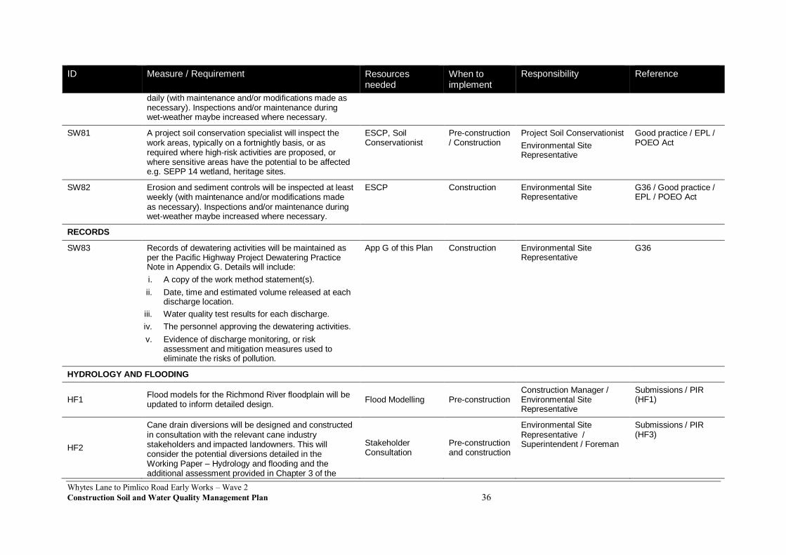
Whytes Lane to Pimlico Road Early Works – Wave 2
Construction Soil and Water Quality Management Plan 36
ID Measure / Requirement Resources needed
When to implement
Responsibility Reference
daily (with maintenance and/or modifications made as necessary). Inspections and/or maintenance during wet-weather maybe increased where necessary.
SW81 A project soil conservation specialist will inspect the work areas, typically on a fortnightly basis, or as required where high-risk activities are proposed, or where sensitive areas have the potential to be affected e.g. SEPP 14 wetland, heritage sites.
ESCP, Soil Conservationist
Pre-construction / Construction
Project Soil Conservationist
Environmental Site Representative
Good practice / EPL / POEO Act
SW82 Erosion and sediment controls will be inspected at least weekly (with maintenance and/or modifications made as necessary). Inspections and/or maintenance during wet-weather maybe increased where necessary.
ESCP Construction Environmental Site Representative
G36 / Good practice / EPL / POEO Act
RECORDS
SW83 Records of dewatering activities will be maintained as per the Pacific Highway Project Dewatering Practice Note in Appendix G. Details will include:
i. A copy of the work method statement(s).
ii. Date, time and estimated volume released at each discharge location.
iii. Water quality test results for each discharge.
iv. The personnel approving the dewatering activities.
v. Evidence of discharge monitoring, or risk assessment and mitigation measures used to eliminate the risks of pollution.
App G of this Plan Construction Environmental Site Representative
G36
HYDROLOGY AND FLOODING
HF1 Flood models for the Richmond River floodplain will be updated to inform detailed design.
Flood Modelling Pre-construction Construction Manager / Environmental Site Representative
Submissions / PIR (HF1)
HF2
Cane drain diversions will be designed and constructed in consultation with the relevant cane industry stakeholders and impacted landowners. This will consider the potential diversions detailed in the Working Paper – Hydrology and flooding and the additional assessment provided in Chapter 3 of the
Stakeholder Consultation
Pre-construction and construction
Environmental Site Representative / Superintendent / Foreman
Submissions / PIR (HF3)
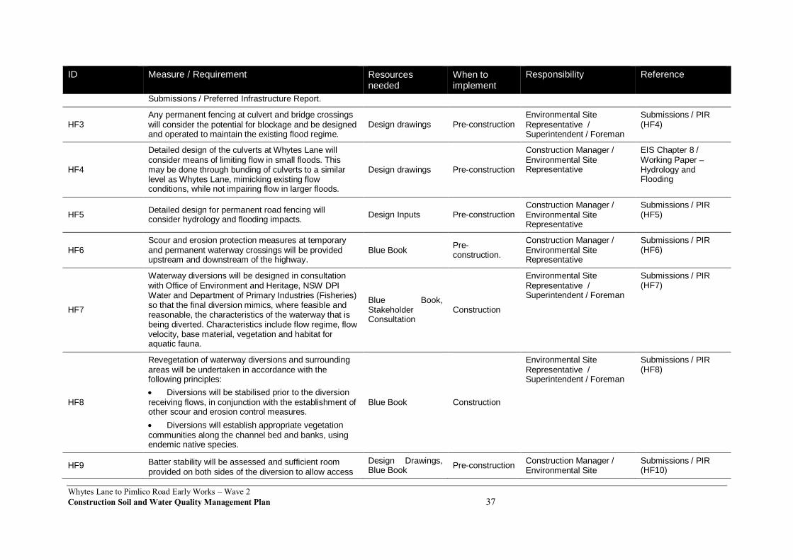
Whytes Lane to Pimlico Road Early Works – Wave 2
Construction Soil and Water Quality Management Plan 37
ID Measure / Requirement Resources needed
When to implement
Responsibility Reference
Submissions / Preferred Infrastructure Report.
HF3 Any permanent fencing at culvert and bridge crossings will consider the potential for blockage and be designed and operated to maintain the existing flood regime.
Design drawings Pre-construction Environmental Site Representative / Superintendent / Foreman
Submissions / PIR (HF4)
HF4
Detailed design of the culverts at Whytes Lane will consider means of limiting flow in small floods. This may be done through bunding of culverts to a similar level as Whytes Lane, mimicking existing flow conditions, while not impairing flow in larger floods.
Design drawings Pre-construction
Construction Manager / Environmental Site Representative
EIS Chapter 8 / Working Paper – Hydrology and Flooding
HF5 Detailed design for permanent road fencing will consider hydrology and flooding impacts.
Design Inputs Pre-construction Construction Manager / Environmental Site Representative
Submissions / PIR (HF5)
HF6 Scour and erosion protection measures at temporary and permanent waterway crossings will be provided upstream and downstream of the highway.
Blue Book Pre-construction.
Construction Manager / Environmental Site Representative
Submissions / PIR (HF6)
HF7
Waterway diversions will be designed in consultation with Office of Environment and Heritage, NSW DPI Water and Department of Primary Industries (Fisheries) so that the final diversion mimics, where feasible and reasonable, the characteristics of the waterway that is being diverted. Characteristics include flow regime, flow velocity, base material, vegetation and habitat for aquatic fauna.
Blue Book, Stakeholder Consultation
Construction
Environmental Site Representative / Superintendent / Foreman
Submissions / PIR (HF7)
HF8
Revegetation of waterway diversions and surrounding areas will be undertaken in accordance with the following principles:
Diversions will be stabilised prior to the diversion receiving flows, in conjunction with the establishment of other scour and erosion control measures.
Diversions will establish appropriate vegetation communities along the channel bed and banks, using endemic native species.
Blue Book Construction
Environmental Site Representative / Superintendent / Foreman
Submissions / PIR (HF8)
HF9 Batter stability will be assessed and sufficient room provided on both sides of the diversion to allow access
Design Drawings, Blue Book
Pre-construction Construction Manager / Environmental Site
Submissions / PIR (HF10)
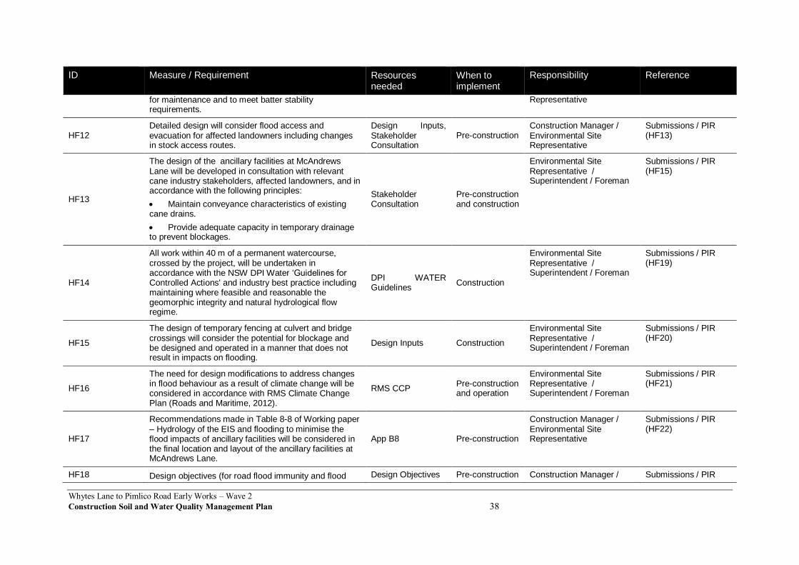
Whytes Lane to Pimlico Road Early Works – Wave 2
Construction Soil and Water Quality Management Plan 38
ID Measure / Requirement Resources needed
When to implement
Responsibility Reference
for maintenance and to meet batter stability requirements.
Representative
HF12 Detailed design will consider flood access and evacuation for affected landowners including changes in stock access routes.
Design Inputs, Stakeholder Consultation
Pre-construction Construction Manager / Environmental Site Representative
Submissions / PIR (HF13)
HF13
The design of the ancillary facilities at McAndrews Lane will be developed in consultation with relevant cane industry stakeholders, affected landowners, and in accordance with the following principles:
Maintain conveyance characteristics of existing cane drains.
Provide adequate capacity in temporary drainage to prevent blockages.
Stakeholder Consultation
Pre-construction and construction
Environmental Site Representative / Superintendent / Foreman
Submissions / PIR (HF15)
HF14
All work within 40 m of a permanent watercourse, crossed by the project, will be undertaken in accordance with the NSW DPI Water ‘Guidelines for Controlled Actions' and industry best practice including maintaining where feasible and reasonable the geomorphic integrity and natural hydrological flow regime.
DPI WATER Guidelines
Construction
Environmental Site Representative / Superintendent / Foreman
Submissions / PIR (HF19)
HF15
The design of temporary fencing at culvert and bridge crossings will consider the potential for blockage and be designed and operated in a manner that does not result in impacts on flooding.
Design Inputs Construction
Environmental Site Representative / Superintendent / Foreman
Submissions / PIR (HF20)
HF16
The need for design modifications to address changes in flood behaviour as a result of climate change will be considered in accordance with RMS Climate Change Plan (Roads and Maritime, 2012).
RMS CCP Pre-construction and operation
Environmental Site Representative / Superintendent / Foreman
Submissions / PIR (HF21)
HF17
Recommendations made in Table 8-8 of Working paper – Hydrology of the EIS and flooding to minimise the flood impacts of ancillary facilities will be considered in the final location and layout of the ancillary facilities at McAndrews Lane.
App B8 Pre-construction
Construction Manager / Environmental Site Representative
Submissions / PIR (HF22)
HF18 Design objectives (for road flood immunity and flood Design Objectives Pre-construction Construction Manager / Submissions / PIR
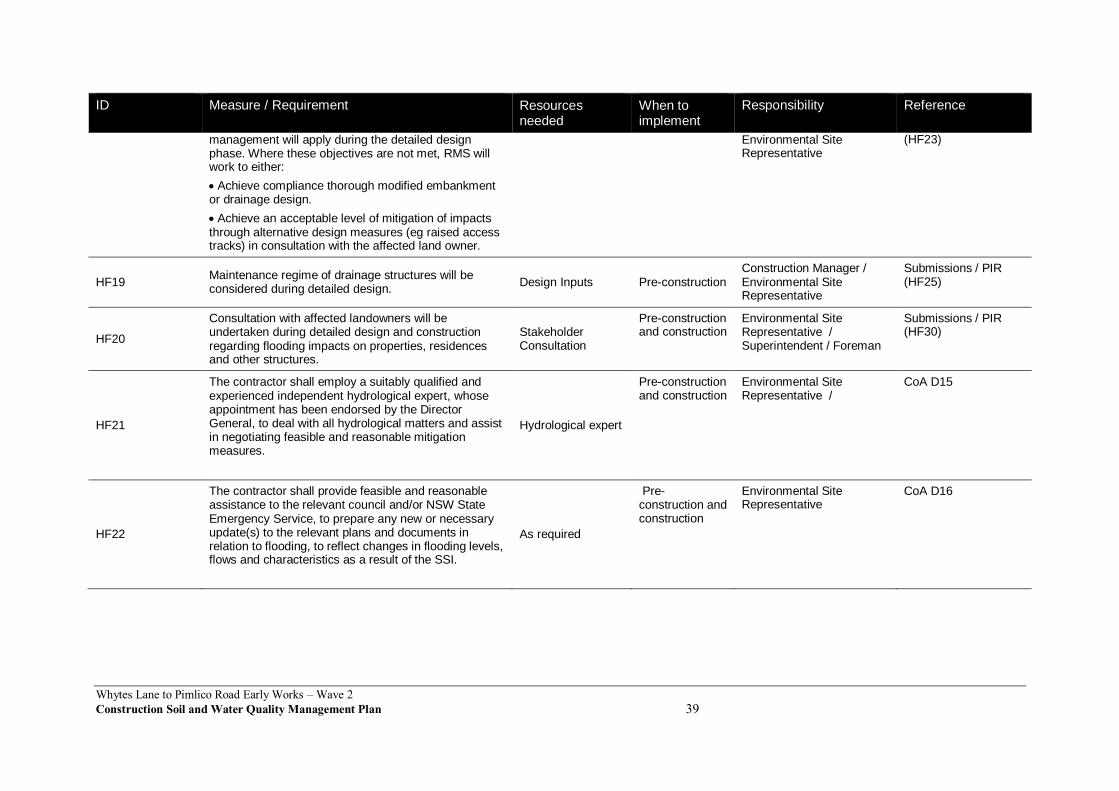
Whytes Lane to Pimlico Road Early Works – Wave 2
Construction Soil and Water Quality Management Plan 39
ID Measure / Requirement Resources needed
When to implement
Responsibility Reference
management will apply during the detailed design phase. Where these objectives are not met, RMS will work to either:
Achieve compliance thorough modified embankment or drainage design.
Achieve an acceptable level of mitigation of impacts through alternative design measures (eg raised access tracks) in consultation with the affected land owner.
Environmental Site Representative
(HF23)
HF19 Maintenance regime of drainage structures will be considered during detailed design.
Design Inputs Pre-construction Construction Manager / Environmental Site Representative
Submissions / PIR (HF25)
HF20
Consultation with affected landowners will be undertaken during detailed design and construction regarding flooding impacts on properties, residences and other structures.
Stakeholder Consultation
Pre-construction and construction
Environmental Site Representative / Superintendent / Foreman
Submissions / PIR (HF30)
HF21
The contractor shall employ a suitably qualified and experienced independent hydrological expert, whose appointment has been endorsed by the Director General, to deal with all hydrological matters and assist in negotiating feasible and reasonable mitigation measures.
Hydrological expert
Pre-construction and construction
Environmental Site Representative /
CoA D15
HF22
The contractor shall provide feasible and reasonable assistance to the relevant council and/or NSW State Emergency Service, to prepare any new or necessary update(s) to the relevant plans and documents in relation to flooding, to reflect changes in flooding levels, flows and characteristics as a result of the SSI.
As required
Pre-construction and construction
Environmental Site Representative
CoA D16

Whytes Lane to Pimlico Road Early Works – Wave 2Construction Soil and Water Quality Management Plan 40
7 Compliance management
7.1 Roles and responsibilities
The SEE Civil Project Team’s organisational structure and overall roles and responsibilities are outlined in Section 4.2 of the CEMP. Specific responsibilities for the implementation of environmental controls are detailed in Section 6 of this Plan.
7.2 Training
All employees, contractors and utility staff working on site will undergo site induction training relating to soil and water management issues. The induction training will address elements related to soil and water management including:
Existence and requirements of this CSWQMP.
Relevant legislation.
Roles and responsibilities for soil and water management.
The location of ASS or PASS.
Water quality management and protection measures.
Procedure to be implemented in the event of an unexpected discovery of contaminated land.
All new earthworks and sediment control personnel will be provided training in the ‘Bluebook Volume 2D’ and how it applies to the Project. The training will be equivalent to the course given by the NSW Soil Conservation Service. The Project appointed Soil Conservationist will assist in Project training involving erosion and sediment control issues.
Targeted training in the form of toolbox talks or specific training will also be provided to personnel with a key role in soil and water management. Examples of training topics include:
ERSED control installation methodology.
Working near or in drainage lines and creeks.
Emergency response measures in high rainfall events / Pollution Incident Response Management Plan (PIRMP).
Preparedness for high rainfall events.
Lessons learnt from incidents and other event e.g. high rainfall/flooding.
Mulch and tannin management.
Spill response.
Stockpile location criteria.
Identification of potentially contaminated spoil and fill material.
Further details regarding staff induction and training are outlined in Section 5 of the CEMP.
7.3 Monitoring and inspection
Regular monitoring and inspections will be undertaken in the lead up to, during and following construction. Monitoring and inspections will include, but not be limited to:
Up and downstream of the project alignment water quality monitoring at nominated locations.

Whytes Lane to Pimlico Road Early Works – Wave 2
Construction Soil and Water Quality Management Plan 41
Groundwater monitoring where impacts are anticipated.
Weekly and post rainfall inspections to evaluate the effectiveness of erosion and sediment controls measures in accordance with Section 8.1.1 of the CEMP.
All monitoring will be carried out in accordance with AS 5667.1 1987.
The type, timing, frequency, assessment criteria and associated reporting requirements are detailed in the Water Quality Monitoring Program (required as per CoA D12) attached at Appendix A. An inspection and maintenance register will be maintained for erosion and sediment capture measures. The register will include dates of discharge, water treatment performed, discharge water quality, sediment volumes removed from each device, sediment disposal methods and daily rainfall.
Additional requirements and responsibilities in relation to inspections are documented in Section 8.2 of the CEMP.
7.4 Licenses and permits
An Environment Protection License (EPL) will be obtained for the scheduled activity “road construction”. The EPL typically prescribes water quality parameters to be measured and associated discharge criteria. They also detail the monitoring and analytical requirements by reference to authority publications e.g. Approved Methods for Sampling and Analysis of Water Pollutants in NSW, 2004. The water quality discharge criteria for the Project are listed in Table 7-1
Table 7-1 Discharge water quality criteria
Parameter Criteria Sampling method Analytical method
pH* 6.5 –8.5 Probe or Grab Sample
Field analysis and confirmed as required with laboratory assessment
Turbidity TBA following correlation with TSS results
Grab Sample Field analysis and confirmed as required with laboratory assessment, regularly updating correlations and having a factor of conservatism.
Total Suspended Solids*
50 mg/L Grab Sample Laboratory analysis
Oil and Grease* No visible Grab Sample Field analysis and confirmed as required with laboratory assessment
Any other relevant licenses or permits will be obtained in the lead up to and during construction as required. Refer to CEMP – Section 3.3 Approvals, Permits & Licences.
7.5 Weather monitoring
Rainfall at the premises will be measured and recorded in millimetres per 24-hour period at the same time each day from the time that the site office associated with the activities is established. Automatic rainfall intensity/weather devices will be installed on the project, likely to be at the major compounds. The data collected from the automatic weather stations shall;
Provide a more detailed early understanding of potential rainfall and other adverse weather impacts
Provide a proactive and early inspection and maintenance regime response to erosion and sedimentation and the effects of other adverse climatic conditions before pollution occurs
Trigger weather alarms and messages to relevant site personnel to take action where appropriate

Whytes Lane to Pimlico Road Early Works – Wave 2
Construction Soil and Water Quality Management Plan 42
Assess and validate the performance of installed erosion and sediment control measures against the design performance criteria, and
Provide compliance data for statutory monitoring on-site. The stations shall record rainfall, temperature, relative humidity, wind speed, wind direction and bathometric pressure. The rain gauge within each mobile automatic weather station shall be of the tipping bucket type. The stations shall have a battery or voltage meter and shall target 98% reliability. Manual rain gauges will also be used across the project to assist with assessment of rainfall data accuracy. The weather stations shall conform to relevant standards for the location of such devices and shall be fully protected and secured. Data from the automatic weather stations shall be accessible via SMS alarms or queries to a mobile phone and downloadable to a desktop console logger or laptop computer. SMS queries and alarms shall be sent to RMS Representatives as necessary. All data shall be accessible at all times by the RMS representative(s). The mobile automatic weather stations shall download data to the internet and allow live views of weather data by authorised users, which shall include RMS Representative(s), the Project Verifier and the Environmental Representative. The mobile automatic weather stations shall also be compatible with and communicate live data to RMS’s online weather station page. In accordance with normal standard construction practices weather forecasts and monitoring of the Bureau of Meteorology rainfall radar shall be used to guide work activities undertaken on-site. Forecasts and current rainfall radar information shall be checked at the start of each day and prior to undertaking new work activities that may be affected by rainfall or adverse weather. Where weather conditions pose an environmental risk, site environmental controls shall be inspected and secured to reduce erosion and sediment control impacts. Contingency planning to prevent spills shall also involve monitoring for predicted flood events and the removal of fuels and chemicals from flood prone areas.
7.6 Auditing
Audits (both internal and external) will be undertaken to assess the effectiveness of environmental controls, compliance with this plan, CoA and other relevant approvals, licenses and guidelines.
Audit requirements are detailed in Section 8.3 of the CEMP.
7.7 Reporting
Reporting requirements and responsibilities are documented in the Water Quality Monitoring Program, and Chapter 7 and Section 8.3 of the CEMP.

Whytes Lane to Pimlico Road Early Works – Wave 2Construction Soil and Water Quality Management Plan 43
8 Review and improvement
8.1 Continuous improvement
Continuous improvement of this Plan will be achieved by the ongoing evaluation of environmental management performance against environmental policies, objectives and targets for the purpose of identifying opportunities for improvement.
The continuous improvement process will be designed to:
Identify areas of opportunity for improvement of environmental management and performance.
Determine the cause or causes of non-conformances and deficiencies.
Develop and implement a plan of corrective and preventative action to address any non-conformances and deficiencies.
Verify the effectiveness of the corrective and preventative actions.
Document any changes in procedures resulting from process improvement.
Make comparisons with objectives and targets.
8.2 CSWQMP update and amendment
The processes described in Section 8 and Section 9 of the CEMP may result in the need to update or revise this Plan. This will occur as needed.
Only the Environmental Site Representative , or delegate, has the authority to change any of the environmental management documentation.
A copy of the updated plan and changes will be distributed to all relevant stakeholders in accordance with the approved document control procedure – refer to Section 10.2 of the CEMP.
Appendix A Water Quality Monitoring Program
Refer to document:
Pacific Highway Upgrade Woolgoolga to Ballina Sections 3 to 11 Water Quality Monitoring Program (GeoLINK, 2015)

Appendix B Spoil and Fill Management Procedure
Appendix C Acid Sulfate Soil Management Procedure
Refer to document:
Construction Acid Sulfate Materials Management Plan (Appendix B11 to CEMP)

Appendix D Management of Tannins from Vegetation Mulch

ENVIRONMENTAL DIRECTION
Management of Tannins from Vegetation Mulch
JANUARY 2012

ABOUT THIS RELEASE
Environmental Direction number
25
Environmental Direction title
Management of Tannins from Vegetation Mulch
Author
Environment Branch (Environmental Policy)
Issue
Date
Revision description
1
December 2011
Final draft
2
January 2012
Final
COPYRIGHT
© NSW Roads and Maritime Services, 2011
All intellectual property and copyright reserved.
Apart from any fair dealing for the purpose of private study, research, criticism or review, as permitted under the Copyright Act, 1968, no part of this report may be reproduced, transmitted,
stored in a retrieval system or adapted in any form or by any means (electronic, mechanical, photocopying, recording or otherwise) without written permission.
i
ENVIRONMENTAL DIRECTION: Management of Tannins from Vegetation Mulch
Environmental Direction No. 25 January 2012 Printed copies of this document are uncontrolled
Page 1
CONTENTS
1 PURPOSE .............................................................................................................................. 2
2 MANAGEMENT MEASURES ................................................................................................. 2
2.1 General mulch management measures................................................................................. 2
2.1.1 Planning and works staging ..................................................................................... 2
2.1.2 Stockpile location and management ......................................................................... 2
2.1.3 Management measures for the use of mulch on site ................................................ 3
2.1.4 Monitoring and response .......................................................................................... 3
2.2 Mulch management methods for high risk sites. ............................................................... 3
2.2.1 High risk sites .......................................................................................................... 3
2.2.2 Stockpile management measures for high risk sites ................................................. 3
2.3 Site management procedures ............................................................................................... 3
3 BACKGROUND ...................................................................................................................... 4
3.1 Tannin generation from vegetation mulch ........................................................................ 4
3.2 Tannin impacts on water quality ....................................................................................... 4
3.3 Use of mulch on construction sites ................................................................................... 4
4 ADDITIONAL RESOURCES ................................................................................................... 5
5 APPENDICES ......................................................................................................................... 6
Appendix 1: Plates showing tannin generation & water quality impacts ....................................... 7
Appendix 2: Plates showing the use of mulch for erosion & sedimentation controls .................. 10
Appendix 3: Minimum requirements for community mulch giveaways ....................................... 14
Appendix 4: Community mulch giveaway information sheet ...................................................... 15
Appendix 5: Records template for community mulch giveaway ................................................. 17

ENVIRONMENTAL DIRECTION: Management of Tannins from Vegetation Mulch
Environmental Direction No. 25 January 2012 Printed copies of this document are uncontrolled
Page 2
1 PURPOSE
The purpose of this environmental direction is to set RMS’s minimum management measures to minimise the generation and discharge of tannins from vegetation mulch on Roads and Maritime Services (RMS) construction projects. Additional background information on tannins and the use of mulch on construction sites is included in section 3 of this direction.
2 MANAGEMENT MEASURES
The primary focus must be to minimise tannin generation on construction sites.
2.1 General mulch management measures
These general mulch management measures are to be followed for all RMS construction projects.
2.1.1 Planning and works staging
The first step in planning and works staging is to identify the amount of mulch to be generated. With this information, a strategy can be prepared to manage mulch on site. Staging of chipping, tub grinding and/or mulching activities should be planned to reduce the volume of mulch to be managed at any one time. The volume of excess mulch can then be assessed and plans made to dispose of this off site.
Other general considerations at the planning and works staging phase are as follows:
• Mulch stockpile sites should be established with appropriate controls in place before the main site clearing activities commence. Limited clearing may be required earlier for establishment of stockpile areas and access.
• Stage the mulching of cleared vegetation to ensure that mulch can be progressively moved to elevated, or otherwise suitable, stockpile locations. It is preferred that mulch should be transferred to a stockpile or reused on the day of mulching.
• Plan to efficiently reuse mulch in progressive works to reduce the time that mulch is concentrated in stockpile locations.
• Excess mulch can be managed by community giveaway. This takes considerable time and mulch needs to be suitably located and managed as this occurs. The conditions for community giveaway of mulch are included as Appendix 3.
• Any other form of bulk offsite mulch disposal (eg to Council parkland or a development site) must be assessed to ensure waste management provisions are adhered to for off site disposal.
2.1.2 Stockpile location and management
• Mulch stockpile sites should be established on elevated ground where possible.
• Stockpile sites with a duration of not more than 1 month should be constructed not less than 20 m from a watercourse, including floodplains.
• Stockpile sites with a duration of more than 1 month should be constructed not less than 50 m from a watercourse, including floodplains.
• Mulch stockpiles should be designed and constructed to divert upgradient water to prevent it from entering the stockpile site.
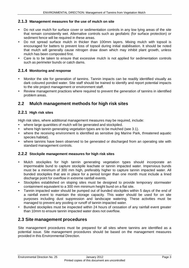
ENVIRONMENTAL DIRECTION: Management of Tannins from Vegetation Mulch
Environmental Direction No. 25 January 2012 Printed copies of this document are uncontrolled
Page 3
2.1.3 Management measures for the use of mulch on site
• Do not use mulch for surface cover or sedimentation controls in any low lying areas of the site
that remain consistently wet. Alternative controls such as geofabric (for surface protection) or sediment fence will be required in these areas.
• Do not spread surface mulch in thicker than 100mm layers. Mixing mulch with topsoil is encouraged for batters to prevent loss of topsoil during initial stabilisation. It should be noted that mulch will generally cause nitrogen draw down which may inhibit plant growth, unless mulch has been composted first.
• Care is to be taken to ensure that excessive mulch is not applied for sedimentation controls such as perimeter bunds or catch dams.
2.1.4 Monitoring and response
• Monitor the site for generation of tannins. Tannin impacts can be readily identified visually as
dark coloured ponded water. Site staff should be trained to identify and report potential impacts to the site project management or environment staff.
• Review management practices where required to prevent the generation of tannins in identified problem areas.
2.2 Mulch management methods for high risk sites
2.2.1 High risk sites
High risk sites, where additional management measures may be required, include:
• where large quantities of mulch will be generated and stockpiled.
• where high tannin generating vegetation types are to be mulched (see 3.1).
• where the receiving environment is identified as sensitive (eg Marine Park, threatened aquatic species habitat).
• where tannins have been observed to be generated or discharged from an operating site with standard management controls.
2.2.2 Stockpile management measures for high risk sites
• Mulch stockpiles for high tannin generating vegetation types should incorporate an
impermeable bund to capture stockpile leachate or tannin impacted water. Impervious bunds must be a minimum of 300 mm high, preferably higher to capture tannin impacted water. All bunded stockpiles that are in place for a period longer than one month must include a lined discharge point for overflow in extreme rainfall events.
• Stockpiles established on sloping sites must be designed to provide temporary stormwater containment equivalent to a 300 mm minimum height bund on a flat site.
• Tannin impacted water should be pumped out of bunded stockpiles within 5 days of the end of a rainfall event to maintain the storage capacity. This water should be used for on site purposes including dust suppression and landscape watering. These activities must be managed to prevent any pooling or runoff of tannin impacted water.
• Bunded stockpiles must be inspected within 24 hours of cessation of any rainfall event greater than 10mm to ensure tannin impacted water does not overflow.
2.3 Site management procedures
Site management procedures must be prepared for all sites where tannins are identified as a potential issue. Site management procedures should be based on the management measures provided in this Environmental Direction.

ENVIRONMENTAL DIRECTION: Management of Tannins from Vegetation Mulch
Environmental Direction No. 25 January 2012 Printed copies of this document are uncontrolled
Page 4
3 BACKGROUND
3.1 Tannin generation from vegetation mulch
See Plates 1 – 3 in Appendix 1.
Tannins are naturally occurring plant compounds. Tannin generation from vegetation mulch is likely to be highest from low-lying coastal floodplain areas. The species of vegetation (eg Melaleuca) will have a major impact on the likelihood of tannin generation.
Tannin generation is generally highest from mulched vegetation that is stockpiled in areas that are subject to inundation. Placement in wet areas will result in accelerated leaching of tannins into water, concentration of tannins in pooled water, and greater impacts on water quality.
3.2 Tannin impacts on water quality
See Plates 4 – 5 in Appendix 1.
The main concern with the discharge of water that is high in tannins is that it may increase the biological oxygen demand (BOD) of the receiving environment. Increases in BOD may result in a decrease in available dissolved oxygen. A lack of dissolved oxygen is identified as the main cause of about 80 percent of fish kills in NSW rivers and estuaries.
Tannin impacts may result in dark coloured water discharge from construction sites. This impact can be obvious and may raise the concern of the community and other stakeholders including regulatory authorities. Once discharged to the environment, tannins may reduce visibility and light penetration and change the pH of receiving waters. These impacts may affect aquatic ecosystems in receiving environments.
Tannins cannot be readily treated with standard construction site water quality controls. Once water on site is impacted with tannins it is not possible to treat effectively with currently approved flocculants. Minimisation of tannin generation in the first place is the management strategy that must be applied.
3.3 Use of mulch on construction sites
See Plates 10 – 16 in Appendix 2.
The RMS Biodiversity Guidelines provide guidance on the benefits of reusing various sizes of vegetation for different purposes. Mulch is a readily available and cheap source of material for temporary site stabilisation and sedimentation control. The re-use of mulch reduces the need to transport this material off-site and reduces handling and disposal costs for construction contracts.
Unprotected mulch sedimentation controls should not be placed in concentrated flow lines where mulch may be washed away. Mulch may be protected by wrapping it with geofabric or other materials to provide a stable control. All temporary catch dams constructed from mulch must have a stable outlet to minimise the washing away of mulch in high rainfall events, and the possible failure of the control.

ENVIRONMENTAL DIRECTION: Management of Tannins from Vegetation Mulch
Environmental Direction No. 25 January 2012 Printed copies of this document are uncontrolled
Page 5
4 ADDITIONAL RESOURCES
• RTA Biodiversity Guidelines- Protecting and Managing Biodiversity on RTA Projects, 2011
• Pacific Highway Mulch Protocol 2011

ENVIRONMENTAL DIRECTION: Management of Tannins from Vegetation Mulch
Environmental Direction No. 25 January 2012 Printed copies of this document are uncontrolled
Page 6
5 APPENDICES

ENVIRONMENTAL DIRECTION: Management of Tannins from Vegetation Mulch
Environmental Direction No. 25 January 2012 Printed copies of this document are uncontrolled
Page 7
Appendix 1: Plates showing tannin generation & water quality impacts
Plate 1: Melaleuca vegetation community – mulch from this vegetation type will generally produce
high amounts of tannins.
Plate 2: Vegetation mulching activity – mulch should be progressively moved into prepared
stockpile areas.
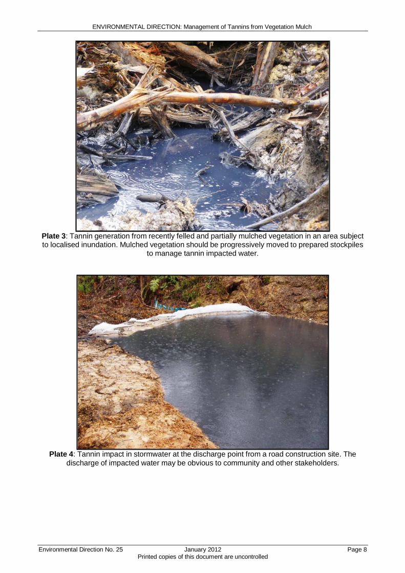
ENVIRONMENTAL DIRECTION: Management of Tannins from Vegetation Mulch
Environmental Direction No. 25 January 2012 Printed copies of this document are uncontrolled
Page 8
Plate 3: Tannin generation from recently felled and partially mulched vegetation in an area subject to localised inundation. Mulched vegetation should be progressively moved to prepared stockpiles
to manage tannin impacted water.
Plate 4: Tannin impact in stormwater at the discharge point from a road construction site. The
discharge of impacted water may be obvious to community and other stakeholders.
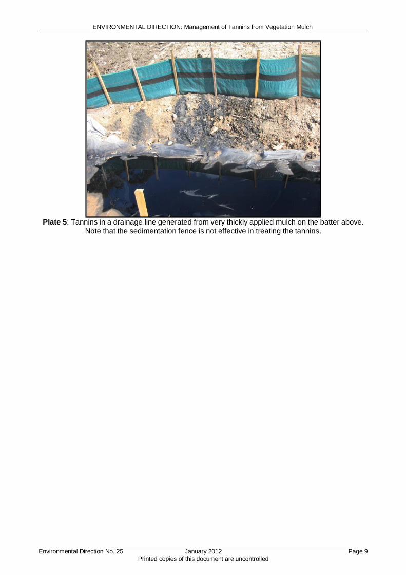
ENVIRONMENTAL DIRECTION: Management of Tannins from Vegetation Mulch
Environmental Direction No. 25 January 2012 Printed copies of this document are uncontrolled
Page 9
Plate 5: Tannins in a drainage line generated from very thickly applied mulch on the batter above.
Note that the sedimentation fence is not effective in treating the tannins.
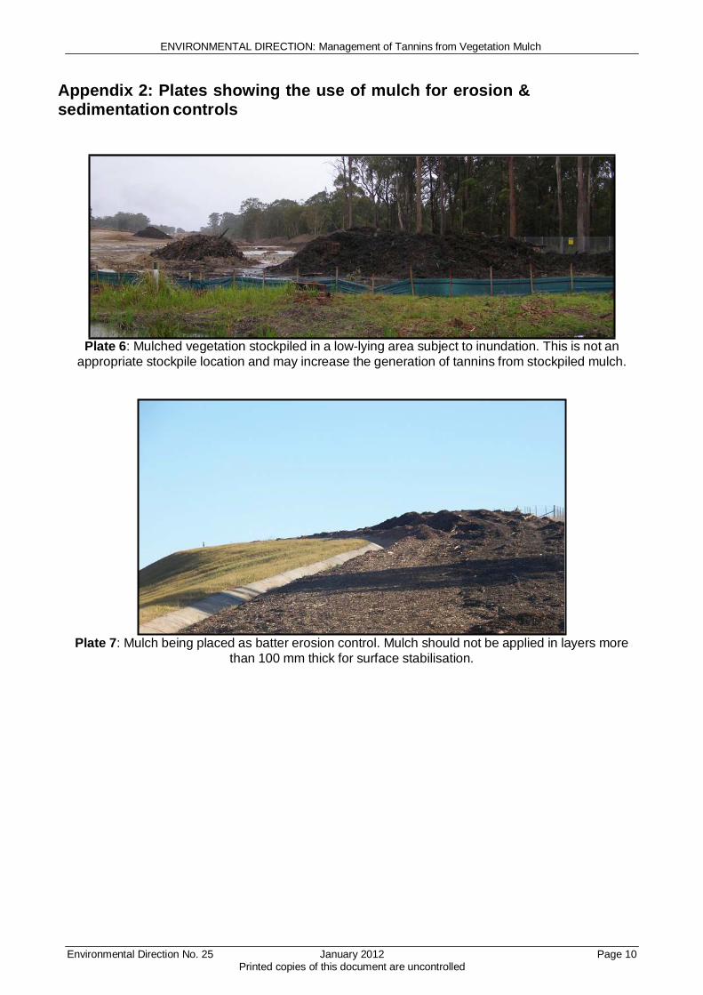
ENVIRONMENTAL DIRECTION: Management of Tannins from Vegetation Mulch
Environmental Direction No. 25 January 2012 Printed copies of this document are uncontrolled
Page 10
Appendix 2: Plates showing the use of mulch for erosion & sedimentation controls
Plate 6: Mulched vegetation stockpiled in a low-lying area subject to inundation. This is not an
appropriate stockpile location and may increase the generation of tannins from stockpiled mulch.
Plate 7: Mulch being placed as batter erosion control. Mulch should not be applied in layers more
than 100 mm thick for surface stabilisation.
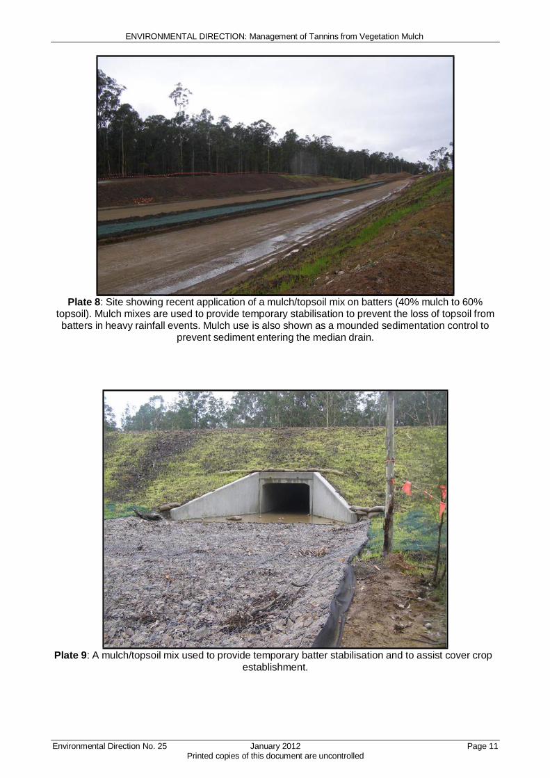
ENVIRONMENTAL DIRECTION: Management of Tannins from Vegetation Mulch
Environmental Direction No. 25 January 2012 Printed copies of this document are uncontrolled
Page 11
Plate 8: Site showing recent application of a mulch/topsoil mix on batters (40% mulch to 60% topsoil). Mulch mixes are used to provide temporary stabilisation to prevent the loss of topsoil from batters in heavy rainfall events. Mulch use is also shown as a mounded sedimentation control to
prevent sediment entering the median drain.
Plate 9: A mulch/topsoil mix used to provide temporary batter stabilisation and to assist cover crop
establishment.

ENVIRONMENTAL DIRECTION: Management of Tannins from Vegetation Mulch
Environmental Direction No. 25 January 2012 Printed copies of this document are uncontrolled
Page 12
Plate 10: Successful establishment of cover crops on batters where mulch has been used with topsoil to assist temporary stabilisation.
Plate 11: Geofabric wrapped mulch bunds used for sedimentation control

ENVIRONMENTAL DIRECTION: Management of Tannins from Vegetation Mulch
Environmental Direction No. 25 January 2012 Printed copies of this document are uncontrolled
Page 13
Plate 12: Mulch used as a bund for a temporary sedimentation catch dam. Mulch is effective as it
can provide both containment and filtering of site water. Mulch should not be used as a control in areas of concentrated flow where it may be washed away. Any mulch containment control should
have a defined and lined outlet that allows discharge from the control without washing mulch away. Note that this control does not have a defined discharge outlet which should be installed to prevent
failure of the control in heavy rainfall events.

ENVIRONMENTAL DIRECTION: Management of Tannins from Vegetation Mulch
Environmental Direction No. 25 January 2012 Printed copies of this document are uncontrolled
Page 14
Appendix 3: Minimum requirements for community mulch giveaways
The purpose of community mulch giveaways is to provide mulch for residential landscaping purposes.
The activities of a community mulch giveaway are permissible under the Protection of the Environment Operations (Waste) Regulation 2005 – General Exemption Under Part 6, Clause 51 and 51A (the Raw Mulch Exemption 2008). However, the activities remain subject to other relevant
environmental regulations within the Act and Regulations. The Raw Mulch Exemption 2008 is subject to the following conditions:
• The raw mulch can only be applied to land for the purposes of filtration or as a soil amendment material or used either singularly or in any combination as input material(s) to a composting process.
• The consumer must land apply the raw mulch within a reasonable period of time. Further information can be found at: www.environment.nsw.gov.au/resources/waste/ex08mulch.pdf
It is the mulch generators responsibility to ensure that the mulch is reused in an environmentally responsible manner.
A safe work method statement (SWMS) must be prepared that identifies potential OHS risks and all prevention and mitigation measures. The SWMS must apply to both the community and site workers involved in the mulch giveaway.
Each member of the community who participates in the mulch giveaway must read and understand a site specific information sheet. A template information sheet is attached as Appendix 4.
The site occupier must maintain written records for each load of mulch that is taken away and to ensure that each community participant understands the conditions of the community mulch giveaway information sheet. A suggested template to record this information is attached as Appendix 5.

ENVIRONMENTAL DIRECTION: Management of Tannins from Vegetation Mulch
Environmental Direction No. 25 January 2012 Printed copies of this document are uncontrolled
Page 15
Appendix 4: Community mulch giveaway information sheet
The following community mulch giveaway information sheet must be populated with site specific information.

Community Mulch Giveaway Information Sheet
Details of Mulch Supply
Site Occupier
<insert name of contractor / alliance etc>
Project Name
<insert project name>
Location
<insert location of mulch stockpile>
Mulch stockpile
access directions
<insert adequate directions for community members to find the stockpile location>
Background
• This information sheet supports the non-commercial giveaway of mulch for local residents.
• The product is raw vegetation mulch from <insert project location / name>.
Conditions
• Any one individual may only take a maximum of 5 trailer loads from this project.
• The mulch may only be used for residential landscaping purposes.
• Mulch must not be placed in or immediately adjacent to waterways.
• The raw mulch can only be applied to land for the purposes of filtration or as a soil amendment material or used either singularly or in any combination as input material(s) to a composting process.
• The consumer must apply the raw mulch to land within a reasonable period of time.
Community Safety Requirements
• <add in any safety requirements or mitigation measures from the SWMS that apply to the
community>
• <add in any safety requirements or mitigation measures from the SWMS that apply to the
community>
• <add in any safety requirements or mitigation measures from the SWMS that apply to the community>
• <add in any safety requirements or mitigation measures from the SWMS that apply to the
community>

ENVIRONMENTAL DIRECTION: Management of Tannins from Vegetation Mulch
Appendix 5: Records template for community mulch giveaway
The records in the following suggested template must be kept as a minimum.
Environmental Direction No. 25 January 2012 Page 17
Printed copies of this document are uncontrolled

Community Mulch Giveaway Record Sheet
Date
Car Registration
I have read and understand the ‘Community Mulch
Giveaway Information Sheet’
Name
Signature
D Yes
D Yes
D Yes
D Yes
D Yes
D Yes
D Yes
D Yes
D Yes
D Yes
D Yes


Appendix E Groundwater Management Strategy
Note: This Appendix is not applicable to the Wave 2 Project and therefore has been intentionally omitted.

Appendix F Unexpected Discovery of Contaminated Land Procedure

Appendix G Pacific Highway Projects Dewatering Practice Note
Appendix H Sediment Basin Management and Discharge Procedure
Note: This Appendix is not applicable to the Wave 2 Project and therefore has been intentionally omitted.

Appendix I Stockpile Management Protocol
Appendix J Emergency Spill Response Plan

Appendix K Groundwater and Soil Salinity Report
Note: This Appendix is not applicable to the Wave 2 Project and therefore has been intentionally omitted.
Appendix L Oxleyan Pygmy Perch Habitat Waterway Management Framework
Note: This Appendix is not applicable to the Wave 2 Project and therefore has been intentionally omitted.
Appendix M Hydrological Mitigation Report

Appendix N Schedule of property specific management measures