appendix b - montgomery county, maryland · response to agency comment letters appendix b response...
TRANSCRIPT

A-251
A-2
60
A-302
A-3
04 Future
Interchange
(Futu
re E
xte
nsio
n)
A-1
9
OBSERVAT
ION
DR
.
NEW
CUT
A-306
A-3
05
ROAD
EXTENDED
I-1
I-4
M-2
7
I-1
A-298
A-2
97
A-1
7
BRINK
ROAD
BRINK
RD.
WIG
HTM
AN
RD.
RIDGE
ROAD
FRED
ERIC
K
VIL
LAG
E
AVE.
MONTG
OM
ERY
COU
HIGHWAY
MIDDLE
ROAD
ROOKB R
OA
D
MAN
GO
SH
EN
RO
AD
LD
CENTERWAY RD.
WATKINSM
ILL
ROAD
117
RO
AD
CLARK
SBU
RG
FREDERIC
K
ROAD
FA
TH
ER
HURLEY
BLV
D.
Shady GroveMetro Station
MA
TE
NY
RD
.
RIC
HTER
FARM
RD
.
LEAMAN
FARM
RD.
CLOPPER
ROAD
DAW
SON FA
RM
ROAD
WIS
TERIA
DRIV
E
WA
RIN
GS
TAT
ION
RD
.
GR
EA
T
SENECA
HW
Y.
SHAKESPEARE BLVD.
OB
DR.
SE ARV TIO
NDR.
CRYSTAL
ROCK
DR
IVE
OBSERVATION
STRINGTOW
N
BALTIMORE
BURNT
HIL
LROAD
FOREMAN
BLVD.
SC
EN
ER
Y
DR
.
LO
NG
DR
AFT
RO
AD
ASPH
AN
T
E
RUN
DR
.
A-1
4
CENTURY
BLV
D.
ICKRD.
WOODFI
ELDROAD
SN
OU
FFE
R
SCHOOL
WASH
INGTO
N
GROVE
RD
.
WEST DIAMONDAVE. EAST
ROAD
WO
OD
FIE
LD
RID
GE
RO
AD
RO
AD
ARD
QUIN
CE
GREAT
WAY
SENEC
A
MU
DD
Y
BRANCH
RO
AD
RIF
FLE
FORD
ROAD
CR
AB
BS
BR
AN
CH
SHADY
ROAD
GR
OV
E
WAY
119
DRIVE WEST
GUDE
KEY
WEST
AVE.
SH
AD
Y
RO
AD
GR
OV
E
TOW
N
SA
M
EIG
HWY.
GAITHER
RO
AD
BLVD.
REDLAND
DR
IVE
PIC
CA
RD
RO
AD
FREDERICK
REDLAND
RO
AD
NEEDWOOD ROAD
ROAD
ROAD
M-83
ROAD
Gaithersburg
Clarksburg
MIDNTY
TOW
N
GER
RO
AD
RFIEWA
Germantown
HIG
H
ORC
DARNES
SN
OW
DEN
FA
RM
PKWY.
metroM
RD.OLDWEST
H
RO
AD
BLUNT
WA
YFA
RE
R
RD
.
E
W
TS
D
200
FutureInterchange
UnderConstruction
Future Completionby Developers
UnderConstruction
Future Completionby Developers
N
S
EW
N
S
EW
355
27270INTERSTATE
270INTERSTATE
270INTERSTATE
370INTERSTATE
355
124
124
124
119
119
28
28
118
117
124
112
121
9
8
8/9D8/9A
8/9B5
4MODIFIED
Alt 2
Alt 4 Modified
Alt 5
Alt 8
Alt 9
Alt 8/9A
Alt 8/9B
Alt 8/9D
LegendAlternatives Retained for Detailed Study
115
355
AP
PE
ND
IX B
RESPONSE TO AGENCY COMMENT LETTERS
APPENDIX B
Res
pons
e to
Age
ncy
Com
men
t Let
ters


1
Montgomery County Department of Transportation
Response to U.S. Army Corps of Engineers Letter, Dated November 19, 2013 February 4, 2014
1. Please submit your responses to the enclosed public/agency comments.
Response: In the body of the USACE letter, the USACE has summarized in a few short pages the types of comments and nature of comments provided by the general public. In addition, the USACE references letters from agencies that include comments regarding the Draft Environmental Effects Report (DEER) for this project and the public hearing documents, these include:
• Maryland Department of the Environment (MDE) dated December 12, 2013 • U.S. Environmental Protection Agency (EPA) dated August 20, 2013 • The City of Gaithersburg dated July 17, 2013
Separate responses to each of the EPA letter and the City of Gaithersburg letter are enclosed. By carbon copy, USACE will also be forwarded a copy of responses to the MDE letter. Additionally, a response to the August 23, 2013 letter from Montgomery County Public Schools is included in response #11 of our responses to the MDE letter. General comments from the public were summarized in the USACE letter and will be considered in the selection of a preferred alternative. The MCDOT has reviewed the copy of public comments provided by USACE and MDE. MCDOT agrees with the USACE summary, provided in their November 19, 2013 letter. This summary adequately and appropriately captures the breadth of commenters and the nature/content of the comments received from the public. In addition, specific concerns raised by the general public were expanded upon in detailed comments number 1 through 18 in the USACE letter and number 1 through 8 in the MDE letter. The USACE indicated that some reviewers commented that the DEER is biased toward the Master Plan Alignment (a new road build alternative) and does not consider transit options or consider the benefits of combining non-new alignment options with other road improvements and transit options in the area. MCDOT has considered these “alternatives” and provided additional information in our detailed responses and will include a discussion of these non-ARDS “alternatives” in the PA/CM report. As with other high profile projects in Montgomery County, many of the letters received are repetitive/form letters from members of active community groups. All comments from the public and groups have been considered and will be responded to within the context for the Final EER. In November, 2013, the Montgomery County Planning Board conducted an additional advertised public meeting regarding the Midcounty Corridor Study specifically to hear from the M-NCPPC and MCDOT staff regarding the alternatives and to allow the public to comment (provide testimony regarding the proposed project and alternatives) during the meeting. Subsequently, the Planning Board provided a position on behalf of MNCPPC regarding a preferred alignment based on all of the testimony and record/information compiled to date. The Planning Board considered input from the public at the meeting, the public comments from the USACE/MDE public meeting, and presentations from their technical staff in making a recommendation for a preferred alternative for this project. A copy of the Montgomery County Planning Board letter which documents their recommendation for a preferred alternative is attached (Attachment A).

MCDOT’s Response to USACE’s November 19, 2013 Letter February 4, 2014
2
2. Please include an evaluation of the Alternative 4 Modified alignment limited to the currently reserved right-of-way in an analysis of other possible combinations with the alternatives (e.g., Alternatives 4 Modified alignment with 80’ ROW combined with Alternative 5 and 2).
Response: Limiting the typical section of Alternative 4 Modified to an 80' ROW would require elimination of key elements such as bike lanes, sidewalk, shared use path, buffer strips and/or medians that are essential for the roadway to meet the project purpose and need. For instance, we would not eliminate or reduce the width of the bike lanes, sidewalk and/or shared use path since they are critical to providing safe and effective pedestrian and bicycle travel along the corridor. Buffer strips between the curb and sidewalk/bikepath are already at a minimal width of 3.5 feet. The 5 foot buffer width behind the bikepath/sidewalk could potentially be reduced to 2-3 feet but this would have a very minor effect on impacts while reducing the viability of sustaining healthy street trees along the corridor. In addition, reducing the right of way would not enhance the operational and safety concerns associated with the numerous driveways, increased potential for vehicular incidents, and the potential conflicts with school children who will need to cross four to six lanes of traffic to reach their school bus stop. In summary, we do not feel a reduced Alternative 4 Modified typical section is a viable alternative since it would not adequately meet the purpose and need of the project. We do not recommend it as a stand-alone alternative or in combination with other alternatives.
3. Please respond to the Woodland Hills Home Owners Association and other citizens
concerns regarding air quality and Alternative 9's close proximity to Watkins Mill Elementary School by addressing if there is any increase in respiratory-related health issues in school children in similarly situated schools (e.g., those located along Great Seneca Parkway and the lntercounty Connector). Please describe which air pollutants would be most likely to affect an adjacent school and children and, if possible, evaluate each of the alternatives likelihood to pose such an air quality health risk.
Response: We are unaware of any data that can answer the question if there are any increases in respiratory-related health issues in school children in similarly situated schools along transportation improvements such as those on Great Seneca Parkway and Inter County Connector. Additionally, we are not aware of any conclusive studies conducted regarding increases in respiratory-related health issues from air quality changes resulting from transportation improvements adjacent to schools in general. Air pollutants that would be most likely to affect children at schools adjacent to highways were evaluated and described in detail in the DEER in Section 6. We refer you to the discussion in the chapter on the various pollutants regulated according to the Clean Air Act, the assessments made for this project and the results. Pollutants of concern assessed are contained in Table 6-1 and Table 6-2 including current attainment status and concentrations in Montgomery County. As described in this section of the DEER, neither the current condition nor the proposed condition of the alternatives studied generate exceedances of the National Ambient Air Quality Standards (NAAQS) air quality standards. Refer to Table 6-3 through Table 6-10. The Air Quality assessments were conducted following standard NEPA/CAA protocols with the following general basis of understanding:

MCDOT’s Response to USACE’s November 19, 2013 Letter February 4, 2014
3
Risk Assessment • Federal and state agencies agree that air pollution from vehicles can affect the
health of individuals and have implemented NEPA, the Clean Air Act (CAA/CAAA90) and Federal Regulations.
• CAA/CAA90 requires EPA to establish National Ambient Air Quality Standards (NAAQS) for criteria pollutants based on substantial research to protect public health and welfare, including “sensitive” populations such as asthmatics, children and the elderly.
• 40 CFR 1502.22 provides requirements concerning unavailable or incomplete information, such as the health effect risks on residents adjacent to highways.
• The Midcounty Corridor Study air quality analyses were completed in conformance with NEPA, CAA/CAAA90 and 40 CFR 1502 per EPA and FHWA guidance.
In summary, air quality studies conducted for pollutants of concern to asthmatics and children (such as CO and PM2.5) demonstrated that NAAQS will not be exceeded at communities and schools adjacent to the project for all alternatives considered.
4. Please address comments concerns about bridge elevations, shading, and conversion of wetlands, streams, and riparian areas located below any proposed bridges. Also, please address any construction best management practices (e.g., timber matting, grubbing but no clearing, additional mulch layers) to help assure construction activities do not permanently impact access areas. Please be advised that the Corps would require inspection and confirmation that all temporary impacts associated with construction are fully restored as part of any authorization compliance. Response: MCDOT understands that bridges over the wetland crossings may induce conversion impacts, particularly where the alternatives are crossing forested wetlands. Our engineers and scientists have been sensitive to the potential impacts at the proposed bridge crossings and have provided substantial vertical clearance at the majority of the crossings in an effort to reduce shading impacts. Of course, where proposed bridges span forested wetlands, impacts to the forests cannot be completely avoided and conversion impacts have been included and accounted for in the wetland impact area computations. However, we feel the clearances provided during the preliminary engineering of the alternatives are reasonable and provide opportunity to sustain newly converted emergent wetlands. Of course, we realize the “right vertical clearance” is not an exact science, and we will collaborate with the agencies during the final design of the preferred alternative to further refine the proposed bridge layouts and profiles to provide a design that enhances the ability to sustain wetlands and riparian buffer below the proposed bridges. These efforts will include follow up monitoring of effects for possible adjustments. A wide variety of construction best management practices, including matting, mulching, limited clearing/grubbing, specialized equipment, and specific construction sequencing/phasing will be investigated and implemented during final design of the preferred alternative to minimize construction impacts and ensure that the construction activity impacts are temporary, rather than permanent. Temporary impact limits will be identified in greater detail for the preferred alignment once selected, and MCDOT will identify appropriate best management practices for construction in environmentally sensitive areas such as streams, wetlands, and riparian areas for the preferred alignment. We will also investigate recent experiences and successes on other transportation improvement projects and evaluate their potential application on this project. MCDOT acknowledges that

MCDOT’s Response to USACE’s November 19, 2013 Letter February 4, 2014
4
full restoration of the temporary construction impacts is a primary objective and will be required by the Corps, and the County is prepared to respond cooperatively to those requirements.
5. Please provide additional information on the transit options already being
implemented by the county within the study area. In addition, please provide any additional information about a possible BRT system along MD 355 and Alternatives 8 and 9. Please address the comments that combining Alternative 2 with other alternatives or adding transit like a BRT system to other alternatives could reduce the amount of travel capacity necessary for Alternative 9. Also, please update transit options within the study area respective to the recently approved State funding approvals for projects in Montgomery County.
Response: The County Executive and County Council have expressed in writing to the State Delegation and the MDOT Secretary that their transit priorities consist of continued support for the operation and funding of the Metro System, the construction of the Purple Line and the Corridor Cities Transitway (CCT). The Purple Line and CCT are currently being developed by the Maryland Transit Administration (MTA) within Montgomery County. The Purple Line is a proposed 16-mile light rail line extending from Bethesda in Montgomery County to New Carrollton in Prince George's County. The line will provide a direct connection to the Metrorail Red, Green and Orange Lines; at Bethesda, Silver Spring, College Park, and New Carrollton. The Purple Line will also connect to MARC, AMTRAK, and local county bus services. The Purple Line is located southeast of the study area but is connected to the study area by the Red Line route which terminates at the Shady Grove Metro Station. The project is planned to start construction in 2015 with service to begin in 2020. The project is funded for final design and right-of-way acquisition and MTA is currently pursuing federal funding for construction. Current total cost estimate for the project is $2.4 Billion, which are not yet secured. The second major transit improvement being developed at the western limits of the study area along I-270 is the Corridor Cities Transitway, a proposed 15-mile bus rapid transit (BRT) system between the Shady Grove Metro Station and the COMSAT facility near Clarksburg (Attachment B). The project has two phases. Phase I is the initial 9 miles from Shady Grove to Metropolitan Grove; this Phase is currently under development and is proceeding with engineering and environmental analysis and is funded for formal environmental documentation, final design, and right-of-way acquisition. Phase II is the future extension from Metropolitan Grove to the COMSAT facility, and will be completed with planned development and the availability of additional transportation funding. Neither phase is currently funded for construction. Estimated total cost for phase 1 is $ 545 Million and an additional $285 Million for phase 2.
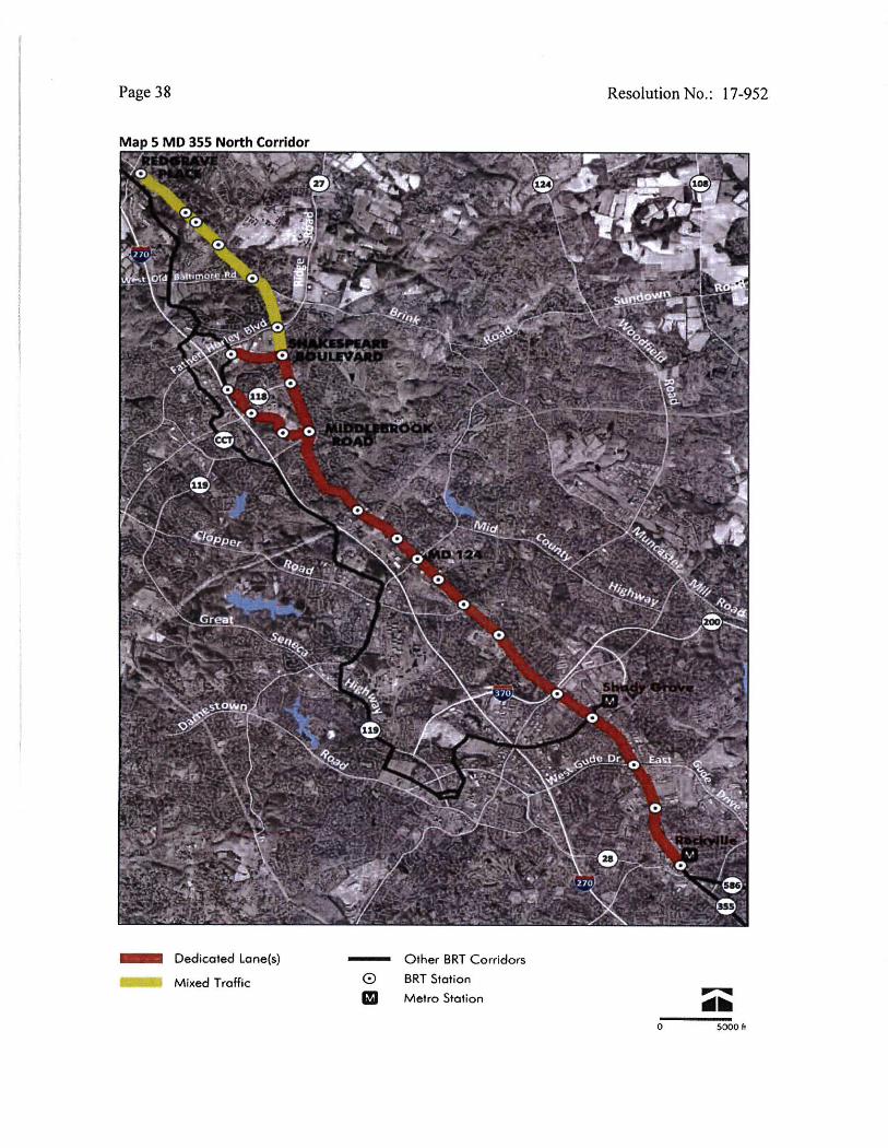
In addition to the two MTA led projects described above, M-NCPPC has recently completed the Countywide Transit Corridors Functional Master Plan (CTCFMP), which identifies a planned 80 mile BRT network comprising 10 corridors and the Corridor Cities Transitway (Attachment B). The CTCFMP was just recently approved and adopted by the County Council on November 26, 2013. Two of the ten proposed corridors in the network are located along MD 355 and are identified as MD 355 North and MD 355 South. MD 355 South is located south of the study area and extends 8 miles along the MD 355 corridor between the Bethesda Metro Station and the Rockville Metro Station. The Master Plan generally recommends separate dedicated lanes for this Corridor, which is south and outside the study area.

MCDOT’s Response to USACE’s November 19, 2013 Letter February 4, 2014
5
MD 355 North extends approximately 12 miles from the Rockville Metro Station to Redgrave Place in Clarksburg; the portion located north of Shady Grove Road is located within the study area. The northern segment of the transitway between Redgrave Place and Shakespeare Boulevard is master planned to operate within mixed traffic on existing travel lanes. South of Shakespeare Boulevard, the system is generally master planned as a separate dedicated two-lane median transitway comprised of 4 travel lanes and 2 transit lanes. The planned lane configurations for portions of the MD 355 North corridor are typically based on repurposing 2 of the existing 6 travel lanes on MD 355 as dedicated transit lanes. However, it is important to note that the lane configurations are preliminary and the final lane determinations would be based on a detailed assessment of estimated ridership, operations, traffic analysis and potential environmental and community impacts. Current county funding is supporting preliminary studies of BRT along the Georgia Avenue and Veirs Mill Road corridors by MTA/SHA. The County also plans to initiate studies of the “high priority” corridors along MD 355 South, Randolph Road and US 29 with $10M in state funds made available from the new state gas tax revenues. While various residents, coalitions and agency representatives have suggested that BRT be studied as an alternative to the roadway improvement alternatives currently included in the MCS, the County Master Plan does not view BRT as a substitute alternative to the proposed roadway improvements but as a transit improvement that should further enhance travel in the study area. It is important to note that Midcounty Highway (Alternative 9A) remains within the County master plans as a key transportation element to support planned growth within the study area. The proposed roadway improvement alternatives in the MCS provide numerous transportation benefits that cannot be solely provided by MD 355 BRT alone including additional capacity, improved safety, accommodation of planned growth, improved travel times and improved mobility for all. Of special importance for the safety and security of the community is the improved response time for police services and emergency vehicles. The capacity of MD 355 BRT, for example, cannot replace the capacity provided by a new 4-lane arterial highway (the Master Planned Alternative 9). Furthermore, a significant portion of the MD 355 BRT corridor is intended to be implemented by repurposing 2 of the existing 6 travel lanes, which of course will reduce automobile capacity within the study area. Consequently, BRT would potentially need to provide capacity and attract ridership that is equivalent to the 2 repurposed lanes on MD 355 as well as the 4 lanes associated with the Master Planned Midcounty Highway. The daily ridership estimates (approximately 21,500) for the MD 355 North BRT are less than one half the estimated daily traffic volumes on the proposed Mid County Highway by 2040. Furthermore, half of the estimated ridership on MD 355 BRT will be people who are currently using existing transit facilities, clearly indicating that the BRT cannot meet the estimated traffic demand of the proposed project. Finally, the ability to fund and implement MD 355 BRT North would be highly unlikely in the near future due to its location beyond the County’s urban core since the initial high priority corridors have been identified as US 29, Randolph Road and MD 355 South. Implementation of the MD 355 North BRT would likely take many years to fund since it is located behind miles of other stated higher priority corridors that will require many years and several hundred million dollars in funding to design, construct and operate. So in summary,

MCDOT’s Response to USACE’s November 19, 2013 Letter February 4, 2014
6
MD 355 BRT is a long term transit improvement that will further enhance transportation in the study area but that will not serve as a substitute for the master planned roadway improvements.
6. Please provide additional information about the current and proposed future status of the Shady Grove Metro station. Specifically, address comments that the station is already at capacity (parking and train) and does not offer a transit solution for travelers who would utilize a build alternative to take transit from the Shady Grove metro. Response: WMATA recently outlined their plan to increase station access in the Shady Grove Station Access Improvement Study Final Report, July 2011. The report indicates that Metro anticipates a 45% increase in ridership at the station over the next 20 years. Furthermore, Metro owns approximately 60 acres of land with development potential at the Shady Grove station and anticipates that this land will be developed in partnership with the County and the State under the joint development program. The goals of the proposed improvements would include creating transit oriented development that is comprised of walkable mixed used communities and which integrate the transit facilities to reduce auto dependency. Implementing this plan will also require redevelopment of Metro’s property including reconfiguring the Metro bus, Kiss and Ride and parking facilities to meet the demands of the proposed development and future growth in station ridership.
7. Please update information concerning the Watkins Mill interchange at I-270 and any potential ramification for the study area and proposed project. Response: The Watkins Mill Road / I-270 Interchange project is fully funded for construction by SHA and is currently scheduled to be built between Winter 2016 and Fall 2018. The project’s Preliminary Investigation (30% design) was held in November 2012 and a Value Engineering study was completed in January 2013. SHA is currently proceeding towards completion of Semi Final Plans (65% Design) in May 2014. While we have not specifically studied the effects of this project on the study area, we would anticipate that it will help to reduce traffic volumes on the adjacent east-west roadways – Quince Orchard Road and Montgomery Village Avenue – and will, therefore, help reduce congestion at the intersections of Quince Orchard Road and Montgomery Village Avenue with MD 355 and improve operations of the existing Interchange of I-270 at Quince Orchard Road.
8. Please clarify if M-83 would be a state or county controlled road if constructed. Please provide additional information about MD SHA control roads in the study area (e.g., I-270 and MD 27) and future improvements requested by the County. Response: M-83 would be paid with 100 percent County funds and therefore, it will be a county designed, built, maintained and operated roadway if constructed. Programmed improvements for other local roadways in the study area are identified under the No-Build Alternative on page 2-13 of the Draft EER. In regard to local SHA roadways:

MCDOT’s Response to USACE’s November 19, 2013 Letter February 4, 2014
7
• I-270 is planned to be widened to six lanes (a single HOV lane in each direction) between MD 121 in Clarksburg and MD 85 in Frederick. This project is currently on hold and is not funded for design, right of way acquisition or construction by SHA.
• MD 355 is not programmed for any further improvements by SHA. • MD 27 is programmed to be widened to six lanes between Brink Road and Snowden
Farm Parkway as a condition of development within Clarksburg. Completion of this project is expected within the next five years.
• MD 124 (Woodfield Road) is programmed to be widened to six lanes between Midcounty Highway and Airpark Road (Phase 2) and from Fieldcrest Road to Warfield Road (Phase 3). Design-build documents for Phase 2 are scheduled for completion by Summer 2015. Montgomery County has committed $5M towards this project for design and right-of-way acquisition. The project is not funded for construction.
• Phase 2 of the Corridor Cities Transitway along the western side of MD 355 has been under study by the MTA. Design, right of way acquisition and construction has not yet been programmed by the County or the State.
• It is important to note that the traffic modelling for the Midcounty Highway project considered that all of these projects will be completed by 2040. If there is not sufficient funding for their implementation, the need for the M-83 project would be even greater.
9. Please address the environmental justice concerns raised in EPA's comment letter.
Response: A separate response to the EPA's comment letter dated August 20, 2013 is enclosed. This response addresses the environmental justice concerns raised by EPA.
10. Please address the concerns raised by citizens in the Fetrows neighborhood,
Wacomor Drive, and Ward Avenue regarding traffic concerns and Alternative 9.
Response: Wacomor Drive and the Fetrows neighborhood are located on the east side of Ridge Road approximately 1 mile north of the proposed intersection of Midcounty Highway and Ridge Road. The community has expressed concern with difficult access from Wacomor Drive as a result of high traffic volumes on Ridge Road. This issue is an existing intersection access issue that could potentially be improved through supplemental intersection improvements (such as left turn lanes, medians, signing, signalization, etc.). Since Ridge Road is a state roadway (MD 27), this issue should be addressed separately by the community through the Maryland State Highway Administration (SHA) District 3 Office.
11. Please address the City of Gaithersburg comments.
Response: A separate responses to the City of Gaithersburg comment letter dated July 17, 2013 is enclosed.
12. Please include aspects of community disruption and fragmentation in the quality of life analysis for each alternative. Response: The DEER contains discussion on community disruption and fragmentation for each alternative. The information is “threaded” throughout the document in various sections. The information will be consolidated into a quality of life analysis section of the FEER if desired by the USACE. Inherent in the Montgomery County Master Plan development process is the goal to prevent/avoid community disruption and fragmentation in the quality life. Infrastructure improvements are identified in the plan and must be approved

MCDOT’s Response to USACE’s November 19, 2013 Letter February 4, 2014
8
in the plan before implementation. Infrastructure improvements, such as roads/highways, in the plan are based on serving the needs of the development identified in the plan. Road improvements in Montgomery County therefore are meant to provide the cohesion necessary for the plan elements to work and to avoid unexpected disruptions in the community.
13. Please clarify if impact fees are collected from development in Clarksburg and if any are dedicated to transportation projects. Please clarify what type of development is allowed within the Agricultural Preserve, parkland, and Special Protection Areas within the study area. Response: By Montgomery County Code, Chapter 52, Article 7, Montgomery County imposes "development impact taxes" on new development to help pay for transportation and public school improvements necessitated by the new development, including the Clarksburg area. Under the law, developers can get “impact tax credits” in lieu of paying the tax, if they build transportation infrastructure that meets certain criteria. For example, impact tax credits have been instrumental in completing the construction of Snowden Farm Parkway in Clarksburg Village by Elm Street Development and the Artery Group. The extent to which impact taxes may be used to fund the design and construction of the proposed Midcounty Highway project have not yet been determined. All school impact taxes are devoted to school construction. The undeveloped properties north of Brink Road located within the Agricultural Reserve are currently zoned Rural Density Transfer (RDT), as are the Woodfield Farm and Benson-Sibley Farm. Types of potential development that are permissible for RDT zoning are presented within Section 7.1 of the Draft EER. The Montgomery County Planning Department has indicated that Alternative 4 Modified or a master plan alternative that includes Northern Terminus Option D could result in some development pressure within the Agricultural Reserve. However, the likelihood of significant additional development being approved appears remote when considering the stringent state and county regulations that affect development within the Agricultural Reserve. Further, land use and development in the Agricultural Reserve and in greenways and land to be dedicated for Parks (Dept. of Parks) is strictly regulated and limited by specific land use and zoning provisions. Any development of parkland, for instance, must be consistent with Vision 2030; Strategic Plan for Park and Recreations in Montgomery County, MD (2011). Within Special Protection Areas, special measures - especially around construction sites - are implemented to protect natural resources and features that may be affected by the construction. As outlined on page 7-4 of the Draft EER, these measures include:
• Establishing and enforcing imperviousness restrictions on future development within the SPA.
• Providing compensating BMPs for increased imperviousness in sensitive watersheds and SPAs; and
• Expanded wetland buffers in SPAs of up to 150 feet for wetlands on first and second order streams in Use III watersheds, 75 feet on first and second order streams in Use IV watersheds, and 50 feet on first and second order streams in Use I watersheds.
Further, all development, including county road projects, taking place in Special Protection Areas must develop a water quality plan to be approved by the Planning Department and Department of Permitting Services. The water quality plan addresses environmental

MCDOT’s Response to USACE’s November 19, 2013 Letter February 4, 2014
9
sensitive design, minimization of imperviousness and forest conservation while maximizing sediment control and stormwater management.
14. Please clarify if the proposed project will include environmental stewardship projects. Response: Upon selection of a preferred alternative, MCDOT will begin working with other Montgomery County agencies and departments to identify potential environmental stewardship projects associated with the proposed improvements.. As the project is 100 percent locally funded, the extent of the stewardship will be based on the funding appropriations approved by the County Council. Extensive coordination has already occurred with the MNCPPC, Corps, and MDE regarding potential mitigation and stewardship projects on parklands for park, wetlands, stream, forest and FIDS resource enhancement in the area. MCDOT will continue this effort as outlined by MNCPPC in its November 25 letter supporting continued discussion on appropriate environmental stewardship projects within this project corridor.
15. Please correct labeling errors on maps in the DEER as noted in citizen's comments. Response: Labeling errors on maps will be corrected in future submittals including the PA/CM and FEER.
16. Please provide information of the alternative potential impacts to Green Infrastructure (e.g., hubs and corridors) within the study area and forest interior dwelling bird habitat. Response: Green Infrastructure and FIDS impacts occur in the Great Seneca Creek and Cabin Branch stream valley corridors for some of the ARDS. Alternative 2 contains no impacts to Green Infrastructure or FIDS habitat. Alternative 4 impacts Green Infrastructure where widening the existing roadway crosses the corridor of Cabin Branch Stream Valley Park (Snouffer School Road) and the hub of Great Seneca Stream Valley Park (Wightman Road). Green infrastructure impacts for Alternative 4 total 6.23 acres, including 2.17 acres of FIDS impacts. These impacts occur along the existing FIDS buffer at Cabin Branch (774 sf), Great Seneca (13,241 sf), and the forest area east of Woodfield Road (80,671 sf). Alternative 5 will not impact Green Infrastructure or FIDS since no road widening will occur at the existing bridge crossing of Great Seneca Stream Valley Park (Frederick Road – MD 355). Alternatives 8 and 9 impact Green Infrastructure at the proposed alignment crossing of Great Seneca Creek (hub) and northeast of Middlebrook Road in the Brandermill Tributary area totaling 25.9 acres. In addition, Alternatives 8 and 9 Northern Terminus Options will have the following Green Infrastructure impacts:
• Northern Terminus A: Great Seneca Stream Valley Park (hub) along Dayspring Creek at North Germantown Greenway Stream Valley Park -- 23.6 acres.
• Northern Terminus B: Great Seneca Stream Valley Park (hub) along Dayspring Creek at North Germantown Greenway Stream Valley Park -- 15.9 acres.
• Northern Terminus D: Great Seneca Stream Valley Park (hub) along Dayspring Creek at North Germantown Greenway Stream Valley Park -- 15.7 acres.
Alternatives 8 and 9 impact FIDS and FIDS buffer at the crossing of Great Seneca Creek and northeast of Middlebrook Road in the Brandermill Tributary area (921,511 sf) and at Whetstone Run, NW of the PEPCO property (78,185 sf), resulting in FIDS and FIDS buffer

MCDOT’s Response to USACE’s November 19, 2013 Letter February 4, 2014
10
impacts of nearly 23 acres. In addition the Alternatives 8 and 9 Northern Terminus Options will have the following FIDS and FIDS buffer impacts:
• Northern Terminus A: Great Seneca Stream Valley Park along Dayspring Creek at North Germantown Greenway Stream Valley Park – 60.6 acres.
• Northern Terminus B: Great Seneca Stream Valley Park along Dayspring Creek at North Germantown Greenway Stream Valley Park – 42.19 acres.
• Northern Terminus D: Great Seneca Stream Valley Park along Dayspring Creek at North Germantown Greenway Stream Valley Park and the Wilson Property– 46.7 acres.
17. Please clarify whether roadway intersections on the alignments are viewed as
increased transportation system connectivity or traffic delay points for each alternative. Response: Roadway intersections on the alignments represent opportunities for connectivity to the surrounding roadway network but also act as conflict points which can cause traffic delay. The objective in transportation design is to provide a network of different roadway classifications (expressways, arterials, collectors, and local roads) that have varying degrees of access control (driveways to homes and businesses), varying numbers of intersections and distance between intersections. A properly balanced roadway network, with different road classifications, will allow for safe and efficient travel for all modes of traffic for various types of trips throughout the study area.
18. Please note that in accordance with the Corps/EPA Compensatory Mitigation Rule, prior to a permit decision, the Corps must approve a final mitigation plan to compensate for the permanent impacts to waters of the U.S., including jurisdictional nontidal wetlands. In addition, permanent conversion of waters of the U.S., including jurisdictional nontidal wetlands, may also require compensatory mitigation. Functional assessments will be required for all proposed impacts to waters of the U.S. and any compensatory mitigation requirements will be based upon full replacement of permanently impacted (including conversion) aquatic resources. Response: MCDOT understands that a final mitigation plan will be required prior to a final permit decision. We anticipate completing the mitigation plan upon selection of a preferred alternative when final impacts to jurisdictional waters including wetlands can be determined for the preferred alternative. MCDOT will continue to work with USACE and MDE to confirm compensatory mitigation requirements based on impact calculations and the applicable functional assessments. Since functional assessments are required for all proposed impacts to Waters of the US, including wetlands -- we propose that functional assessments be carried out according to The Highway Methodology Workbook Supplement by the USACE New England District.

MCDOT’s Response to USACE’s November 19, 2013 Letter February 4, 2014
ATTACHMENT A


MCDOT’s Response to USACE’s November 19, 2013 Letter February 4, 2014
ATTACHMENT B


1
Montgomery County Department of Transportation
Response to Maryland Department of the Environment Letter, Dated December 12, 2013 February 4, 2014
1. Please elaborate on how projected traffic improvements made a distinction between
the current traffic condition, versus the additional traffic generated by future business and residential development. To what degree would a new road relieve current rush hour problems, as opposed to facilitating additional development which will exacerbate traffic issues?
Response: One of the four purposes for Midcounty Corridor transportation improvements (as stated in the Midcounty Corridor Study Purpose and Need document) is “to relieve projected congestion on roadway facilities between Clarksburg and Gaithersburg, east of I-270.” Consequently, we have not specifically analyzed the effects of the ARDS on current traffic operations. Nonetheless, we would anticipate a significant reduction in the current congestion following the implementation of any of the alternatives retained for detailed study (ARDS). Traffic analyses for the preferred alternative will be completed prior to final design to ensure satisfactory traffic operations for the year that the new roadway improvements are planned to be placed in service. The approved regional travel demand model used to forecast the future traffic volumes for this study is based on household, population, and employment forecasts that are independent of the transportation network. One of the purposes of the proposed transportation improvements is to ensure that the roadway network can accommodate master planned growth without exacerbating traffic conditions.
2. Table 2-1 reflects programmed road improvements assumed to be completed by 2030.
The report says they have been factored into the traffic projections for each alternative. Please add a column to the table indicating which of these improvements are a component of an alternative retained for further study and some narrative to explain how the planned road project differs from the related alternative. Also, please provide the same information relative to State Highway projects within the study area that might not be reflected in Table 2-1, if any.
Response: The improvements listed in Table 2-1 are separate capital projects that would be implemented independent of the Midcounty Corridor Study recommendation. They are assumed to be in-place under the No-Build conditions (Alternative 1), and therefore, are assumed to be in-place under all of the Build alternatives as well. A few projects that were inadvertently omitted from Table 2-1 in the DEER and have been added to the revised table provided on the last page of these responses. None of the projects in Table 2-1 are a component of a build alternative. Two individual county CIP projects for Snouffer School Road lie within the limits of Alternative 4. If Alternative 4 were selected as the preferred alternative, the proposed roadway improvements along Snouffer School Road would be constructed in accordance with Alternative 4 in lieu of the current CIP projects. A footnote has been added to the table indicating which projects coincide / overlap with the proposed MCS Alternatives. The revised table will be included in the Final EER.
3. Alternate 11 noted a conflict between local and thru traffic. How does that differ from
the alternates retained for further study?
Response: Several schools are located along Alternative 11, which also passes through a currently pedestrian-oriented community with higher-density residential development and retail development that focuses primarily on serving the local community. The segments of Alternative 11 along Watkins Mill Road and Stedwick Road have on-street parking,

MCDOT’s Response to MDE’s December 12, 2013 Letter February 4, 2014
2
numerous unsignalized intersections with neighborhood streets, and several private driveways. The posted speed limit on Watkins Mill Road is 35 mph (25 mph in school zones) and the speed limit on Stedwick Road is 25 mph at all times. Watkins Mill Road and Stedwick Road are roads that carry mostly local traffic. The existing roads that are along the alignment of the alternatives retained for detailed study (ARDS) pass through areas with predominantly commercial or low-density residential development, have higher posted speed limits, do not have on-street parking, and already carry a substantial mix of through and local traffic. Therefore, the potential increase in conflicts between local and through traffic would be a more significant change of character for the roads along Alternative 11 than for the other roads that comprise the ARDS. Alternative 4 contains numerous driveways and commercial entrances and the additional capacity proposed under Alternative 4 will encourage more thru traffic to utilize this corridor. Consequently, Alternative 4 may increase the potential conflicts between thru and local traffic. Alternative 5 does not significantly increase capacity along the corridor, so the current mix of through and local traffic should remain relatively constant. However, the addition of service roads along Alternative 5 should help to reduce the conflicts between local and thru traffic. Alternative 8 and 9 are partially controlled roadways with virtually no private driveways and commercial entrances. Therefore, Alternatives 8 and 9 will most effectively accommodate thru traffic movements and will attract thru traffic movements from other local roadways in the study area. Consequently, Alternatives 8 and 9 will minimize the potential conflicts between thru and local traffic.
4. Figure 3-1 indicates that the Tech Corridor benefit from the Midcounty Highway
project extends as much to the west of I-270 as it does to the east. Does it then follow that road improvements west of I-270 could be an alternative to road improvements within the DEER study area?
Response: No, that is not the intent of this figure. The box shown in Figure 3-1 is only intended to highlight the general area served by improvements in the Midcounty Corridor. It was not drawn based on any specific analysis. The County’s approved Master Plan of Highways always intended to have one major arterial on either side of I-270. The limited access Great Seneca Highway on the west was completed in 1990, and its counterpart, the Mid County Highway, was planned to serve the same function on the east side of I-270.
5. The DEER indicates that accommodating planned “end-state development” is
predicated on 22.3 lane miles of new highway capacity, or the “provision of alternative transportation facilities” Please describe the alternative transportation facilities that could support planned growth.
Response: Alternative roadway alignments/improvements are the only alternative transportation facilities that could potentially support the planned growth as envisioned in the County master plans. Alternative modes of transportation (such as BRT) do not have adequate utilization rates to address the volume of traffic generated by the ongoing development that is being permitted and constructed, in accordance with locally approved Master Plans. This development relies on the implementation of the highway network and its associated capacity as programmed in the area Master Plans. Those Master Plans were approved because they provided balance between the approved land uses and the transportation infrastructure planned to serve those land uses.
6. One commenter noted a 20-year old projection that 42% of the people living in Clarksburg would be headed to Gaithersburg. Has this proven to be true?

MCDOT’s Response to MDE’s December 12, 2013 Letter February 4, 2014
3
Response: Given the number of jobs to the south of Clarksburg that would serve as major attractions for work trips from Clarksburg, we would anticipate that the number of trips to the south would be in the range of 90 percent; some trips will have an end in Gaithersburg, but many more will have destinations further south. However, the percentage of people living in Clarksburg who would be headed to Gaithersburg has not been specifically determined for the Midcounty Corridor Study. Although it would be an interesting piece of information, the percentage of people living in Clarksburg who would be headed to Gaithersburg is not a necessary measure of effectiveness for the MCS. However, the total number of vehicles that would travel along each of the alternatives retained for detailed study has been projected and the high traffic volumes support the need for the planned roadway improvements.
7. The DEER notes none of the alternatives significantly improve travel time along Brink, Wightman, Goshen, Snouffer, or Muncaster roads. All alternatives substantially improve travel along 355. If travel time figures are important, then they need some additional clarification as they only reinforce what the report says elsewhere; that none of the alternatives make much difference along the eastern side of the study area and that in 2030, the No-build is projected to be only 6 minutes (morning commute) to 10 minutes (evening commute) slower than Alternative 9. Given the proposed environmental and community impacts associated with certain of the build alternatives, do the reported travel time improvements justify the impacts?
Response: While the travel time savings along the Alternative 4 corridor may not be very large, the travel time savings along MD 355 are substantial. For instance, by building Alternative 9, the round trip travel time on MD 355 could be reduced by approximately 17 minutes, or a 31% reduction over the No-Build. Furthermore, the total round trip travel time on Alternative 9 itself would be approximately 23 minutes which is less than half of the No-Build travel time of 52 minutes on MD 355. Again, these savings are significant. Furthermore, when you consider that these travel times affect tens of thousands of people each day, the cost savings in terms of productivity and quality of life issues are very large. Of course, travel time reduction is just one of several benefits of the Mid-County Corridor Study project. Other benefits include reduced congestion, travel safety, improved bicycle and pedestrian facilities, accommodation of planned growth, and mobility. Consequently, the total benefits provided by each alternative are very significant, and we believe are justified if done in an environmentally sensitive manner with effective mitigation. The ability of the preferred alternative to satisfy the project purpose and need and to mitigate associated impacts will be further documented in the PA/CM, and the Final EER will include a detailed discussion of the refined impact analysis and projected outcome for the preferred alternative. MCDOT is currently evaluating each alternative and will identify a preferred alternative based on the final results of the environmental effects analysis and public/agency comment.
8. The combined cost to build Alternatives 2, 4 Modified and 5, based on figures in the
DEER, would be $412 million. Alternative 8 is projected to cost $274 million and Alternative 9, $357 million. What benefits could be achieved by combining Alternatives, 2, 5 and/or Alternative 4 Modified, utilizing the narrower right-of-way noted in the Corps comments? What would the combined cost be, given other projected road improvement projects?

MCDOT’s Response to MDE’s December 12, 2013 Letter February 4, 2014
4
Response: MCDOT has considered the combination of alternatives, but in this case, there does not appear to be an advantage to combining alternatives. First, the improvements to Alternative 2 are essentially included within Alternative 5, so there is no advantage to combining Alternatives 2 and 5. Secondly, Alternative 4 has many property and community impacts that would only be increased by combining it with Alternative 5. As discussed in our response to the Corps, limiting the typical section of Alternative 4 Modified to an 80' ROW would require elimination of key elements such as bike lanes, sidewalk, shared use path, buffer strips and/or medians that are essential for the roadway to meet the project purpose and need. For instance, we would not eliminate or reduce the width of the bike lanes, sidewalk and/or shared use path since they are critical to providing safe and effective pedestrian and bicycle travel along the corridor. Buffer strips between the curb and sidewalk/bikepath are already at a minimal width of 3.5 feet. The 5 foot buffer width behind the bikepath/sidewalk could potentially be reduced to 2-3 feet but this would have a very minor effect on impacts while reducing the viability of sustaining healthy street trees along the corridor. Finally, a reduced right-of-way would not result in the elimination of the numerous private driveways associated with Alternative 4, which poses significant safety and operational challenges compared to a similar arterial with access controls. In summary, we do not feel a reduced Alternative 4 Modified typical section is a viable alternative since it would not adequately meet the purpose and need of the project. Consequently, we do not recommend it as a stand-alone alternative or in combination with other alternatives.
9. Please address the concerns raised in the email dated August 13, 2013 from Ms. Edna Miller. A copy of her email is attached herein.
Response: Montgomeryplanning.org/community/Gaithersburg makes reference to the future Gaithersburg East Master Plan which will be coordinated with Montgomery County Department of Transportation's study of the Mid-County Corridor highway and will include Montgomery Village, the Airpark, and surrounding communities. However, this master plan is under development and is not currently available. The MCS Draft EER considers all approved Master Plans guiding development and land use within the project area.
10. Please address the “General Comments” section of the City of Gaithersburg letter
dated July 17 and the requests made elsewhere in the letter, including incorporating certain elements of Alternative 2. A copy of that letter is attached herein.
Response: Our response to the City of Gaithersburg’s comments is attached.
11. Please address the concerns raised in the August 23, 2013 letter from Montgomery
County Public Schools. A copy of their letter has been attached herein.
Response: MCPS is concerned with the potential impact of Alternatives 2, 5, and 9 to their schools. Alternative 2 has no impact outside of currently owned public right-of-way, so it does not impact school property. Alternative 9 has a limited amount of roadway widening along Watkins Mill Road in the vicinity of Watkins Mill Elementary, but again the impacts are limited to currently owned public right-of-way, and will not impact school property.
Alternative 5 would impact the Neelsville Middle School property located along the east side of MD 355 south of Boland Farm Road. The proposed widening along northbound MD 355 will impact the existing retaining wall and slope adjacent to the school's ball fields. If Alternative 5 were selected as the preferred alternative, construction of this alternative would require right of way acquisition for part of the slope, and construction of a new, larger

MCDOT’s Response to MDE’s December 12, 2013 Letter February 4, 2014
5
retaining wall. This construction would potentially include temporary impacts to the area, but is not anticipated to cause permanent impacts to the ball fields.
Table 2‐1: Year 2030 Programmed Roadway Improvements in the Study Area
Roadway Improvement
Location Improvement CLRP/CIP ID Number
Goshen Road South South of Girard Street to 1,000 feet north of Warfield Road
Widen to a four‐lane divided roadway with sidewalk and shared use path
CLRP 1226 CIP 501107
*Snouffer School Road
Sweet Autumn Drive to Centerway Road
Widen to a five‐lane (four through lanes and one center turn lane) undivided roadway with sidewalk and shared use path
CIP 501109 CLRP 1236 TIP MC34
*Snouffer School Road
Centerway Road to Ridge Heights Drive
Widen to four‐lane divided based on the traffic needs of the adjacent Webb Tract development which will include new facilities for several Montgomery County government agencies.
CIP 501119 CLRP TIP MC34
Ridge Road (MD 27) Brink Road to proposed Snowden Farm Parkway (A‐305)
Widen from four lanes to a six‐lane divided roadway with sidewalk and shared use path. (developer funded)
CLRP 2620 TIP MS33
Snowden Farm Parkway (A‐305)
Clarksburg Town Center to Ridge Road (MD 27)
Construct a new four‐lane divided roadway with sidewalk and shared use path. (developer funded)
CLRP 1244 TIP MC11c
Watkins Mill Road Extended
I‐270 to Frederick Road (MD 355)
Construct a new six‐lane divided roadway with sidewalk and shared use path. Includes intersection improvements at MD 355.
CLRP TIP MC23aCIP 500724
I‐270/Watkins Mill Road Interchange
I‐270 at (new) Watkins Mill Road Extended
Construct a new interchange (SHA project)
CLRP TIP MI2q
Middlebrook Road Extended
Frederick Road (MD 355) to (new) Midcounty Highway (M‐83)
Widen from three lanes to a four‐lane divided roadway with sidewalk and shared use path
CLRP 1229 TIP MC14g
Woodfield Road (MD 124)
Midcounty Highway (MD 124) to Warfield Road
Widen to a six‐lane divided roadway with sidewalk and shared use path. (SHA project)
CLRP 1206
Corridor Cities Transitway (CCT)
Shady Grove Metro Station to Comsat property
Construct a bus way with dedicated right‐of‐way
CLRP 1649

MCDOT’s Response to MDE’s December 12, 2013 Letter February 4, 2014
6
Table 2‐1: Year 2030 Programmed Roadway Improvements in the Study Area
Roadway Improvement
Location Improvement CLRP/CIP ID Number
Observation Drive Extended
Dorsey Mill Road to Clarksburg Road
Construct a four‐lane divided roadway
CLRP 906
Dorsey Mill Road Extended
Observation Drive to Crystal Rock Drive
Construct a four‐lane roadway across I‐270
CLRP 1577
Little Seneca Parkway
Frederick Road to Ridge Road
Construct a four‐lane divided roadway
Not in CLRP; A‐302 in Clarksburg Master Plan
I‐270 HOV Lanes MD 121 to MD 85 Widen to provide a single HOV lanes in each direction.
CLRP 1186
Sources: (1) Major Highway Improvements in the 2012 CLRP and FY2011‐2016 TIP Air Quality Conformity Inputs, MWCOG Website www.mwcog.org/clrp; and (2) Montgomery County MD Master List of CIP Projects (FY11‐16), Montgomery County Website www.montgomerycountymd.gov/omb.
* Improvement falls within limits of Alternative 4. If Alternative 4 were to be constructed, these projects would be built as a 4- or 6-lane divided section.


Response to MDE’s 45-day Letter Page 1
Montgomery County Department of Transportation Midcounty Corridor Study
RESPONSE TO MDE’S 45-DAY LETTER
October 1, 2013
Process Comments and the Joint Permit Application
1. We acknowledge your concern that, at this stage of the study, Alternatives 1 and 2 should be considered viable alternatives. That is indeed the case with Alternative 2, but Alternative 1 (the No Build Alternative) is somewhat different. Please note that Section 2 of the joint permit application describes the project from the applicant’s perspective and objectives which clarifies that MCDOT does not view Alternative 1 as a “viable alternative.” However, MCDOT acknowledges that the study could result in a decision to not build the project at this time. Therefore, Alternative 1 is a possible outcome, but not one that would fulfill MCDOT’s objectives for transportation improvements within the study area.
2. We appreciate your clarification that our purpose is to secure a permit and that MDE is
far from determining if such authorization will be issued. We regret if our language appeared to suggest something else. With respect to the level of detail on which your permit decision would be based, we have attached the minutes of our November 4, 2011 meeting (Attachment 2) at which Mr. Elder Ghigiarelli indicated that MDE “should be able to” make a permit decision after being satisfied with the contents of the Final Environmental Effects Report (EER). The Final EER will contain a planning level of detail, consistent with the Maryland Streamlined Process. If an MDE permit is issued, it would need to include conditions requiring the completion of H&H studies, SWM plans, E&S plans, and final stream relocation plans, since these documents will not be prepared until final design. This is the same manner in which the ICC permit was handled. Prior to issuing the Final EER, MCDOT plans to conduct a Jurisdiction Determination of all wetlands that would be impacted by whichever alternative is identified as the Preferred Alternative. Mr. Ghigiarelli also indicated the normal time limits for completing the permit evaluation would not apply to this project.
3. We understand that, once a Preferred Alternative has been selected, MCDOT and MDE
will continue to look for opportunities to further reduce aquatic impacts through avoidance and minimization. We welcome such suggestions from MDE. Please be aware that in addition to bridging, MCDOT has undertaken considerable efforts to evaluate avoidance and minimization of impacts through alignment shifts, retaining walls, changes in profile, the use of high headwalls to eliminate the need to extend existing culverts, narrowing the median, and other measures (see Section 2.5 of the Draft EER beginning on Page 2-31). To date, these efforts have resulted in the reduction of permanent wetland impacts to less than one acre on every build alternative. We agree that the design of these avoidance and minimization measures will continue to be evaluated and refined throughout the design process.

Response to MDE’s 45-day Letter Page 2
4. We concur with your comment. Selection of the preferred alternative will be based on
all relevant considerations (cost being only one of them), including comments resulting from the joint MDE/Corps public hearing. In addition, Page S-8 of the Draft EER makes clear that all agency and public comments received prior to the closure of the comment period will be considered in the selection of a Preferred Alternative.
5. The tables that were enclosed with the joint permit application included a summary of
permanent impacts to floodplains, wetland buffer, wetlands, and streams, and temporary impacts to wetlands and streams. We did not initially include temporary impacts to buffers and 100-year floodplain. Attached is a table (Attachment 3) that includes the quantification of permanent and temporary impacts to all aquatic resources. This table was on display at the August 7, 2013 public hearing, per your recommendation.
6. The Certification of Notification was submitted to you by an email from Paul
Wettlaufer on June 20, 2013. 7. Coordination with Maryland Historical Trust has been continuous throughout this 10-
year study. The earlier studies, and previous coordination with MHT and consulting parties, were summarized in Section VIII of the Draft Environmental Effects Report that accompanied the permit application. In addition, MCDOT has recently submitted additional cultural resource investigations to MHT for five resources within the area of potential effect (APE). MHT provided a response dated August 26, 2013 (Attachment 4).
Previous MDE Comments MDE continues to express the view that comparing the transportation advantages / disadvantages of the various alternatives is inappropriate. MCDOT responded to this comment in our official response to MDE’s comments on the Preliminary Draft EER (Attachment 5). It is standard practice in NEPA documents to include a discussion of the effects of the various alternatives on transportation (for some examples, see ICC Draft EIS, Vol. 1, page IV-302 and I-270 Multi-Modal Corridor Study, DEIS, Vol. 1, page IV-1). In fact, NEPA regulations specify that project proponents should “devote substantial treatment to each alternative considered in detail, including the proposed action, so that reviewers may evaluate their comparative merits.” [40 CFR 1502.14 (b)]. The information we provided is essential to evaluating the comparative merits of the alternatives. MCDOT continues to believe it is appropriate, and consistent with federal regulations (and thereby the streamlined concurrence process), to divulge such information to the public. Additional Comments on the Draft EER
1. Section 2.5 Refinement of Alternatives during the Current Preliminary Engineering Phase (Draft EER, page 2-31) supports the statement “One of the primary accomplishments in the most recent phase of this study has been to reduce impacts to

Response to MDE’s 45-day Letter Page 3
communities and the natural environment.” Because our Draft EER has been in public circulation since May 2, 2013, it is not possible to make your recommended changes. In the Final EER, a reference to Section 2.5 will be added following the statement on page S-2.
2. Our April 23, 2012 letter to the Study Team requested dropping the Northern Terminus Option B from further consideration (Attachment 6), but the Corps did not concur with the recommendation because the option is a component of another alternative and has the least impacts in some public interest review areas. Therefore, the Draft EER includes a complete analysis of the impacts of Option B, making it clear that the Option B has unacceptable operational, design, and safety deficiencies.
Comments from MDE Mitigation Section
1-9. Comments 1 through 9 pertain to mitigation site SC-21. This proposed wetland mitigation site has been dropped from consideration, so Comments 1, 2, 3, 6 & 8 are no longer applicable. MCDOT is continuing our search for suitable mitigation sites and will coordinate the evaluation of mitigation sites with the MDE Mitigation Section. We acknowledge Comment 5 that any impacts to nontidal wetlands, the nontidal wetland buffer, and waterways, including the 100-year floodplain as a result of the proposed wetland mitigation will require MDE authorization, and will comply with the requirements set forth in Comments 4, 7 & 9 for the wetland mitigation plan. The mitigation checklist referenced in Comment 9 was not attached to your letter. We would appreciate receiving that checklist at your earliest convenience.
10. As part of our ongoing site search, MCDOT is planning to identify excess wetland
mitigation area to ensure there will be sufficient wetland acreage available to mitigate any potential wetlands impacts beneath the bridges. MCDOT will continue to evaluate the potential impacts associated with the bridges and the mitigation required as the design of the bridges is further advanced during preliminary engineering. We will coordinate this evaluation and assessment with the MDE Wetland Mitigation Section.
Comments from MDE Waterway Construction Division
1. In general, we have proposed bridges at the majority of the new stream crossings except for a couple locations. We will provide justification for the proposed structure type at each stream crossing for the preferred alternative in the Final EER.
2. Hydrologic & Hydraulic analyses will be conducted during final design for the
preferred alternative, and submitted for MDE approval. 3. A table that documents the permanent and temporary aquatic impacts for each
alternative was on display at the August 7, 2013 public hearing (Attachment 3). After consensus is obtained on a Preferred Alternative, MCDOT will refine the impacts to aquatic resources and document the revised impact numbers in the Final EER.

Attachment 1
MDE’s 45-day Response to JPA (June 20, 2013)

MARYLAND DEPARTMENT OF THE ENVIRONMENT 1800 Washington Boulevard • Baltimore MD 21230 410-537-3000 • 1-800-633-6101• www.mde.state.md.us
Recycled Paper www. mde.state.md.us TTY Users 1-800-735-2258 Via Maryland Relay Service
Robert M. Summers, Ph.D. Secretary
Martin O’Malley Governor Anthony G. Brown Lieutenant Governor
June 20, 2013
Mr. Bruce E. Johnston Montgomery County Department of Transportation C/O Mr. Paul Wettlaufer Rummel, Keppler, and Kahl, LLP 81 W. Mosher Street Baltimore, Maryland 21217 Re: AI Number: 1410416 Correct number is 140416 Nontidal Wetlands and Waterways Application Number: 13-NT-3162/201360802 Response Due Date: N/A These are pre-hearing comments relative to the Draft EER. Dear Mr. Johnston: The Maryland Department of the Environment (“MDE” or “the Department”) received your Joint Federal/State Application for the Alteration of Any Floodplain, Waterway, Tidal or Nontidal Wetland in Maryland (“Application”) on April 30, 2013. Your Application included the Midcounty Corridor Study (MCS) Draft Environmental Effects Report (DEER), offered in support of transportation improvements in Montgomery County east of I-270 between Clarksburg and Gaithersburg. The study describes a variety of alternatives, previously retained for further study. This letter serves to inform you that MDE has reviewed the referenced document in anticipation of the forthcoming public hearing and offers comments regarding the application. The Department would like to help you successfully complete the application review process. If you have any general questions, please do not hesitate to contact me by telephone at (301) 689-1493 or by email at [email protected] . Questions regarding the comments that follow should be addressed to the specified individual. Please refer to the above referenced AI Number when corresponding with this office. Sincerely,
Sean McKewen Western Regional Chief Nontidal Wetlands Division
Enclosures: (1) Additional information needed to complete your Application (2) Application Review Standards cc: Applicant U.S. Army Corps of Engineers (Category III/Category B Activities Only)

Mr. Johnston Page 2
Recycled Paper www.mde.state.md.us TTY Users 1-800-735-2258 Via Maryland Relay Service
Process Comments and the Joint Permit Application: In the Joint Federal/State Application for the Alteration of Any Floodplain, Waterway, Tidal or Nontidal Wetland in Maryland:
1. Under Section 2 (a), the description of the project is to: “select a corridor for the construction of the missing portion of Midcounty Highway, from the intersection of Snowden Farm Parkway at Ridge Road (MD 27) to the intersection of the existing Midcounty Highway at Montgomery Village Avenue.” Acknowledging prior concurrence, the Department would like to make clear that Alternatives 1 (No Build) and 2 (Transportation Systems Management/Travel Demand Management) are still under consideration as viable alternatives. The No-Build alternative does more then present a baseline of comparison. It is an alternative which could be selected, knowing what the consequences of that selection may be in terms of traffic safety and attendant congestion issues. The Department wishes to make clear that at this point in the process all of the alternatives retained for further study are still being considered.
2. Under Section 2 (d), Project Purpose, the County states, “The project purpose is to select one alternative from the five build alternatives under consideration for the construction of the Midcounty Highway, and to obtain permits from the Maryland Department of the Environment and US Army Corps of Engineers (Corps) for the Preferred Alternative. The permit evaluations and authorizations will be based on a planning level detail, in accordance with “Maryland’s Streamline Environmental and Regulatory Process for Transportation Project.” The permit will be conditioned, as appropriate, to require subsequent submittals of design details such as final stream relocation plans, stormwater management plans, Erosion & Sediment control plans, and H&H analysis, as needed.” This statement is incorrect. While the purpose of the County’s considerable effort is directed towards securing an authorization, the Department is far from determining if such an authorization will be issued, let alone the nature of any conditions that might be deemed appropriate and necessary. Related, please note that should a permit be issued, it will not be based on “planning level detail”. Specifically, nontidal wetland and waterway impacts and required mitigation will have been determined and ground-truthed. What plans will be deemed sufficient to support issuance of a permit will be discussed at a later date.
3. Under Section 4(q), Reduction of Impacts, the County states, “The largest impact reductions
were accomplished through bridging. The permanent wetland fill impacts for each build alternative have been reduced to less than 1.0 acre for the entire alternative. Further reductions in impact are not considered practicable.” Once the preferred alternative is selected, the Department will look for opportunities to further reduce impacts through avoidance and minimization.

Mr. Johnston Page 3
Recycled Paper www.mde.state.md.us TTY Users 1-800-735-2258 Via Maryland Relay Service
4. Under Section 6(m), Explanation, the County states, “Five alternatives are currently under consideration. The permit agencies and the MCDOT will meet to consider the benefits and detriments of each alternative relative to their cost, and attempt to achieve consensus on a Preferred Alternative. The statement was no doubt intended to be succinct and there is a more accurate explanation elsewhere in the DEER, but some clarification seems warranted. While cost is an important consideration, it cannot be determinative unless the project purpose is to spend X-number of dollars. A three-way comparison of benefits, detriments and cost creates a false model for the consensus building process. The cost associated with each alternative, be it great or small, is nothing more then one of the benefits, or one of the detriments. Selection of the preferred alternative will be based on all relevant considerations, including comments resulting from the joint MDE/Corps public hearing.
5. The impact information includes an estimation of temporary impacts to nontidal wetlands, but is silent on nontidal wetland buffer, streams and 100-year floodplain. In order to more fully compare each alternative, the Department will need temporary impact figures for all regulated resources. That information needs to be provided before concurrence is sought on a preferred alternative. The County’s presentation at the public hearing should include all proposed impacts, including temporary impacts. The Department recognizes that accurate temporary impact figures cannot be generated given the lack of construction plans, however, the public needs to be aware of how temporary impacts might differ between the various alternatives.
6. Please provide the Department with the Certificate of Notification. The Public Notice Billing
Form has already been received.
7. Please provide an update on the status of the County’s coordination with Maryland Historical Trust (MHT) and the Maryland Department of Natural Resources (DNR).
Once a preferred alternative is selected, the County will be asked to submit a wetland delineation. The County will also be asked to notify all interested persons, in writing, that a preferred alternative has been selected for detailed review. Previous MDE Comments: In a letter dated March 14, 2013, the Department provided comments relative to the DEER. The majority of these comments were addressed in the May 21, 2013 letter from MCDOT and in the County’s subsequent correspondence. Certain comments remain of concern to the Department. The most significant unresolved comment from our initial letter is:
“The Draft EER should present an objective, straightforward evaluation of the impacts associated with each alternative under consideration. This is particularly important since the document does not contain the selection/identification of a preferred alternative at this time. However, the document appears to prematurely support the selection of the Master Plan Alignment as the preferred alternative….MDE believes that such conclusions should await the preparation of the preferred alternative package and be presented in support of the preferred alternative.”

Mr. Johnston Page 4
Recycled Paper www.mde.state.md.us TTY Users 1-800-735-2258 Via Maryland Relay Service
Please be advised that the Department neither supports, nor refutes any of the conclusions the County has reached relative to the merits of any or all of the alternatives. Such conclusions are out of place in the EER. They would be appropriate in a document supporting selection of a preferred alternative, but that is not the document under review.
Additional Comments on the Draft EER:
1. Page S-2, Under Purpose and Need, the last sentence reads “One of the primary accomplishments in the most recent phase of this study has been to reduce impacts to communities and the natural environment.”
The statement should be supported either by referencing specific sections of the report, or by including additional information not contained within the report.
2. Page S-3, Under Alternative 8, 3rd sentence reads “Option B would incorporate existing Brink Road and Ridge Road, and has been shown to be undesirable in terms of operations and safety.” Page 2-35, Under Option B, first sentence of the last paragraph reads “In view of the above findings, MCDOT does not consider Option B to be viable option.”
When Option B is presented to the public, please be clear as to whether or not the County has eliminated it from consideration.
Should you have questions regarding above comments, please direct them to Mr. Sean McKewen at (301)689-1493 or via email at [email protected] .
Comments from MDE Mitigation Section:
1) The Joint Permit Application (JPA) states that the “agencies have concurred in the use of this site” (SC-21) for wetland mitigation. This was not the case. Even if it was considered for the Intercounty Connector project, the proposed Midcounty Corridor is a different project. During the November 2011 site meeting, as part of a larger tour, representatives from MDE were briefly taken to the southern side of this site. They did not see the northern side of the site, where the mitigation is actually being proposed. Additionally, they did not make any statements that they concurred with the use of the site. In the future, please correspond directly with the MDE Mitigation Section about the wetland mitigation.
2) During the May 29, 2013 site meeting, there was concern about the stability of the stream
adjacent to SC-21. Since the proposed wetland mitigation site directly abuts the stream in multiple places, a lack of stream stability could negatively affect the wetland mitigation site. A follow-up site meeting has been scheduled with representatives from the Department’s Waterway Construction Division to assess this concern. This site meeting may result in additional comments.
3) An additional area of wetland mitigation was proposed at the May 29, 2013 site meeting. This
area includes some trees and may be worth further investigation, but the Department generally

Mr. Johnston Page 5
Recycled Paper www.mde.state.md.us TTY Users 1-800-735-2258 Via Maryland Relay Service
discourages the removal of trees for wetland mitigation, especially in an area where it is difficult to reestablish forest. Please consider working around the forested areas, to reduce tree loss. As discussed during the site meeting, the Montgomery County Department of Parks should be consulted about the proposed tree removal. This new area should also be reviewed for archeological issues.
4) The existing wetland boundaries should be included on the mitigation plan.
5) Any impacts to nontidal wetlands, the nontidal wetland buffer, and waterways, including the
100-year floodplain as a result of the proposed wetland mitigation will require MDE authorization.
6) There is currently a trail that cuts through the proposed wetland mitigation site. Will this trail
be rerouted to avoid future disturbance within the wetland mitigation?
7) Assuming the Corps reviews this project as an Individual Permit, the Corps may require the Phase II Mitigation Plan to be approved prior to permit authorization. The MDE Mitigation Section should be included on any correspondences with the Corps, in relation to the proposed wetland mitigation, so MDE can review the mitigation project at the same time.
8) The JPA states that this mitigation site may provide 1.5 acres of wetland mitigation and that the
site search for additional wetland mitigation opportunities is ongoing. As this site will likely not provide enough wetland mitigation to offset the proposed impacts, additional wetland mitigation sites will likely be required.
9) Please include all elements required in the Phase I Wetland Mitigation Plan checklist
(attached).
10) The application proposes bridging some wetlands. The extensive width of the bridges in combination with the low proposed bridge clearance may result in near complete loss of wetland function under the bridge.
a) Please predict the functional loss for every wetland where a bridge crossing is proposed.
For wetlands where there will be no remaining wetland function after bridge construction (e.g., due to low bridge clearance or loss of hydrology), mitigation at full replacement ratios will be required. At this point, the applicant should plan to mitigate at a 1:1 mitigation to impact ratio for forested and scrub-shrub wetland conversion.
b) A baseline functional assessment will also be required prior to impacts for each of the
wetlands that will be bridged. This should include all wetland areas that will be bridged, including those identified as “conversion loss”, “temporary impacts”, or not proposed as impacts (e.g. PEM). These wetlands should be monitored for multiple years after the impacts are completed. If there is additional functional loss, additional mitigation will be required.

Mr. Johnston Page 6
Recycled Paper www.mde.state.md.us TTY Users 1-800-735-2258 Via Maryland Relay Service
Should you have questions regarding these mitigation comments, please direct them to Ms. Kelly Neff at (410)537-4018 or via email at [email protected] .
Comments from MDE Waterway Construction Division:
1. The type of structures chosen for new waterway crossings must be justified. The Department’s order of preference for the type of structures is: bridge, bottomless arch, box culvert and pipe culvert.
2. Hydrological and hydraulic analysis will be required for any permanent waterway and floodplain impacts per COMAR 26.17.04.
3. The Draft EER should address all impacts to regulated resources, including temporary impacts. (refer to the nontidal wetland comments above)
Should you have questions regarding these waterway comments, please direct them to Mr. Hira Shrestha at (410)537-4247 or via email at [email protected] .

Mr. Johnston Page 7
Recycled Paper www.mde.state.md.us TTY Users 1-800-735-2258 Via Maryland Relay Service
IMPORTANT ANNOUNCEMENT FOR APPLICANTS
New State Procedures for Application Processing Wetlands and Waterways Program
Water Management Administration Maryland Department of the Environment
On August 1, 2011, the Maryland Department of the Environment (“MDE” or “the Department”) implemented new procedures for application review and communication with applicants designed to improve and expedite permit application processing. These procedures are intended to clarify the steps in the review process, promptly communicate the need for specific additional information and add certainty to the permit process by adhering to published permit turn-around times. MDE’s ability to meet these turn-around times for permit decisions depends on the applicant’s submission of a carefully prepared application and the timely delivery of any additional information MDE determines is necessary to complete the application review and render a decision. A critical component to MDE’s success in rendering a timely permit decision is the applicant providing additional information to MDE when requested. What is the Current Procedure? All applicants for a wetlands and waterways authorization currently receive a “45-day letter” notifying the applicant that the proposed activity is either authorized to proceed, or that the additional information described in the letter is needed to complete the application and enable MDE to render a decision. Before August 1, 2011, MDE’s practice was to allow the applicant an indefinite period of time to provide this additional information to MDE, resulting in thousands of pending applications upon which MDE could take no action. What is Changing as of August 1, 2011? The Department’s new application review process provides the applicant with only one opportunity to supplement an application with additional information. This change in procedure, which is applicable to all applications received on or after August 1, 2011, places a deadline by which the applicant must provide the additional information requested in the “45-day letter” to MDE. Because each “45-day letter” will include a deadline for the submission of additional requested information, it is important for the applicant to maintain a dialogue with MDE’s project manager assigned to your proposed project. What Happens If Applicants Do Not Provide Sufficient Information or MDE Fails to Meet Deadlines? If an applicant fails to provide the additional requested information or if the information provided within the requested time frame is insufficient, MDE will deny the permit application due to insufficient information upon which to make a favorable decision. The applicant may re-apply as allowed under State law. Resubmission of a permit application is considered a new application and fees will be due and payable upon resubmission of the application. As is currently done, if the Department fails to request additional information in the 45-day letter, the application is considered complete and the review will continue.

Mr. Johnston Page 8
Recycled Paper www.mde.state.md.us TTY Users 1-800-735-2258 Via Maryland Relay Service
Note: If an application meets certain criteria for requiring additional time for review, such as a scientific study requested by MDE, resolution of legal or local governmental matters or other factors beyond the control of the applicant or the Department, this new application review procedure will not apply. The Department will notify the applicant in the “45-day letter” if the application meets these criteria. How Can an Applicant Ensure an Expedited Review Process? Applicants are advised to obtain information and guidance by calling 410-537-3745 or 800-633-6101. Another option is to schedule a pre-application meeting by filling out the Pre-Application Meeting Request Form available at the following website: http://www.mde.state.md.us/programs/Water/WetlandsandWaterways/Documents/preAppMeetingRequest.pdf In addition to providing the information requested in the application, be sure to include all of the information discussed during the telephone call or at the pre-application meeting. To avoid having a project denied for insufficient information, it is advisable to delay submitting an application until all of the required information can be provided to MDE. For more information, please visit the program’s website: http://www.mde.state.md.us/programs/Water/WetlandsandWaterways/Pages/Programs/WaterPrograms/wetlands_waterways/index.aspx.

Attachment 2
Minutes of the November 4, 2011 Meeting

Meeting Participants: MCDOT, RK&K, MDE, USACE Meeting Date: November 4, 2011 Location: MDE Offices, Baltimore Purpose: Integration of MDE permit process into the MCS study
Revised 12/12/2011 Midcounty Corridor Study (MCS) 1
aaa Project Name: Midcounty Corridor Study (MCS) Limits: Midcounty Highway to Future Snowden Farm Parkway (A-305) Length: 6.2 Miles Location: Gaithersburg/ Germantown Project Overview This project provides for Facility Planning, Phase I and NEPA services to evaluate providing congestion relief and improve vehicular, pedestrian and bicycle mobility for the corridor east of I-270, more specifically, for the corridor between existing Midcounty Highway and Ridge Road (MD 27).
Project Manager Greg Hwang
Phone: 240-777-7279 greg.hwang@
montgomerycountymd.gov
Division of Transportation Engineering
100 Edison Park Dr., 4th Floor
Gaithersburg, MD 20878 Phone: 240-777-7223 Fax: 240-777-7277
Bruce Johnston, P.E.
Division Chief
Holger Serrano, P.E. Division Deputy Chief
Sogand Seirafi, P.E.
Planning & Design Chief
Tom M. Reise Property Acquisition Chief
Mark Aebig
Acting Construction Chief
MEETING MINUTES DATE OF MEETING MINUTES: Revised December 12, 2011 HANDOUTS: Agenda Figure of Wetland Delineation in Vicinity of Alt 8 Terminus Photos of Whetstone Run Downstream of Pepco ROW ATTENDEES:
Name Agency Telephone E-mail
Greg Hwang MCDOT 240-777-7279 [email protected]
Bruce Johnston MCDOT 240-777-7236 [email protected]
Aruna Miller MCDOT 240-777-7194 [email protected]
Bob Simpson MCDOT 240-777-7193 [email protected]
Joe DaVia USACE 410-962-5691 [email protected]
Elder Ghigiarelli MDE 410-537-3763 [email protected]
Bill Seiger MDE 410-537-3821 [email protected]
Hira Shrestha MDE 410-537-4247 [email protected]
Jeff Thompson MDE 410-537-3821 [email protected]
Rick Adams RK&K 410-462-9247 [email protected]
Paul Wettlaufer RK&K 410-462-9139 [email protected]
Jake Wilson RK&K 410-462-1124 [email protected]

Minutes - Nov 4, 2011 Meeting with MDE/USACE
Revised 12/12/2011 Midcounty Corridor Study (MCS) 2
MINUTES:
General Paul Wettlaufer presented an overview of the Alternatives Retained for Detailed Study (ARDS), including the No-Build, Alternative 2, Alternative 4 Modified, Alternative 5, Alternative 8, Alternative 9, and the Northern Terminus Options A, B, and D of Alternatives 8 and 9. Aruna Miller presented the Master Plan history of Midcounty Highway. NEPA/404 Review and Permitting Process The team discussed the steps that are needed to complete the NEPA/404 process and permitting for the project. (Some details of the process presented below were not specifically discussed but have been added for clarity.) MCDOT is proceeding to complete detailed engineering studies and environmental assessments for the ARDS. The results will be documented in a Draft Environmental Effects Report (EER). The preliminary draft of the report is anticipated to be available for agency review and comment in July 2012, with circulation of the completed report to the agencies and public in September 2012. MCDOT will formally submit the Draft EER to the USACE and MDE with a Joint Permit Application (JPA). The Draft EER will include a conceptual mitigation proposal. Joe DaVia stated that there is a high probability that USACE will hold a hearing but that a final decision will be made after review of the preliminary Draft EER and permit application. MDE was asked if they would be willing to participate in a joint USACE/MDE public hearing. Elder Ghigiarelli stated that MDE could participate in a joint public hearing provided a permit application is received in advance, and there is appropriate advertisement of the hearing. MDE must conduct a hearing even in the event that only one person requests a hearing. Therefore, MDE will assume that a hearing will be required. MDE indicated that the Draft Environmental Effects Report (EER) must accompany the permit application. MDE has new rules on the length of time that their review of a permit application can be held open. However, if the situation justifies additional review time, MDE will extend the permit application so that MCDOT will not be required to submit a new permit application. Assuming USACE and MDE require a hearing, MCDOT will prepare a draft Joint Public Notice announcing the submission of the permit application and availability of the Draft EER, and requesting comments from the public on the application and proposed alternatives. The draft Public Notice will be coordinated with MDE and USACE so they may use it to fulfill their public notice requirements, if they so choose. The Public Notice will announce the date, time, and location of a public hearing, and the Public Notice will be issued a sufficient number of days in advance of the hearing date to satisfy USACE and MDE notification requirements. Following circulation of the Draft EER/JPA for public review, the holding of a public hearing, and the close of the comment period, MCDOT will evaluate the comments received, conduct any additional analyses (if appropriate) to address agency comments, and prepare a Preferred Alternative/Conceptual Mitigation (PACM) Report. The PACM Report will identify MCDOT’s Preferred Alternative and include the rationale for their recommendation, noting how the competing interests were weighed and balanced in arriving at that decision. The PACM will also identify the preferred mitigation site(s) based on coordination with the regulatory and environmental agencies. A meeting will be held with the agencies to present the PACM Report,

Minutes - Nov 4, 2011 Meeting with MDE/USACE
Revised 12/12/2011 Midcounty Corridor Study (MCS) 3
and to explain how the competing interests factored into the decision. The agencies will have thirty days to review the report and either concur, concur with comments, or non-concur with an explanation why they do not concur. If concurrence is obtained, a Final EER will be prepared which will include responses to all issues raised by public/agencies, identify the Preferred Alternative, provide the rationale for the selection of the Preferred Alternative, summarize the impacts of the Preferred Alternative, identify the preferred mitigation site(s), and document commitments that will avoid, minimize, or mitigate impacts. USACE will subsequently prepare an Environmental Assessment/Statement of Findings incorporating, as appropriate, information from the Final EER, and will make a Department of the Army permit decision. Because final mitigation plans are a prerequisite to issuance of a USACE permit, final mitigation plans will need to be provided by MCDOT before the Corps makes a permit decision. MDE was asked whether they could make a permit decision at the conclusion of the planning study. Elder replied that they could. However, he noted that prior to submittal of the Joint Permit Application (JPA), MDE will extend their evaluation of the alternatives to include potential impacts to natural, cultural and socio-economic resources. After submission of the JPA, MDE will focus its evaluation on the impacts to wetlands, streams and floodplains. Elder stated that MDE should be able to make a permit decision after being satisfied with the contents of the Final EER. Elder advised that if MDE should concur in the Preferred Alternative at the Preferred Alternative/Conceptual Mitigation (PA/CM) milestone, it would be unusual for MDE to subsequently deny a permit for the Preferred Alternative, unless some significant new information surfaced after their concurrence with the PA/CM. Assessment of Stream Impacts The agencies were asked whether there is agreement that stream relocation is less of an impact than piping and filling a stream. Both MDE and USACE agreed that not all impacts are the same and that a decision will not be made solely on the quantity of impacts. Both are amenable to having the EER discuss the quality of the affected aquatic resources and the severity of the impacts. USACE and MDE both confirmed that stream relocation must be quantified as a permanent impact – not a temporary impact. However, both agencies agree that, generally speaking, stream relocation is not as detrimental as piping and filling of a stream. A stream relocation is also considered “self mitigating,” which means the new channel is considered to constitute mitigation for the loss of the original channel, provided it is appropriately designed and properly constructed. Nevertheless, neither MDE’s nor USACE’s process for evaluating alternatives allows them to consider mitigation in their decision on a Preferred Alternative. Options for Treatment of Abandoned Streams There are several options for the portions of existing stream channel that will no longer carry flow after the relocation. MDE and USACE were asked to consider whether the abandoned channels should be converted into (1) an oxbow lake, (2) filled to an elevation that would enable creation of a vernal pool, or (3) filled to establish replacement wetlands.

Minutes - Nov 4, 2011 Meeting with MDE/USACE
Revised 12/12/2011 Midcounty Corridor Study (MCS) 4
Updated Wetland Delineation at Blohm Park MDE and USACE were provided a figure showing the revised wetland delineation in Blohm Park and vicinity. A site visit is being scheduled for the purpose of obtaining agency concurrence in the revised wetland delineation. USACE and MDE advised that the week of Nov 28 would be targeted. Potential Stream and Wetland Mitigation Opportunities MDE and USACE were provided a figure showing Whetstone Run between the Pepco powerline and Game Preserve Road, with various photographs taken along this reach. The agencies were requested to walk this stream reach at the upcoming site visit, and make a determination whether this would be a suitable location for stream mitigation. The agencies were apprised that they will also be taken to see a potential wetland mitigation site along Great Seneca Creek. All comments received on the original minutes dated December 6, 2011 have been incorporated in this version. cc: Attendees Jack Dinne, U.S. Army Corps of Engineers

Attachment 3
Aquatic Impacts Table

Resource
Alternatives Retained for Detailed Study
No- Build
2 4 Mod 5 8A 8B 8D 9A 9B 9D
Streams
Permanent (LF) 0 0 1,282 70 749 520 914 1,474 1,245 1,639
Temporary (LF) 0 0 30 0 75 75 75 60 60 60
Nontidal Wetlands
Permanent (acres) -Fill 0 0 0.26 0 0.76 0.76 0.76 0.87 0.87 0.87
- Conversion 0 0 0.27 0 1.63 1.54 1.54 1.70 1.60 1.60
Temporary (acres) 0 0 0.10 0 0.76 0.74 0.74 0.82 0.80 0.80
Nontidal Wetland Buffer
Permanent (acres) 0 0 0.82 0 0.74 0.57 0.57 0.99 0.82 0.82
Temporary (acres) 0 0 0.03 0 0.13 0.13 0.13 0.15 0.13 0.13
100-year Floodplain
Permanent (acres) 0 0 4.50 0.40 2.90 2.90 2.90 4.80 4.80 4.80
Temporary (acres) 0 0 0.24 0 0.58 0.58 0.58 0.58 0.58 0.58

Attachment 4
MHT Consultation


Attachment 5
MCDOT’s Response to MDE Comments on the Preliminary Draft EER (March 14, 2013)

1
Response to MDE Comments on the Draft EER The following is a response to MDE’s letter of March 14, 2013. General Comments MDE expressed concern with identifying a preferred alternative in the Draft EER. MDE also stated there appears to be a preference for the Master Plan Alignment [Alternative 9], which is particularly evident in Section 2. Response: Where reasonable, MCDOT has removed statements that compare and contrast alternatives, in an effort to minimize the perceived bias toward Alternative 9. However, MCDOT believes it is appropriate to demonstrate how some alternatives perform better than others from a traffic standpoint. To make this clear, MCDOT has changed the title of Section 3 to read “Transportation Comparison of the Alternatives.” It is important for the public and the agencies to understand that the alternatives do not serve the purpose and need equally. Designing the alternatives with the same number of lanes and design speed does not ensure that the alternatives have the same capacity, the same accommodation of safety, the same travel time, and the same accommodation of planned development. It is helpful to discuss the relative merits of the various alternatives as it recognizes MCDOT's objectives versus the environmental agencies’ objectives. MDE suggested that this information should only be presented during the discussions on a Preferred Alternative. Reserving this information to the PACM phase only will exclude the public from weighing in on this information. It is MCDOT's desire to disclose this important to the public and it meets the NEPA mandate for a full disclosure document. Again, the public does not have a role in the PACM deliberations. With respect to the discussion of Option B in Section 2, MCDOT has made the case in the environmental document that Option B will not operate satisfactorily; therefore, MCDOT does not consider this option to be viable. MCDOT is conveying this to the public because it is unfair to subject those residents who would be affected by this option to unnecessary anxiety about the potential impacts when MCDOT has concluded that this option will not function adequately to meet the need. Nevertheless, MCDOT recognizes that the agencies may not be in agreement with dropping Option B. For that reason, Option B has been carried forward and fully evaluated in the Draft EER. Specific Comments –
1. MDE recommended changes to Page i. to eliminate the reference to Corps, MDE, and EPA as “cooperating agencies”. Response: MCDOT concurs and has removed the term “cooperating agency”. However, MCDOT will continue to refer to the three agencies as “concurring” agencies as

2
“coordinating” does not denote that the agencies have been granted the privilege of concurring at key milestones.
2. On Page S-1, MDE recommended including “MDE and the State’s Non-tidal Wetlands Protection Act” as reasons that an alternatives analysis was performed. Response: Noted and amended.
3. On Page S-2, MDE recommended including the Joint Permit Application in the discussion of remaining actions. Response: Noted and amended.
4. On Page S-2, MDE recommended adding a bullet to the Purpose and Need that discusses the avoidance and minimization of natural resource impacts. Response: Noted and amended.
5. On Page S-3, MDE recommended removing the sentence regarding the degree to which each alternative meets the needs. Response: Noted and amended.
6. On Page S-4, MDE recommended removing the table comparing each alternative’s ability to satisfy the purpose and need. Response: Section 3 is a discussion of the results of the traffic analysis. The document does not state that the Master Plan Alternative is the Preferred Alternative; though it does state that the Master Plan Alternative provides the most transportation benefits. MCDOT has included language at the beginning of Section 3 to clarify that other factors are also being evaluated such as environmental impacts, cultural impacts, economic impacts, costs, and agency comments. Furthermore, while this is not a NEPA document, the spirit of NEPA has been met in providing a full disclosure document. MCDOT believes it would be a flawed decision to withhold important traffic information from the public, particularly since the public will not be at the table when we discuss a Preferred Alternative. For these reasons, MCDOT will retain Section 3 and Table S-1.
7. On Page S-7, the Summary of Impacts table should include floodplain impacts. Response: Noted and amended.
8. In Section 1, an eighth need should be added discussing the importance of avoiding and minimizing impacts to the natural environment. Response: Because Section 1 is intended to provide a summary of the Purpose and Need discussions that previously transpired, it would not be appropriate to include an eighth need which was never discussed during the deliberations on Purpose and Need, and was

3
not included in the Purpose and Need Statement to which the environmental agencies concurred. However, MCDOT agrees that it has been a basic tenet of the study that impacts to natural resources will be avoided and minimized and such a description has been included in Section 3.
9. MDE stated that Section 2 prematurely selects the Master Plan Alignment as the preferred alternative. In addition, statements about how well each alternative meets the needs should be removed. Response: See above response to the General Comment and Comment 6.
10. MDE questions the inclusion of Section 3 and recommends that it be deleted. Response: See response to General Comments and Comment 6 above.
11. MDE noted that stream relocations are permanent impacts, not temporary impacts, and whether or not they are self-mitigating is determined as part of the permit evaluation. Response: MCDOT has amended the document to reflect the stream relocation is a permanent impact and that it is MCDOT’s intent to mitigate the stream relocation by restoring the stream and by reconstructing any lost wetlands in the abandoned stream channel as discussed at the March 13, 2012 interagency meeting.
12. MDE requested that Section 5 include a discussion of floodplain impacts. Response: Noted and amended.
Thank you for your on-going cooperation, review, and feedback on the preliminary Draft Environmental Effects Report. We look forward to continuing to work with MDE to coordinate the permit application, the public hearing, a hearing brochure, and discussions on a Preferred Alternative. MCDOT looks forward to your continued input in the study.


Attachment 6
MCDOT’s Recommendation to Drop Option B (April 23, 2013)


1
Montgomery County Department of Transportation
Response to U.S. Environmental Protection Agency Letter, Dated August 20, 2013 February 4, 2014
LETTER BODY 1. In the second paragraph on Page 3, EPA requests clarification concerning the rating
criteria that were used to describe how well each alternative satisfies the Purpose and Need. The ratings themselves appear to EPA to be rather subjective.
Response: In EPA’s comments on the Preliminary Draft EER, EPA stated that “Each Need…should be analyzed against each alternative…” (see third bullet on Page 9 of the attached May 20, 2013 response (Attachment A) to EPA’s comments on the Preliminary Draft EER). The application of a rating of “High”, “Medium”, or “Low” to each of seven needs under each alternative is consistent with EPA’s earlier comment. The intent of the rankings was merely to demonstrate the relative differences between the alternatives in terms of their ability to satisfy each of the project needs. While Table 3-9 on Page 3-45 of the Draft EER ranks each of the alternatives against seven project needs, the general conclusion that can be reached from this table is that Alternative 2 is the least effective in meeting the Purpose and Need, Alternative 9 is the most effective, and every other alternative ranks somewhere between Alternative 2 and Alternative 9. . With respect to the rankings themselves, Section 3.4 of the Draft EER described in substantial detail the rationale for MCDOT’s determination that some alternatives satisfy a project need better than other alternatives. We acknowledge that there is no mathematical formula for measuring the effectiveness of several of the project needs, such as Need No. 3, No. 5, and No. 6. In those cases, MCDOT provided a qualitative, rather than quantitative analysis. However, even when the rankings were based on qualitative analyses, MCDOT clearly set forth the basis for its determination as to which alternatives best meet, and least meet, the need. Regarding EPA’s statement, “While not identified in the P&N, it appears that the Master Plan may have been a consideration in the screening process;” many agencies and citizens have suggested that MCDOT gives preference to alternatives that are on the County’s Master Plan. The fact that one of the alternatives happens to be included on the County’s Master Plan does not give it preferential status in the analysis. However, the alternative that was reserved on the County’s Master Plan was planned to have partial access control, few intersections, and a large increase in highway capacity. Compared to the alternatives that upgrade existing roads, the Master Plan alternative has an inherent advantage in terms of safety (due to the higher access control), travel time (due to the lower number of intersections), reduced congestion on the existing road network (due to its ability to divert traffic from existing roads), and capacity (due to the greater number of new highway lane miles). Therefore, the fact that Alternative 9 is included on the Master Plan does not give it any advantage. Rather, it is the fact that Alternative 9 was planned as a higher type facility that gives it advantages over Alternatives 2, 4, and 5. While all alternatives have been developed with identical design speeds and similar cross sections, they are clearly different in terms of access control. The Draft EER has included a reasonable range of alternatives and variations of alternatives, consistent with NEPA. Furthermore, MCDOT evaluated every alternative/ option that was requested by the agencies during the ARDS phase, including some that subsequently proved to be unreasonable. The forthcoming PACM document will discuss

MCDOT’s Response to EPA’s August 20, 2013 Letter February 4, 2014
2
several combination alternatives requested by EPA and others. We previously advised EPA that MCDOT will not study an Alternative 4 Modified with service roads, due to the unreasonable social impact that would result from the additional widening (see the detailed response to this suggestion on Page 4 of MCDOT’s May 20, 2013 response to EPA’s previous comments on the Preliminary Draft EER, Attachment A).
2. In the third paragraph of Page 3, EPA recommends that MCDOT provide additional
analysis related to noise, air, and community facilities. a. EPA did not provide specific comments concerning the air quality analysis in
Section 6 of the Draft EER. b. EPA provided greater detail concerning the noise analysis in the Detailed
Comments beginning on Page 7 of the letter. Specifically, the last bullet on Page 10 suggests that MCDOT compare the number of residences that would be impacted by noise under the No Build Alternative to the number of residences that would be impacted by noise under the Build Alternatives.
c. Concerning community facilities, EPA suggested in the next to last bullet on Page 10 that the reporting of the size of each facility, and the amount of each facility impacted by each alternative, would be helpful to evaluate the level of significance.
Response: a. EPA did not provide specific comments on the Air Quality analysis contained in Section
6 of the Draft EER. Therefore, it is difficult to understand what is lacking in the analysis that was provided.
b. Noise impacts are discussed on page 4-21 of the Draft EER. A worst-case approximation of noise impacts was provided for each alternative, and the results shown in Table 4-11 on Page 4-21 of the Draft EER, with projected noise contours shown on the mapping of the alternatives in the Appendix. As discussed with the Corps during the preliminary scoping of the project and as stated in the Draft EER on Page 4-21, MCDOT intends to conduct detailed noise monitoring for the Preferred Alternative. Furthermore, consistent with the standard FHWA/SHA protocol for noise analyses in NEPA documents for highway projects in Maryland, decisions on noise barriers will not be made until the final design phase. For alternatives on new alignment, a no-build analysis is not feasible. Traffic for the no-build would disseminate amongst all the roads throughout the general area, and tracking and analyzing this dissemination could not be easily completed since it would not be along one defined existing road corridor. While assessment of the no-build condition for Alternative 4 and Alternative 5 is feasible because both of the alternatives represent modifications of existing roadways, comparison of the no-build condition to the build condition would not be consistent with the screening completed for the other alternatives.
c. EPA requested a depiction of noise contours under the No Build Alternative and under existing conditions. While such analysis would provide information to distinguish how many of the residences that are impacted under a build alternative would already have been impacted in the no-build condition; for alternatives on new alignment, a no-build analysis is not feasible, as discussed above. Additionally, such analysis is not required by the County’s Highway Noise Abatement Policy. The County’s policy acknowledges an “impact” to occur when a residence would be subjected to noise levels of 67 dBA or higher. In accordance with the Policy, the fact that a residence may already be exposed to noise levels above 67 dBA does not disqualify the residence from consideration for noise mitigation, nor does it mean that the impact is less relevant. Because decisions on noise barriers are not made until final design, the only conclusion regarding noise that can be derived from the Draft EER is that many more properties would be subjected to

MCDOT’s Response to EPA’s August 20, 2013 Letter February 4, 2014
3
noise levels equal to or greater than 67 dBA along Alternative 4 Modified than along any other alternative.
d. Regarding EPA’s request to describe the acreage of impact to community facilities in terms of a percentage of the entire facility, we have provided the requested information below for Alternatives 8 and 9, which are the alternatives of greatest concern to EPA. It should be noted that a portion of the acreage of parkland identified as “impacted” would remain usable by both park users and wildlife because the roadway would be elevated above the park. It should also be noted that many of the park facilities were created (i.e., lands purchased after the alignment was established in consideration of the Master Plan Alignment some 30 years ago) with the knowledge that the Master Plan alignment for Midcounty Highway bisects the facility. For example, refer to the following figure of the proposed Blohm Park which depicts the Midcounty Highway Master Plan Alignment (labeled “M-83”) running through it (Attachment B). A third factor to be considered in a determination of significance would be the uses of the impacted parkland, and the project’s impact on those uses. Montgomery County had implemented significant environmental stewardship plans upon establishment of the Master Plan Alignment Corridor through the purchase of significant land holdings which are now parklands.
Community Resource
Total Acreage
Impact Acreage (Percentage of Total) Alt 8A/9A Alt 8B/9B Alt 8D/9D
Seneca Crossing Local Park
28.1 3.65 (13%) 1.1 (3.9%) 0 (0 %)
North Germantown Greenway SVP
380.8 24.9 (6.5%) 12.8 (3.4%) 12.8 (3.4%)
Alt 8 Alt 9Dayspring Retreat 207.8 2.44 (1.2%) 2.44 (1.2%)
Great Seneca SVP 2012.85 14.72 (0.7%) 14.72 (0.7%)
Blohm Park 24.33 1.9 (7.8%) 2.56 (10.5%) South Valley Park 32.1 0 (0%) 2.16 (6.7%)
3. In the fourth paragraph on Page 3, EPA states that additional analysis is needed concerning impacts associated with the following: stormwater management, increased LOD for noise walls, and additional temporary construction impacts including, but not limited to, stream crossings. EPA adds additional comments regarding stormwater impacts in bullet 4 on page 7 and bullet 1 on page 10. Response: MCDOT previously responded to the request for detailed information on impacts attributable to stormwater management (see Page 2 of the May 20, 2013 MCDOT response to EPA’s comments on the Preliminary Draft EER, attached). On previous projects where the Corps and MDE have authorized highway projects at the planning phase, both agencies included permit conditions requiring the submittal of detailed stormwater management plans during final design. It is anticipated that such conditions will provide the necessary safeguards on this project. SWM facilities are generally not proposed by MCDOT in

MCDOT’s Response to EPA’s August 20, 2013 Letter February 4, 2014
4
wetlands/streams nor are they typically approved and permitted by local, state and federal regulatory agencies. Developing studies of stormwater management facilities at this stage for each of the alternatives would require a major engineering effort that would not be time or cost effective nor would it provide significant data that would influence the determination of a preferred alternative. The streamlined process encourages continued impact minimization throughout the design process and we recommend that this process be maintained for the MCS. For a quantification of the potential temporary impacts to aquatic resources, please refer to the joint permit application submitted for this project. The impacts identified in the joint permit application are subject to further modification and refinement once a Preferred Alternative has been identified and impacts are further minimized during the preparation of the Final EER and again during the final design phase. With respect to EPA’s request for “a clear list or table of stream crossing locations, including but not limited to bridges [and their] lengths, widths, and heights”, we provide the following table. Each of the proposed bridges would have sufficient horizontal clearance to accommodate a wildlife bench adjacent to the stream. Additionally, 11 feet of under clearance would accommodate deer passage. MCDOT maintains that bridging is a means of complete avoidance of stream impacts, particularly when the bridges are designed to accommodate wildlife passage, and the project proponent requires that any temporary stream crossings of major streams be accomplished through bridging rather than pipe culverts (per the joint permit application). As such, MCDOT has committed to over $40 million worth of bridging to avoid stream impacts and is committed to working with the agencies throughout the design process to design the bridges so that they can sustain the resources and habitat below.
Bridge Location Length Width Under
Clearance to Stream Bed
Under Clearance to Wetland
Alt 8/9-Opt A over Wildcat Branch 80’ 88’ 18’ 15’
Alt 8/9 over Dayspring Creek 280’ 88’ 20’ 19’
Alt 8/9 over Brandermill Tributary 200’ 88’ 43’ 35’
Alt 8/9 over Great Seneca Creek 500’ 88’ 25’ 17’
Alt 9 over Whetstone Run 230’ Varies from 112’ - 128’ 16’ 11’
Alt 8 over Whetstone Run 220’ 95’ 12-13’* 7-8’*
Alt 4 Mod over Great Seneca Creek 250’ 95’ 15’ 11’
* Under Alt 8, a single-span bridge was proposed in order to avoid a relocation of Whetstone Run. The longer beams required for a single-span bridge would have greater depth, thus reducing the under clearance to 7-8 feet. The under clearance could be increased to 11 feet

MCDOT’s Response to EPA’s August 20, 2013 Letter February 4, 2014
5
if a center pier were provided, but the pier placement would require a relocation of Whetstone Run. If Alt 8 should be identified as the Preferred Alternative, MCDOT would solicit the agencies’ preference concerning a single-span vs. a two-span bridge.
4. On Page 4, EPA requested the opportunity to review and comment on a detailed
Compensatory Mitigation Plan (CMP) in compliance with the 2008 Mitigation Rule.
Response: EPA has been invited to attend site visits to review proposed mitigation sites and will be invited to comment on the CMP when it has been drafted and submitted to the commenting agencies for review.
5. On Page 5, EPA requested the Corps conduct an independent and objective review of
indirect and cumulative impacts on a sub-basin and sub-watershed basis. This request is further detailed in bullets 1 through 4 on page 11.
Response: Such analysis was recently conducted for the Inter County Connector (ICC) Final EIS, and is incorporated by reference in the Draft EER (permissible under NEPA). The results of the ICC Secondary and Cumulative Effects Analysis (SCEA) were reported by watershed, consistent with EPA’s request. Furthermore, the anticipated secondary development has also been documented in terms of its location, land use, and zoning in the Germantown, Gaithersburg Vicinity, and Clarksburg area master plans. The construction of the Midcounty Highway is assumed in these area master plans, and the zoning and land use specified in these area master plans has been approved with the assumption that the Master Plan Alternative (Alternative 9) would be constructed. Therefore, the selection of Alternative 9 would not necessitate changes to the area master plans to allow more growth than that which is currently approved. The secondary development that would accompany Alternative 9 has already been identified, vetted with the public (through the Master Plan process), and approved by the County’s planning agency (the M-NCPPC) and the County Council. If an alternative other than Alternative 9 were selected, the growth would be potentially downsized. Consequently, the worst-case effect has already been determined. The Draft EER clearly identifies the County’s desire to encourage and accommodate development of the MD 355/I-270 Technology Corridor. The selection of Alternative 9 would not result in any added growth beyond that which has already been approved. If Alternative 4 Modified were selected, an indirect effect of the project would be added development pressure on the Agricultural Reserve (see Page 7-1 of the Draft EER). If Alternative 5 were selected, an indirect effect of the project would be the long-term effect on established businesses, potentially resulting in the loss of the customer base required to sustain profitability (see Page 7-4 of the Draft EER). Therefore, if any alternative other than Alternative 9 were selected for Midcounty Highway, the future indirect and cumulative impacts would be less than reported in the ICC SCEA, since growth would have to be potentially downsized by M-NCPPC.
6. On Page 5, EPA requested additional analysis of impacts concerning Environmental
Justice populations, and expressed concern that “proactive steps [be] taken to assure the early, timely, and meaningful involvement of the community stakeholders in this project.” EPA also indicated that there may be impacts to populations of concern. Additional detail is provided in the Detailed Comments beginning on Page 11 (bullet 5 on page 11 and bullets 1 through 6 on page 12) of the EPA letter.

MCDOT’s Response to EPA’s August 20, 2013 Letter February 4, 2014
6
a. EPA’s detailed comments focus primarily on the fact that EPA objects to the manner in which low-income levels were determined to be “meaningfully greater” than the low-income levels of the general population. EPA suggests a designation of low-income populations that is based on a comparison to statewide or countywide averages. Using that method, EPA determined that one additional census tract (number 7001.03) would be designated as low-income.
b. EPA requests that stronger documentation be presented “to support the finding that no [disproportionate] impact will occur within areas of Environmental Justice concern.” EPA further suggests that “the focus of the assessment look at the overall project and identify who may be at risk, what those risks may be, and how those risks may be addressed.”
Response: a. MCDOT notes that census tract 7001.03 is outside the project study area. Therefore,
while we acknowledge that census tract 7001.03 could potentially be designated an EJ area, none of the build alternatives would impact this area.
b. As shown on Figure 4-4 on Page 4-30 of the Draft EER, every census tract within the project study area is considered an area of EJ concern based either on income levels, minority composition, or both. Some of the minority communities are affluent and some are low-income. Based on the criteria by which CEA guidelines define “minority,” we have to treat all minority communities as areas of EJ concern, regardless of whether they are poor minority communities or affluent minority communities. The EJ impacts were summarized (see Pages 4-26 through 4-34 of the Draft EER) in sufficient detail to conclude that no alternative targets, concentrates, or limits impacts to EJ areas. Per EPA’s request, MCDOT will expand the discussion in the Final EER to include discussions of construction-related impacts, disruption of services, and impacts on viewsheds, noise, and property. While, we cannot ensure that EJ communities are not adversely impacted, as EPA requests on Page 13; consistent with the Executive Order on Environmental Justice our analysis indicates that EJ populations are not disproportionately impacted.
7. In the third bullet on Page 7, EPA suggests that the Corps determine the minimum
required width of each component of the cross section (i.e., the median, on-street bike path, shoulder, sidewalk, and shared use path). EPA also suggests that the footprint of Alternative 9 is more appropriate than the footprint of Alternative 4 Modified. Response: MCDOT identified cross sections that are appropriate for the mix of traffic and the projected traffic volumes, in consideration of County and AASHTO standards. Exceptions to these standards are not taken lightly, since accident victims frequently raise legal challenges to the highway officials that approved the design exception. We do not recommend that the Corps or other agencies expose themselves to this type of liability by dictating the design elements of any alternative. Regarding a comparison of the footprints of Alternative 9 and Alternative 4 Modified, we note that the typical sections for the 4-lane divided portions of each alternative are essentially the same with both requiring a right-of-way in the range of 100 +/- feet. The primary difference between the two sections is that the median width can be varied for long segments along Alternative 9 due to the long spacing between intersections. Also, the lane and shoulder widths are actually larger by 0.5-1 foot for Alternative 9 due to the County’s desire to utilize a “parkway section” for Alternative 9. In summary the differences in the typical sections for these segments of Alternative 4 and 9 are nominal.

MCDOT’s Response to EPA’s August 20, 2013 Letter February 4, 2014
7
On the other hand, there are two major differences between the two alternatives. First, Alternative 4 Modified requires six lanes in some locations. The fifth and sixth lanes are called “auxiliary through lanes” (ATLs). ATLs are necessary when the queue at an intersection becomes so large that all of the vehicles in the queue cannot pass through the intersection during the subsequent green signal phase. In that situation, the number of through lanes approaching and departing the intersection is increased to pass more vehicles through the intersection, thereby improving the level-of-service. Per County requirements, the alternatives were designed to ensure that every intersection along each alternative would function at an acceptable level of service (see discussion beginning on the bottom of Page 3-7 of the Draft EER). Second, the cross section of Alternative 8/9 north of Middlebrook Road was enlarged to accommodate bio swales for storm water management. While bio swales are desirable on every alternative, only the northern portion of Alternatives 8 and 9 provide sufficient right-of-way to accommodate bio swales. As stated in the Draft EER, underground stormwater management will be considered along the alternatives, or portions of alternatives, that do not have sufficient room to accommodate bio swales. Additional modifications to the cross section of Alternative 4 Modified that would reduce the overall footprint of this alternative would result in a reduction in the transportation effectiveness of that alternative in order to slightly reduce the right-of-way acquisition (see Response 8 below). Additionally, construction of Alternative 4 would substantially impact the character of the corridor. By serving as a substitute for the planned regional highway, Alternative 4 Modified would cause substantial increases in traffic (including truck traffic) on existing roadways; thereby increasing pedestrian and vehicular safety concerns, access issues, and community cohesion issues. Introducing service roads, as suggested by EPA (second bullet, page 8 of EPAs comments) while providing some benefits would also greatly increase the footprint of this alternative, significantly increasing impacts to communities and businesses. We have already received significant community opposition to Alternative 4 and proposing any further widening along Alternative 4 would be heavily opposed by the communities.
8. In first full paragraph on page 4, EPA suggests an evaluation of combination of
alternatives proposed.
Response: Refer to the May 20, 2013 response to EPA comments regarding this topic. MCDOT has considered the combination of alternatives, but in this case, there does not appear to be an advantage to combining alternatives. First, the improvements to Alternative 2 are essentially included within Alternative 5, so there is no advantage to combining Alternatives 2 and 5. Secondly, Alternative 4 has many property and community impacts that would only be increased by combining it with Alternative 5. As discussed in our response to the Corps, limiting the typical section of Alternative 4 Modified to an 80' ROW would require elimination of key elements such as bike lanes, sidewalk, shared use path, buffer strips and/or medians that are essential for the roadway to meet the project purpose and need. For instance, we would not eliminate or reduce the width of the bike lanes, sidewalk and/or shared use path since they are critical to providing safe and effective pedestrian and bicycle travel along the corridor. Buffer strips between the curb and sidewalk/bike path are already at a minimal width of 3.5 feet. The 5 foot buffer width behind the bike path/sidewalk could potentially be reduced to 2-3 feet but this would have a very minor effect on impacts while reducing the viability of sustaining healthy street trees along the corridor. In summary, we do not feel a reduced Alternative 4 Modified typical section is a

MCDOT’s Response to EPA’s August 20, 2013 Letter February 4, 2014
8
viable alternative since it would not adequately meet the purpose and need of the project. Consequently, we do not recommend it as a stand-alone alternative or in combination with other alternatives.

MCDOT’s Response to EPA’s August 20, 2013 Letter February 4, 2014
9
MISCELLANEOUS BULLETS FROM PAGE 7 THROUGH 12 EPAs January 2013 Comments on the Preliminary Draft EER and MCDOTs May 20, 2013 Response are attached for reference. ALTERNATIVES ANALYSIS & PURPOSE AND NEED 1. Descriptions of alternatives should read evenly and provided conclusions should
reference or include supporting documentation. Discussion and presentation of each alternative should be similar in presentation, even if that requires departure from prepared text or previous documents. Equal or equivalent data and documentation should be fairly presented in each section. As no preferred alternative has been identified, equal analysis and supporting documentation should be provided for each alternative and represented in similar formats throughout the document for comparison. Response: Noted – we will address in the PA/CM and FEER.
2. Section 2 - Alternatives details and rationale for alternatives dismissed should be able to be presented without drawing conclusions on their merit. If the applicant wishes to express why alternatives have been retained, we suggest this discussion be moved into a separate section from the detailed descriptions of alternatives, so that it can be more clearly explained for all alternatives. Response: Noted – we will address in the PA/CM and FEER.
3. Minimum footprints for facilities, including medians, on-road bike facilities,
sidewalks, shared use paths, or overall project footprint, should be provided. It should be explained why footprints on different alternatives would be different from one another and from the minimum requirement, for example explain why one alternative would have a substantially greater footprint and specific dimensions for above facilities than others. EPA understands the County's desire and interest in the mentioned "Complete Street" policy; however, EPA recommends that the Corps consider the minimum dimensions as it is needed for a comparison across alternatives, documentation of avoidance and minimization, and to aid in the identification of the LEPDA. Suggest consideration be given to modify the dimensions/footprints for alternative 4 modified. Specific dimensions do not appear to be supported by the P&N. As presented, Alternative 4 does not appear to be the LEDPA. It has not been evaluated if Alternative 4 modified with a reduced/ 'right sized' footprint, similar to what has been presented and evaluated for the Master Plan alignments, could be a viable alternative. Additionally, it should be evaluated if portions of a reduced Alternative 4 Modified in combination with Alternative 2 could have merit against the P&N and improve intersection operations throughout the study area. Response: Please refer to Responses to comments #7 and #8 of the Letter Body.
4. Stormwater management (SWM) facilities should be included in the footprint for each build alternative, as it has been EPA's experience that when is added later in design unanticipated adverse impacts to WOUS sometimes occur. Without including this expanded footprint, an accurate representation of total adverse impacts to natural resources cannot be determined or used to accurately compare alternatives.

MCDOT’s Response to EPA’s August 20, 2013 Letter February 4, 2014
10
Stormwater management controls should not be located in wetlands and/or streams. EPA is concerned that additional adverse impacts to aquatic resources may result from the inclusion of stormwater management facilities. It is not clear how impacts associated with alternatives can be used to identify the LEDPA if the full project footprint is unknown. EPA suggests that the Corps consider a worst-case scenario or rough prediction of full project footprint from SWM controls and associated impacts for a complete evaluation of alternatives. Response: Please refer to Response to Comment # 3 of the Letter Body and Page 2 of our May 20 response to EPA.
5. Pg 2-32 - Three intersection concepts are presented for Alternative 8- Master Plan Alignment truncated at Watkins Mill Road. Could the intersection options that were eliminated have resulted in alternate or decreased aquatic resources impacts? Include concept drawings and impact estimates. If dismissed truncation concepts can operate at an acceptable level of service (i.e., a CLV of 1425 vehicles) and result in fewer impacts to aquatic resources they should be retained for detailed study. Clarify if there would have been any difference in impact between these options. Response: Please refer to page 3 of our May 20, 2013 response to EPA. Should Alternative 8 be selected as preferred alternative an analysis of refined impacts to all resources would be conducted and documented in the FEER.
6. Pg 2-32 - What criteria was used to evaluate the need for auxiliary service lanes along 355, between Watkins Mill Road and Montgomery Village? Explain whether or not the use of ASL was evaluated on Alternative 4 modified, especially as it may reduce the number of driveway/entry conflicts on Alt 4 modified. Clarify if the same criteria used to evaluate Alt 5 could also be used to evaluate ASL on Alt 4 modified. We understand that there may be significant challenges associated with the use of ASL on Alt 4 modified, however we suggest that some analysis or documentation be included in the document. Response: Please refer to page 4 of our May 20, 2013 response to EPA.
7. Pg 2-34 and 2-35- Northern Terminus Options appear to be compared to one another on these pages, however this section is to include a brief summary of the refinements of the ARDS. Suggest limiting information presented on options to the refinements that were made during preliminary engineering phase. It should be noted that the P&N does not specify controlled access as a requirement. Response: Please refer to page 5 of our May 20, 2013 response to EPA.
8. Pg 2-37- it is noted that the selection of Preferred Alternative will attempt to satisfy many objectives, one objective listed is "within the fiscal constraints of Montgomery County". If possible, please clarify what the approval process by the County council would be depending on which alternative is ultimately revealed to be the preferred alternative. Response: Upon receipt of a joint permit from the USACE/MDE, MCDOT staff would prepare final cost estimates for the preferred alignment. The project scope and associated costs would be presented to the County Council and County Executive for approval of project funding. The County Council will review the project scope and estimated costs and

MCDOT’s Response to EPA’s August 20, 2013 Letter February 4, 2014
11
reach a decision on whether and when to advance the project forward with additional funding.
9. Pg 3-1- Section 3.1 Montgomery County's Vision for the MD355/ I-270 Technology Corridor. It is not clear how section 3.1 relates to the overall Section III- ability of the alternatives to satisfy the purpose and need, especially as a large portion of this Corridor is outside of the study area. This information, while important, may be better served to be identified as background information, or this information may be more useful to be included in Section IV Economic Resources. While Section 3.1 may accurately describe the County's vision, it does not tie directly to the P&N or with Section 3 Transportation Comparison of Alternatives. Response: Please refer to pages 5 and 6 of our May 20, 2013 response to EPA. As noted, updated/amended text will be added to the PA/CM and FEER.
10. Pg 3-15/16, Alt 8 is compared to Alt 9. Generally, it would be a more objective analysis if action alternatives were compared to baseline conditions or the no action alternative. In this section which is about the ability of alternatives to meet the purpose and need, it would be more beneficial to actually relate the congestion analysis back to the P&N, instead of comparing alternatives, which does not help aid in the determination of an alternatives ability to meet the purpose and need. Overall, alternatives throughout the document should be compared to the no action to determine the degree to which the alternative meets the P&N. Response: Noted. Please refer to pages 7 and 8 of our May 20, 2013 response to EPA.
11. Section 3, Need No. 2: Consider providing additional detail to this need if equal accident information can be given for each segment in this section, including total number of crashes, injury related crashes, state average, section average, and most common crash type. If available, please provide available State and/or County data. This project study has been underway for a long period of time; has consideration been given during that time to collect unavailable crash data? Response: Please refer to page 8 of our May 20, 2013 responses to EPA. While MCDOT believes sufficient concurrence has been gained on the Purpose & Need and the data supporting the needs, MCDOT can provide the specific data behind the analysis presented in the DEER. The analysis presented is typical for planning studies. The report summaries reflect the actual data and are presented as rates to compare the existing location versus state averages for similar facilities. Attached is a copy of accident data used in the assessment for this project (Attachment C).
12. Please provide in a table the projected vehicle miles traveled for each alternative. Response: ADT data which we believe is the pertinent evaluation data was provided in the DEER. We are not sure of the benefit of preparing this table. Data in terms of vehicle miles traveled is not believed to provide a beneficial comparison of the alternatives.
13. Pg 3-20- Need 3 analysis includes information on quickest route, number of driveways, and traffic diversion. These items appear to be more directly related to need 1- congestion. This need mentions mobility frequently. It is not clear that the

MCDOT’s Response to EPA’s August 20, 2013 Letter February 4, 2014
12
term mobility directly equates to network efficiency and connecting economic centers. Please clarify. Response: As noted on page 9 of our May 20, 2013 response to EPA, this section was previously revised.
14. Pg 3-22- Need 4 should be analyzed against each alternative, including the no action. Each Need presented in Section IV should be analyzed again each alternative, including the no action. Supporting data and documentation should be provided for any conclusions drawn. Need 4 includes information on traffic reductions, which seems better suited to address Need 1- Congestion. Need 4 is about accommodating planned land use and future growth, however limited information about future growth and land use is presented. Without this information it would be difficult to draw conclusions as how well each alternative meets this need. Response: As noted on page 9 of our May 20, 2013 response to EPA, this section was previously revised.
15. Pg 3-28 Need 6-Homeland Security was not analyzed as much as other needs, and evaluation of this need include as much supporting data or documentation. Information that is presented seems to focus on traffic incidents and emergency vehicle passage along these roadways, as opposed to emergency response/evacuation as is noted in the purpose and need. It is not clear how the degree to which the action alternatives meet this need than the no action alternative. Additionally, Pg 3-28 notes that cars can pull over into the bike lanes to allow emergency vehicles to pass, emergency vehicles can pass cars using bike lanes; and disable vehicles can pull into bike lanes. However, these movements do not account for on-road cyclists which appear to be forced into lanes of traffic in order to maneuver around these obstacles. Response: Please refer to page 11 of our May 20, 2013 response to EPA.
16. Pg 3-34 Need 7 Improve Quality of Life- the EER notes that quality of life can include a large number of factors; however analysis was only focused on travel time. While travel time is certainly an important data to include in the EER, it may best be included under Need 1 or 3. Suggest expanding analysis of this need to factors beyond transportation, specifically travel time in order to have a more comprehensive study including topics/concerns raised by the public and interested stakeholders. Response: This text will be reorganized and clarified in the PA/CM.
NATURAL AND COMMUNITY RESOURCES 1. Pg 5-12- Section 5.5 Water Quality and Aquatic Habitat describes the Maryland
COMAR Sub-Basin in which the study area is located. It is also stated that the study area is located in the Middle Great Seneca Creek watershed and the Upper Rock Creek watershed. Consider making the watershed location more clear, especially as Maryland defined watershed boundaries do not always overlap with USGS hydrologic unit code boundaries as well as have different code numbers. Please consider clarifying that the Great Seneca Creek and Upper Rock Creek sub watersheds are
MCDOT’s Response to EPA’s August 20, 2013 Letter February 4, 2014
13
USGS 12 digit HUC's and provide the HUC codes. Watershed boundaries and HUC's are also relevant to discussions regarding compensatory mitigation, especially in light of the watershed approach outlined in the 2008 Compensatory Mitigation Rule. Additionally, watershed boundaries may be useful to the Corps indirect and cumulative impact assessment. This assessment would require the identification of a cumulative impact area study boundaries not limited by the overall study area, which may utilize the watershed boundaries to evaluate potential cumulative impacts to WOUS and other resources. Response: Maps will be updated in the PA/CM and FEER.
2. Pg 5-17- This section notes that effects would be minimized through the use of SWM, which further supports EPA's above concern that these facilities be identified, particularly in identified Special Protection Areas. Beyond permanent SWM controls to be utilized when the facility is open, EPA is also concerned that even though SWM will be required during construction, especially should a new highway be constructed, streams and benthic communities may be adversely impacted. Corps should consider how each alternative may affect water quality, especially for alternatives that involve a new alignment. EPA is concerned that there may be potential impacts associated with bridges and culverts, and suggests that the Corps consider effects of shading, effects on macro invertebrate communities, temperature impacts and other affects associated with decreased canopy over the stream, and effects of sediment, TDS, and TSS. This information may also be relevant to the Corps' indirect and cumulative impacts analysis. Response: Please refer to Response to Comment #3 of the Letter Body.
3. Pg 5-76 states that to avoid further fragmentation of wildlife habitat and to reduce collisions between wildlife and motorists that new stream valley crossings will include bridges that are high enough and long enough to allow wildlife passage beneath the highway. While it may be possible for wildlife to physically be contained by the proposed bridges, it is not clear that these structures have been designed with wildlife crossings in mind or with the intention that they adequately or effectively allow for wildlife passage. As wildlife passage may be considered by the Corps as part of their public interest review, EPA suggests that the Corps and applicant consider at a minimum wildlife passage techniques employed by the similar and adjacent Inter-County Connector project as well as scientific peer-reviewed literature on wildlife passage. Additionally, EPA suggests that the Corps consider potential impacts to Green Infrastructure hubs and corridors in their public interest review, which may also be relevant to the Corps' indirect and cumulative impact analysis. Response: MCDOT will evaluate wildlife passage issues and work with the agencies to develop effective wildlife passage during the final design of the preferred alternative.
4. Numerous community facilities are located along the various alternatives. EPA is concerned that some facilities may be adversely impacted by some of the proposed action alternatives. Should the Corps find it helpful for their public interest review, EPA suggests that the size of each facility and amount of facility impacted by the each alternative may be relevant, especially to evaluate the level of impact on facilities or if any of these facilities may be significantly impacted. This information may also be relevant to the Corps indirect and cumulative impact analysis.

MCDOT’s Response to EPA’s August 20, 2013 Letter February 4, 2014
14
Response: Please refer to Response to Comment # 2 of the Letter Body.
5. EPA requests that the Corps consider noise impacts on the community when conducting their public interest review, as well as consider concerns regarding noise raised by the community. To the extent the Corps may find the following information useful to their review, EPA suggests additional noise mapping be provided which shows the existing and no action 2030 67dBA noise contour as well as action alternative alternatives noise contours. EPA further suggests that a map showing properties impacted by noise, including those counted on Table 4-11, map showing areas that may be quality for noise abatement, and a table showing the number of new residential properties that contained in the 67dBA above the no action be provided. Noise impact information may also be relevant to the Corps indirect and cumulative impact assessment.
Response: Please refer to Response to Comment # 2 of the Letter Body.
INDIRECT AND CUMULATIVE IMPACTS
Response: Please reference pages 17-19 of our May 20, 2013 response to EPA’s previous comments and Response to Comment #5 of the Letter Body.
1. EPA suggests that the Corps indirect and cumulative impact assessment begin with
defining the geographic and temporal limits of the study; this is generally broader than the study area of the project. Geographic boundaries are typically shown on a map; and a historic baseline is often set at a major event changing the local environment, perhaps in this case the opening of the airfield. Appropriate maps should be provided showing the geographic boundary, as well as identified past, present and reasonably foreseeable projects. Response: Please refer to previous discussion regarding this topic in Response to Comment # 5 of the Letter Body.
2. EPA recommends that the Corps' indirect and cumulative impact assessment include analysis specific to resources. The indirect effects analysis in the EER is limited to agricultural reserves and businesses. EPA recommends that the Corps' indirect effects analysis include other resource topics analyzed in the EER, topics relevant to the public interest review, and secondary and induced growth and development. EPA also recommends that the Corps utilize a trend analysis for resources that may be adversely affected by the proposed alternatives. Response: Please refer to previous discussion regarding this topic in Response to Comment #5 of the Letter body.
3. All past, present and reasonably foreseeable projects in the project area should be
included in the Corps' cumulative impact analysis. Limited direct documentation was provided in the EER and only referenced that the InterCounty Connector Draft Environmental Impact Statement/Draft Section 4(f) Evaluation. While the ICC DEIS may have provided a comprehensive list of past, present and reasonably foreseeable projects that were relative to the ICC and ICC study cumulative impact study area, EPA recommends that the Corps provide a separate assessment of cumulative impacts relevant to this permit action. The ICC project is not related to this project, and the project proponent is not the same. The ICC cumulative impact study area

MCDOT’s Response to EPA’s August 20, 2013 Letter February 4, 2014
15
would not be the same as the cumulative effects study area for this project. Additionally, the DEIS was released in November 2004. Since 2004 it is reasonable to assume that area conditions have changed, which may include newly proposed projects, new construction etc that would not have been available at the time the DEIS was developed. While the ICC cumulative effects analysis may serve this project as a guide or reference, it should not be used by the Corps in place of an objective cumulative impact analysis for this project. Response: Please refer to previous discussion regarding this topic in Response to Comment #5 of the Letter Body.
4. The cumulative analysis provided in the EER puts heavy emphasis on the MD 355 Technology Corridor, yet improvements and development in the Technology Corridor was not adequately addressed throughout the entire EER. EPA suggests that the Corps consider additional information related to the MD 355 Technology Corridor as it pertains to their review. Response: Please refer to previous discussion regarding this topic in Response to Comment #5 of the Letter Body.
ENVIRONMENTAL JUSTICE
1. Provide a clear definition and/or boundary for the term "Economic Study Area",
provide parameters or documentation used to identify it, and define how it may be different than the study area. Tracks identified as part of the economic study area should be shown in a table and depicted on a map. Response: Please refer to previous discussion regarding this topic in Response to Comment #6 of the Letter Body.
2. EPA is concerned regarding the manner in which the identification of areas of potential Environmental Justice concern was conducted. Suggest altering text on page 4-27 to more accurately represent the CEQ Guidance, which states, "Minority population: Minority populations should be identified where either: (a) the minority population of the affected area exceeds 50 percent or (b) the minority population percentage of the affected area is meaningfully greater than the minority population percentage in the general population or other appropriate unit of geographic analysis. In identifying minority communities, agencies may consider as a community either a group of individuals living in geographic proximity to one another, or a geographically dispersed/transient set of individuals (such as migrant workers or Native American), where either type of group experiences common conditions of environmental exposure or effect. The selection of the appropriate unit of geographic analysis may be a governing body's jurisdiction, a neighborhood, census tract, or other similar unit that is to be chosen so as to not artificially dilute or inflate the affected minority population. A minority population also exists if there is more than one minority group present and the minority percentage, as calculated by aggregating all minority persons, meets one of the above-stated thresholds."
Response: Please refer to previous discussion regarding this topic in Response to Comment #6 of the Letter Body.

MCDOT’s Response to EPA’s August 20, 2013 Letter February 4, 2014
16
3. It should be first of all noted that CEQ has not identified a method for identification of low income populations; however the applicant is inappropriately applying the method that CEQ used to identify minority populations for assessing low income populations. EPA is concerned with the methodology selected to identify low income populations, which used the Montgomery County Percent below poverty plus an additional 100% of that total. Doubling the low income population benchmark seems inappropriate and seems to dilute the low income census tracts that would be identified as being in areas of Environmental Justice concern. We do not agree that the selected benchmark, which is double the percentage of low income residents in Montgomery County, is appropriate and should be revised. EPA suggests utilizing a commonly used benchmark that is simply set as exceeding the state or county average, because the population figure that we are using are not the most accurate and up to date figures since there is continuing dynamic movement within the population. If the suggested method were to be used for conducting an assessment of the low income populations in the study area, then the following census tracts would need to be included: Census Tract 7003.04, Census Tract 7007.13, Census Tract 7007.16, Census Tract 7007.21, Census Tract 7008.11, Census Tract 7008.13, Census Tract 7008.33, and Census Tract 7008.34. EPA recommends including these census tracts in a labeled and shaded map. Response: Please refer to previous discussion regarding this topic in Response to Comment #6 of the Letter Body.
4. Please note that communities of potential Environmental Justice concern are those minority and/or low income populations that exceed the respective benchmarks, there are now a total of 20 total census tracts (instead of 19) that are in areas of potential Environmental Justice Concern (exceeding either minority and/or low income benchmarks). They are: 7001.03, 7001.04, 7001.05, 7003.04, 7007.10, 7007.13, 7007.15, 7007.16, 7007.19, 7007.21, 7007.22, 7008.10, 7008.11, 7008.12, 7008.13, 7008.30, 7008.32, 7008.33, 7008.34, and 7008.35. Response: Please refer to previous discussion regarding this topic in Response to Comment #6 of the Letter body.
5. Figure 4.4 is very difficult to read. We recommend revising this figure, highlighting the areas of potential Environmental Justice concern. Response: Please refer to previous discussion regarding this topic in Response to Comment #6 of the Letter Body.
6. Documentation presented should be strong enough to support the finding that no impact will occur within areas of Environmental Justice concern. We recommend the focus of the assessment look at the overall project and identify who may be at risk, what those risks may be, and how those risks may be addressed. EPA is concerned as the project study area has a large population of at risk residents and many of those impacted will be members of the population of potential EJ concern. EPA requests that the Corps analysis ensure that these populations will not be adversely impacted. Response: Please refer to previous discussion regarding this topic in Response to Comment #6 of the Letter Body.

MCDOT’s Response to EPA’s August 20, 2013 Letter February 4, 2014
17
7. EPA recommends that the Corps carefully consider all of the potential impacts that may take place during the course of this project, and take appropriate steps to assure that these at risk populations are protected from adverse impacts and are recipients of any benefits of the project. Corps analysis should ensure that community input regarding noise impacts, exposure to fugitive dust, displacements, takings of land, impacts on views, traffic and construction, and disruption of services is taken into consideration. Response: Noted.
OTHER COMMENTS
Response: • MCDOT will discuss Montgomery County’s approval process at the next interagency
meeting scheduled to discuss the PA/CM report and FEER. • MCDOT will also add in the FEER watershed boundaries to Figure 5-4 of the Draft EER. • MCDOT previously responded to EPA’s remaining comments and concerns (see the
MCDOT response dated May 20, 2013, attached).


MCDOT’s Response to EPA’s August 20, 2013 Letter February 4, 2014
ATTACHMENT A


1
EPA Comments on Preliminary Draft Environmental Effects Report (ERR) on Mid-County Corridor Study, Montgomery County, Maryland Summary
• The ERR should objectively, fairly, and equally analyze, document, and present each alternative, including the no build. Action alternatives should be compared to the no build alternative.
• Appropriate and necessary maps, charts and figures should be provided where necessary for each alternative
• Conclusions drawn in the ERR should be substantiated with supporting documentation and data.
• Baseline information should be included for each topic included in the ERR for the entire study area and each of the proposed alternatives
• Adverse impacts to project area resources, especially wetlands and streams, should be appropriately characterized.
• Indirect and cumulative effects analysis should be objective and complete. Detailed Comments
• Pg 2-17- last paragraph containing bullets seems unnecessary. No other alternative in this section has these. There are numerous instances throughout this section where descriptions do not read equally and provide conclusions without supporting documentation. The alternatives section usually lays out a description of each proposed alternative. While presented bullets may be based in fact, most environmental documents hold these conclusions until actual environmental analysis and supporting documentation is presented in later sections. The conclusions drawn in the EER are substantiated and supported with documentation and data from the updated traffic analysis performed between 2011 and 2012 using the latest version of the WashCOG regional travel demand model, Version 2.2, with Round 8.0 land use forecasts. The description for Alternative 2, 4, 5 and 8 are directly from Chapter VI of the Alternatives Retained for Detailed Study (ARDS) document, which is a public document. Each Alternative has an explanation as to why the alignment was retained so as to provide a historical reference to the ARDS. The summary is not intended to identify the advantages/disadvantages of each alternative but rather the latest data as demonstrated by the updated traffic analysis.
• It should be noted that neither the P&N nor ARDS concurrence points required specific dimensions for medians, on-road bike facilities, sidewalks and shared use paths. The description of the retained alternatives in Section 2.3 are directly from the ARDS document and attempt to provide a summary of what has transpired. The purpose is to provide a historical reference to the decisions that have already been made. Conversely, Section 2.4 is a description of a new alternative as proposed by the Dayspring Silent

2
Retreat. This alternative is included in the report as a courtesy and to confirm that it does not meet the study’s purpose and need. Section 2.5 identifies the modifications made to the alternatives between the ARDS phase and the Draft EER. As a project proceeds through the project development process, it is necessary to make decisions on appropriate dimensions for the lane and median widths, shoulders, bike lanes, etc, and to determine which of these roadway elements should be included in the alternative. The EER is a full disclosure document to summarize the reasons for retaining the various alternatives, their development during the last two years to address the concerns cited by the community and stakeholders, and the results of the revised traffic analysis. MCDOT believes that the information provided in the report is unbiased, factual, and consistent with the principles of NEPA.
• Discussion and presentation of each alternative should be equal. Equal or equivalent data and documentation should be fairly presented in each section. As no preferred alternative has been identified, equal analysis and supporting documentation should be provided for each alternative and represented in similar formats throughout the document. The conclusions in Section 3 are based on a revised traffic analysis. The conclusions in the other chapters are based on a detailed analysis using standard analysis models, field investigations, coordination with resource agencies, and significant feedback from the public.
• Stormwater management facilities should be included in the footprint for each build alternative. Without including this expanded footprint, an accurate representation of total adverse impacts to natural resources can be determined or used to accurately compare alternatives. Stormwater management should not be located in wetlands and streams. Development of detailed stormwater management plans is typically accomplished during final design. While the Maryland State Highway Administration is moving toward inclusion of SWM facilities in the planning stage of project development, this is not a requirement for current on-going projects. Furthermore, the Midcounty Corridor Study (MCS) is 100% funded by Montgomery County whereby SHA’s policies should not dictate the procedures to follow. It is premature to develop SWM plans in the preliminary planning phase. SWM facilities are generally not approved by Corps and MDE in wetlands. On previous projects where Corps and MDE have authorized highway projects at the planning phase (for example, ICC), both agencies included permit conditions requiring the submittal of detailed stormwater management plans during final design. It is anticipated that this same courtesy will be applied for the MCS which has less than one acre of wetland impacts. Linear stormwater management facilities are proposed for those alternatives where the right-of-way is not constrained by adjacent development, such as along Alternatives 8 and 9 north of Middlebrook Road. In areas constrained by adjacent development (Alt 4

3
Mod, Alt 5, and the southern part of Alts 8 and 9), some of the management of stormwater quantity is proposed underground, similar to the approved SWM plans for the ICC and the proposed SWM plans for the Redline.
• Pg 2-25- It should be noted that Northern Terminus Option B was presented by MCDOT to be retained at the ARDS stage of the project. At that time agencies concurred on retaining this option. Although the last sentence may reflect MCDOT’s feelings about this option it does not contribute to the on-the-ground description of the option that is necessary to be included in this section. MCDOT will revise the statement “MCDOT recommended dropping Option B but retained it because the agencies would not concur with dropping it.” While MCDOT retained Northern Terminus Option B as an Alternative Retained for Detailed Study, MCDOT subsequently made a formal submission to EPA, MDE, and Corps, by letter dated April 23, 2012, recommending the option be dropped after traffic modeling confirmed the proposed option would not function acceptably. MDE and EPA did not provide a response to this letter, while Corps non-concurred. Therefore, the subject statement is factually correct but, MCDOT will revise as requested.
• Pg 2-28- A new traffic analysis is noted for Alternative 4 Modified. Please provide a date or year for when this analysis was completed. Clarify if new traffic analysis was completed for the entire study area. Thank you for the suggestion. The report has been revised to clarify that the revised traffic analysis was conducted for all alternatives during the 2011-2012 timeframe.
• Pg 2-29- Three intersection concepts are presented for Alternative 8-Master Plan Alignment Truncated at Watkins Mill Road. It is not clear based on the information presented if the intersection options that were eliminated could have reduced or differing impacts on aquatic resources. It would be helpful if concept drawings and impact estimates could be presented. The intersection options were carefully reviewed and the two that were eliminated were determined to have a negative impact on the operations of the intersection. Given that these two options were analyzed and found deficient, MCDOT believes it is not prudent to include figures of them, which would give the appearance that the options are being considered again. Therefore, MCDOT prefers to not include drawings of the eliminated options in the Draft EER. However, clarifying language has been added to the report to avoid any confusion. If dismissed truncation concepts can operate at an acceptable level of service (i.e., a CLV of 1425 vehicles) and result in fewer impacts to aquatic resources they should be retained for detailed study. While MCDOT is in agreement with this basic premise, neither of the dismissed options would have resulted in a reduction of impacts. All three options were within Blohm

4
Park, entirely in uplands. Because a roundabout has a bigger footprint than a T-intersection, this option (which was dropped) would have increased the impacts to the Park. The T-intersection that was dropped was a mirror image of the T-intersection that was retained. Therefore, there was no difference in impact between the two T-intersection options.
• Pg 2-30- What criteria was used to evaluate the need for auxiliary service lanes along 355, between Watkins Mill Road and Montgomery Village? The same criteria used here should also be used to evaluate ASL on Alt 4 modified. EPA will recall from earlier meetings on this project during the ARDS phase that MCDOT originally proposed dropping Alt 5 from further analysis. M-NCPPC proposed that MCDOT should consider service roads to reduce the number of access points along Alt 5, thereby making the alternative safer. At the request of M-NCPPC, MCDOT agreed to study Alt 5 with service roads. The agencies supported the new proposal by concurring with the ARDS. If EPA believed service roads would be appropriate with Alternative 4 Modified, this suggestion should have been raised during the ARDS phase. Service roads along Alt 4 Modified would result in a major change to the alternative and would constitute a redefinition of the ARDS. The Maryland Streamlined Process, which we have been following, prohibits new alternatives being proposed by the study team participants after concurrence has been rendered, unless there is significant new information which was not known at the time of the concurrence. Putting aside the process issue, the greater concern here is that adding service roads to consolidate the number of entrances along Alt 4 Modified would result in such an alarming increase in residential and business impacts, including numerous additional displacements, that it would not be a practicable alternative under Section 404 (b)(1), or a reasonable alternative under NEPA. Given that the proposed improvements along Alternative 4 Modified are not consistent with the County Master Plans, this alternative has created significant apprehension for the residents along this corridor. EPA raised concerns earlier to minimize the footprint of Alt 4 Modified, and in response, MCDOT evaluated a reduction in bicycle and pedestrian facilities, and reduced the median width and eliminated a lane at several locations where it proved feasible to do so. The current suggestion to include service roads would significantly increase the footprint of the alternative and result in devastating impacts on the residences. The stretch between Seneca Creek and Aspenwood Lane, which is severely constrained by the proximity of residences and the need to improve the horizontal and vertical geometry to satisfy a 40 MPH design speed, would be particularly disruptive. The stretch from the Airpark Industrial Park to Shady Grove Road is also severely constrained by the proximity of residences and businesses. It would not be possible to add service roads without displacing several businesses.

5
MCDOT has thoroughly vetted Alt 4 Modified, is sensitive to the stress that this alignment has already created for the residents, and will decline the suggestion to reopen the alternative to include service roads.
• Pg-2-31 and 2-32- Northern Terminus Options appear to be compared to one another on these pages, however this section is to include a brief summary of the refinements of the ARDS. Suggest limiting information presented on options to the refinements that were made during preliminary engineering phase.
o It should be noted that the P&N does not specify controlled access as a requirement.
The purpose for the discussion in Section 2.5 is to describe the refinements that were evaluated since the ARDS phase. Again, MCDOT believes it is appropriate to discuss the results of the traffic analysis of each alternative and option, as well as the efforts to reduce environmental impacts, since these were two of the major efforts during the current phase of study. The updated traffic analysis showed Option B would fail to operate effectively. For Option A and D, it was stated that each of these options would operate effectively. MCDOT considers all of the information to be appropriate and valuable to the reader’s understanding of the options, the reasons for their retention, and the effectiveness of each alternative. However, the statement that the Parks Department continues to express concerns about Option A will be removed. While the Purpose and Need does not state that controlled access is a requirement, MCDOT strongly maintains that eliminating access control along a 1.5-mile portion of a 12-mile access-controlled highway is not an effective or safe practice. Option B is not an entire alternative and represents only a small portion of Alternative 8 or Alternative 9. Therefore, the elimination of access control along a small portion of the alternative is a notable safety deficiency of Option B which would not occur with Option A or Option D. This is an important distinction between Option B and the other two northern options, which MCDOT chooses to disclose in the report.
• Pg 2-33- This page states that one agency concurrence on the PACM has already been obtained. Please note which agency this is and what they have concurred on, especially as no formal preferred alternative has been identified and no PACM package has been circulated to the agencies. This note implies that a preferred alternative has already been decided upon, which contradicts with other assertions in the document that is has not. The text states, “Once agency concurrence has been obtained….” To avoid confusion, MCDOT will revise to read “If agency concurrence is obtained….”
• Pg 3-1- Section 3.1 Montgomery County’s Vision for the MD355/ I-270 Technology Corridor. It is not clear how section 3.1 relates to the overall Section 3-ability of the alternatives to satisfy the purpose and need, especially as a large portion of this Corridor is outside of the study area. It may be better served to be identified as background information, or information may be more useful to be included in Section IV Economic

6
Resources. While Section 3.1 may accurately describe the County’s vision, it does not tie directly to the P&N. MCDOT disagrees that Section 3.1 is not important to addressing the purpose and need. On the contrary, it puts the P&N in context. Many agencies have expressed the following sentiments in field visits, meetings, and informal conversations: “Why is this project needed?” “What difference does it make if we save a few minutes in the morning commute?” “The study area is built-out and this road is not needed.” The purpose for Section 3.1 is to convey that planning documents of Montgomery County have a very comprehensive and deliberate plan to encourage economic development in the MD 355/I-270 Technology Corridor and Midcounty Highway has always been a part of the infrastructure that M-NCPPC proposed to accommodate that growth. The purpose for Midcounty Highway is not solely to address deficiencies of the MD 355 corridor. If that were the case, there would be no need to evaluate a highway on new location. The Midcounty Highway is needed to realize the County’s vision for economic development in the MD 355/I-270 Technology Corridor, which is the economic engine of Montgomery County. Montgomery County has one of the most progressive planning agencies in the country. Their plan calls for intense growth in the MD 355/I-270 corridor while discouraging development in the Agricultural Reserve which comprises one-third of the County’s acreage. This is Smart Growth. However, the growth cannot occur in the Technology Corridor at the levels envisioned by M-NCPPC if the needed infrastructure is not provided. If an alternative other than Alt 9 is selected, the reduced capacity of the selected alternative will necessitate scaling back the amount of development that could occur, which translates to fewer jobs and increased development pressure in areas the County is trying to preserve. While the Technology Corridor extends beyond the study area, it is critical to provide the historical background on the state’s and county’s proactive efforts to develop, promote, and invest in the Technology Corridor. This discussion is followed by a discussion of the expansion of the Technology Corridor in the study area. In order to differentiate between the two discussions, a subheading has been added at the portion of the text which describes the expansion of the Technology Corridor in the study area. The Technology Corridor figure has been revised to reflect the portion of the Technology Corridor that falls within the study area for Midcounty Corridor Study. Figure 3-1 will be replaced with the amended figure.
• Pg 3-7- mentions that “all alternatives would be evaluated on a level playing field.” Please demonstrate this through the alternatives analysis. The MCS was initiated in 2003 and MCDOT has spent ten years evaluating the many alternatives. All alternatives have been equally, objectively, and fairly evaluated. It is a fact that a highway alternative with access controls and few intersections will have fewer accidents, lower travel times, greater capacity, and attract more traffic than an alternative with numerous signalized and unsignalized intersections and driveways. The traffic

7
analysis confirms that one alternative provides better transportation service than another. Section 3 is not intended to identify a Preferred Alternative. The title of Section 3 has been revised to read “Transportation Comparison of the Alternatives” and it is stated that the purpose of Section 3 is to discuss the relative transportation benefits of the various alternatives, while the costs, impacts, and agency comments are discussed in other sections of the document. As the Corps makes a public interest review, they balance “the benefits which reasonably may be expected to accrue against the reasonably foreseeable detriments.” (see 33 CFR 320.4) Section 3 is a discussion of the benefits accruing from each alternative, and is essential information for the Corps’ permit decision.
• Pg 3-14- it should be noted that Pg 2-33 sates that the preferred alternative could be a combination of portions of the alternatives or a portion of one alternative having independent utility. Information presented on Alternative 4 Modified does not seem to fully support the conclusion presented in the bullets. Instead it seems to suggest that if Alt 4 mod was combined with Alt 2 TSM, which appears to have merit, could improve intersection operations across the majority of the study area. It is entirely possible that the Preferred Alternative could be a combination of several alternatives (i.e., a hybrid alternative). The decision on a Preferred Alternative will be based on a consideration of the benefits and detriments resulting from each proposed solution, in consideration of costs and overall project purposes. The agencies will be involved in making that decision. If a hybrid alternative arises and “it is qualitatively within the spectrum of alternatives that were discussed in the draft, a supplemental document will not be needed” (CEQ’s 40 Q’s and A’s, Question 29B). Therefore, we are advising the reader of the document that the possibility exists that a hybrid alternative could be selected. While this is not a NEPA document, MCDOT has followed NEPA procedures.
• Conclusions drawn here and throughout the document should be adequately supported with objective data.
o Last bullet pg 3-14, Alt 8 is compared to Alt 9. Generally, it would be a more objective analysis if action alternatives were compared to baseline conditions or the no action alternative. In this section which is about the ability of alternatives to meet the purpose and need, it would be more beneficial to actually relate the congestion analysis back to the P&N, instead of comparing alternatives, which does not help aid in the determination of an alternatives ability to meet the purpose and need. Overall, alternatives throughout the document should be compared to the no action.
The description of the relative differences between alternatives is critical to allow the reader to understand each alternative’s worth. The Corps’ decision-making process requires that they balance the project benefits against the foreseeable detriments. Section 3 aims to clarify the transportation benefits of each alternative.

8
The alternatives are compared to the No Build. However, merely stating that an alternative is better than the No Build is not helpful to discerning which alternative should be the Preferred Alternative, since all of the alternatives are better than the No Build. Section 3 describes how each alternative varies considerably in terms of the type of highway facility proposed and the degree to which each alternative satisfies the project needs. It is helpful to discuss the relative merits of the various alternatives. Reserving this information to the PACM phase will exclude the public from weighing in on this information, since the public does not have a role in the PACM deliberations. It is MCDOT's desire to disclose this important to the public and, in so doing, satisfy NEPA’s mandate for a full disclosure document. In the last bullet on Page 3-14, a comparison is made to the effects of the truncated Master Plan Alignment (i.e., Alt 8) to the full Master Plan Alignment (i.e., Alt 9), to identify that truncating Alternative 9 has some undesirable consequences in terms of the number of failing intersections. It is very important that the decision-makers understand that if Alternative 8 is selected, there will be some ramifications to that decision in terms of reduced transportation benefits. Section 3 is the section of the document that discusses the transportation benefits, thus, this is the appropriate place to discuss those relative differences.
• Table 3-3, Pg 3-15- Provide a definition of major intersections and describe how the intersections included in Table 3-3 were selected. It would be helpful if these intersections were shown and identified on a map. The first full paragraph on page 3-14 defines the major intersections as those that serve the greatest volume of traffic, and are the convergence of two arterial highways (such as Frederick Road and Montgomery Village Avenue) or the convergence of an arterial road and a major collector road (such as Frederick Road and Watkins Mill Road). These intersections were selected because they handle the greatest volume of traffic. Each of the major intersections is shown on Figures 3-2 through 3-7).
• Pg 3-16- Give statewide accident averages and countywide averages if there is existing data. Clarify if existing roadways are above averages based on type of roadway. What are existing accident rates, projected rates in 2030 for the no action alternative, and projected rates at 2030 with planned improvements and TSM for each alternative? Thank you, this section has been revised. But, please note that Montgomery County does not maintain average accident data for a given class of highway.
• Pg 3-17- Equal accident information should be given for each segment in this section, including total number of crashes, injury related crashes, state average, section average, most common crash type. Consider including information in a table. Define ‘significantly above’. The report contains information that is made available from SHA, and is unavailable in the format EPA requested. The crash data is presented to characterize the existing
9
environment, not the environmental impacts. The point of providing this data is to demonstrate there is a need for safety improvements. “Significantly Above” is defined as follows: SHA uses a statistical procedure to calculate the upper limit rate that is only likely to be exceeded 5 percent of the time. This rate is based on the statewide average crash rate for the specific crash category and roadway type for the study period (years), and the vehicle miles of travel in the study section for the study period (years). If the specific crash rate for the study section exceeds that upper limit, then that specific crash rate is considered to be significantly higher than the statewide average (because there is only a 5 percent chance that the rate would ever exceed that upper limit).
• Pg 3-18- what is the projected vehicle miles traveled for each alternative? Thank you, this section has been revised.
• Pg 3-20- Need 3 analysis includes information on quickest route, number of driveways, and traffic diversion. These items appear to be more directly related to need 1- congestion.
o This need mentions mobility frequently. It is not clear that the term mobility directly equates to network efficiency and connecting economic centers.
Thank you, this section has been revised.
• Pg 3-22- Need 4 should be analyzed against each alternative, including the no action. Each Need presented in Section IV should be analyzed against each alternative, including the no action. Supporting data and documentation should be provided for any conclusions drawn.
o Need 4 includes information on traffic reductions, which seems better suited to address Need 1- Congestion.
Thank you, this section has been revised.
• Need 4 is about accommodating planned land use and future growth, however limited information about future growth and land use is presented. Without this information it would be difficult to draw conclusions as how well each alternative meets this need. The area master plans through which the Midcounty Highway Master Plan Alternative would pass have been revised numerous times since the Midcounty Highway was first placed on the Master Plan of Highways in the 1960’s. With each revision, the land use (i.e., growth projections) are “balanced” with the transportation capacity of the proposed highway network to ensure that there will be sufficient capacity to accommodate the M-NCPPC’s proposed development densities. This process involves an area-wide transportation analysis called Transportation Policy Area Review (TPAR). The current TPAR shows that with the construction of Alt 9 and other proposed highway improvements included in the CLRP, the highway network will provide sufficient capacity to support the development density that is proposed in the master plan. Any highway alternative which results in less highway capacity than the Master Plan

10
alternative would likely necessitate a down-sizing of development densities, unless compensating transportation capacity is proposed. All other alternatives would provide less transportation capacity than Alternative 9. Therefore, the development scenario currently shown on area master plans represents the worst case development scenario. This development scenario has previously been recommended by M-NCPPC staff and approved by the County Council and the County Planning Board. MCDOT does not have data to quantify the amount that development would have to be revised or reduced if an alternative other than the Master Plan Alternative should be selected. It is a function of the M-NCPPC to determine how much growth could occur under any scenario in which the proposed highway network is revised or reduced.
• Pg 3-28 bullet two on this page notes number of intersecting streets and driveways as a factor for analyzing bike and pedestrian facilities. When considering this factor, analysis should include its affect for high numbers of connecting streets to promote higher use, increased connectivity, increased visibility. Compare each alternative on how cyclists are able to connect to bicycle centric destinations. It would be helpful if a map showing the existing bicycle network was provided. A bicycle map has been provided as requested. A statement will also be included to convey that the bicycle accommodations proposed with Alternative 4 Modified and Alt 5 would be accessible at a greater number of intersections. However, Alt 5 and Alt 9 would intersect with a greater number of existing bikeways than Alternative 4 Modified.
• Pg 3-27 notes that as bicycles travel at much higher speeds than pedestrians, collisions can occur. If this same logic is applied to bicycles and cars, which travel at much higher speeds than bicycles and the proposed travel speed is 40mph, can /is the same assumption made that collisions can occur? Is the proposed travel speed of concern for on-road bicycle facilities, especially where a dedicated marked bicycle lane is not provided? The 2005 Countywide Bikeways Functional Master Plan proposes both sidewalks and bikeways along a highway corridor for complete streets. A reference to the document will be provided. Maryland state law permits bicyclists to ride on any roadway that has a posted speed less than 50 MPH. Thus, the goal on this project, as well as on projects by the State Highway Administration, is to promote and provide for alternative modes of transportation and ensure safe access for bicyclists who choose to travel on the highway. There are several ways to accommodate bicyclists on highways. Some projects provide a shared use lane, which means the outside lane is 14 or 15 feet wide, but is not striped to delineate the area used by bicyclists. On-street bicycle lanes provide a separate bicycle lane delineated by highway paint striping, highway markings, and signage; and because they provide a delineated portion of pavement for the exclusive use of bicyclists, they provide greater safety for on-road bicyclists than a shared lane. Because all the alternatives would be posted at 40 MPH, motorist speed is not a factor in distinguishing which alternative would be more conducive to bicyclist safety. However, roads which have a high number of access points will result in more potential conflicts between motorists and bicyclists.

11
• Pg 3-28 Need 6-Homeland Security does not appear to be analyzed as much as other needs, nor does it include as much supporting data or documentation. Information that is presented seems to focus on traffic incidents and emergency vehicle passage along these roadways, as opposed to emergency response/evacuation as is noted in the purpose and need. Discussion in this section does not clearly show that any of the action alternatives meet this need to a greater degree than the no action alternative.
o Additionally, Pg 3-28 notes that cars can pull over into the bike lanes to allow emergency vehicles to pass, emergency vehicles can pass cars using bike lanes, and disable vehicles can pull into bike lanes. However, these movements do not account for on-road cyclists which appear to be forced into lanes of traffic in order to maneuver around these obstacles.
The discussion of Need #6 does not involve as much quantitative analysis as some of the other highway needs. As stated in the Purpose and Need section, the “Homeland Security” need consists of emergency response, evacuation, and incident management. It is difficult to calculate response times by emergency vehicles for the following reasons: (1) a fire truck, ambulance, or police car could be called to respond to any one of several thousand locations within the service area of the station, and (2) police cars respond from mobile units, not from the station. Therefore, MCDOT cannot provide a quantitative analysis. Instead, any differences between the alternatives in terms of their ability to improve emergency response, evacuation, and incident management are noted in the report.
• Pg 3-30- Need 7 includes information regarding travel times, which seems to be better suited to address Need 1 or even Need 3. Information presented appears to be inconclusive compared to the no action. Table 3-5 (now Table 3-8) and Figure 3-12 present the travel times under the No Build scenario along with the travel times for the build alternatives. Under the No Build scenario, travel time along the red pathway would be substantially longer than under any build alternative.
• Pg 4-6- Land use section does not seem to give a meaningful level of analysis or detail of the entire study area. Suggest adding maps, percentages, percent change based on alternatives, acreage amounts, and other more detailed information. Section 4 does describe in great detail how the land that borders each alternative would be affected.
• Pg 4-9, Table 4-3- As it is noted, some information from the 2010 Census data is still unavailable for inclusion in this document. In the absence of this information, it would be preferable to utilize missing components from the 2000 Census. The source used for this table provides data with too wide a margin of error, sometimes exceeding the estimated values given, which calls into question the value this data brings to the analysis.

12
Beginning in 2010, the US Census Bureau revised the manner in which median household income and poverty data are collected. The information will no longer be collected through the census. However, it is still available through the American Community Survey, which is administered more frequently, but has a wider margin of error than the census. Despite the margin of error, the American Community Survey is now the only available source for such data.
• Sections IV and V- resource topics should be analyzed, documented, and presented equally for all alternatives, including the no action. Section 4 discusses impacts to social and economic resources. Section 5 discusses impacts to the natural environment. If the study results in a decision to build no transportation improvement, there would be no impact to social, economic, or environmental resources as a result of the project.
• Pg 4-10- It would be helpful to include a map showing these facilities. It may also be more informative to include the size in acres of each of these facilities and the percent of the alternative that they occupy. The mapping of the alternatives in the Appendix depicts the communities, businesses, and natural resources that are impacted along each alternative. In addition, Figures 5-1, 5-3, 5-4, 5-32, and 5-34 provide large maps of the entire study area, showing the environmental resources that are impacted along each alternative. In addition, there are 26 figures that zoom-in on each location where a wetland or stream would be impacted by a build alternative. MCDOT does not agree there is value in reporting the size of each natural resource that exists within the study area, or in expressing the size of the impacts as a percentage of the total resource that exists. This type of analysis is seldom used today because such analyses were frequently criticized in the past as attempts to trivialize the size, and therefore the significance, of the project’s impact.
• Potential impacts to topics presented in Section 4.2 Social Environment should be evaluated and presented. The purpose of Section 4.2 is to characterize the demographics of the study area. For example, it characterizes whether the study area is racially diverse or uniform, economically disadvantaged or affluent, suffers a high unemployment level or full employment, population is stagnant or growing, etc. Section 4.5 discusses the economic characteristics of the study area. The impacts of each alternative are discussed in great detail as you read further into Sections 4 and 5. The impacts discussion includes an analysis of disproportionate impacts to environmental justice communities, impacts to business establishments, impacts to the parks and community facilities listed in Section 4.2, residential and business displacements, impacts to community cohesion, impacts on mobility and access, noise, visual, and aesthetics.
• Pg 4-12, Table 4-9- All alternatives, including the no action, should be included in this table.

13
The report will be clarified that the other build alternatives and the no build alternative have no residential or business displacements.
• Pg 4-13- Acquisition of property- Consider including amount of County owned property that will be converted from one use to highway ROW. See Table 4-12 on page 4-26.
• Figure 4-3 - A chart detailing traffic volumes along Alt. 4 Modified is included. However, no similar charts are included for other alternatives. Appropriate tables, charts and figures should be provided for each alternative. Daily traffic volumes may be appropriately included in Need 1 discussion in Section 3. Similar parameters should be discussed across each alternative. The purpose of Figure 4-3 is to convey the growth in traffic along the roads that comprise Alternative 4 Modified under the existing conditions, the No Build scenario, and the Build scenario to help explain how the communities along Alt 4 Mod would be impacted. Alternatives 8 and 9 are highways on new alignment. No highways currently exist along the routes of these two alternatives; therefore, we cannot provide a comparison similar to Figure 4-3 for these two alternatives. A comparison of the traffic volumes along MD 355 under the No Build scenario and Alternative 5 has been provided (see Table 3-7 on page 3-29). This new table was provided to convey the range in changes in drive-by traffic in front of businesses located on MD 355.
• Pg 4-21- Noise analysis does not detail existing conditions or projected 2030 noise conditions. The fourth paragraph of page 4-21 refers the reader to the mapping of each alternative for a depiction of the projected 67 dBA noise contour. There is no FHWA money involved in this project; therefore, the Federal Highway Noise Policy is not applicable. Montgomery County DOT has its own noise policy, which is referenced on page 4-21. Unlike the FHWA noise policy which requires consideration of noise abatement if there is more than a 10 decibel increase between existing noise levels and projected noise levels, the MCDOT noise policy makes no distinction between existing and projected noise levels. If you own a residence that will be exposed to 67 dBA or greater noise levels as a result of a proposed highway improvement, then you are eligible for consideration of noise abatement, regardless of the existing noise levels to which your residence is already exposed. Additionally construction noise is not included in this section. The report was revised to include the impacts of construction noise. No information is presented on how many properties are contained within existing and projected 2030 67dBA noise contour, and how many new properties would be contained

14
in this contour above baseline conditions. Areas should be shown or detail how many houses will undergo a 3dBA change. Neither the FHWA noise policy nor the MCDOT noise policy disqualifies a residence from consideration for noise abatement due to the fact that the residence was already exposed to noise from existing traffic. Neither the FHWA noise policy nor the MCDOT noise policy allows the impact to be down-played by stating that the residence was already exposed to existing highway noise. Furthermore, neither the FHWA noise policy nor the MCDOT noise policy uses a criterion that relies on a 3 decibel increase in determining whether an impact occurs.
o The document doesn’t consider noise barriers at this stage. Without including even an estimate of potential amount of barriers needed, an objective comparison on project costs or adverse impacts cannot be obtained. While decisions on reasonableness and feasibility of noise barriers are made during final design, the cost estimate for each alternative has included an estimate of potential noise barriers along each alternative.
• Pg 4-24 Parks and Other Community Facilities- This section and earlier section titled ‘Community Facilities’ are duplicative of one another. The section entitled “Community Facilities,” on pages 4-10 and 4-11 in Section 4.2 provides a description of the existing environment. Not all of these facilities are impacted however. Page 4-24 is a discussion of impacts. “Parks and Other Community Facilities” are also discussed on page 4-33 as part of Section 4.4 on Environmental Justice. It would be helpful to include the acreage amounts of these properties, the acreages that will be affected by each alternative either through acquisition or conversion of use. MCDOT believes an assessment to compare the size of the impact to the total acreage of the resource is an outdated method of measuring significance. It frequently draws criticism because it focuses the determination of significance on the percentage of the total resource that is lost, rather than on the quality of the resource that is lost and how the function of the overall remaining resource is affected. The amount of parkland that is owned either by Montgomery County or M-NCPPC is provided in Table 4-12.
• Pg 4-26- bridge heights listed on this page include heights of only 7-8 ft and 11ft. These nominal bridge heights should be taken into consideration in order to appropriately categorize project impacts to aquatic resources, including temporary and permanent impacts. These categorizations may need to be altered to include areas under bridges should this project be Public Noticed by the Corps or MDE. Include acreage or linear feet of stream that is spanned or bridged.

15
In accordance with the policies of MDE’s Non-tidal Wetlands program, wetland areas beneath bridges are evaluated to determine whether they are adversely impacted due to shading and changes in vegetation. MDE calls them “conversion impacts.” Conversion impacts are included in wetland impact Table 5-25 (now Table 5-26). Conversion impacts will be mitigated at a 1:1 ratio. Neither MDE nor Baltimore Corps treat bridged non-tidal streams as impacted. Therefore, there is no need to quantify the linear feet of bridged streams.
• Pg 4-29- When this project is officially released to the public for review, the EJ section will be reviewed by an associate reviewer who is an EJ specialist, additional comments will be provided at that time. At this time, see above comment on use of 2010 and 2000 Census data. As well as note that meaningful community outreach and engagement is critical to completing an EJ analysis. A complete set of state, county, project area, and census tract data should be included in the analysis and presented in the document. MCDOT looks forward to receiving comments from the EPA specialist.
• Pg 5-1 Sections 5.1 Geology and 5.2 Soils- It’s not clear what analysis has been completed for these topics. Include appropriate maps. The topics are intended to provide background information on the geology and soil types in the paths of the alternatives and are not intended as an assessment of impacts. This presentation of soils information is typical of highway environmental documents. Information pertaining to soil types is important primarily for design engineers in assessing the locations of unsuitable soils that could be encountered. Again, this is not a NEPA document, and if it were, CEQ regulations at 40 CFR 1500.4 (b) state that environmental impact statements are supposed to be analytic not encyclopedic. A map of the soils associations has been included in the Draft EER. Include information and potential impacts to prime soils. Impacts to prime farmland soils are provided on page 5-9 in Table 5-3.
• Pg 5-9- Include USGS hydrologic unit code (HUC) size. Include appropriate maps. Figure 5-2 has been revised to identify the names of the streams crossed by the alternatives, and the locations of stream monitoring stations. The revised figure is now Figure 5-4. MCDOT declines the request to quantify the size of each watershed through which an alternative passes.
• Pg 5-10- Potential adverse impacts to benthic macroinvertebrates should consider proposed bridge heights, amount of daylight and heat reaching stream, affects on amounts of leaf litter, affects of decreased canopy cover, and affects of sediment, TDS, TSS, etc. Discuss how each alternative will affect water quality and aquatic habitat. An assessment of impacts to macro-invertebrates is now included.

16
Pg 5-12- Clarify what areas have been delineated with dates, field investigated, and/or have approved JDs. Include JD letters in appendix. Note if any areas have not been delineated. Alternative 9 Opt A was delineated and a Corps Jurisdiction Determination was approved for this alternative by letter dated August 10, 2005. A Corps Preliminary JD was issued for the aquatic resources in Blohm Park by letter dated November 29, 2011. (These approvals are described on page 5-13). Approval letters are now included in the Appendix.
• Pg 5-14- Note that a functional assessment of wetlands and/or streams may be necessary, especially as the 2008 Corps and EPA Mitigation Rule require that compensatory mitigation be adequate to replace lost functions and values. It is the intent of MCDOT to provide wetland mitigation that will provide the highest level of wetland functions and values, even if the impacted wetlands do not exhibit high functions and values. The wetland site that has already received agency concurrence (site SC-21) is located in a floodplain of Seneca Creek mainstream. It will provide the following wetland functions at a very high value: flood storage, flood desynchronization, nutrient export, nutrient removal, sediment removal, wildlife habitat, wildlife food sources, natural heritage value, groundwater recharge, and passive recreation. Some of the impacted waters and wetlands are nothing more than stormwater ponds, which are jurisdictional only because they were constructed on-line, and which provide very few wetland functions. Therefore, a functional assessment will justify MCDOT providing less valuable wetland mitigation than we had intended to provide.
• Pg 5-50- Relocated stream segments should be categorized as a permanent impact. Thank you, the revision has been made as requested.
• Pg 5-56- Section 5.7 Floodplains- Provide the amount of floodplain (acres) that is within the proposed ROW for each alternative. The document now provides a table showing the amount of floodplain that is filled. The flood storage capacity and the other natural beneficial floodplain functions are not lost in floodplains that are bridged.
• Pg 5-70- Green Infrastructure- Figure 5-30 should also show the study area as well as proposed alternatives. This section should include amounts and percentages of green infrastructure that occurs within the study area and each alternative. Based on this and earlier comments, EPA seems intent on quantifying the acreage of every resource that exists within the study area. CEQ requires an assessment of the affected environment only to the extent that “is necessary to understand the effects of the alternatives.” (see 40CFR 1502.15). That is why, for most resources, MCDOT limited descriptions of the natural resources to those which exist within the vicinity of the

17
alternatives. For impacts that have regional implications, such as air quality, green infrastructure, effects on economic development, and indirect effects, our discussion of the existing environment and the environmental impacts extended well beyond the vicinity of the alternatives. Several maps have been provided to illustrate the extent of natural resources for the following categories: soils, streams, green infrastructure, and forests/Biodiversity Areas. Potential impacts to green infrastructure should be analysis for each alternative, including the no action. The point of green infrastructure is to provide connectivity between wildlife habitats to increase the genetic pool. Therefore, the discussion of impacts to green infrastructure focuses on whether the alternatives would impede the efforts by wildlife to connect to other habitats. The discussion has been revised. A quantitative analysis is not warranted in this case. The No Build alternative would not impede wildlife passage.
• Section VI Air Quality- When this document is released for public review, an air specialist associate reviewer will review and provide comments on this section. MCDOT looks forward to receiving comments from the EPA specialist.
• Section VII Indirect and Cumulative Effects o Indirect effects only include analysis of agricultural reserve and businesses. Why
were only these two topics included over other topics? Other factors included elsewhere in the document should be included. If certain topics will not be considered, it should be stated why. Indirect analysis should also include secondary and induced growth and development. Current analysis appears to be incomplete.
o Indirect and Cumulative Effects analysis may aid in the identification of resources that are likely to be adversely affected by multiple projects, and sensitive resources that could require additional measures.
o Cumulative impact analysis should include all past, present and reasonably foreseeable future actions.
o It is suggested that a secondary and cumulative effects analysis begin with defining the geographic and temporal limits of the study; this is generally broader than the study area of the project. Geographic boundaries are typically shown on a map; and a historic baseline is often set at a major event changing the local environment, perhaps in this case the opening of the airfield. Appropriate maps should be provided showing the geographic boundary, as well as identified past, present and reasonably foreseeable projects.
o All past, present and reasonably foreseeable projects in the project area should be included in the cumulative impact analysis. Limited direct documentation was provided and only referenced that the InterCounty Connector Draft Environmental Impact Statement/Draft Section 4(f) Evaluation. While the ICC DEIS may have provided a comprehensive list of past, present and reasonably foreseeable projects that were relative to the ICC and ICC study cumulative

18
impact study area, it does not mean that this project does not need to provide its own documentation. The ICC project is not related to this project, and the project proponent is not the same. The ICC cumulative impact study area would not be the same as the cumulative effects study area for this project. Additionally, the DEIS was released in November 2004. Since 2004 it is reasonable to assume that area conditions have changed, which may include newly proposed projects, new construction etc that would not have been available at the time the DEIS was developed. While the ICC cumulative effects analysis may serve this project as a guide or reference, it should not be used in place of an objective cumulative impact analysis for this project. It should also be noted that the referenced ICC document is the DEIS, and
the weblink provided is for the FEIS. The ERR puts heavy emphasis on the MD 355 Technology Corridor, yet
improvements and development in the Technology Corridor was not adequately addressed.
o No specific resource analysis was provided as part of the cumulative impact analysis. Trend analysis for resources that may be adversely affected by the proposed alternatives should be completed in the cumulative effects analysis.
The purpose for developing the EER is twofold: (1) to provide information that could be incorporated into the Corps’ NEPA document, and (2) to provide information that would be helpful in selecting a Preferred Alternative. Conducting a cumulative effects analysis similar to that which was prepared for the Intercounty Connector produces significant information regarding how natural resources historically have been lost, and will continue to be lost in the future, due to development and other public works projects. However, the information derived from such studies is generally not useful in making a decision on a Preferred Alternative. This is due, in part, to the fact that the cumulative effects study area is typically so large, and the timeframe for analyzing natural resource losses is so long, that the difference in impacts between alternatives pales in comparison to the overall losses throughout the ICE study area over the time period analyzed. For example, on the ICC study, the difference between the two build alternatives in terms of cumulative impacts to streams was 4/10 of one percent. Also, it should be noted that the planning process directed by M-NCPPC is unique in Maryland, and in fact, unique in this country, in terms of the breadth of its analysis and the stringency of the review. The M-NCPPC determines the location and intensity of development that will be allowed to occur in each planning area and how much transportation infrastructure is needed to ensure that the planned level of development can occur without creating unacceptable levels of congestion on the highway network. The goal is to balance land use and transportation infrastructure. Therefore, if the Master Plan alternative (Alternative 9) is constructed, the amount of growth that will be able to occur is not secondary growth that is induced by the highway. Rather, the growth that will occur is planned and in balance with the highway infrastructure planned for the study area. No more growth will be allowed to occur than is prescribed by the master plan. Such growth is not viewed as an unwelcome consequence of the highway, but rather as a benefit, which is made possible by the planned highway infrastructure. It can only occur

19
consistent with the zoning, and locations, that have been dictated by M-NCPPC. If an alternative other than Alternative 9 were selected, M-NCPPC would have to revisit the growth assumptions in the area master plans that comprise the project study area. Because every other alternative would provide a reduced level of highway capacity compared to Alt 9, the growth assumptions would also be reduced, not increased, in comparison to the growth assumptions in the current Master Plan. For example, Alt 9 would provide 22.3 lane miles of new highway capacity compared to only 4.9 lane miles for Alt 5. If Alt 5 were selected, there would be a reduction in the amount of development that could occur, relative to the development shown in the current master plan. Therefore, the worst-case growth scenario is already known, and is prescribed in the master plan. MCDOT disagrees that the ICC’s Secondary and Cumulative Effects Analysis (SCEA) is not applicable to this project. ICC Corridor 1 has now been constructed, and the assumptions in the ICC SCEA about future development and future highway projects are still relevant. The cumulative impacts to natural resources were quantified by watershed, and the cumulative impacts to the Seneca Creek watershed are cited in the ICC SCEA. The MCS study area is almost entirely contained within the Seneca Creek watershed. Therefore, Appendix 8 of the SCEA, which includes a table discussing future impacts in the Seneca Creek watershed, will provide the projected cumulative losses to natural resources for the majority of our study area. The data is summarized in Section 7 of the Draft EER, and will be available for download from the project website.
Thank you for your on-going cooperation, support and prompt review and feedback on the preliminary Draft Environmental Effects Report. Once again, we emphasize that our Draft EER is not a NEPA document. The Corps will prepare a NEPA document after the Preferred Alternative has been selected and a Final EER has been issued. The Draft EER is intended to:
• provide information that the Corps can use in preparing their NEPA document, • to publicly disclose the information we have about the various alternatives, thereby
assisting the public to provide comments at the public hearing, and • to provide information that will be useful in selecting a Preferred Alternative.
EPA’s input has been valuable in developing the alternatives to date. Your urging of modifications to reduce the footprint of Alternative 4 Modified challenged MCDOT to conduct additional analyses that have had positive results. In addition, your comments on this document helped us recognize some unintended bias in the report. We look forward to EPA’s continue involvement as we move toward the identification of a Preferred Alternative.


MCDOT’s Response to EPA’s August 20, 2013 Letter February 4, 2014
ATTACHMENT B


MCDOT’s Response to EPA’s August 20, 2013 Letter February 4, 2014
ATTACHMENT C


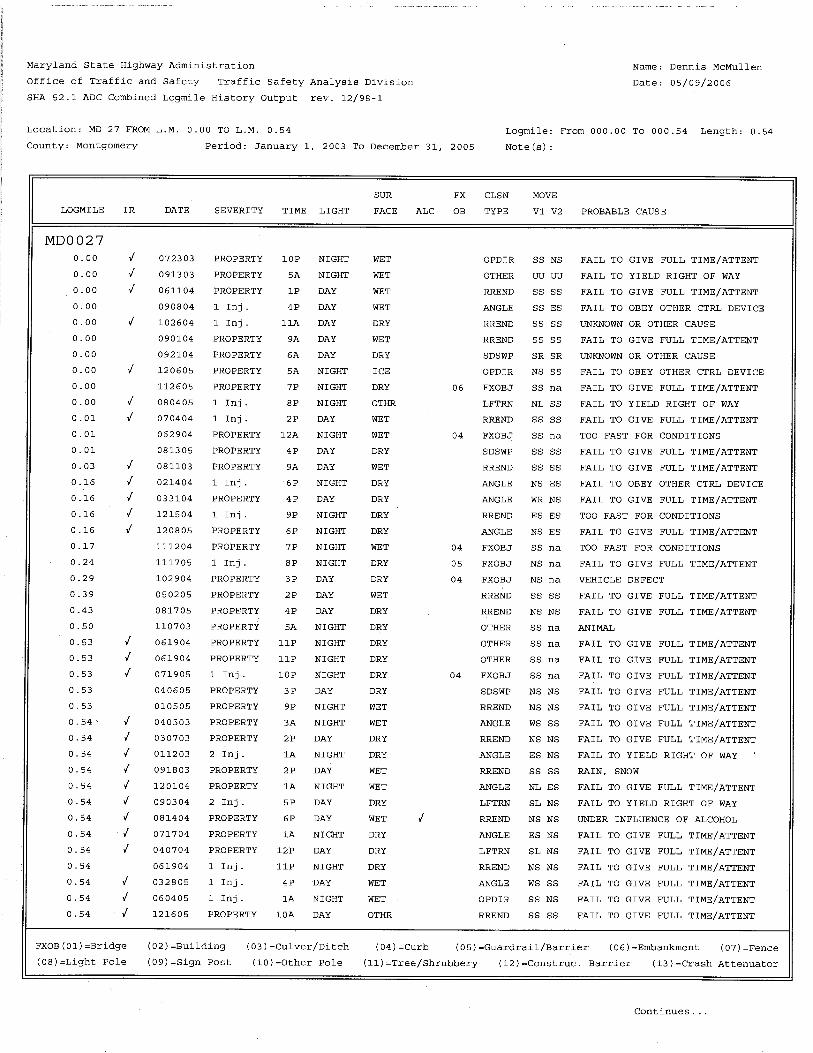


1
Montgomery County Department of Transportation
Response to the City of Gaithersburg Letter, Dated July 17, 2013 February 4, 2014
Comments on the Purpose and Need 1. Reduce existing and future congestion.
The document discusses the congestion on I-270 as a detriment to future economic growth; however, no data is provided to show how the various alternatives will impact I-270. While analysis of the alternatives is shown regarding congestion reductions on MD 355, the City would recommend that as part of any final environmental impact study (FEIS) modeling be restudied using current data. Based upon recent traffic counts initiated by the City, it appears that east/west traffic has been reduced significantly since 2011: Much of the data used in the MCS may no longer be accurate or reflect changing dynamics. Further, the study states MWCOG Regional Forecast Round 8.0 was used in the modeling. It is to be noted the current round is 8.2 with 8.3 to begin Fall 2013 and 9.0, Fall 2014. Lastly, the City supports the inclusion of a rapid transit vehicle (RTV) system as proposed in the County Executive’s “Transit Task Force Report” and how such a system impacts the need for any expansion of M-83, Midcounty Highway as part of this study. While it is stated that the potential RTV system was not included because it is not funded or in the CLRP, continued references to an unplanned/unfunded possible connection to the ICC are made as a benefit to specific alternatives. This is not consistent.
Response: The focus of the MCS was placed on improving local roadways within the study area because of the existing shortcomings that are being experienced on the local roadways such as congestion, travel delays, high accident rates, inferior pedestrian/bicycle facilities and lack of mobility. While MCDOT recognizes the congestion on I-270 as another transportation concern, I-270 is a major state facility that is being studied separately by SHA.
The travel demand models that are used for developing traffic volume projections for facility planning studies are constantly being updated by MWCOG. MCDOT has monitored changes in the MWCOG model throughout the facility planning study process and has incorporated the updated model results into the study when deemed appropriate based on the magnitude of the changes. For example, when RK&K updated the analysis being used for the current study back in 2011, major changes in the planned land use in and around the study area had been proposed as part of the update to the Germantown Master Plan. As a result, RK&K incorporated the updated model results. We feel this model has provided an accurate estimate of future traffic growth and has enabled our team to develop an accurate analysis of future traffic operations for each of the alternatives. MCDOT will continue to monitor changes to the model and a decision will be made at the appropriate time whether observed changes warrant further updates. Lastly, the references to a more direct connection to the ICC reference the fact that Alternative 9 will provide a complete partially access controlled arterial from Clarksburg to the ICC via Shady Grove Road which will improve access to the ICC with or without the missing segment of the “ICC Connector”. Also, the Transit Task Force report is an “aspirational” document that was never approved by the County Executive or County Council.

MCDOT’s Response to The City of Gaithersburg’s July 17, 2013 Letter February 4, 2014
2
2. Improve vehicular safety. The City questions the improvement to vehicular safety stated because the majority of conflict points, i.e. curb cuts on MD 355 remain regardless of alternative selected and further, as shown in the study, the City of Gaithersburg accident rates will be relatively unaffected regardless of alternative selected. Response: Alternative 5 would be expected to have some minor improvements to vehicular safety within the City due to the removal of driveway entrances and installation of service roads in select locations. Alternative 9 would also provide a safer alternative travel route compared to MD 355 because the roadway has access controls that limit access to local roadway intersections. This partial access controlled roadway will benefit all users of the roadway whether they reside in Gaithersburg, Germantown, Clarksburg or other outlying areas. One of the other benefits of Alternative 9 is that it reduces traffic volumes on MD 355 which we would anticipate to have the effect of reducing congestion and improving safety throughout the MD 355 corridor, thus benefiting residents and businesses in the City who use the road.
3. Enhance the efficiency of the roadway network and improve the connections between economic centers. The City has concerns regarding the claimed improvements to the roadway network. Some of the alternatives proposed may divert traffic to City streets not currently impacted. The economic centers discussed include the Life Sciences Center and businesses such as MedImmune-both well outside of the study area. Further, the City questions the proposed benefits of the “ladder configuration” discussed. It does not seem efficient that a driver would exit a congested I-270 to drive past MD 355 to join M-83, especially if the intended destination is anywhere but the Shady Grove Metro area. As to efficiency, the City notes that the travel time savings along MD 355 illustrated in Figure 3-12 at best equates to ±8 minutes northbound (Alternative 8) and ±10 minutes southbound (Alternative 9) during the peak hour; however, this savings is over an approximately 5 mile span and potentially unnoticeable by a driver not traversing the full 5 mile route. The City again questions the overall impacts of the alternatives for such a relatively small savings in drive time.
Response: The benefit of the ladder configuration that would be enhanced by providing another North/South route is that it gives people more options for accessing various destinations throughout the study area. If Alternative 9 is constructed, for instance, a person travelling north from Gaithersburg to Frederick (or vice versa) could use Midcounty Highway for a portion of the trip and then could access I-270 via Montgomery Village Avenue, Watkins Mill Road (with completion of the I-270 interchange), MD 118, Ridge Road, and/or Stringtown Road. Currently, that person would be forced to utilize Montgomery Village Avenue to access I-270 directly or to access via MD 355.
While the travel time numbers may not appear significant to some individuals, when you consider that these travel times affect tens of thousands of people each day, the cost savings in terms of productivity and quality of life issues are significant. Furthermore, travel time reduction is just one of several needs of the Mid-County Corridor Study project. Other benefits include travel safety, improved bicycle and pedestrian facilities, accommodation of planned growth, and mobility. Additionally, with the proposed improvements associated with Alternative 9, the opportunity will be created to provide access from Clarksburg to the I-95

MCDOT’s Response to The City of Gaithersburg’s July 17, 2013 Letter February 4, 2014
3
Corridor without using MD 355, I-270 or I-495. This improved access would be even further enhanced with the future construction of a direct connection from the southern end of Mid County Highway to the ICC. How each alternative satisfies the documented purpose and need and with what resultant impacts will be further documented in the PA/CM, and the Final EER will include a detailed discussion of the refined impact analysis and project outcome for the preferred alternative.
4. Accommodate planned land use and future growth.
For the City of Gaithersburg, many of the proposed alternatives conflict with City goals and Master Plan recommendations including not facilitating RTV on Frederick Avenue, losing passive open space, and potentially impacting current and future commercial properties and growth along Frederick Avenue. The study in fact states Alternative 5 would have the greatest potential for long-term indirect effects on businesses through changes in access attributable to the closure of existing entrances and the construction of service roads.
Response: We concur that some alternatives, such as Alternative 5, would impact properties along Frederick Avenue and would utilize right of way that could ultimately be utilized for the County’s planned BRT system on MD 355. On the other hand, Alternative 9 would have the effect of reducing traffic volumes on MD 355. Consequently, we feel Alternative 9 could significantly enhance the ability to repurpose 2 of the existing 6 lanes on MD 355 for BRT as is outlined in the recently approved Countywide Transit Corridors Functional Master Plan (CTCFMP).
5. Provide bicycle and pedestrian connections.
The City’s adopted 2009 Transportation Element identifies the deficiencies of the MD 355 bicycle/pedestrian facilities. The City believes none of the alternatives proposed address these issues. The bicycle/pedestrian facilities proposed would have little benefit to the City as it relates to MD 355 or connectivity for activity nodes within the City.
Response: As described in the Gaithersburg 2009 Transportation Master Plan Element, MD 355 has an existing shared use path and sidewalk within the City, north of Montgomery Village Avenue. Alternative 5 proposes to maintain the shared use path and sidewalk within the City limits. Along the alignment north of the City, Alternative 5 would construct continuous shared use path and sidewalks, enhancing pedestrian and bicycle connectivity to Gaithersburg.
6. Improve the quality of life.
The City has no comments regarding Homeland Security issues. As to improving quality of life, the study presented states this is accomplished through reduced commuting times and offering safer alternatives to congested local roads; however, as shown previously the City questions whether these claims are valid as it relates within our incorporated limits. While the quality of life may improve for Clarksburg and Germantown-at what cost to Gaithersburg? Response: We believe that offering alternative travel routes with improved travel times, safety, pedestrian/bicycle facilities, and mobility benefit the residents of all the study area

MCDOT’s Response to The City of Gaithersburg’s July 17, 2013 Letter February 4, 2014
4
corridor cities including Gaithersburg, Germantown and Clarksburg. In addition, the traffic volumes along portions of MD 355 and MD 124 within the city limits are projected to be lower under Alternative 4 Modified and Alternative 9, compared to Alternative 5, Alternative 8, and the No-Build Alternative. This reduction in traffic volumes under Alternatives 4 Modified and 9 will make it easier for city residents to access the residential and commercial areas along these roads without competing with as many drivers passing through from areas outside the city. These reductions in travel volumes on MD 355 should enhance the abilty of the County to carry out the newly adopted CTCFMP and repurpose existing travel lanes for the planned BRT line.
Comments Related to Alternatives Alternative 2: The City can support Alternative 2, TSM/TDM methods. This alternative is shown in the MCS to alleviate congestion and improve drive times with minimal investment utilizing the existing infrastructure and public rights-of-way, coupled with new express bus service. While this alternative is stated to not substantially improve vehicular traffic safety or mobility; would not provide a new highway or additional lane capacity; and would not provide additional bicycle and pedestrian connections as opposed to other alternatives, the City as discussed has questioned these claims regardless. This alternative would have the least impact to natural resources, parks, and property while still providing relief on MD 355 within the City.
Response: Comment acknowledged and noted. Alternative 5: The City would like to re-emphasize our opposition to this alternative. The City of Gaithersburg has long expressed its opposition to any alternative that directs traffic onto MD 355, Frederick Avenue. The proposed improvements, such as services roads and MD 355 widening, seem more “theoretical” rather than feasible. The MCS acknowledges such improvements will involve property acquisitions and land use impacts conflicting with zoning approvals previously granted by the City. The City further questions whether there is consensus from State Highway Administration (SHA) regarding these proposed changes. The City would like to review SHA’s position on this alternative and Alternative 8. Again as stated, this alternative does not address the inclusion of a RTV system as proposed in the County Executive’s “Transit Task Force Report” and currently being studied.
Response: Comment acknowledged. We note again that the Transit Task Force report was a recommendation to the Executive with no legal standing, and it was never endorsed by the Executive or Council. Alternative 8: This City also opposes this alternative in that it includes the fundamental issues related to the previous alternative discussed, plus the impacts to Blohm Park opposed in Alternative 9. In order for this alternative to work a number of improvements are needed that cannot be made without impacting existing properties located within the City. Further, the City is opposed to adding any M-83 “thru” traffic to the local streets. We continue to express concerns on the true impacts to the

MCDOT’s Response to The City of Gaithersburg’s July 17, 2013 Letter February 4, 2014
5
adjacent streets such as Russell Avenue and Christopher Avenue as well as the impacts to future redevelopment efforts in this vicinity. The study references M-83 as a northern Great Seneca Highway; however, it is the City’s opinion that this type of traffic should not be directed onto the City streets in this area. Response: Comment noted. Alternative 9: The City has long documented its concerns regarding the Master Plan Alignment and its impacts to the City’s Blohm Park. This alternative would fundamentally change if not effectively destroy the form and function of this park. The passive, scenic park would no longer exist. Response: Comment noted. MCDOT will continue to coordinate with City of Gaithersburg staff regarding mitigation needs for Blohm Park should the selected alternative impact the park. However, MCDOT would like to note that Blohm Park was designed and constructed well after the Master Plan Alignment was approved and adopted for the corridor, and the development of Blohm Park was completed with full disclosure of the long term planned right-of-way for the Midcounty Master Plan project. • Relocation of the gazebo structure. Response: As stated in MCDOT’s May 17, 2012 letter, the MCDOT is committed to working with the City to relocate the gazebo and associated trail access to a mutually agreeable location, as desired by the City, if either Alternative 8 or 9 is selected. • Construction of parking to offset the loss of on-street parking with Alternative 8 or
9. Response: Neither Alternative 8 nor Alternative 9 would result in the displacement of on-street parking at Blohm Park. Impacted on-street parking would be replaced in-kind as part of the proposed improvements for either alternative. • An exchange of County-owned parkland adjoining the City’s corporate limits to
replace impacted park acreage. Response: MCDOT is committed to working with the City and MNCPPC to identify an equitable exchange of land or fair compensation to mitigate the impacts to Blohm Park. • Participation in constructing a repurposing of the park as an “active” amenity
which could include design/build of a new skate park or similar type use. Response: With the exception of the area currently occupied by the gazebo and the circular trail leading to the gazebo, Blohm Park primarily consists of wetlands and floodplain.

MCDOT’s Response to The City of Gaithersburg’s July 17, 2013 Letter February 4, 2014
6
Repurposing the park for different uses is an action that should be undertaken solely by the City. Should the City move forward with this plan, MCDOT would be willing to work with the City to ensure safe and effective access could be provided from Watkins Mill Road.