appendix 9 – costar industrial land
TRANSCRIPT

Tonbridge & Malling Borough Council Local Plan Viability Study, including CIL – July 2018
259
Appendix 9 – CoStar Industrial Land The pages in this appendix are not numbered.

Tonbridge & Malling Borough Council Local Plan Viability Study, including CIL – July 2018
260

6Sale Price
Parcel Size
Price per Acre
Days on Market
Sale Price to Asking Price Ratio 40.00%
£55,000
0.36 AC
£23,529
243
£1,204,167
3.18 AC
£358,580
756
62.78%
£725,000
1.50 AC
£482,759
756
55.00%
£4,000,000
8.50 AC
£975,610
1,269
93.33%
5
5
2
3
Totals
Sold Transactions £7,225,000 Total Sales Transactions:Total Sales Volume: 6
Survey Criteria
basic criteria: Type of Property - Land; Sale Status - Under Offer, Sold; Return and Search on Portfolio Salesas Individual Properties - Yes
geography criteria: Submarket - Tonbridge & Malling (Kent)
Comps Statistics
CountHighMedianAverageLow
Quick Stats Report
Copyrighted report licensed to HDH Planning & Development Ltd - 701359. 23/02/2018
Page 1

1 1.45 acres open storage land at - London Rd SOLD
Sevenoaks, TN15 6AR
Sale Date:
Parcel No:
£/AC Land Gross:Sale Price:
£482,758.62 (£11.08/SF)£700,000 - Confirmed25/08/2016 (1,269 days on mkt) Land Area:
Lot Dimensions:Proposed Use:
Confirmed
1.45 AC (63,162 SF)--
Kent County
Research Status:Sale Conditions: -Comp ID: 3687297
2 Land - London Rd SOLD
Sevenoaks, TN15 7RL
Sale Date:
Parcel No:
£/AC Land Gross:Sale Price:
£23,529.41 (£0.54/SF)£200,000 - Confirmed24/04/2012 Land Area:
Lot Dimensions:Proposed Use:
Confirmed
8.50 AC (370,260 SF)--
Kent County
Research Status:Sale Conditions: -Comp ID: 2431319
3 Former Bridgewood Service Station - 467 Maidstone Rd SOLD
Chatham, ME5 9RX
Sale Date:
Parcel No:
£/AC Land Gross:Sale Price:
£152,773.92 (£3.51/SF)£55,000 - Confirmed30/10/2012 (243 days on mkt) Land Area:
Lot Dimensions:Proposed Use:
Confirmed
0.36 AC (15,682 SF)-Commercial
Kent County
Research Status:Sale Conditions: Auction SaleComp ID: 2698725
4 Development Site - New Hythe Ln SOLD
Aylesford, ME20 7TW
Sale Date:
Parcel No:
£/AC Land Gross:Sale Price:
£500,000.00 (£11.48/SF)£750,000 - Confirmed01/05/2014 Land Area:
Lot Dimensions:Proposed Use:
Confirmed
1.50 AC (65,340 SF)--
Kent County
Research Status:Sale Conditions: -Comp ID: 3066548
5 543 New Hythe Ln SOLD
Aylesford, ME20 7PE
Sale Date:
Parcel No:
£/AC Land Gross:Sale Price:
-£1,520,000 - Confirmed01/03/2010 Land Area:
Lot Dimensions:Proposed Use:
Confirmed
---
Kent County
Research Status:Sale Conditions: -Comp ID: 2416206
6 Vale Rise - Vale Rd SOLD
Tonbridge, TN9 1AA
Sale Date:
Parcel No:
£/AC Land Gross:Sale Price:
£975,609.76 (£22.40/SF)£4,000,000 - Confirmed31/12/2011 Land Area:
Lot Dimensions:Proposed Use:
Confirmed
4.10 AC (178,596 SF)Irregular-
Kent County
Research Status:Sale Conditions: -Comp ID: 2451610
Copyrighted report licensed to HDH Planning & Development Ltd - 701359. 23/02/2018
Page 2

Tonbridge & Malling Borough Council Local Plan Viability Study, including CIL – July 2018
261
Appendix 10 – Land Registry Development Land Data
Planning reference number
Site address Site Area Units Aff units TOTAL s106
Purpose of obligation Trigger points for compliance Status of development Details of on-site provision
Date payment received
Amount received after indexation
LR Title number Date Total Price Paid Price Paid /ha rice Paid / Unit
15/02817/FL (245) The Old Power Station, The Slade, Tonbridge
0.12 13 0 £33,573 POS - To be attributed upon receipt Education - Slade CP School
On or prior to commencement Not Commenced N/A K689206 6.03.2007 £625,000 £5,208,333 £48,077
15/02247/FL (241) Landfall, Teston Road, Offham 0.3 2 Off site AH provision within Borough Prior to commencement Under Construction N/A 3.08.2017 £10,000 K349711 29.03.2016 £700,000 £2,333,333 £350,000
15/01856/FL Franklin, East Street, Addington
0.31 3 Off site AH provision within Borough by a Registered Provider
Practical completion of final dwelling or 1st exchange of contracts whichever is earlier
Completed N/A 21 Mar 2017 £5,000 K582227 TT65685 14.12.2015 and 27.4.2017
£2,312,500 £7,459,677 £770,833
15/03172/FL (243) Former World of Pots Site, 15 Shipbourne Road, Tonbridge
0.38 38 £19,854 Off site AH provision within Borough and enhancement of existing open space in Tonbridge Area to be attributed on receipt
On or prior to first occupation Completed N/A 14.12.2017 £213,802 (AH); £19, 854 (POS)
15/01350/FL 2 Baltic Road, Tonbridge 0.077 6 £12,815 Off site provision in local area 10 working days after disposal of 4th unit
Completed N/A 09 Aug 2016 £12,817 Built out multiple owners
15/01914/FL 180 High Street, Tonbridge 0.07 12 0 £9,235 Provision and maintenance of open space in Tonbridge
On or before commencement Not Commenced N/A K963336 15.12.2009 £330,000 £4,714,286 £27,500
16/00505/FL (244) Area 63 Kings Hil l 1.41 44 0 £49,284 Improvement of West Malling Practice Group, Miverton Surgery or Wateringbury Surgery or other premises serving defined area
Prior to 1st occupation N/A
15/00704/FL 159 - 161 Pembury Road, Tonbridge
0.18 7 0 £28,367 Enhancement of existing open space in Tonbridge area
Prior to commencement Not Commenced N/A K725560 K651676 12.09.2017 £987,250 £5,484,722 £141,036
16/00799/FL 82 Goldsmid Road, Tonbridge 0.01 5 £9,542 Improvement of existing open space in locality
Prior to 1st occupation Under Construction N/A K314813 23.11.2015 £380,000 £38,000,000 £76,000
16/02327/FL (248) Area 2H Peters Vil lage 1.97 59 15 Affordable housing provision Occupation of the 59 units Not Commenced 15 units on site
N/A N/A K859495 and others
16/02920/FL (247) 14A Shipbourne Road, Tonbridge
0.03 5 £11,740 Not specified On or before commencement Under Construction N/A TT6797 1.08.2012 £125,000 £4,166,667 £25,000
16/02154/FL (246) Land at Plowenders Close, Addington
0.46 5 £18,755 To be attributed upon receipt (developer to be advised upon request, Clause 6.2)
Prior to 1st occupation Completed N/A 31 Jan 2017 £18,755 TT61049 61045 10.1.2017 £650,000 £1,413,043 £130,000
16/03657/FL New Hythe Lane/Sheldon Way, Larkfield
0.2 12 £20,520 Enhancement of St Brookfields Infants; Books at Larkfield Library
Prior to 1st occupation Not Commenced N/A TT59298 21.09.2017 £449,111 £2,245,555 £37,426
16/03534/FL The Harrow PH, Maidstone Road, Hadlow
0.31 6 £18,125 Improvement of existing open space in the locality
Prior to commencement Under Construction N/A K586736 26.08.2016 £615,000 £1,983,871 £102,500
16/03373/FL 133 High Street, Tonbridge 0.08 14 £42,268 To be attributed upon receipt Prior to 1st occupation Not Commenced N/A K300656 16.12.2016 £1,093,321 £13,666,513 £78,094
16/03380/FL Brunswick Yard, Pound Road, East Peckham
0.47 10 £41,126 To be attributed upon receipt but broken down as follows: Parks & gardens: 12,364; Outdoor OS: £22,683; Childrens play: £2,978; Natural spaces: £3,101
Prior to 1st occupation Not Commenced N/A k242922 no date
16/03025/OAEA Aylesford Newsprint, Bell ingham Way, Larkfield
17/01287/FL 2 - 4 High Street, West Malling
0.14 5 K437105 21.11.2008 £750,000 £5,357,143 £150,000
17/02635/FL Lyons Crescent, Tonbridge 0.13 14 K34039717/02248/FL Taddington Wood 0.61 517/00964/FL Phoenix House, Forstal Road,
Aylesford 0.28 12 3 K435055 22.1.2016 £425,000 £1,517,857 £35,417

Tonbridge & Malling Borough Council Local Plan Viability Study, including CIL – July 2018
262

Tonbridge & Malling Borough Council Local Plan Viability Study, including CIL – July 2018
263
Appendix 11 – SLAA Sites - Draft Allocations
Site Ref Site Name Ward Eastings Northings Type of Site Yield 19/20 20/21 21/22 22/23 23/24 24/25 25/26 26/27 27/28 28/29 29/30 30/31 Up to 2031 Post 2031
a Bushey Wood Phase 1, Eccles Aylesford North and Walderslade 572712 160517 Greenfield 900 75 150 150 150 150 125 100 900 0
Bushey Wood Phase 2, Eccles Aylesford North and Walderslade 572189 160177 Greenfield 614 614
b Rear of Robin Hood Lane, Blue Bell Hill Aylesford North and Walderslade 575186 162485 Greenfield 26 26 26 0
c 109 Hall Road, Aylesford Aylesford South Brownfield 5 5 5 0
d Oil Depot, Station Road, Aylesford Aylesford South Brownfield 14 14 14 0
e Nu-Venture Coaches, Mill Hall, Aylesford Aylesford South Brownfield 8 8 8 0
f Land off Oakapple Lane, Barming Aylesford South 572483 155445 Greenfield 118 40 78 118 0
g South Aylesford (east of Hermitage Lane) Aylesford South 572083 156893 Greenfield 1,000 75 150 150 150 150 150 150 25 1,000 0
h Borough Green Gardens Phase 1A + 1B Borough Green and Long Mill 560667 157811 Mixed 2,100 40 160 240 320 320 320 320 1,720 380
Borough Green Gardens Phase 1C Borough Green and Long Mill 562594 158035 Mixed 900 0 900
i Southways, Staleys Road, Borough Green Borough Green and Long Mill Ward 560525 157176 Brownfield 7 7 7 0
j Bell Lane, Burham Burham and Wouldham 572869 161771 Greenfield 26 26 26 0
k Land off Cobdown Close, Ditton Ditton 571047 158754 Greenfield 9 9 9 0
l Station Road, Ditton Ditton 571538 158625 Greenfield 6 6 6 0
m North of London Road, Ditton Ditton 571166 158455 Greenfield 13 13 13 0
n East Malling Research Station (Small Parcel) Ditton 570737 157826 Brownfield 23 23 23 0
o East Malling Research Station (Ditton edge) Ditton 571015 157719 Greenfield 216 40 80 80 16 216 0
p East Malling Research Station (Parkside) Ditton 570175 157530 Greenfield 205 40 80 80 5 205 0
q Barfield House, Teston Rd, Offham Downs and Mereworth 565231 157621 Mixed 15 15 15 0
r Park House, 110-112 Mill Street, East Malling East Malling Brownfield 5 5 5 0
s Court Lane Nurseries, Hadlow Hadlow and East Peckham 563708 149660 Mixed 66 40 26 66 0
t South of Church Lane, East Peckham Hadlow and East Peckham 567076 149155 Greenfield 35 35 35 0
u Carpenters Lane, Hadlow Hadlow and East Peckham 562938 150362 Greenfield 25 25 25 0
v Church Lane, East Peckham Hadlow and East Peckham 567173 149157 Greenfield 23 23 23 0
w North of The Paddock, Hadlow Hadlow and East Peckham 563119 150528 Greenfield 156 40 80 36 156 0
x Land at Stocks Green Road, Hildenborough Hildenborough 556827 148073 Greenfield 105 40 65 105 0
y Kings Hill - remainder Kings Hill Greenfield 65 40 25 65 0
z North of Kings Hill Kings Hill/ East Malling 568458 156080 Greenfield 900 25 100 100 100 100 100 100 100 100 825 75
aa Adjacent Larkfield Library Larkfield South 570172 158454 Brownfield 9 9 9 0
bb Tonbridge Farm Tonbridge - Castle 558736 148181 Mixed 54 40 14 54 0
cc North of Dryhill Park Road, Tonbridge Tonbridge - Castle 558761 147584 Greenfield 44 44 44 0
dd South West Tonbridge Tonbridge - Judd 557554 145577 Greenfield 480 40 80 80 80 80 80 40 480 0
ee South of Vauxhall Gardens, Tonbridge Tonbridge - Medway 559438 144982 Greenfield 61 40 21 61 0
ff Coblands Nursery, Trench Road, Tonbridge Tonbridge - Trench 558712 148597 Brownfield 352 40 80 80 80 72 352 0
gg Drayton Road Industrial Estate, Tonbridge Tonbridge - Vauxhall 559187 145540 Brownfield 51 40 11 51 0
hh East of Offham Road, West Malling West Malling and Leybourne 567562 157512 Greenfield 12 12 12 0
ii Rear of London Road and Town Hill, West Malling West Malling and Leybourne 567911 158182 Greenfield 110 40 70 110 0
jj Land at Howlands Allotments, Wrotham Wrotham, Ightham and Stansted 560792 159607 Greenfield 39 39 39 0
Totals 8,796 71 674 590 429 431 551 712 720 800 760 570 520 6,828 1,968
Tonbridge & Malling Borough Council Local Plan Viability Study, including CIL – July 2018
264
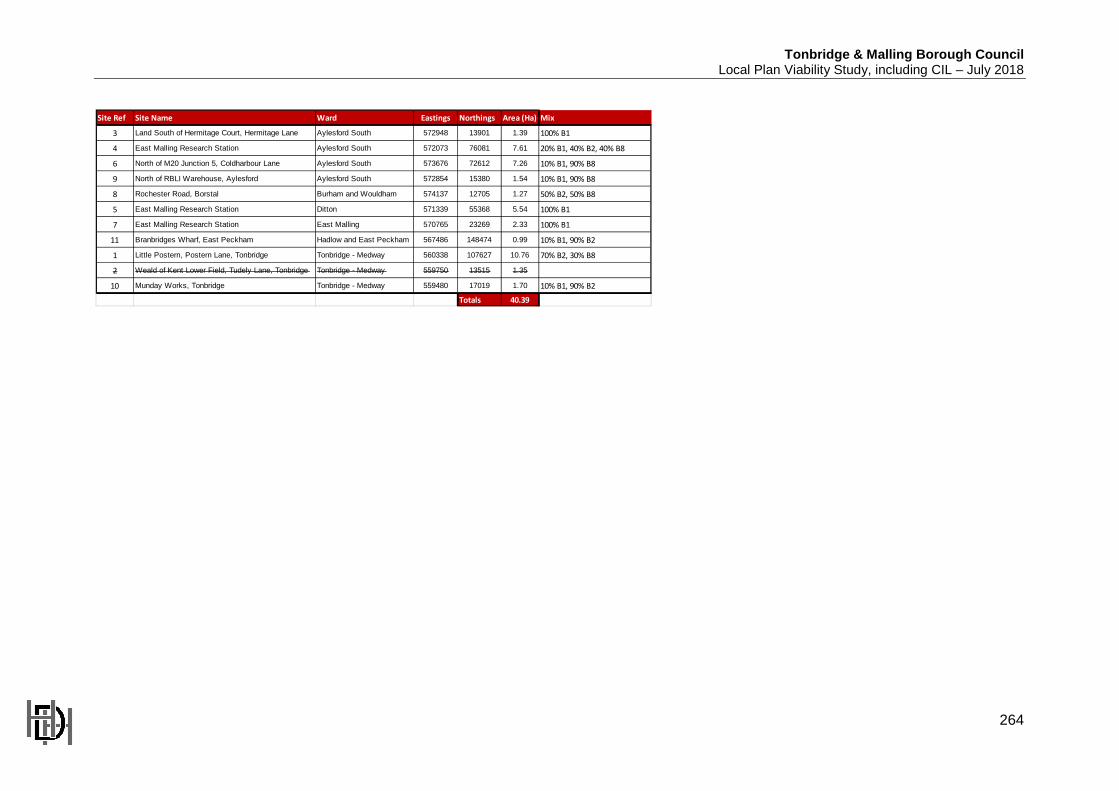
Site Ref Site Name Ward Eastings Northings Area (Ha) Mix
3 Land South of Hermitage Court, Hermitage Lane Aylesford South 572948 13901 1.39 100% B1
4 East Malling Research Station Aylesford South 572073 76081 7.61 20% B1, 40% B2, 40% B8
6 North of M20 Junction 5, Coldharbour Lane Aylesford South 573676 72612 7.26 10% B1, 90% B8
9 North of RBLI Warehouse, Aylesford Aylesford South 572854 15380 1.54 10% B1, 90% B8
8 Rochester Road, Borstal Burham and Wouldham 574137 12705 1.27 50% B2, 50% B8
5 East Malling Research Station Ditton 571339 55368 5.54 100% B1
7 East Malling Research Station East Malling 570765 23269 2.33 100% B1
11 Branbridges Wharf, East Peckham Hadlow and East Peckham 567486 148474 0.99 10% B1, 90% B2
1 Little Postern, Postern Lane, Tonbridge Tonbridge - Medway 560338 107627 10.76 70% B2, 30% B8
2 Weald of Kent Lower Field, Tudely Lane, Tonbridge Tonbridge - Medway 559750 13515 1.35
10 Munday Works, Tonbridge Tonbridge - Medway 559480 17019 1.70 10% B1, 90% B2
Totals 40.39