appendix 4.2: rdm tools and procedures - wrc home hub items... · 1 appendix 4.2: rdm tools and...
TRANSCRIPT

1
Appendix 4.2: RDM tools and procedures
The various tools, procedures, guidelines, training manuals and other aids that have been
developed to support RDM in South Africa are simply too numerous to list here. There are
also numerous methods that have been developed for other uses, some of which have been
used in RDM studies, but are either not approved by DWA or have proved too difficult to
apply in an RDM context, i.e. working fast with a small budget. The methods and tools that
are regularly applied to undertake activities required for the Preliminary Reserve Generic
Process are listed in Table 4-11 toTable 4-15, as follows:
Support in study initiation and design (Table 4-11)
Models and guidelines for the assessment of ecological condition (Table 4-12)
Reserve assessment methods (Table 4-13)
Models and tools to assist with input to the water quality component of the Ecological
Reserve (Table 4-14)
Socio-economic assessment methods (Table 4-15).

2
Tale 4-11 RDM assessment tools and procedures: Support in study initiation and design
Area addressed Procedure or tool Reference Phase in which development occurred
Description, level of use, status
Assessment level DSS
A DSS designed to assist RDM staff with deciding on the appropriate level of Reserve assessment.
(Louw and Hughes 2002)
Phase 2
Based on criteria such as time and budget constraints, the suitability of existing information and the potential for collecting required information. The level of appropriate assessment is linked to the availability of existing information, and the time allocated to the assessment. If insufficient information is available to relate ecological functioning to the hydrological regime through channel hydraulics and geomorphology, then the confidence in the outcome of a determination will be to low no matter how much effort is put into the study. This potentially valuable DSS is infrequent used by CD:RDM for reasons that are not clear.
(Ecological) Resource Unit delineation
Guidelines for delineating sub-basins, reaches or zones of an ecosystem (e.g. river reaches
1;
hydro-geomorphic wetland types) that are relatively homogenous in terms of morphological, biotic and anthropogenic conditions.
Louw (Kleynhans and Louw 2008; rivers); DWAF (2005 and 2008; wetlands)
Phase 2, although they incorporate information and procedures that were already available in Phase 1, such as ecoregions and site selection.
The approaches used for delineating rivers and wetlands are similar, and usually involve a hierarchical analysis of hydrological, geomorphological and physico-chemical characteristics; biotic communities; and anthropogenic alterations, such as those related to dams or points of significant water quality (e.g. effluent) or quantity (e.g., interbasin transfers) discharges. The aim being to identify a set of representative sites for more detailed study, which will allow the results to be scaled up to represent a larger area. This approach is widely used in Reserve assessments and underpins the delineation tasks in the WRCS.
1 For the purpose of this document, “reach” is broadly defined as “The reach is a length of channel characterised by a particular channel pattern and channel morphology, resulting
from a uniform set of local constraints on channel form (Rountree and Wadeson, 1999). Hundreds of metres to a few kilometres long.”
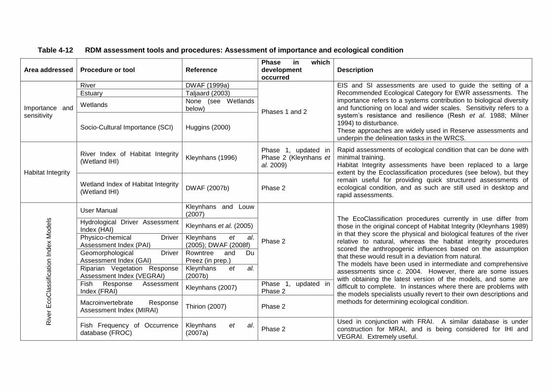
Table 4-12 RDM assessment tools and procedures: Assessment of importance and ecological condition
Area addressed Procedure or tool Reference Phase in which development occurred
Description
Importance and sensitivity
River DWAF (1999a)
Phases 1 and 2
EIS and SI assessments are used to guide the setting of a Recommended Ecological Category for EWR assessments. The importance refers to a systems contribution to biological diversity and functioning on local and wider scales. Sensitivity refers to a system’s resistance and resilience (Resh et al. 1988; Milner 1994) to disturbance. These approaches are widely used in Reserve assessments and underpin the delineation tasks in the WRCS.
Estuary Taljaard (2003)
Wetlands None (see Wetlands below)
Socio-Cultural Importance (SCI) Huggins (2000)
Habitat Integrity
River Index of Habitat Integrity (Wetland IHI)
Kleynhans (1996) Phase 1, updated in Phase 2 (Kleynhans et al. 2009)
Rapid assessments of ecological condition that can be done with minimal training. Habitat Integrity assessments have been replaced to a large extent by the Ecoclassification procedures (see below), but they remain useful for providing quick structured assessments of ecological condition, and as such are still used in desktop and rapid assessments.
Wetland Index of Habitat Integrity (Wetland IHI)
DWAF (2007b) Phase 2
Riv
er
EcoC
lassific
ation I
nd
ex M
od
els
User Manual Kleynhans and Louw (2007)
Phase 2
The EcoClassification procedures currently in use differ from those in the original concept of Habitat Integrity (Kleynhans 1989) in that they score the physical and biological features of the river relative to natural, whereas the habitat integrity procedures scored the anthropogenic influences based on the assumption that these would result in a deviation from natural. The models have been used in intermediate and comprehensive assessments since c. 2004. However, there are some issues with obtaining the latest version of the models, and some are difficult to complete. In instances where there are problems with the models specialists usually revert to their own descriptions and methods for determining ecological condition.
Hydrological Driver Assessment Index (HAI)
Kleynhans et al. (2005)
Physico-chemical Driver Assessment Index (PAI)
Kleynhans et al. (2005); DWAF (2008f)
Geomorphological Driver Assessment Index (GAI)
Rowntree and Du Preez (in prep.)
Riparian Vegetation Response Assessment Index (VEGRAI)
Kleynhans et al. (2007b)
Fish Response Assessment Index (FRAI)
Kleynhans (2007) Phase 1, updated in Phase 2
Macroinvertebrate Response Assessment Index (MIRAI)
Thirion (2007) Phase 2
Fish Frequency of Occurrence database (FROC)
Kleynhans et al. (2007a)
Phase 2 Used in conjunction with FRAI. A similar database is under construction for MRAI, and is being considered for IHI and VEGRAI. Extremely useful.

Area addressed Procedure or tool Reference Phase in which development occurred
Description
Estuary Estuarine Health Index Adams et al. (2002)
The specialists assess the extent to which changes in the flow regime have affected the frequency and duration of mouth closures, which is then used to assess the biological response. The approach is used in all estuarine Reserve assessments.
Wetlands PES and EIS assessment for wetlands
None. Phase 3
Modification of the Habitat Integrity assessment, which is applied at a quaternary catchment scale. Has been recently applied in for wetlands in the Outeniqua, Mkomati, Mokolo and Upper Vaal basins. Awaiting DWA approval.

Table 4-13 Environmental Water Requirement assessment methods
Name Description Reference Manual available?
RDM level(s) used at. Comment
Rivers
BBM JMK King et al (1998). Updated (King et al. 2008).
Yes. King et al. (2008)
Previously Intermediate; Comprehensive. Desktop and Rapid
The BBM principles form the basis of the Desktop Reserve Model estimates.
Desktop Model
Uses the relationship between the outcome of previous Reserve assessments and hydrology to predict Reserves for new systems. The percentage MAR recommended varies depending on the hydrological nature of the target river. This is captured in the Hydrological Index CVB, where strongly perennial systems have a low index value and ephemeral rivers a high index value. For example, the data set for
Error! Reference source not found. comprises
the results of past comprehensive EF studies and only includes rivers with index values up to 9.0, while most studies were done in rivers with indices in the region of 1.8 to 6.0. Thus the estimates for rivers with higher index values have a low confidence.
Hughes and Hannart (1999). Updated (Hughes and Munster 2003).
No. Desktop; Rapid I, II and III.
Widely used in desktop and rapid RDM studies. The IFR Edit Module is also used in the WRCS to extrapolated data from detailed study sites to other locations in the basin.
HFSR Method
Evaluates the change in habitat conditions for a range of lowflow conditions and the resulting ecological responses. Uses this stress index either set flows at different assurances and seasons for a range of ecological categories, or to evaluate flow scenarios to assess the resulting ecological categories.
After O’Keeffe et al. (2002)
Yes (IWR Source-to-Sea 2004)
Intermediate; comprehensive.
Widely used in RDM studies. The stress indices can also be used in rapid assessments and will form the basis of the revised Desktop. The manual is outdated as many new tools have been developed since it was compiled.
DRIFT Method
Uses response curves between flow indicators and a range of biophysical indicators to describe the implications of flow change relative to present day.
King et al. 2003. Yes. Brown et al. (2008)
Intermediate; comprehensive.
Widely used in RDM studies in the Western Cape. However most of its applications have been outside of South Africa.

Name Description Reference Manual available?
RDM level(s) used at. Comment
Wetlands
Rapid Reserve Determination methods for Wetlands
Uses a similar approach to BBM to define lowflow and flood requirements for wetlands.
Rountree (2010) Yes. Rountree (2010).
Rapid
Has been tested across a range of wetlands types but has not yet been widely applied.
Hydrological approach to determine pan inundation
An hydrological approach using rainfall-inundation correlations for determining the patterns of pan inundation.
Fluvius (2007) No. Rapid
Very low confidence assessment used to identify the historic patterns of pan inundation to guide management and set RQO’s. Basic biotic information was used to guide the EWR requirements.
Estuaries
RDM method for estuaries
RDM method for estuaries DWAF (1999b)
Yes. DWAF (1999b).
Rapid, Intermediate and Comprehensive
Used for every estuarine Reserve assessment in the country. Updated and adjusted as required in discussion with estuarine environmental flow specialists.
Update of RDM method for estuaries based on lessons learnt
DWAF (2004b)
Desktop assessment DWA (2009) No. Desktop
Recently developed through application for the Gwaing Estuary. Will require additional applications and revision before being accepted for wider use.
Groundwater
Herold Method
Use to calculate groundwater contribution of the baseflow and surface runoff. Comprises a model that computes monthly basis diffuse salt loads associated with runoff.
Herold (1980) Yes (Herold 1980).
Desktop, Rapid Widely used in RDM studies to determine the groundwater component of the Reserve.

Name Description Reference Manual available?
RDM level(s) used at. Comment
Sami Model Use to calculate groundwater contribution of the baseflow and surface runoff.
DWAF (2006) Yes (DWAF 2006)
Rapid, Intermediate and Comprehensive
Ongoing discussion about which, if any of these, model is most suitable for determining the groundwater contributions to Reserve baseflows.
Groundwater Resource Directed Measures (GRDM) Method
Alternate methods for determination of the Groundwater Reserve, which are currently being compared and evaluated.
IGS (2006) Yes (IGS 2006).
Rapid, Intermediate and Comprehensive
Groundwater Yield Model for the Reserve (GRYM) Method
DWA (2010) No. Rapid, Intermediate and Comprehensive
Figure 4-3 Maintenance total IFR requirements for A, B, C and D category rivers. The heavy lines are the total flow requirements, while the broken lines represent the low flow requirements. The high flow requirements are the differences between the two sets of lines.

Table 4-14 Models and tools to assist with input to the water quality component of the Ecological Reserve
Name Description Reference Used for: Comment
A draft manual for the determination of the water quality component of the Ecological Reserve, which consolidates several different approaches, was produced in Phase 2 (DWAF 2002; DWAF 2008f). However, the paucity of appropriate water quality modeling methods, or a systems model for water quality for RDM requirements, is a critical gap in the current method.
TEACHA Analytical tool. This is currently the only tool available for the production of aggregated salts from chemical data.
DWAF (2004c; 2008f) – includes TEACHA notes and model information as prepared by Jooste S, DWAF: RQS.
Physico-chemical data analysis and production of ratings to be used in the PAI model.
Further development is needed as data input problems are regularly experienced. This tool is of particular value in desktop assessments.
PAI model Model used to generate a PES of the water quality component of the Ecological Reserve.
Kleynhans et al. (2005); DWAF (2008c).
Generation of the integrated water quality present state category for the Ecological Reserve.
See Error! Reference source not found..
Resource Water Quality Objectives (RWQO) Model
Model to be used by DWAF RO / practitioners to determine the most sensitive user for which RQO will be prescribed.
-
To determine the most sensitive user according to which RWQOs will be prescribed. Quality Ecospecs from the Reserve process form the ecological input data.
Version 5.0 released in 2009. Some DWAF staff members have been trained in the use of the model but it has not yet been widely used.
Flow-concentration Model
Simple flow-concentration modeling using parameters with strong flow-concentration relationships, e.g. salts.
Malan and Day (2002), Malan et al. (2003), Malan (2004).
Integration of quality and quantity and to provide water quality consequences of a range of predicted flow scenarios.
The model is of limited use for non-conservative variables such as nutrients (i.e. those variables that undergo biological and chemical conversion, and their concentration is altered by factors other than water volume e.g. bacterial degradation).
Water Resources Planning Model (WRPM)
The WRPM can be used to simulate water quality scenarios for Total Dissolved Solids (TDS) (i.e. salinity) under different management and flow scenarios.
Trevor Coleman modeled this for the Vaal system (DWAF 2008g).
Simulates TDS concentrations under various management and flow scenarios.
The use of this tool is restricted to TDS – a similar approach is needed for other variables, particularly nutrients.

Table 4-15 Socio-economic RDM tools
Name Description Reference Used for: Comment
Basic Human Needs Determination Approach
Word document outlining suggested approach to determining quantity of water required for satisfaction of the Basic Human needs component of the reserve
Huggins (2008). Draft submitted to Department of Water Affairs for comment.
Determination of Basic Human Needs
Method proposed in the model is applicable to all catchments in the RSA.
Socio- Cultural Importance
Spreadsheet with model for determining the importance of quaternary catchments with respect to socio-cultural importance
- Determination of Socio Cultural Importance at level of quaternary catchment.
Spreadsheet needs some expert input as weighting varies with nature of the catchment/resource being studied
Framework and Manual for the evaluation of aquatic ecosystems services for the Resource Directed Measures
A four-part methodology which is consonant with RDM procedures, incorporates the Millennium Ecosystm Assessment framework and makes use of best international standards of resource economics
Ginsberg et al. (2009). Evaluation of aquatic ecosystems services.
The method has been applied to the Crocodile and Marico Basins, and is planned for application in the Mzimkulu Basin.

Appendix 4.3: Reserve template
PRELIMINARY DETERMINATION OF THE RESERVE AND RESOURCE CLASS IN TERMS OF SECTION 14(1)(b) AND 17 (1) OF THE NATIONAL WATER ACT, 1998 (ACT NO. 36 OF
1998)
I, HARRISON HURSINEY PIENAAR, in my capacity as Chief Director: Resource Directed Measures and duly authorised in terms of section 63 of the National Water Act, 1998 (Act No. 36 of 1998), do hereby declare the preliminary determination of the Reserve and preliminary resource class as contained below. _________________________________________________________ CHIEF DIRECTOR: RESOURCE DIRECTED MEASURES DATE: 1 Description of the Surface Water Resource. River : Dwars River Drainage Region: B41H (at EWR site, S24° 50’ 38.1”; E30° 05’ 30.8”) Water Management Area: Olifants 2 Preliminary determination of the Reserve for Water QUANTITY for
surface and groundwater in terms of section 17(1)(a)
Surface water: 27.6% of the Mean Annual Runoff of 31.4 million cubic metres.
Groundwater: 38% of the mean annual Recharge of 8.62 million cubic
metres.
NOTE: In respect to surface water, the amount accounts for both the ecological Reserve (25.9%) and the basic human needs Reserve (1.7%).
3 Preliminary determination of the Reserve for Water Quality in terms of
section 17(1) The Reserve (Ecological and Basic Human Needs) for water quality is determined on a preliminary basis and is defined by the minimum water quality specifications provided in Annexure B.
Note: Streamflow at each Ecological Water Requirement (EWR) site must at all times comply in all respects with the water quality specifications set for the particular site. 4 Preliminary determination of the resource class in terms of section
14(1)(b) Equivalent to the recommended ecological Reserve category of B/C. Category B/C represents a largely natural to moderately modified state.

5 Applicability 5.1 This preliminary determination of the Reserve in terms of section 17(1)(a) is
applicable to the following water resource or part of the resource: Dwars River, cumulative at the EWR site (S24° 50’ 38.1”; E30° 05’ 30.8”) in quaternary catchment B41H.
5.2.1 This preliminary determination of the Reserve in terms of section 17(1)(b) is
applicable to the authorising of following water uses:
Section 21(a) – taking water from a water resource.
Section 21(b) – storing of water.
Section 21(c) – impeding or diverting the flow of water in a watercourse.
Section 21(d) – engaging in a streamflow reduction activity.
Section 21(f) – discharging waste or water containing waste into a water resource through a pipe, canal, sewer, sea outfall or other conduit.
Section 21(g) – disposing of waste in a manner which may detrimentally impact on a water resource.
Section 21(i) – altering the bed, banks, course or characteristics of a watercourse.
Section 21(j) – removing, discharging or disposing of water found underground if it is necessary for the efficient continuation of an activity or for the safety of people.
Section 21(k) – using water for recreational purposes. 6 Additional supporting documentation is provided in the following
Annexures Annexure A: Preliminary Ecological Reserve – Water Quantity Annexure B: Preliminary Ecological Reserve – Water Quality Annexure C: Preliminary Groundwater Reserve – Water Quantity Annexure D: Basic Human Needs Reserve Annexure E: Resource Quality Objectives Annexure F: Background and Record of Decision Annexure G: Methodology Annexure H: Specialist Reports Annexure I: Map of Study Area

ANNEXURE A
PRELIMINARY ECOLOGICAL RESERVE:
WATER QUANTITY

RIVER ECOSYSTEMS COMPONENT – WATER QUANTITY 1. Level of confidence of the determination: Medium
2. The determination is applicable to the cumulative flow at the EWR site in quaternary catchment B41H. This means that the Ecological Water Requirements (EWR) are based on the natural flow contribution of the catchments upstream of B41H up to the EWR site at S24° 50’ 38.1”; E30° 05’ 30.8”.
3. Table 1 provides a summary of the flow characteristics and EWR requirements.
4. Table 2 provides a summary of EWR rule curves for the water quantity component of the ecological Reserve.
Table 1 Summary of EWR estimates at the EWR site (S24° 50’ 38.1”; E30° 05’
30.8”) in Quaternary Catchment: B41H
Desktop Version 2, Printed on 2008/04/21 Summary of EWR estimate for: Dwars_EWR1
Total runoff, cumulative at EWR Site 1 (S24° 50’ 38.1”; E30° 05’ 30.8”) in quaternary
catchment B41H
Annual Flows (Mill. cu. m or index values):
MAR = 31.429*
S.Dev. = 22.106
CV = 0.703
Q75 = 0.660 (Q75/MMF = 0.252)
BFI Index = 0.431
CV(JJA+JFM) Index = 1.747
REC = B/C**
Total IFR = 8.142 (25.91 %MAR)
Maint. Lowflow = 6.099 (19.41 %MAR)
Drought Lowflow = 2.289 ( 7.28 %MAR)
Maint. Highflow = 2.042 ( 6.50 %MAR)
Monthly Distributions (cu.m./s)
Distribution Type : Olifants
Month Natural Flows Modified Flows (IFR)
Low flows High Flows Total Flows
Mean SD CV Maint. Drought Maint. Maint.
Oct 0.337 0.418 0.463 0.107 0.043 0.060 0.167
Nov 1.149 1.464 0.492 0.160 0.061 0.060 0.220
Dec 1.841 1.754 0.356 0.215 0.080 0.144 0.359
Jan 1.977 2.007 0.379 0.251 0.092 0.141 0.392
Feb 2.230 2.964 0.550 0.310 0.113 0.293 0.603
Mar 1.576 2.140 0.507 0.280 0.102 0.094 0.374
Apr 1.049 0.902 0.332 0.264 0.097 0.000 0.264
May 0.659 0.530 0.300 0.215 0.080 0.000 0.215
Jun 0.420 0.244 0.224 0.173 0.066 0.000 0.173
Jul 0.305 0.137 0.168 0.134 0.052 0.000 0.134
Aug 0.257 0.131 0.190 0.114 0.045 0.000 0.114
Sep 0.242 0.122 0.195 0.107 0.043 0.000 0.107
* Virgin mean annual runoff (VMAR) based on the total flow from quaternary catchment B41G and 18% of B41H. Flow record scaled from the Steelpoort River flow record as determined during the high confidence Reserve determination study for the Olifants River.
** Recommended Ecological category determined during the intermediate Reserve determination study on the Dwars River at EWR site (S24° 50’ 38.1”; E30° 05’ 30.8”) in quaternary catchment B41H.

Table 2 Summary of EWR Rule Curves for the EWR site (S24° 50’ 38.1”; E30°
05’ 30.8”) in Quaternary Catchment: B41H Desktop Version 2, Printed on 2008/04/21 Summary of EWR rule curves for: Dwars_EWR1
Total runoff, cumulative at EWR site 1 (S24° 50’ 38.1”; E30° 05’ 30.8”) in
quaternary catchment B41H
Regional Type : Olifants
REC = B/C**
Data are given in m^3/s mean monthly flow % Points
Month 10% 20% 30% 40% 50% 60% 70% 80% 90% 99%
Oct 0.199 0.198 0.195 0.188 0.175 0.155 0.126 0.092 0.063 0.050
Nov 0.266 0.265 0.262 0.256 0.244 0.224 0.192 0.148 0.099 0.068
Dec 0.429 0.426 0.421 0.411 0.392 0.358 0.305 0.231 0.148 0.096
Jan 0.586 0.548 0.514 0.480 0.443 0.379 0.324 0.248 0.162 0.108
Feb 0.956 0.878 0.809 0.745 0.678 0.565 0.479 0.361 0.229 0.146
Mar 0.531 0.505 0.480 0.455 0.424 0.372 0.319 0.246 0.165 0.113
Apr 0.326 0.324 0.319 0.309 0.289 0.258 0.214 0.162 0.119 0.098
May 0.265 0.264 0.260 0.251 0.236 0.210 0.174 0.133 0.098 0.081
Jun 0.214 0.212 0.209 0.202 0.190 0.170 0.141 0.108 0.080 0.067
Jul 0.165 0.164 0.162 0.157 0.147 0.132 0.110 0.084 0.063 0.053
Aug 0.141 0.140 0.138 0.133 0.125 0.112 0.094 0.072 0.054 0.046
Sep 0.132 0.131 0.129 0.125 0.118 0.106 0.088 0.068 0.051 0.044
Reserve flows without High Flows
Oct 0.132 0.131 0.129 0.125 0.118 0.106 0.088 0.068 0.051 0.044
Nov 0.199 0.198 0.196 0.192 0.184 0.170 0.148 0.117 0.083 0.062
Dec 0.268 0.266 0.263 0.258 0.247 0.228 0.198 0.157 0.110 0.081
Jan 0.312 0.311 0.307 0.301 0.288 0.266 0.231 0.182 0.128 0.093
Feb 0.386 0.384 0.380 0.371 0.356 0.328 0.285 0.224 0.157 0.115
Mar 0.348 0.347 0.343 0.335 0.321 0.296 0.257 0.203 0.142 0.104
Apr 0.326 0.324 0.319 0.309 0.289 0.258 0.214 0.162 0.119 0.098
May 0.265 0.264 0.260 0.251 0.236 0.210 0.174 0.133 0.098 0.081
Jun 0.214 0.212 0.209 0.202 0.190 0.170 0.141 0.108 0.080 0.067
Jul 0.165 0.164 0.162 0.157 0.147 0.132 0.110 0.084 0.063 0.053
Aug 0.141 0.140 0.138 0.133 0.125 0.112 0.094 0.072 0.054 0.046
Sep 0.132 0.131 0.129 0.125 0.118 0.106 0.088 0.068 0.051 0.044
Natural Duration curves*
Oct 0.534 0.452 0.317 0.261 0.246 0.190 0.179 0.164 0.149 0.108
Nov 3.981 1.586 0.965 0.764 0.610 0.455 0.382 0.313 0.212 0.127
Dec 4.962 3.524 2.139 1.837 0.960 0.780 0.605 0.508 0.399 0.179
Jan 4.716 2.991 2.113 1.714 1.262 1.068 0.862 0.728 0.411 0.317
Feb 6.510 2.670 1.732 1.368 1.108 0.897 0.728 0.637 0.500 0.335
Mar 3.483 1.714 1.329 1.068 0.877 0.769 0.646 0.508 0.411 0.220
Apr 2.211 1.447 1.246 1.007 0.795 0.652 0.567 0.413 0.297 0.185
May 1.385 1.027 0.687 0.564 0.523 0.452 0.329 0.302 0.261 0.164
Jun 0.764 0.567 0.440 0.382 0.340 0.297 0.282 0.255 0.228 0.154
Jul 0.523 0.399 0.317 0.287 0.273 0.261 0.220 0.205 0.190 0.123
Aug 0.370 0.329 0.261 0.246 0.220 0.205 0.205 0.179 0.164 0.108
Sep 0.440 0.282 0.239 0.212 0.197 0.197 0.185 0.170 0.154 0.100
* Virgin mean annual runoff (VMAR) based on the total flow from quaternary catchment B41G and 18% of B41H. Flow record scaled from the Steelpoort River flow record as determined during the high confidence
Reserve determination study for the Olifants River.
** Recommended Ecological Reserve category determined during the intermediate Reserve determination study on the Dwars River at EWR site (S24° 50’ 38.1”; E30° 05’ 30.8”) in quaternary catchment B41H.
ANNEXURE B
PRELIMINARY ECOLOGICAL RESERVE:
WATER QUALITY

RIVER ECOSYSTEMS COMPONENT – WATER QUALITY
Table 1 Site information summary for the water quality component of
intermediate Dwars River Reserve
Reference
State Present state Comments
Station name B4H009Q01 B4H009Q01
To continue or institute bi-monthly monitoring at DWAF’s gauging weir, B4H009Q01
Full data period 1977–2007: 1058 samples
Total number of records used
1977-1981: n=95 (but 207 for EC)
2005-2007: n=62 (but 66 for TIN)
Trend significance Stable
Causes for concern would be spillage from slimes dams during “upset” conditions
Known point sources of pollution upstream
Irrigation runoff and mining activities
Elevated nutrient status and toxics
Other land-uses None
EISC (Ecological Importance and Sensitivity Category)
High
PESC (Present Ecological State Category) or EcoStatus
B/C
Recommended water quality category of the overall REC
B/C
Software or method used Data analysis using Excel and PAI model
Confidence Confidence in the assessment is moderate due to the small database of information available for temperature, oxygen, turbidity and toxics.
NOTE: This Reserve is recommended under the following constraints:-
Use of the best available scientific knowledge and method (software)
Based on available data

Table 2 Water quality specifications (Quality Ecospecs) for the
intermediate Reserve of the Dwars River
Quality Constituent
Parameter Ecological Reserve Requirements
Basic Human Needs Requirement5
Reserve Requirement: water quality
General
chemistry – major inorganic salts
MgSO4 (mg/l) 1 < 16 N/A < 16
Na2SO4 (mg/)l 1 < 20 N/A < 20
MgCl2 (mg/l) 1 < 15 N/A < 15
CaCl2 (mg/l) 1 < 21 N/A < 21
NaCl (mg/l) 1 < 45 N/A < 45
CaSO4 (mg/l) 1 < 351 N/A < 351
General chemistry – Major Ions
Sodium (mg/l) N/A <200 <200
Magnesium (mg/l) N/A <100 <100
Chloride (mg/l) N/A <200 <200
Calcium (mg/l) N/A <80 <80
Sulphate (mg/l) N/A <400 <400
Nutrients
Phosphate (PO4) (mg/l) 2 <0.021mg/L N/A <0.021mg/L
Total Inorganic Nitrogen (mgN/l)2
<4.0mg/L N/A <4.0mg/L
Physical water quality
pH (range) 5th percentile 95th percentile
6.5 8.8
5 9.5
6.5 8.8
Dissolved Oxygen (mg/l)1
>7 mg/L N/A >7 mg/L
Temperature1
Vary by no more than 2ºC from the natural range (samples to be taken at approximately the same time every day)
Vary by no more than 2ºC from the natural range
Electrical conductivity (mS/m) – USE ONLY IF AGGREGATED SALTS NOT AVAILABLE
≤55mS/m 0-70 ≤55mS/m
Biological
water quality
Chl-a: periphyton3 <63 mg/m2 N/A
Chl-a: phytoplankton3 < 10 µg/L (A category)
N/A
Biotic community composition - macroinveterbrates
ASPT: 6 (B/C category)
In-stream toxicity In-stream toxicity should not occur
Toxics and complex mixtures
Toxics (as listed in DWAF, 1996 6)
≤ TWQR ≤ TWQR ≤ TWQR

NOTES:
1 : 95th percentile compliance. 2: 50th percentile compliance 3 Chl-a is not applicable to Desktop Reserve studies 4 90th percentile compliance 5 ref: South African Water Quality Guidelines, Volume 1: Domestic Water Use, 2nd Ed. 1996. Department of Water Affairs and Forestry. Pretoria, South Africa. 6 ref: South African Water Quality Guidelines, Volume 7: Aquatic Ecosystems, 2nd Ed. 1996. Department of Water Affairs and Forestry. Pretoria, South Africa. Where a difference in the water quality values for the Ecological Reserve and Basic Human Needs Reserve was found, the stricter or more protective value was selected for the water quality component of the Reserve.

ANNEXURE C
PRELIMINARY GROUNDWATER RESERVE:
WATER QUANTITY

GROUNDWATER RESERVE DETERMINATION — QUANTITY
Quaternaries Area
(km2) Recharge1)
(Mm3/a)
Groundwater component of
baseflow2) (Mm3/a)
Baseflow for EWR (Mm3/a)
Reserve as % of Recharge
B41G & B41H 442 8.62 4.67 3.29 38
Notes
Recharge calculated as 3% of MAP of 650mm.
The baseflow for EWR is based on a Maintenance Low Flow (MLF) of 0.122 m3/s for a category B/C.
Definitions
Recharge: Water reaching the aquifer directly from precipitation and the infiltration of surface water. 1)
Baseflow:2 Baseflow is that part of stream flow that derives from groundwater and shallow subsurface storage. During the dry season, the stream flow is typically composed entirely of baseflow. 2)
Groundwater component of baseflow: This is the component of Baseflow that derives from the aquifer adjacent to a surface water body, and excludes interflow in the vadose zone or short–term storm events which saturate the subsurface soil and discharge to a surface water body before reaching the aquifer. The Herold Baseflow Separation Model is used. 2)
Baseflow required by EWR: The volume of baseflow required by the instream flow requirements set for the surface water component of the Reserve.
The Reserve constitutes the sum of the baseflow required by IFR plus the BHN reserve expressed as a percentage of the Recharge.
1) Bredenkamp, D.B., Botha L.J., van Tonder, G.J. and Van Rensburg, H.J. (1995). Manual
on quantitive estimation of groundwater recharge and aquifer storativity. WRC Report TT 73/95
2) Herold, C.E. (1980). A model to compute on a monthly basis diffuse salts associated with runoff. HRU report no 1/80.
2 This is the definition as provided in the official templates. The definition included in the Groundwater
Dictionary is as follows: "Sustained low flow in a river during dry or fair weather conditions, but not necessarily all contributed by groundwater; includes contributions from interflow and groundwater discharge."

ANNEXURE D
BASIC HUMAN NEEDS

BASIC HUMAN NEEDS RESERVE The basic human needs reserve provides for the essential needs of individuals served by the water resource in question and includes water for drinking, food preparation and for personal hygiene. A lifeline amount of 25 litres per person per day was used.
Quaternary
Population
(Current
requirement)
Per capita need
(Litres / day)
BHN Reserve required
MCM / annum % VMAR
B41H 58 478* 25 0.5336 1.7
* This figure includes the total population of quaternary catchment B41H
MCM: million cubic metres VMAR: virgin mean annual runoff The cumulative VMAR at the EWR site (S24° 50’ 38.1”; E30° 05’ 30.8”) in
quaternary drainage region B41H is 31.4 million cubic metres.

ANNEXURE F
BACKGROUND AND RECORD OF DECISION

BACKGROUND AND RECORD OF DECISION
Study Team Project management: DWAF: RDM B Weston Consultants R Stassen E van Niekerk P Scherman M Rountree M Graham B Niehaus P Kotze J Crafford A Jordonova
Compilation of Reserve determination report: JMM Stassen: R Stassen Motivation for Reserve Determination This preliminary determination of the Reserve was undertaken for quaternary catchments B41G and B41H in response to the construction of the proposed Richmond Dam and the associated license applications in the Dwars River catchment related to mining activities. Scope of Study A preliminary determination for both the surface (quantity and quality) and groundwater (quantity) component of the ecological Reserve as well as the basic human needs Reserve for the Dwars River in quaternary catchment B41H, using a medium confidence procedure, was undertaken. The Reserve determination study was undertaken at the EWR site (S24° 50’ 38.1”; E30° 05’ 30.8”) in quaternary catchment B41H.
ANNEXURE G
METHODOLOGY

METHODOLOGY USED Ecological Reserve The methodology used for the determination of the ecological Reserve (surface water) is that set out in DWAF (1999): Resource Directed Measures for Protection of Water Resources; Volume 3: River Ecosystems Version 1.0 The methodology used for the determination of the water quality component of the ecological Reserve is that set out in: DWAF (2002): Hazard-based water quality ecological specifications for the Ecological Reserve in fresh water Resources. Report No. N/0000/REQ0000. Institute for Water Quality Studies, Department of Water Affairs and Forestry. Author: Jooste S. DWAF (2008): Methods for determining the water quality component of the Ecological Reserve. Report prepared for Department of Water Affairs and Forestry, Pretoria, South Africa by P-A Scherman. Draft 2, March 2008. The methodology used for the determination of the groundwater component of the ecological reserve is that set out in DWAF (1999): Resource Directed Measures for Protection of Water Resources; Volume 6: Ground Water Component Version 2.0. Resource Category The methodology for preliminary determination of the water resource category is part of the methodology referenced in DWAF (1999): Resource Directed Measures for Protection of Water Resources; Volume 3: River Ecosystems Version 1.0. Basic Human Needs Reserve The quantity component of the basic human needs Reserve was calculated from population water requirements provided by Chief Directorate: Water Services, Directorate: Community Water Planning. The population figures used were based on the 1991 census and extensive field verification project initiated in 1994. The average population for quaternary catchment B41H was used. This component of the Reserve has been accounted for in the surface water quantity component of the Reserve. The water quality component of the basic human needs Reserve was determined using: Quality of Domestic Water Supplies, Volume 1: Assessment Guide, 2nd Ed. 1998. Water Research Commission Report No: TT101/98. Pretoria, South Africa, and South African Water Quality Guidelines, Volume 1: Domestic Water Use, 2nd Ed. 1996. Department of Water Affairs and Forestry, Pretoria, South
Africa

ANNEXURE H:
SPECIALIST REPORTS Stassen R, 2008. Intermediate ecological Reserve determination for the Dwars
River catchment (quaternary catchments B41G and B41H), tributary of the Steelpoort River, Mpumalanga. Report prepared for BKS (Pty) Ltd.
Hobbs P, 2005. Determination of the ecological water requirements for the Dwars
River in quaternary catchment B41G, groundwater component. Report prepared for BKS (Pty) Ltd

References for Chapter 4 Abban B., M. Shand, M. Makhabane, W. Kamish, T. Tente and B. van Zyl 2009. Decision Support
System for the Berg River Dam and Supplement Scheme. Proceedings of the
International Conference on the Implementation of Environmental Flows. Port
Elizabeth, 2009.
Adams J.B., G.C. Bate, T.D. Harrison, P. Huizinga, S. Taljaard, L. van Niekerk, E. Plumstead A.K.
Whitfield and T.H. Wooldridge 2002. A method to assess the freshwater inflow
requirements of estuaries and application to the Mtata Estuary, South Africa.
Estuaries 25(6B): 1382-1393.
Brown C.A., A.R. Joubert, C.W. Pemberton, A.J. Greyling and J.M. King 2008. DRIFT USER MANUAL.
Volume 2: Biophysical Module for predicting overall river condition in small to
medium sized rivers with relatively predictable flow regimes (incorporating updates
to the DRIFT database). Water Research Commission.
Burton J. and J. Gerritsen 2003. A Stream Condition Index for Virginia non-coastal streams. Report
prepared for Virginia DEQ and US EPA by Tetra-Tech Inc.
http://www.deq.virginia.gov/watermonitoring/pdf/vastrmcon.pdf.
Department of Water Affairs and Forestry 1999a. Resource Directed Measures for Protection of
Water Resources. Volume 2: Integrated Manual (Version 1). Department of Water
Affairs and Forestry, Pretoria.
Department of Water Affairs and Forestry 1999b. Water Resource Protection and Assessment
Policy Implementation Process. Volume 5: Resource directed measures for
protection of water resources: Estuarine ecosystems component. Report No.
N\31\99. Department of Water Affairs and Forestry, Pretoria.
Department of Water Affairs and Forestry 2002. Assessing water quality in Ecological Reserve
determinations for rivers (Version 2). Draft 15, March 2002. Department of Water
Affairs and Forestry, Pretoria.
Department of Water Affairs and Forestry 2004a. Water resource protection and assessment policy
implementation process. Resource directed measures for protection of water
resources: Methodology for the determination of the ecological water
requirements for estuaries (Version 2). Department of Water Affairs and Forestry,
Pretoria.
Department of Water Affairs and Forestry 2004b. Inclusion of electrical conductivity (EC) in water
quality assessments within Ecological Reserve Determinations. Department of
Water Affairs and Forestry, Pretoria.
Department of Water Affairs and Forestry 2005. A practical field procedure for identification and
delineation of wetland and riparian areas. Department of Water Affairs and
Forestry, Pretoria.
Department of Water Affairs and Forestry 2006. GRDM Software: Developed by the Institute of
Groundwater Studies, University of the Free State (with support from FETWater).
Department of Water Affairs and Forestry, Pretoria.
Department of Water Affairs and Forestry 2007. Manual for the assessment of a Wetland Index of
Habitat Integrity for South African floodplain and channelled valley bottom wetland
types. Compiled by: Rountree, M. (ed) C.P. Todd, C.J. Kleynhans, A.L. Batchelor,
M.D. Louw, D. Kotze, D. Walters, S. Schroeder, P. Illgner, M. Uys. and G.C.
Marneweck. 2007. Report No. N/0000/00/WEI/0407. Department of Water Affairs

and Forestry, Pretoria.
Department of Water Affairs and Forestry 2008a. Operationalise the Reserve: Methodology and
Technical Manual. Compiled by: Hughes D. Report No. RDM/NAT/05/CON/0807.
Department of Water Affairs and Forestry, Pretoria.
Department of Water Affairs and Forestry 2008b. Operationalise the Reserve: Main Report.
Compiled by: Louw D. and S Louw. Report No. RDM/NAT/05/CON/0907.
Department of Water Affairs and Forestry, Pretoria.
Department of Water Affairs and Forestry 2008c. Water resource protection and assessment policy
implementation process. Resource Directed Measures for protection of water
resources: Methodology for the determination of the Ecological Water
Requirements for estuaries (Version 2). Department of Water Affairs and Forestry,
Pretoria.
Department of Water Affairs and Forestry 2008d. Updated manual for the identification and
delineation of wetlands and riparian areas. Compiled by: Rountree M., A.L.
Batchelor, J. MacKenzie and D. Hoare. Draft report. Department of Water Affairs
and Forestry, Pretoria.
Department of Water Affairs and Forestry 2008e. Methods for determining the water quality
component of the Ecological Reserve. Compiled by: Scherman P.-A. Department of
Water Affairs and Forestry, Pretoria.
Department of Water Affairs and Forestry 2008f. Integrated water quality management plan for the
Vaal River system: Water quality management strategy. Draft Report No. P RSA
C000/00/2305/7 submitted to Directorate: National Water Resource Planning,
Department of Water Affairs and Forestry, Pretoria.
Department of Water Affairs 2009a. Comp-RHAM: Computational support for the Rapid Habitat
Assessment Method. Compiled by: Birkhead A.L. Project No. WP8888. Department
of Water Affairs, Pretoria.
Department of Water Affairs 2010. Resource Directed Measures: Reserve Determination studies for
selected surface water, groundwater, estuaries and wetlands in the Outeniqua
(Knysna and Swartvlei) catchment. Groundwater Report. Compiled by: Vivier J.J.P.
(AGES) 2010. Report No. RDM/K000/02/CON/0507. Department of Water Affairs,
Pretoria.
Dollar E.S.J., C.A. Brown, J.K. Turpie, A.R. Joubert, C.R. Nicolson and S. Manyaka 2006. The
development of the Water Resource Classification System (WRCS). Volume 1:
Overview and 7-step classification procedure. CSIR Report. Department of Water
Affairs and Forestry, Pretoria. 70 pp.
Du Toit D., S. Pollard and R. Pejan undated. A rights approach to environmental flows: What does it
offer? AWARD Report. www.award.org.za.
Fluvius 2007. Rapid Reserve Determination Study for the Parkhaven Pan. Consultancy report
prepared by Fluvius Environmental Consultants. Report No. 022/2007. Department
of Water Affairs, Pretoria.
Ginsberg A.E., J.G. Crafford and K.R. Harris 2009. Framework and manual for the evaluation of
aquatic ecosystems services for the Resource Directed Measures. WRC Report No.
TT 1644. Water Research Commission, Pretoria. 139 pp.
Herold C.E. 1980. A Model to compute on a monthly basis diffuse salt loads associated with runoff.
Report No. 1/80. Hydrological Research Unit, University of the Witwatersrand,
Johannesburg.

Huggins G. 2008. Determining the Basic Human Needs Reserve Method Statement. Unpublished
draft document submitted to Department of Water Affairs and Forestry. 3 pp.
Hughes D.A. 2006. A simple model for assessing utilizable streamflow allocations in the context of
the ecological Reserve. Water SA 32(3): 411-417.
Hughes D.A. and P. Hannart 2003. A desktop model used to provide an initial estimate of the
ecological instream flow requirements of rivers in South Africa. Journal of
Hydrology 270: 167-181.
Hughes D.A. and D. Louw 2010. Integrating hydrology, hydraulics and ecological response into a
flexible approach to the determination of environmental water requirements for
rivers. Environmental Modelling & Software 25(8): 910-918.
Hughes D.A. and S.J.L. Mallory 2008. Including environmental flow requirements as part of real-
time water resource management. River Research and Applications 24(6): 852-861.
Hughes D.A., S.J.L Mallory and D. Louw 2008. Methods and software for the real-time
implementation of the ecological Reserve – Explanations and User Manual. WRC
Report No. 1582/1/08. Water Research Commission, Pretoria. ISBN 978-1-77005-
716-6.
Hughes D.A., J.H. O’Keeffe, V. Smakhtin and J.M. King 1997. Development of an operating rule
model to simulate time series of reservoir releases for instream flow requirements.
Water SA 23(1): 21-30.
Hughes D.A. and G. Ziervogel 1998. The inclusion of operating rules in a daily reservoir simulation
model to determine the ecological Reserve releases for river maintenance. Water
SA 24(4): 293-302.
Institute for Groundwater Studies 2006. Groundwater Resource Directed Measures (GRDM Tool)
Groundwater Reserve Determination Tool (Version 3.3.0.6.). University of the Free
State, Bloemfontein, South Africa.
Iversen T.M., B.L. Madsen and J. Bøgestrand 2000. River conservation in the European Community,
including Scandinavia. In: Boon P.J., B.R. Davies and G.E. Petts (eds) Global
Perspectives on River Conservation: Science Policy and Practice. John Wiley & Sons
Ltd.
IWR Environmental 2003. Mhlathuze Monitoring Report. Mhlathuze Catchment: Ecological Reserve
and Monitoring Programme. Department of Water Affairs and Forestry, Pretoria.
IWR Source-to-Sea (eds) 2004. A comprehensive Ecoclassification and habitat flow stressor
response manual. Project No. 2002-148. Department of Water Affairs and Forestry,
Pretoria.
King J.M., C.A. Brown and H. Sabet 2003. A scenario-based holistic approach to environmental flow
assessments for rivers. River Res. Applic. 19(5-6): 619-639.
King J.M., R.E. Tharme and M.S. De Villiers (eds) 2000. Environmental Flow Assessments for Rivers:
Manual for the Building Block Methodology. WRC Report No. TT 131/00. Water
Research Commission, Pretoria.
Kleynhans C.J. 1996. A qualitative procedure for the assessment of the habitat integrity status of
the Luvuvhu River (Limpopo System, South Africa). Journal of Aquatic Ecosystem
Health 5: 41-54.
Kleynhans C.J. 2007. Module D: Fish Response Assessment Index. In: River EcoClassification: Manual
for EcoStatus Determination (Version 2). WRC Report No. TT 330/08. Water
Research Commission, Pretoria.

Kleynhans C.J. and M.D. Louw 2006. Ecological Reserve Monitoring: preliminary generic guidelines.
Draft report. Department of Water Affairs, Pretoria.
Kleynhans C.J. and M.D. Louw 2007. Module A: EcoClassification and EcoStatus determination. In:
River EcoClassification: Manual for EcoStatus Determination (Version 2). WRC
Report No. TT 330/08. Water Research Commission, Pretoria.
Kleynhans C.J. and M.D. Louw 2008. River reach demarcation, delineation and suitability. In:
Department of Water Affairs and Forestry 2008. Comprehensive Reserve
Determination study for selected water resources (rivers, groundwater and
wetlands) in the Inkomati Water Management Area, Mpumalanga. Sabie and
Crocodile Systems: Resource Unit Delineation. Report No. 26/8/3/10/12/006.
Department of Water Affairs and Forestry, Pretoria.
Kleynhans C.J., M.D. Louw and M. Graham 2009. Module G: EcoClassification and EcoStatus
determination. In: River EcoClassification: Index of Habitat Integrity (Section 1:
Technical Manual). WRC Report No. TT330/08. Water Research Commission,
Pretoria.
Kleynhans C.J., M.D. Louw and J. Moolman 2007a. Reference frequency of occurrence of fish
species in South Africa. WRC Report No. TT 331-08. Water Research Commission,
Pretoria.
Kleynhans C.J., M.D. Louw, C. Thirion, N.J. Rossouw and K. Rowntree 2005. River EcoClassification:
Manual for EcoStatus determination (Version 1). WRC Report No. KV 168/05. Water
Research Commission, Pretoria.
Kleynhans C.J., J. Mackenzie and M.D. Louw 2007b. Module F: Riparian Vegetation Response Index.
In: River EcoClassification: Manual for EcoStatus Determination (Version 2). WRC
Report No. TT 330/08. Water Research Commission, Pretoria.
Louw M.D. and D.A. Hughes 2002. Resource Directed Measures for protection of water resources:
River Ecosystems - Revision of a quantity component. Department of Water Affairs
and Forestry, Pretoria.
Malan H.L. 2004. Integration of water quality and water quantity. In: Palmer C.G., P.-A. Scherman,
W.J. Muller, J.N. Rossouw, H.L. Malan and S. Jooste 2004. Early development of
water quality methods and approaches in ecological Reserve assessments, Chapter
2, pp. 27 – 46. WRC Report No. 1108/1/04. Water Research Commission, Pretoria.
Malan H., A. Bath, J. Day and A. Joubert 2003. A simple flow-concentration modeling method for
integrating water quality and water quantity in rivers. Water SA 29(3): 305-312.
Malan H.L. and J.A. Day 2002. Development of numerical methods for predicting relationships
between stream flow, water quality and biotic responses in rivers. WRC Report No.
956/1/02. Water Research Commission, Pretoria.
Milner A.M. 1994. System recovery. In: Calow P. and G.E. Petts (eds) The rivers handbook. Volume
2. Blackwell Scientific Publications, London.
O'Keeffe J., D. Hughes and R.E. Tharme 2002. Linking ecological responses to altered flows, for use
in environmental flow assessments: the Flow Stressor-Response method. Verh. Int.
Ver. Limnol 28: 84-92.
Resh V.H., A.V. Brown, A.P. Covich, M.E. Gurtz, H.W. Li, G.W. Minshall, S.R. Reice, A.L. Sheldon, J.B.
Wallace and R.C. Wissmar 1988. The role of disturbance theory in stream ecology.
Journal of the North American Benthological Society. 7: 433-455.
Rowntree K. and L. du Preez (in prep.). Module B: Geomorphology Driver Assessment Index (GAI).
Water Research Commission, Pretoria.
Rowntree K.M. and R.A. Wadeson 1999. A hierarchical geomorphological model for the
classification of selected South African rivers. WRC Report No. 497/1/99. Water
Research Commission, Pretoria. 334pp.
Rountree M.W. (ed.) 2010. Rapid ecological Reserve Determination Methods for wetlands (Version
2.0). Unpublished report. Water Research Commission, Pretoria.
Sherwood J. 2008. An independent review of the South African methodology for the determination
of the Ecological Water Requirements for estuaries. In: FETWATER Environmental
water requirements Network. Deliverable 1: Environmental Water Requirements
Network. 21pp.
Taljaard S., L. van Niekerk, P. Huizinga and W. Joubert 2003. Resource monitoring procedures for
estuaries for application in the Ecological Reserve Determination and
implementation process. WRC Report No. 1308/1/03. Water Research Commission,
Pretoria.
Thirion C. 2007. Module E: Macroinvertebrate Response Assessment Index In: River
EcoClassification: Manual for EcoStatus Determination (Version 2). WRC Report No.
TT 333-08. Water Research Commission, Pretoria.