appendix 21 treaty settlement legislation statutory...
TRANSCRIPT

Appendix 21 Treaty settlement legislation – Statutory acknowledgements
Auckland Unitary Plan Operative in part 1
Appendix 21 Treaty settlement legislation – Statutory acknowledgements
The statutory acknowledgements provided under Treaty settlement legislation for areas
within Auckland are summarised in the table below.
This table will be updated and further information attached as further claims settlement
acts are passed into law.
This information is public information and does not form part of the Plan document
(unless adopted by the Council) nor is it subject to the provisions of Schedule 1 of the
Resource Management Act 1991.
The statements of associations of each statutory acknowledgement area and other
relevant details of claims settlement acts are recorded in the sub-parts of this
appendix.
Statutory acknowledgements within Auckland under Te Uri o Hau Act Claims Settlement Act 2002
Oruawharo River Stewardship Area
Kaipara Harbour Coastal Area
Statutory acknowledgements within Auckland under Ngāti Whātua Ōrākei Claims Settlement Act 2012
Kauri Point
Statutory acknowledgements within Auckland under Ngāti Manuhiri Claims Settlement Act 2012
Mount Tamahunga, comprising the remainder of Omaha Ecological Area after excluding the Mount Tamahunga
summit site Motu Hāwere, comprising:
a. the remainder of Leigh Recreation Reserve after excluding the Leigh Recreation Reserve site; and
b. Goat Island Scientific Reserve Ngāroto Lakes, comprising:
a. Slipper Lake
b. Spectacle Lake
c. Tomarata Lake
Tohitohi o Reipae
Pohuehue Scenic Reserve
Kawau Island Historic Reserve
Coastal statutory acknowledgement area
Hōteo River
Pūhoi River
Pākiri River
Poutawa Stream
Matakana River

Appendix 21 Treaty settlement legislation – Statutory acknowledgements
Auckland Unitary Plan Operative in part 2
Waiwerawera
Statutory acknowledgements within Auckland under Ngāti Whātua o Kaipara Claims Settlement Act 2013, location name (deed plan reference):
Papakanui Conservation Area and Papakanui Spit Wildlife Refuge (OTS67411)
Rototoa Conservation Area and Lake Rototoa Scenic Reserve (OTS67415)
Motutara Settlement Scenic Reserve and Goldie Bush Scenic Reserve (OTS67412)
Coastal Statutory Acknowledgement Area (OTS67410)
Statutory acknowledgements within Auckland under Te Kawerau ā Maki Act Claims Settlement Act 2015, location name (deed plan reference):
Taumaihi (part of Te Henga Recreation Reserve) (OTS10604)
Motutara Settlement Scenic Reserve and Goldie Bush Scenic Reserve (OTS10610)
Swanson Conservation Area (OTS10608)
Henderson Valley Scenic Reserve (OTS10609)
Motutara Domain (part Muriwai Beach Domain Recreation Reserve) (OTS10620)
Whatipu Scientific Reserve (OTS10621)
Coastal statutory acknowledgement (OTS10614)
Waitakere River and its tributaries (OTS10613)
Kumeu River and its tributaries (OTS10611)
Rangitopuni Stream and its tributaries (OTS10612)
Te WaioPareira / Henderson Creek and its tributaries (OTS10621)

Appendix 21 Treaty settlement legislation – Statutory acknowledgements
Auckland Unitary Plan Operative in part 3
Appendix 21.1 Te Uri o Hau The following provisions are from the Te Uri o Hau Claims Settlement Act 2002. The numbering below is from the Act. 63 Recording of statutory acknowledgements on statutory plans
1. Local authorities with jurisdiction in respect of a statutory area must attach information recording the statutory acknowledgement to—
a. all regional policy statements, regional coastal plans, other regional plans, district
plans, and proposed plans (as defined in section 2 of the Resource Management
Act 1991) that—
i. cover, wholly or partly, the statutory area; and
ii. are prepared under the Resource Management Act 1991; and
b. all proposed policy statements of the kind referred to in Schedule 1 of the
Resource Management Act 1991 that—
i. cover, wholly or partly, the statutory area; and
ii. are prepared under the Resource Management Act 1991.
iii. The attachment of information under subsection (1) to a document referred to
in that subsection
• may be by way of reference to this Part or by setting out the statutory
acknowledgement in full; and
• is for the purpose of public information only, and the information is
neither part of the document (unless adopted by the relevant
regional council or district council) nor subject to the provisions of
Schedule 1 of the Resource Management Act 1991.
58 Purposes of statutory acknowledgements
1. The only purposes of the statutory acknowledgements are—
a. to require that consent authorities forward summaries of resource consent
applications to Te Uri o Hau governance entity, as required by regulations made
under section 64; and
b. to require that consent authorities, the Historic Places Trust, or the Environment
Court have regard to the statutory acknowledgements in relation to the statutory
areas, as provided in sections 60 to 62; and
c. to enable Te Uri o Hau governance entity and any member of Te Uri o Hau to
cite statutory acknowledgements as evidence of the association of Te Uri o
Hau with the statutory areas, as provided in section 65; and
d. to empower the Minister of the Crown responsible for management of the
statutory areas, or the Commissioner of Crown Lands, to enter into deeds of
recognition, as provided in section 67.
2. This section does not limit the operation of sections 70 to 73.
59 Statutory acknowledgements by the Crown
The Crown acknowledges the statements made by Te Uri o Hau of the particular cultural,
spiritual, historic, and traditional association of Te Uri o Hau with the statutory areas, the texts of
which are set out in Schedules 5 to 10.
60 Consent authorities must have regard to statutory acknowledgments
Appendix 21 Treaty settlement legislation – Statutory acknowledgements
Auckland Unitary Plan Operative in part 4
From the effective date, and without derogation from its obligations under Part 2 of the Resource
Management Act 1991, a consent authority must have regard to the statutory acknowledgement
relating to a statutory area in forming an opinion in accordance with sections 93 to 94C of that Act
as to whether Te Uri o Hau governance entity is an entity that may be adversely affected by the
granting of a resource consent for activities within, adjacent to, or impacting directly on, the
statutory area.
Note: Section 60: substituted, on 1 August 2003, by section 107(1) of the Resource Management
Amendment Act 2003 (2003 No 23).
61 Environment Court to have regard to statutory acknowledgements
1. From the effective date, the Environment Court must have regard to the statutory
acknowledgement relating to a statutory area in determining, for the purposes of section
274 of the Resource Management Act 1991, whether Te Uri o Hau governance entity is an
entity having an interest in the proceedings greater than the public generally in respect of
an application for a resource consent for activities within, adjacent to, or impacting directly
on the statutory area.
2. Subsection (1) does not derogate from the obligations of the Environment Court
under Part 2 of the Resource Management Act 1991.
62 Historic Places Trust and Environment Court to have regard to statutory acknowledgements
From the effective date, the Historic Places Trust and the Environment Court must have regard to
the statutory acknowledgement relating to a statutory area in forming an opinion, under section
14(6)(a) or section 20(1) of the Historic Places Act 1993, as to whether Te Uri o Hau governance
entity is an entity directly affected in relation to an archaeological site within the statutory area.
64 Distribution of applications to Te Uri o Hau governance entity
1. From the effective date, the Environment Court must have regard to the statutory
acknowledgement relating to a statutory area in determining, for the purposes of section
274 of the Resource Management Act 1991, whether Te Uri o Hau governance entity is an
entity having an interest in the proceedings greater than the public generally in respect of
an application for a resource consent for activities within, adjacent to, or impacting directly
on the statutory area.
2. Subsection (1) does not derogate from the obligations of the Environment Court
under Part 2 of the Resource Management Act 1991.
Section 64(2)(a): amended, on 1 August 2003, by section 107(2)(a) of the Resource Management
Amendment Act 2003 (2003 No 23).
Section 64(2)(b): amended, on 1 August 2003, by section 107(2)(b) of the Resource Management
Amendment Act 2003 (2003 No 23).
65 Use of statutory acknowledgement with submissions
1. Te Uri o Hau governance entity and any member of Te Uri o Hau may, as evidence of the
association of Te Uri o Hau with a statutory area, cite the relevant statutory
acknowledgement in submissions to, and in proceedings before, a consent authority, the
Environment Court, or the Historic Places Trust concerning activities within, adjacent to,
or impacting directly on the statutory area.
2. The content of the statement of association, as recorded in the statutory
acknowledgement, is not, by virtue of the statutory acknowledgement, binding as deemed
fact on—

Appendix 21 Treaty settlement legislation – Statutory acknowledgements
Auckland Unitary Plan Operative in part 5
a. consent authorities:
b. the Environment Court:
c. the Historic Places Trust:
d. parties to proceedings before those bodies:
e. any other person able to participate in those proceedings.
3. Despite subsection (2), the statutory acknowledgement may be taken into account
by the bodies and persons specified in that subsection.
4. Neither Te Uri o Hau governance entity nor any member of Te Uri o Hau is precluded from
stating that Te Uri o Hau have an association with a statutory area that is not described in
the statutory acknowledgement.
5. The content and existence of the statutory acknowledgement do not derogate from a
statement made under subsection (4).
Description of the statutory area
Statutory acknowledgements within Auckland under Te Uri o Hau Act Claims Settlement Act 2002
Oruawharo River Stewardship Area
Kaipara Harbour Coastal Area
Note: There are a number of statutory acknowledgement areas outside of Auckland Council’s
jurisdiction which are not listed in the above table description, but are included in the
statements of association below for completeness.
Statements of association Statutory acknowledgement for Pouto stewardship area
The area to which this statutory acknowledgement applies (statutory area) is the area known
as the Pouto stewardship area, as shown on SO Plan 70051.
Cultural, spiritual, historic, and traditional association of Te Uri o Hau with the statutory area
Te Uri o Hau have a very special relationship with this area. It is recognised as a major Wahi Tapu
(sacred area) because many of our tupuna (ancestors) are buried here. Many urupa (burial grounds)
and taonga (treasures) rest beneath the whenua (land) in this region as a result of the many battles
that were fought here throughout Te Uri o Hau history. During extreme weather conditions wheua
(human bones) are often exposed.
Traditionally Te Uri o Hau used this region extensively for gathering kai (food). The fresh water lakes
provided an abundance of kai for Te Uri o Hau. In 1909 a Te Uri o Hau rangatira said “These lakes are
where we fish for eels, net mullet and snare birds for our food. They have been with us since the
beginning, handed down by our tupuna to our parents and to us today”.
For Te Uri o Hau, histories such as these represent the links and the continuity between past and
present generations. They reinforce tribal identity and solidarity, and document the events that shaped
Te Uri o Hau as a people.

Appendix 21 Treaty settlement legislation – Statutory acknowledgements
Auckland Unitary Plan Operative in part 6
Traditionally there were many Nohoanga (temporary settlements) within this area. Te Uri o Hau
whanau (families) from the Pouto peninsula and from other marae around the Kaipara Harbour would
camp here catching tuna (eels) and kanae (mullet) from the lakes and gathering manu (birds),
harakeke (flax), and berries from the wetlands and surrounding area.
Te Uri o Hau are the kaitiaki (guardians) of this area. Knowledge of the traditional trails and Nohoanga
sites handed down from generation to generation is a taonga (treasure) to Te Uri o Hau. A hikoi (walk)
along the trails allows Te Uri o Hau to rebury wheua (human remains) and taonga (treasures) should
they become exposed by the drifting sand.
The mauri (life force) of this region represents the essence that binds the physical and spiritual
elements of all things together, generating and upholding life. All elements of the natural environment
possess a life force and all forms of life are related. Mauri is a critical element of the spiritual
relationship for Te Uri o Hau with this region.
Statutory acknowledgement for Oruawharo River stewardship area
The area to which this statutory acknowledgement applies (statutory area) is the area known as
the Oruawharo River stewardship area, as shown on SO Plan 70050.
Cultural, spiritual, historic, and traditional association of Te Uri o Hau with the statutory area
Te Uri o Hau whaikorero (oration) about this area goes back to the era of our eponymous ancestor,
Haumoewaarangi, when Te Uri o Hau first resided in the north Kaipara region. This area is very
important to Te Uri o Hau because of the Wahi Tapu (sacred ground) and the urupa (burial grounds)
where our tupuna (ancestors) rest.
A wahine (woman) named Te Hana lived at Mahipatua Pa on the Pouto peninsula. Her whakapapa
(genealogy) links were from a different tribe that lived peacefully among Te Uri o Hau at that time. Te
Hana was betrothed to Rangiwhapapa, brother of Haumoewaarangi, who resided at a nearby kainga
(village) called Rangitane Pa.
A warrior from Oporo Pa, which was located at the mouth of the Oruawharo River on the Okahukura
peninsula, had heard of this beautiful woman that lived across the Wairoa River at Mahipatua Pa. He
visited Te Hana’s kainga in the hope of gaining her affections for himself. As Te Hana was puhi (a
virgin of noble family who was kept for the right match) she could not participate in the ceremonies but
could only watch from a distance.
Te Uri o Hau traditions state that the visiting warrior casted a spell of atahu (love charm) over Te Hana
so that her affections would be diverted to him. In time the spell began to weave its magic. Early one
morning Te Hana and her maid sneaked down to the Wairoa River. They swam across the Wairoa
River to the Okahukura peninsula, stopping to rest on the sandbanks on their way. While crossing
the first channel, Te Hana’s maid looked back to the Pouto peninsula and subsequently drowned. Te
Hana, however, made it over to the other side and landed on Manukapua Island where she was found
and taken to Oporo Pa.
On hearing of Te Hana’s disappearance, and knowing where she had gone, Rangiwhapapa and his
taua (war party) left Pouto for Okahukura. It is said that the waters of the Wairoa were black with
canoes in their quest to retrieve Te Hana. A great battle took place and many lives were lost from both
sides. The battle was fought along the ridge from Oporo Pa to Whakahuranga Pa and the invading
taua from Pouto pushed the inhabitants of Okahukura out of the region. Te Hana was taken back to

Appendix 21 Treaty settlement legislation – Statutory acknowledgements
Auckland Unitary Plan Operative in part 7
Pouto where she married Rangiwhapapa. The area known as the Oruawharo stewardship area is still
tapu (sacred) today.
For Te Uri o Hau, histories such as this represent the links and the continuity between past and
present generations. They reinforce tribal identity and solidarity, and document the events that
shaped Te Uri o Hau as a people.
Until recently, the shores and banks of this area were used as Nohoanga (temporary settlements) by
Te Uri o Hau when they returned to this area from the Pouto peninsula, Manukapua Island and the
Kaipara Harbour after gathering kai (food) for the people. As kaitiaki (guardians) Te Uri o Hau would
also keep watch over the Wahi Tapu sites in this area during their journeys around the Kaipara
Harbour.
The mauri (life force) of this area represents the essence that binds the physical and spiritual
elements together, generating and upholding all life. All elements of the natural environment possess
a life force and all life is related. Mauri is a critical element of the spiritual relationship for Te Uri o Hau
with the Oruawharo River stewardship area.
Statutory acknowledgement for Kaipara Harbour coastal area
The area to which this statutory acknowledgement applies (statutory area) is the area known as the
Kaipara Harbour, as shown on SO Plan 70053.
Cultural, spiritual, historic, and traditional association of Te Uri o Hau with the statutory area
Te Uri o Hau has used the Kaipara Harbour for food and other resource gathering since long before
1840 and continue to do so today. Te Uri o Hau are kaitiaki (guardians) of the harbour and its
resources.
There are many traditional land blocks surrounding the harbour that take their names from
indigenous species that live within the Kaipara Harbour environs. There are natural features, which
include sandbanks and reefs that have also been named after tupuna of Te Uri o Hau. Many whanau
have also been given names that refer to these features. Indeed the very name given to the harbour,
Kai meaning food and Para meaning king fern, is our acknowledgment of the sustenance obtained by
our people in and around the harbour.
The Kaipara Harbour is a primary source of life and well being for Te Uri o Hau. The harbour has
provided kaimoana (seafood) as well as communication routes. This is obvious in the placement of nga
marae tuturu (the ancestral marae) of Te Uri o Hau at the headlands and on the foreshores of the
harbour. Te Uri o Hau believe that water is the very life force of our people, a basic and core element
providing for our own existence.
The harbour is a flowing together of the waters of many rivers as elaborated in the whaikorero (oral history) of our tupuna (ancestors) and honoured by each generation thereafter. The harbour has always been of the utmost importance to Te Uri o Hau.
Oruawharo River
The Oruawharo River was named after a rangatira, Ruawharo, who resided in the area around the
river. The land adjoining the river, where the Te Uri o Hau marae “Rangimarie” is sited is also named
Oruawharo.
Te Uri o Hau have long gathered kaimoana (seafood) from this river and continue to do so today,

Appendix 21 Treaty settlement legislation – Statutory acknowledgements
Auckland Unitary Plan Operative in part 8
particularly from the oyster reserve located on the river.
It was on this river that the first settlement of Albertlanders from Manchester was established in the
Kaipara area. This settlement not only provided Te Uri o Hau with a market for their goods, but also
enabled Te Uri o Hau and the settlers to interact with each other and learn from each other.
As you travel from the mouth of the Oruawharo River, towards the east, you reach the Topuni River,
meaning the Rainbow River. Sometimes a rainbow forms above the meeting point of the Oruawharo
River and the Topuni River. This rainbow, which can be seen at night as well as in the daylight, is
vertical rather than a bow. When this rainbow is present, Te Uri o Hau believe that war is inevitable.
The mauri (life force) of the Oruawharo River represents the essence that binds the physical and
spiritual elements of all things together, generating and upholding all life. All elements of the natural
environment possess a life force and all forms of life are related. Mauri is a critical element of the
spiritual relationship of Te Uri o Hau with the Oruawharo River.
Wairoa River
The Wairoa River is one of the traditional communication links for all of Te Uri o Hau marae around
the Kaipara Harbour. The awa (river) was used extensively throughout Te Uri o Hau history and last
century prior to roads being established. Te Uri o Hau pa (fortified villages) sites, urupa (burial
grounds) and Wahi Tapu (sacred areas) line the shores of the Wairoa River. The Waikaretu Marae
was formerly located on the banks of the Wairoa River. It has now been relocated to higher ground.
The association of Te Uri o Hau with the Wairoa River has always been part of our history. Because it
is the major transportation river of the northern Kaipara Harbour, many of Te Uri o Hau traditional
histories involve the Wairoa. The numerous sandbanks and reefs along the length of the Wairoa River
feature in many aspects of Te Uri o Hau history. Rongomai (Ariki of the Mahuhu ki te Rangi our
ancestral waka) drowned on the west side of the Wairoa River; Mahanga (a Te Uri o Hau tupuna) and
his people drowned at sandbanks now called “Te Wai a Mahanga” (the waters of Mahanga) and Te
Hana (an important maiden in Te Uri o Hau history) rested on three sandbanks of the Wairoa during her
swim to Okahukura. Te Uri o Hau kaumatua and kuia also speak of the taniwha (river guardians) whose
presence may be observed at times.
For Te Uri o Hau, histories such as these represent the links and the continuity between past and
present generations. They reinforce tribal identity and solidarity, and document the events that shaped
Te Uri o Hau as a people.
The resources of the Wairoa River have sustained Te Uri o Hau for generations and still do today,
although to a lesser degree. The kaimoana (seafood) of the Wairoa River is special to Te Uri o Hau
and is considered a taonga (treasure). Te Uri o Hau historically guarded this taonga with extreme
jealousy, threatening to kill anyone caught taking their resources without permission, especially if
those caught did not belong to the tribe.
The mauri (life force) of the Wairoa River represents the essence that binds the physical and spiritual
elements of all things together, generating and upholding life. All elements of the natural environment
possess a life force and all forms of life are related. Mauri is critical element of the spiritual relationship
for Te Uri o Hau.
Otamatea River
The Otamatea is a tidal tributary of the Kaipara Harbour. The land block known as “Ranganui”
Appendix 21 Treaty settlement legislation – Statutory acknowledgements
Auckland Unitary Plan Operative in part 9
meaning the great spur divides the eastern end of the Otamatea into the Wairau River flowing
northeast and the Kaiwaka River flowing southeast.
Te Uri o Hau know the part of the Otamatea River that is in front of the Ranganui as the Ranganui
River. This part of the Otamatea River was crucial to Te Uri o Hau transportation and communication
routes when travelling around the inner parts of their rohe. Traditionally Te Uri o Hau would travel by
waka, past Ranganui, onto the Kaiwaka Creek, and then on to Mangawhai to gather kaimoana. As you
travel down the Ranganui River toward the northeast you arrive at the Wairau River, which takes you
into the township of Maungaturoto. To the southeast, the Ranganui River flows into the Kaiwaka River,
which flows into the Kaiwaka township.
Otamatea was named after Tamatea, a visitor from a distant region who traveled extensively
throughout Aotearoa. When Tamatea came to the Ranganui River he found footprints along the banks
of the tidal creek running from Kaiwaka into the Ranganui River, which indicated that the area was
inhabited. In fact the area was inhabited by Te Uri o Hau of Ngati Whatua who claimed to have been
in the area since before the great migration.
Tamatea did not see Te Uri o Hau as they surrounded him. But he soon realised that he was
surrounded and had no way to escape but to swim the river. Tamatea decided to call his God, Raiera,
to come and protect him. Raiera came to him in the shape of a rock by the bank. Tamatea climbed on
the rock and it drifted into the middle of the river. Out of curiosity Te Uri o Hau stormed the foreshore
and induced Tamatea to return ashore. Tamatea accepted their invitation and thereafter Tamatea was
greatly welcomed.
Before returning to the eastern coast, Tamatea said “In recognition of your kindness and hospitality, I
will leave my God, Raiera, in this river as a bridge for my descendants in days to come”. It is called Te
Toka Turangi (the Rock of Tamatea) and the river was thereafter called Otamatea. Raiera has been
seen at low tide, where the Kaiwaka Creek meets the Ranganui River and then on to the Otamatea
River. It was last seen washed ashore at half tide mark outside Aotearoa Marae when Arama Karaka
Haututu the Second died in the late 19th or early 20th century. Some years after Tamatea left, his son
lived in the Kaipara area for many years, before returning to the eastern coast. His descendants reside
at Otamatea and Oruawharo today.
The Otamatea River played an important part in the life of Te Uri o Hau as part of their traditional
communication routes in ancient times and continues to be important today. The Otamatea River is of
great spiritual importance to Te Uri o Hau as there are many pa, Wahi Tapu (sacred areas) and urupa
(burial sites) along both sides of the river. This river is also renowned for the many species of
kaimoana that Te Uri o Hau used.
The mauri (life force) of the Otamatea River represents the essence that binds the physical and
spiritual elements of all things together, generating and upholding all life. All elements of the natural
environment possess a life force and all forms of life are related. Mauri is a critical element of the
spiritual relationship of Te Uri o Hau with the Otamatea River.
Arapaoa River
The Arapaoa River received its name, which in translation means Smoky Pathway, when Te Uri o Hau
burnt off the scrub around the river once the land around the river was recognised as having good soil
for planting crops. Te Uri o Hau Kaumatua and Kuia have said that the smoke was so thick that you
had to take every precaution when travelling up the river.
Appendix 21 Treaty settlement legislation – Statutory acknowledgements
Auckland Unitary Plan Operative in part 10
The Arapaoa River flows east into the Pahi River and Paparoa Creek moving in a northerly direction.
Te Uri o Hau have a spiritual connection with the Arapaoa River, which is evident today by the many
Wahi Tapu (sacred area) sites that can be seen along the river. The river was also one of the main
kaimoana (seafood) gathering places, and many Nohoanga (temporary settlements) sites were
established along both sides of the river. Many of Te Uri o Hau wounded from the battle known as Te
Ika Ranganui in 1825 died along the shores of the Arapaoa River.
The mauri of the Arapaoa River represents the essence that binds the physical and spiritual elements of
all things together, generating and upholding all life. All elements of the natural environment possess a
life force and all forms of life are related. Mauri is critical element of the spiritual relationship of Te Uri o
Hau with the Arapaoa River.
Whakakei River
Whakakei means “to lift the harvest” or to “lift the nets”. The Whakakei was well known for the big
snapper that could be caught there due to the shellfish and worms found only in this area. The
shellfish were similar to the
toheroa and the shells of these species are still found today on the land as well as in the tidal mud
flats. Because of the tremendous resources of this river, Pakarahaki, a rangatira of Te Uri o Hau,
reserved it as his own fishing ground.
Te Uri o Hau have spiritual connections to the Whakakei river as seen by the many Wahi Tapu
(sacred areas) sites on both sides of the river. The many kaimoana (seafood) species that Te Uri o
Hau would seasonally gather from the river are evident from the many middens within the traditional
Nohoanga (temporary settlements) areas.
As you travel towards the interior of the Whakakei, you pass the land known as Tuhirangi. The land
along the river was very fertile and was used by Te Uri o Hau for many horticultural activities.
Because of the fertility of the soil, Te Uri o Hau gifted some of this land to the Reverend William
Gittos and his family as a show of friendship and so they would stay in the Kaipara area.
The mauri (life force) of the Whakakei River represents the essence that binds the physical and
spiritual elements of all things together, generating and upholding all life. All elements of the natural
environment posses a life force and all forms of life are related. Mauri is the critical element of the
spiritual relationship of Te Uri o Hau with the
Whakakei River.
Statutory acknowledgement for Mangawhai Harbour coastal area
The area to which this statutory acknowledgement applies (statutory area) is the area known as the
Mangawhai Harbour, as shown on SO Plan 70054.
Cultural, spiritual, historic, and traditional association of Te Uri o Hau with the statutory area
Te Uri o Hau have an important spiritual relationship with Mangawhai Harbour due to the many Wahi
Tapu (sacred areas) sites in the area. Traditionally, prior to the battle of Te Ika a Ranganui, Te Uri o
Hau gathered kaimoana (seafood) from the harbour. We also gathered materials for making tools for
tattooing and cutting hair, flax fibres for use in certain types of weaving, and coastal grass species for
tukutuku panels (woven panels) from the harbour and surrounding area.
There are many Te Uri o Hau traditional Nohoanga (temporary settlements) within the Mangawhai area,
where we would camp to enable us to gather what we required. We would then travel back to our kainga

Appendix 21 Treaty settlement legislation – Statutory acknowledgements
Auckland Unitary Plan Operative in part 11
(villages) beside the Kaipara Harbour. The Mangawhai Harbour is on the eastern rim of Te Uri o Hau’s
rohe and played a role as a major resource kete (food basket).
In 1825 the battle known as Te Ika Ranganui began in this area. A great many Te Uri o Hau people
died during this battle. As a result of this battle, Te Uri o Hau consider that the area from and including
the Mangawhai Harbour to Kaiwaka and beyond is tapu (sacred).
The mauri (life force) of the Mangawhai Harbour represents the essence that binds the physical and
spiritual elements of all things together, generating and upholding all life. All elements of the natural
environment possess a life force and all forms of life are related. Mauri is the critical element of the
spiritual relationship of Te Uri o Hau with the Mangawhai Harbour.
Table 1: North Auckland Land District Rodney District
Land Description Encumbrances
First Whakahuranga Pa Site 3 191 square metres, more or less,
being Lot 1 DP 211035. All Transfer
D692397.5.
Subject to a right of way as
set out in Schedule 4.4 of the
deed of settlement;
Together with:
a right of way created by
Transfer D 036844.1;
a right of way specified in
Easement Certificate
D194200.1; a right of way
shown marked A on
DP 211035 Second Whakahuranga Pa Site
617 square metres, more or less, being
Lot 2 DP 211035. All Certificate of Title
139A/858.
Subject to a right of way as
set out in Schedule 4.4 of the
deed of
settlement. Okahukura Site 2.0000 hectares, more or less, being Section
1 SO 70275. Part Document K 29667.
Source: (Te Uri o Hau Claims Settlement Act 2002, Schedule 2, Cultural Redress Properties).

Appendix 21 Treaty settlement legislation – Statutory acknowledgements
Auckland Unitary Plan Operative in part 12
Appendix 21.2 Ngāti Whātua Ōrakei The following provisions are from the Ngāti Whātua Ōrākei Claims Settlement Act 2012. The numbering below is from the Act.
34 Recording statutory acknowledgement on statutory plans
1. On and from the effective date, the council must attach information
recording the statutory acknowledgement to all statutory plans that
wholly or partly cover the statutory area.
2. The information attached to a statutory plan must include—
a. the provisions of sections 29 to 33 in full; and
b. the description of the statutory area; and
c. the statement of association for the statutory area.
3. The attachment of information to a statutory plan under this section is for the purpose of
public information only and, unless adopted by the council as part of the statutory plan,
the information is not—
a. part of the statutory plan; or
b. subject to the provisions of Schedule 1 of the Resource Management Act (1991).
4. In this section, statutory plan—
a. means a district plan, regional plan, regional coastal plan, regional policy
statement, or proposed policy statement (as defined by s. 43AA of the
Resource Management Act (1991) ); and
b. includes a proposed plan (as defined by s. 43AAC of that Act).
29 Statutory acknowledgement by the Crown
The Crown acknowledges the statement of association.
30 Purposes of statutory acknowledgement
1. The only purposes of the statutory acknowledgement are—
a. to require the council, the Environment Court, and the Historic Places Trust to
have regard to the statutory acknowledgement, as provided for in s. 31 to 33;
and
b. to require the council to provide summaries of resource consent applications, or
copies of notices of resource consent applications, to the trustee, as provided for
in s. 35; and
c. to enable the trustee and members of Ngāti Whātua Ōrākei to cite the statutory
acknowledgement as evidence of the association of Ngāti Whātua Ōrākei with the
statutory area, as provided for in s.
36.
2. This section does not limit s. 38 to 40.
31 Council to have regard to statutory acknowledgement
1. On and from the effective date, the council must have regard to the statutory
acknowledgement relating to the statutory area in deciding, under s. 95E of the Resource
Management Act (1991), whether the
trustee is an affected person in relation to an activity within, adjacent to, or
directly affecting the statutory area and for which an application for a resource

Appendix 21 Treaty settlement legislation – Statutory acknowledgements
Auckland Unitary Plan Operative in part 13
consent has been made.
2. Subsection (1) does not limit the obligations of the council under the Resource Management Act (1991).
32 Environment Court to have regard to statutory acknowledgement
1. On and from the effective date, the Environment Court must have regard to the statutory
acknowledgement relating to the statutory area in deciding, under s. 274 of the Resource
Management Act (1991), whether the trustee is a person who has an interest in
proceedings that is greater than the interest that the
general public has in respect of an application for a resource consent for activities
within, adjacent to, or directly affecting the statutory area.
2. Subsection (1) does not limit the obligations of the Environment Court under the Resource
Management Act (1991).
33 Historic Places Trust and Environment Court to have regard to statutory acknowledgement
1. This section applies if, on or after the effective date, an application is made under
section 11 or 12 of the Historic Places Act (1993) for an authority to destroy, damage,
or modify an archaeological site within the statutory area.
2. The Historic Places Trust must have regard to the statutory acknowledgement relating to
the statutory area in exercising its powers under s. 14 of the Historic Places Act (1993) in
relation to the application,
including in determining whether the trustee is directly affected by an extension of time.
3. The Environment Court must have regard to the statutory acknowledgement relating to the
statutory area in determining under s. 20 of the Historic Places Act (1993) an appeal
against a decision of the Historic Places Trust in relation to the application, including in
determining whether the trustee is directly
affected by the decision.
4. In this section, archaeological site has the meaning given by s. 2 of the Historic Places Act (1993).
Description of the statutory area
Land owned by the Crown and held for defence purposes at Kauri Point (as shown marked “B” on
deed plan OTS 12102 ).
Land owned by the Crown, and vested for control and management in the council, at Kauri Point
(as shown marked “A” on deed plan OTS12102).
Kauri Point Statement of association
1.1 The lands of Tāmaki Makaurau are part of the body of the earth mother Papatūānuku or,
alternatively, may be visualised as part of the great fish raised up by Maui, its irregularities
resulting from the careless efforts of his brothers to carve it up. Such traditions reflect tribal
cosmological beliefs and explain the environment Ngāti Whātua Ōrākei ancestors and their
descendants have encountered. They link ancestral names and events to landscapes and provide
an unbroken association with the formation of Tāmaki Makaurau and its many generations of
ongoing human occupation. They also reflect the spiritual nature of the land – associated with the
actions of the gods themselves and the very body of our earth parent.
1.2 The mauri of Te Mātārae a Mana is the essence that binds physical and spiritual elements
together, generating and sustaining all life. All elements of the natural environment possess mauri
Appendix 21 Treaty settlement legislation – Statutory acknowledgements
Auckland Unitary Plan Operative in part 14
and all life is related. Mauri is a key part of the relationship of Ngāti Whātua Ōrākei with Te
Mātārae a Mana. The condition of the land reflects our ability as kaitiaki and predicts our own
wellbeing.
1.3 Auckland has a long history of Māori occupation and as the name Tāmaki Makaurau reflects, has
been desired by many. It has always been a place where tribal groups came together and coalesced,
emphasizing their claim to the land through a multiplicity of ancestral connections. The three segments
of what is now called the Ōrākei hapū of Ngāti Whātua, namely, Te Tāōū, Ngā Oho and Te Uringutu,
claim mana whenua in Tāmaki by right of raupatu (conquest), whakapapa and ahi kā (ongoing
occupation). In the mid 1700s a series of battles were fought between Te Tāōū and the Waiōhua
people of Tāmaki led by the rangatira Kiwi. The invading Te Tāōū prevailed on the isthmus and,
following strategic marriages between them and Waiōhua women, the Te Tāōū rangatira Tuperiri revived
the name of his mother’s people, Ngā Oho, and that of a Māngere segment of Waiōhua, Te Uringutu.
Accordingly, it is these three, Te Tāōū, Ngā Oho and Te Uringutu, who have since maintained the ahi
kā of Ngāti Whātua in Tāmaki Makaurau. Ngāti Whātua Ōrākei claims descent from all groups that
have occupied Tāmaki over the centuries, exemplified in our ariki Apihai Te Kawau, who signed the
Treaty of Waitangi, through the title applied to him of “the man of many cousins”, which reflected the
many ancestral strands on which he could call to support his claims to mana whenua in Tāmaki.
1.4 Kauri Point and the area around it has an extensive history, many ancestral names and
traditions being associated with the region and its associated waters.
1.5 Te Mōkai a Kahu was a taniwha pet of Kahumatamomoe who would annually swim around the
rock island Te Matā o Kahu (Nihokiore / Boat Rock) near Te Mātārae a Mana, showing that the
shark season was due. After Ngāpuhi destroyed the mauri stone (Te Arawa Kahu) on that island,
Te Mōkai a Kahu has, according to some, remained in its underwater den in the deep channel off
Te Mātārae a Mana.
1.6 The pā at Kauri Point, Te Mātārae a Mana (Mana’s brow/headland), was surrounded by high cliffs
on its seaward faces and was only accessible via a narrow path that wound between defensive
earthworks on its landward side. It is named after Mana o Te Rangi, a Kawerau chief of the area who
married Waikahuia, sister of the Waiōhua rangatira Kiwi. Mana was also a near relative of the Te Tāōū
rangatira Tuperiri and hence when the Te Tāōū taua invaded Tāmaki, Mana’s kāinga was the only one
on the Waitematā foreshore that was spared. When Mana grew old he commended his people to
Tuperiri’s care. His son Takarau would subsequently serve as a warrior with Tuperiri’s grandson Apihai
Te Kawau. Takarau was eventually killed and the village destroyed by Ngāpuhi under Hongi in a night
raid about 1823. Takarau’s son Maruroa and his followers returned to reoccupy Te Mātārae a Mana for
a decade from about 1835, after the end of the musket wars in Tāmaki and the return of those of Ngāti
Whātua who had relocated whilst they were taking place.
1.7 Te Mātārae a Mana and its surrounding lands cannot be seen in isolation but as one occupation
site / resource hub in a Tāmaki cityscape of often connected kāinga and use sites. This landscape
was intimately understood by our ancestors, who practised an economic cycle that made us of all the
resources of the region in different seasons at different places.
1.8 Tarahawaiki (son of Tuperiri) and Te Wahaakiaki of Te Tāōū occupied Onewa in the period after the
conquest. Te Tāōū would reside seasonally at Te Mātārae a Mana (beside the aptly named Shark,
now Kendall, Bay) to fish for sharks and to gather shellfish, as had Kiwi and Waiōhua before them. In
the early 1790s, during a period of friction between the tribes, Ngāti Whātua surprised a fishing party
from a neighbouring iwi at Te Mātārae a Mana, killed most of the crew and took their waka. The use
of Te Mātārae a Mana continued in the next generation under Apihai Te Kawau and gardens were
Appendix 21 Treaty settlement legislation – Statutory acknowledgements
Auckland Unitary Plan Operative in part 15
maintained there for the use of fishing parties.
1.9 In the decades prior to the signing of the Treaty, Ngāti Whātua continued to occupy and work at
Maunganui/ Mangonui (a pā located on the ridge at the back of Kauri Point) and Onewa. It was at the
fishing grounds off Te Mātārae a Mana that many of the sharks that supplied the massive ‘Remuera
Feast’ of 1844 were caught. By the 1860s considerable numbers of Māori waka and boats were still
to be found fishing off Te Mātārae a Mana in the March shark season. Members of Ngāti Whātua
Ōrākei fish those waters to this day. Waipokanoa (‘waters of foolishness’) was a fishery off Te
Mātārae a Mana near Te Matā a Kahu. Wairoria (‘swirling waters’) referred to the consistent riptide
(and foreshore) to the west of Te Mātārae a Mana. Kendall Bay was traditionally known as
Rongohau (‘sheltered from the wind’) and was a favourite refuge of canoe parties in heavy weather.
1.10 Ngutuwera was a pā/kāinga behind Rongohau. During the migratory season of the kākā, Kiwi
and his people used to snare the birds in the wooded gullies near Ngutuwera/Tāwhiwhikareao (a
little bay near Te Mātārae a Mana). A Ngāti Whātua taua (which included the renowned warrior
Murupaenga) camped at Ngutuwera before attacking pā around the coast during the 18th Century
war with Kiwi.
1.11 Ngāti Whātua Ōrākei have continued to be active participants in the society and
development of Auckland in the postTreaty era. Thus we share in the history of the past one
hundred and seventy years of this city with all Aucklanders. Developments around Te Mātārae a
Mana in that time are a part of our history too, For instance, roading, tracks, reserves, parks,
buildings, reservoirs, construction, landscaping – even if such developments may not always have
been supported by Ngāti Whātua and in many instances have damaged significant sites and failed
to recognise their values to tangata whenua. Members of the hapū have never ceased visiting these
places or appreciating their cultural significance and we share an interest in their ongoing
sustainable management.
Appendix 21 Treaty settlement legislation – Statutory acknowledgements
Auckland Unitary Plan Operative in part 16
Appendix 21.3 Ngāti Manuhiri The following provisions are from the Ngāti Manuhiri Claims Settlement Act 2012. The numbering below is from the Act.
32 Recording statutory acknowledgement on statutory plans
1. On and from the effective date, a relevant consent authority must attach information
recording the statutory acknowledgement to all statutory plans that wholly or partly cover a
statutory area.
2. The information attached to a statutory plan must include—
a. the provisions of sections 26 to 31 and 33 to 36 in full; and
b. the descriptions of the statutory areas wholly or partly covered by the plan; and
c. any statements of association for the statutory areas.
3. The attachment of information to a statutory plan under this section is for the purpose of
public information only and, unless adopted by the relevant consent authority as part of the
statutory plan, the information
is not—
a. part of the statutory plan; or
b. subject to the provisions of Schedule 1 of the Resource Management Act 1991.
Statutory acknowledgement
26 Interpretation
In this subpart,—
relevant consent authority, for a statutory area, means a consent authority of a region or district
that contains, or is adjacent to, the statutory area
statements of association means the statements—
a) made by Ngāti Manuhiri of their particular cultural, spiritual, historical, and traditional
association with the statutory areas; and
b) that are in the form set out in part 2 of the documents schedule
statutory acknowledgement means the acknowledgement made by the Crown in section 27 in
respect of each statutory area, on the terms set out in this subpart
statutory area means an area described in Schedule 1, with the general location (but not the
precise boundaries) indicated on the deed plan referred to in relation to the area.
27 Statutory acknowledgement by the Crown
The Crown acknowledges the statements of association.
28 Purposes of statutory acknowledgement
The only purposes of the statutory acknowledgement are—
a) to require relevant consent authorities, the Environment Court, and the Historic Places Trust
to have regard to the statutory acknowledgement, as provided for in sections 29 to 31; and
b) to require relevant consent authorities to forward summaries of resource consent
applications, or copies of notices of resource consent applications, to the trustees, as
provided for in section 33; and
c) to enable the trustees and members of Ngāti Manuhiri to cite the statutory
acknowledgement as evidence of the association of Ngāti Manuhiri with a statutory area,
as provided for in section 34.

Appendix 21 Treaty settlement legislation – Statutory acknowledgements
Auckland Unitary Plan Operative in part 17
29 Relevant consent authorities to have regard to statutory acknowledgement
1. On and from the effective date, a relevant consent authority must have regard to the
statutory acknowledgement relating to a statutory area in deciding, under section
95E of the Resource Management Act 1991, whether the trustees are affected
persons in relation to an activity within, adjacent to, or directly affecting the statutory
area and for which an application for a resource consent has been made.
2. Subsection (1) does not limit the obligations of a relevant consent authority
under the Resource Management Act 1991.
30 Environment Court to have regard to statutory acknowledgement
1. On and from the effective date, the Environment Court must have regard to the statutory
acknowledgement relating to a statutory area in deciding, under section 274 of the
Resource Management Act 1991,
whether the trustees are persons who have an interest in proceedings that is greater
than the interest that the general public has in respect of an application for a resource
consent for activities within, adjacent to, or directly affecting the statutory area.
2. Subsection (1) does not limit the obligations of the Environment Court under the Resource
Management Act 1991.
31 Historic Places Trust and Environment Court to have regard to statutory acknowledgement
1. This section applies if, on or after the effective date, an application is made under
section 11 or 12 of the Historic Places Act 1993 for an authority to destroy, damage, or
modify an archaeological site within a statutory area.
2. The Historic Places Trust must have regard to the statutory acknowledgement relating to a
statutory area in exercising its powers under section 14 of the Historic Places Act 1993 in
relation to the application, including in determining whether the trustees are directly
affected by an extension of time.
3. The Environment Court must have regard to the statutory acknowledgement relating to a
statutory area in determining under section 20 of the Historic Places Act 1993 an appeal
against a decision of the Historic Places Trust in relation to the application, including in
determining whether the trustees are directly affected by the decision.
4. In this section, archaeological site has the meaning given by section 2 of the Historic Places Act 1993.
33 Provision of summaries or notices of certain applications to trustees
1. Each relevant consent authority must, for a period of 20 years starting on the effective
date, provide the following to the trustees for each resource consent application for an
activity within, adjacent to, or directly affecting a statutory area:
a. if the application is received by the consent authority, a summary of the application; or
b. if notice of the application is served on the consent authority under section
145(10) of the Resource Management Act 1991, a copy of the notice.
2. The information provided in a summary of an application must be the same as would be
given to an affected person by limited notification under section 95B of the Resource
Management Act 1991, or as may be agreed between the trustees and the relevant
consent authority.
3. A summary of an application must be provided under subsection (1)(a)—
Appendix 21 Treaty settlement legislation – Statutory acknowledgements
Auckland Unitary Plan Operative in part 18
a. as soon as is reasonably practicable after the consent authority receives the application; but
b. before the consent authority decides under section 95 of the Resource
Management Act 1991 whether to notify the application.
4. A copy of a notice of an application must be provided under subsection (1)(b) no later
than 10 working days after the day on which the consent authority receives the notice.
5. This section does not affect a relevant consent authority's obligation,—
a. under section 95 of the Resource Management Act 1991, to decide whether to
notify an application, and to notify the application if it decides to do so; or
b. under section 95E of that Act, to decide whether the trustees are affected
persons in relation to an activity.
34 Use of statutory acknowledgement
1. The trustees and any member of Ngāti Manuhiri may, as evidence of the association of
Ngāti Manuhiri with a statutory area, cite the statutory acknowledgement that relates to
that area in submissions to, and in proceedings before, a relevant consent authority, the
Environmental Protection Authority or a board of inquiry under Part 6AA of the Resource
Management Act 1991, the Environment Court, or the Historic Places Trust concerning
activities within, adjacent to, or directly affecting the statutory area.
2. The content of a statement of association is not, by virtue of the statutory
acknowledgement, binding as fact on—
a. relevant consent authorities:
b. the Environmental Protection Authority or a board of inquiry under Part
6AA of the Resource Management Act 1991:
c. the Environment Court:
d. the Historic Places Trust:
e. parties to proceedings before those bodies:
f. any other person who is entitled to participate in those proceedings.
3. However, the bodies and persons specified in subsection (2) may take the statutory
acknowledgement into account.
4. To avoid doubt,—
a. neither the trustees nor members of Ngāti Manuhiri are precluded from stating that
Ngāti Manuhiri has an association with a statutory area that is not described in the
statutory acknowledgement; and
b. the content and existence of the statutory acknowledgement do not limit any statement made.
35 Trustees may waive rights
1. The trustees may waive the right to be forwarded summaries, and copies of notices, of
resource consent applications under section 33 in relation to a statutory area.
2. Rights must be waived by written notice to the relevant consent authority stating—
a. the scope of the waiver; and
b. the period for which it applies.
3. An obligation under this subpart does not apply to the extent that the corresponding right

Appendix 21 Treaty settlement legislation – Statutory acknowledgements
Auckland Unitary Plan Operative in part 19
has been waived under this section.
36 Application to river or stream
1. If any part of the statutory acknowledgement applies to a harbour, that part of the
acknowledgement also applies to the bed of the harbour and everything above the bed.
2. If any part of the statutory acknowledgement applies to a river or stream, that part of the acknowledgement—
a. applies only to—
i.
ii.
the continuously or intermittently flowing body of fresh water, including a modified watercourse,
that comprises the river or stream; and
the bed of the river or stream, meaning the land that the waters of the river or stream cover at
its fullest flow without flowing over its banks; but
b. does not apply to—
i.
ii.
iii.
a part of the bed of the river or stream that is not owned by the Crown; or
an artificial watercourse; or
a tributary flowing into the river or stream.
Appendix 21 Treaty settlement legislation – Statutory acknowledgements
Auckland Unitary Plan Operative in part 20
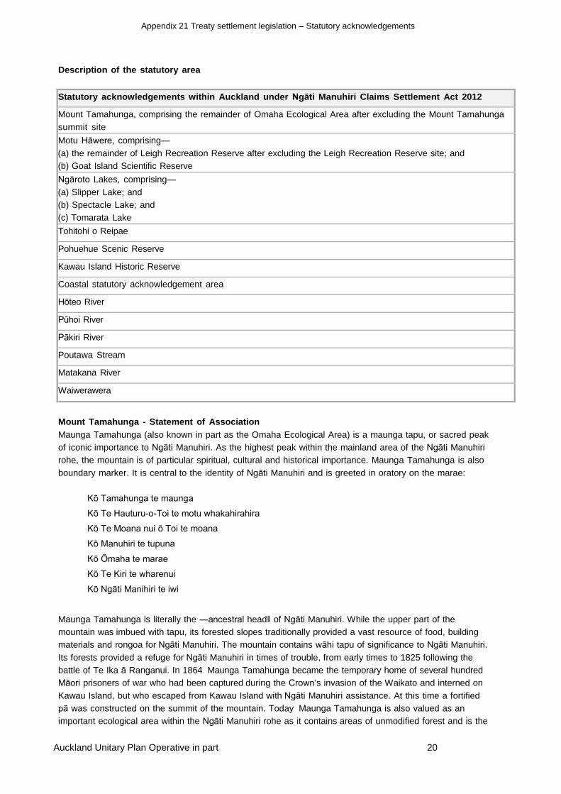
Description of the statutory area
Statutory acknowledgements within Auckland under Ngāti Manuhiri Claims Settlement Act 2012
Mount Tamahunga, comprising the remainder of Omaha Ecological Area after excluding the Mount Tamahunga
summit site
Motu Hāwere, comprising—
(a) the remainder of Leigh Recreation Reserve after excluding the Leigh Recreation Reserve site; and
(b) Goat Island Scientific Reserve
Ngāroto Lakes, comprising—
(a) Slipper Lake; and
(b) Spectacle Lake; and
(c) Tomarata Lake
Tohitohi o Reipae
Pohuehue Scenic Reserve
Kawau Island Historic Reserve
Coastal statutory acknowledgement area
Hōteo River
Pūhoi River
Pākiri River
Poutawa Stream
Matakana River
Waiwerawera
Mount Tamahunga Statement of Association
Maunga Tamahunga (also known in part as the Omaha Ecological Area) is a maunga tapu, or sacred peak
of iconic importance to Ngāti Manuhiri. As the highest peak within the mainland area of the Ngāti Manuhiri
rohe, the mountain is of particular spiritual, cultural and historical importance. Maunga Tamahunga is also
boundary marker. It is central to the identity of Ngāti Manuhiri and is greeted in oratory on the marae:
Kō Tamahunga te maunga
Kō Te HauturuoToi te motu whakahirahira
Kō Te Moana nui ō Toi te moana
Kō Manuhiri te tupuna
Kō Ōmaha te marae
Kō Te Kiri te wharenui
Kō Ngāti Manihiri te iwi
Maunga Tamahunga is literally the ―ancestral head‖ of Ngāti Manuhiri. While the upper part of the
mountain was imbued with tapu, its forested slopes traditionally provided a vast resource of food, building
materials and rongoa for Ngāti Manuhiri. The mountain contains wāhi tapu of significance to Ngāti Manuhiri.
Its forests provided a refuge for Ngāti Manuhiri in times of trouble, from early times to 1825 following the
battle of Te Ika ā Ranganui. In 1864 Maunga Tamahunga became the temporary home of several hundred
Māori prisoners of war who had been captured during the Crown‘s invasion of the Waikato and interned on
Kawau Island, but who escaped from Kawau Island with Ngāti Manuhiri assistance. At this time a fortified
pā was constructed on the summit of the mountain. Today Maunga Tamahunga is also valued as an
important ecological area within the Ngāti Manuhiri rohe as it contains areas of unmodified forest and is the

Appendix 21 Treaty settlement legislation – Statutory acknowledgements
Auckland Unitary Plan Operative in part 21
home of significant bird species like the kākā, kākāriki and miromiro, and the pēpeke or Hochstetter‘s frog.
Motu Hāwere Statement of Association
Motu Hāwere (Goat Island) is of central importance to the identity of Ngāti Manuhiri. The area is an iconic
reminder of the early origins of Ngāti Manuhiri and their links with the earlier iwi of the area, including Ngāi
Tāhuhu.
Motu Hāwere which shelters Wakatūwhenua, has the longer traditional name of Te Hāwere ā Maki, ‘the ear
pendant belonging to Maki‘. This sacred name is associated with Maki who led the conquest of the area in the
late seventeenth century. Maki was the father of Manuhiri, the eponymous ancestor of Ngāti Manuhiri. The
mana and mauri of this name and landmark, and the waters that surround it, is thus of immense significance
to the iwi. The island was occupied as a fortified pā by the Ngāti Manuhiri warrior ancestor Maeaea, who was a
grandson of Manuhiri. It was on the basis of descent from Maeaea that Ngāti Manuhiri received title to Motu
Hāwere in 1901. The adjoining land was maintained as a kāinga and cultivation by Ngāti Manuhiri for many
generations until after early European settlement. The land, known as the Wakatūwhenua Block, part of which
forms the Leigh Recreation Reserve, was specifically reserved from sale to the Crown at the request of the
Ngāti Manuhiri rangatira Te Kiri Kaiparaoa in 1861.
The alienation of Wakatūwhenua and Motu Hāwere are symbolic of the fragmentation and loss suffered by
Ngāti Manuhiri in the colonial period. Ngāti Manuhiri nevertheless recognise the significant ecological,
scientific, educational and recreational values of Motu Hāwere and Wakatūwhenua, and are committed to
jointly conserving these values, as well as the area‘s spiritual, cultural and historical values, into the future.
Cultural, Spiritual, Historic and Traditional Association of Ngāti Manuhiri with Ngāroto (Lake
Spectacle and Slipper Lake) and Roto Tomarata (Lake Tomarata)
These three fresh water lakes are the largest sand duneimpounded lakes of their type on the eastern
coastline of the Auckland region. The two northern lakes lie inland and to the south of Te Ārai ō Tāhuhu (Te
Ārai Point) and are known jointly as Ngāroto, literally ‗the lakes‘. The southernmost lake is Roto Tomarata
named after a sacred rata tree, Te Toma rata tapu, that was an important burial place. All three lakes are
located on the Wai keri ā Wera Block which was purchased from Ngāti Manuhiri by the Crown in 1859. These
fresh water lakes and their wetland margins provided a valued source of fresh water, food and weaving
materials, and were focal points for settlement. Roto Tomarata is particularly significant to Ngāti Manuhiri as it
was one of the dwelling places of the ancestor Kahikatearoa, the son of Manuhiri, and its environs were the
resting place of many illustrious ancestors.
Cultural, Spiritual, Historic and Traditional Association of Ngāti Manuhiri with Tohitohi ō Reipae,
also known as The Dome.
Tohitohi ō Reipae is a prominent land mark lying to the north west of Puhinui (Warkworth). This mountain was
an important traditional boundary marker and is a significant historical reminder of the early ancestral origins of
Ngāti Manuhiri. The mountain takes its name from the ancient and famous Tainui ancestress Reipae, who is
said to have travelled north from the Waikato in the company of her sister, Reitu, who was seeking the hand of
a leading northern chief Ueoneone. Unusually Reipae and Reitū travelled on the back of a large pouākai or
eagle. On their journey they alighted at Taurere ō Reipae at Pākiri and then at Tohitohi ō Reipae, before finally
arriving at Whānga ā Reipae (Whāngarei). Here Reipae married the leading Ngāi Tāhuhu rangatira
Tāhuhupōtiki. Ngāti Manuhiri are descendants of this union. The mountain continues to be a significant
landmark to Ngāti Manuhiri and is valued for its ecology including the Waiwhiu kauri grove.
Cultural, Spiritual, Historical and Traditional Association of Ngāti Manuhiri with Pohuehue
Scenic Reserve
This prominent scenic reserve located beside State Highway 1 is particularly valued by Ngāti Manuhiri as a
visible and accessible remnant of the lush native forest that once covered the district. It takes its name from a
native climber, the pohuehue that was valued for its tenacity.

Appendix 21 Treaty settlement legislation – Statutory acknowledgements
Auckland Unitary Plan Operative in part 22
The name of the reserve is also valued as a reminder of the Ngāti Manuhiri ancestor Pōhuehue who was the
father of the twentieth century Ngāti Manuhiri leader Tenetahi Te Riringa.
Cultural, Spiritual, Historical and Traditional Association of Ngāti Manuhiri with Te Kawau Tūmārō ō
Toi, also known as Kawau Island
Te Kawau Tūmārō ō Toi – the sentinel cormorant of Toi – is of major cultural, spiritual, and historical
significance to Ngāti Manuhiri. The island is one of several iconic landmarks in the Ngāti Manuhiri rohe,
including Te HauturuoToi / Little Barrier Island, that were named after the illustrious ancestor Toi Te Huatahi.
Together, they form Ngā Poitō ō Te Kupenga ō Toi Te Huatahi – the floats of the fishing net of Toi – or the
islands that stand in Te Moana Nui ō Toi – the great sea of Toi (the northern Hauraki Gulf).
Through ancient whakapapa, Ngāti Manuhiri are direct descendants of Toi Te Huatahi. The relationship of Ngāti
Manuhiri with the island extends back through descent from Manaia, not only to Toi Te Huatahi but also to the
ancestor and atua, Maui. Ngāti Manuhiri came to occupy the island in the late seventeenth century after they
and their Te Kawerau relatives defeated the local people at the battle of Huruhuruwaea on the adjoining
mainland. Ngāti Manuhiri occupied Kawau Island mainly for the purpose of fishing, as its soils were infertile and
there was a shortage of fresh water in summer. Occupation by Ngāti Manuhiri continued until the disruption of
Te Pakanga ā Te Pū the musket wars of the 1820s and 1830s. After the alienation of the island without the
participation of Ngāti Manuhiri in the 1840s, the iwi continued to maintain kāinga on the mainland immediately
adjoining Kawau Island at Mangatāwhiri (Jones Bay), Tāwharanui, and Waikauri, which was occupied until
1912. Ngāti Manuhiri sailing vessels, operated by rangatira such as Tenetahi Te Riringa, provided a trading
service for the copper mine on the island until the 1850s, and later for Sir George Grey who purchased Kawau
Island in 1862. This shipping service was maintained by Tenetahi‘s sons Wi Taiawa Paraone and Kiri Paraone
until the early twentieth century. The Ngāti Manuhiri rangatira Te Kiri Kaiparaoa visited Grey regularly on the
island during the 1860s and, according to Ngāti Manuhiri tradition, was presented with a sword at Mansion
House at around 1864. Since the 1980s Ngāti Manuhiri has assisted the Hauraki Gulf Marine Park Board, and
its successor the Department of Conservation, in planning for the management of the historic reserve.
Statement of Association for the Ngāti Manuhiri Coastal Statutory Acknowledgement Area
The coastal marine area and the coastal environment adjoining are central to the origins, mana and identity of
Ngāti Manuhiri as an iwi, and as part of the oceanfocused tribal grouping Ngāti Wai ki te Moana.
Ngāti Manuhiri have an important ancestral relationship with the coastal marine area extending from
Mangawhai (the Mangawhai Harbour) to Matakanakana (the Matakana Estuary). Broader and shared ancestral
interests are also maintained within a coastal area covering the seaway known as Te Moana Nui ō Toi – the
great sea of Toi (the central and northern Hauraki Gulf). In the north, Ngāti Manuhiri share ancestral
relationships and interests from Paepae ō Tū (Bream Tail) on the eastern coastline, out to the islands of Tūturu
(Sail Rock) and Pokohinu (the Motuhinau Islands group).
The Ngāti Manuhiri coastal statutory acknowledgement area encompasses the islands of HauturuoToi / Little
Barrier Island, and Aotea (Great Barrier Island), where Ngāti Manuhiri have shared ancestral interests,
including on Rangiahua (Flat Island), Motu Mahuki, Motu Taiko, and their marine environs. Ngāti Manuhiri
accept that their relatives Ngāti Rehua act as primary kaitiaki of these interests at Aotea.
The southern boundary of the Ngāti Manuhiri coastal statutory acknowledgement area extends from the south
western extremity of Aotea (Great Barrier Island) through the seas known traditionally as Taitūmata and Te
Awanui ō Hei, to Takapou (Channel Island). It then runs westward through the seaway known as Moana Te
Rapu, to the south of the Whāngaparāoa Peninsula, to reach the eastern coastline of the Auckland region at
Ōkura. There are places of spiritual, historical, cultural and economic importance to Ngāti Manuhiri along the
entire coastline between Ōkura and Paepae ō Tū (Bream Tail). Seaways of particular significance to Ngāti
Manuhiri include Waimiha (Ōmaha Bay) which was associated with the annual whale migrations described
below, Moanauriuri (Kawau Bay), and Waihi (the North Channel of Kawau Bay). This latter area is a place of
particular mana associated with the landmarks and ritually important areas of Karangatuoro, Matatūahu,
Appendix 21 Treaty settlement legislation – Statutory acknowledgements
Auckland Unitary Plan Operative in part 23
Tangaroa and Tokatū.
Te Moana Nui ō Toi Te Huatahi – The Great Sea of Toi Te Huatahi
Ngāti Manuhiri trace descent from the famous early Māori ancestor and voyager Toi Te Huatahi, after whom Te
Moana Nui ō Toi (the central and northern Hauraki Gulf) is named. This ocean area, and its mauri or spiritual
essence, kaitiaki or spiritual guardians, biodiversity, seaways, islands, and traditions, lie at the heart of the
identity of Ngāti Manuhiri. Te Moana Nui ō Toi, and its islands and coastal margins are also associated with
the earliest ancestral origins of Ngāti Manuhiri, through descent from the ancestors Maui Pae, Manaia, and
Tahuhunuiorangi. This seaway was also associated with the arrival of the Tainui and Aotea waka in the region,
and the renowned ancestors Rakataura and Turi from whom the eponymous ancestor Manuhiri descends.
The importance of the coastal area to Ngāti Manuhiri over many generations is reflected by ancient whakataukī
and waiata, traditions associated with the ocean, the sailing and navigational skills of the tribe, and the
adornment of Ōmaha Marae as the present day focal point of the iwi today. Tradition tells us that Te Moana Nui
ō Toi was a place of arrival for famous ancestral voyaging canoes, a place intimately associated with the early
ancestors of Ngāti Manuhiri, a place that is watched over by kaitiaki or spiritual guardians, and a vast economic
resource that was jealously guarded and coveted over many generations.
Ngā Pōito ō Te Kupenga ō Toi Te Huatahi – The Floats of the Fishing Net of Toi Te Huatahi
The motu (islands), motu nohinohi (islets) and kōhatu (rocks) that lie within the coastal area of significance to
Ngāti Manuhiri are known collectively as Ngā Pōito ō Te Kupenga ō Toi Te Huatahi – ―the floats of the fishing
net of Toi Te Huatahi‖. Several of them are particularly significant as they carry the name of the ancestor Toi,
with examples being Ngā Taratara ō Toi (―the Needles at the northern tip of Aotea‖), Te Kawau Tūmārō ō Toi
(Kawau Island), and Te HauturuoToi / Little Barrier Island. The following waiata oriori (lullaby) illustrates the
collective spiritual unity of these islands, and their importance to Ngāti Manuhiri, who occupied HauturuoToi /
Little Barrier Island until 1896.
Me piki taua ki
te tihi ō Hauturu
muia ao.
Ka matakitaki taua
ki ngā pōito ō te
kupenga ō Toi Te
Huatahi.
E tama tangi kine, ē!
Let us climb to the summit
of Hauturu wreathed in cloud.
Here we can view
the floats of the fishing net of Toi Te
Huatahi. Oh child crying distressfully, e!
The larger islands were occupied permanently, provided a wide range of food and were protected by fortified pā.
Of particular importance were the manu oi (mutton bird species) that were harvested in early summer and
preserved in their own fat. This delicacy was traditionally offered to distinguished guests and was central to the
identity of Ngāti Manuhiri. The widespread introduction of pests such as the ship rat, and the alienation of the
islands in the nineteenth century, made it difficult for Ngāti Manuhiri and others to obtain manu oi. Ngāti
Manuhiri continued to accompany their relatives to harvest tītī from Pokohinu (the Mokohinau Island Group)
until wartime restrictions were introduced around 1940.
Ngā Tohorā Kaitiaki ā Manaia – “the Guardian Whales of Manaia”
Several of the islands located within Te Moana nui ō Toi hold significance to Ngāti Manuhiri as descendants of
the renowned northern ancestor Manaia I. Ngāti Manuhiri tradition explains that the ancestor Manaia I
communed with the vast numbers of whales that migrated though the seas off the eastern coast of the region.

Appendix 21 Treaty settlement legislation – Statutory acknowledgements
Auckland Unitary Plan Operative in part 24
A retinue of whales always accompanied him on his voyages and became his mōkaikai (pets). Prior to his
death, Manaia I turned several of these whales into stone and placed them throughout his ancestral domain as
markers of the area over which he held mana, and as kaitiaki (guardians) for his descendants. The kaitiaki
that are associated with Ngāti Manuhiri and their close relatives include: Te Tohorā ā Manaia (an islet of the
south western end of Aotea), and Te Mau Tohorā ā Manaia (Motuora Island) located to the north of the
Mahurangi Harbour entrance.
The annual whale migrations through Te Moana nui ō Toi were of major significance to Ngāti Manuhiri, and
remain so. They symbolise ancestral associations, the changing of the seasons, and the rich marine
biodiversity contained within this vast ocean area. The coastal seaways between Whāngaparāoa, ‗the bay of
the sperm whales‘, and Tokatū Point, provided a resting place for migrating whales and their calves. The seaway
lying to the north of Tāwharanui, and extending towards HauturuoToi / Little Barrier Island, was known
traditionally as Waimiha or Te Aumiha. This name has layers of meaning relating to the whale calves that rested
in the coastal waters, the ambergris cast ashore by the whales, and the heavy seas that arise in this area.
Whales often stranded on this part of the coast, in particular on the northern side of the Tokatū Peninsula,
bringing a rich bounty for Ngāti Manuhiri. On occasions whales were also caught by the young men of the tribe,
both as a symbol of manhood and as a resource.
The name of the nineteenth century Ngāti Manuhiri leader Te Kiri Kaiparaoa symbolises this activity and the
exercise of rangatiratanga:
He reirei ngā niho parāoa, he parāoa ngā kauae.
If you wear a necklace of sperm whale teeth, you need the jaws of a sperm whale to carry them.
Te Ao ō Tangaroa The Realm of Tangaroa
The seas of Te Moana Nui ō Toi provided a vast source of food for Ngāti Manuhiri over the generations,
including sea mammals, a great variety of fish, shellfish, seaweed and sea birds. Knowledge relating to the
location and resources of individually named tauranga ika (fishing grounds) was handed down over the
generations until this practice was disrupted by the introduction of modern sonar devices. Of particular
importance to Ngāti Manuhiri were tauranga ika associated with whāpuku (groper), tarakihi, tawatawa
(mackerel), tāmure (snapper), kahawai, and haku (kingfish). The tauranga mango (shark fishing grounds) of
Kawau Bay were used by Ngāti Manuhiri and others to catch the school shark species known locally as muri.
This important winter food source was coveted by iwi and became the cause of significant conflict in the
eighteenth century. Ngāti Manuhiri continued to harvest muri from this area regularly until the establishment of
a shark oil processing factory at Sandspit in the late nineteenth century, and periodically until the 1920s.
Te Takutaimoana – the Coastline
The coastline extending between the Whāngaparāoa Peninsula and Paepae ō Tū (Bream Tail) includes a wide
range of rocky, sandy and estuarine marine habitats, once rich in a variety of inshore fish species, koura and
shellfish. Ngāti Manuhiri were traditionally reliant on this kaimoana resource, which was harvested seasonally
according to strict customary practices until the alienation of most of the Ngāti Manuhiri tribal domain by the
late nineteenth century. In spite of this, the Ngāti Manuhiri rangatira Te Kiri Kaiparaoa continued to assert
rights over the resources of the coastline between Tokatū and Pākiri until his death in 1873. Prior to the
introduction of animal pest species, deforestation and land clearance in the mid nineteenth century, the coastal
environment also contained seal colonies, for example Te Pūrei Kekeno at Hāwera (Tī Point). There were also
large seabird breeding colonies on most of the larger coastal headlands from which birds and eggs were
harvested. Settlement was focused around sheltered bays, harbours and river mouths, with fortified pā
protecting the resources of each of these communities. Places of special significance to Ngāti Manuhiri on this
coastline include: Tiritiri Mātangi Island, named after the Waikato birthplace of the eponymous ancestor
Manuhiri, Whangaparāoa, ―the bay of the sperm whales‖, Motu Mahurangi (Mahurangi Island), Awa
Waiwerawera (the Waiwera River), Te Awa Pūhoi (the Pūhoi River), Te Muri ō Tarariki, Waihē (the Mahurangi
River), Te Korotangi (a fortified pā), Ōpahi, Motu Kororā (Saddle Island), Matakanakana (a fortified pā), Awa
Matakanakana (Matakana Harbour and River), Purahurawai (Scandrett‘s Bay/Mullet Point), and the islands of
Te Mau Tohorā ā Manaia (Motuora), Moturekareka, Motumanu, Motuketekete, Taungamārō, Takangaroa,

Appendix 21 Treaty settlement legislation – Statutory acknowledgements
Auckland Unitary Plan Operative in part 25
Ruakoura, Tangaroa, and Te Kawau Tūmārō ō Toi (Kawau Island). The coastline extending from
Matakanakana northward around the Tokatū Peninsula to Whāngateau contains numerous areas of
significance to Ngāti
Manuhiri. These include traditional inshore fishing grounds, netting and kaimoana gathering areas, pā, kāinga,
wāhi tapu, tūahu, and navigational and historical landmarks. Examples are provided by: Waimarumaru, Wai
ihe, Pākaraka, Karangatuoro, Te Ngaere, Waikauri, Matatūahu, Ōponui (a fortified pā), Mangatāwhiri, Pāhī (a
fortified pā), Tokatū, Waikōkōwai, Pukeruhiruhi (a fortified pā), Waimaru, Waitapu, Te Kiekie, Te Wairenga and
Te Taumutu (Ōmaha Spit), Whāngateau, Waikōkopu, Uruhau, Pātito (a fortified pā), Koekoea (a fortified pā),
Hāwera, Te Pūrei Kekeno, Piupiu (a fortified pā), Kohuroa (Matheson Bay), Whānga ō maha (Leigh Harbour),
Panetiki, Motururu, Wakatūwhenua, Motu Hāwere, Ōkākari (a fortified pā), Pitokuku, Taumata (a fortified pā),
Ngā One Haea (Pākiri Beach), Te Ārai ō Tāhuhu (a fortified pā), Mangawhai, and Paepae ō Tū (Bream Tail).
Several of these coastal sites, including the main harbours and the region‘s longest east coast beach, are of
particular significance to Ngāti Manuhiri as outlined below.
Mangawhai Harbour
Mangawhai – ―the estuary of the whai‖ (stingray) – is of major historical, cultural and spiritual importance to
Ngāti Manuhiri. Mangawhai was one of the homes of Kahikatearoa, the son of Manuhiri. The estuary provided
shelter for those travelling by canoe from Mahurangi to Whāngarei. An overland pathway also linked the head of
the harbour at Ōawatea with the Ōruāwharo area on the Kaipara Harbour. A variety of fish were netted from the
harbour, although this did not include the whai which is a kaitiaki to Ngāti Manuhiri. Following the battle of Ika ā
Ranganui fought against a combined northern force near Kaiwaka in 1825, heavy losses were sustained by
Ngāti Manuhiri at Mangawhai and Te Ārai. As a result the area became tapu and was not permanently
occupied at the time of early European settlement.
Ngā One Haea – Pākiri Beach
The coastline adjoining Ngā One Haea (Pākiri Beach) has long been renowned for its high quality ‗glistening
white sand‘, which is the origin of its traditional name. The beach provided an important coastal pathway until
the mid nineteenth century and remains emblematic to the identity of Ngāti Manuhiri. Settlements were
located right along the beach, with a focus on the stream mouths and the duneimpounded freshwater lakes.
These settlements were protected by fortified pā, including: Ōkakari, Pākiri and Taurere o Rei in the south,
Whetūmākurukuru, Ōpuāwanga and Putukākā in the central area, and Te Ārai ō Tāhuhu in the north.
Kaimoana taken from the seas adjoining Ngā One Haea sustained Ngāti Manuhiri over the generations, and
continues to enable the provision of hospitality at Ōmaha Marae. A particular feature were tuatua harvested
from the beach, as well as paua and kūtai (mussels) taken from Pitokuku, Wakatūwhenua and Motururu.
Pākiri was famed for the snapper run that took place in September, with thousands of fish being dried and
smoked. Kanae (mullet) were netted in large numbers along the beach and in the Pākiri River, and kahawai
were caught around the river and stream mouths. Makawhiti (herrings) and inanga (whitebait) were also prolific
in the Pākiri River.
The coastline adjoining the southern end of Ngā One Haea is associated with the largest remaining Ngāti
Manuhiri community at Pākiri, and is of symbolic importance as the last piece of coastal land on the east
coast remaining in Māori ownership between Auckland and Whāngarei. The Ngāti Manuhiri relationship with
PākiriMangawhai coastal sand resource was recognised by the Planning Tribunal in 1993.
Whānga ō Maha – Leigh Harbour
Whānga ō Maha is the traditional name for Leigh Harbour. This name refers to the importance of the harbour
and the wide variety of natural resources that it offered. It gives its name to Ōmaha Marae and the Ōmaha
Block located on the northern side of the harbour. This name of major significance to Ngāti Manuhiri became
mislocated to the Whāngateau area in the late nineteenth century. The harbour offered a wide variety of
kaimoana resources. It provided a sheltered anchorage and hauling out place for waka, and later for sailing
vessels and fishing launches operated by Ngāti Manuhiri. The islet of Panetiki at the harbour entrance remains

Appendix 21 Treaty settlement legislation – Statutory acknowledgements
Auckland Unitary Plan Operative in part 26
in the ownership of Ngāti Manuhiri, as does a coastal landing place providing access to Ōmaha Marae and
Urupā.
Whāngateau Harbour
Whāngateau, ‗the harbour of the strong tidal current‘, is a place of considerable historical and cultural
significance. The traditional importance of this large harbour is illustrated by the fact that its resources were
protected by six fortified pā. The sandbanks of the lower harbour and the Waikōkopu Inlet provided the most
important source of pipi and tuangi (cockle) shellfish within the Ngāti Manuhiri rohe. A wide variety of fish could
be caught around the harbour entrance and koura (crayfish) were taken from the rocky coastline surrounding
Hāwera (Tī Point). A special delicacy traditionally associated with Whāngateau was the kūaka (godwit) that
was harvested in summer. The coastal land surrounding Whāngateau was part of the controversial ‗Dacre‘s
Claim‘. Ngāti Manuhiri occupied Whāngateau until the late nineteenth century, and continue to harvest
resources there today.
Waihē – Mahurangi Harbour
Ngāti Manuhiri have a shared ancestral interest in Waihē (the Mahurangi Harbour) as descendants of Maki and
his wife Rotu who occupied Te Korotangi Pā at the southern harbour entrance. Places of particular
significance to Ngāti Manuhiri include: the island pā of Maunganui (Casnell Island), Motu Kauri (Grant‘s Island),
Puhinui (the waterfalls at Warkworth), and Pukapuka Cemetery which remains in use at the head of the
harbour. The traditional name for the harbour originates from the fact that its resources were jealously guarded
and fought over down the generations. Kō te iti ō Waihē, he puta kino nui – ―Even though Waihē (the
disputed harbour) is not large, it has been the cause of great trouble.
Ongoing Association with the Coastal Area
Following the alienation of most of their coastal land in the nineteenth century, Ngāti Manuhiri continued to
utilise the resources of the coastal marine area. The Ngāti Manuhiri rangatira Te Kiri Kaiparaoa operated the
coastal trading vessel Industry from 1858. His son in law Tenetahi Te Riringa was a renowned sailing captain,
operating such vessels as the Rangatira, and his sons Wi Taiawa and Kiri Paraone ran a trading service and
commercial fishing operation out of Whānga ō Maha (Leigh Harbour) for many years. Ngāti Manuhiri were
involved in commercial fishing operations in the area until recently, and continue to hold significant commercial
fishing interests through the Ngāti Wai Trust Board. Ngāti Manuhiri were associated with the establishment and
operation of the Hauraki Gulf Maritime Park in 1967, and have more recently played an active role on the
Hauraki Gulf Forum established under the provisions of the Hauraki Gulf Marine Park Act (2000). In their role
as kaitiaki, Ngāti Manuhiri continue to play an active role in coastal planning, monitoring and management
processes administered by the council and the Department of Conservation. Ngāti Manuhiri has also played an
active partnership role with the council in the establishment and management of the Tāwharanui Open
Sanctuary ecological restoration project, and its associated Marine Protection Area. As the iwi develops further
capacity it looks forward to being fully engaged in exercising kaitaikitanga in partnership with other iwi, the
Crown and the wider community, within its coastal acknowledgement area.
Cultural, Spiritual, Historic and Traditional Association of Ngāti Manuhiri with the Hōteo River.
Kō Hōteo te awa
Kō Mangatū te pā
Kō Manuhiri te tangata
Kō Ngāti Manuhiri te iwi
Te Awa Hōteo (the Hōteo River) was an important traditional resource of Ngāti Manuhiri, and it remains a water
body of major cultural, spiritual and historic significance to the iwi. The river has particular importance as the
home of the eponymous ancestor Manuhiri who occupied pā at Tūtā, Umukuri and Mangatū where he lived until
his death. The lower reaches of the river were also an important boundary marker between Ngāti Manuhiri and
other groups. Until the late 1860s the lower river was the focal point of settlement for Uri ō Katea, a hapū of
Ngāti Manuhiri who descended from Tūwhakaeketia, the second son of Manuhiri. Of special importance are
Appendix 21 Treaty settlement legislation – Statutory acknowledgements
Auckland Unitary Plan Operative in part 27
Taihāmau and Iriwata, the sons of Tūwhakaeketia, who stand as stones in the river. They are located just above
the Tarakihi rapids which marked the navigable upper reaches of the river.
From the time Ngāti Manuhiri settled the area in the late seventeenth century, kāinga and cultivations were
maintained beside many parts of the river including at Hōteo, Te Awapū, Mangakura, Mangatū, Awa Matangao
and Kawakawa. The Hōteo River provided a wide range of fish, eels, kākahi and water fowl. Kāinga on the
lower part of the river were renowned for their karaka groves from which ripe kernels were harvested in autumn.
As the river extended many kilometres inland to Tomarata and Whāngaripo it provided a traditionally important
eastwest transport route.
Cultural, Spiritual, Historic and Traditional Association of Ngāti Manuhiri with Te Awa Pūhoi, also
known as the Pūhoi River
Te Awa Pūhoi, also known as the Pūhoi River, and its tributaries Manga Hikauae and Manga Mihirau are of
significance to Ngāti Manuhiri. Manuhiri, the eponymous ancestor of Ngāti Manuhiri, and his brothers
Ngāwhetū and Maeaeariki lived beside the river in the late seventeenth century. The river provided an important
inland route and food source. The river and its environs are also associated with several events of considerable
importance in the traditions of Ngāti Manuhiri. At Mihirau on the upper reaches of Te Awa Pūhoi a major
peacemaking meeting was convened by Ngāti Manuhiri and their Te Kawerau relatives with another iwi. The
granddaughter of Manuhiri, Te Kupe, was betrothed to a chief of this other iwi. The union was not successful
and further conflict took place. When the land around the upper reaches of the river was sold to the Crown in
1862, the Ngāti Manuhiri rangatira Te Kiri Kaiparaoa sought the protection of a major wāhi tapu at Pūhoi
because of its association with his ancestors.
Cultural, Spiritual, Historic and Traditional Association of Ngāti Manuhiri with the Pākiri River
Te Awa Pākiri (the Pākiri River) has been an important resource and landmark for Ngāti Manuhiri from the
earliest period of settlement until the present. The river takes its name from Pākiri, the headland pā which has
guarded its mouth from the time of Kahikatearoa, son of Manuhiri. The river was navigable for several
kilometres and provided a sheltered anchorage for both river and ocean going canoes. It also provided an
important source of food which included tuna (eels), kanae (mullet), and waterfowl. Weaving and building
materials were gathered from the lower reaches of the river at Raupōroa. The river also marked the southern
boundary of the Pākiri Block which was the largest area of land retained by Ngāti Manuhiri after Crown
purchases of the mid nineteenth century. The river remains central to the identity of Ngāti Manuhiri today.
Cultural, Spiritual, Historic and Traditional Association of Ngāti Manuhiri with the Poutawa Steam
Wai Poutawa, also known as the Poutawa Stream, and its associated wetland was a focal point for Ngāti
Manuhiri settlement on the coastline between Pākiri and Te Ārai ō Tāhuhu (Te Ārai Point) until the mid nineteenth
century. Wai Poutawa formed part of an old subtribal boundary, and marked the northern edge of the Pākiri
Block which Ngāti Manuhiri retained after the first round of Crown land purchases were completed in the 1850s
and 1860s. The outlet to the Poutawa Stream provided a permanent source of fresh water on an otherwise dry
stretch of coastline. Its wetlands provided an important source of food such as eels, inanga (whitebait), kākahi
(fresh water mussels), koura (fresh water crayfish) and water fowl, as well as weaving materials. Taro was
cultivated on the stream and wetland margins.
The lower reaches of the stream have major historical significance as they were redirected through a drain
dug by the Ngāti Manuhiri ancestor Wera in the mid eighteenth century. This feature, known as Te Waikeri
ā Wera, was the source of the name for the wider surrounding area. The area around the stream is also of
particular significance as it was occupied by Kahikatearoa, the son of Manuhiri, and his descendants until
the 1870s. The stream marked the eastern end of an overland pathway extending west to the head of the
Hōteo River catchment. Because of its strategic importance, Wai Poutawa and its environs were protected by
two fortified pā named Ōpuawhango and Ngā Whetū Mākurukuru.
Cultural, Spiritual, Historic and Traditional Association of Ngāti Manuhiri with Te Awa
Matakanakana the Matakana River
Appendix 21 Treaty settlement legislation – Statutory acknowledgements
Auckland Unitary Plan Operative in part 28
Te Awa Matakanakana (also known as the Matakana River) is of major significance to Ngāti Manuhiri as a
sub regional boundary marker. In 1853 the Crown identified the area north of the river as ‗Parihoro‘s
Claim‘, with Parihoro then being the oldest Ngāti Manuhiri rangatira in occupation of the district. The river
provided an important inland route to kāinga and cultivations located on the fertile country located at the
navigable head of the river. It also provided a wide range of food taken from both the fresh and saltwater
sections of the river. Beyond the river mouth was one of the most valued tauranga mango (shark fishing
grounds) in the region. Here over many generations, down to the late nineteenth century, Ngāti Manuhiri
and their relatives gathered large quantities of school sharks known locally as muri. The upper reaches of
the Matakana River were protected by several pā, including Pukematekeo, while the lower reaches and the
adjoining harbour were protected by the headland pā known as Matakanakana – the glowering eyes‘. This
pā, which is of considerable significance to Ngāti Manuhiri, gives its name to the river and the surrounding
district.
Cultural, Spiritual, Historic and Traditional Association of Ngāti Manuhiri with Awa
Waiwerawera
Awa Waiwerawera (the Waiwera River) is a water body of cultural, spiritual and historical significance
to Ngāti Manuhiri. This ancestral relationship with the river and its environs, including Waiwerawera
(the Waiwera Hot Springs), is shared with other iwi. Motu Mahurangi, the island at the mouth of the
river is important in Ngāti Manuhiri tradition. The river mouth area is also important as it was here that
Ngāti Manuhiri fought with Ngāti Manaia. In a subsequent peace making agreement, Tukituki of Ngāti
Manuhiri was betrothed to the Ngāti Manaia rangatira Rangihokaia. A place of particular importance at
the head of the river is the island wāhi tapu known as Motutere (Te Kōroto). The river and its margins
are also of significance to Ngāti Manuhiri because of their high ecological values in a coastal
environment that has been the subject of ongoing development pressure.

Appendix 21 Treaty settlement legislation – Statutory acknowledgements
Auckland Unitary Plan Operative in part 29
Appendix 21.4 Ngāti Whātua o Kaipara The following text is relevant to Auckland Council from Ngāti Whātua o Kaipara Claims Settlement Act
2013. The numbering below is from the Act.
65 Recording statutory acknowledgement on statutory plans
1. On and from the effective date, a relevant consent authority must attach information recording the
statutory acknowledgement to all statutory plans that wholly or partly cover a statutory area.
2. The information attached to a statutory plan must include—
a. the relevant provisions of sections 60 to 64, 66, and 67 in full; and
b. the description of statutory areas; and
c. the statements of association.
3. The attachment of information to a statutory plan under this section is for the purpose of public
information and, unless adopted by the relevant consent authority as part of the statutory plan,
the information is not
a. part of the statutory plan; or
b. subject to the provisions of Schedule 1 of the Resource Management Act 1991.
59 Interpretation
In this subpart, unless the context otherwise requires,—
affected person has the meaning given in section 2AA(2) of the Resource Management Act 1991
relevant consent authority, in relation to a statutory area, means each consent authority of the region or
district that contains, or is adjacent to, the statutory area
statement of association, for a statutory area, means the statement—
a. that is made by Ngāti Whātua o Kaipara of their particular cultural, spiritual, historical, and
traditional association with the statutory area; and
b. that is in the form set out in part 2 of the documents schedule
statutory acknowledgement means the acknowledgement made by the Crown in section 60 in respect of
each statutory area, on the terms set out in this subpart
statutory area means an area that is specified in Schedule 3 and whose general location is indicated on the
deed plan referred to in relation to that area
statutory plan—
a. means a district plan, regional coastal plan, regional plan, regional policy statement, or
proposed policy statement as those terms are defined in section 43AA of the Resource
Management Act 1991; and
b. includes a proposed plan as defined in section 43AAC of that Act.
60 Statutory acknowledgement by the Crown
The Crown acknowledges the statements of association.
61 Purposes of statutory acknowledgement
The only purposes of the statutory acknowledgement are to—
a. require relevant consent authorities, the Environment Court, and the Historic Places Trust to have
regard to the statutory acknowledgement, in accordance with sections 62 to 64; and
b. require relevant consent authorities to provide summaries of resource consent applications or, as
the case requires, copies of notices of applications to the trustees in accordance with section 66;
and
Appendix 21 Treaty settlement legislation – Statutory acknowledgements
Auckland Unitary Plan Operative in part 30
c. enable the trustees or any member of Ngāti Whātua o Kaipara to cite the statutory
acknowledgement as evidence of the association of Ngāti Whātua o Kaipara with the relevant
statutory area, as provided for in section 67.
62 Relevant consent authorities to have regard to statutory acknowledgement
1. This section applies in relation to an application for a resource consent for an activity within,
adjacent to, or directly affecting a statutory area.
2. On and from the effective date, a relevant consent authority must have regard to the
statutory acknowledgement relating to the statutory area in deciding, under section 95E
of the Resource Management Act 1991, whether the trustees are affected persons in
relation to the activity.
3. Subsection (2) does not limit the obligations of a relevant consent authority under the
Resource Management Act 1991.
63 Environment Court to have regard to statutory acknowledgement
1. This section applies to proceedings in the Environment Court in respect of an application for a
resource consent for an activity within, adjacent to, or directly affecting a statutory area.
2. On and from the effective date, the Environment Court must have regard to the statutory
acknowledgement relating to the statutory area in deciding, under section 274 of the Resource
Management Act 1991, whether the trustees are persons with an interest in the proceedings
greater than that of the general public.
3. Subsection (2) does not limit the obligations of the Environment Court under the Resource
Management Act 1991.
64 Historic Places Trust and Environment Court to have regard to statutory acknowledgement
1. This section applies if, on or after the effective date, an application is made under section 11 or
12 of the Historic Places Act 1993 for an authority to destroy, damage, or modify an
archaeological site within a statutory area.
2. The Historic Places Trust must have regard to the statutory acknowledgement relating to the statutory area—
a. in exercising its powers under section 14 of the Historic Places Act 1993 in
relation to the application; and
b. in determining whether the trustees are persons directly affected by an extension of time.
3. The Environment Court must have regard to the statutory acknowledgement relating to the statutory area—
a. when it determines, under section 20 of the Historic Places Act 1993, an appeal against a
decision of the Historic Places Trust in relation to an application; and
b. when it determines whether the trustees are persons directly affected by the decision.
4. In this section, archaeological site has the meaning given in section 2 of the Historic Places Act 1993.
66 Provision of summaries or notices of certain applications
1. Each relevant consent authority must, for a period of 20 years on and from the effective date,
provide the following to the trustees for each resource consent application for an activity within,
adjacent to, or directly affecting a statutory area:
a. a summary of the application, if the application is received by the consent authority; or
b. a copy of the notice, if the application is served on the consent authority under section
145(10) of the Resource Management Act 1991.

Appendix 21 Treaty settlement legislation – Statutory acknowledgements
Auckland Unitary Plan Operative in part 31
2. A summary provided under subsection (1)(a) must be the same as would be given to an
affected person under section 95B of the Resource Management Act 1991, or as may be
agreed between the trustees and the relevant consent authority.
3. The summary must be provided—
a. as soon as is reasonably practicable after an application is received by the relevant consent
authority; but
b. before the relevant consent authority decides under section 95 of the Resource
Management Act 1991 whether to notify the application.
4. A copy of a notice must be provided under subsection (1)(b) not later than 10 working days after
the day on which the relevant consent authority receives the notice.
5. The trustees may, by notice in writing to a relevant consent authority,—
a. waive the rights to be notified under this section; and
b. state the scope of that waiver and the period it applies for.
6. An obligation under this section does not apply to the extent that the corresponding right has been waived.
7. This section does not affect the obligation of a relevant consent authority to decide,—
a. under section 95 of the Resource Management Act 1991, whether to notify an application:
b. under section 95E of that Act, whether the trustees are affected persons in relation to an activity.
67 Use of statutory acknowledgement
1. The trustees and any member of Ngāti Whātua o Kaipara may, as evidence of the association
of Ngāti Whātua o Kaipara with a statutory area, cite the statutory acknowledgement relating
to that area in submissions concerning activities within, adjacent to, or directly affecting the
statutory area that are made to or before—
a. the relevant consent authorities; or
b. the Environment Court; or
c. the Historic Places Trust; or
d. the Environmental Protection Authority or a board of inquiry under Part 6AA of the
Resource Management Act 1991.
2. The content of a statement of association is not, by virtue of the statutory acknowledgement,
binding as fact on—
a. the bodies referred to in subsection (1); or
b. parties to proceedings before those bodies; or
c. any other person who is entitled to participate in those proceedings.
3. However, those bodies and persons may take the statutory acknowledgement into account.
4. To avoid doubt,—
a. neither the trustees nor members of Ngāti Whātua o Kaipara are precluded from stating
that Ngāti Whātua o Kaipara has an association with a statutory area that is not
described in the statutory acknowledgement; and
b. the content and existence of the statutory acknowledgement do not limit any statement made.
68 Application of statutory acknowledgement to river, stream, and harbour
In relation to the statutory acknowledgement,—

Appendix 21 Treaty settlement legislation – Statutory acknowledgements
Auckland Unitary Plan Operative in part 32
harbour includes the bed of the harbour and everything above
the bed river or stream—
a. means—
i.
ii.
a continuously or intermittently flowing body of fresh water, including a modified watercourse; and
the bed of the river or stream; but
b. does not include—
i.
ii.
iii.
iv.
a part of the bed of the river or stream that is not owned by the Crown; or
land that the waters of the river or stream do not cover at their fullest flow without overlapping its
banks; or
an artificial watercourse; or
(iv) a tributary flowing into the river or stream.

Appendix 21 Treaty settlement legislation – Statutory acknowledgements
Auckland Unitary Plan Operative in part 33
69 Exercise of powers and performance of functions and duties
1. The statutory acknowledgement does not affect, and may not be taken into account by, a person
exercising a power or performing a function or duty under legislation or a bylaw.
2. No person, in considering a matter or making a decision or recommendation under legislation or
a bylaw, may give greater or lesser weight to the association of Ngāti Whātua o Kaipara with a
statutory area
than that person would give if there were no statutory acknowledgement for the statutory area.
3. Subsection (2) does not affect the operation of subsection (1).
4. This section is subject to the other provisions of this subpart.
70 Rights not affected
1. The statutory acknowledgement does not—
a. affect the lawful rights or interests of any person who is not a party to the deed of settlement; or
b. have the effect of granting, creating, or providing evidence of an estate or interest in, or rights
relating to, a statutory area.
2. This section is subject to the other provisions of this subpart.
Description of the statutory acknowledgement areas:
Statutory acknowledgements within Auckland under Ngāti Whātua o Kaipara Claims Settlement Act
2013, location name (deed plan reference):
Papakanui Conservation Area and Papakanui Spit Wildlife Refuge (OTS67411)
Rototoa Conservation Area and Lake Rototoa Scenic Reserve (OTS67415)
Motutara Settlement Scenic Reserve and Goldie Bush Scenic Reserve (OTS67412)
Coastal Statutory Acknowledgement Area (OTS67410)
Statements of Association
Ngāti Whātua o Kaipara statements of association are set out below. These are statements by Ngāti Whātua
o Kaipara of their particular cultural, spiritual, historical, and traditional association with identified areas.
Papakanui Conservation Area and Papakanui Spit Wildlife Refuge (as shown on deed plan
OTS67411) Papakanui Spit is a remnant of a sand plain that once extended far seaward of where it can
be seen today. The associated Waionui Inlet was, and remains, an important fishing ground, seafood and
bird gathering area, and tauranga waka (waka landing area). Humuhumu, a taniwha with the form of a
log, is also often seen from this location.
Papakanui Spit cannot be viewed in isolation, but should be viewed as a traditional site and resource hub in a
Kaipara landscape of connected kāinga (villages), pā (e.g. nearby Ngitū Pā) and use sites. The Kaipara
landscape was intimately understood by our ancestors, who practiced an economic cycle that made use of all
the resources of the region in different seasons at different places – as is attested to by the prevalence of
archaeological sites (including those associated with the Papakanui Spit).
Nā Kawharu mā te whenua nei i takahi (Kawharu and others tramped this land). This statement alludes to
the conquest of the Kaipara by Kawharu and the Ngāti Whātua ope tauā (war party) in the 17th Century. It
reflects the cultural history of the Ngāti Whātua occupation in the South Kaipara. It was through the actions
of Ngāti Whātua warriors, led by Kawharu and others, that Ngāti Whātua came to dwell in the region.

Appendix 21 Treaty settlement legislation – Statutory acknowledgements
Auckland Unitary Plan Operative in part 34
Ngāti Whātua o Kaipara have continued to be active participants in the society and development of Kaipara,
and are entwined inextricably in the history of the postTreaty of Waitangi era of this region. During this time,
the Papakanui Spit has remained a significant site for Ngāti Whātua o Kaipara. Ngāti Whātua o Kaipara have
struggled over time to preserve their resources and their intrinsic and spiritual values, and although
developments have sometimes occurred around Papakanui Spit without the support of Ngāti Whātua (e.g.
roading, reserves, (military) construction
and use, and landscaping) this does not negate the importance of the Spit to Ngāti Whātua o Kaipara. This
said, the condition of the area, its mauri, reflects our ability as ngā kaitiaki and predicts our own wellbeing.
The iwi has never ceased visiting this location or appreciating its cultural significance and we continue to
maintain an unbroken
interest in the ongoing sustainable management of the area.
Traditional resources in the area include or have included: Parāoa and Tohorā (Whales), Kekeno (Seals),
Kororā me Hoihō (Blue and Yellow eyed Penguin), Mango (Shark), Tamure (Snapper), Pātiki (Flounder),
Kanae (Mullet), Toheroa, Tio (Oyster), Tipa (Scallops), Pupu (Periwinkles), Pipi, Kuaka (Godwit), Tiitii
(Shearwater), Tōrea (Oystercatchers), Taraiti (Terns) as well as other fish, seafoods and birds, when in
season and abundance, as well as Pingao, Momo Harakeke (Various Flaxes) and other natural resources.
Rototoa Conservation Area and Lake Rototoa Scenic Reserve (as shown on deed plan OTS
67415) Rototoa is one of Ngā Tapuwaewae ō Kawharu – The Footsteps of Kawharu the giant, the famed
17th Century warrior leader who led the Ngāti Whātua warriors in the conquest of the Kaipara.
He taumata rau te toa o Kawharu (Kawharu the warrior has many places). This statement reflects the
widespread area and many significant sites where Ngāti Whātua stand in South Kaipara.
Nā Kawharu mā te whenua nei i takahi (Kawharu and others tramped this land). In this statement Ngāti
Whātua of the Kaipara honour their tūpuna who claimed Kaipara for their descendants.
These whakataukī (aphorisms) reflect the cultural history of the Ngāti Whātua occupation in the South Kaipara
and the reason Ngāti Whātua o Kaipara have continued to be active participants in the society and
development of Kaipara in the postTreaty era.
Rototoa is part of the movement and transport routes throughout the Kaipara region, a tauranga waka, a
place of recovery from war, and a fresh water resource. Rototoa is of significant spiritual value to the iwi;
kōrero (oral knowledge) is held testifying to its importance to the spiritual and cultural life and wellbeing of
Ngāti Whātua.
Rototoa cannot be seen in isolation, but should be viewed as a traditional site and resource hub in a Kaipara
landscape of connected kāinga (villages), pā (e.g. nearby Waioneke) and sites used by the tūpuna. The
Kaipara landscape was intimately understood by our ancestors, whose lives traced an economic cycle that
made use of all the resources of the region in different seasons at different places – as is attested to by the
prevalence of archaeological sites (including those associated with Rototoa).
As above, Ngāti Whātua o Kaipara have continued to be active participants in the society and development of
Kaipara in the postTreaty era, and we share in the history of the past one hundred and seventy years of this
region. During this time Rototoa has remained a significant site for Ngāti Whātua o Kaipara, who have struggled
to preserve its resources, ecology and spiritual and cultural values. Yet, although developments around Rototoa
have sometimes occurred without the support of Ngāti Whātua (e.g. roading, reserves, water infrastructure,
buildings, construction, landscaping, and the introduction of foreign species) this does not negate the
importance of Rototoa to Ngāti Whātua o Kaipara. This said, the condition of the water and surrounding land
and their mauri, reflect our ability as kaitiaki and predict our own wellbeing. The iwi has never ceased visiting
this location or appreciating its cultural significance, and shares an ongoing interest in its sustainable
management for the benefit of all.
Traditional resources in the area include or have included: Tuna (eels), Kanae (Freshwater Mullet), Kewai
Appendix 21 Treaty settlement legislation – Statutory acknowledgements
Auckland Unitary Plan Operative in part 35
(Freshwater Crayfish), Momo Kōkopu (Galaxias, Grayling), Kūkupa (Pigeon), Kiwi, Kāka, Raupō, Toetoe,
Momo Harakeke (Various flax varieties), Karaka, Rākau (assorted timber species) and other natural
resources.
Motutara Settlement Scenic Reserve and Goldie Bush Scenic Reserve (as shown on deed plan
OTS67412) This area of regenerating bush and its associated waterway is on the ‘border’ established
between Ngāti Whātua o Kaipara and Te Kawerau ā Maki through the peacemaking celebrated in the name
Taupaki. Nā Kawharu mā te whenua nei i takahi (Kawharu and others tramped this land). In this statement
Ngāti Whātua of the Kaipara honour their tūpuna who spread throughout the area.
For Ngāti Whātua o Kaipara the Mokoroa Falls (named for the taniwha there) was a tāmoko site. The area is of
significant spiritual value to the iwi, kōrero (oral knowledge) is held by members of the iwi alluding to its
importance to the spiritual and cultural life and wellbeing of Ngāti Whātua.
Goldie Bush / Mokoroa cannot be seen in isolation, but should be viewed as a traditional site and resource
hub in a Kaipara landscape of connected kāinga (villages), pā and use sites. The Kaipara landscape was
intimately understood by our ancestors, who practised an economic cycle that was attuned to cosmological
rhythms and made use of all the resources of the region in different seasons at different places – as is
attested to by the prevalence of archaeological sites (such as the pā found within the reserves area).
Ngāti Whātua o Kaipara have continued to be active participants in the society and development of Kaipara in
the postTreaty era, and thus we share in the history of the past one hundred and seventy years of this region.
During this time, the Goldie Bush / Mokoroa area has remained a location of great significance for Ngāti
Whātua o Kaipara, who have struggled to preserve its resources, ecology, and spiritual and cultural values.
Although developments have sometimes occurred around Goldie Bush / Mokoroa without the support of Ngāti
Whātua (e.g. roading and tracks, reserves, logging and dam building, construction, landscaping) this does not
negate the importance of Goldie Bush / Mokoroa to Ngāti Whātua o Kaipara. This said, the condition of the
land reflects its mauri and our ability as kaitiaki and predicts our own wellbeing. The iwi has never ceased
visiting this area or lost an appreciation of its spiritual and cultural significance or its importance to Ngāti
Whātua. We share an interest in its ongoing sustainable management and the long term direction for the whole
Waitakere area, as mana whenua.
Traditional resources in the area include or have included: Tuna (eels), Kewai (Freshwater Crayfish), Momo
Kōkopu (Galaxias, Grayling), Kūkupa (Pigeon), Kiwi, Kāka, Raupō, Toetoe, Momo Harakeke (Various flax
varieties), Karaka, Tōtara, Kauri, me ētahi atu Rākau (assorted timber species) and other natural resources.
The coastal statutory acknowledgement area (as shown on deed plan OTS67410)
Ngāti Whātua o Kaipara look to the ancestral waka that brought our tūpuna to the southern shores of the
Kaipara Māhūhū ki te Rangi, Te Wharau and Te Pōtae o Wahieroa. The iwi holds kōrero (oral history),
haka, waiata me pātere (traditional haka, songs and chants), that give embodiment to the cultural and
spiritual importance of the Kaipara to the iwi. Ko āna takutai, moana hoki ō Kaipara he ipu kai (Kaipara the
harbour, its shores and its hinterland is the foodbowl). This statement reflects the importance that the Kaipara
held and continues to hold in the fabric of Ngāti Whātua life.
The harbour cannot be seen in isolation but should be viewed as part of a Kaipara landscape of connected
kāinga (villages), pā, and resource and use sites. The Kaipara landscape was intimately understood by our
tūpuna, who practiced an economic cycle that utilised all the resources of the region in different seasons at
different places – as is attested to by the prevalence of archaeological sites (many concentrated along the
extensive coastline).
Nā Kawharu mā te whenua nei i takahi (Kawharu leading Ngāti Whātua tramped this land). This statement
explains the reason Ngāti Whātua o Kaipara have continued to be active participants in the society and
development of Kaipara in the postTreaty era. As Ngāti Whātua, we share in the history of the past one
hundred and seventy years of this region. During this time, the harbour and the coast have remained of

Appendix 21 Treaty settlement legislation – Statutory acknowledgements
Auckland Unitary Plan Operative in part 36
utmost importance for Ngāti Whātua o Kaipara, who have fought over time to preserve its resources, its
significant sites, and its cultural and spiritual values. Although developments have occurred around the
coastline, sometimes without the support of Ngāti Whātua (e.g. roading; tracks; reserves; construction;
landscaping; forest clearance; land reclamation; sand mining; dredging; commercial fishing and
aquaculture), this does not detract from the significance of the coast and harbour to Ngāti Whātua o Kaipara.
This said, the condition of the land, the harbour and the sea and their mauri, reflect our ability as kaitiaki and
predict our own wellbeing. In the postTreaty era, the bounty of kai moana and other coastal resources have
been depleted, as has the quality of the associated water itself. Ngāti Whātua have never ceased caring for or
using our takutai moana however, nor have we ever stopped appreciating its cultural and spiritual
significance, and we look forward to being a partner in its ongoing sustainable management.
The significance of the harbour is reflected in the pepeha of all Ngāti Whātua of South Kaipara who state Ko
Kaipara te moana, irrespective of which maunga (mountain), awa (river) or marae, they stand on. Although
Ngāti Whātua see the entire coastline of Kaipara as significant and interconnected, mention will be made of a
few specific locations of note:
• Maukatia – the traditional name for what became commonly known as ´Māori Bay´. A
settlement area (including the Ōtakamiro Pā) rich in marine and volcanic rock resources (used
for tools etc). The rock stack Motutara is a prominent feature off the northern end of the bay.
• Te Oneone Rangatira – the long beach stretching from Ōkiritoto Stream northwards up to
Kaipara South Head. This is a pathway for the spirits on their long journey to Te Reinga.
• Papakanui Spit.
• Manunutahi – the beach where the Ngāti Whātua tupuna Haumoewaarangi and his daughter were killed.
• Te Au Kahanga o Aotea – the landing place of the Aotea waka and the site of one of the Ngāti
Whātua parliaments.
• Puatahi and Kākānui – locations of Ngāti Whātua o Kaipara coastal marae. Cultural bases for our people in the maintenance of mana whenua / ahi kā.
Traditional resources from the harbour area include or have included: Parāoa and Tohorā (Whales), Aihe
(Dolphin), Kekeno (Seals), Kororā me Hoihō (Blue and Yellow eyed Penguin), Mango (Shark), Tamure
(Snapper), Pātiki (Flounder), Kanae (Mullet), Toheroa, Tipa (Scallops), Tio (Oyster), Kuharu, Pupu
(Periwinkles), Pipi, Kuaka (Godwit), Tiitii (Shearwater), Tōrea (Oystercatchers), Taraiti (Terns), Tuna (eels),
Kewai (Freshwater Crayfish), Momo Kōkopu (Galaxias, Grayling), Kūkupa (Pigeon), Kiwi, Kāka, as well as
other fish, seafoods and birds, when in season and abundance, and Raupō, Toetoe, Momo Harakeke (Various
flax varieties), Karaka, Tōtara, Kauri, me ētahi atu Rākau (assorted timber species), Pingao, and other natural
resources.

Appendix 21 Treaty settlement legislation – Statutory acknowledgements
Auckland Unitary Plan Operative in part 37
Appendix 21.5 Te Kawerau ā Maki The following text is relevant to Auckland Council from Te Kawerau ā Maki Claims Settlement Act
2015. The numbering below is from the Act.
33 Recording statutory acknowledgement on statutory plans
1. On and from the effective date, each relevant consent authority must attach information
recording the statutory acknowledgement to all statutory plans that wholly or partly cover a
statutory area.
2. The information attached to a statutory plan must include—
a. a copy of sections 28 to 32, 34, and 35; and
b. descriptions of the statutory areas wholly or partly covered by the plan; and
c. the statement of association for each statutory area.
3. The attachment of information to a statutory plan under this section is for the purpose of public
information only and, unless adopted by the relevant consent authority as part of the statutory plan,
the information
is not—
a. part of the statutory plan; or
b. subject to the provisions of Schedule 1 of the Resource Management Act 1991.
27 Interpretation
In this subpart,—
relevant consent authority, for a statutory area, means a consent authority of a region or district that
contains, or is adjacent to, the statutory area
statement of association, for a statutory area, means the statement—
a. made by Te Kawerau ā Maki of their particular cultural, historical, spiritual, and traditional
association with the statutory area; and
b. set out in part 4 of the documents schedule
statutory acknowledgement means the acknowledgement made by the Crown in section 28 in respect
of the statutory areas, on the terms set out in this subpart
statutory area means an area described in Schedule 1, the general location of which is indicated on the
deed plan for that area
statutory plan—
a. means a district plan, regional coastal plan, regional plan, regional policy statement, or proposed
policy statement as defined in section 43AA of the Resource Management Act 1991; and
b. includes a proposed plan, as defined in section 43AAC of that Act.
28 Statutory acknowledgement by the Crown
The Crown acknowledges the statements of association for the statutory areas.
29 Purposes of statutory acknowledgement
The only purposes of the statutory acknowledgement are—
a. to require relevant consent authorities, the Environment Court, and Heritage New Zealand Pouhere
Taonga to have regard to the statutory acknowledgement, in accordance with sections 30 to 32;
and
b. to require relevant consent authorities to record the statutory acknowledgement on statutory
plans that relate to the statutory areas and to provide summaries of resource consent
applications or copies of notices of applications to the trustees, in accordance with sections

Appendix 21 Treaty settlement legislation – Statutory acknowledgements
Auckland Unitary Plan Operative in part 38
33 and 34; and
c. to enable the trustees and any member of Te Kawerau ā Maki to cite the statutory
acknowledgement as evidence of the association of Te Kawerau ā Maki with a statutory area, in
accordance with section 35.
30 Relevant consent authorities to have regard to statutory acknowledgement
1. This section applies in relation to an application for a resource consent for an activity within,
adjacent to, or directly affecting a statutory area.
2. On and from the effective date, a relevant consent authority must have regard to the
statutory acknowledgement relating to the statutory area in deciding, under section
95E of the Resource Management Act 1991, whether the trustees are affected
persons in relation to the activity.
3. Subsection (2) does not limit the obligations of a relevant consent authority under the
Resource Management Act 1991.
31 Environment Court to have regard to statutory acknowledgement
1. This section applies to proceedings in the Environment Court in relation to an application for a
resource consent for an activity within, adjacent to, or directly affecting a statutory area.
2. On and from the effective date, the Environment Court must have regard to the statutory
acknowledgement relating to the statutory area in deciding, under section 274 of the Resource
Management Act 1991, whether the trustees are persons with an interest in the proceedings
greater than that of the general public.
3. Subsection (2) does not limit the obligations of the Environment Court under the Resource
Management Act 1991.
32 Heritage New Zealand Pouhere Taonga and Environment Court to have regard to
statutory acknowledgement
1. This section applies to an application made under section 44, 56, or 61 of the Heritage New
Zealand Pouhere Taonga Act 2014 for an authority to undertake an activity that will or may
modify or destroy an archaeological site within a statutory area.
2. On and from the effective date, Heritage New Zealand Pouhere Taonga must have regard to the
statutory acknowledgement relating to the statutory area in exercising its powers under section
48, 56, or 62 of the Heritage New Zealand Pouhere Taonga Act 2014 in relation to the
application.
3. On and from the effective date, the Environment Court must have regard to the statutory
acknowledgement relating to the statutory area—
a. in determining whether the trustees are persons directly affected by the decision; and
b. in determining, under section 59(1) or 64(1) of the Heritage New Zealand Pouhere Taonga
Act 2014, an appeal against a decision of Heritage New Zealand Pouhere Taonga in relation
to the
application.
4. In this section, archaeological site has the meaning given in section 6 of the Heritage New Zealand
Pouhere Taonga Act 2014.
34 Provision of summary or notice to trustees
1. Each relevant consent authority must, for a period of 20 years on and from the effective date,
provide the following to the trustees for each resource consent application for an activity within,
adjacent to, or directly affecting a statutory area:

Appendix 21 Treaty settlement legislation – Statutory acknowledgements
Auckland Unitary Plan Operative in part 39
a. if the application is received by the consent authority, a summary of the application; or
b. if notice of the application is served on the consent authority under section 145(10) of the
Resource Management Act 1991, a copy of the notice.
2. A summary provided under subsection (1)(a) must be the same as would be given to an affected
person by limited notification under section 95B of the Resource Management Act 1991 or as may
be agreed between the trustees and the relevant consent authority.
3. The summary must be provided—
a. as soon as is reasonably practicable after the relevant consent authority receives the application; but
b. before the relevant consent authority decides under section 95 of the Resource
Management Act 1991 whether to notify the application.
4. A copy of a notice must be provided under subsection (1)(b) not later than 10 working days after
the day on which the consent authority receives the notice.
5. The trustees may, by written notice to a relevant consent authority,—
a. waive the right to be provided with a summary or copy of a notice under this section; and
b. state the scope of that waiver and the period it applies for.
6. This section does not affect the obligation of a relevant consent authority to decide,—
a. under section 95 of the Resource Management Act 1991, whether to notify an application:
b. under section 95E of that Act, whether the trustees are affected persons in relation to an activity.
35 Use of statutory acknowledgement
1. The trustees and any member of Te Kawerau ā Maki may, as evidence of the association of Te
Kawerau ā Maki with a statutory area, cite the statutory acknowledgement that relates to that
area in submissions concerning activities within, adjacent to, or directly affecting the statutory
area that are made to or before
—
a. the relevant consent authorities; or
b. the Environment Court; or
c. Heritage New Zealand Pouhere Taonga; or
d. the Environmental Protection Authority or a board of inquiry under Part 6AA of the
Resource Management Act 1991.
2. The content of a statement of association is not, by virtue of the statutory acknowledgement,
binding as fact on—
a. the bodies referred to in subsection (1); or
b. parties to proceedings before those bodies; or
c. any other person who is entitled to participate in those proceedings.
3. However, the bodies and persons specified in subsection (2) may take the statutory
acknowledgement into account.
4. To avoid doubt,—
a. neither the trustees nor members of Te Kawerau ā Maki are precluded from stating that Te
Kawerau ā Maki has an association with a statutory area that is not described in the
statutory
acknowledgement; and

Appendix 21 Treaty settlement legislation – Statutory acknowledgements
Auckland Unitary Plan Operative in part 40
b. the content and existence of the statutory acknowledgement do not limit any statement made.
General provisions relating to statutory acknowledgement
37 Application of statutory acknowledgement to river or stream
If any part of the statutory acknowledgement applies to a river or stream, including a tributary, that part
of the acknowledgement—
a. applies only to—
i.
ii.
the continuously or intermittently flowing body of fresh water, including a modified watercourse, that
comprises the river or stream; and
the bed of the river or stream, which is the land that the waters of the river or stream cover at their
fullest flow without flowing over the banks of the river or stream; but
b. does not apply to—
i.
ii.
a part of the bed of the river or stream that is not owned by the Crown; or
an artificial watercourse.

Appendix 21 Treaty settlement legislation – Statutory acknowledgements
Auckland Unitary Plan Operative in part 41
Description of the statutory acknowledgement areas:
Statutory acknowledgements within Auckland under Te Kawerau ā Maki Act Claims Settlement Act 2015, location name (deed plan reference): Taumaihi (part of Te Henga Recreation Reserve) (OTS10604)
Motutara Settlement Scenic Reserve and Goldie Bush Scenic Reserve (OTS10610)
Swanson Conservation Area (OTS10608)
Henderson Valley Scenic Reserve (OTS10609)
Motutara Domain (part Muriwai Beach Domain Recreation Reserve) (OTS10620)
Whatipu Scientific Reserve (OTS10621)
Coastal statutory acknowledgement (OTS10614)
Waitakere River and its tributaries (OTS10613)
Kumeu River and its tributaries (OTS10611)
Rangitopuni Stream and its tributaries (OTS10612)
Te WaioPareira / Henderson Creek and its tributaries (OTS10621)
Statements of Association
Te Kawerau ā Maki statements of association are set out below. These are statements by Te Kawerau
ā Maki of their particular cultural, spiritual, historical, and traditional association with identified areas.
Motutara Domain (Part Muriwai Beach Domain Recreation Reserve): Cultural, Spiritual,
Historic and Traditional Association of Te Kawerau ā Maki with Motutara Domain
The area to which this Statutory Acknowledgement applies is the area known as Motutara Domain,
part Muriwai Beach Domain Recreation Reserve, as shown on deed plan OTS10620.
Motutara Domain (renamed Muriwai Beach Domain Recreation Reserve) is managed by the Auckland
Council as part of Muriwai Regional Park. The Domain includes a number of landmarks of considerable
spiritual, cultural and historical significance to Te Kawerau ā Maki. At the southern end of the Domain is
Maukātia (Māori Bay) which is significant as it was a landmark named by the Tainui ancestor Rakataura. In
Te Kawerau ā Maki tradition Rakataura also named the long beach (presently Muriwai Beach) that extends
to the north of the Domain “Te One Rangatira” when he journeyed along it. Maukātia was also a place
known for the manufacture of stone tools, which were fashioned from basalt taken from the cliffs behind
the bay. This process is remembered by the name of a feature on the foreshore, Te Hōangatai. Maukātia
and the sea caves at its northern end hold special significance as an ancestral burial place.
To the north of Maukātia is the headland and pā named Ōtakamiro, “the dwelling place of Takamiro”, so
named after an early Tūrehu ancestor of Te Kawerau ā Maki. Standing immediately to the west of
Ōtakamiro Point is the large rock stack known as Motutara, “the island of the seabirds”. This landscape
feature is of importance to Te Kawerau ā
Maki as part of the spiritual pathway to Te Reinga. It is now the focal point of a nationally significant
tākapu (Australasian Gannet) breeding colony. Below the headland are the sea caves known as Ngā Ana
which are wāhi tapu. At the northern end of the headland is the large rock shelf known to Te Kawerau ā
Maki as Te Tokaraerae. It was, and still is, a place renowned for fishing during calm easterly weather. The
valley behind Ōtakamiro was occupied by the Te Kawerau ā Maki rangatira Te Utika Te Aroha until the
1870s. The resources of the area were guarded by two inland fortified pā known to Te Kawerau ā Maki as
Matuakore and Tūkautū.
Te Kawerau ā Maki have maintained an ongoing interested in the Domain and were involved in the
establishment and opening of the visitor facility at the ‘Tākapu Refuge’ Australasian Gannet colony in 1979.

Appendix 21 Treaty settlement legislation – Statutory acknowledgements
Auckland Unitary Plan Operative in part 42
They also hosted the Waitangi Tribunal at the site in March 2000.
Whatipu Scientific Reserve: Cultural, Spiritual, Historic and Traditional Association of Te Kawerau
ā Maki with Whatipu Scientific Reserve
The area to which this Statutory Acknowledgement applies is the Whatipu Scientific Reserve, as shown on
deed plan OTS10621.
The 820 hectare sand accretion known as the Whatipu Scientific Reserve is an area of considerable
spiritual, historical and cultural significance to Te Kawerau ā Maki. The area is associated with the earliest
period of human settlement in the region, and with early ancestors of Te Kawerau a Maki, including Tiriwa,
Takamiro, Kupemai Tawhiti, and several Ngāoho (Tainui) ancestors.
In Te Kawerau ā Maki tradition Whatipu is associated with guardian taniwha and ancient purakau (legends)
that relate to the formation of the land. Whatipu also marks the southwestern edge of the Te Kawerau ā
Maki tribal rohe. Over many generations down to the present Whatipu has been a place famed for its
kaimoana resources and has long been a stranding place of whales. In more recent years Te Kawerau ā
Maki has played a ceremonial role in dealing with these strandings and helps manage the prized skeletal
remains and teeth of the whales.
The Whatipu Scientific Reserve is a large sand accretion that has changed size and shape significantly over
many centuries. It has particular significance to Te Kawerau ā Maki as a remaining portion of the once vast
sand accretion known as Paorae. This sandy land contained settlements and a large area of cultivations
known as Papakiekie, until most of it was eroded by the sea in the late eighteenth century.
Located within the scientific reserve are a group of islets and rocks that are known collectively as Te
Kupenga ā Taramainuku, ‘the fishing net of Taramainuku’. They include Motu Paratūtai (Paratūtai Island), Te
Toka Tapu ā Kupe
/ Ninepin Rock and Te Marotiri ō Takamiro (Cutter Rock).
Te Kawerau ā Maki continued to occupy Whatipu until well after the arrival of Europeans in the early 1850s,
with Apiata Te Aitu living on the accretion until around 1880. The Kura Track at Whatipu recalls the Te
Kawerau ā Maki kuia, Te Ipu Kura a Maki Taua, who in customary terms was a guardian of the area until her
death in 1968.
The Crown gazetted the Whatipu sand accretion as a Scientific Reserve in 2002. Te Kawerau ā Maki have
continued to play an active role in the interpretation of the area. Two carved pou, Tiriwa and Taramainuku,
stand at the
entrance to the reserve symbolising Te Kawerau ā Maki kaitiakitanga over Whatipu.
Goldie Bush Scenic Reserve and Motutara Settlement Scenic Reserve: Cultural, Spiritual,
Historic and Traditional Association of Te Kawerau ā Maki Te Taiapa.
The areas to which this Statutory Acknowledgement applies are known as Goldie Bush Scenic Reserve
and Motutara Settlement Scenic Reserve, or to Te Kawerau ā Maki as “Te Taiapa,” as shown on deed plan
OTS10610.
Te Taiapa is a place of considerable cultural, spiritual and historical significance to Te Kawerau ā Maki. The
reserve is named after a fortified pā located at the western edge of the reserve on a promontory overlooking
the Mokoroa Stream. The pā was distinguished by the fact that it was defended by “taiapa” (wooden
palisades) rather than defensive ditches. Te Taiapa was essentially a defended food store for kūmara grown
on the nearby river terraces in the locality known as Motu. It also is also a wāhi tapu and includes rakau
tapu, or trees of ritual importance.
On the western edge of the reserve is the large waterfall known as Wairere. The Mokoroa Stream which
flows from the falls is named after the taniwha Te Mokoroa who was the guardian of the surrounding area in
ancient times. One of the homes of Te Mokoroa was the pool at the base of the falls. It is known as Te Rua

Appendix 21 Treaty settlement legislation – Statutory acknowledgements
Auckland Unitary Plan Operative in part 43
ō Te Mokoroa, or “the lair of Te Mokoroa”. This part of the reserve is known as Te Patunga ō Te Mokoroa,
or “the place where Te Mokoroa was killed,” by the ancestor Taiaoroa. Te Taiapa is also valued for its
biodiversity, and in particular for its kōwhai groves which flower profusely at the onset of Kōanga or
springtime.
Adjoining the Mokoroa Stream to the north is an area of land known as Te Rua o Te Moko/Motutara
Settlement Scenic Reserve. This area was formerly a cultivation and papakāinga area occupied by Te
Kawerau ā Maki until the mid nineteenth century. Here they provided shelter to the tribes of Tāmāki
Makaurau during attacks by musket armed taua (war parties) in 1821. From Te Rua o Te Moko a pathway
extended west to Parihoa, Te Waharoa, Tirikōhua and the coastal area known as Te Ara Kānohi.
Henderson Valley Scenic Reserve: Cultural, Spiritual, Historic and Traditional Association of Te
Kawerau ā Maki with Ōpareira
The area to which this Statutory Acknowledgement applies is the area known as Henderson Valley Scenic
Reserve, or to Te Kawerau ā Maki as Ōpareira, as shown on deed plan OTS10609.
Ōpareira is a place of considerable spiritual and historical significance to Te Kawerau ā Maki. It is part of
the wider locality known as Ōpareira, “the dwelling place of Pareira”. This ancestress was the niece of the
famed early Māori voyager Toi Te Huatahi who visited the Auckland region over six centuries ago. When Toi
Te Huatahi and his people explored the Waitematā Harbour, Pareira decided to settle at Wai o Pareira near
the mouth of what is now the Henderson Creek. She and her people also occupied the Henderson Valley
area seasonally to harvest the resources of the forest. Their settlement in this area was named Ōpareira.
The area is therefore regarded and being of considerable historical importance because it is one of oldest
settled areas in the district.
The scenic reserve and the catchment area adjoining it to the west are also of major significance as the
upper part of the valley was an old burial place of Te Kawerau ā Maki for many generations. The Opanuku
Stream, which borders the reserve, is named after the ancestress Panuku, and is associated with one of
the oldest traditions of Te Kawerau ā Maki. The reserve is also valued for its biodiversity as an area of
regenerating riparian forest.
Swanson Conservation Area: Cultural, Spiritual, Historic and Traditional Association of Te
Kawerau ā Maki with Waiwhauwhaupaku
The area to which this Statutory Acknowledgement applies is the area known as the Swanson Conservation
Area, or to Te Kawerau ā Maki as Waiwhauwhaupaku, as shown on deed plan OTS10608.
Waiwhauwhaupaku is the traditional name applying to the Swanson Stream and its margins. The area
takes its name from the whauwhaupaku, or five finger shrub which once grew in profusion in the area. The
stream and its margins provided a wide range of food resources, tuna (eels), and harakeke (flax) used for
weaving and the production of cordage. In drier weather the valley was an important walking route between
the tidal head of Wai Huruhuru Manawa (known locally as Huruhuru Creek), the inland pathways leading
west to the Waitakere Valley, and east along the Pukewhakataratara ridge to the many settlements beside
the upper Waitematā Harbour. The reserve is also valued by Te Kawerau a Maki for its remnant
biodiversity and as an area of open space in an area that is coming under increasing urban pressure.
Te Henga Recreation Reserve: Cultural, Spiritual, Historic and Traditional Association of Te
Kawerau ā Maki with Taumaihi
The area to which this Statutory Acknowledgement applies is the area known as Te Henga Recreation
Reserve, or to Te Kawerau ā Maki as “Taumaihi”, as shown on deed plan OTS1064.
Taumaihi is an area of major spiritual, cultural and historical importance to Te Kawerau ā Maki. The area’s
mauri or spiritual essence, and its traditional history, are of central importance to the mana and identity of
Te Kawerau ā Maki.
Appendix 21 Treaty settlement legislation – Statutory acknowledgements
Auckland Unitary Plan Operative in part 44
Located at the northern end of Te Henga (Bethells Beach), the reserve extends from the iconic high point
and former lookout of Taumaihi above the Waitākere River mouth, past Waitākere Bay and Awa Kauwahaia
(O’Neill Bay), to Raetāhinga Point. The reserve contains iconic landmarks that feature in the traditions and
waiata of Te Kawerau ā Maki, as well as former kāinga, cultivations, pā, wahi tapu, and places of historical
and cultural significance. The present day public walkway through the reserve follows an old coastal
walkway known in Te Kawerau ā Maki tradition as Te Ara Kanohi – ‘the pathway of the eye’ – so named
because of its panoramic coastal views.
Taumaihi was originally part of the Waitākere Native Reserve. It was owned and occupied by Te Kawerau ā
Maki until the early 1900s. Seasonal kainga and gardens were maintained behind Awa Kauwahaia (O’Neill
Bay). A wide variety of kaimoana (sea food) was harvested from the adjoining coastline, and until the 1940s
tītī (muttonbirds) were harvested from Kauwahaia Island and Ōpakahā at the northern end of the reserve.
The resources of the area were formerly protected by fortified pā located at Motu Ihumoana, Motu
Kauwahaia and Tangihau, which is located within the reserve. The reserve and its immediate coastal
environs contain places of major historical significance to Te Kawerau ā Maki as they are associated with
the Ngāoho ancestress Erangi, and with the Te Kawerau ā Maki ancestor Taratūwhenua.
The reserve contains several wahi tapu, or burial places, and a site known as Te Tokaraerae which
was, and remains, an important place of ritual for Te Kawerau ā Maki. Te Kawerau ā Maki also
recognise the significant landscape and ecological values of the reserve and support their
conservation and enhancement.
Rangitopuni Stream: Cultural, Spiritual, Historic and Traditional Association of Te Kawerau ā Maki
with Manga Rangitōpuni.
The area to which this Statutory Acknowledgement applies is the area known as Rangitōpuni Stream, or to
Te Kawerau ā Maki as Manga Rangitōpuni, as shown on deed plan OTS10612.
Te Kawerau ā Maki hold significant historical, cultural and spiritual associations with Manga Rangitōpuni
and its catchment. The Rangitōpuni Stream extends inland for approximately 15 kilometres from the head of
the Waitematā Harbour at Riverhead to the extensive land block known as Pukeatua. Its large catchment is
enclosed in the north west by part of what is now Riverhead Forest and the high point of Te Ahu. In the
north east the catchment covers the areas known as Pukekauere and Paeraorao, from which flows the
tributary stream known as Huruhuru. On the east the catchment is enclosed by the sacred hill Pukeatua and
the long ridgeline known as Heruroa. The main sub catchment in this area is the Mahoenui Stream, which
extends over the area now known as Coatesville. Within this catchment is located the wāhi tapu area known
as Onehungahunga. At the south western edge of the catchment is the sacred hill known as Te Pane ō
Poataniwha, named after the Te Kawerau ā Maki ancestor Poataniwha.
Within the southern portion of the stream catchment is the locality which gives the Rangitōpuni Stream its
name. Here, in the early eighteenth century, Te Kawerau ā Maki concluded a series of peace making
meetings with another tribe, in an event known as “Rangi tōpuni”, “the day of the (gifting of) the dog skin
cloaks”.
Traditionally occupation was concentrated in the southern area of the catchment around the strategically
important area of Rangitōpuni, now known as Riverhead. At the falls marking the outlet of the Rangitōpuni
Stream were two kāinga (settlements) known as Taurangatira and Ōrangikānohi. The latter settlement was
named after a Te Kawerau ā Maki ancestress. On the southwestern edge of the lower catchment is the
locality known as Papakoura, which is a reminder of the harvesting of the fresh water crayfish, and the wide
array of food that was traditionally taken from the steam and its margins. Also located within this area of the
Rangitōpuni Stream catchment are several localities of considerable historical importance, including Te Wā
Tira, Rakau Tūrua, Kaiakeake and Moaruku. These places are of particular significance to Te Kawerau ā
Maki as they are linked with the tradition “Ruarangi haerere”, associated with the ancestor Ruarangi and his
eventful journey from Tāmaki Makaurau to Kaipara.
Appendix 21 Treaty settlement legislation – Statutory acknowledgements
Auckland Unitary Plan Operative in part 45
Waitākere River: Cultural, Spiritual, Historic and Traditional Association of Te Kawerau ā Maki
with Te Awa Waitākere
The area to which this Statutory Acknowledgement applies is the area known as the Waitākere River,
or to Te Kawerau ā Maki as Te Awa Waitākere, as shown on deed plan OTS10613.
Te Awa Waitākere is of central importance to the identity of Te Kawerau ā Maki, as illustrated by the
whakataukī: Ko Puketōtara te maunga
Ko Waitākere te awa
Ko Te Au o Te Whenua te tangata
Ko Te Kawerau ā Maki te iwi
Puketōtara is the mountain
Waitākere is the river
Te Au o Te Whenua is the man
Te Kawerau ā Maki are the people
The Waitākere River is approximately 15.5 km long with an overall catchment area of 7140 hectares. It
includes two tributary sub catchments – the Mokoroa Stream (2100 ha), and Waitī Stream (972 ha). Te
Kawerau ā Maki view the Waitākere River and its catchment in a holistic manner as a living entity, with its
physical form, biodiversity, and historical and cultural values seen as inextricably linked. The waterways,
wetlands and lakes within the catchment are seen as having their own mauri, or spiritual essence and
qualities. These vary from places where water and food are taken, to places to bathe, and places of ritual.
There are also places within the river and its catchment that are tapu and restricted.
Although the Waitākere River is seen as one entity, it has many names. The name Waitākere comes from
a wave swept rock in Waitākere Bay located between Ihumoana Island and Kōtau Point. In former times
the river turned north when it reached the coast and flowed out through this bay. The river now enters the
sea to the south of Ihumoana Island.
For generations the Kawerau people have referred to the river as Waitākere. However, its more ancient
name was “Te Awa Kōtuku”, or “the river of the white heron’s (Egretta alba modesta) plume.” This name
came from the most distinctive feature of the river, the 100metrehigh Waitākere Falls, which stand out like
a white plume against the green background of the forest. The river also had many specific locality names.
The upper section of the river was known as “Waikirikiri”, or “the stream with the stony bed”. At Waikirikiri
the river is joined by the “Waitipu”, literally “the stream that rises quickly in flood”, and the “Waitoru”, or “the
stream of the toru tree” (Toronia toru). A short distance downstream is “Te Awa mutu”, literally “the end of
the river”. It really means the point to which the river was navigable by canoe. Below that again is
“Hūkerewai”, where the river “curls about and meanders”. Further on it is joined by the “Waihoroi”
(Brissenden Stream), or literally “the stream where washing was done”. This was a name given in the late
nineteenth century, when the Kawerau ā Maki people established a camp there while they worked in
Burton’s flaxmill. At the junction of the Wairere Stream and the Waitākere River was the large lagoon
known as “Te Roto”, “the lake”, and also “Te Rua ō Te Mokoroa”, “the lair of Te Mokoroa”, the guardian
taniwha of the river. Te Mokoroa has another lair at the foot of the Mokoroa Falls, which were called
“Wairere”, “the waterfall”. Below Te Roto is another section of the river known as “Pāharakeke”, or the
“clump of flax” (Phormium tenax). This was formerly the site of an artificially constructed fortified pā, located
in the middle of the river. Here the Waitākere River slows as it reaches the shallows between Waitī and the
river mouth. This section of the river is known as “Turingoi”, or where the river “crawls along and flows
slowly”. The rocky ledge on the northern side of the river mouth is known as “Tauranga kawau”, or “the
roosting place of the shags”, which are spiritual guardians to Te Kawerau ā Maki.
The Waitī Stream sub catchment is fed by Roto Wainamu (Lake Wainamu) which means “the lake of the
sandfly or mosquito”. The lake is fed by three streams at it southern end. Firstly there is “Waitohi”, “the
Appendix 21 Treaty settlement legislation – Statutory acknowledgements
Auckland Unitary Plan Operative in part 46
stream where baptismal rites were carried out”. This is also the name of the waterfalls at the mouth of the
stream. The next stream to the west is “Waikūkū”, “the stream where the kūkupa or native pigeon
(Hemiphaga novaeseelandiae) proliferated”. To the north of Waikūkū is the stream valley known as
“Toetoeroa”, a name which refers to the expanse of toetoe (Cortaderia fulvida) which once grew there. The
stream that provides the outlet to Roto Waimanu is also known as Wainamu. It flows north until it joins two
other streams. The first is Wai ō Parekura. This is the “stream of Parekura”. “Wai ō Pare” is also the name of
the (naturally) infilled lake or swamp from which the stream drains. The main stream that flows from the
junction of Wainamu and Wai ō Pare to the Waitākere River is known as “Waitī”, “the stream of the cabbage
tree” (Cordyline species), which grows in profusion on its banks. From the stream comes the name of the Te
Kawerau ā Maki village that was located at its mouth until the 1950s.
Many kāinga (settlements) and māra (cultivations) were located beside the Waitākere River. They included
Ōhutukawa beside Lake Waimanu, Motu and Ōkaihau within the Mokoroa sub catchment, and Raumati,
Pihāriki, Parawai, and Waitī beside the lower reaches of the river. The river provided a rich source of food,
including pihariki (lamprey), kanae (mullet), tuna (eels), kokopu, inanga (whitebait), koura (fresh water
crayfish) and range of waterfowl. Its margins also provided a major source of weaving materials, including
harakeke (flax), ti (cabbage tree), raupo and kuta (sedges).
The resources of the river and its catchment were protected by fortified pā, including: Puketōtara, Te Tuahiwi
ō Te Rangi, Te Taiapa, Koropōtiki, Te Pae Kākā, Poutūterangi and Pā Kōhatu. Burial places, and places
associated with important historical events, are located throughout the Waitākere River catchment.
Today the Waitākere River wetland is seen as being of great natural and spiritual importance to Te
Kawerau ā Maki. It is a home for “the children of Tane”, including fish, eels, and birds such as the mātuku
(bittern) and the mātātā (fernbird). These animals are seen as important links, both with the ancestral
occupants, and as part of the ancient natural world which survives only in small remnant areas today.
The construction of the Waitākere Dam at the head of the catchment in 1910 (raised in height in 1927),
impacted on river flows and raised the river bed several metres. This, combined with a major kauri timber
milling operation 1925 1926, led to major and more regular flooding of the river, which in turn impacted on
the old Te Kawerau ā Maki kāinga of Waitī. It also created the Te Henga wetland which is now seen as
one of the Auckland region’s most important wetland habitats. Te Kawerau ā Maki have been involved with
local government in the planning for, and management of, the Waitākere River and its catchment since
1988.
Te Wai o Pareira/Henderson Creek: Cultural, Spiritual, Historic and Traditional Association of Te
Kawerau ā Maki with Wai o Pareira.
The area to which this Statutory Acknowledgement applies is the area known as Wai o Pareira /
Henderson Creek and tributaries, as shown on SO Plan [OTS10618].
Wai o Pareira / Henderson Creek, its tributary streams and catchment, are of considerable spiritual, historical,
traditional and cultural value to Te Kawerau ā Maki, who hold an ancestral relationship with the river dating
back over centuries. The main tributaries of Wai o Pareira drain from Hikurangi, or the central Waitākere
Ranges. The upper catchment extends for approximately fifteen kilometres from Pukematekeo in the north to
Tītīrangi and Ōkaurirahi (Kaurilands) in the south east. It contains three sub catchments and tributaries,
including: Wai Whauwhaupaku (Swanson Stream), Wai ō Panuku (Panuku Stream) and Wai Horotiu (Oratia
Stream).
Wai Whauwhaupaku is a stream of considerable significance to Te Kawerau ā Maki. It and its tributary
stream, Waimoko, flow from the eastern slopes of the sacred hill and tribal identifier Pukematekeo. In
preEuropean times the whole sub catchment was clothed in dense native forest and was renowned for its
natural resources. Wai Whauwhaupaku was so named because of the whauwhaupaku or five finger shrub
which grew in large numbers along its margins. The Waimoko tributary was named after the numerous
native geckoes found in the area, and the Paremuka tributary after the fine quality muka, or weaving variety

Appendix 21 Treaty settlement legislation – Statutory acknowledgements
Auckland Unitary Plan Operative in part 47
of flax, that grew in that stream valley. Over many generations the Wai Whauwhaupaku Stream valley was
used as an inland walkway. Canoes would be left at the head of the Wai Huruhuru Manawa (Huruhuru
Creek) tidal inlet and travellers would then walk inland to the pā above Swanson known as Pukearuhe, or
further on via the northern Pukewhakataratara ridge to the Waitākere River valley and Te Henga.
The southernmost sub catchment of Wai o Pareira is Waihorotiu (the Oratia Stream). The stream was
named after horotiu (landslips) that often occurred at the head of its catchment. It, and the middle and lower
part of the sub catchment, also take the name “Ora tia “ from the Te Kawerau ā Maki pā and kāinga of that
name located in the Holden’s Road area of Oratia. In preEuopean times the upper part of this sub catchment
was distinguished by its mature kauri forest, as remembered in the locality name Ōkaurirahi – “the place of
the huge kauri trees”.
The central sub catchment is Wai ō Panuku (the Ōpanuku Stream). It rises on the sacred slopes of the hill
known as Rua ō Te Whenua and the equally significant hill Parekura. Both places are inextricably linked in
one of the oldest traditions of Te Kawerau ā Maki. Parekura and his wife Panuku were both of chiefly birth,
and are said to have remained deeply in love throughout their lives. After his death Parekura became the
hill of that name, which stands at the head of Henderson Valley. From Parekura forever flows the stream
WaiōPanuku which embodies the spiritual essence of Panuku. At the head of this catchment is a sacred
area, formerly one of the main burial places of Te Kawerau ā Maki. In the mid catchment is an old
settlement area known as Ōpareira, “the dwelling place of Pareira”. The occupation of the lower part of the
catchment is reflected in the name of a small tributary stream, Waitaro, “the stream of the taro
cultivations”.
Wai o Pareira and Wai Horotiu meet at Te Kōpua (Falls Park, Henderson). This place, at the head of the
tidal reaches of Wai o Pareira, was of strategic importance to Te Kawerau ā Maki – it was located at the
head of navigation of the tidal river and was the beginning point for a number of inland pathways. As a result
Te Kōpua was defended by a small pā, now destroyed by urban development.
The whole tidal section of what is now commonly known as Henderson Creek is also known by the
traditional name WaiōPareira, “the river of Pareira”. (The name also applied to the bay that now contains
the West Harbour Marina). This treasured name commemorates the ancestress Pareira, who was the
niece of the renowned ancestor and voyager Toi Te Huatahi. When Toi and his people visited the
Waitematā harbour centuries ago Pareira decided to make her home at the mouth of WaiōPareira.
Te Kawerau ā Maki formerly occupied kāinga around the river mouth at Ōrukuwai on the Te Atatū Peninsula,
and at Kōpūpāka and Mānutewhau in the Massey and West Harbour area. Mānutewhau was so named
because it was a favourite place within the river for netting fish; the name literally means “the floats (of the
nets) made from whau wood”. This area around the river mouth was also a favourite place from which to
harvest tūangi (Cockles), pipi, and tio (oysters).
The stretch of water running inland to the junction with Wai Huruhuru Manawa (Huruhuru Creek) was known
traditionally as Taimatā, after its broad, “glistening waters”. The Wai Huruhuru Manawa inlet was frequently
used to travel inland, and was named after the aerial roots of the manawa (mangroves) which are a
distinctive feature of the river at low tide. Further upstream was an area that was treasured as the roosting
place of the kōtuku, white heron, during its annual northern migration. Up river of the North Western
motorway was an area known as Te Tāhuna after the sandbanks which were once there. This area was
also a favoured netting area where fish were caught in shallow water on the outgoing tide. It was also a
well known area in former times for catching tamure (snapper). In the vicinity of what is now Waitākere
Stadium, shell middens indicate the presence of former kāinga. The river margins were once famed for
their flowering kōwhai groves, the remnants of these which are still treasured. Between this point and Te
Kōpua are several wāhi tapu, or sacred areas.
Kumeu River: Cultural, Spiritual, Historic and Traditional Association of Te Kawerau ā Maki with
Te Awa Kumeū

Appendix 21 Treaty settlement legislation – Statutory acknowledgements
Auckland Unitary Plan Operative in part 48
The area to which this Statutory Acknowledgement applies is the area known as the Kumeū River, or to Te
Kawerau ā Maki as “Te Awa Kumeū”, as shown on deed plan OTS10611.
Te Kawerau ā Maki have a significant ancestral and customary relationship with Te Awa Kumeū, which is
the main waterway in the upper Kaipara River catchment. The mātāpuna, or source of the Kumeū River, is
formed by the northern slopes of Pukematekeo, a hill of spiritual significance to Te Kawerau ā Maki. The
main tributary stream in the area is the Mangatoetoe, so named because of the profusion of toetoe
(Cortaderia fulvida) which once grew along its margins. A number of small tributary streams also join the
head of the Kumeū River from the west. These
streams are important as they flow from the line of hills known as “Ngā Rau Pou Tā Maki”, “the many posts
of Maki”, so named after the Te Kawerau ā Maki ancestor Maki. These hills include Huranui,
Maungakarikari, Te Heke, Papatāwhara and Te Pou ā Maki.
The upper reaches of the Kumeū River provided a significant source of harakeke (flax) and toetoe used for
weaving purposes. The catchment was formerly clothed in kahikatea forest and was therefore an ideal place
for hunting kūkupa (native pigeons). An important westeast walkway crossed the southern extremity of the
catchment between the Waitākere River valley and Mānutewhau, Wai o Pareira and Ngongetepara
(Brigham’s Creek) on the Waitematā Harbour. The ridgeline of Ngā Rau Pou Tā Maki, marking the western
edge of the catchment, provided an important northsouth walkway between the Waitākere River valley and
the Muriwai valley.
Near the present day Taupaki village, the Kumeū River is joined by the large tributary, the Pakinui Stream.
This stream is named after a peace agreement that was reached in the area many generations ago by the
early ancestors of Te Kawerau ā Maki. This historical event was associated with the earliest known battle
fought in the district by an ancestor known as Te Kauea, who was of Ngā Tini ō Toi. From an incident in
the battle comes the name Kumeū. This area, located to the northeast of Taupaki village, gives its name
to the Kumeū River.
From its junction with the Pakinui Stream, the Kumeū River flows past a sacred locality known as Te Ahi
Pekapeka. It then reaches Te Tōangaroa, the Kaipara portage, at the southern end of what is now the
village called Kumeu.
This area was known traditionally as Waipakiirape. In preEuropean times the area was of considerable
strategic importance as it was located at the western end of a canoe portage and walking track that
extended east to Maraeroa and Pītotoi at Riverhead. Beyond Waipakiirape the Kumeū River flows to
Tūrakiawatea, which is now known by the modern name Huapai. The traditional place names
Tūrakiawatea, Waipakiīrape and Waikoukou are a reminder of the journey that the Te Kawerau ā Maki
ancestor Ruarangi, made into the district from Tāmaki Makaurau, likely in the sixteenth century. The
Kumeū River then flows west for three kilometres across an area known as Te Ihumātao. At Kāhukuri the
Kumeu River is joined by the Ahukuramu Stream (or Ahukāramuramu) from the south, and the Waikoukou
Stream from the north. Both streams are important in the history of Te Kawerau ā Maki as they were the
locations of important peacemaking meetings, known as Kāhukuri and Kāhutōpuni. Just west of the
junction of these streams is the lowlying area known as Waimauku. It was so named as when the river
was in flood only the tops of the Tī mauku (cabbage trees) were visible above the water.
After passing beyond the high point known as Taumata, the Kumeū River becomes the Kaipara River. Te
Kawerau ā Maki have a shared ancestral association with the river beyond this point north to Kōpironui,
where members of Te Kawerau ā Maki still own land, and on to the outlet of the Kaipara River at Kaikai
(Mount Rex), a pā built by the ancestor Maki and his sons. Nearby at Mimihānui is the birthplace of Te
Kawerau ā Maki (also known as Tawhiakiterangi), the eponymous ancestor of the iwi. Upstream of Te
Awaroa (Helensville) is the locality known as “Te Pūtōrino ā Tangihua” which is a reminder of Tangihua, the
taniwha kaitiaki, or spiritual guardian, who protects the Kaipara and Kumeū Rivers and their tributary
streams in their entirety.
Te Kawerau ā Maki Coastal Statutory Acknowledgement Area: Statement of Association
Appendix 21 Treaty settlement legislation – Statutory acknowledgements
Auckland Unitary Plan Operative in part 49
The area to which this Statutory Acknowledgement applies is the Te Kawerau ā Maki Coastal
Acknowledgement Area, as shown on the deed plan OTS10614. This statutory acknowledgement should
be considered alongside the Te Kawerau ā Maki statutory acknowledgements for the adjoining coastal
environment and rivers of significance.
The coastal marine area and the coastline adjoining it are of central importance to the identity of Te Kawerau ā
Maki, particularly in relation to the area adjoining the heartland of the iwi in West Auckland. Te Kawerau ā
Maki hold a long and enduring ancestral and customary relationship with the coastal marine area bordering
the northern shores of the Manukau Harbour, the west coast of the Waitākere Ranges and the upper
Waitematā Harbour. Broader and shared ancestral interests are also held with a more extensive coastal area
of interest covering Te One Rangatira (Muriwai Beach), the lower Waitematā Harbour, the coastline
adjoining the North Shore – Mahurangi districts, and parts of Te Moana nui ō Toi (the Hauraki Gulf).
Ngā Tai a Rakataura – “the tidal currents of Rakataura”
Ngā Tai a Rakataura is one of the traditional names by which Te Kawerau ā Maki know the Manukau
Harbour. This evocative name is associated with Rakataura, also known as Hape, who was the leading
tohunga on the Tainui canoe. The name symbolises the 600 or so year relationship Te Kawerau ā Maki
have held with the Manukau Harbour as descendants of Rakataura and his fellow rangatira, Poutukeka and
Hoturoa. This relationship is reflected in numerous other place names applying to the harbour and its
northern shores that adjoin the Te Kawerau ā Maki heartland of Hikurangi (the Waitākere Ranges). These
landmarks extend from Ngā Pūranga Kupenga ā Maki, “the heaped up fishing nets of Maki”, in the east, to
Motu Paratūtai (Paratūtai Island) at the harbour entrance.
Te Motu ā Hiaroa (Puketūtū Island) is the largest island within the Manukau Harbour and a place of
considerable significance to Te Kawerau ā Maki. Tradition associates this sacred island with the early
ancestor and voyager Toi Te Huatahi, with the arrival of the Tainui canoe, with the ancestor Maki, and with
many subsequent centuries of occupation. Flowing down the harbour from Te Motu ā Hiaroa to Te Pūponga
(Pūponga Point) are the two main channels of Wairopa and Pūrākau. Adjoining them are the extensive mud
and sand banks known as Kārore, Te Tau and Motukaraka. This upper harbour area was traditionally an
abundant foodstore, providing a wide range of fish species and shellfish, including tipa (scallops), pūpū
(whelks), kūtai (mussels) and tio (oysters).
Extending along the northern shores of the harbour are numerous places of historical, cultural, spiritual, and
customary economic significance to Te Kawerau ā Maki. These include Te Whau, a fortified pā that
protected the Whau canoe portage to the Waitematā Harbour, and the canoe building area of Te Kōtuitanga.
Adjoining the portage to the west was a kāinga (settlement) named Motukaraka, after its once prolific karaka
groves which were harvested in autumn. The coastal area extending west from Motukaraka to Waikūmete
(Little Muddy Creek) is known collectively as Tītīrangi, having been named by Rakataura in commemoration
of a hill in the Pacific homeland. Along these shores are places of historical importance to Te Kawerau ā
Maki including: Te Kai ō Poutūkeka, Ōtītore, Ōkewa, Paturoa, and Taumatarearea, (the headland overlooking
the entrance of Waikūmete). The latter inlet was strategically important as it was located at the southern end
of a major inland walk way that ran northsouth, and also as the embarkation point for canoe travel on the
Manukau Harbour. The importance of Waikūmete and its catchment as a canoe building area, until the
1860s, is reflected in the place names TeTōoParahiku, “the dragging place of the semifinished canoe
hulls”, and Maramara Tōtara, “the chips of totara wood”. This locality was protected by a fortified pā known
as Te Tokaroa.
Further to the west is the extensive tidal inlet known as Paruroa (Big Muddy Creek), an important place
for netting pātiki (flounder), and the location of two important Te Kawerau ā Maki kāinga – Nihotupu
(Armour Bay) and Ngāmoko (Lower Nihotupu Dam). Beyond Paruroa is the extensive sandy beach, and
the kāinga and fortified pā, known as KarangaāHape (Cornwallis). This place has considerable
significance in Te Kawerau ā Maki tradition from the time of its occupation by Rakataura to the present.
KarangaāHape was treasured for the sandy shore shellfish species that were and still are gathered

Appendix 21 Treaty settlement legislation – Statutory acknowledgements
Auckland Unitary Plan Operative in part 50
there, including pipi and tipa (scallops).
At the western end of KarangaāHape is the headland known as Te Pūponga (Pūponga Point). A clump of
ponga trees on this landmark was traditionally used to guide canoes through the difficult channels of the
harbour entrance. The locality is also an important wāhi tapu for Te Kawerau ā Maki. Beyond Te Pūponga is
the extensive tidal bay Kakamātua, which was an important Te Kawerau ā Maki kāinga until after European
settlement. At the eastern entrance to the bay is a locality known as Pīkāroro, “the blackbacked gull
breeding colony”. This name provides an example of the many place names in the coastal environment that
reflect the once much richer biodiversity that existed prior to the late nineteenth century.
Beyond Kakamātua is Rau ōTe Huia (Huia Bay) which is a coastal area of particular significance to Te
Kawerau ā Maki as reflected by its name “the plumes of the huia bird”. This bay included four kāinga,
cultivations, and wāhi tapu, and was renowned for the abundance and diversity of its natural resources.
This is reflected in the names for the headlands at either end of the bay, Kaitieke and Kaitarakihi. These
traditional names symbolise the resources of the forest (tieke, the saddleback bird) and of the sea (the fish
tarakihi). RauōTe Huia was associated for many generations, until 1910, with the annual catching and
processing of large quantities of pioke shark. The resources of the bay were protected by a fortified pā
known as TePāāMaki, so named by the Te Kawerau ancestor Maki. Between RauōTe Huia and the
Manukau Harbour entrance is a precipitous and rocky stretch of coastline overlooked by the fortified pā
Ōmanawanui. This coastal area was renowned for the harvest of koura (crayfish), paua and kūtai. It is still
used for this purpose, and is valued as the site of one of the region’s few permanent fur seal colonies.
Te Mānukanuka ā Hoturoa – “the anxiety of Hoturoa”
The Manukau Harbour entrance is a place of immense natural beauty and an area that personifies the
power of nature. It is a place of particular spiritual, historical and cultural significance to Te Kawerau ā Maki.
Te Mānukanuka ā Hoturoa (the Manukau Harbour entrance and sand bar) was named by the ancestor
Hoturoa because of his “anxiety” in piloting the ancestral voyaging canoe Tainui through this dangerous
seaway.
Adjoining the coastline at the northern entrance to the harbour are a group of islands, islets and rocks of
major spiritual and historical significance. They include: the island pā of Paratūtai, Te Toka Tapu ā Kupe
(Ninepin Rock), and Mārotiri (Cutter Rock). Collectively they are known as Te Kupenga ō Taramainuku, “the
fishing net of Taramainuku”, named after an ancestor and a taniwha. The small bay inside Paratūtai is
known as Waitīpua, or “the bay of the spiritual guardians”. In the traditions of Te Kawerau ā Maki it was the
meeting place for the taniwha known as Whatipu, Taramainuku, Paikea, Ureia and Kaiwhare, who watched
over the Manukau Harbour, its entrance and the coastline to the north.
In preEuropean times the appearance of the Manukau Harbour entrance and the adjoining coastal area was
very different to what is seen today. In local tradition a vast sand accretion known as “Paorae” once extended
well out to sea and to the south of the present harbour entrance. This expansive area of duneland and
wetland contained villages, cultivations and lagoons that were a rich source of food. Over time much of this
land was destroyed by storms and natural coastal erosion, with result that only the Manukau Bar and the
sand accretion between Whatipu and Karekare remain. Ngā Tai Whakatū ā Kupe – “the upraised seas of
Kupe” In the vicinity of Whatipu are a group of landmarks that commemorate a visit to this coastal area by
the famous ancestor voyager KupemaiTawhiti. In order to commemorate his visit Kupe made a mark on
Paratūtai Island known as Te Hoe ā Kupe, “the paddle of Kupe”. Kupe then said karakia (prayers or
incantations) at Te Toka tapu ā Kupe, “the sacred rock of Kupe”, in order to safeguard himself and his people
who were being pursued. Kupe’s powerful incantations raised up the seas behind his canoe as it journeyed
north, thus forcing those pursuing him to seek shelter and to call of the pursuit. From that time the rough
seas off the western coastline became known as Ngā Tai Whakatū a Kupe, “the upraised seas of Kupe”. In
the traditions of Te Kawerau ā Maki these seas are also known as Ngā Tai Tamatane, “the manly seas”,
which contrast the calmer seas off the eastern coastline of the region, known as Ngā Tai Tamawahine, “the
feminine seas”. The coastline lying to the north of Whatipu, extending as far as Te Henga (Bethells Beach) is
known collectively as Hikurangi, after the sacred mountain of that name located between Karekare and Piha.
Appendix 21 Treaty settlement legislation – Statutory acknowledgements
Auckland Unitary Plan Operative in part 51
This coastal area provided a wide range of fish and seafood associated with both the sandy and rock
shoreline. Of particular significance to Te Kawerau ā Maki was the fact that the WhatipuPārāraha coastline
was the site of major whale strandings, providing a significant bounty for the iwi. Te Kawerau ā Maki dealt
with this natural tragedy with appropriate ritual and distributed whale teeth to the iwi of the region. Te Kawa
Rimurapa, the reef at the northern end of Karekare beach , holds natural and cultural significance as it marks
the northernmost limit of the rimurapa (bull kelp), which was used by Te Kawerau ā Maki for a wide variety of
purposes. The coastal cliffs, islands and islets off this coastline were also treasured as a source of birds and
bird eggs in particular tītī (mutton birds), which were harvested by Te Kawerau ā Maki until the 1950s.
Important kāinga were located in all of the main valleys along this coastline and the resources of the area
were protected by numerous fortified pā. Places of particular significance to Te Kawerau ā Maki in the coastal
environment between Whatipu and Piha include: Taranaki, Pārāraha (a fortified pā), Ōtiriwa, Te Kawakawa,
Te Toka Pāoke (Paratahi Island), Waikarekare (also known as Karekare), Te Kākā Whakāra (a fortified pā),
Tāhoro / Union Bay, Te Kawa Rimurapa, and Te Āhua ō Hinerangi (Te Āhua Point). This later place is both a
fortified pā and a site of immense spiritual significance. It dates back to the early period of human settlement
in the area and has traditions associated with the dangerous activity of rock fishing. Just south of Te Āhua ō
Hinerangi is a large bay known as Te UnuhangaōRangitoto, “the drawing out of Rangitoto” (Mercer Bay). In
the traditions of Te Kawerau ā Maki this bay was originally the site of the volcano Rangitoto, which now
stands off the entrance to the Waitematā Harbour as Rangitoto Island. The mountain was removed from the
western coastline by the ancestor and tohunga Tiriwa, as it blocked the view from Hikurangi to the Manukau
Harbour entrance. Tiriwa then carried Rangitoto to the east and placed on the eastern coastline. This ancient
coastal tradition is particularly important to Te Kawerau ā Maki as it links them to the formation of the
landmarks on both coasts.
To the north of Karekare is Piha, a place of considerable significance to Te Kawerau ā Maki. The area takes
its name from Te Piha (Lion Rock), the prominent landmark and island pā standing in the middle of the bay.
At the southern end of the beach is the small rocky island pā, Taitomo, so named because of the sea cave
which passes through its base. It is of considerable historic and symbolic importance to Te Kawerau ā Maki
as it is the only piece of land in the coastal marine area that remains in their ownership today. Taitomo
Island is located in a coastal area of major spiritual significance associated with the primary guardian
taniwha of the Waitākere coastline, Paikea. The bay inside Taitomo is known as Te Pua ō Te Tai, “the foam
of the sea”, and the rock shelf at its southern outlet is Te Okenga ō Kaiwhare (The Gap), “the writhings of
Kaiwhare”. The entire coastal environment including Waitetura (North Piha Beach) and adjoining Kohunui
Bay, was well known as an inshore fishery where large quantities of tāmure (snapper) and pākirikiri (rock
cod) where caught, along with a range of rocky shore shellfish species.
The rocky coastline immediately to the north of Piha was also an area noted for fishing and the gathering of
kaimoana. Landmarks of significance to Te Kawerau ā Maki include Te Wahangū (a fortified pā), Arerorua
(Whites Beach), Mauāharanui, Anawhata, Pārera (a fortified pā) and Puketai. The rugged coastline between
Anawhata and Te Henga includes places of historical significance such as Whakatū, associated with the
ancestor Kupemai Tawhiti, and WaiōPaikea. This latter bay is said to be one of the homes of Paikea,
the taniwha who is the primary guardian of the Waitākere coastline.
Beyond this area is the large sandy embayment known collectively as Waitākere, taking its name from a
wave swept rock in Waitākere Bay at the northern end of Te Henga (Bethells Beach). Since the mid
nineteenth century this coastal area has been the heartland of Te Kawerau ā Maki, as the focal point of the
Waitākere and Puketōtara Native Reserve established in 1853. Ōtāwēwē at the southern end of Te Henga
was noted as place for netting kanae (mullet) and a range of other fin fish. The rocky reefs at either end of
the beach have long been valued as a source of kūtai (mussels), karengo (a type of seaweed), and in former
times koura (crayfish). At the northern end of Te Henga (Bethells Beach) is the landmark island pā Te
Ihumoana (Ihumoana Island), and beyond at Awa Kauwahaia (O’Neill Bay) stands the small island and pā
known as Motu Kauwahaia. The coastline and seaway of Awa Kauwhaia are of considerable significance to
Te Kawerau ā Maki as they are associated with waiata and traditions concerning to the ancestress Erangi.
From these traditions come the names of the coastal landmarks, Erangi Point, Te Waharoa and Te
Wahatahi.

Appendix 21 Treaty settlement legislation – Statutory acknowledgements
Auckland Unitary Plan Operative in part 52
Between Raetahinga, at the northern end of Awa Kauwahaia (O’Neill Bay), and Te Toheriri (Collins Bay) is a
five kilometre stretch of rocky coastline bordered by high coastal cliffs. A coastal pathway known as Te Ara
Kanohi, literally “the pathway of the eye” (expansive views), extended along the clifftop as far as Tirikōhua
Pā. Over many generations Te Kawerau ā Maki have accessed this rugged coastline from Parihoa
(Constable Māori Reserve). This locality has long been renowned for the harvest of paua, kina and koura.
The cliffs running south from Parihoa to Raetāhinga were also used by Te Kawerau ā Maki until the 1950s
for the annual harvest of tītī (mutton birds), including a variety known as Pakahā. The resources of this area,
which included karamea (ochre), were protected by fortified pā at Te Wahatahi and Tirikōhua.
At the northern end of this rocky stretch of coastline is Maukātia (formerly Maori Bay), where for generations
Te Kawerau ā Maki used local basalt to manufacture stone weapons and implements. Adze “roughouts”
were manufactured using basalt eroded from pillow lava at Maukātia. Grinding and polishing stones or
hōanga were then used to finish adzes in nearby rock pools. One such place is found on a large rock in the
intertidal zone at the southern end of the bay. Maukātia was also a seasonal kāinga, and the location of
important Te Kawerau ā Maki wāhi tapu. At the northern end of Maukātia, and the southern end of Te One
Rangatira (Muriwai Beach), is the important headland pā Ōtakamiro, so named after the ancestor Takamiro,
who is credited with the formation of parts of the coastal landscape extending south to Whatipu. The
headland, and the Ngāana sea caves below it, are important wāhi tapu to Te Kawerau ā Maki.
Standing just off Ōtakamiro Point is the rock stack known as Motutara, “the island of the sea birds”. Over
the last forty years this bird colony has developed into one of New Zealand’s most important tākapu
(Australasian gannet) breeding colonies. Motutara was a kāinga occupied by Te Kawerau ā Maki until the
1870s. It was an important place for fishing, in particular at Te Tokaraerae (Flat Rock). Pekakuku Reef off
Motutara was accessed in calm weather as a treasured source of kūtai and koura. Standing off Motutara is
the island MotuōHaea (Oaia Island), so named because of the highly visible guano deposits created by its
teeming bird colony. Motuōhaea was also accessed in calm weather to gather bird eggs, birds and
kekeno (fur seals) which were once plentiful along the entire coastal area to the south. The Motutara area
was protected by fortified pā, including Ōtakamiro, Mātuakore and Tūkautū.
Te One Rangatira
Te Kawerau ā Maki hold an important shared ancestral relationship with Te One Rangatira, literally “the
chiefly beach”, now generally known as Muriwai Beach. In Te Kawerau ā Maki tradition this 48 km long
beach holds the name Te One Rangatira as it is the longest beach in the Auckland region, but more
particularly as it was named by the ancestor Rakataura. After exploring the Manukau Harbour and the
Waitākere coastline, Rakataura journeyed along Te One Rangatira. Several placenames adjoining the
beach commemorate his visit. At a spot well north of Waimanu (Muriwai Stream), Rakataura’s eyes
became irritated by windblown sand, hence the place name Ngā Mataparu. Rakataura and his party finally
arrived at the entrance to the Kaipara Harbour. Here Rakataura conducted karakia, and erected a cairn to
show that he had visited the district, and to claim mana over it. Because there was no wood or rock
available among the extensive sand dunes, Rakataura ordered his people to catch sharks which were
plentiful at the harbour entrance. The sharks were heaped into a cairn named Oeha. The locality became
known as Rā putu mango, “ the day of the heaping up of the sharks”. Inside the harbour entrance is an
area of shoals and a whirlpool known as Pokopoko ō Rotu, named after the Te Kawerau ā Maki
ancestress Rotu who was the wife of Maki.
The southern end of Te One Rangatira is known traditionally as Paenga Tohorā, “the stranding place of the
whales”. This locality, as with the Whatipu coastline, has seen many whale strandings over the years,
which provided an important bounty for generations of Te Kawerau ā Maki. A treasure that was harvested
from the beach was the large bivalve shellfish, the toheroa. Te Kawerau ā Maki oral tradition tells how vast
quantities of toheroa were dried by the ancestor Te Au o Te Whenua, who occupied Te Korekore, the large
headland pā overlooking the southern end of the beach. These dried toheroa were traded for delicacies
from the Waitematā, such as dried pātiki (flounder) and dried tuna kiri parauri (a variety of eels). The
Waimanu (Muriwai Stream) lagoon was used as a hauling out place for waka used by the occupants of Te

Appendix 21 Treaty settlement legislation – Statutory acknowledgements
Auckland Unitary Plan Operative in part 53
Muriwai, a kāinga located inland of the stream.
Te One Rangatira and the adjoining coastal environment also have collective spiritual significance to Te
Kawerau ā Maki. The beach and its associated landmarks are seen as being part of Te Rerenga Wairua,
“the pathway of the souls of the dead,” as they journey north from Hikurangi and Pukemōmore, at Te Henga,
to Te Reinga, the departing place of the spirits.
Te WairoaōKahu – “the long tidal channel of Kahu”
Te Kawerau ā Maki have a long and enduring relationship with the coastal environment of the upper
Waitematā Harbour, known traditionally as Te Wairoa ō Kahu. This sheltered seaway provided an
important route between the lower harbour and the overland portages to the Kaipara Harbour. These
portages began at Pītoitoi and Taurangatira in what is now the settlement of Riverhead. Kāinga were
located on both sides of Te Wairoa ō Kahu. On the west, by way of example, were Taurangatira,
Maraeroa, Ngongetepara, Te Rarawaru, Onekiritea and Tahingamanu. On the eastern side of the channel
were Ōrangikanohi, Panepane Kōkōwai, Pāremoremo, Te Ōkinga ā Toroa, and
Ōpaketai. In mid channel was the important seasonal kāinga of Te Pahi ō Te Poataniwha on Motu Pākihi
(Herald Island).
The upper harbour area was well known for its diversity of fish resources, shellfish, eels found in its muddy
estuaries like Waikōtukutuku, and as a place from which to harvest sea birds. Tahingamanu, an extensive
area of tidal flats near present day Hobsonville, was particularly valued by Te Kawerau ā Maki until well into
the twentieth century as a place to catch the kūaka (godwit) which flocked there in large numbers during late
summer. Another coastal bird
that was caught on the shores of Te Wairoa ō Kahu was the kororā (little blue penguin). It was caught
during the brief period in autumn when its low oil content made the bird palatable. A favourite spot for
catching the penguin was Ana Kororā, near present day Greenhithe.
Places of particular spiritual and historical importance to Te Kawerau ā Maki in this coastal environment
are the fortified pā, Panepane Kōkōwai and Tauhinu. Another landmark of significance is Te Ure tū ā Hape,
a rock standing off the entrance to the Ōruāmō Creek. It is a treasured reminder of the ancestor Rakataura
(Hape) and his association with Te Wairoa ō Kahu and the surrounding area. This area of the harbour is
especially significant as one of the homes of Mōkai ō Kahu, the guardian taniwha associated with the mid
and upper Waitematā Harbour. His lair at the mouth of the Ōruāmō Creek is known in the traditions of Te
Kawerau ā Maki as Ōruaā MōkaiōKahu.
WaitematāōKahu
Te Kawerau ā Maki have an important shared ancestral and customary relationship with WaitematāōKahu
(the Waitematā Harbour). This relationship applies in particular to the western shores of the harbour from
Wai o Pareira (Henderson Creek) to Te Auanga (Oakley Creek), and the eastern and northern shores of the
harbour. The Waitematā Harbour takes its name from a mauri stone, “Te Mata,” placed on the rock of that
name (Boat Rock) by the Te Arawa ancestor Kahumatamomoe. As descendants of the crew of the Arawa
canoe, Te Kawerau ā Maki in time became guardians of this mauri, and retain the karakia associated with
it to this day.
Places of particular significance to Te Kawerau ā Maki on the western side of the harbour include: Wai o
Pareira, Kopupāka, Mānutewhau in the West HarbourMassey area, Ōrukuwai and Ōrangihina on the Te
Atatū Peninsula, Te Awa Whau (the Whau River) and Rangi Matariki, Motu Manawa, Te Kou and Te
Auanga (Motumānawa / Pollen Island Marine Reserve). These kāinga were all associated with the seasonal
harvest of the rich marine resources of the area. A place of considerable traditional importance to Te
Kawerau ā Maki is Te Ara Whakapekapeka ā Ruarangi, “the diversion of Ruarangi” (Meola Reef). This reef
was once a valued source of kūtai (mussels) before water quality issues began to arise in the harbour as a
result of rapid urban growth in the catchment in the 1960s.
The historical focal point of Te Kawerau ā Maki associations with the lower Waitematā Harbour is Te

Appendix 21 Treaty settlement legislation – Statutory acknowledgements
Auckland Unitary Plan Operative in part 54
Matarae ō Mana (Kauri Point). This fortified pā, named after the Te Kawerau ancestor Manaoterangi, and
the adjacent kāinga of Rongohau (Kendall Bay), were occupied by Te Kawerau ā Maki, with others, until the
early 1840s. Te Matarae ō Mana was strategically important as it controlled access to the upper harbour and
overlooked a renowned Tauranga mango (shark fishery). Other places of historical and cultural significance
on this coastline include: Kaiwhānake, Te Wā iti ō Toroa, and Onetaunga. Through descent from both
Tawhiakiterangi and his wife Marukiterangi, Te Kawerau ā Maki have ancestral and customary interests in
the Oneoneroa (Shoal Bay) area, with the kāinga of Awataha having been occupied by members of the
tribe, with others until around 1920. The many coastal places of significance in this area include Te Onewa
(Northcote Point), a fortified pā, Te Kōpua ō Matakerepo (Onepoto Basin), Te Kōpua ō Matakamokamo
(Tuff Crater), Wakatatere, Waitītiko and Ngau te ringaringa (Ngataringa Bay).
Te Whenua roa ō Kahu – “the extensive landholding of Kahu”
Te Kawerau ā Maki have an important shared ancestral and customary relationship with Te Whenua roa ō
Kahu (the North Shore) extending from Maunga ā Uika (North Head) to the Whāngaparāoa Peninsula, and
including the adjoining seaways of Te Awanui ō Peretu (Rangitoto Channel) and Moana Te Rapu. This
relationship also applies to the adjoining offshore islands extending from Rangitoto to Tiritiri Mātangi. The
Devonport area is of historical importance to Te Kawerau ā Maki as the place at which the Tainui canoe
first made landfall in the Waitematā Harbour, at Te Haukapua (Torpedo Bay). Several places on the eastern
coastline of the North Shore are of particular importance to Te Kawerau ā Maki as they are directly
associated with the ancestor Maki, his warrior sons, and their descendant the ancestress Kahu. These
places include: Takapuna, Te Oneroa ō Kahu (Long Bay), Whakarewatoto (a battle site at Long Bay),
Ōkura, Ōtaimaro, Te Ringa Kaha ā Manu and Karepiro (a battle site at Karepiro Bay, Weiti). The latter
three sites are of significance as they are associated with the Te Kawerau ā Maki ancestor Taimaro
(Manu).
The coastal environment of the Whāngaparāoa Peninsula contains a number of sites of historical and
cultural significance to Te Kawerau ā Maki. They include: Rarohara (a fortified pā), Matakātia, Kotanui,
Ōkoromai and Te Hāruhi (Shakespear Bay). Standing off the eastern end of the peninsula is the island of
Tiritiri Mātangi, where Te Kawerau ā Maki have enduring associations including at the fortified pā Te
Kawerau Pā (also known as Tiritiri Mātangi Pā. The seaways to the south and north of the Whāngaparāoa
Peninsula are known respectively as Moana Te Rapu and Whāngaparaoa, because of their traditional
association with the annual whale migration that took place through Te Moana nui ō Toi (the Hauraki Gulf).
Mahurangi
The wider coastal environment lying between Ōrewa and the Mahurangi River is known traditionally as
Mahurangi. It takes its name from the small island pā located off the mouth of Awa Waiwerawera (the
Waiwera River). Te Kawerau ā Maki have a shared ancestral and customary interest in this locality, which
was named by the ancestor Rakataura, and which was occupied by Maki and his descendants. The
customary relationship held by Te Kawerau ā Maki with the adjoining land block of Maungatauhoro was
recognised by Te Kawerau rangatira and the Native Land Court when title to the Mahurangi reserve was
investigated in 1866. The enduring Te Kawerau ā Maki relationship with this area, and its hot springs, was
reflected by the fact that the late nineteenth and early twentieth century tribal leader, Te Utika Te Aroha,
named one of his daughters Waiwera. This name has continued to be passed down within the iwi to
commemorate the ancestral and customary association with Mahurangi.
Through descent from Maki and all four of his sons, Te Kawerau ā Maki have shared ancestral interests in
the coastline extending to the north of Mahurangi. Places with which Te Kawerau ā Maki hold a special
ancestral association include: Te Korotangi (a fortified pā at the mouth of Waihē, the Mahurangi River),
Ōpāheke ō Rotu (Ōpāheke Point), Pukeruhiruhi (a fortified pā at Tāwharanui), and Te Hāwere ā Maki / Goat
Island. Te Kawerau ā Maki ancestral and customary relationships with the coastal area north of Matakana
were recognised by related Te Kawerau rangatira when they were placed on the title to the Mangatāwhiri
Block (Tāwharanui–Ōmaha) with other Te Kawerau people in 1873.
Te Kawerau ā Maki also have a shared ancestral association with the main islands standing off this

Appendix 21 Treaty settlement legislation – Statutory acknowledgements
Auckland Unitary Plan Operative in part 55
coastline, in particular Te KawautūmārōōToi (Kawau Island) and Te HauturuōToi / Little Barrier Island.
This association is claimed through the conquest of Hauturu by Maki and his brother Mataahu, and the
subsequent occupation of the island by their descendants until the early 1840s. It was at this time that the
Te Kawerau ā Maki rangatira Te Ngerengere is documented to have visited his Ngāti Manuhiri relative
Taurekura on Hauturu. Te Kawerau ā Maki continue to treasure their ancestral relationship with Hauturu and
the wider coastal environment that surrounds it, while also recognising the enduring kaitiaki role that their
Ngāti Manuhiri whanaunga play.