appendix 2. field protocol with forms and keys to
TRANSCRIPT

Appendix 2. Field protocol with forms and keys to vegetation types
1
Moorland Habitat Monitoring: A Resurvey of Selected Moorland Agri-environment Sites
Protocol for Field Survey
James Towers (ADAS)
1. CLIENT: Natural England 2. TITLE: Moorland Habitat Monitoring: A Resurvey of Selected
Moorland Agri-environment Agreement Sites in Early 2014 3. REFERENCE NUMBER: ECM6214
CONTRACT LOT MANAGER
Naomi Jones (Fera) [email protected] 01904 462173
FIELD TEAM LEADER
James Towers (ADAS) [email protected] 07748 932086
DATA MANAGER Antonio Calatayud (ADAS) [email protected] 01902 271240
ADAS CONTRACT MANAGER
Alison Riding (ADAS) [email protected] 0116 274 5116
4. INTRODUCTION This protocol indicates the approach and procedures used for a resurvey of 20 previously surveyed moorland sites selected by Natural England and located across most of the range of English Uplands. The chosen sites include sites from the old Environmentally Sensitive Area (ESA) monitoring programme, which was initiated in the late-1980s, and also other more recent, but in some cases, more frequent surveys on overgrazing cases and Agri-environment Scheme (AES) agreements. Earlier surveys generally focussed on attributes of heather grazing and cover, though recent surveys have tended to include condition assessment attributes. Where grazing on heather has previously been assessed, the degree, extent and any changes in grazing (particularly by sheep) on heather and resulting growth form will be recorded. Essentially, therefore, the survey method involves recording an agreed range of variables required to assess heather grazing and the condition of key habitats, and the collection of heather samples for a later laboratory assessment of grazed shoots. The methodology, including the range of variables to be assessed, is based on a modified version of the Natural England overgrazing surveillance methodology (Nisbet 2006) and the Common Standards Monitoring Guidance for Upland Habitats (JNCC,
July 2009: http://jncc.defra.gov.uk/pdf/CSM_Upland_jul_09.pdf), both of which

Appendix 2. Field protocol with forms and keys to vegetation types
2
surveyors need to be familiar with. Any differences to the standard methodology are highlighted in this protocol. All the surveyors should be experienced botanists, have a good understanding of upland ecology and management issues, and be familiar with the Common Standards Monitoring methodology for upland habitats and heather grazing assessments.
5. OBJECTIVES The main objectives of this project are to:
Resurvey a number of selected long-term monitoring sites to identify change in
vegetation parameters, and explore the relationship of these changes to management factors, including grazing.
Agree with Natural England a standard survey protocol that is compatible with previous surveys but will incorporate the range of variables required to report on current condition and, where possible, to draw comparisons with other surveys.
Describe current condition, and, where possible, at the site level and across the sample as a whole.
Expand and improve the baseline against which future change can be assessed, by adding new agri-environment agreement sites and assessing condition against a consistent range of variables.
Add to the evidence base on the influence of land management factors, including grazing, burning and drainage modification, on vegetation change and the timescale over which this takes place. This will inform future management guidance for the implementation of land management schemes and the management of designated sites.
7. EQUIPMENT To undertake the survey, each surveyor will be equipped with:
All weather clip-board
Waterproof clothing and suitable outdoor footwear,
Waterproof pens/pencils
Compass, whistle, rucksack, reference books etc.
First aid kit
Mobile phone
Toughbook
Hand-held GPS device
Digital camera
Field survey protocol
Site Dossier
Bamboo canes (for marking out 2 m x 2 m quadrat)
I m x 1 m quadrat
Probe for measuring peat depth and dwarf shrub height
Sward height stick (marked in 1 cm increments)
Secateurs for cutting heather samples

Appendix 2. Field protocol with forms and keys to vegetation types
3
Sealable plastic bags for heather samples
Permanent marker pen for labelling samples
Paper recording forms (for use as back-up)
Personal identification
Maps (1:10,000 - 1:25,000 scale) showing locations of sample points and their co-ordinates.
Land owner/occupier details
Telephone numbers for ADAS contact (during office hours)
8. TIMETABLE The aim will be to carry out most of the survey work in March – April with the possibility of some extension into May. This includes all those sites requiring heather grazing assessments to ensure consistency with the timing of previous surveys which have usually taken place at the end of the winter grazing season in late winter-early spring (especially March-April). Grouse moor sites will be prioritised for earlier survey to avoid the grouse nesting period, with sites in the SW also prioritised to account for the earlier start to the growing season in that area and to ensure that the heather is sampled before it begins to put on appreciable new growth.
9. SURVEY METHODS 9.1 Sampling The method will involve random sampling of whole grazing units (or stratified random sampling to account for different habitats and/or previous surveys only covering parts of grazing units) with 100 sample points selected for each unit. 9.2 Dossiers Electronic dossiers will be compiled and made available by NE for each site, which will include site maps (in ArcView GIS format) and files, a database module or modules holding past survey data, information on current and past AES agreements, access permissions, agreement holder contact details and NE local adviser contact details. 9.3 Access Landowners will be informed by NE of the survey by letter and will be contacted by telephone by NE ahead of the field survey – ideally this will be done following a proposed sequence of field survey and will also provide an opportunity to discuss and assess any potential risks and to ascertain how and where best to gain access to particular sites or areas. 9.4 Field Procedures Locating sampling points The locations of the 100 pre-determined sample points for each site have been defined and coordinates will be provided together with site plans. Upload each coordinate to the hand held GPS unit to locate the site.

Appendix 2. Field protocol with forms and keys to vegetation types
4
Placement of quadrats On arrival at the sample point, a 1 metre x 1 metre quadrat should be placed in front of and to the right of the surveyor, parallel with their feet. To avoid the potential introduction of subjective bias when placing the quadrat, the point arrived at using the GPS facility should form one corner, as in Figure 1. Using bamboo canes, a 2 metre x 2 metre quadrat should be placed using the axes of the 1 m x 1 m quadrat, so that the 1 m x 1 m quadrat forms a nest within the larger quadrat.
Figure 1: Placement and orientation of quadrats.
Recording stand type Each sample point will be assigned to a broad vegetation/habitat type (‘community’) in the field using a simple key provided by NE, which has been used previously in moorland grazing assessments (see Annex 1, with fuller descriptions given in Annex 2). This should be done at a stand scale based on the vegetation stand type in which the quadrat falls (even if it is on the edge of the stand) and not necessarily the quadrat itself. As a guide, the minimum area to define a stand (as separate from a wider area of another vegetation type) is 16 m2 (e.g. 4 m × 4 m). Below this size, the vegetation should be recorded as part of the larger surrounding stand type. Surveyors should be specific in their judgement using the standard types (Annexes 1 and 2) to represent the stand in which the sampling point falls – do not use combinations of codes or different descriptions. Combinations of codes (e.g. BFG/RAG) cannot be entered when collating the data. If a composite code is recorded in the field, whoever enters/checks the data will then have to decide which of the single codes should be entered, and they will have less chance of getting it right while sitting at a desk than the surveyor has in the field. If the vegetation is of a transitional nature, then this observation and other notes (e.g. NVC type) can be included as notes. Recording of variables
1 m x 1 m
Point arrived at
using GPS and
direction of travel

Appendix 2. Field protocol with forms and keys to vegetation types
5
Recording of variables will be undertaken if the quadrat falls within a vegetated habitat type including the key target habitats and non-target habitats, but not when it falls on ‘non-productive’ land (e.g. rock, scree, limestone pavement, road, water body, dense scrub, woodland etc.). If the quadrat falls on non-productive land no effort will be made to move the quadrat to an area of the target or non-target habitats. The key target habitats are dry heath, wet heath, mires and upland calcareous grassland with other vegetation types comprising non-target habitats. The relationship between the key target habitats / non-target habitats and the stand vegetation types (Annex 1) is shown in the table below. For each of the key habitats and for non-target habitats (collectively), a form has been compiled for recording variables. Having determined the stand type at the sample location using the key in Annex 1, the appropriate form should be selected for recording variables, as set out in the table below. A list of the attributes to be recorded at each sample point (with their values, the scale(s) at which they should be recorded and guidance) is provided on the respective forms for each of the key habitats in Annexes 3 – 6 and for non-target habitats in Annex 7. For the key habitats, a suite of variables focussed on attributes of Calluna condition and cover, and other grazing-related measurements including grass sward heights, are to be recorded within the 1 m x 1 m quadrat, followed by a further suite of condition assessment variables for the respective habitat within the 2 m x 2 m quadrat. At the end of each day’s survey, surveyors should also assess whether the overall habitat at the site level is likely to pass or fail a suite of targets that are normally assessed at the visible extent scale. Where the quadrat falls within a Non-target habitat only those variables focussed on attributes of heather condition and grazing impacts are to be recorded (within the 1 m x 1m quadrat). This should be undertaken irrespective of whether Calluna is present in the quadrat If the quadrat falls on non-productive land, the sample point number and the stand type (i.e. ‘Non-productive’) should be recorded on the Non-target Habitats form, but no further assessments undertaken.
Stand Vegetation Types1
Recording Form to be Used
Suites of Variables to be Recorded
Western heath (WSH) Heather heath (HH) Fragmented heath (FH)2
Dry Heath Heather grazing & condition assessment
Wet heath (WEH) Fragmented heath (FH)2
Wet Heath Heather grazing & condition assessment
Blanket bog (BB) Flushes, fens & swamps (FFS)
Mires Heather grazing & condition assessment
Calcareous grassland (CG)
Upland Calcareous Grassland
Heather grazing & condition assessment
Montane heath (MH) Non-target Habitats Heather grazing only

Appendix 2. Field protocol with forms and keys to vegetation types
6
Bracken (BK) Improved grassland (IG) Bent/fescue acid grassland (BFG) Rough acid grassland (RAG) Mesotrophic grassland (MG) Non-productive (NP) Non-target Habitats (part) None 1 As listed in key at Annex 1. 2 Refer to point 6 in Annex 1 to differentiate dry and wet fragmented heath
In most cases, actual values for attributes (rather than whether a sample point just passes or fails) and the actual indicator species (rather than just the number) will be recorded. Cover estimates:
For all cover estimates, a value to the nearest 1% should be recorded for 1-20% cover and to the nearest 5% for 20-100%.
If cover is less than 1% it should be recorded as ‘0.1’.
If the species or variable is absent, it should be recorded as ‘0’, not left blank.
Note it is important to record an actual number and not a range (e.g. not ‘50 – 60’ nor ‘<1’, etc.).
Vegetation heights:
Heights to be recorded in the centre of the main block of the species within the quadrat. For graminoids, the four heights are taken in the centre of each quarter of the quadrat.
Height is determined by running a thumb down the sward stick as far as the first hit of the species or variable of interest.
Heights to be recorded to the nearest 1cm.
If the species or variable is absent, the entry should be left blank, not recorded as ‘0’.
Collection of heather stem samples Surveyors will be required to collect a heather sample at all locations where it is present in the 1 m x 1 m quadrat, irrespective of habitat type, other than on ‘non-productive’ land (Other). Surveyors should be familiar with and follow the methodology for collecting Heather samples as described in Nisbet (2006), from which the following methodology is taken and should be followed: At the quadrat position firstly record all variables. However, if there is a likelihood of damaging the Heather stems while recording the other variables (i.e. where Heather cover is high), the Heather samples should be collected before recording Heather (Calluna) related variables [and condition assessment variables]. This is to ensure the Heather collected from inside the quadrat is not damaged while taking other measurements.

Appendix 2. Field protocol with forms and keys to vegetation types
7
Four Heather stems should be selected in association with each 1 m x 1 m quadrat, using the following criteria to reduce observer bias; firstly choose:
a) Heather stem(s) which touch the four inside corners of the quadrat, if none, then
b) Select Heather stem(s) touching the inside edge of the quadrat closest to the inside corners, and finally if none
c) Heather stem(s) closest to the four corners inside the quadrat. d) If no stems are selected using the above method, record a nil (0) result on the
form. Do not select stems from outside the quadrat. In some cases Heather may be restricted to only one small area of the quadrat, in which case all stems will come from this locality selected using criteria (c). If less than four stems are available (i.e. 1-3) they should still be collected. The four Heather stems should be cut with secateurs through approximately three-year-old growth (see Figure 2), or the maximum available if under this age (i.e. 1-2 years-old), and should ideally be greater than 4 cm in length. However, young or heavily suppressed ‘button’ stems and carpet Heather may be collected if less than 4 cm in height and should be cut just above the root stock. Each group of up to four stems should be placed in a polythene bag, sealed and clearly labelled with the site identifier, quadrat number, date and observer’s initials. On the recording form the number of stems should be noted (range 0–4) along with the age class representing the majority of Heather present in the quadrat. Estimating the age class of Heather can be very difficult, but as a guide counting back through the number of growth increments gives the best estimate. At the base of each year’s increment the previous season’s leaves form a tight cluster (or scars) at intervals around the stem, accompanied by branching from the next season’s growth. As the whole stem may be taken (by cutting through the base of the plant) in heavily suppressed Heather, the number of growth rings can then be counted at the cut by viewing with a hand lens. Height and general appearance can be used as a guide, but requires care in heavily suppressed Heather, where the thickness of the main stem may give some guide to the age. Dead Heather (grey and brittle) and Heather showing signs of severe Heather Beetle (Lochmaea suturalis) damage (reddish-brown in coloration with last season’s leaves removed) should not be sampled and these stems ignored.

Appendix 2. Field protocol with forms and keys to vegetation types
8
Figure 2. Heather stem cut through two year old growth. The 4 cm cut zone as
measured from the end of the leading shoot (the ‘crown’) is shown
(reproduced from Nisbet 2006).
Figure 3. Example of a 4 cm cut zone in a contorted or suppressed heather stem (reproduced from Nisbet 2006).

Appendix 2. Field protocol with forms and keys to vegetation types
9
Digital photographs Although it is not necessary to take digital photographs of every sample point, they should be taken to illustrate failed attributes and to reinforce any problems or issues of concern. Digital photographs will also be taken to illustrate key features of condition and management across the whole site with the points at which photographs are taken waymarked using the GPS. 9.3 Recording
Pre-programmed ‘Toughbooks’ will be provided for each surveyor. Training will be provided in the use of these devices before survey work begins. The Toughbook provides full GPS facility and contains maps and recording forms. Back up paper copies of recording forms and maps will be provided. 9.4 Data handling See separate protocol on Data Capture. 9.5 Heather storage and transfer Transferred to freezer locally (Sonia Brunton has access to freezer at Starcross) Or Arrange to be couriered from hotel in boxes upon completion of each site to FERA lab at York for transfer to freezer (don’t want surveyors having to spend time having to go to P.O. to send samples) 9.5 Quality assurance A field training day will be arranged before the survey commences. This will ensure that surveyors are familiar with the particular requirements of this project and the Field Survey Protocol. To maintain consistency and quality in recording field observations some checking and comparison of observations is required. Surveyors will generally work in pairs in the field as part of a larger field team at each site. On each site the individual pairs of surveyors should do at least one point together and another point together but independently, comparing results. Any inconsistencies should be resolved by discussion, involving the team leader if necessary and seeking guidance from the Field Survey Team Leader. 10. REFERENCES AVERIS, A., AVERIS, B., BIRKS, J. HORSFIELD, D., THOMPSON, D. & YEO, M.
(2004) An illustrated guide to British Upland Vegetation. JNCC, Peterborough. [Details at: http://www.jncc.gov.uk/default.aspx?page=2463.]
GLAVES, D.J. (2003) Developing revised methods to assess overgrazing on
moorland: the Moorland Appraisal Pilot Project (MAPP). Defra Rural

Appendix 2. Field protocol with forms and keys to vegetation types
10
Development Service & The Welsh Assembly Government Agriculture and Rural Affairs Department, Exeter.
JNCC (2009) Common Standards Monitoring Guidance for Upland Habitats. Version
July 2009 (Updated from June 2008). JNCC. [http://jncc.defra.gov.uk/pdf/CSM_Upland_jul_09.pdf]
NISBET, A. (2006) Cross Compliance Overgrazing Investigations: Surveillance
Surveys – Guidance for Survey Leaders and Fieldworkers. Natural England, Taunton.

Appendix 2. Field protocol with forms and keys to vegetation types
11
ANNEX 1:
SIMPLIFIED KEY TO MOORLAND VEGETATION TYPES
Revised by Darlaston & Glaves/Natural England (2007) for overgrazing casework from version in Glaves (2003). (Fuller descriptions are given in Annex 2 which includes NVC types). Blue text denotes modifications to be used in this project.
1. 75% cover of ‘non-productive land’ (e.g. rock, scree, limestone pavement, road, water body etc, and/or impenetrable woody species e.g. scrub, woodland; may also include recent burns 1).
Non-productive (NP)
grassland, mire or heath, generally grazed 2
2. ‘Heath’ and (snow bed) grassland (excluding blanket bog and transitional sub-montane heath/grassland, 3) above ‘notional tree line’, >c.600 m aod (though varies geographically), generally characterised by dwarf shrubs (especially bilberry, crowberry and cowberry), stiff sedge, lichens and mosses (especially Woolly Hair Moss)
Mountain heath (MH)
<600 m aod 3
3. 0.4 m raised peat on generally flat or only slightly sloping (not basin or valley) topography (fed by rainfall, water movement usually not obvious c.f. 7), generally with bog-mosses and cottongrass (often hare’s-tail) at least frequent* in stand. If above species are dominant* on shallower (30–40 cm) peat, may include, though c.f. 6 and 7.
Blanket bog (BB)
<0.5 m peat 4
4. 25% cover of dwarf shrubs (including western gorse) 5
<25% cover of dwarf shrubs (including western gorse) 7
5. Western gorse and/or bristle bent present in quadrat and/or at least frequent* in stand
Western heath (WSH)
Western gorse and bristle bent usually absent 6
6. 20 – 40 cm peat; bog-mosses present in quadrat and/or at least frequent* in stand and/or other wetland spp., especially cross-leaved heath, at least frequent* in stand (though hare’s-tail cotton grass usually absent, cf. Blanket Bog)
Wet heath (WEH)
<20 cm peat or mineral soil; bog mosses generally absent or less than frequent* (and generally dominated by heather or bilberry or occasionally other dwarf shrubs)
Heather heath (HH)
7. Mires in basin or valley topography (usually wet with moving water) (includes springs, runnels, flushes and soakaways). Generally with bog-mosses, cotton-grasses at least frequent* in stand. Rushes (not heath rush) and/or sedges may dominate* forming sedge lawns or rush beds
Flushes, fens and swamps (FFS)
Dense bracken stand (with 50% cover at full frond emergence) Bracken (BK)
<50% bracken cover 8
8. Grassland with frequent* dwarf shrubs (including bilberry* and western gorse) in stand (generally on acid soils and not with frequent calcicoles, 11).
Fragmented Heath (FH)
Refer back to point 6 to determine if
derived from wet or heather heath
Grassland without frequent dwarf shrubs 9.
9. Grassland (generally on acid soils) dominated* by Rough Acid species (e.g. wavy hair-grass, bristle bent, mat-grass, heath rush, purple moor-grass and tufted hair-grass).
Rough acid grassland (RAG)
Rough Acid species not dominant 10.
10. Grassland (generally on acid soils) dominated* by bents (especially common bent, but excluding bristle bent) and/or fescues (especially sheep’s fescue)
Bent/fescue acid grassland (BFG)

Appendix 2. Field protocol with forms and keys to vegetation types
12
(but not with frequent calcicoles, 11; or species indicative of mesotrophic grassland, 12)
Calcicoles or mesotrophic grassland indicators present 11.
11. Grassland with at least frequent* calcicoles (e.g. blue moor-grass, crested hair-grass, spring sedge, glaucous sedge, limestone bedstraw, lady’s bedstraw, fairy flax, thyme and common rock-rose) (generally on limestone)
Calcareous grassland (CG)
grassland with calcicoles generally absent 12.
12. Grassland where species typical of neutral mesotrophic soils are generally more than frequent* and may dominate* (especially crested dog’s-tail, red fescue, Yorkshire fog, cock’s-foot and associated forbs, may also include semi-derelict types e.g. false oat-grass). Perennial rye-grass and white clover generally present but cover <30%.
Mesotrophic grassland (MG)
13. Perennial rye-grass and/or white clover 30% cover. Improved grassland (IG)
Notes on key
*Definitions of wording. For the purposes of this key:
Frequent: present in the vegetation stand in more than 50% of 1m2 samples (i.e. an imaginary
grid of 1m2 quadrats on the stand); and/or for Fragmented Heath makes up 10–24% cover (for bilberry only, just the latter criteria applies).
Dominant: means 50% of cover of described vegetation components

Appendix 2. Field protocol with forms and keys to vegetation types
13
ANNEX 2: Vegetation class descriptions
Adapted from Glaves (2003), with parts adapted from EN habitat condition assessment guidance (Jerram et al, 2001) and HILLPLAN Fieldguide (MLURI, 1999)). For fuller descriptions see Averis et al. (2004). Blue text denotes modifications to be used in this project.
Vegetation class Definition/description
Montane heath Montane vegetation above the natural tree line (generally around 600 m). Grades into sub-montane heath (below), though generally separated by the replacement of pleurocarpus or feather mosses (such as Hypnum jutlandicum and Pleurozium schreberi) by species such as woolly hair-moss (Racomitrium lanuginosum) and Polytrichum alpinum. Stiff sedge (Carex bigelowowii), Racomitrium or ‘bushy’ lichens, notably Cladonia arbuscula and C. impexa typically form a significant component. Typical dwarf shrubs are Bilberry (Vaccinium myrtillis), Cowberry (Vaccinium vitis-idaea) and Crowberry (Empetrum nigrum), with Heather (Calluna vulgaris), Bell Heather (Erica cinerea) and Cross-leaved Heath (Erica tetralix) generally absent. Includes grassland without dwarf shrubs over the altitude limit (600 m), but excludes blanket bog (on deep peat) over 600 m. Typically NVC communities U10 and H19 (plus some others more localised, e.g. U7, H13), largely restricted to northern England (outside Scotland), especially Lake District, Cheviots and Northern Pennines and locally elsewhere (e.g. Snowdonia).
Blanket bog Any vegetation on blanket or upland raised peat deeper than 0.4 m. Typically dominated by ombrogenous mire vegetation composed of a mix of Hare’s-tail Cotton-grass, Deergrass, Purple moor-grass, bog-mosses and dwarf shrubs (NVC communities M17, M18, M19, M20, M25). May resemble dry heath or, in degraded forms, lack dwarf shrubs and bog-mosses (e.g. NVC communities H9, H12, H18 and U6). Grades into wet and dry heath and valley mire. Most occurs in the Pennines (especially the relatively dry M19 and the degraded M20), with the wetter M17 restricted to the SW, Wales and the western Lake District. Includes associated bog pools (NVC communities M1, M2, M3).
Western heath Sub-montane moorland and heathland with 25% cover of dwarf shrubs (i.e. ericaceous spp., in particular Heather, Bell Heather, Cross-leaved Heath and Bilberry, and Western Gorse (Ulex gallii) (but not Common Gorse (Ulex europaeus)), but differing from ‘Heather heath’ and ‘wet heath’ (below) in presence of generally frequent Western Gorse and/or, in the SW and S Wales, Bristle Bent (Agrostis curtisii). As with
other heaths, usually extensive, with irregular boundaries usually with acid grassland/mires. NVC communities H4 and H8 (grades to H12 etc. Calluna heath and U3 Agrostis curtisii and other acid grasslands). H4 (‘South-western Heath’) restricted to SW England and south Wales coastal fringe (following distribution of Bristle Bent except in Dorset/Hampshire where replaced by H3). H8 more widespread, especially in SW, Wales and Welsh Borders and locally elsewhere (e.g. Peak District) (following more widespread western distribution of Western Gorse).
Wet heath Sub-montane moorland and heathland with 25% cover of dwarf shrubs (in particular Heather and especially Cross-leaved Heath) in wet situations where peat depth does not exceed 0.4 m. Bryophytes, including Bog-mosses generally abundant, though may be scarce or even absent in degraded stands. Purple Moor-grass (Molinia caerulea), Heath Rush (Juncus squarrosus) and Deergrass (Trichophorum cespitosum) may be frequent or abundant, but differs from blanket bog (below) in absence of frequent Hare’s-tail Cotton-grass (Eriophorum vaginatum) and location on shallow peat. Typically NVC communities M15 (western), M16 (widespread, especially southern, particularly at lower altitudes) and M25 (western, especially Wales and the SW).
Dry (Heather) heath Sub-montane moorland and heathland with 25% cover of dwarf shrubs (in particular Heather) but differing from ‘Western heath’ (above) in absence or low frequency of Western Gorse and Bristle Bent and from Wet Heath by absence or low frequency of Bog-mosses (Sphagnum spp.). Typically NVC communities H9 (Calluna–Deschampsia flexuosa; especially southern Pennines and North York Moors), H10 (Calluna–Erica cinerea; western), H12 (Calluna–Vaccinium myrtillus; widespread), H18 (Vaccinium myrtillus–Deschampsia flexuosa; western) and H21 (Calluna–Vaccinium myrtillus–Sphagnum capillifolium; Lake District).

Appendix 2. Field protocol with forms and keys to vegetation types
14
Vegetation class Definition/description
Fragmented heath Acid grassland with <25% dwarf shrub cover, but with frequent* dwarf shrubs (including bilberry* and western gorse) in stand or present in quadrat (generally on acid soils and not with frequent calcicoles).
Flushes, fens and swamps (valley mire)
Topogenous (valley and basin) mire vegetation generally characterised by abundant and widespread bog-mosses and often cotton-grasses. Typical NVC communities comprise M4, M5, M6, M21 and M25 (and more locally M10, M29), though generally forms mosaic with other communities such as runnels and soakways (e.g. M6) and wet heath (which should be included in this class when part of a valley mire system). Includes springs, flushes and swamps.
Bracken Areas dominated by 50% cover of Bracken (Pteridium aquilinum). Typically NVC
community U20, found with an understorey of semi-natural grassland (especially bent/fescue) and occasionally dwarf-shrub heath. Often occurs on steep well-drained slopes and/or around the moorland edge.
Rough acid grassland
Rough semi-natural acid grassland of NVC communities U2 (Deschampsia flexuosa; widespread particularly on upland fringes), U3 (Agrostis curtisii; SW, degraded ‘south-western heath’), U5 (Nardus stricta–Galium saxatile; widespread in N and W) and U6 (Juncus squarrosus–Festuca ovina; widespread), generally dominated by less-palatable grasses or Heath Rush (Juncus squarrosus). Also includes areas dominated
by Purple Moor-grass not on blanket bog (0.5m peat) or valley mire, with less than 25% cover of dwarf-shrubs.
Bent–fescue acid grassland
Semi-natural acid grassland which (as with the other grassland classes below) has less than 25% cover of dwarf shrubs and less than 50% cover of Bracken, of NVC community U4, generally dominated by bents (especially Agrostis capillaris) and fescues (especially Festuca ovina agg.) with typical associates Sweet Vernal-grass (Anthoxanthum odoratum), Tormentil (Potentilla erecta) and Heath Bedstraw (Galium saxatile). In upland situations (along with other grassland classes) often regarded as
degraded dwarf-shrub heath (especially Heather heath) into which it grades. Also grades into rough acid grassland (generally separated by frequency and abundance of constants associated with NVC communities in that class).
Calcareous grassland
Semi-natural grassland on calcareous soils (pH above 7.0) usually over limestone, generally dominated by calcicoles (e.g. Blue Moor-grass (Sesleria albicans), Crested Hair-grass (Koeleria macrantha), Spring Sedge (Carex caryophyllea), Glaucous Sedge (Carex flacca), Limestone Bedstraw (Galium sterneri), Lady’s Bedstraw (Galium verum), Fairy Flax (Linum catharticum), Thyme (Thymus polytrichus) and Common Rock-rose (Helianthemum nummularium)). In uplands generally of NVC communities CG9 (Sesleria albicans–Galium sterneri; local around Morecambe Bay, Craven district and Upper Teesdale) and especially CG10 (Festuca ovina–Agrostis capillaris–Thymus praecox; more widespread, especially in Lake District, Yorkshire Dales and Wales). CG11 occurs only on Helvellyn in England.
Mesotrophic grassland
Unimproved and semi-improved grassland where species typical of neutral mesotrophic soils are generally more than frequent and may dominate (especially Crested dog’s-tail, Red Fescue, Yorkshire Fog, Cock’s-foot and associated forbs, may also include semi-derelict types e.g. False oat-grass. (Perennial rye-grass (Lolium perenne.), and white clover (Trifolium repens) generally present but cover <30%.) Typically of NVC communities MG3–5 and MG8, though only MG5 and more species-rich examples of MG6 are likely to occur widely on moorland.
Improved grassland Improved permanent grassland, generally dominated by species characteristic of improved swards or seed mixtures, especially Rye-grass (Lolium spp.), Timothy (Phleum pratense) and White Clover Species-poor as a result of regular treatment with lime, fertilisers, herbicides and/or re-seeding. Generally of NVC communities MG6 or MG7.
Non-productive ‘Unfarmed’ (generally ungrazed) land, scrub, woodland, rock, limestone pavement, scree etc. (note type in notes on field form).

Appendix 2. Field protocol with forms and keys to vegetation types
15
ANNEX 3: Dry Heath Form
SITE DATE SURVEYOR
Sample number
Peat depth (cm)
Stand vegetation type
1m x 1m Quadrat
Dwarf shrub cover (%) DS%
Bilberry cover (%) B%
Bilberry height (cm) B Ht
Western Gorse cover (%) WG%
Western Gorse height (cm) WG Ht
Bracken litter cover (%) BK LT
Calluna variables
Calluna cover % C%
Heavily Grazed Features (Y/N) HGF
Calluna height (cm) C Ht
Growth Stage (P/B/M/D) GS
Burnt (B/G/N) Bu
Heather Beetle damage (Y/N) HBd
Calluna stems collected (No.) CC
GraminoidSward Heights
Dominant graminoid D-species
Ht 1 (cm)
Ht 2 (cm)
Ht 3 (cm)
Ht 4 (cm)
Droppings (presence)
Cattle/Ponies (Y/N) C/P
Sheep (Y/N) S

Appendix 2. Field protocol with forms and keys to vegetation types
16
Other
Detached Calluna (No.) DC
Detached Vegetation (No.) DV
Bare ground (%) BG
Presence of mosses, liverworts, n-c lichens (Y/N)1
2m x 2m Quadrat (presence)
Heather Calluna vulgaris
Cross-leaved Heath Erica tetralix
Bell Heather Erica cinerea
Bilberry Vaccinium myrtillus
Cranberry Vaccinium oxycoccus
Cowberry Vaccinium vitis-idaea
Crowberry Empetrum nigrum
W Gorse* Ulex gallii
Bog Myrtle* Myrica gale
Racomitrium lanuginosum
Total dwarf shrub cover %2
Proportion of d.s. cover made up of spp* %
Cover of Weeds %3
Cover of Soft Rush %
Proportion of dwarf shrub shoots browsed (0, <33%, 33-66%, >66%)4
Disturbed Bare Ground %5
Notes
Stand vegetation type Choose from Non-productive (NP), Montane heath (MH), Blanket bog (BB), Western heath (WSH), Wet heath (WEH), Heather heath
(HH), Flushes, fens & swamps (FFS), Bracken (BK), Fragmented heath (FH), Rough acid grassland (RAG), Bent/fescue acid grassland (BFG), Calcareous grassland (CG), Mesotrophic grassland, Improved grassland (IG) using 'Key to moorland vegetation types'
Dwarf shrub cover DS% Total cover of all dwarf shrubs except Vaccinium myrtillis. Include Calluna vulgaris, Erica spp., Empetrum nigrum, Ulex gallii and other
Vaccinium spp. If less than 1% record as 0.1%. Record as '0' if absent.

Appendix 2. Field protocol with forms and keys to vegetation types
17
Bilberry height (cm) B Ht One height from centre of Bilberry block in quadrat. Leave blank if Bilberry absent.
Western Gorse height (cm) WG Ht One height from centre of Western Gorse block in quadrat. Leave blank if Western Gorse absent.
Heavily Grazed Features (Y/N) HGF Record if >/= 50% of the Calluna present shows growth forms indicative of heavy grazing (Y or N). Leave blank if Calluna
absent
Calluna height (cm) C Ht One height from centre of Calluna block in quadrat. Leave blank if Calluna absent.
Growth Stage GS Record the main age class of Calluna present (Pioneer 1-5 years, Building 6-15 years and Mature > 15 years). Leave blank if Calluna absent.
Burnt (B/G/N) Bu Record as ‘black’ ( c.12 months) or ‘grey’ (3-4 yrs) or not burnt. Leave blank if Calluna absent.
Heather Beetle damage (Y/N) HBd Record if Calluna within quadrat is showing signs of Heather Beetle damage. Leave blank if Calluna absent.
Calluna stems collected (No.) CC Record number of Calluna stems collected (0 - 4)
Graminoid Sward Heights Record dominant graminoid species (but exclude tall Juncus spp) and 4 height measurements from centre of quadrat quarters.
Leave blank if graminoids absent.
Detached Calluna (No.) DC Record number of detached Calluna stems. Record as '0' if none.
Detached Vegetation (No.) DV Record number of detached vegetation (i.e. pulled stems, but do not include litter such as dead Molinia). If many (>20) guess to
nearest 10. Record as '0' if none.
Presence of mosses, liverworts, n-c lichens (Y/N) Presence of mosses, liverworts or non-crustose lichen (Y or N)
1 Exclude Polytrichum spp. and Campylopus spp.
2 Exclude dead heather, recent burns and pioneer heath from assessments of canopy cover.
3 Collectively Cirsium arvense, Cirsium vulgare, large docks (excluding Rumex acetosa), Ranunculus repens or Urtica dioica.
4 Assess shoots of the last complete growing season, but exclude 'pioneer' heather created by temporary heave browsing/ trampling in same year as assessment made. Record one
of the following categories: 0, <33%, 33-66%, >66%.
5 Assess diffuse/scattered disturbance of the ground. Disturbed bare ground is where a substrate of bare humus, bare peat, bare mineral soil, bare gravel or soil covered only by an algal mat; has its surface broken by hoof marks, wallows, human foot prints, or and vehicle or machinery tracks at 4m2. Emphasis on 'disturbed' rather than bare.
Site Level P/F
Notes Cover non-native species <1%
Cover of bracken <10%
Cover native trees / shrubs <20%
Cover weeds <1%
Cover soft rush <10%
Burning sensitive areas absent
Disturbed bare ground <10%

Appendix 2. Field protocol with forms and keys to vegetation types
18
ANNEX 4: Wet Heath Form
SITE DATE SURVEYOR
Sample number
Peat depth (cm)
Stand vegetation type
1m x 1m Quadrat
Dwarf shrub cover (%) DS%
Bilberry cover (%) B%
Bilberry height (cm) B Ht
Western Gorse cover (%) WG%
Western Gorse height (cm) WG Ht
Bracken litter cover (%) BK LT
Calluna variables
Calluna cover % C%
Heavily Grazed Features (Y/N) HGF
Calluna height (cm) C Ht
Growth Stage (P/B/M/D) GS
Burnt (B/G/N) Bu
Heather Beetle damage (Y/N) HBd
Calluna stems collected (No.) CC
GraminoidSward Heights
Dominant graminoid D-species
Ht 1 (cm)
Ht 2 (cm)
Ht 3 (cm)
Ht 4 (cm)
Droppings (presence)
Cattle/Ponies (Y/N) C/P
Sheep (Y/N) S

Appendix 2. Field protocol with forms and keys to vegetation types
19
Other
Detached Calluna (No.) DC
Detached Vegetation (No.) DV
Bare ground (%) BG
2m x 2m Quadrat (presence)
Heather Calluna vulgaris
Cross-leaved Heath Erica tetralix
Bell Heather Erica cinerea
Cloudberry Rubus chamaemorus
Crowberry Empetrum nigrum
Bog Myrtle Myrica gale
Bog rosemary Andromeda polifolia
Common Cotton-grass Eriophorum angustifolium
Deer grass Trichophorum cespitosum
Sedges Carex spp.
White-beaked Sedge Rhynchospora alba
Bog Asphodel Narthecium ossifragum
Sundews Drosera spp.
Bog Mosses Sphagnum spp.
Racomitrium lanuginosum
Pleurocarpus mosses
Non-crustose lichens
Presence of Erica tetralix within 20m (Y/N)1
Total cover of indicators (%)
Cover of ericoid species (%)2
Cover of -ve indicators (%)3

Appendix 2. Field protocol with forms and keys to vegetation types
20
Cover of Soft Rush (%)
Dwarf shrub cover (%)
Graminoid cover (%)
Proportion of dwarf shrub shoots browsed (0, <33%, 33-66%, >66%)4
Cover of crushed/ broken/ pulled Sphagnum (%)
Disturbed bare ground (%)5
Notes
Stand vegetation type Choose from Non-productive (NP), Montane heath (MH), Blanket bog (BB), Western heath (WSH), Wet heath (WEH), Heather heath (HH),
Flushes, fens & swamps (FFS), Bracken (BK), Fragmented heath (FH), Rough acid grassland (RAG), Bent/fescue acid grassland (BFG), Calcareous grassland (CG), Mesotrophic grassland, Improved grassland (IG) using 'Key to moorland vegetation types'
Dwarf shrub cover DS% Total cover of all dwarf shrubs except Vaccinium myrtillis. Include Calluna vulgaris, Erica spp., Empetrum nigrum, Ulex gallii and other Vaccinium spp. If less than 1% record as 0.1%. Record as '0' if absent.
Bilberry height (cm) B Ht One height from centre of Bilberry block in quadrat. Leave blank if Bilberry absent.
Western Gorse height (cm) WG Ht One height from centre of Western Gorse block in quadrat. Leave blank if Western Gorse absent.
Heavily Grazed Features (Y/N) HGF Record if >/= 50% of the Calluna present shows growth forms indicative of heavy grazing (Y or N). Leave blank if Calluna
absent
Calluna height (cm) C Ht One height from centre of Calluna block in quadrat. Leave blank if Calluna absent.
Growth Stage GS Record the main age class of Calluna present (Pioneer 1-5 years, Building 6-15 years and Mature > 15 years). Leave blank if Calluna absent.
Burnt (B/G/N) Bu Record as ‘black’ ( c.12 months) or ‘grey’ (3-4 yrs) or not burnt. Leave blank if Calluna absent.
Heather Beetle damage (Y/N) HBd Record if Calluna within quadrat is showing signs of Heather Beetle damage. Leave blank if Calluna absent.
Calluna stems collected (No.) CC Record number of Calluna stems collected (0 - 4)
Graminoid Sward Heights Record dominant graminoid species (but exclude tall Juncus spp) and 4 height measurements from centre of quadrat quarters. Leave
blank if graminoids absent.
Detached Calluna (No.) DC Record number of detached Calluna stems. Record as '0' if none.
Detached Vegetation (No.) DV Record number of detached vegetation (i.e. pulled stems, but do not include litter such as dead Molinia). If many (>20) guess to
nearest 10. Record as '0' if none.
1 Presence of Erica tetralix within 20m radius of the centre of the quadrat. 2 For the purposes of this recording, Empetrum should be regarded as 'ericoid'. 3 Collectively Agrostis capillaris, Holcus lanatus, Ranunculus repens, Pteridium aquilinum.
4 Assess shoots of the last complete growing season, but exclude 'pioneer' heather created by temporary heave browsing/ trampling in same year as assessment made. Record one of
the following categories: 0, <33%, 33-66%, >66%.

Appendix 2. Field protocol with forms and keys to vegetation types
21
5 Assess diffuse/scattered disturbance of the ground. Disturbed bare ground is where a substrate of bare humus, bare peat, bare mineral soil, bare gravel or soil covered only by an
algal mat; has its surface broken by hoof marks, wallows, human foot prints, or and vehicle or machinery tracks at 4m2. Emphasis on 'disturbed' rather than bare.
Site Level P/F
Notes Cover native trees / shrubs <20%
Cover bracken <10%
Cover non-native species <1%
Cover negative indicators <1%
Cover soft rush <10%
Burning bryophyte layer absent
Burning sensitive areas absent
Active drainage <10%
Disturbed bare ground <10%

Appendix 2. Field protocol with forms and keys to vegetation types
22
ANNEX 5: Mires Form
SITE DATE SURVEYOR
Sample number
Peat depth (cm)
Stand vegetation type
1m x 1m Quadrat
Dwarf shrub cover (%) DS%
Bilberry cover (%) B%
Bilberry height (cm) B Ht
Western Gorse cover (%) WG%
Western Gorse height (cm) WG Ht
Bracken litter cover (%) BK LT
Calluna variables
Calluna cover % C%
Heavily Grazed Features (Y/N) HGF
Calluna height (cm) C Ht
Growth Stage (P/B/M/D) GS
Burnt (B/G/N) Bu
Heather Beetle damage (Y/N) HBd
Calluna stems collected (No.) CC
GraminoidSward Heights
Dominant graminoid D-species
Ht 1 (cm)
Ht 2 (cm)
Ht 3 (cm)
Ht 4 (cm)
Droppings (presence)
Cattle/Ponies (Y/N) C/P
Sheep (Y/N) S

Appendix 2. Field protocol with forms and keys to vegetation types
23
Other
Detached Calluna (No.) DC
Detached Vegetation (No.) DV
Bare ground (%) BG
2m x 2m Quadrat (presence)
Heather Calluna vulgaris
Cross-leaved Heath Erica tetralix
Bell Heather Erica cinerea
Bilberry Vaccinium myrtillus
Cranberry Vaccinium oxycoccus
Cowberry Vaccinium vitis-idaea
Cloudberry Rubus chamaemorus
Crowberry Empetrum nigrum
Bog Myrtle Myrica gale
Bog Rosemary Andromeda polifolia
Common Cotton-grass Eriophorum angustifolium
Hares-tail C-grass E. vaginatum
Deer grass Trichophorum cespitosum
White-beaked Sedge Rhynchospora alba
Bog Asphodel Narthecium ossifragum
Sundews Drosera spp.
Bogbean Menyanthes trifoliata
Bog Mosses Sphagnum spp.
Racomitrium lanuginosum
Pleurocarpus mosses
Non-crustose lichens

Appendix 2. Field protocol with forms and keys to vegetation types
24
Number of Sphagnum species1
At least 50% of vegetation cover made up of 3 or more indicators (Y/N)
Cover of either Erioph vag, Trich cesp or ericaceous spp combined not exceeding 75% (Y/N)
Cover of -ve indicators (%)2
Proportion of dwarf shrub shoots browsed (0, <33%, 33-66%, >66%)3
Cover of crushed/ broken/ pulled Sphagnum (%)
Disturbed bare ground, and/ or active drainage (%) 4,5
Notes
Stand vegetation type Choose from Non-productive (NP), Montane heath (MH), Blanket bog (BB), Western heath (WSH), Wet heath (WEH), Heather heath
(HH), Flushes, fens & swamps (FFS), Bracken (BK), Fragmented heath (FH), Rough acid grassland (RAG), Bent/fescue acid grassland (BFG), Calcareous grassland (CG), Mesotrophic grassland, Improved grassland (IG) using 'Key to moorland vegetation types'
Dwarf shrub cover DS% Total cover of all dwarf shrubs except Vaccinium myrtillis. Include Calluna vulgaris, Erica spp., Empetrum nigrum, Ulex gallii and other Vaccinium spp. If less than 1% record as 0.1%. Record as '0' if absent.
Bilberry height (cm) B Ht One height from centre of Bilberry block in quadrat. Leave blank if Bilberry absent.
Western Gorse height (cm) WG Ht One height from centre of Western Gorse block in quadrat. Leave blank if Western Gorse absent.
Heavily Grazed Features (Y/N) HGF Record if >/= 50% of the Calluna present shows growth forms indicative of heavy grazing (Y or N)
Calluna height (cm) C Ht One height from centre of Calluna block in quadrat. Leave blank if Calluna absent.
Growth Stage GS Record the main age class of Calluna present (Pioneer 1-5 years, Building 6-15 years and Mature > 15 years). Leave blank if Calluna
absent.
Burnt (B/G/N) Bu Record as ‘black’ ( c.12 months) or ‘grey’ (3-4 yrs) or not burnt. Leave blank if Calluna absent.
Heather Beetle damage (Y/N) HBd Record if Calluna within quadrat is showing signs of Heather Beetle damage. Leave blank if Calluna absent.
Calluna stems collected (No.) CC Record number of Calluna stems collected (0 - 4)
Graminoid Sward Heights Record dominant graminoid species (but exclude tall Juncus spp) and 4 height measurements from centre of quadrat quarters.
Leave blank if graminoids absent.
Detached Calluna (No.) DC Record number of detached Calluna stems. Record as '0' if none.
Detached Vegetation (No.) DV Record number of detached vegetation (i.e. pulled stems, but do not include litter such as dead Molinia). If many (>20) guess to
nearest 10. Record as '0' if none.
1 Only count S. fallax (recurvum) if other Sphagnum spp. also present. 2 Collectively Agrostis capillaris, Holcus lanatus, Ranunculus repens, Pteridium aquilinum, Phragmites australis.

Appendix 2. Field protocol with forms and keys to vegetation types
25
3 Assess shoots of the last complete growing season, but exclude 'pioneer' heather created by temporary heave browsing/ trampling in same year as assessment made. Record
one of the following categories: 0, <33%, 33-66%, >66%.
4 Assess diffuse/scattered disturbance of the ground. Disturbed bare ground is where a substrate of bare humus, bare peat, bare mineral soil, bare gravel or soil covered only by an
algal mat; has its surface broken by hoof marks, wallows, human foot prints, or and vehicle or machinery tracks at 4m2. Emphasis on 'disturbed' rather than bare.
5 Active drainage resulting from ditches or heavily trampling or tracking likely to facilitate water removal and alter/ has altered original vegetation.
Site Level P/F
Notes Cover non-native species <1%
Cover native trees / shrubs <10%
Cover negative indicators <1%
Burning bryophyte layer absent
Extent of eroding peat
Disturbed bare ground <10%
Appendix 2. Field protocol with forms and keys to vegetation types
26
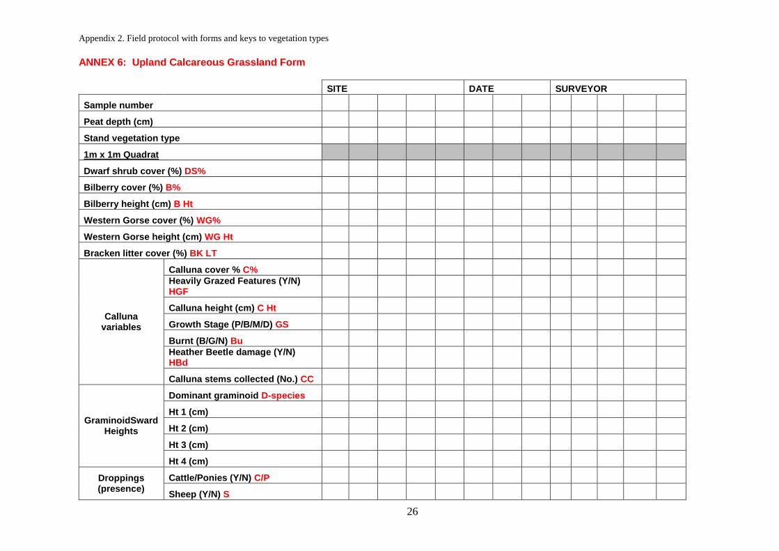
ANNEX 6: Upland Calcareous Grassland Form
SITE DATE SURVEYOR
Sample number
Peat depth (cm)
Stand vegetation type
1m x 1m Quadrat
Dwarf shrub cover (%) DS%
Bilberry cover (%) B%
Bilberry height (cm) B Ht
Western Gorse cover (%) WG%
Western Gorse height (cm) WG Ht
Bracken litter cover (%) BK LT
Calluna variables
Calluna cover % C%
Heavily Grazed Features (Y/N) HGF
Calluna height (cm) C Ht
Growth Stage (P/B/M/D) GS
Burnt (B/G/N) Bu
Heather Beetle damage (Y/N) HBd
Calluna stems collected (No.) CC
GraminoidSward Heights
Dominant graminoid D-species
Ht 1 (cm)
Ht 2 (cm)
Ht 3 (cm)
Ht 4 (cm)
Droppings (presence)
Cattle/Ponies (Y/N) C/P
Sheep (Y/N) S

Appendix 2. Field protocol with forms and keys to vegetation types
27
Other
Detached Calluna (No.) DC
Detached Vegetation (No.) DV
Bare ground (%) BG
1m x 1m Quadrat (presence)
Alpine Lady's-mantle Alchemilla alpina
Lady's-mantle Alchemilla glabra
Wild Angelica Angelica sylvestris
Mountain Everlasting Antennaria dioica
Thrift Armeria maritima
Squinancywort Asperula cynanchica
Quaking-grass Briza media
Harebell Campanula rotundifolia
Hair Sedge Carex capillaris
Spring Sedge Carex caryophyllea
Glaucous Sedge Carex flacca
Carnation Sedge Carex panicea
Flea Sedge Carex pulicaris
Carline Thistle Carlina vulgaris
Common Mouse-ear Cerastium fontanum
Lichen Cetraria islandica
Mountain Scurvy-grass Cochlearia alpina
Lichen Coelocaulon aculeatum
Heath Grass Danthonia decumbens
Hoary Whitlowgrass Draba incana

Appendix 2. Field protocol with forms and keys to vegetation types
28
Mountain Avens Dryas octopetala
Eyebright spp. Euphrasia spp.
Meadowsweet Filipendula ulmaria
Dropwort Filipendula vulgaris
Limestone Bedstraw Galium sterneri
Lady's Bedstraw Galium verum
Spring Gentian Gentiana verna
Gentian spp. Gentianella spp.
Water Avens Geum rivale
Hoary Rock-rose Helianthemum oelandicum
Common Rock-rose Helianthemum nummularium
Horseshoe Vetch Hippocrepis comosa
False Sedge Kobresia simpliciuscula
Crested Hair-grass Koeleria macrantha
Bitter-vetch Lathyrus linifolius
Rough Hawkbit Leontodon hispidus
Fairy Flax Linum catharticum
Common Bird's-foot-trefoil Lotus corniculatus
Spiked Wood-rush Luzula spicata
Alpine Forget-me-not Myosotis alpestris
Grass-of-Parnassus Parnassia palustris
Alpine Bistort Persicaria vivipara
Common Butterwort Pinguicula vulgaris
Sea Plantain Plantago maritima

Appendix 2. Field protocol with forms and keys to vegetation types
29
Bird's-eye Primrose Primula farinosa
Salad Burnet Sanguisorba minor
Yellow Saxifrage Saxifraga aizoides
Mossy Saxifrage Saxifraga hypnoides
Small Scabious Scabiosa columbaria
Lesser Clubmoss Selaginella selaginoides
Blue Moor-grass Seslaria caerulea
Betony Stachys officinalis
Devil's-bit Scabious Succisa pratensis
Wild Thyme Thymus polytrichus
Heath Speedwell Veronica officinalis
Cover of forbs (non-graminoids) (%)
Cover of graminoids (%)
Cover of non-native species (%)
Cover of Bracken (%)
Cover of scattered native trees and scrub (%)
Cover of Bellis perennis and/or Ranunculus repens (%)
Cover of -ve indicators and/or weeds (%)1
Cover of Soft Rush (%)
Percentage of tips of live leaves and/or flowering shoots of vascular plants > 5 cm tall (%)2
Percentage of tips of live leaves and/or flowering shoots of vascular plants < 5 cm tall (%)2
Less than 10% of grass and sedge tillers uprooted (Y/N)
Less than 10% of live leaves with signs of having been grazed for any of Alchemilla alpina, Nardus stricta, Prunella vulgaris, Thymus polytrichus (Y/N)

Appendix 2. Field protocol with forms and keys to vegetation types
30
Less than 50% of live of legumes or Plantago lanceolata with signs of having been grazed (Y/N)
Less than 66% of live leaves of grasses with signs of having been grazed (Y/N)
Less than 25% broken or uprooted of any of Huperzia selago, Saxifraga hypnoides, Selaginella selaginoides, Silene acaulis (Y/N)
More than 50% of the shoots of Dryas at least 3 cm long (Y/N)
More than 50% of leaves of Dryas at least 1.5 cm long (Y/N)
Percentage of ground cover for which dead plant litter forms a 'thatch' or 'felt' more than 2 cm in diameter (%)
2m x 2m Quadrat
Disturbed Bare Ground %3
Notes
Stand vegetation type Choose from Non-productive (NP), Montane heath (MH), Blanket bog (BB), Western heath (WSH), Wet heath (WEH), Heather heath
(HH), Flushes, fens & swamps (FFS), Bracken (BK), Fragmented heath (FH), Rough acid grassland (RAG), Bent/fescue acid grassland (BFG), Calcareous grassland (CG), Mesotrophic grassland, Improved grassland (IG) using 'Key to moorland vegetation types'
Dwarf shrub cover DS% Total cover of all dwarf shrubs except Vaccinium myrtillis. Include Calluna vulgaris, Erica spp., Empetrum nigrum, Ulex gallii and other
Vaccinium spp. If less than 1% record as 0.1%. Record as '0' if absent.
Bilberry height (cm) B Ht One height from centre of Bilberry block in quadrat. Leave blank if Bilberry absent.
Western Gorse height (cm) WG Ht One height from centre of Western Gorse block in quadrat. Leave blank if Western Gorse absent.
Heavily Grazed Features (Y/N) HGF Record if >/= 50% of the Calluna present shows growth forms indicative of heavy grazing (Y or N). Leave blank if Calluna
absent
Calluna height (cm) C Ht One height from centre of Calluna block in quadrat. Leave blank if Calluna absent.
Growth Stage GS Record the main age class of Calluna present (Pioneer 1-5 years, Building 6-15 years and Mature > 15 years). Leave blank if Calluna absent.
Burnt (B/G/N) Bu Record as ‘black’ ( c.12 months) or ‘grey’ (3-4 yrs) or not burnt. Leave blank if Calluna absent.
Heather Beetle damage (Y/N) HBd Record if Calluna within quadrat is showing signs of Heather Beetle damage. Leave blank if Calluna absent.
Calluna stems collected (No.) CC Record number of Calluna stems collected (0 - 4)
Graminoid Sward Heights Record dominant graminoid species (but exclude tall Juncus spp) and 4 height measurements from centre of quadrat quarters. Leave
blank if graminoids absent.
Detached Calluna (No.) DC Record number of detached Calluna stems. Record as '0' if none.
Appendix 2. Field protocol with forms and keys to vegetation types
31
Detached Vegetation (No.) DV Record number of detached vegetation (i.e. pulled stems, but do not include litter such as dead Molinia). If many (>20) guess to
nearest 10. Record as '0' if none.
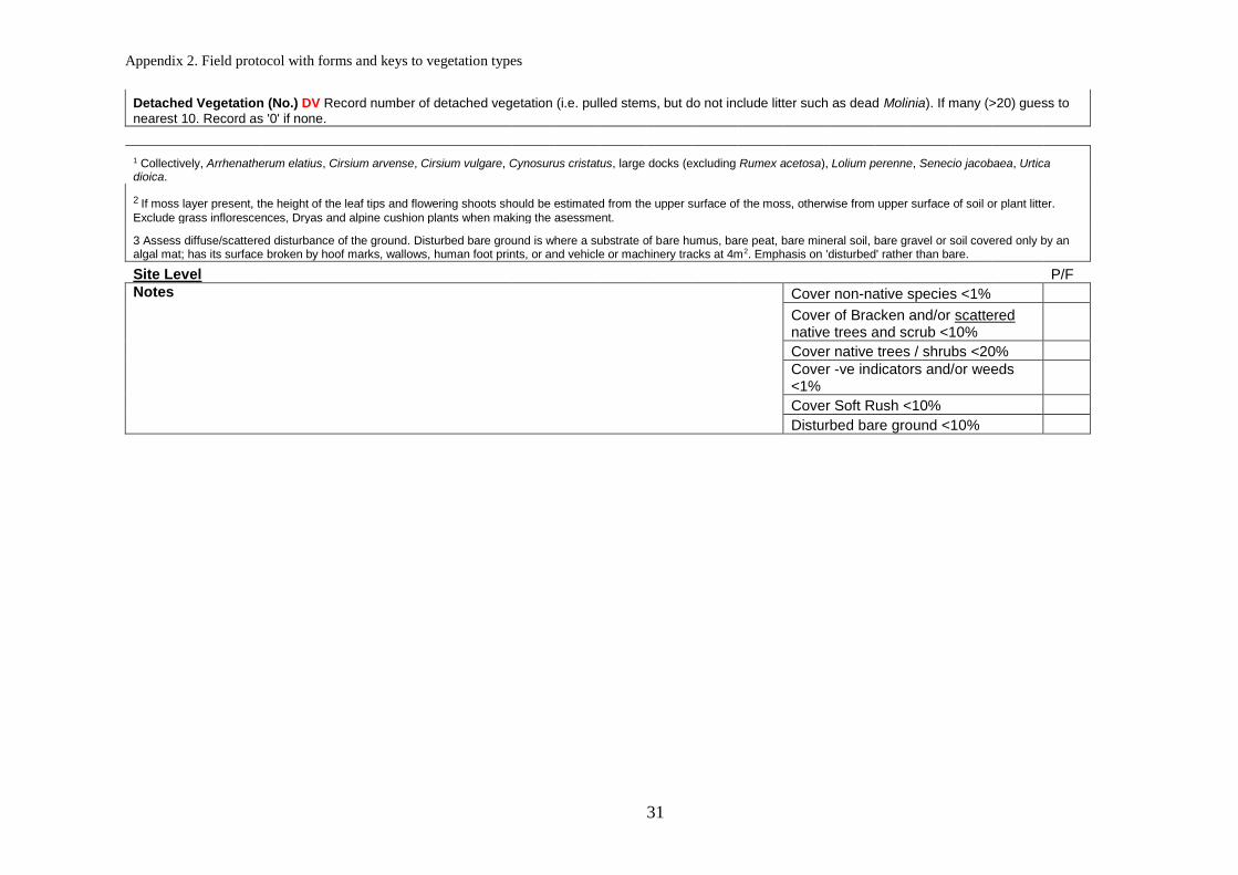
1 Collectively, Arrhenatherum elatius, Cirsium arvense, Cirsium vulgare, Cynosurus cristatus, large docks (excluding Rumex acetosa), Lolium perenne, Senecio jacobaea, Urtica dioica.
2 If moss layer present, the height of the leaf tips and flowering shoots should be estimated from the upper surface of the moss, otherwise from upper surface of soil or plant litter.
Exclude grass inflorescences, Dryas and alpine cushion plants when making the asessment.
3 Assess diffuse/scattered disturbance of the ground. Disturbed bare ground is where a substrate of bare humus, bare peat, bare mineral soil, bare gravel or soil covered only by an algal mat; has its surface broken by hoof marks, wallows, human foot prints, or and vehicle or machinery tracks at 4m2. Emphasis on 'disturbed' rather than bare.
Site Level P/F
Notes Cover non-native species <1%
Cover of Bracken and/or scattered native trees and scrub <10%
Cover native trees / shrubs <20%
Cover -ve indicators and/or weeds <1%
Cover Soft Rush <10%
Disturbed bare ground <10%

Appendix 2. Field protocol with forms and keys to vegetation types
32
ANNEX 7: Non-target Habitat Forms
SITE DATE SURVEYOR
Sample number
Peat depth (cm)
Stand vegetation type
1m x 1m Quadrat
Dwarf shrub cover (%) DS%
Bilberry cover (%) B%
Bilberry height (cm) B Ht
Western Gorse cover (%) WG%
Western Gorse height (cm) WG Ht
Bracken litter cover (%) BK LT
Calluna variables
Calluna cover % C%
Heavily Grazed Features (Y/N) HGF
Calluna height (cm) C Ht
Growth Stage (P/B/M/D) GS
Burnt (B/G/N) Bu
Heather Beetle damage (Y/N) HBd
Calluna stems collected (No.) CC
GraminoidSward Heights
Dominant graminoid D-species
Ht 1 (cm)
Ht 2 (cm)
Ht 3 (cm)
Ht 4 (cm)
Droppings (presence)
Cattle/Ponies (Y/N) C/P
Sheep (Y/N) S

Appendix 2. Field protocol with forms and keys to vegetation types
33
Other
Detached Calluna (No.) DC
Detached Vegetation (No.) DV
Bare ground (%) BG
Notes
Stand vegetation type Choose from Non-productive (NP), Montane heath (MH), Blanket bog (BB), Western heath (WSH), Wet heath (WEH), Heather heath
(HH), Flushes, fens & swamps (FFS), Bracken (BK), Fragmented heath (FH), Rough acid grassland (RAG), Bent/fescue acid grassland (BFG), Calcareous grassland (CG), Mesotrophic grassland, Improved grassland (IG) using 'Key to moorland vegetation types'
Dwarf shrub cover DS% Total cover of all dwarf shrubs except Vaccinium myrtillis. Include Calluna vulgaris, Erica spp., Empetrum nigrum, Ulex gallii and
other Vaccinium spp. If less than 1% record as 0.1%. Record as '0' if absent.
Bilberry height (cm) B Ht One height from centre of Bilberry block in quadrat. Leave blank if Bilberry absent.
Western Gorse height (cm) WG Ht One height from centre of Western Gorse block in quadrat. Leave blank if Western Gorse absent.
Heavily Grazed Features (Y/N) HGF Record if >/= 50% of the Calluna present shows growth forms indicative of heavy grazing (Y or N). Leave blank if Calluna absent
Calluna height (cm) C Ht One height from centre of Calluna block in quadrat. Leave blank if Calluna absent.
Growth Stage GS Record the main age class of Calluna present (Pioneer 1-5 years, Building 6-15 years and Mature > 15 years). Leave blank if Calluna
absent.
Burnt (B/G/N) Bu Record as ‘black’ ( c.12 months) or ‘grey’ (3-4 yrs) or not burnt. Leave blank if Calluna absent.
Heather Beetle damage (Y/N) HBd Record if Calluna within quadrat is showing signs of Heather Beetle damage. Leave blank if Calluna absent.
Calluna stems collected (No.) CC Record number of Calluna stems collected (0 - 4)
Graminoid Sward Heights Record dominant graminoid species (but exclude tall Juncus spp) and 4 height measurements from centre of quadrat quarters.
Leave blank if graminoids absent.
Detached Calluna (No.) DC Record number of detached Calluna stems. Record as '0' if none.
Detached Vegetation (No.) DV Record number of detached vegetation (i.e. pulled stems, but do not include litter such as dead Molinia). If many (>20) guess
to nearest 10. Record as '0' if none.