appendix 1 site screening - new york city
TRANSCRIPT
APPENDIX 1: SITE SCREENING
City Tunnel No. 3, Stage 2 Manhattan Leg Shaft 33B Final EIS Appendix 1-1
1.1 INTRODUCTION
As discussed in the Final Scope of Work and in Chapter 2, “Purpose and Need and Project Overview,” of this Environmental Impact Statement, the north leg of City Tunnel No. 3’s Stage 2 Manhattan leg will travel from Shaft 32B at Second Avenue near E. 35th Street to a terminus in East Midtown at Shaft 33B. While the specific location for this terminus depends on the suitability and feasibility of sites for Shaft 33B, there are certain locational requirements for the new Shaft.
Shaft 33B is intended to address the issues of water pressure and water supply in the portion of the Middle Intermediate Pressure Zone (MIPZ) east of Park Avenue, while adding flexibility and redundancy for the southeastern portion of the Northern Intermediate Pressure Zone (NIPZ). To meet this need, the shaft also must be located east of Park Avenue. The new Shaft would bring water from City Tunnel No. 3 to the primary trunk main for the eastern portions of the MIPZ and the NIPZ, which runs beneath Third Avenue.
Two new water mains would run from the regulators at Shaft 33B to the Third Avenue trunk main. Of the two new water mains that would connect Shaft 33B with the Third Avenue trunk main, one would supply water to the MIPZ and the other would supply water to the NIPZ. These mains would connect to the Third Avenue main on the south and north side of a new boundary valve between the two zones. Therefore, it is preferable to locate Shaft 33B in the general area of the boundary between those two zones.
Based on these requirements, the New York City Department of Environmental Protection (NYCDEP) identified and evaluated a number of sites in the vicinity of the northeastern portion of the MIPZ where Shaft 33B could be located.
1.2 SITE SCREENING PROCESS
A site screening process was undertaken to identify possible Shaft Sites in the general area where Shaft 33B must be located to meet its intended purpose. This is the general area within an acceptable distance from the boundary between the MIPZ and NIPZ at the Third Avenue trunk main. While Shaft 33B could be located at a greater distance from the connection point to the Third Avenue trunk main, the need to connect to that trunk main close to the boundary between the MIPZ and NIPZ would not change and therefore longer water main connections would be required. Given the greater disruption that would be required for these water main connections, NYCDEP restricted the review of available sites to those sites that are proximal to the northern portion of the MIPZ and the southern portion of the NIPZ.
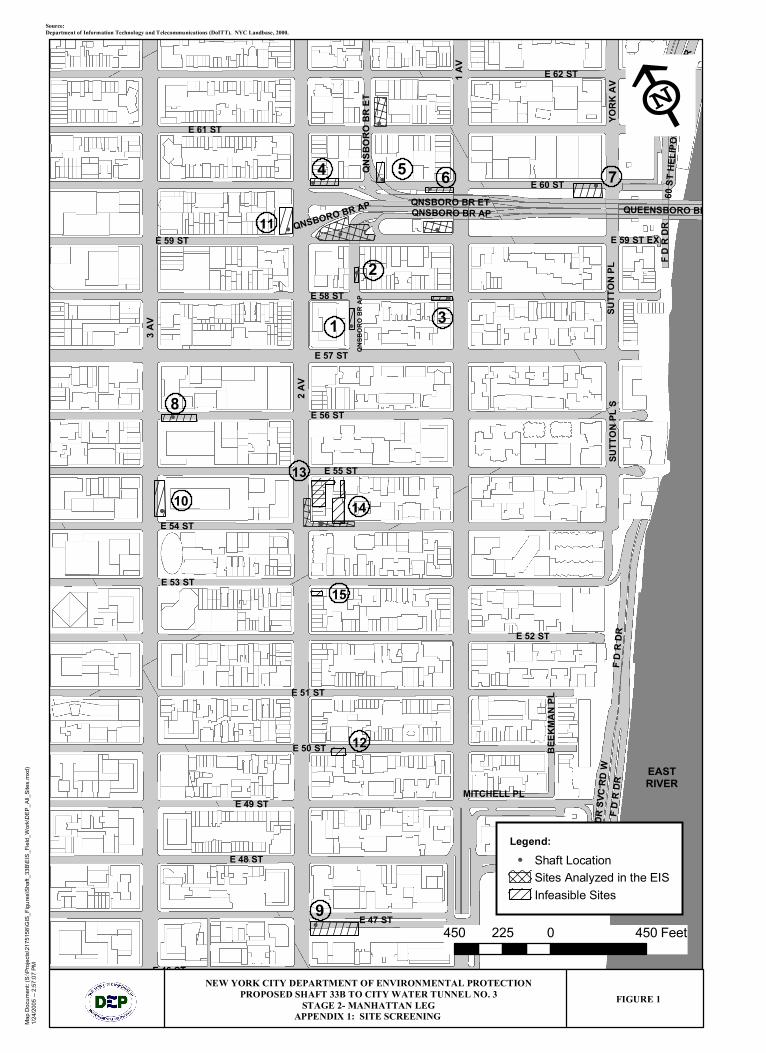
During this process, NYCDEP identified underutilized properties between E. 46th and E. 62nd Streets east of Third Avenue and evaluated them for their feasibility and suitability to serve as a Shaft Site. Nineteen locations were identified (see Figure 1) and each of these sites was

APPENDIX 1 SITE SELECTION
City Tunnel No. 3, Stage 2 Manhattan Leg Shaft 33B Final EIS Appendix 1-2
evaluated to determine whether construction of the shaft would be feasible at that location. Sites were determined to be infeasible if one of the following conditions applied:
• The site would require condemnation of active private property, other than surface parking lots or vacant lots.
• The site would require closing an entire street or avenue for construction of the shaft. • The site configuration would not accommodate the required space needed for construction of
the shaft. A minimum site width of at least 39 feet (assuming only minimal excavation support is required) and a length of 175 to 200 feet are necessary to accommodate shaft construction, as well as to provide room for maneuverability of equipment such as a crane. Vertical clearance is also required for the cranes that would be used during construction. (This minimum width assumes the presence of bedrock close to the surface; for sites where bedrock is deeper, more substantial support (a cofferdam) would be constructed around the distribution chamber, adding to the width required on the site.)
Based on the initial evaluation of each site, 15 sites were removed from further consideration for Shaft 33B.
1.3 ELIMINATED SITES
As discussed above, based on the initial site screening criteria, 15 sites were eliminated from further consideration. The reasons for site elimination are discussed in this section.
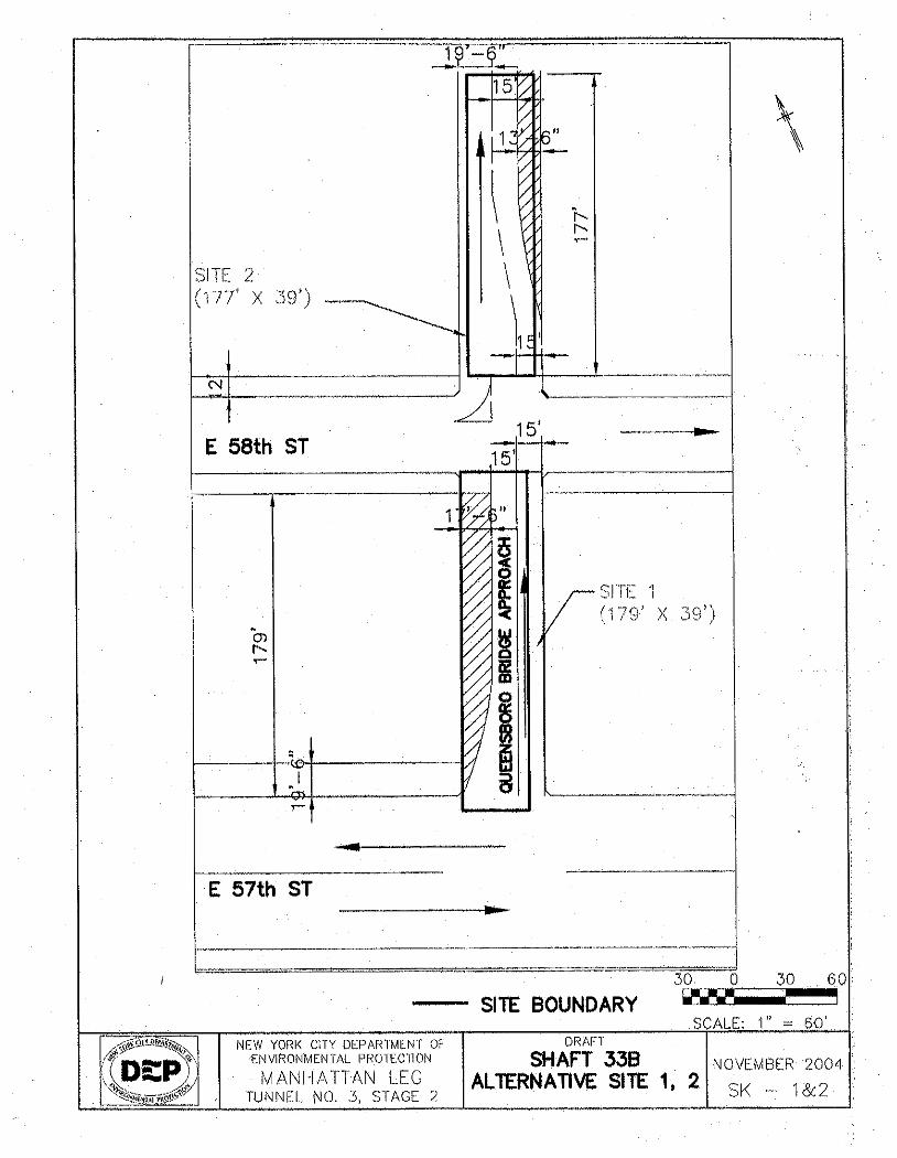
1.3.1 Queensboro Bridge Approach between E. 57th and E. 58th Streets (Site 1)
This site is a rectangular site located on the western side of the Queensboro Bridge Approach between E. 57th Street and E. 58th Street (Figure 1, Site 1 and Figure SK-1&2).
This site was not considered to be feasible because the 39-foot site width necessary for construction could not be achieved without the complete closure of the Queensboro Bridge Upper Level Approach and/or the condemnation of actively used private property. The Queensboro Bridge Upper Roadway Approach is 45 feet in width and does not have any sidewalks. In order to maintain a single lane of traffic, private property, including a multi-family residential structure adjacent and to the west of the site, would have to be acquired or condemned to widen the available area.
1.3.2 Queensboro Bridge Approach North of E. 58th Street
This site is a rectangular site located on the eastern side of the Queensboro Bridge Approach, north of E. 58th Street (Figure 1, Site 2 and Figure SK-1&2).
This site was not considered to be feasible because the 39-foot site width necessary for construction could not be achieved without the complete closure of the Queensboro Bridge Upper Level Approach. The Approach is 45 feet in width and does not have any sidewalks. In

APPENDIX 1 SITE SELECTION
City Tunnel No. 3, Stage 2 Manhattan Leg Shaft 33B Final EIS Appendix 1-3
order to maintain a single lane of traffic, private property, including an adjacent mixed-use residential/commercial building to the east of the site and an adjacent multi-family residential walk-up building to the west of the site, would have to be acquired or condemned to widen the available area.
1.3.3 E. 58th Street at First Avenue (Site 3)
This site is a rectangular site located on the eastern side of the E. 58th Street block between First and Second Avenues (Figure 1, Site 3 and Figure SK-3).
This site was not considered to be feasible because the 39-foot site width necessary for construction could not be achieved without the complete closure of E. 58th Street. The street is 34 feet wide and the sidewalks (including curbs) on the north and south are each 12.5 feet wide, or a total of 59 feet from the façade of the buildings on the north side of the E. 58th Street to the façade of the buildings on the south side of the street. Maintaining a traffic lane would require a total of 64 feet. Therefore, private property consisting of adjacent mixed-use (residential and commercial) buildings to the north and south of the site would have to be acquired or condemned on either side of E. 58th Street to widen the available area.
1.3.4 E. 60th Street at Second Avenue (Site 4)
This site is a rectangular site located on the western side of the E. 60th Street block between First
and Second Avenues (Figure 1, Site 4 and Figure SK-4).
This site was not considered to be feasible because the 39-foot site width necessary for construction could not be achieved without the complete closure of E. 60th Street. The street is 34 feet wide and the sidewalk (including the curb) on the north and south side of E. 60th Street are 13 feet and 10 feet, respectively, for a total of 57 feet. The Queensboro Bridge is located on the south side of the street. To maintain a single lane of traffic, a total of 64 feet would be needed. Therefore, private property, including an adjacent restaurant, mixed-use residential/commercial buildings, multi-family residential structures, and a commercial office building to the north of the site, would have to be acquired or condemned to widen the available area.
1.3.5 E. 60th Street between First and Second Avenues (Site 5)
This site is located on the north side of E. 60th Street on the east side of the exit ramp from the Lower Level of the Queensboro Bridge (Figure 1, Site 5). The site is directly underneath the Queensboro Bridge access ramp, and was not considered to be feasible because there is insufficient clearance between the lower girders of the access ramp and grade to allow movement of the cranes necessary for construction of the shaft.
APPENDIX 1 SITE SELECTION
City Tunnel No. 3, Stage 2 Manhattan Leg Shaft 33B Final EIS Appendix 1-4
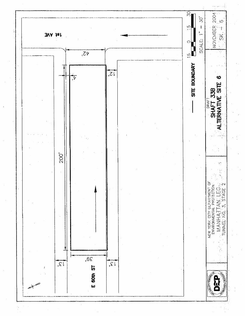
1.3.6 E. 60th Street at First Avenue (Site 6)
This site is a rectangular site located on the eastern side of the E. 60th Street block between First and Second Avenues (Figure 1, Site 6 and Figure SK-6).
This site was not considered to be feasible because the 39-foot site width necessary for construction could not be achieved without the complete closure of E. 60th Street. The street is 42 feet wide, and the sidewalks (including curbs) on the north and south are both 13 feet wide. The total width, from the façade of the buildings on the north side of the street to the Queensboro Bridge abutment on the south side of the street, is 68 feet. A bicycle lane, separated by a curb, also runs along the south side of the street. To maintain a single lane of traffic and accommodate a setback area from the bridge abutment, a total of 71 feet would be needed. Therefore, private property, including adjacent mixed-use residential/commercial buildings, would have to be acquired or condemned on the north side of E. 60th Street to widen the available area.
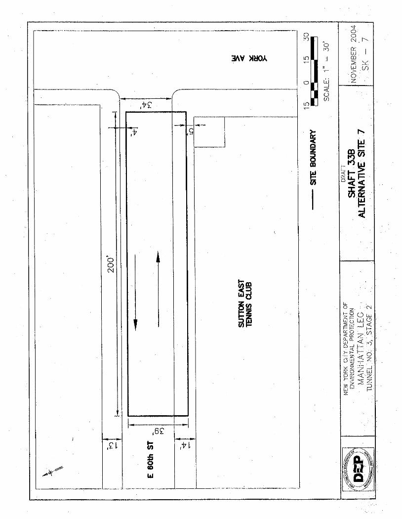
1.3.7 E. 60th Street at York Avenue (Site 7)
This site is a rectangular site located on the eastern side of the E. 60th Street block between First and York Avenues (Figure 1, Site 7 and Figure SK-7).
This site was not considered to be feasible as a shaft construction site either in the street or under the Queensboro Bridge. In the street, the 39-foot site width necessary for construction could not be achieved without the complete closure of E. 60th Street. The street is 34 feet wide, and the sidewalks (including curbs) on the north and south sides of E. 60th Street are 14 feet and 13 feet, respectively. The total width, from the façade of the buildings on the north side of the street to the façade of the buildings on the south side of the street, is 61 feet. In order to maintain a single lane of traffic, a total of 64 feet would be needed. Therefore, private property, including a parking garage on the north side of E. 60th Street, would have to be acquired or condemned in order to widen the available area. To build the shaft under the Queensboro Bridge, private property, including a private tennis facility, would have to be acquired or condemned.
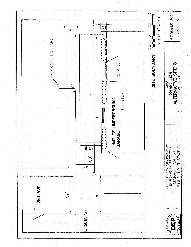
1.3.8 E. 56th Street at Third Avenue (Site 8)
This site is a rectangular site located on the western side of the E. 56th Street block between Second and Third Avenues (Figure 1, Site 8 and Figure SK-8).
This site was not considered to be feasible because the 39-foot site width necessary for construction would require the complete closure of E. 56th Street or acquisition of actively used private property, an underground parking garage. The total width from property line to property line across E. 56th Street is 60 feet. In order to maintain a single lane of traffic and continue to allow access to the parking garage on the north side of E. 56th Street, a total of 64 feet would be needed. Therefore, private property, including an adjacent underground parking garage, adjacent commercial office buildings, and adjacent residential structures, would have to be acquired or
APPENDIX 1 SITE SELECTION
City Tunnel No. 3, Stage 2 Manhattan Leg Shaft 33B Final EIS Appendix 1-5
condemned on the north and/or south sides of E. 56th Street in order to widen the available area. This is explained in more detail below.
The site screening evaluation made a number of preliminary assumptions regarding the available site area as follows:
1. A 20-foot travel zone would be maintained between the buildings on the north side of E. 56th Street and the Shaft Site. This travel zone would be occupied by a 5-foot-wide sidewalk and a 10-foot-wide travel lane for vehicles, as well as a 2.5-foot wide Jersey barrier between the sidewalk and the travel lane and another 2.5-foot Jersey barrier between the travel lane and the Shaft Site.
2. The site must be a minimum of 39 feet wide, which is the minimum width for a shaft construction zone with a single riser, assuming that the geological conditions are favorable (i.e., rock is just beneath the surface) and minimal excavation support would be required.
3. A minimum buffer zone of 7.5 feet must be provided between the southern edge of the shaft cofferdam and the northern extent of the subsurface structure underneath the plaza at 919 Third Avenue. The edge of this buffer zone coincides approximately with the northern edge of the surface planters, which are approximately 10 feet wide. Specifically, the area occupied by the public plaza serves as the roof of an underground parking garage for 919 Third Avenue. Based on field visits to the site and discussions with the building owner, project engineers concluded that the outside wall of the underground garage is located directly beneath the southern edge of the planters. An estimated 3 feet of additional structures would be expected beyond those outside walls in the northern direction (consisting of the wall thickness, the outer columns, and the necessary column footings), meaning that the edge of the underground foundation structures is beneath the planters, approximately 3 feet north of their southern edge.
Using these assumptions, and recognizing that total width of E. 56th Street is 60 feet from property line to property line, there is less than 1 foot of space remaining (20 feet for the road and sidewalk + 39 feet for the shaft site = 59 feet). This 1-foot gap, combined with the 7 feet available underneath the planters before contacting the subsurface garage structure, leaves a buffer zone of 8 feet. However, additional analysis during the screening process indicated that the 10-foot-wide travel lane for vehicles would not provide enough turning space for vehicular access to the parking garage located in the building immediately north of the site, on the north side of E. 56th Street. The minimum lane size necessary to provide access to the northern parking garage is 15 feet, and NYCDEP believes that even with 15 feet, vehicular access to the garage may be substantially affected. However, as discussed above, the site cannot be shifted southward because a buffer must be maintained between the shaft’s cofferdam wall and the edge of the underground garage structure at 919 Third Avenue. If the site were shifted an additional 5 feet (i.e., the minimum required to provide vehicular access to the northern garage), the 8-foot buffer zone provided would be reduced to only 3 feet of space. NYCDEP and its consultants deemed 3 feet too close for adjacent construction, as it would likely damage the underground garage and possibly the building foundation.
APPENDIX 1 SITE SELECTION
City Tunnel No. 3, Stage 2 Manhattan Leg Shaft 33B Final EIS Appendix 1-6
1.3.9 E. 47th Street at Second Avenue (Site 9)
This site is located near the Dag Hammarskjold Plaza on the southeast corner of the intersection of E. 47th Street and Second Avenue, near the United Nations. The New York City Police Department has indicated that development of this site would compromise access to a major emergency route for the United Nations. As a result, the site was not considered to be appropriate for a shaft construction (Figure 1, Site 9).
1.3.10 Third Avenue at E. 54th Street (Site 10)
This site is a rectangular site located on the east side of Third Avenue at E. 54th Street (Figure 1, Site 10 and Figure SK-10).
This site was not considered to be feasible because the 39-foot site width necessary for construction could not be achieved without extending into the street and affecting a maximum of four lanes on Third Avenue. Lane closure of this magnitude and for an extended period of time on an avenue would not be practical.
On the east side of Third Avenue, the distance from the edge of the building’s basement to the curb is approximately 15 feet. To accommodate the basement foundation footings, a 10-foot lane could not be utilized for construction. Therefore, the total width available on the east sidewalk is five feet. A total of 39 feet would be needed at this site to provide barriers between the construction area and pedestrians and traffic. Therefore, 35 feet would extend into Third Avenue, affecting the parking lane and at a minimum two traffic lanes (potentially three lanes).
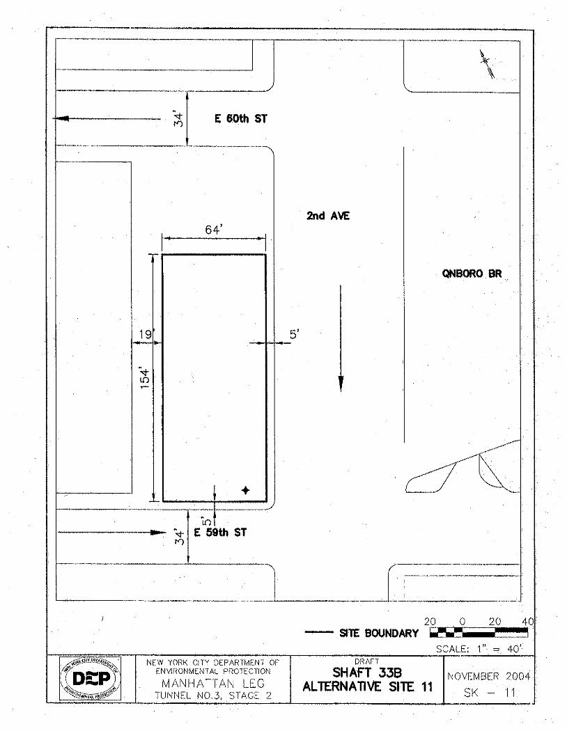
1.3.11 Second Avenue at E. 59th Street (Site 11)
This site is a rectangular site located on the northwest corner of the intersection of Second Avenue and E. 59th Street (Figure 1, Site 11 and Figure SK-11).
Although an acceptably sized and configured construction staging area could be achievable at this site, this site was determined not to be feasible because of the site’s proximity to an existing subway tube and because the location would interfere with the proposed Second Avenue Subway. Specifically, the shaft would have to be constructed adjacent to an existing subway tube (carrying the N and R lines) that runs beneath E. 60th Street to connect Queens and Manhattan. More importantly, in the future, construction of the proposed Second Avenue Subway would come in close proximity to the water supply shaft. This construction could compromise shaft integrity and would not be appropriate. In addition, vibration associated with drilling and blasting (or subway operation) adjacent to the riser piping could damage the piping or concrete refill.
Based on design information developed for the Second Avenue Subway during Preliminary Engineering, provided by MTA, the new subway will have four separate tubes passing beneath Second Avenue between E. 56th and E. 57th Streets. Two of these, directly beneath Second Avenue, will carry the north- and southbound Second Avenue Subway service. The other two,
APPENDIX 1 SITE SELECTION
City Tunnel No. 3, Stage 2 Manhattan Leg Shaft 33B Final EIS Appendix 1-7
beneath the blocks on the east and west sides of Second Avenue, will carry non-passenger trains between the Second Avenue alignment and Queens. These two outer tubes will curve from the 63rd Street Tunnel that passes below the East River between Second Avenue and Queens, and will join the regular Second Avenue Subway tunnels at approximately E. 56th Street. The western (southbound) of these two Queens tube alignments will pass directly beneath Tramway Plaza.
Site 11 is approximately 154 feet long along Second Avenue and approximately 88 feet deep between Second Avenue on the east to the building line on the west. According to Preliminary Engineering drawings for the Second Avenue Subway, the center line of the new Queens inbound tunnel for the subway will be approximately 30 feet north of the curbline. According to the Second Avenue Subway Final EIS, each subway tube will typically have a diameter of 21 to 23.5 feet. Conservatively using the smaller number, this means that the new subway tube will extend 10.5 feet from the track center line, so that the subway tube’s western edge will be approximately 40 feet west of the Second Avenue curbline beneath Tramway Plaza. This would bring the western edge of the subway tube to approximately 48 feet from the edge of the building line; i.e., a 48-foot-wide site would be available at Site 11 for a new water shaft. An accessway and buffer zone of a minimum of 7.5 feet must be provided between the building line and the Shaft Site, leaving a total site area at Tramway Plaza for Shaft 33B that is 40.5 feet wide. Shaft 33B would be 26 feet wide, with a minimum of 9 feet on either side to allow for a 4-foot work zone and 5 feet for the necessary excavation support systems. Placing the shaft as far west as possible, only 5.5 feet at most could therefore be provided between the edge of the shaft and the edge of the subway tunnel. In the opinion of the project engineers for Shaft 33B, this buffer area would be too small to guarantee the structural integrity of either the shaft or the subway. Please note that, according to the Second Avenue Subway Final EIS, the subway tubes themselves would generally be spaced so that the tunnel walls would be between 10 and 25 feet apart, indicating that at least 10 feet should be provided between the tube and an adjacent underground structure. Moreover, these dimensions are approximate and subject to revisions, since the Second Avenue Subway dimensions were obtained based on Preliminary Engineering, and since detailed plans for Shaft 33B at Tramway Plaza were not developed. As designs advance for both projects, the narrow buffer between the two underground structures could become still smaller.
1.3.12 Second Avenue at E. 50th Street (Site 12)
This site is a rectangular site located on the eastern side of the E. 50th Street block between First and Second Avenues (Figure 1, Site 12).
This site was not considered to be feasible because the 39-foot site width necessary for construction could not be achieved without the complete closure of E. 50th Street. The street is 34 feet wide and the sidewalk (including curbs) on the north is 13 feet wide, and the sidewalk on the south is 13 feet wide, for a total of 60 feet from the façade of the buildings on the north side of the E. 50th Street to the façade of the buildings on the south side of the street. Maintaining a traffic lane would require a total of 64 feet. Therefore, private property consisting of adjacent mixed use residential/commercial buildings to the north and south of the site would have to be acquired or condemned on either side of E. 50th Street in order to widen the available area.
APPENDIX 1 SITE SELECTION
City Tunnel No. 3, Stage 2 Manhattan Leg Shaft 33B Final EIS Appendix 1-8
1.3.13 Second Avenue at E. 55th Street (Site 13)
The site is a rectangular site located on the southeast corner of E. 55th Street and Second Avenue. NYCDEP identified this privately held undeveloped site as a feasible site for shaft construction. The site was subsequently acquired by a private developer and was then developed with the recently completed Milan Condominiums (Figure 1, Site 13).
1.3.14 E. 54th and E. 55th Streets East of Second Avenue (Site 14)
The site is a rectangular site located between E. 54th Street and E. 55th Street just east of Second Avenue. NYCDEP identified this privately held undeveloped site as a feasible site for shaft construction. However, the site was acquired by a developer and construction of the appurtenant structures including a parking garage associated with the Milan Condominiums has recently been completed (Figure 1, Site 14).
1.3.15 Second Avenue at E. 53rd Street (Site 15)
The site is a rectangular site located on the southeast corner of E. 53rd Street and Second Avenue. In 2000, NYCDEP identified this privately held undeveloped lot as a feasible site for Shaft construction. The site was subsequently privately acquired and is currently being developed with a high-rise residential building (Figure 1, Site 15).
1.4 POTENTIAL SHAFT SITES
Four sites were considered to be potentially feasible locations for the proposed Shaft 33B, as follows:
• E. 59th Street and First Avenue; • E. 59th Street and Second Avenue; • E. 61st Street between First and Second Avenue; and • E. 54th Street and Second Avenue.
These sites are analyzed throughout the Environmental Impact Statement.
!
!!
!!
!
!
!
!
!
!
!
!
!
!
!
!
QNSB
ORO
BR A
P
3 AV
2 AV
1 AV
E 62 ST
E 60 ST
E 61 ST
E 56 ST
E 55 ST
E 57 ST
E 59 ST
E 58 ST
E 54 ST
E 52 ST
E 53 ST
E 49 ST
E 50 ST
E 51 ST
E 47 ST
E 46 ST
E 48 ST
F D R
DR
QUEENSBORO BRQNSBORO BR AP
YORK
AV
SUTT
ON PL
S
FDR DR EN NB
SUTT
ON PL
QNSBORO BR ET
FDR
DR W
LA
MITCHELL PL
60 S
T HEL
IPOR
T RP
E 59 ST EX
BEEK
MAN
PL
FDR
DR SV
C RD
W
QUEENSBORO BRQNSBORO BR AP
F D R
DR
F D R
DR
QNSB
ORO
BR E
T
F D R
DR
Source:Department of Information Technology and Telecommunications (DoITT). NYC Landbase, 2000.
Map D
ocum
ent: (
S:\Pr
ojects
\2175
158\G
IS_Fig
ures\S
haft_
33B\E
IS_F
ield_
Work
\DEP
_All_
Sites
.mxd
)1/2
4/200
5 -- 2
:57:07
PM
EASTRIVER
E
Legend:! Shaft Location
Sites Analyzed in the EISInfeasible Sites
NEW YORK CITY DEPARTMENT OF ENVIRONMENTAL PROTECTIONPROPOSED SHAFT 33B TO CITY WATER TUNNEL NO. 3
STAGE 2- MANHATTAN LEGAPPENDIX 1: SITE SCREENING
FIGURE 1
450 0 450225 Feet
54
11
6 7
2
1 3
8
9
10
12
13
15
14