appendix 1 (digital) - forestry commission · upland & podzolic brown eart ironpan peaty...
TRANSCRIPT

Dartmoor Forest Plan
2016 - 2026
Page 33
Geology
LegendSuperficial
CLAY, SILT, SAND AND GRAVEL
GRAVEL
PEAT
SAND AND GRAVEL
Bedrock
GRANITE
MICROGRANITE
METAMUDSTONE AND METASANDSTONE
The geology across the four
forests is of the distinctive
Dartmoor granite intrusion with
minor silt and sand deposits along
riparian areas and peat in the
more upland regions.
00
.61
.21
.82.
40
.3M
iles
© C
row
n c
op
yri
gh
t a
nd
da
tab
ase
rig
ht
[20
16
] O
rdn
an
ce S
urv
ey
[1
00
02
12
42
]

Dartmoor Forest Plan
2016 - 2026
Page 34
Soils
Legend
Open water
Upland & Podzolic brown eart
Ironpan
Peaty surface-water gley
Calluna bog
The soils tend to be acid, but
reasonably fertile where drainage is
good. However drainage is impeded
over much of the forest due to a layer
of reddish/brown clay which occurs at
a depth of between 1 and 2 metres,
with peat forming above this.
Therefore much is of the peaty
podzolic type with a tendency to form
an ironpan and gley. Brimpts is
slightly different in character with
fairly fertile and freely draining upland
brown earths which are undermined
by a stony scree substrate.
© C
row
n c
op
yri
gh
t a
nd
da
tab
ase
rig
ht
[20
16
] O
rdn
an
ce S
urv
ey
[1
00
02
12
42
] 0
0.6
1.2
1.8
2.4
0.3
Mile
s

Dartmoor Forest Plan
2016 - 2026
Page 35
Landform
Lines of upward force (valleys and hollows)
Lines of downward force
(ridges and plateaus)
The Dartmoor Plan area sits in an
upland moorland landscape at
between 250 - 500 metres above sea
level
The landscape analysis is used to
assess the landform patterns and
demonstrates how it is in keeping
with the surrounding landscape
character.
One’s eye is naturally drawn up the
valleys and down the ridges. These
principles will be used to design the
shape of future coupes. Ensuring that
the shape and size of felling and
restocking areas do not detract from
the natural appearance of the forest
and its contribution to the landscape
character.
© Crown copyright and database right [2016] Ordnance Survey [100021242]
0 0.6 1.2 1.8 2.40.3Miles

Dartmoor Forest Plan
2016 - 2026
Page 36
Panorama 1 Fernworthy South East
Landscape Analysis
The proposed felling and restocking of coupes has been
analysed from a number of significant viewpoints.
These viewpoints have been identified because of the
amount of foot and vehicle traffic they experience and
the influence the forest has at these locations. Given
the nature of the landscape on Dartmoor, there are
minimal settlements from which the Forest Plan area
can be seen. The B3212 and B3357 are popular tourist
routes and two of the main arterial roads across the
moor. Therefore the majority landscape analyses have
been done along highpoints of these roads. The views
from the popular walking destination of Bellever Tor
has also been analysed given its comprehensive views
of the surrounding landscape.
© C
row
n c
op
yri
gh
t a
nd
da
tab
ase
rig
ht
[20
16
]
Ord
na
nce
Su
rve
y [
10
00
21
24
2]
0 0.45 0.9 1.35 1.80.225Miles
Legend
View Shed AnalysisVisible from Panorama 2
Visible from Panorama 3
Visible from Panorama 6
Coupe 82661 is in an elevated position and is clearly
visible from a distance. The felling will see the removal
of a large proportion of the cover, with fringes retained
and the diffuse edge creation (10ha) the landscape
impact will be addressed.
Coupes 82337 & 82406 are visible from
a distance and interlock well with the
landscape. Diffuse edge creation would be
unsuitable here given the distance.
Panorama 1 - 2026 Impression (showing planned coupe clearfells)

Dartmoor Forest Plan
2016 - 2026
Page 37
Panorama 2 Fernworthy South West
Coupe 82661 is in an elevated position and is clearly
visible from a distance. The felling will see the removal
of a large proportion of the cover, with fringes retained
and the diffuse edge creation (10ha) the landscape
impact will be addressed.
Coupe 82796 sits exposed in the
landscape due to delay in felling. The
Creation of the diffuse edge (6.5ha)
will address future landscape impact.
Panorama 3
Soussons West
Coupe 82748 sits low in the landscape at this popular tourist stop-
off, with established crops behind to ensure the visual landscape is
not compromised. The creation of open space for heritage
restoration will make a contribution to the cultural landscape.
Panorama 4
Soussons South
Coupe 82539 appears at an angle and falls behind
the hill. The staged clearfelling of this exposed edge
together with progressive additional amenity planting
will limit the impact on the landscape.
Coupe 82748 sits low in the
landscape and at a distance when
viewed from the south.
Panorama 2 - 2026 Impression (showing planned coupe clearfells)
Landscape Analysis 2
Panorama 3 - 2026 Impression (showing planned coupe clearfells)
Dartmoor Forest Plan
2016 - 2026
Page 38
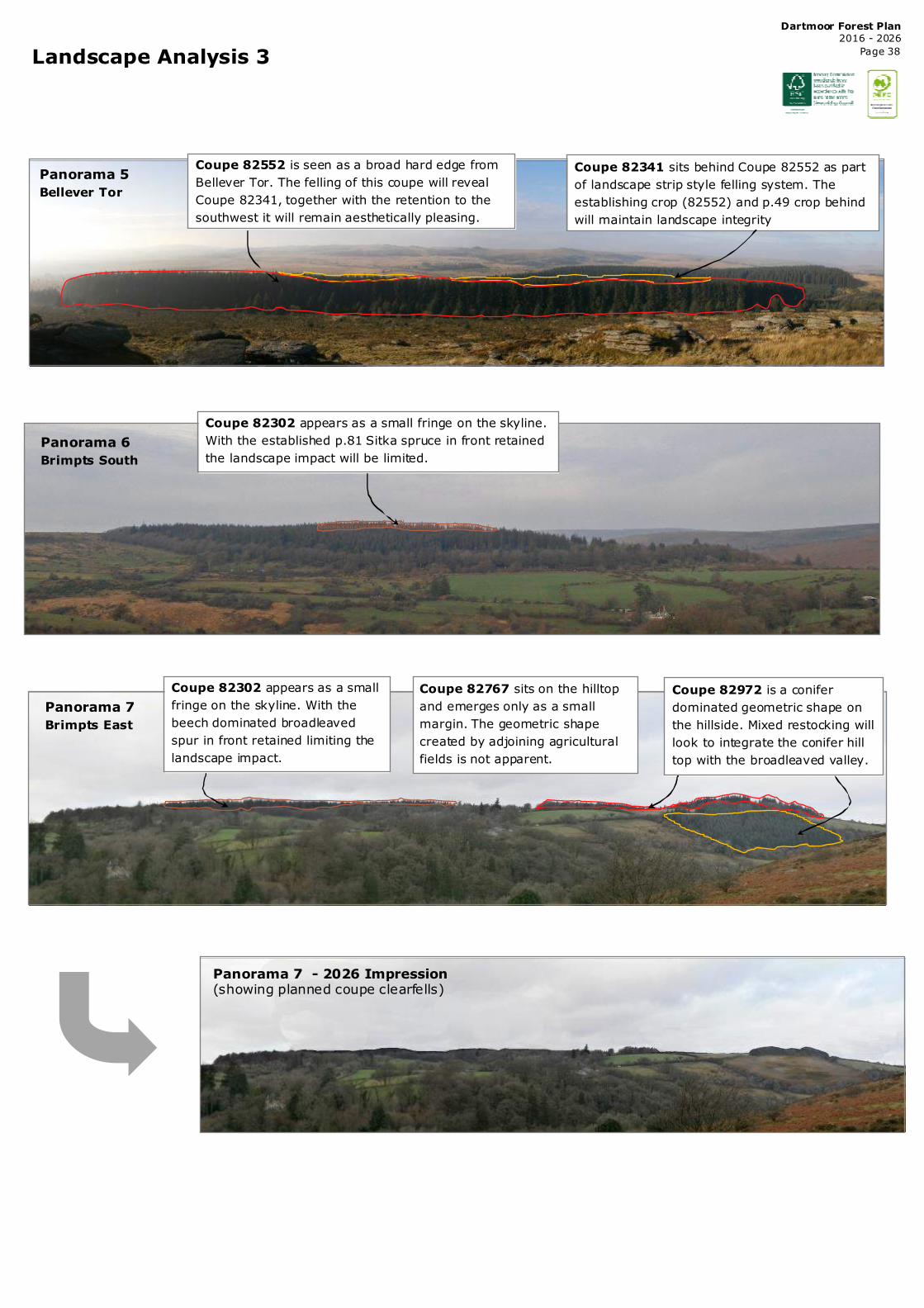
Landscape Analysis 3
Panorama 6
Brimpts South
Panorama 5
Bellever Tor
Coupe 82302 appears as a small fringe on the skyline.
With the established p.81 Sitka spruce in front retained
the landscape impact will be limited.
Panorama 7
Brimpts East
Coupe 82302 appears as a small
fringe on the skyline. With the
beech dominated broadleaved
spur in front retained limiting the
landscape impact.
Coupe 82972 is a conifer
dominated geometric shape on
the hillside. Mixed restocking will
look to integrate the conifer hill
top with the broadleaved valley.
Coupe 82767 sits on the hilltop
and emerges only as a small
margin. The geometric shape
created by adjoining agricultural
fields is not apparent.
Coupe 82552 is seen as a broad hard edge from
Bellever Tor. The felling of this coupe will reveal
Coupe 82341, together with the retention to the
southwest it will remain aesthetically pleasing.
Coupe 82341 sits behind Coupe 82552 as part
of landscape strip style felling system. The
establishing crop (82552) and p.49 crop behind
will maintain landscape integrity
Panorama 7 - 2026 Impression (showing planned coupe clearfells)

Dartmoor Forest Plan
2016 - 2026
Page 39
South Devon Basin
The South Devon Basin covers the catchments of the Rivers Teign,
Dart, Erme and Avon, which flow east and south from Dartmoor
into the estuaries and sea. The area is environmentally rich,
containing several important environmental sites and a very high
quality river system.
The South Devon Basin covers an areas of some 1,500 square
kilometres (580 square miles). The main physical characteristics of
the catchments are steeply sloping watercourses rising in the
Dartmoor National Park, that then flow into wider, more permeable
valleys in the lower reaches. Annual rainfall ranges from more than
2,300mm (90in) in upland areas to less than 1,000mm (39in) on
the coast. The England and Wales average is 920mm (36in).
There are 113 river water bodies in the catchment, with a
combined length of almost 700 km, and 10 lakes. Currently, 43
per cent of surface waters (199 km or 29 per cent of river length
and 5 of the lakes) achieve good or better ecological status/
potential. Waters at good ecological status now include the
Harbourne River and the Ugbrooke Stream. The main reasons for
less than good status are, in order, impacted fish communities, low
pH, impacted diatom communities and high levels of copper and
phosphate. 49 per cent of surface waters assessed for biology are
at good or high biological status now.
Legend
River Type
Primary River
Secondary Rive r
Tertiary R iver
Water Management
FLOW
South West Catchment District
Just over 3 million people live in the South West River Basin
District. The economy is dominated by the service sector, and
each year millions of visitors to the district make a vital
contribution to the economy. However, the resulting seasonal
fluctuations in population bring challenges for protecting the
water environment, especially in coastal areas.
The district has a huge network of internationally, nationally
and locally recognised wildlife sites, from the uplands of
Dartmoor and Exmoor and outstanding rivers such as the
Camel and Hampshire Avon, to the fantastic estuaries and
coastline. There are two national parks, and the Jurassic Coast
in Devon and Dorset is the only natural world heritage site in
England.
The farming and land management sector has a big role in
looking after and improving the quality of the rural
environment. Agriculture accounts for approximately three
quarters of the land area in the South West River Basin District.
Riparian Management
The riparian zones (14ha) identified will be developed over time to
create and maintain areas of upto 50% continuous forest cover
through gradual regeneration or enrichment with site appropriate tree
species, such as Alnus, Salix and Ulmus spp. A gradual change to this
type of wet woodland habitat will create a environment of dappled
shade with good light penetration and aeration as well as buffer the
riverine systems from forestry operations.
Clearfells within the area have been designed and phased to minimise
surface water runoff
and soil erosion
ensuring the riverine
systems and SSSI
are protected and
improved into the
future. All operations
will look to work
within the guidelines
set out in UKFS,
Forests and Water.
The Dartmoor forests
provides excellent
flood alleviation for
the Dart and Teign
and the wider South
Devon Catchment
through soil
stabilisation and
surface runoff,
retaining forest cover
and a move towards
continuous cover
systems together
with maintained
drains and water
storage will ensure
this continues to
slow down peak
flows into the future.
Current Status
High
Good
Moderate
Bad
Poor
Critical Load Area
The Dartmoor forests sit entirely within a high impact critical
load area. As a result felling will be phased and co-ordinated
with consideration given to minimising residues, whole tree
harvesting, stump removal and short rotation forestry.
0 0.45 0.9 1.35 1.80.225Miles
Riparian areas
© Crown copyright and database right [2016]
Ordnance Survey [100021242]
0 0.45 0.9 1.35 1.80.225Miles
© Crown copyright and database right [2016]
Ordnance Survey [100021242]

Dartmoor Forest Plan
2016 - 2026
Page 40
Wildfire Resilience
Legend
Recreation Trail
Recreation Area
Thicket Stage Crops
Internal Heathland/Felled Areas
Surrounding Heathland
Fire Risk
Wildfires are relatively rare however their impacts can be disproportionately large
and costly to society and their frequency are predicted to increase due to
increased land pressure and climate change. Young coniferous woodland of pine,
spruce or fir are at particularly high-risk from wildfire as are dwarf shrub heath,
gorse, bracken and grasses. This makes the Dartmoor Plan area at specific risk
due to both the nature of the tree crops, the planned management in future
decades and the significant amount of heath grassland which surrounds it.
The vast majority of wildfires are caused by people, accidentally or deliberately.
The risk of this is increased by periods of dry hot weather. The nature of the site,
its topography, land use and vegetation type as well as tree health and wind all
determine the ferocity and extent of a fire.
The Dartmoor Plan area does experience periods of high visitor numbers,
particularly in Bellever. The National Park as a ‘wild’ visitor destination does
mean that whilst prohibited camping and camp fires do occur within the Plan area.
Therefore sites close to car parks and popular trails are at greatest risk of
experiencing the initiation of a fire event.
Crop Stage Risk
Mitigation and Management
Mitigation of wildfire risk can be achieved by managing vegetation and fuels,
creating fire breaks and belts, improving forest design and silvicultural diversity
and the management and education of people. The key principles outlined here
follow the FC Practice Guide (2014).
Vegetation will be managed as part of standard forest operations and
maintenance. Fire breaks have been identified and located at critical locations
such as at the bottom of slopes and in conjunction with other fire resistance liner
features, such as roads, rides and rivers. Fire belts already exist in places and
predominantly consist of fire retardant broadleaves. The criteria for location and
extent of these is much the same for fire breaks and they offer an alternative to
these forms of wildfire mitigation
Management Regimes
Clearance of windthrow and deadwood in high risk areas as well as remaining
wood residues and products will contribute to lowering the fuel load factor and
minimising the risk of ladder fires.
Education as well as provision of practical information are the key factor to
wildfire mitigation, this will be focused around areas of highest recreational
footfall. Vegetation management around key recreation sites, notably Bellever car
park and along well used trails will lower the fuel load factor and thus the risk of
fire ignition. Provision of robust retardant facilities are also key to limiting fire
ignition and spread.
Legend
Fire_BreaksFire Bel t
Fire Break
Road/Ride
Fire Zones
Management
Prac�ce
Zone A - Asset Zone
Protect human life &
infrastructure
Zone B - Buffer Zone
A buffer areas around
Zone A
Zone C - Low-risk
Low to medium risk area
for normal management
Zone D -Fire excl. Zone
Protect habitats and
heritage
Vegeta�on
management
Vegeta*on and other
combus*ble materials
should be minimised
Fuel loading and
deadwood should be
reduced
Conven*onal vegeta*on management prac*ces
Fire Belt 30-40 metres 20 metres
Fire Break 3 x vegeta*on height 1 x vegeta*on height 1 x vegeta*on height 3 x vegeta*on height
20 metres 20 metres
Fire ZonesZone A - Asset Zone
Zone B - Buffer Zone
Zone C - Low-risk Zone
Zone D - Fire exclusion Zone
Stage Likelihood of
surface fire
Likelkihood of
crown fire
Likelihood of
ladder fire
New Plan�ng M N/A N/A
Pre-thin H H H
Post-thin L L L
Fell & Restock M N/A N/A 0 0.45 0.9 1.35 1.80.225
Miles
0 0.45 0.9 1.35 1.80 .225Miles
© Crown copyright and database right [2016] Ordnance Survey [100021242]