antarctic map folio seriescommittee on antarctic names (acan), which makes recommendations on...
TRANSCRIPT
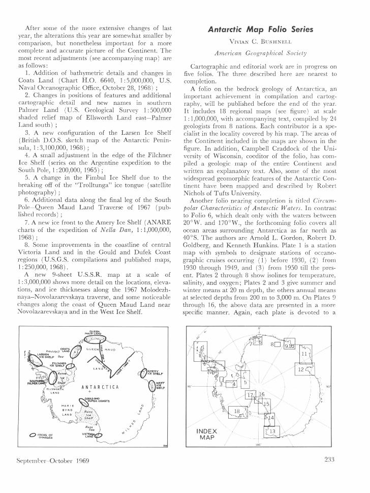
After some of the more extensive changes of lastyear, the alterations this year are somewhat smaller bycomparison, but nonetheless important for a morecomplete and accurate picture of the Continent. Themost recent adjustments (see accompanying map) areas follows:
1. Addition of bathymetric details and changes inCoats Land (Chart H.O. 6640, 1:5,000,000, U.S.Naval Oceanographic Office, October 28, 1968)
2. Changes in positions of features and additionalcartographic detail and new names in southernPalmer Land (U.S. Geological Survey 1:500,000shaded relief map of Ellsworth Land east—PalmerLand south)
3. A new configuration of the Larsen Ice Shelf(British D.O.S. sketch map of the Antarctic Penin-sula, 1:3,100,000, 1968);
4. A small adjustment in the edge of the FilchnerIce Shelf (series on the Argentine expedition to theSouth Pole, 1:200,000, 1965)
5. A change in the Fimbul Ice Shelf due to thebreaking off of the "Trolitunga" ice tongue (satellitephotography);
6. Additional data along the final leg of the SouthPole—Queen Maud Land Traverse of 1967 (pub-lished records)
7. A new ice front to the Amery Ice Shelf (ANAREcharts of the expedition of Nella Dan, 1: 1,000,000,1968);
8. Some improvements in the coastline of centralVictoria Land and in the Gould and Dufek Coastregions (U.S.G.S. compilations and published maps,1:250,000 1 1968).
A new 9-sheet U.S.S.R. map at a scale of1:3,000,000 shows more detail on the locations, eleva-tions, and ice thicknesses along the 1967 Molodezh-naya—Novolazarevskaya traverse, and some noticeablechanges along the coast of Queen Maud Land nearNovo lazarevskaya and in the West Ice Shelf.
LARSENICE SHELF SeO
LLSWOR ANTARCTICALAND +
11 GOULD ANDOUFEK COASTS
MARIE
flossLAND
Shs!f
-ROSDsea
AREAS OF LANCHANGES
September—October 1969
Antarctic Map Folio SeriesVIVIAN C. BUSHNELl.
American Geographical Society
Cartographic and editorial work are in progress onfive folios. The three described here are nearest tocompletion.
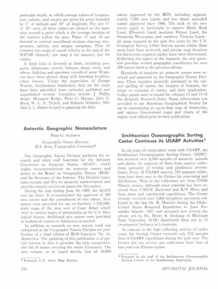
A folio on the bedrock geology of Antarctica, animportant achievement in compilation and cartog-raphy, will be published before the end of the year.It includes 18 regional maps (see figure) at scale1: 1,000,000, with accompanying text, compiled by 24geologists from 8 nations. Each contributor is a spe-cialist in the locality covered by his map. The areas ofthe Continent included in the maps are shown in thefigure. In addition, Campbell Craddock of the Uni-versity of Wisconsin, coeditor of the folio, has com-piled a geologic map of the entire Continent andwritten an explanatory text. Also, some of the mostwidespread geomorphic features of the Antarctic Con-tinent have been mapped and described by RobertNichols of Tufts University.
Another folio nearing completion is titled Circum-polar Characteristics of Antarctic Waters. In contrastto Folio 6, which dealt only with the waters between20°W. and 170°W., the forthcoming folio covers allocean areas surrounding Antarctica as far north as40°S. The authors are Arnold L. Gordon. Robert D.Goldberg, and Kenneth Hunkins. Plate 1 is a stationmap with symbols to designate stations of oceano-graphic cruises occurring (1) before 1930, (2) from1930 through 1949, and (3) from 1950 till the pres-ent. Plates 2 through 8 show isolines for temperature,salinity, and oxygen; Plates 2 and 3 give summer andwinter means at 20 m depth, the others annual meansat selected depths from 200 m to 3,000 m. On Plates 9through 16, the above data are presented in a morespecific manner. Again, each plate is devoted to a
233
particular depth, at which average values of tempera-ture, salinity, and oxygen are given for areas boundedby 50 of latitude and 100 of longitude. For any 50X 10 area, all three values are plotted on the samemap around a point which is the average location ofthe stations within the area. Plates 17 and 18 aredevoted to vertical meridional sections showing tem-perature, salinity, and oxygen variations. Plate 19contains two maps of sound velocity in the axis of theSOFAR channel; one map is for summer, one forwinter.
A third folio is devoted to birds, including pen-guins, albatrosses, petrels, fulmars, skuas, terns, andothers. Sighting and specimen records of some 50 spe-cies have been plotted along with breeding localities,when known. Under the supervision of GeorgeWatson, Smithsonian Institution, data for the mapshave been assembled from extensive published andunpublished records. Compilers include J . PhillipAngle, Margaret Bridge, Peter C. Harper, John C.Boyd, W. L. N. Tickell, and Roberto Schlatter. Wil-liam J . L. Sladen helped in planning the folio.
Antarctic Geographic NomenclatureFRED G. ALBERTS
Geographic Names DivisionU.S. Army Topographic Command*
The Geographic Names Division performs the re-search and other staff functions for the AdvisoryCommittee on Antarctic Names (ACAN), whichmakes recommendations on antarctic names andpolicy to the Board on Geographic Names (BGN)and the Secretary of the Interior. The Division main-tains records and files on antarctic nomenclature andprovides inquiry service on names for this region.
During the year ending June 30, 1969, the ACANmet six times. It recommended the approval of 369new names and the amendment of two others. Newnames were provided for use on fourteen 1:250,000-scale maps of the area west of Cape Adare whichwere in various stages of preparation at the U.S. Geo-logical Survey. Additional new names were providedto authors of reports on Antarctica as needed.
In addition to research on new names, work wascompleted at the Geographic Names Division for pub-lication of a third edition of BGN Gazetteer No. 141Antarctica. The updating of this publication is of spe-cial interest in that it provides the only comprehen-sive list of names covering the entire Continent. Thenew volume, to be issued shortly, lists all 10,000
* Formerly U.S. Army Map Service.
names approved by the BGN, including approxi-mately 1,500 new names and two dozen amendednames approved since 1966. The bulk of the newnames apply to landmarks in eastern Marie ByrdLand, Ellsworth Land, southern Palmer Land, thePensacola Mountains, and northern Victoria Land—all areas mapped in the past few years by the U.S.Geological Survey. Older feature names within theseareas have been reviewed, and precise map locationsfor discoveries reported earlier have been determined.Reflecting this aspect of the research, the new gazet-teer provides revised geographic coordinates for over500 names listed in the previous edition.
Hundreds of inquiries on antarctic names were re-ceived and answered by the Geographic Names Divi-sion. These inquiries generally pertained to the cor-rect spelling of names, the location of features, theorigin or meaning of names, and their application.Galley proofs were reviewed for volumes 13 and 14 ofthe Antarctic Research Series. Name information wasprovided to the American Geographical Society foruse in maintaining an up-to-date map of Antarctica,and various Government maps and charts of theregion were edited prior to their publication.
Smithsonian Oceanographic SortingCenter Continues its USARP Activities*
In six years of cooperative work with USARP, theSmithsonian Oceanographic Sorting Center (SOSC)has received over 8,000 samples of antarctic animalsand plants, the majority of them from marine collec-tions, primarily of benthic and planktonic inverte-brates. From 16 USARP sources, 183 separate collec-tions have been sent to the Center for processing anddistribution. Most of the collections are from USNSEltanin cruises, although some material has been re-ceived from USCGC Eastwind and R/V Hero, andfrom shore and continental expeditions. The Centerrecently received over 1,000 bryophyte specimens col-lected by the late Dr. R. Hatcher during the Chile—United States Botanical Expedition to Juan Fer-nández Islands-1965 and arranged into several du-plicate sets by Dr. Henry A. Imshaug of MichiganState University. SOSC distributed these sets to 11cryptogamic herbaria in 5 countries.
In contrast to the high collecting activity of earlieryears, the Sorting Center received only 232 samplesfrom 6 USARP expeditions during the past year. TheCenter did not receive any collections from four oflast year's six Eltanin cruises.
* Prepared by the staff of the Smithsonian OceanographicSorting Center of the Smithsonian Institution.
234 ANTARCTIC JOURNAL