annex i . an account of the efforts made during...
TRANSCRIPT
ANNEX I .
AN ACCOUNT OF THE EFFORTS MADE DURIN GTHE 16TH, 17TH, 18TH AND PART OF THE 19T HCENTURIES (DOWN TO THE YEAR 1821), INCONNECTION WITH THE DISCOVERY, CON -QUEST, PACIFICATION AND CIVILIZATIO NOF THE TERRITORY OF TALAMANCA, IN TH EPROVINCE OF COSTA RICA OF THE KINGDO MOF GUATEMALA, BASED UPON AUTHENTI CDOCUMENTS, THAT ALSO DEMONSTRAT ETHE UNINTERRUPTED POSSESSION OF SAI DPROVINCE IN THAT TERRITORY FROM THEEARLIEST PERIOD OF THE COLONIA L RÉGIMETO THE DATE OF INDEPENDENCE .
(457 )-548-30

ANNEX I.
INTRODUCTION .
1 . FROM 1560 TO 1610 .
(I) POUNDING OF THE CITY OF CASTILLO DE AUSTRIA .
CÉDULAS OF APPROVAL BY PHILIP II .
(2) POWERS OF THE PRIEST ESTRADA RÁVAGO.
(3) POWERS OF THE LICENTIATE CAVALLÓN.
(4) JUAN VÁZQUEZ DE CORONADO, SUCCESSOR T O CAVALLÓN
.(5) POSSESSION TAKEN OF THE VILLAGES OF RARA (TALA-
MANCA) BY VÁZQUEZ DE CORONADO .
(6)PERAFÁN DE RIVERA, SUCCESSOR TO CORONADO . .
(7) PROCESS OF ARARIBA .(8) POUNDING OF THE CITY OF NOMBRE, DE JESÚS .
(9) POUNDING OF THE CITY OF ARTIEDA .
(I O) PULL APPROVAL Of THE, SETTLEMENTS MENTIONED .(II) GONZALO VÁZQUEZ DE CORONADO, AUTHORIZED BY
THE AUDIENCIA OF GUATEMALA TO CONTINUE TH EWORK OF DISCOVERY .
(I2) POUNDING OF THE, CITY OF SANTIAGO DE TALA-MANCA .
(13) ALLOTMENTS OF INDIANS MADE BY DIEGO DE SOJO .(14) SUIT BETWEEN GOVERNOR OCÓN Y TRILLO AND THE
ADELANTADO GONZALO VÁZQUEZ DE CORONADO .
(15) LETTER OF FRAY AGUSTÍN DE CEBALLOS TO TH EKING .
(16) REBELLION OF JULY 29, 1610 .
II . FROM 1612 TO 1700 .
(I) MEASURES TAKEN BY THE AUDIENCIA OF GUATEMALAFOR THE RECONQUEST OF TALAMANCA .
(2) PROPOSALS MADE TO THE CROWN FOR THE RECON-QUEST .
(459)
460
(3) THE AUDIENCIA
OF GUATEMALA AUTHORIZES DON ROD RIGO ARIAS MALDONADO TO MAKE THE RECONQUEST .
(4) GOVERNOR SÁENZ CONTINUES THE, WORK .
(5) ROYAL CÉDULA OF 1691 RELATING THERETO . NAR-
RATIVES OF BISHOP DELGADO, OF FRAY FRANCISCO
DE SAN JOSÉ AND FRAY PABLO DE REBULLIDA .
(6) THE MISSIONARIES GRANTED THE AID OF AN ESCORT.
(7) SEÑOR FAJARDO APPOINTED DEPUTY GOVERNOR OF
MATINA AND THE BOUNDARY OF HIS JURISDICTION
FIXED AT THE BAY OF ALMIRANTE .
III . FROM 1703 TO 1749 .
(I) REPORT OF GOVERNOR SERRANO DE REYNA TO THE
CAPTAIN-GENERAL OF GUATEMALA .
(2) REPORT OF GOVERNOR HERRERA CAMPUZANO .
(3) REPORT OF THE PADRE MARGIL TO THE PRESIDENT O F
GUATEMALA .(4) REPORT OF THE MISSIONARIES, ANDRADE AN D
REBULLIDA .
(5) INSURRECTION OF SEPTEMBER 28, 1709 .
(6) PROCLAMATION OF GOVERNOR GRANDA Y BALBÍN .
(7) REPORT OF BISHOP GARRET Y ARLOVI .
(8) ENTRY OF GOVERNOR GRANDA Y BALBÍN INT
O TALAMANCA. APPROVAL BY THE CROWN.
(9) THE NATIVES OF TALAMANCA PERSECUTED BY TH E
MOSQUITOS . NEW PROJECTS FOR RECONQUEST .
(10) ROYAL CÉDULA OF 1735 PROVIDING FOR THE RECON -
QUEST .
(11) ROYAL CÉDULA OF 1740 PROVIDING FOR THE RECON-
QUEST .(I2) THE CONVERSION OF THE NATIVES CARRIED ON WITH -
OUT AN ESCORT .
(13) REPORT OF GOVERNOR FERNÁNDEZ DE LA PASTORA .
46 1
W. FROM 1750 TO 1800 .
(I) ROYAL CÉDULA OR 1736 .(2) REPORT OF PADRE URCULLU .
(3) ROYAL CÉDULA OF 1770 AND REPORT OF DIEZ NA-VARRO AND GOVERNOR NAVA .
(4) REPORT OF THE GOVERNOR OF VERAGUA, BEJARANO .(5) DATA FURNISHED BY GOVERNOR . FERNÁNDEZ DE
BOBADILLA .
(6) ROYAL CÉDULAS OF 1 .781 AND 1787 -
V. FROM 1801 TO 1821 .
(i) THE EFFORT TO CIVILIZE THE NATIVES O
F TALAMANCA ALMOST ABANDONED FOR VARIOUS REASONS..
(2) ROYAL CÉDULAS OF 1802 AND 1803 -(3) REPORT OF PADRE ROXAS .
(4) THE VIRTUÁL ABANDONMENT OF THE EFFORTS MEN -
TIONED OF LITTLE IMPORTANCE, SO FÁR AS REGARD S
THE SOVEREIGNTY OF THE TERRITORY OCCUPIED B Y
THE INDIANS .
INTRODUCTION .
In various parts of the preceding Argument appears the
statement of Costa Rica 's centuries-long possession in the
Talamanca territory known originally as the Province o f
Hara, and that possession has remained intact through-
out a considerable part of the territory down to the
present day.
Costa Rica, then, finding herself, as she does, in actual ,
effective, unopposed and quiet possession in that part o f
the Talamanca region, it is unnecessary, in strict lega l
observance, to show the antiquity of possession in view
of the principle of law that relieves the actual possessor

462
from the obligation of proving prior possession ; but out of
abundant precaution Costa Rica exhibits the proofs estab-lishing the fact that the possession she now enjoys is as old
as her possession of the ancient capital of the provinc e
Cartago—and of her present-day capital in the City o f
San Jose .Costa Rica's first discoverer, conqueror and pacificator ,
the Licentiate Juan Cavallón, was the one who, in th eperson and name of the Crown of Castile, took possessionof the sites of the cities named and, through the medium o f
his associate and lieutenant, Juan Estrada Rávago, alsotook possession of the numerous native villages that mad e
up the Province of HARA, later called TALAMANCA .
1 . FROM 1560 TO 1610.
(I) FOUNDING OF THE CITY OF CASTILLO DE AUSTRIA .
CÉDULAS OF APPROVAL 13' PHILIP H .
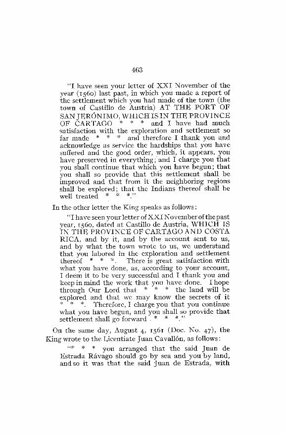
On the zest of November, 156o, the Licentiate Juan de
Estrada Rávago and the Cabildo (municipal council) of the
City of Castillo de Austria, which had just been founded
upon the Bay of San Jerónimo (also called Almirante, or
Bay of the Admiral), wrote to the King, Philip II, advis-ing him of its establishment and bespeaking the roya l
favor. The Monarch replied to both letters on the 4th of
August of the year following; and in the response he
approved in explicit and even enthusiastic terms the colon -ization enterprise that had been begun, encouraging thos einterested to carry it forward and promising them in du eseason the reward that their services merited . Followingis an extract from one of the Royal letters (Does . Nos . 45 ,
46) :
463
"I have seen your letter of XXI November of theyear (1560) last past, in which you made a report o fthe settlement which you had made of the town (th etown of Castillo de Austria) AT THE PORT O F
SAN JERÓNIMO, WHICH IS IN THE PROVINCEOF CARTAGO * " * and I have had muchsatisfaction with the exploration and settlement s ofar made * * * and therefore I thank you andacknowledge as service the hardships that you hav esuffered and the good order, which, it appears, youhave preserved in everything ; and I charge you thatyou shall continue that which you have begun ; thatyou shall so provide that this settlement shall beimproved and that from it the neighboring regionsshall be explored ; that the Indians thereof shall b ewell treated * * * . "
In the other letter the King speaks as follows :
"I have seen your letter of XXI November of the pastyear, í56o, dated at Castillo de Austria, WHICH I SIN THE PROVINCE OF CARTAGO AND COSTARICA, and by it, and by the account sent to us ,and by what the town wrote to us, we understan dthat you labored in the exploration and settlementthereof * * * . There is great satisfaction withwhat you have done, as, according to your account ,I deem it to be very successful and I thank you an dkeep in mind the work that you have done . I hopethrough Our Lord that * * * the land will b eexplored and that we may know the secrets of it
* *. Therefore, I charge you that you continuewhat you have begun, and you shall so provide tha tsettlement shall go forward * * * . "
On the same day, August 4, 1 561 (Doc. No. 47), the
King wrote to the Licentiate Juan Cavallón, as follows :
"* * * you arranged that the said Juan d eEstrada Rávago should go by sea and you by land ,and so it was that the said Juan de Estrada, with
464
sixty men departed and disembarked at the PORTOF SAN JERÓNIMO, WHICH IS IN THE PROV-INCE OF CARTAGO AND COSTA RICA * * * .I have been pleased to learn what has been done i nthis exploration and settlement * * * . "
(2) POWERS OF THE PRIEST ESTRÁDA RÁVACO .
The Royal approval of the founding of the town of Cas-tillo de Austria on the Bay and Port of San Jerónimo, inthe Province of Cartago and Costa Rica, the exploration an dcolonization of which was entrusted to the Licentiate Jua nCavallón, could not have been more clear and explicit ; andin its execution, which he undertook, the Priest Estrad akept and respected the directions given in his commission ,as appears by the legal authority delivered to him by hisimmediate superior in the pursuance of his mission, th eessential portion of which reads as follows (Doe . No . 41) :
°I, the Licentiate Juan de Cavallón, His Majesty'sJudge of the Royal Audiencia of the island of Españolaand his Chief Justice in the Province of Cartago ,Veragua and Costa Rica ;
"Whereas, being informed that it was desirableHis Majesty and his Royal Audiencia of theConfines, committed to me the settlement of th esaid Province of CARTAGO AND COSTA RICA ,which is all the territory that is left in theProvince of Veragua, from sea to sea, inclusive, andwhich begins from where ends the square of twenty -five leagues that His Majesty granted to the AdmiraDon Luis Colombus, toward the west, they beginnin gfrom the Belén River, inclusive, counting by a paralle ltoward the western side of the Bay of COROBARÓ* * * ; in such a manner that from where the saidsquare of twenty five leagues ends, measured in th emanner stated there, begins the said Province of Cartag oand it terminates as the Rio Grande, toward the west,

465
on the other side of Cape Camarón * * * and forthe execution of the aforesaid, and that it may haveits due effect * * * it is desirable that thereshould be a person who may go with my power an dauthority to establish a city or town by the sea at thePort of San Gerónimo, with the people who at thepresent time are gathered and ready in the frigate swhich are in the bake of Granada, by the Desaguadero* * *
"Furthermore, you are to land at the Port of SanGerónimo, and as soon as you disembark you willarrange for the selection of a site and place on whichto settle near the sea, taking care that it may be a health-ful place and fertile * * *; and the place that youshall thus settle you shall call and entitle Castillo deAustria * * * . "
(3) POwys OF THE LICENTIATE CAVALLÓN .
Nor did the Licentiate Cavallón exceed his prerogative sor powers, for by the cédula of 1561 (Doc . No . 42), whichdirected the transfer to him of the charge that had pre-viously been granted to the Licentiate Ortiz de Elgueta ,there was assigned to the discovery and conquest of th eProvince of Cartago and Costa Rica the same extended are awhich had been designated for the "certain territory "spoken of in the cédula granting the Commission tothe Licentiate Ortiz and dated February 2 3, 156o (Doc .No. 37) ; this territory was embraced within the followin g
district : "* * * the Province of Nicaragua * * * on theside of the cities of Nombre de Dios and Panama, betweenthe South Sea and that of the North * * * . "
It is evident that the Bay and Port of San Jerónimowere included within the boundaries stated ; and althoughthe Dukedom of Veragua might seem to have been als oincluded therein, the said dukedom was left quite un-
466
touched, it having been at that very time the subject of a"pacification" at the hands of Francisco Vazquez, actin gunder the instructions of the Crown which had bee ntransmitted to the Licentiate Monjaraz, the Governor o fTierra Firme, and the execution of which was confide dby the latter to the said Francisco Vazquez .
(4) JUAN VÁZQUEZ D$ CORONADO, SUCCESSOR TO CAVALLÓN
.
The successor of the Licentiate Cavallón, Juan Vazque zde Coronado, in the capacity of Chief Justice and Captain -General of the Provinces of New Cartago and Costa Rica ,on behalf of His Majesty and with the solemnities pre -scribed by the laws, took formal possession of the Valleyof Coaza, within the jurisdiction of the said Province ofCARTAGO AND COSTA RICA, and received personallythe caciques, or chiefs, of the settlements called Yaranaba ,Duiba and Duy, who became vassals of His Majest y
the King of Spain . This appears by a notarial documen texecuted before the notary, Cristóbal de Madrigal, in the
village of Hara therein mentioned, on the 24th day o fJanuary, I564 (Doc . No. 51) ; and on the 6th of March
(Doc. No . 51), following, in the village and palenque ofQuequexque, Province of Duy, Vazquez de Coronadolikewise took possession, before the same notary, of thevillages of Quequexque and Taranca, located in the neigh-
borhood and within the region of the Islands of ZOROBARÓ .These villages of Hara, Quequexque and Taranca formed apart of the district assigned to Juan Vazquez de Coronad oin consideration of his explorations and settlements, a smay be seen by an examination of the Commission he
received from the Audiencia of Guatemala for that pur-
pose, which was the same that had been given to the

467
predecessor of Vázquez de Coronado, the Licentiate
Cavallón, and to the one who preceded the latter, the
Licentiate Ortiz de EIgueta .These acts of taking possession were preceded and fol-
lowed by many others of a like character, to-wit :
That of the village of Ua, received from the Caciqu e
Quiribu, dated February i ; that of Chichimecas, receivedfrom the Cacique Yztolin, a Mexican, on February 5 ;
that of the village of Cabeaca, received from the CaciqueQuexeburu on the 1st day of January ; that of the village
and palenque of Cutcurú, between Texbi and Quequexque ,Province of Duy, on February 17, received from the
Cacique Ururava ; that of the village of Bitagara, in thedistrict of Ururaba, received from the Caciques Cengarao
and Arcara, on February 17 ; that of the villages of
Corcorú and Buquicara and Zarabarú, received from th e
Caciques Cengarao and Quiquingaba, February 17 ; that
of the village of Cutcurú, received from its Cacique name d
Ciquinibi on February 17 ; that of the village of Tervi, or
Texbi, received from the Cacique called Quiquincua, withte n
headmen and sixty Indians, on February 20 ; that of the
village of Abebare, Province of Coaza, received from theCacique Ucuburú, on March 22 ; that of Cintara, Provinceof Coaza, received from the Cacique Orobaca on Marc h
22 ; that of the village of Botbe, Province of Coaza ,received from the Cacique Mesabarú on March 22 ; that
of the village of Orizco, received from the CaciqueCirururú, on the same day, March 22 ; that of the village
of Tequemia, received from the Cacique Ayeaye on March
22 ; that of the village of Cabeaca on March 24 ; that of
the villages of Mesabarú, Ucuburú, Duaquita, Ayeaye andthe other villages in that region, of which possession wa s
taken at the village of Ciruro, Province of Coaza, on the
468
bank of the Flazquita River on March 2 4 ; and that of
the village of Minón and many others of the Province of
Tariaca and the rest as far as the city of Cartago, th e
enumeration of which would serve no purpose here .The examination of all these documents' shows that
Vázquez de Coronado went from one extremity to th e
other, and in all directions, over the province that sub-sequently received the name of Talamanca, then known
under the name of Hara, which extended from the Tarir e
River to the Bay of Zorobaró, inclusive, and from th esea to the divide between the watersheds of the two
oceans. That region, like all the rest traversed byVazquez de Coronado, was left thoroughly explored an dmastered by that conqueror, as humane and generous as.he was untiring .
(5) PERAFÁN DE RIVERA, SUCCESSOR TO CORONADO.
Some years later the successor of Vázquez de Coronado,
Perafán de Rivera, carried out a bold exploration in a
direction the reverse of that made by Coronado, entering
on the Atlantic slope and coming out on the slope of the
Pacific. His interesting letter to the King, Philip II, date d
at the city of Nombre de Jesús on July 28, 1571 (Doc . No .58), sketched the story of that bold expedition . From thisit appears that Perafán, together with the nobility an dchivalry of the city of Cartago, including the Roya lofficials, and accompanied by his wife and sons, as wel las religious persons for the preaching of the Gospel, madean entry into the hostile country, in compliance with th eRoyal provisions and instructions, to found a new settle-
León Fernandez, Documentos Para la Historia de Costa Rica,Vol . IV, PP . 293-3 1 7 .

469
ment or that from which he wrote ; and after a wear yyear and a half among those mountains and enemies ,struggling with all sorts of difficulties and privations, andeven insubordination among his own followers (some o fwhom Perafán was compelled to severely punish, whichwas perhaps only pardonable under the peculiar circum-stances which surrounded him) he traversed a hundre dleagues along the North Sea over a rugged and brokencountry in the mountain region until he reached the limi tof the Government of Costa Rica, toward the Dukeda mof Veragua ; he crossed the Cordillera and passed alon gthe slopes of the South Sea for almost another hundre dleagues, as far as the boundaries of his government, toward
Natá, and finally founded in the Province of Coto th ecity that he called "Nombre de Jesús, " with two ports ,one of which he called "Coronado" and the other, " GolfoDossa" (Gulf of Osa or Dulce Gulf), each distant tenleagues from the city. On the shore of the North Sea ,according to the description given by Rivera, the provincehad two recognized ports ; San Juan and San Jerónimo .With regard to the discovery of mines, they were numer-ous in the vicinity of the city of Nombre de Jesús and onthe Río de la Estrella (Changuinola or Tilorio) .
(6) PROCESS OF ARARIBA .
As appears by the important legal document knownas the "Process of Arariba, " begun in the year 157o b yorder of the Governor and Captain-General Perafán d eRivera' (in which the proceedings resulted in the con-demnation to death and the execution of the soldierVicente del Castillo), most of the persons who accom -
'León Fernández, Documentos pava la Historia de Costa Rica,Vol . III, p . 3 .
470
parried the governor had been especially induced to go forparticipation in the colonization of the Estrella River ,above mentioned, a location which embraced within- th elimits of the Government of Costa Rica, had stronglyattracted the attention of the discoverer, Juan Vazquez deCoronado, and numerous followers, on account of th eabundance of gold that had been taken from its waters _But Perafán, tired of the struggle he had carried on agains tthe natural difficulties of the northern watershed and seek-ing the riches that he supposed were easier to secure o nthe slope leading down to the other sea, was unwillin gto found the new settlement referred to in the zone atthe north ; he gave his preference to that of the southwhich, from the previous experience of Coronado, h eknew to be milder, well populated with natives andabounding in savannas suitable for the pasturage ofcattle. This was the origin of the plot to desert from th ecamp, for which the unfortunate Castillo was hel dresponsible .
(7) FOUNDING OF THE CITY OF NOMBRE DE JESÚS .
Governor Rivera laid out the site of the city of Hombr ede Jesús and its district toward the city of Cartago as fa ras Quepo and the territory thereof, and expressly includedtherein Pococi, Aoyaque, Tariaca, Moyagua, Morore ,Cirore, Mohoruboru and Cabeaca, all the Province ofHara (Talamanca), Cicues, Teribí, Quequexque
, Cuxerinducagua, Arariba, Zeburín, Baxca, Bioro, and all th eprovince then discovered, and the territory along th eshore of the South Sea, toward Natá, as far as the limit sreached by the district of the city, within which werecomprised Cobto and Boruca, Cia, Uriaba, Xarixaba,Yabo, Duarca, Tarima, Tabiquiri, Cabra and its terri-
471
tory, Bericala, Orexuxa, and many other villages explored
and to be explored, all of which he proclaimed and desig-nated as districts and within the jurisdiction of said city
of Nombre de Jesús . This founding document was veri-fied with all the usual formalities, before Francisco Muñoz ,
notary of the Government, in the village of Cobto, onthe 6th day of March, 1571 .
This paper supplies a perfect demonstration of theexercise of jurisdiction by the Governor of Costa Rica ,Perafán de Rivera, over the shores of the Bay of Almirant eon the North Sea, and as far as the limits of Natá ,on the South Sea, where many villages embraced withi n
the district of the city of Nombre de Jesús were located .
(8) FOUNDING OF THE CITY OF ARTIEDA .
A new act of formal and solemn possession of the terri-
tories designated as an integral part of Costa Rica too k
place in 1577, on the 8th of December (Doc. No. 67), the
day on which Diego de Artieda Chirinos, Governor an d
Captain-General of the Province of Costa Rica, founded .the city called Artieda del Nuevo Retino de Navarra (Artiedaof the New Kingdom of Navarre), two and half league sup-stream from the mouth of a river discovered by tha tsame captain at the mouths of the Drago and Bay of
Almirante, in the mainland, to which river he gave the
name of Nuestra Señora de la O del Valle del Guaymí ,"PROVINCE OF COSTA RICA" ; of this city, river andvalley he took possession in the usual form, a notarialcertificate having been prepared and executed before the
notary, Juan González Delgado .Artieda sent soldiers from his garrison up-stream for
the exploration of that country, and at a distance of nin e
Fernández, Documentos, Vol . V, p . 36 .

472
leagues, more or less, the chief of the expedition, Captai n
Francisco Pavón, found a valley settled by numerousnatives and well under cultivation in pejibais' and maizeon both banks of the river . He took possession thereofin due legal form and gave to the place the name of th e"Valley of the Pejibais and of Valderroncal," of th eProvince of Costa Rica, before the notary appointed ,Andrés Villegas, on March 5, 1378 (Doc . No. 68) .
(9) FULL APPROVAL OF THE SETTLEMENTS MENTIONED .
All of the foregoing acts by which possession was taken(those by Juan de Estrada Rávago and by Juan Vazque zde Coronado, as well as those by Perafán de Ribera andDiego de Artieda) were duly brought to the knowledg eof the Audiencia of Guatemala and the government o fthe mother country, and they were fully approved, a sappears by numerous documents, some of which hav ealready been cited . Thus it was that the King wroteto Artieda Oil June 3, 1580 (Doc No . 69), in response tothe letter from the latter, dated March 28 of the previou syear, expressing his Royal satisfaction at the fortunateoutcome of his voyage, although the difficulties en -countered by Artieda had delayed the execution of th ematters he had in charge ; and being then free from thos etroubles and knowing how important were the pacificatio nand settlement of the Province of Costa Rica, the Kingcharged him to proceed with the utmost diligence andindustry, and assured him that his services would beremembered and rewarded. The King also addressed aletter on the same date to the Audiencia of Guatemala(Doc. No . 69), stating that he had been fully informed
'Guilielma Utilis .

473
of the entry made by Captain Artieda into his Govern-ment of Costa Rica and of certain settlements made by
him at Bocas del Drago ; and the action on the part ofArtieda was in no wise criticized, inasmuch as it wa ssimply of the, execution of one of the provisions embrace d
in his contract .
(10) GONZALO VÁZQUEZ DE CORONADO, AUTHORIZED B Y
T HE AUDIENCIA OF GUATEMALA TO CONTINUE THE
WORK OFDISCOVERY .
On the 8th of October, 16o1, ' Doctor Alonso Criado deCastilla, Governor and Captain General of Guatemala ,and the President of the Royal Audiencia located there ,delivered in :Is name a p rovisión (a form of writ or decree)authorizing the Adelantado of Costa Rica, Don GonzáloVázquez de Coronado, then the Governor of that province ,to undertake an expedition therein for the purpose of
subjecting the Indians and the provinces to be pacified,from the settled and pacified portions of Costa . Rica asfar as the borders of Veragua and Panama ; that is to say ,all the territory that was included from the forth Se a
to the South Sea and the Valley of Chiriqui .
(II) FOUNDING OF THE CITY OF SANTIAGO D GTALAMANCA.
Afterwards, on April 1, 16O,5, the Governor of Cost a
Rica, Don Juan de Ocón y Trillo, successor of Don
Gonzálo Vázquez de Coronado, granted authority to Pon
Diego de Sojo to go out and chastise th e MoyaguasIndians, and others, in the neighborhood of the village
of Tariaca, against whom complaint had been made by
the inhabitants of the last named village for wrongs don e
'Fernández, Documentos, Vol . V, p . rob .1548—31

474
them in the effort to compel the latter to rise against th e
Spaniards whom they were serving. Sojo succeeded in
completely subjecting the natives of Ateo, Viceita, Que-quexque, Usabarú, Munagua, Xicagua, Acaque, and
Cabécara ; and in order to maintain these conquests h e
founded, at the Kcal de Viceita (Camp Viceita), Province
of Ateo, in the Valley of Duy, on October ro, 1605 (Doc.
No. 72), the city to which he gave the name of "
SANTIAGO DE TALAMANCA ." He provided that city wit h
local officials and laid out its district as follows :
" In latitude all lhe land from the top of /lie Cordillerato the North Sea; and in longitude, from the Tai-ir e-River and the ford that is crossed going front the sai dcity to the Province of Tariaca, all the territory whichruns to the east, which is the length of that province ,as far as the Escudo de Veragua, which is the end thatseparates this government from that of Veragua . "
The founding of the chief town of the district of Talamanca, made by Don Diego de Sojo, as the Deputy o f
Governor Ocón y Trillo, was preceded by a formal recon-
naissance of the Tarire River which was to serve as it s
port and as a route of communication therewith . The
reconnoitering expedition was carried out by the order o f
Sojo on the 4th of September of the year mentioned (16o5) ,
by Captain Pedro de Flores and Sergeant Martin do
Beleño, accompanied by eight other persons as assistants ,
all of whom certified that from the North Sea to Cam p
Viceita (the site of the settlement mentioned), the distanc e
was eight leagues, more or less, over level and dry land ,
and that the river was navigable for rafts and canoe s
to within one league f10m the camp, and that at its mouth
there was a commodious and safe port for frigates, for
there was a depth of three varas (Spanish yards) on the

475
bar at low tide . This was sounded and a narrow ban k
of sand was found, running from east to west, which i s
crossed from north to south. The neighboring coastal
'and was all low, and on the northwest side there was asmall hummock island about a quarter of a league fro mthe mainland .
(12) ALLOTMENTS OF INDIANS M ADE B Y DIEGO DE SOJO.
On October s8, 1 6o5, the same Captain, Diego de Sojo ,proceeded to parcel out the conquered Indians among th econquistadores (those who had been engaged in the con-quest) domiciled in the city of Santiago de Talamanca .This was done in the following manner : Ile first set asid eone-third of the Indians of the Province of Ateo, who,with their cacique, called Ygrama, were allotted to the
Bing ; of the two-thirds remaining a part was taken b ySimón Sanchez do Guido and Pedro Pérez, Spanish resi-
dents of that place ; in the Province of Viceita a part were
taken by Perafán de Rivera, Diego Sanchez Picón ,Francisco Ferreto, Diego de Acevedo and Juan Esteves ;the village (pueblo) of Térrebe was taken by Diego de
Sosa and Juan Alonso ; the village of Curaqua was takenby Pedro Sanchez de Oviedo ; the village of Quequexquewas given to Martín de Beleño and Antonio Rodriguez ;
the village of Usabarú was given to Pedro Flores and JuanFernández ; the villages of Zucaque and Arán to PabloMilanés ; the village of Xicagua to Felipe Monge ; thevillage of Muyagua to Juan de Araya ; that ofCabécarato Francisco Rodriguez and Domingo López ; and the
village of Coxirón-Ducagua to Luis de Fletes, Baltasar
Gonzalez and Juan Gallo de Escalada . '
'Fernández, Documentos, Vol . V, pp. 126-129 .
476
All of these villages (pueblos) were embraced within th earea between the right bank of the Tarire River and th ewest shore of the Bay of Almirante ; and there were lef tfor conquest and distribution the islands of the bay an dthe Indian settlements of Tierra Firme in the vicinity o fthe latter and in the interior to the line of the Dukedo mor province of Veragua .
The village of Ciruro belonged to the Valley of the Duy ,in the Province of Talamanca, the pacification and settle-ment of which were assigned to the Adelantado, Don
Gonzalo Vázquez de Coronado . In this village anencomienda (allottment of Indians) was made by theGovernor, Perafán de Ribera, in favor of Matías d e
Palacios, and on the death of the latter Catalina de
Palacios, the wife of Gaspar de Chincilla, succeeded tothe allotment, and in such capacity petitioned th
e Audiencia to be protected in the possession of said village, he r
rights having been disputed by Juan López de Ortega,Andrés Pérez and Francisco Rodríguez. The Audienciaof Guatemala heard the case and on August 20, 1609 ,issued a renewal of the decree affording the protectio nsought, as prayed for in the petition, and it was verifiedby the same Adelantado in person in the city of Santiag o
de Talamanca of the Valley of the Duy on March 14, 16 10 . 1
h3) SUIT BETWEEN GOVERNOR OCÓN Y TRILLO AND THEADELANTADO GONZALO VÁZOUEZ DE CORONADO .
As was natural to be expected conflicts arose betwee nthe two chief provincial officials, one the Governor o fCosta Rica, Ocón y Trillo and the other the Adelantadoof Costa Rica, Vázquez de Coronado, the former havin g
' Fernández, Documentos, Vol . 1, pp . i 51 16 7 .

9-7 7
been the founder of the city of Santiago de Talamanca,and the latter the authorized pacificator and settler o fthat territory under the Royal provisión issued by the
Audiencia of Guatemala. The matter was determined b y
the provisión of the Royal Audiencia of March 6, 1610 ,in which it was declared that the said city was subject t o
the jurisdiction of the Adelantado .
(14) LETTER OF FRAY AGUSTÍN DE CEVALLOS TO THE
KM -
On March 10, 1610, Fray Agustin de Cevallos, th e
Provincial of the Order of San Francisco, addressed to
the King, Philip III, a long descriptive account of theProvince of Costa Rica (Doc . No. 76), in which he stated
that the said province was the end and conclusion of th e
Kingdom of New Spain on the eastern side, and bordere d
on the Kingdom of Tierra Firme, being 150 leagues inlength from east to west and forty leagues at least—an dundoubtedly more—ill width between the North an d
South Seas . He described minutely the customs of thenatives along the shore of the North Sea and, referrin gto the section extending from the Tarire River to th eEscudo de Veragua, he gave the most interesting detail s
as from one who knew every foot of the region . He
devoted special attention to the Provinces of Terribí el
Grande and Terribí el Chico (Big and Little Terribí) ,
situated on the Bay of Almirante . He expressly mentioned
the hills of Corolapa, likewise situated on the same bay at
the place where the Estrella (Changuinola) River empties
a prodigious river, the golden sands of which were defende d
and guarded by a warlike nation called the Horobarós,that lived along its banks on the side emptying into th e
sea. This coast also had many ports, both in the rivers,

478
which were large, as well as in Almirante Bay and Bocas
del Drago, with good and safe anchorage . But, he said ,
all the greatness of this territory was lost because the
Spaniards of Costa Rica were so few in numbers, and he
concluded by recommending that people be sent out from
Castile to settle along the Estrella River .
(15) REBELLION OF JULY 29, 1610 .
On July 29, 1610, early in the morning, there was ageneral uprising in the Talamanca region, which resulte d
in the death of a number of soldiers, women and children ,the wounding of other soldiers, the burning of the cit y
of Santiago and the siege of its population, which too k
refuge for thirty-six days in the fort of San Ildefonso, unti lthe arrival of aid sent from the city of Cartago by the
Governor, Don Juan de Ocón y Trillo . In consequence
of this general insurrection, the city of Santiago wasabandoned, and on being informed of thi s unfortunateevent, the Audiencia of Guatemala mad e arrangementsfor the reconquest of that region .
11 . FROM 1612 TO 1700 .
(I) MEASURES TAKEN BY THE AUDIENCIA O FGUATEMALA
FOR THE RECONQUEST OF TALAMANCA .
The measures taken by the Audiencia of Guatemala fo r
the reconquest of Talamanca, after the compulsory aban-donment of the city of Santiago which had been founded
by the Governor Don Juan de Ocón y Trillo in 1605, were
energetic and effective . Pedro de Oliver, theAlcalde
mayor of Verapaz, was charged by the Audiencia with theexecution of such reconquest and, with the help of Do n
Fernández, Documentos, Vol . VIII, pp. 136-138

479
Sebastián Chacón de Luna, the old site of Santiago wasoccupied by Oliver, in 1612, and chastisement meted out
to the rebellious Indians . Sickness and other troubles ,
however, made the result of the campaign of little value
and matters went on as they had been before (Doc . No . 83) .
(2) PROPOSALS MAD E TO THE CROWN FOR RECONQUEST.
Later on repeated proposals were made to the Crown toundertake the formal reconquest of the Talamanca region ,
among them the following : by Diego del Cubillo, in 1617 ;
by Don Gregorio de Sandoval, in 1638 ; by Don Francisc oNúñez de Temiño, in 1648 ; by Don Andres Arias Maldo-
nado, in 16,59, and by Don Juan Fernández de Salinas, in
1681 (Doc . No. 8y) . Of these, only the one before th e
last, that of Maldonado, had any result. It will not benecessary to refer to these proposals further than to take
from them such data . as they may contain in reference to
that important region .
In the memorial of Captain Diego dei Cubillo Calderón
(Does. Nos . 79, 8o), a resident of the city of Cartago i n
the Province of Costa Rica, the petitioner stated that i t
had been six years, more or less, since the Indians of the
Valley of the Duy and the Mexicans of that province ha d
risen in rebellion against the city of Santiago de Talamanca ,
the population of which was Spanish, and asked to b e
authorized to subjugate and reduce the Indians of thi s
valley of Duy and the Mexicans, that being where th e
city of Santiago de Talamanca had been located. The
Fiscal objected and the petition was not acted upon .
Don Gregorio de Sandoval stated in his proposal (Doc .
No. Si) that the province of Duy was forty leagues, more
480
or less, from the city of Cartago, and that in the year lore ,the city of Santiago deTalamanca was located therein, fromwhich the said Province and Valley of Duy took its name ,the said valley having a cordillera or range of mountains i nits midst and bordering on the Province of Guaymí, 'til esettlements of which extended from the river calledEstrella (Changuinola), Bocas del Drago or Bay o
f Almirante, as far as the Government of Veragua. 'that the.city of Talamanca had been located on the bank Of a
river named "Tarire, " which emptied into the North Seaat a distance of fourteen leagues from the city, and wa snavigable for sailing vessels . This petition also came tonaught .
The petition presented, by Don Francisco Núñez d e
Temiño (Doc N o . 82) bore daté of November 26, r648 . Itstated as the boundaries of the province, the North Sea from
the Desaguadero (outlet) of the Lake of Nicaragua t o a pointnear the river known as Calobébora, having in front, in thesea, the Escudo de Veragua, an island distant between eightand nine leagues from the main land . Temiño spokevery
enthusiastically about the Bay of Almirante, which wasincluded within the territory of the province, and wasformed by the three islands named Toxa, or Bocas delDrago, and sometimes known as "islands del Viejo, " forwhich reason it was the best and safest port Known in th egreater part of the world .
Special mention should be made of the petition of Gov-ernor Don Andrés Arias Maldonado, dated July 8, 1 659 . 1In it that official stated that on the 12th of May previou she set out from the city of Cartago, the headquarters of theprovince, to investigate a port on the North Sea (th ename of which was not stated, but from the description h e
'Peralta, Costa Rica y Colombia, p . 5 2 .

48 1
gives of it, it must have been the one known by the name o f
Portete in the Bay of Minón) . It was a port sheltered
from all winds, with an entrance large enough for two
ships, while inside it could accomodate twelve or fourteen .
The location was cool and there was a small stream o f
fresh water (tile Piuta) . He then explored the region alon g
that shore, to the southeast, to see if it had any beach, an d
after traveling a short distance came to the end of therough sea on the rocky coast and found a very smoot hbeach and a bay large enough to hold two hundred ships .The entrance was by two channels, separated by an islan dlarge enough for the erection of a fort to guard them .The entrance was to the eastward, where also the islan dsheltered the port He found the country very pleasan tand abounding in all kinds of products, the cacao grovesbeing the best the governor had ever seen ; there were also
yuca and plenty of cotton trees and maize fields. Maldonado added that the Tarire River, in the Valley of th e
Duy, where the Talamanca and Ateo Indians lived , was
some distance from the port that had been found . Six
leagues from the latter was a river called Dugre and, in
between, a fordable stream having but little water .In a letter of the same date, addressed to the secretar y
of the King,' he said among other things, that th e Ateos
lived on the banks of a river called Coyn (Coén) .
(3) THE AUDIENCIA OF GUATEMALA AUTHORIZES DON ROD-
RIGO ARIAS MALDONADO TO MAKE THE RECONQUEST.
Shortly afterwards occurred the death of lion Andrés
Arias Maldonado, on November 25, 1661, and his son
Don Rodrigo received from the Audiencia of Guatemala
'Peralta, Costa Rica y Colombia, P . a{ .
482
a provisión, delivered on October 1 7, 1662 (Doc . No . 86) ,
authorizing the latter, in the capacity of Governor and
Captain-General of the Province of Costa Rica, to procee dwith the expedition he had undertaken into the territoriesalong the Tarire River and the regions adjacent ; theseregions were inhabited by various tribes of Indians calle d
the Urinamas, Ciruros, Moyaguas, Tariacas and others ,which were subjected and conquered by Don Rodrigo an d
placed in a location on the bank of said river . And h e
likewise reduced and pacified the Talamanca Indians, al l
in conformity with the specific instructions detailed in th e
provisión mentioned . That provisión was based on th e
authority granted by the Crown to the Audiencia above
named, by the Royal cédula of March 21, 16,54 'Arias was deserted by his soldiers and left alone an d
abandoned in the heart of the Talamanca mountains, bu t
some Indians who remembered the kind treatment the y
had received from him led him safely to the neares t
Spanish village . After these experiences the Captai n
resolved to give up all worldly things and consecrate hi m
self to religion .
(4) GOVVRNOR SÁENZCONTINUES THE WORK.
The successor to Arias, Don Juan Francisc o Sáenz,
undertook to carry on the subiection of Talamanca. At
his own expense he sent thither Fray Juan de Matamoros ,
who certified, on May 4, 1675 (Doc. No . 88), that between
the 2d and the 15th of February, immediately preceding ,
he had baptized a hundred and twelve Indians amon g
the tribes of the Cabécaras, Nucuebas Cururos, Chicagua s
'Peralta, La Géographie Historique et les Droils Territoriaux
de Costa-Rica, p . zoo .
483Tariqui, Tarici, Urinamas and Urarubos, who wer
e embraced in that part ofTalamanca which lay along th eTarire River on the -North Sea as fat- as the Estrella (Char-guinola) River and that there remained to he taught an dbaptized about five hundred families of the said tribes ,which had been subjected by the efforts, and at th ecost of the said governor, those who were baptized weresettled in Coruro and Conemara .
In the report of Señor Sáenz to the Crown, datedDecember 2,9, 16,6 (Doc. No . gothat governor statedthat the jurisdiction of the Province of Costa Rica ex -tended from the mouth of the River Sara Jua
n del Desaguadero(outlet)of Granada,Nicaragua to the Estrella(Changuinola) River. It was proposed to make settlements an dbuild churches in the territories where the Indians dwelt ,between the Tarire and Estrella (Changuinola) Rive rand as bells and furniture for such houses of worship wer elackin>, a request was made therefor .
5)ROYALGÉDULAOF 1691RELATINGTHERETO.NARRATIVES OFBISHOPDELGADO,orFRAY FRANCISC O
DE SAN JOSÉ AND FRAY PABLO D EREBULLIDA
By the Royal cédula of May 3, 1691, orders were givento the Governor and Captain-General of Guatemala an dthe President of its Audiencia, to take steps in accord wit hthe Council of the Indies, to arrange with Fray DiegoMacotela, Provincial Vicar of the Order of San Francisco,for the advancement of the work of converting the, Indiansof the Province of Talamanca, in the Government of CostaRica . A similar cédula was sent to the Governor andCaptain-General of Costa Rica . On the same date th e
Peralta, L a Géographic Historique, p . 238 .
484
King addressed a communication to Fray Diego Macotel atelling him that the cédula referred to had been sent tothe President of the Audiencia of Guatemala and to th eGovernor of Costa Rica, and that he was very earnestlyrecommended to continue the work, for which purpos ehe was to put himself in communication with the sai d
president and governor .
On December z4, 1 692, í a very important report wa smade by the Bishop of Nicaragua and Costa Rica, Fra y
Nicolás Delgado, to the Supreme Council of the Indies ,concerning the subjection of Talamanca by th
e Missionaries, Fray Melchor Lopez and Fray Antonio Margil .
In it that prelate stated that in compliance with the
commands contained in the Royal cédula he laid befor ethe Council the condition of the conversions among [li e
Carib Indians who lived within the limits of his bishopric .
Ile spoke very highly of the apostolic labors of the friar sreferred to . He alluded to their work in Talamanc a
among the Indians of that name —the 'icrrabas, Cabé-
caras, Chicaguas, Usamboros, Cabxes, Usuros, Moyagiles ,
and many others— and recommended that their subjection
be accomplished by the Divine Word, by good example ,
poverty and patience, in the way that had been done by
the Fathers Melchor and Antonio .
On October r8, 1 697, the report of Fray Francisco d e
San Joseph was written to the President of the Audiencia
of Guatemala (Doc. No . r,,7), wherein he described in
great detail the tribes embraced within the Province o f
Talamanca, the occupations and trade of the Indians, th e
number of their houses and palenques, their food, the
distances between the tribes, etc. He included in this
Peralta, Costa Rica y Colombia, p . 78
485
Province of Talamanca the '1errabas, the Chánguenes, theToxares islanders, the Urinamas and the Cabécaras .Appended to that report was an itinerary of all th evillages from the Tarire River to the Island of Toj a(Island of Colón) in Almirante Bay, with a statementof the number of days required for the journey in passin gfrom one to another, the number of their inhabitants, an d
the number of the Indians who had been married an dbaptized .
' ['his report was confirmed and amplified on March 26 ,reps (Doc. No. 138), by the Apostolic Missionary, FrayPablo Rebullida with the addition of some data as t omany other Talamanca settlements .
In 1699 (Doc No. 139), the Missionaries, FrayFranciscode San Jos& and Fray Pablo de Rebullida, wrote concern-ing the Uninamas, the Cabécares, the Talamanca an dTérrabas, the Chánguenes and the Tojas, saying thatamong the Chánguenes there still remained more tha ntwo thousand to be baptized, all within the jurisdictio nof the Province of Costa Rica .
(6) THE MISSIONARIES GRANTED rim Ali) Or' AN ESCORT .
In the year following, on July 22, 1700 (Doc ",0 . 1 40) ,Don Gabriel Sánchez de Berrospe, President of the RoyalAudiencia, Governor and Captain-General of the Kingdomof Guatemala, with the advice and consent of the Boar dof the Royal Hacienda of that Kingdom and having befor ethem the report sent in by the Reverend Fathers, Fra yFrancisco de San Jose and Fray Pablo Rebullida, theApostolic Missionaries who had been engaged in thesubjection and conversion of the heathen Chdnguen eIndians of Talamanca, in the Province of Costa Rica,recommended that these missionaries be given an escort
486
of thirty soldiers, each to be paid eight pesos per month .
At their head was to be the Fieldmaster Don Miguel d o
Chavarria with a salary of sixty pesos amonthly . For
this the necessary despatches were sent to the deputy o f
the Royal officials of Costa Rice, to arrange for the pay-ment of the said leader and the thirty men, and for othe r
expenses, both for maintenance as well -as other things
that might be needed by said men and the care Mud lielp
of the Fathers, which expenses were to be paid out of th e
Royal hacienda and take precedence over all other matter s
in accordance with the will of His Majesty and for hi s
Royal service . The Governor and Captain-Gencral of the
Province of Costa Rica were required to enlist the thirt y
soldiers who were to support the said Fathers in the cam-
paign of conversion .
(7) SEÑOR FAJARDO APPOlNTED DEPUTY GOVERNOR O F
MATINA AND THE BOUNDARY OF HISJURISDICTION
FIXED AT THE BAY OFALAMIRANTE.The review of the documents relating to the 1 70 1'
Century will be closed by noting one of considerable im-portance : the appointment by the Governor and Captain -
General of Costa Rica, Don Francisco Serrano de Reyna,
of Don Rafael MoxiMes Fajardo, on October 30, 1700
(Doc . -No. 628), to the office of Deputy Governor an d
Captain-Gencral of the Valley of Matina, Suerre an d
Reventazón, on the north coast of said province, ifs port s
and jurisdiction, which were expressly extended by tha t
instrument as far as Almirante Bay .
487
111 . FROM 1703 TO 1744.
(r) REPORT OF GOVERNOR SERRANO DE REYNA TO
THE CAPTAIN-GENERAL OFGUATEMALA.
lie events connected with the conquest of Talamancaduring the 18th century will now be related .
And first, reference will lie made to the report sent by th eGovernor of Costa Rica, Don Francisco Serrano d e Reyna,to the President, Governor and Captain-General of Guate-mala, dated July 2 r, 1 703, in compliance with the instruc-tions given by the Board of the Royal Hacienda in thatcapital In that report Senor Reyna stated that theReverend Fathers, the Missionaries Fray Francisco d oSan Jos,' and Fray Pablo Rebullida, set out from the cit yof Cartago, the latter by land and the other by way o f
Matina with the thirty men that had been recruited bygovernment order . When Padre San Jos& reached th e
IsIand of T oxa, the Indians attached bin: and he mad e hisescape badly wounded, besides having the misfortune t olose the largest boat with all the supplies . On account ofthis mishap he was compelled to leave the commande rand most of the men on the mainland . In a small canoe heprocceced to Chagres, and from thence to Panama, wherehe received assistance from the President of that kingdom .He returned in a sloop, gathered tip the then and soughtto enter Talamanca by way of the mouth of the Estrell a
(Changuinola), but for lade of a pilot he was not able t oaccomplish this and had to go on to Matina, where, whenabout to enter the said river the sloop was seized by th eenemy with all it contained . This loss brought his enter -prise to an untimely end .
Teralta, Costa Rica y Colombia, P . 95 .

488
It was the opinion of Governor Reyna, that the regionin which he had sought to settle was not suitable for tha tpurpose and in its stead he suggested the more desirabl eBoruca country on the South Sea . He added that inaccordance with the orders given lie was proceeding wit hthe enlistment of the thirty men for the escort of th e missionaries.
(2) REPORT OF GOVERNOR HERRERA CAMPUZANO .
On June 8, 1705, the successor of Reyna, Don Diego deHerrera Campuzano,' in his turn reported as he had bee ndirected to do by the Reduction Committee concerning th eheathen Indians of Talamanca in the Province of Cost aRica. He stated that the ten men who had been deter-mined upon to undertake the planting of yuca and plan-tains, had been sent forward provided with everythin gnecessary for that purpose . They had been instructed t obegin the work at Tuis and end at Urinama, that beingthe best location for the camp and plaza de arnias for thefifty soldiers who were to enter the country for the subjec-tion of those heathens . According to the opinion of theReverend Fathers, Rebullida and Andrade, who were the nin the city of Cartago, although the winter having alreadyset in, the maize-fields could not be worked, the clearing no thaving been done during the dry season.
With regard to the appointment of a leader for the com-pany of fifty men that had been recruited by the com-mittee under Captain Don Francisco de Noguera, with al ldue respect he objected to the latter on account of his lackof experience and knowledge of penetrating wild andrugged mountain regions, and respectfully recommende d
'Peralta, Costa R ica y Colombia, p . 99

489
for the command two practical and capable men who were
also brave and experienced, Captain Don Francisc o
López Conejo, who had been alcade ordinario and captain
of infantry in the Valley of Marina and on the shores of the
North Sea, and Captain Esteban Nieto, who had already
been in the mountains and had brought out many Indians .
(3) REPORT OF THE PADRE MARGIL TO THE PRESIDEN T OF GUATEMALA
.
In that same year, the Padre Fray Antonio Margil, 'Apostolic Preacher and Missionary of the Province o fTalamanca„ reported, raider date of September 14, 3705 „as he had been asked to do by the President of Guatemala .He stated that he went with the escort of fifty men, underthe command of Don Francisco de Noguera y Monada,accompanied by two friars, missionary associates of his,named Fray Antonio Andrade and Fray Lucas Morillo yRivera, and preceded by another friar named Fray Pablode Rebullida, charged with gathering allthe caciquesor chiefs of those regions and getting them to come out an dmeet the expedition . In this the last named friar was suc-cessful, but Fray Margil had to turn back in obedience t othe command of his superior, the Commissary General ,resident in Madrid, for the purpose of founding a mission-ary college near the city of Zacatecas ordered by Hi sMajesty .
He then proceeded to give important details concerningthe subjection and stated that he had appointed the PadreAndrade to take his place, as President of the Missions .Regarding the expenses of the expedition, it was defraye dby the four payments advanced to the men ; to each of thefriars a jar of wine was provided for the celebration
Teralta, Costa Rica y Colombia, p .101.íí48_.. 3z

490
of mass, and to all forty pesos for wax and bread for thesacrament . He also recommended that the leader of th eparty be allowed something for presents to the Indians ,such as beads and iron articles with which to attract themthe more easily .
(4) RtPORT OP THE MISSIONARIES ANDRADE AN D REBULLIDA.
On January to, r709 (Doc . No. 145), the Reveren dFathers Andrade and Rebullida made a report concerningthe progress of the missions, describing minutely Tala -manca and giving the itinerary of the villages embrace d
therein .The number of churches built numbered fourteen, an d
therein the Indians attended mass and received Christia ninstruction in their own tongue . Peace was made betweenthe tribes of Térraba and Talaranca and 95o children
were baptized. In the first settlements 34 marriage s
were celebrated and roads were opened from the city o fCartago to the Province of Térraba that being the las tone that was reached. The number of children that ha ddied was given, and also the number of the inhabitants o f
theregion. Peace was reigning with the Tójares or islander swho belonged to the Térrabas tribe . Minute detail swere also given as to the Chánguenes and information as t othe Zeguas, Almirantes and Guaymiles, who lived beyondthe Chánguenes . He was of the opinion that it was notdesirable to settle Spaniards in Talamanca, but rathe rrecommended the plan of removing the Indians to Boruca ,Chirripó and Teotique .
The itineraries of the Talamanca villages are complete ,as well as the census of the population of the numerou s
villages mentioned in the report. '
'See Bishop Thiel, Map of the Missionary Stations ofTalamanca (map XLVI) .

49 1
It appears that the reduction was carried out with thegreatest success in January, 1709, the month in whichthe report was made .
(j) INSURRECTION OF SEPTEMBER 28, 1709 .
This proved a grave miscalculation, for on the 28th ofSeptember of that very year a general insurrection tookplace among the Indians of Talamanca, an account o fwhich was given by Padre Andrade to the Audiencia ofGuatemala in his letter of October 21, following.` Therebellion extended to all quarters, from Urinama on thebanks of the Tarire to the Island of Tójar in Almirant eBay. The Indians killed ten soldiers, one woman, a childand the Reverend Fathers Rebullida and Zamora, burnin gthe bodies, setting fire to the churches and images of th esaints, and carrying off the holy articles. The commander o fthe soldiers escaped with eighteen of his men, two of who mwere wounded . The Cabécaras, Talamanca and Térraba sleagued together, the Chirripó Indians alone not takin gpart ; as to the rest, those who did not actually join in th eattack knew of it, consented to it and kept silence .
(6) PROCLAMATION OF GOVERNOR GRANDA Y BALBÍN .
On February 1 ,5, 1710 (Dec . NO . 148), Don LorenzoAntonio de Granda y Balbín, Governor and Captain -General of the Province of Costa Rica, in compliance withan order received from the Superior Government ofGuatemala, made a public proclamation in which th enatives of the said settlements of Boruca, the Téxabasand the Térrabas and the islanders of Tójar were notifiedthat to all those who would come in and yield obedienceto the governor and captain-general of the King and
'Peralta, Casta Rica y Colombia, p . ios
492
Master a pardon was offered in his Royal name for the
offences committed ; but that those who should not thusobediently submit themselves were declared to be rebelsand traitors to both their _Majesties, deserving of bein gburned alive, as they would be io the war that was there -upon declared against them.
On the 28th of the same month (Doe . No. 149) the saidGovernor Granda v Balbin wrote to the President ofGuatemala that the Téxabas had _yielded their obedienc eand that with them carne from the north fou r of theTérrabas who promised that their tribes would also com ein and do likewise ; and they went with some of those fro m
Boruca and two Spaniards to open the road to Viceita ,
that being the best settlement in Talamanca. Thegovernor went forward with one hundred and twenty
men, and Don José de Casasola entered Talamanca by
way of Chirripó, with eighty more .
It was proposed to have the Térraba Indians of the
north brought into the settlements and not leave a singleTalamanca Indian in the mountains, and also to seize th e
Island of Tojar and compel those of Bocas del Toro to
surrender, so that there would he more than ten thousan d
natives comprised in the conquest of Talamanca .
(7) REPORT OF BISHOP GARRET Y ARLOVI .
A little before the general uprising His Majesty had
directed the Bishop of Nicaragua and Costa Rica, Fray
Benito Garet y Arlovi, to be very careful in regard tothe maintenance and progress of the subjections and als o
to see that the natives were well treated ; and that prelate
undertook to report to his Sovereign concerning thosematters shortly after the serious attack on the Talamanc a
missions. His report was dated November 3o, 1711 (Doc .
493
No . 1,5 1), and it is a document historically of the highest
rank ; in it Bishop Garret lays before the Monarch the
true and only justifiable reasons for the bad results of al lthe pacifications undertaken in the name, and with th e
authority of the King.
(8) ENTRY OV GOVRRNOR GRANDA Y BALBÍN INTO
TALAMANCA APPROVAL BY THE GROWN .
Governor Granda y Balbin made his entry into Tala-
manea and arranged a juncture at San José d e Cabécarwith the Fieldmaster Casasola, establishing his head -
quarters at that place, from whence various expedition swere made and more than five hundred natives of bothsexes and all ages were gathered up and carried boun dinto Cartago, where they were distributed among the
soldiers of the expedition .
The course pursued by Governor Granda y Balbi nmet with the entire approval of His Majesty, as appeared
by the two cédulas of September n, 1713 (Doc. No. 152) ,
one of which was directed to the President o f Guatemala
and the other to the Governor of Costa Rica . In these
the Monarch stated positively that the Talamanca conques t
belonged to the Province of Costa Rica, and directed a com-
mittee composed of officials and persons familiar with
that territory to meet with the Superior or Superiors o f
the _'fissions and discuss very carefully what was best
to be done to reestablish the missions of Talamanca o r
develop those of Boruca and put then in a condition for
perfect defense, in order to prevent any possible communication by the Mosquito Zambos with the territory situa-
ted between Costa Rica and Panama. The punishment
inflicted upon the principal head of the insurrection wa salso approved, as well as the distribution of the Indian s
taken from Talamanca
494
(9) THE NATIVES OF TALAMANCA PERSECUTED B YTHE
MOSQUITOS. NEW PROJECT SFOR RECONQUEST.
Some time elapsed during which the Indians of Tala-inanca were neglected and the Mosquitos and their allie s
found opportunities for enslaving them . In this seriou ssituation the Talamancas sought 'favor with the provincia l
authorities of Costa Rica ; and it was to this new circum-stance that reference was made in the despatch of th e
Governor, Don Antonio Vazquez de la Ouadra, to th e
Captain-General of Guatemala, under date of May 23 ,
1736,' concerning the offers of submission made by th e
Talamancas . The governor asked for the assistance of
friars to take charge of their instruction .In accordance with the representations made by Gov-
ernor Quadra the President of Guatemala addressed a
communication to the King, on the 10th of September of
the year mentioned,' objecting- to the plan of undertakin g
the subjection of Talamanca by the use of arms and war-
like efforts, as had been discussed in the committees ,
recommending instead that mild and prudent means
should be pursued, and that an escort of not more than
twenty-five men with their officers should be provided .
In that communication he makes it clear, by a very posi-
tive statement, that the region of Talamanca belonged t o
the Province of Costa Rica, and that it was within the
district of the Kingdom of Guatemala, next to Tierra Firma
'Peralta, C . R. y Col ., p . z32 .°Peralta, C . R. y Col ., p . 1 34 .
495
(1o) ROYAL CÉDULA OF 1738 PROVIDING FOR TH E RECONQUEST.
Notwithstanding the very reasonable opinion of thePresident of Guatemala, His Majesty Don Philip V, byRoyal cédula of May 21, 1738, saw fit to provide that thesubjection of Talamanca should be undertaken immedi-ately, in the way that it had been determined upon b ythe committee at the meeting held in the city of Guate -mala on June g, 1726, and that the expenses for thisenterprise should be appropriated for in preference t oany others for which the collection offices in that city o r
in the rest of the jurisdiction of the Audiencia, might be
liable to vassals resident in Spain, so that the subjugatio nand conversion of the Indians might take precedence ove reverything else, as provided bylaw. Therefore the Presi-
dent of Guatemala was commanded to give the mos teffective and necessary orders for the execution of th eaforesaid Royal determination, as soon as he shoul dreceive the despatch .
In response to the order received, the President o fGuatemala, in a letter addressed to the King, of Novembe r4, 1740, '- stated that although he had made preparation sto carry out the Royal cédula, of May 21, 1738, he had beencompelled to suspend them and attend to other mattersof greater urgency ; he referred to the execution of th eRoyal order of August 30, 1739, 3 in which he had beencommanded to give his best attention to the exterminationof the hostile Mosquito Zambos who threatened theProvince of Guatemala . This course, he said, was all
'Peralta, C. R. y Col ., p . 139 .2 Peralta, C . R. y Col ., p . 157 ."Peralta, C. R. y Col., p . 147 .

496
the more necessary, because war against the Englishhaving been declared, he had been compelled to emplo yall the resources within reach in the defense of thos edominions, without undertaking any new conquests o fpeoples who were doing no harm whatever, but were dis-posed to receive ministers who would instruct them with -
out armed demonstration .
(11) ROYAL CÉDULA OF 1740 PROVIDING FO R THERECONQUEST.
On May 24, 1740,' a Royal cédula was issued to thePresident of Guatemala, approving the steps taken b yhim for the subjection of Talamanca as set forth in theletter of Novernber 1 5, 1737, and carried out in compliancewith the Royal cédula of May 22, 1735 . In it the Monarchreproduced—not only without correction, but with taci tapproval —the words of the Governor of Costa Rica, bywhich he stated that from the year 1710 the missionsin the mountains of Talamanca, under the jurisdiction ó(said Governor, had been suspended and had made n oprogress whatever .
The letter of the President of Guatemala, dated Novem-ber 4, 1740, having been laid before the Council of th eIndies, the suspension of the Royal cMula of 1738 wasordered ; this was done by a further cédula dated Oc-tober 31, 1742 (Doc . No . 165) .
(12) THE CONVERSION OF THE NATIVES CARRIED ONWITHOUT A N ESCORT.
The work of teaching without escort went on unde rFathers Mendijur, Otalaurruchi, Vidaurre Murga, Cabell oand Nunez . In Cartago the Fieldmaster Fernandez
`Peralta, C. R . y Col., p . 152
497
de la Pastora deeming the missionaries in danger, deter -mined to use twenty soldiers on his own account an d
with these and twenty-five of the King 's men, all under
his own command, he entered the mountain region an dtook out one hundred and twenty-three natives ; these
lie settled near Cartago .Subsequently, the same Pastora, with an escort of fift y
men allowed him by the Superior Government of Guate -mala and fifty more provided by himself, and some fur-
nished by private individuals, made a second entry int o
Talamanca and brought out three hundred and four -
teen natives, who were distributed among the villages o f
Atirro and Tucurrique, of Cartago .
(i3) REPORT OF GOVERNOR FERNÁNDEZ DI: LA PASTORA .
On June 1, 1749, the Governor Don Francisc o Fernández
de la Pastora, made a report of his two expeditions intoTalainanca to the Brigadier Don Alonso Fernandez de
Heredia, General Commander of Nicaragua and Cost a
Rica. The report was a very long one, the most impor-tant features of which are the facts that his work wascarried on among the tribes of Viceita, Cabécar, Chán-
guene, the -Nortes, Borucas, Franciscans and Cabagras ,and that three villages were formed with the natives
brought out of the mountains one at Cape Blanco ,
jurisdiction of Nicoya, with the adults and prisoners, fo r
fear of their escape to the mountains ; another with th e
smaller ones at Tres Rios, near the city of Cartago ; and
another village, formed at their own request, by volun-teers, in the section named Pejivaye, between Tucurriqu e
and Atirro .
Peralta, C . R . y Col ., p . 168

498
IV. FROM 1750 TO 1800 .
(1) ROYAL C ÉDULAOF 1756.
On November 30, 1756, the King of Spain issued a ver y
important cédula (Doc. No. 17o) concerning the Missions
of Talamanca of the Province of Costa Rica, in which som e
very positive statements were made . Therein His Majesty
approved the resolution taken by the Committee for th eRoyal Hacienda of Guatemala and communicated to th e
Monarch by the Governor and Captain-General of that
Kingdom by the letters of June 10 and September 15,
175,5 ; according to that resolution thirty men were to be
added to the guard located in the city of Cartago, which ha d
theretofore numbered but twenty, and had been designed
especially to accompany and serve as an escort for th e
missionary friars occupied in the conversion of the native s
in those mountains. The thirty soldiers thus added were
to live with their families in the village of San Francisc o
de Terraba, so as to be there ready for the discharge of
their duty. The appropriation for the friars was als oincreased to the Sam of 450 pesos for each missionary. It
was decided to suspend the Missions of Tologalpa (i
n Honduras), keeping up those of Costa Rica, and His Majesty ,
in closing, directed that two expeditions be made annuall y
into Talamanca, in different places .
(2) REPORT Or PADRE URCULLU .
On November 3, 1763, the Padre Manuel Urcullu ,
Guardian of the College of the Propaganda Fide of Christ
Crucified, of the city of Guatemala (Doc . No. 172), pre-
sented to the Superior Government of Guatemala, in com -
pliance with the Royal cédula communicated thereto, a
report concerning the missions and subjection of Tal-
499
anumea, of the Province of Costa Rica, distant from th e
city of Cartago more than eighty leagues . After describ-ing the country, its situation, contour, productions, etc . ,he went on to say that the tribes known there as Tala-mancas were seven in number . The first of that nam e(Talamanca) embraced two others, called Cabécaras ari dViceitas ; the second, the Térrabas; the third, theThóxares, by reason of living on an island of that nam eupon the shore of the North Sea .' The fourth was calledChanguen and the fifth Zegua ; the sixth Thorasque andthe seventh Guaymi . Of these the three last namedoccupied the borders of the Kingdom of Tierra Firme andthe four first above mentioned were located within Guate-
mala. So that it was the positive declaration of th esuperior head of the missions that the tribes of the Tala-
mancas, Viceitas, Cabécares, Térrabes, Tójares and Chan -guenes unquestionably belonged to Costa Rica .
(3) ROYAL CÉDULA OF 1770 AND REPORT Or GOVERNO R
DÍEZ NAVARRO .
The Royal cédula of July 8, 1770 (Doc No . 173) ,
addressed to the council, the justices and regimiento (munic-ipal administration) of the city of Guatemala is of muchimportance in the matter now being considered, because i tdistinctly appears therein, without room for question, tha tof the missions under the charge of the College of Chris tCrucified of Guatemala, part belonged to the Kingdom of
Tierra Firme and part to the Kingdom of Guatemala .It was the King who spoke : Tierra Firme, he decreed,
embraced the four tribes of th e Chánguenes, DoracesDolegas and Guaymíes, who lived within the jurisdiction o f
'The Island of Tóxar or Colón in Almirante bay
500Panama under the Government of Santiago de Veragua ,BORDERING UPON THE IIISSIONS OF TALAMANCA . Asto the latter, although the Governor of Costa Ricaapproved the proposal of entry with an armed force—a sdid also the Committee of the Royal Hacienda and th eArchbishop and the President of Guatemala— a completereport was asked for on account of its serious character .
To furnish the Crown with the data, the Superior Gov-ernment of Guatemala procured the fullest informatio nand the Engineer, Don Luis Diez Navarro, who was Gov-ernor of Costa Rica, reported on April 4, 1771 (Doc . No .240), to the following effect . He stated that th
e Talamanca Missions were more than a hundred leagues distan tfrom Cartago, the capital of the Province of Costa Rica.In that city the Reverend Fathers of the Propaganda Fid ehad their headquarters and there they had also a hospic efrom whence its missionaries went forth over the rugged ,marshy and mountainous country, crossing numerou slarge rivers and passing through regions inhabited bythose savage tribes . The Indians belonged to variousnations, but there were two in particular that were th estrongest, the Térrabas upon the South Sea and file Nortesupon the North Sea. These were bounded by theAlmirante or Fstrella River and by an island called Tójar,which they themselves had settled . This and the Tala-manca coast was held by the Vote Indians of Talamanca .From thence the Zambos and Mosquitos went to the shoresof the Province of Veragua, belonging to Panama ; andfrom Veragua they returned again to their own habitation .
It was his opinion that if the Reverend bathers proceede dapostolically they would not achieve any useful result ; headvised, therefore, that the method used in the year 174 3be employed, and that San Francisco de Térraba be con-

501
verted into a center of operations, it being moreover a
locality desirable for settlement by families of peacefu l
natives .Another of the reports brought forth in compliance with
the Royal cédula mentioned, was that made by Dori Jos&Joaquin de Nava, Governor of Costa Rica, which bore dat eNovember 1 5, 1771. In that report Señor Nava sup-ported the idea of an expedition, which the Reveren dFathers sought to make for the conversion of the natives ofTalamanca . Ile advised that operations should begi nearly in January and terminate at the end of June or July ,and considered that it would be necessary to have a hun-dred and fifty soldiers, with their commander, a secon din command and sergeants, which force would occasionan expense to the Royal Treasury of ~ 9, 7 ,56 . He declaredthat the natives of Talamanca included the Cabécaras ,
Nortes and Viceitas, at one time pacified "under the juris-
diction of the city of Santiago de Talamanca embraced unde r
this Government . " He recalled the two great insurrections
of 1610 and 1 709 and ended by saying that these Indians ,being rebellious subjects, could be subdued and subjecte dby force of arms to obedience to their Sovereign—and thi swithout any lessening of the benevolence in which the y
were held by His Majesty .
(4) REPO RT OF THE GOVERNOR O F VFRAGUA BEJARANO
In order to afford the Crown the utmost informatio n
possible concerning the Talamanca Missions and in con-formity with the Royal cédula of July 8, 1970 (Doc . No .
173), the Ayuntamiento (Municipal council) of Guatemala
asked the Governor of the Province of Veragua, DoriFélixFrancisco Bejarano, for a report . The report was pre-
'Peralta, C. R. y Col ., p . r95
502
pared on September 1 5, 17g5 (Doc No. 175), at consider-able length, and showed a good knowledge of the subject .According to Senor Bejarano, the name Talamanca i sgeneric and embraces three tribes of Indians, to wit, the
Cabécaras, Vizeytas and Norte-Térrabas, situated uponthe north side between Marina and Bocas del Toro. TheCabécara and Vizeyta tribes were subdued in early timeson the plains where the city of Santiago de Talamanca wa slocated, from that city, at regular intervals, were estab-lished many and large villages of Indians, along the Roya lhighway as far as the city of Cartago . He referred to th erising in 1610 to the apostolic labors of Fray AntonioMargil and Bray Melchor López and to the new rebellio nin 1709 . He added that the Norte-Térrabas were sub-dued in great part, the village of San Francisco de Térrab aupon the south coast and the village of Nuestra Senorade la Litz de Cabagra having been formed therefrom . Hethen gave the distances between the principal villages o fthe north and the south and between them and their head -quarters in the city of Cartago . He approved the idea ofexpeditions for the conversion of the Indians, advisin gthat they be removed to the south coast, since they wer enot numerous enough to settle the territory occupied b y
them . He deemed the expense suggested to be useles sand excessive, and proposed a plan of operation that h ethought would be better . He spoke at some length of th emissions in the territory of Veragua and referred to thefounding of the villages of San rrancisco do Dolega ,Nuestra Senora de los Angeles de Gualaca, San Antoniode Guamies and Jesús de las Maravillas of the Chánguina
tribe, which five villages of Veragua were subjected to a
civil and political administration and there was hope o f
increasing them and founding others, "by reason of the
503
abundant harvest of heathens presented by the moun-tain regions as far as the frontier of Talamanca and theend of this jurisdiction." Ile then sets forth the facilitywith which the conquest of Talamanca could be made i ncomparison with the difficulties met with in the pacifica-tion of the Chánguenes, Doraces and Gualacas Indians o fVeragua .
(5) DATA FURNISHED BY GOVERNOR FERNÁNDEZ DEBOBADILLA
.
A map of Talamanca in considerable detail was aske dfor by the Court and on November 24, 178O, the Governorof Costa Rica, Don Juan Fernández de Bobadilla, for -warded it to the Audiencia of Guatemala. The Governorstated that Talamanca was composed of three tribes, t owit, the Talamaneas, Viceitas and Térrabas, the last name dmade tip of time smaller tribes or groups, namely, theDuas, Zuerses, Zoerbie, Cunzones, Escogros Domogros ,Donomogros, Maruncs and Curquines. These tribes, hesaid, had upon their border the four tribes of th
e Chánguenes, Dorasques, Zeguas and Guaymíes, who lived in th eProvince of Veragua .
On June 14, 1781, the King issued a Royal cédula to theAudiencia of Guatemala,' in which he directed the imme-diate preparation of the reports asked for regarding th eneed for making the expedition among the TalamancaMissions which had been requested by the friars of SanFrancisco of the College of Christ Crucified of San Fran -cisco of Guatemala .
'Peralta C . R . y Col . ,p.215.
= Peralta C. R. N ' Col ., p . 217 .
504
(6) ROYAL CEDULAS OF 1781 AND 1787 .
On November 19, 1787 (Doc . No. 178), the Monarchissued a Royal cédula addressed to the Audiencia ofGuatemala concerning the conquest of Talamanca,planned by the missionaries, in which he traced the histor yof that matter beginning with the Royal cédula of July 8 ,1770 . In the first mentioned cédula clear distinction wasdrawn between the missions belonging to the Provinc eof Costa Rica and the missions belonging to the Provinc eof Veragua, both of which had been entrusted to the sam efriars ; and it was provided that the petition of the saidmissionaries be denied, wherein they sought to be relievedfrom the subjection under their care in the Province ofVeragua, which were to be carried out upon the conques tof Talamanca ; and he further charged the friars—th eObservantines of San Jorge de Nicaragua, who were incontrol of the subjections of Boruca, Atirro an
d Tucurrique-that they should help on their part in any way
that they could in order that the missionaries of Tala-manca might carry through the enterprise in question .
This was the condition of affairs at the end of the 18thCentury. Then came the troubles that followed theFrench Revolution ; and very little could be done at thebeginning of the 19th Century rider the Spanish domina-tion in Costa Rica, toward the civilization of Talamanc aor in any other matters of public administration .
V. FROM 1801 TO 1821 .
(I) TIM EFFORT TO CIVILIZE, THE NATIVES O
F TALAMANCA ALMOST ABANDONED FOR VARIOUS REASONS .
The grave difficulties that arose in Spain at the begin-ning of the 19th Century by reason of the war with Great .Britain ; the troubles in which she then became involved.

505
with the Napoleonic Power, and finally those that thenation encountered later growing out of the rebellion ofthe Spanish colonies in America, had the natural andinevitable result of stopping entirely all efforts to securethe subjection of the natives who had not as yet full ysubmitted to Spanish domination . This result was als ohelped by the wise law, passed by the Spanish Cortes ,that swept away all differences between the subjects o fthe Spanish Monarchy in Spain and America and freedthe natives from the hateful servitude to which they hadfor so many centuries been subjected . The main stimulusthat led to the conquests was then missing —the allotmen t(encomiendas) of the Indians, which had really been nomore than a disguised slavery .
z) Rotar, CÉDULAS OF 1802 AND 1803 .
Mention will only be made here of two Royal cédulasthat were issued : one on December 1g, i802, and theother on Janmxy 14, 1803—both addressed to the Presi-dent of the Audiencia of Guatemala The first one
referred to and provided for the execution of the Royalcédula of November i9, 1787, to which reference was mad eat the proper place ; while the second one confirmed anewthat same Royal cédula . The 1787 cédula wa
s note-worthy because it provided for the unification of th evarious settlements which, with the principal and origina lsettlement, made up the Province of Talarnanca ; that i sto say, the village of Pilar de Tres Rios, that of San Josede Orosi, that of Muestra Señora de Garabito, and that o fSan Francisco de Térraba, situated, as is well known ,within the Jurisdiction of the city of Cartago —a jurisdic-tion that had never been disputed . As a matter of fact,the four villages had been founded with Indians brough t
í54S-3
506
out from the mountains of Talamanca, and this was thereason why in the Royal cédula of 1787, above cited, the ywere considered as a part or dependency of that nativeprovince, yet not entirely conquered .
(g) REPORT OF PADRE ROXAS.
In 181,5, on the 3d of July (Doe . No . 217), Fray RamonRoxas, Commissary and Prefect of the Order of SanFrancisco, to whom the Mission of Talamanca had bee nentrusted, made a report that had been asked for by th e
Illustrious Señor Bishop of Nicaragua and Costa Rica .The narrator went on to say that the conquest of Tala -
manca lay within the confines of the diocese of Nicaragu a
and Costa Rica, on Cho side that adjoined with that of
Panama ; he referr ed at length to the good condition o fthe Mission at the beginning of the 18th Century and t othe insurrection that put an end to it in 1709 ; and als oto the punishment that was inflicted upo n theTalamancasIndians by the Governor of Costa Rica, who brought ou tof the mountains more than five hundred rebels, an d
hanged two of the ringleaders . With these rebels the
village of Pilar de los Tres Rios, near Cartago, was founde dand a portion of that of Garabito near Esparza. He re-called the founding of the village of Térraba, on the southcoast, with Terhes or Nortes Indians ; that of Cabagra,destroyed later by the Nortes and that of Guadalupe ,subsequently added to Térraba He referred to the effort sof the college in the new conquests of the Guaymies,Charibas and Chánguinas Indians, in the Bishopric o fPanama, out of which five villages were afterwards turnedover to the college that was founded in that diocese b y
the college in Guatemala .

507
This document, which is the last of those belonging t o
the Colonial Epoch that relates to the conquest of Tala -manca, traces perfectly the line of separation between th eapostolic labors of the friars of San Francisco that were
carried on in the two dioceses ; that is to say, in that of
Nicaragua and in that of Panama, for the evangelization
of ±he respective ahorigines. The Guaymies Charibas
and Chánguinas, with the five villages that were take n
from them, belonged to Panama; and Talamanca, including
the four villages made up of people taken out of th emountains, belonged to Costa Rica, it being the sam e
apostolical college that labored in both of these dioceses . .
(I) THE VIRTUAL ABANDONMENT OF TH EEFFORTS MENTIONED OF LITTLE So VAR ASREGARDS
THE SOVEREIGNTY OF THE TERRITORY OCCUPIEDBYTHE INDIANS.
It is to be remembered that at the time Costa Ric aand Panama attained their independence, in 1821, the
aborigines of neither of these provinces were entirel yunder the control of the government of the mothercountry ; but wider the unquestioned principles of Ameri-can International Law that fact has little importance s ofar as regards its effect in depriving the new nationalitie sthat had been founded by the call to arms and had secure dtheir independence of the full and entire sovereignty ove rthe whole of the territory over which, in each of theseprovinces, the Spanish sovereignty had extended .
ANNEX II .
BOUNDARIES OF THE MOSQUITO TER=RITORY .
1 . AUTHORITIES AND WRITERS ON THE SUBJECT .
(1) ROYAL CÉDULA OF 1714 .
(2) LETTER OF THE JUDGE SANTAELLA .
(3) LETTER OF THE BISHOP GARRET Y ARLOVI.
(4) REPORT OF DON CARLOS MARENCO .
g) ENUMERATION OF MOSQUITO SETTLEMENTS, MADE B Y
GOVERNOR CARRANDI Y MENÁN .
(6) THE COUNCIL OF THE INDIES .
(7) STATEMENT BY COURTENAY DE KALB .
(8) NARRATIVE of DON JOSE LACAYO .
(9) DON DOMINGO CABELLO .
(10) DON Luis Ditz NAVARRO .
(11) THE COUNCIL Of JAMAICA .
(I2) GOVERNOR DON JUAN FERNÁNDEZ DE BOBADILLA .
(13) THE "FULL ANSWER To THE KING'S of SPAIN LAS TMANIFEST."
(14) COLVILLE CAIRNS .
(15) INSTRUCTIONS OF THE VICEROY OF MEXICO .
(16) DON ANTONIO DE ALCEDO .
(17) MONTGOMERY MARTIN .
(18) DON JOSE DFL Rio .
(19) DON JOSÉ DOMÁS Y VALLE .(20) THE BRIGADIER ABARCA .
(2I) DON DOMINGO JUARROS .(22) THOMAS STRANGEWAYS .
(23) SIR WILLIAM S . WISEMAN .
(24) COLONEL, HODGSON .
(506)
509
(25) JOHN WRIGHT.(26) PATRICK WALKER .
(27) LORD PALMERSTON .
(28) LONG, THE HISTORIAN Or JAMAICA .(29)MACGREGOR.
(30) BRYAN EDWARDS.(31) JOHN BAILEY .(32) GEORGE SQUIER .(33) DON PEDRO FERNÁNDEZ MADRID .
(34) LORD RUSSELL .
(35) DON VICTORIANO DE D . PAREDES .
(36) MR. MARCY .
(37) FELIPEPÉREZ.(38) ABBOTT LAWRENCE ,(39) DON ANTONIO MAURA .(40) DON ANTONIO RAMÍREZ FONTECHA .
11 . WHAT THE GEOGRAPHICAL CHARTS SHOW .
III . RECAPITULATION OF THE PRECEDING DATA.
(i) THE SOUTHERN LIMIT OF THE MOSQUITO TERRITOR YAT THE RIVER SAN JUAN DE NICARAGUA .
(2) THE SOUTHERN FRONTIER OF MOSQUITO AT PUNTA
GORDA .
(3) SOUTHERN BOUNDARY OF THE MOSQUITO COAST A TBLUEFIELDS.
(4) SOUTHERN BOUNDARY OF TIE MOSQUITO COAST A T
PEARL LAGOON .(5) CENTER Or THE MOSQUITO COAST, CAPE GRACIAS A
DIOS AND THE RIVER SEGOVIA .
(6) MR. MARCY FIXES THE RIVER SEGOVIA AS TH EBOUNDARY.
MO
(y) THE COUNCIL OF TAE INDIES DECLARED THAT TAI ;MOSQUITO COAST EXTENDED FROM THE JURISDIC -TION OF COMAYAGUA TO THAT OF COSTA RICA .
IV. ROYAL ORDER OF 1808.
1 . AUTHORITIES AND WRITERS ON THE SUBJECT .
(r) ROYAL CPDULA OF I714 .
The Mosquito territory is correctly defined by a docu-ment of unquestionable authority in this litigation—th eRoyal cédula of April 30, 1714 (Doc . No . 154), whichreads as follows in this connection :
"* * * the settlements of the Carib Indians ,Negros and Zambos, who are in the region called th eIsland of Mosquitos, between the North and SouthSeas, on the side of the Province of Nicaragu a* * * and there are on the coast of the North Seamore than fifty or sixty leagues over which theirsettlements are known to extend, beginning at adistance of twelve leagues from the River San Juan i nthe jurisdiction of Nicaragua, where they have settle-ments and camps, up to twenty leagues from the city ofTrujillo ."
Given such distances, the western extremity of theMosquito Coast coincides with the outlet of the TintoRiver in Honduras, and its eastern extremity with th eoutlet of the Rama River in Nicaragua .
(2) BETTER OF THE JUDGE SANTAELLA .
The Judge of the Audiencia of Guatemala, AmbrosioSantaella y Melgarejo, advising the mother country o fthe execution of the aforesaid Royal cédula adds someinteresting details (Doc. No . 5S7) . He says :
511
"It appears that in past times, in the year 1652 ,an English ship loaded with negroes having beenwrecked upon the shoals that are called Los Cajonesor Tiburones, lying to the eastward of Cape Gracias aDios, the people and the negroes reached the shor e
upon the said coast, and being afraid of the Cari bIndians they settled upon a ridge of keys lying t othe south of said shoals, and in the course of tim ethey succeeded in getting into friendly communica-tion with said Indians ; and having done this, freefrom danger, they crossed to the mainland of CapeGracias a Dios * * * . From the Brazuelo (smallarm) or mouth of the San Juan, the coast runs north ,and traveling along the shore for a distance of fiftyleagues are the settlements and Island of Mosquitos .* * The said settlements are extended as far asthe mouth of the River Pantasma, also known as Segovia ,which runs to Cape Gracias a Dios, and from said Capeas far as that cf Honduras, which must be aboutthirty leagues . These Zambos also occupy the landwhich is formed by three outlets of the river, Segovia ,Paraca and Pantasma, by which it empties into theNorth Sea. * * * They live also upon the shore sof the North Sea, upon some of the level savannas ,where they have a large lagoon in the middle, whichempties into the sea through the mouth of an inlet ,the entrance of which is difficult to find * *Here the one who rules them is located * *At a distance of four leagues from the mainland is th eisland they call Mosquitos . * * * The sectioncalled Punta Gorda is upon the banks of the JaramilloRiver . "
These two papers are enough to fix very accurately
the Mosquito territory, which never extended down to
the River San Juan de Nicaragua, and still less did i t
reach to the south of that stream ; but, to satisfy any
possible doubt, the scattered data that relate to thi smatter will be reviewed both that of Spanish origin
512
during the colonial period and that from foreign sources ,prior and subsequent to the time of independence .
(3) LETTER of THE BISHOP GARRET Y ARLOVI.Fray Don Benito Garret y Arlovi, Bishop of Nicaragu a
and Costa Rica, as appears by two statements he addressedto the King of Spain from the city of Granada, o
n November30, 17 11(Does. Nos.Igoand151),concerning th eurgent need of subjecting the Mosquito Indians and theZambos, believed that the territory occupied by them an dthe lands of the aforesaid Mosquitos, extended along th eshore of the sea, from the mouth of the San Juan River t othe city of Trujillo in the Province of Honduras, the lengthof which was about sixty leagues . Their first settlementwas the one called "Punta Gorda, " twelve leagues fro mthe San Juan River toward the north, and their last settle-ments were located upon what were called the "Mosquit olagoons; " so that the territory actually occupied by the mmust have had a length of about forty-eight to fifty leagues .The width of their lands was not exactly known, nor wa sit uniform in width . The settlements of those Indians ,of which he had knowledge up to that time, were as follows :First " Punta Gorda, " which was separated into threehamlets or villages, about a gun shot distant from eachother ; then, making the circuit of the Laguna Grande(Great Lagoon), within the distance of a pistol shot werethree villages, one called "San Cristóbal" and another
"Panamacá," but the name of the third was not known ;in still another lived the governor, called Piquirín andfourteen leagues further inland the Indians had the bigvillage where the petty king lived, who was called Guilune .
The southern limit of the Mosquito country was believe dby Bishop Garret to be Punta Garda, twelve leagues to thenorth of the River San Juan de Nicaragua .
513
(4) REPORT of DON CARLOS MARENCO .
In a report addressed by Don Carlos Marenco, at Sa nFelipe de Puerto Belo, on February 11, 1731, to GeneralDon Manuel López Pintado, concerning the Mosquit oIndians and Zambos, the territories occupied by them, thedepredations they committed and the way to exterminatethem, he used the following language :
"The Provinces of Nicaragua, Comayagua andCosta Rica have for many years suffered from theincursions, the robberies and the ravages perpetrate dby the hostile Zambos of Mosquito and their Englishallies and pirates, who have settled and mingle dwith them upon the shores of the North Sea, extending_from the mouth óf the River San Juan and Punta Gord ato Honduras, in the jurisdiction of Comayagua, th edistance of which, according to the experience of th epilots, is more than two hundred leagues from eastto west, and this is held and possessed by the Zambosand those with them, in different settlements and upo ndifferent plains and rivers ." '
(5) ENUMERATION OF MOSQUITO SETTLEMENTS MADE B Y
GOVERNOR CARRANDI Y MENÁN .
Don Francisco Antonio de Carrandi y Menán, in a repor tsent by him to his superior, the Captain-General of Guate -mala, dated April 5, 1738 (Doc . No. 625), enumerated thesettlements making up the territory of the Zambos Mos-quitos, as follows :
"Agualatara, Tumla, Gualpasigsa, Guagua, Suinta ,Sanyaguala, Cabalara, Aguastara, Norosbila, Taal-wera, Dacora, Suculinlaya, Oliguita, Casca, Aguas-dacora, _Xinasdacora, Cabalara, Guate, Culuque, Guan-quil, Sane, Tabancana, Cruta, Caorquera, Suynta,Catasqui, Cutuca and Gualpasigsa . "
'León Fernández, Documentos para la Historia de Costa loca ,Vol . IX, p . 194 .
514
Not one of these settlements ever belonged on the northcoast of the Province of Costa Rica .
(6) Tun COUNCIT, Or TIM INDIES .
At a meeting of the Council of the Indies, held on July 8 ,1739 (Doc . No. 162), the following statement appears i nrelation to the territory called Mosquito :
m * * they (the Mosquitos and Zambos) occupyat the present time more than sixty leagues of land ,extending from the jurisdiction of Comayagua as far asthat of Costa Rica, of the dominions of Your Majesty ,adjoining the coasts of the North Sea, their territor ybeing in width only three leagues of productive an dhabitable land extending up to the slope of the moun -tains. * * * In those sixty leagues they haveestablished for their dwelling places twenty-foursettlements * * * . '
The Mosquito Coast, therefore, did not embrace th elittoral of Costa Rica .
(7) STATEMENT BY COURTENAY DE KALB .
From the work entitled : "Nicaragua : Studies on the
Mosquito Shore in 1892," by Courtenay de Kalb (pp . 7, 8) ,
the following facts are taken :
"The first authentic statement of the territoria lclaims of the Mosquito Indians is found in the workentitled : "The Mosquito Indian and his GoldenRiver, " written by one "M . W." in 1699, eleven yearsafter the end of piratical control, and printed in 174 6`for Henry Lintot and John Osborn, at the GoldenBall in Paternoster Row . '
"According to this traveler, who was a n Englishman,the Mosquito territory began at Cape Camaron, on thecoast of what is now Honduras, and extended as far a s165 miles to the south from Cape Gracias a Dios. Thiswould end in Pearl Lagoon, thirty miles north of Blue-

51 5
fields, and zoo miles north of Greytown (San Juan d eNicaragua) . * * * hater the English laid claimto Bluefields, but it appears to have been an invasio nby the British and their Mosquito `allies ' of the ter-ritory held by the Cookra Indians . From I S36, how-ever, the limits were rapidly extended westward an dsouthward, until at length the entire coast was claime das farsouth as the Rio San Juan del Norte, including tha triver as far west as the Machuca Rapids, and its portof Greytown, then known as San Juan d eNicaragua .
(8) NARRATIVE of DON Jost LACAYO .
Don Jose Lacayo, Governor of Nicaragua, in anarrative dated in September, 1745 (Doc No. 626) ,
stated that at a distance of five or six leagues from th emouth of the San Juan lay the mouth of another larg eriver that emptied to the left of the former, in the directionof Honduras; and thence, distant four or five leagues ,lies Punta Gorda. A few leagues further on, he said,there were four large settlements, two of Zambos Mosquitosand two of Carib Indians allied with them . And fromthence to Honduras, extending over more than a hundredleagues, were many settlements of Zambos Mosquitos an dCarib Indians .
(9) DON DOMINGO CABELLO .
Don Domingo Cabello, Governor of Nicaragua, o nJanuary 20, í79o, declared that within the Governmentof Comayagua the Zambos and Mosquitos were establishe dfrom Cape Gracias a Dios to Cape Camarón or Romdn ,which point forms the Port of Trujillo .
'Historia Documentada, by Antonio R. Vallejo ; Vol . I, p . 142 . .

51 6
(io) DON LUIS Dirz NAVARRO .
Colonel Don Luis Diez Navarro, engineer and directo rof the Royal forces, and the stations and frontiers of Hi sMajesty, as appears by a report, dated April 4, 1771 (Doc .No. 240), made in compliance with a decree by the Au-diencia of Guatemala, described the territory of theZambos and Mosquitos, as follows :
"From here [Cape Gracias a Dios] they [theZambos and Mosquitos Indians, on their forays] goto the coasts of the Province of Veragua, belongingto the Kingdom of Panama, from whence they returnto their homes, which are along the coast, from thethree mouths of the River San Juan, Bahia Grande ,Punta Gorda, the Pearl Islands, San Andres, SantaCatalina, Cape Gracias a Dios, and as far as the RiverTinto, these being the localities inhabited by th eaforesaid Zambos and Mosquitos Indians an d English,all in a mingled condition ."
(II) TuLi COUNCIL, OF JAMAICA .
In a report submitted by the Council of Jamaica t oHis Honor Lieutenant-Governor Dalling dated July 16 ,
1 774, concerning the Mosquito Coast, the followin g
appears :
" The boundaries and extent of the Mosquito Shor ewe find it difficult to define precisely : Cape Gracias aDios, in fifteen degrees of north latitude, is reckonedthe center of the sea coast, which extends from CapeHonduras to the northern branch of the Desaguaderoof the Nicaragua River San Juan, about one hundre dand eighty leagues . '
'Correspondence Respecting the Mosquito Territory, 1847–1848, British and Foreign State Papers, 1849–1850 ; Vo lXXXVIII . p. 673 ; London, 1862 .
51 7
(I2) DON JUAN FERNANDEZ DE BOBADILL A
The Governor of Costa Rica, Don Juan Fernandez d e
Bobadilla, in a letter dated June 20, 1776, concerning
the project on the part of the English of founding a forma lestablishment on the Mosquito Coast, stated that at"Blackriba" (Black River), at a distance requiring twelv eor fourteen days navigation by canoes from the Port ofMatina, there was a settlement of English, under th ecommand of Robert Hodgson, the superintendent of tha tcoast, to whom the Indians and Mosquitos were subject .Black River is the Rio Tinto of the coast of Honduras . `
(13) " A FULL ANSWER TO THE KING ' S OF SPAIN LASTMANIFEST . "
From a pamphlet bearing the above title (pp . 64, 65) ,published in London, in I779, the following descriptio n
is taken :
" The Mosquito Shore extends by sea eastward fro mPoint Castile, the boundary dividing it from the Bayof Honduras, to Cape Gracias a Dios, 87 leagues ;and southward from Cape Gracias a Dios to St . John'sRiver, 94 leagues . "
(14) COLVILLE CAIRNS .
When the proposed evacuation of the Mosquito Coas tby the English was under discussion, the Ambassador o fHis Catholic Majesty in London, entered into some nego-tiations with one Colville Cairns, in order to obtain fro mhim data for the purpose of facilitating that operatio nand the subsequent colonization of that coast by th eSpaniards . In the plan submitted to the Ambassador b yCairns, the following statement was made :
Teralta, Costa Rica y Costa de Mosquitos, p . 182 .

51 8
"In the first place it is recommended that, as soonas the possession of that country [the MosquitoCoast] shall have been taken by His Catholic Majest ythree forts shall be established, one at Black Rive r(Rio Negro or Tinto), another at Cape Gracias a Diosand another at Bluefields (Campos Azules) . TheGape being located in the very centre of the MosquitoCoast, it should be protected with a much greaterforce and be fortified in the best manner that thelow situation of that region will permit in the begin-ning * * *. From the head of the River Negro(Rio Tinto) to Bluefields (Campos Azules) it is 300miles . " '
(15) INSTRUCTIONS Ox THE VICEROY OF MEXICO .
In the instructions given by the Viceroy of Mexico ,under date of April IS, 1784, for the removal of theEnglish from the Mosquito Coast, in the execution of th etreaty entered into between Spain and England in 1783 ,the boundaries of that coast were referred to as the RiverSan Juan de Nicaragua and the Rio Tinto (Black River) . '
(16) DON ANTONIO DE ALCEDO .
Don Antonio de Alcedo in his Diccionario Geográfico -Histórico de las Indias Occidentales ó América (Madrid ,1786), defines the word "Mosquitos," as follows :
"A country of northern America, between Trujilloand Honduras of the Kingdom of Guatemala, in 13 °and 15° of north latitude and between 85° and 88° o fwest longitude . It borders on the north and east uponthe North Sea ; on the south upon the Province of Nica-ragua and on the west upon that of Honduras . "
'Peralta, Costa Rica y Colombia, p . 236 .Teralta, Costa Rica y Costa de Mosquitos, p. 231 .
519
It should be noted that the parallel of 13° corresponds toBluefields, as may be seen on the maps of Central America ,issued by the American Hydrographic Bureau .
(17) MONTGOMERY MARTIN .
Montgomery Martin, in the "British Colonial Library, "
Vol . I, p . 136, referring to the Mosquito Coast, assigns t oit, as boundaries, from Cape Honduras to the River San Juande Nicaragua .'
(18) DON JOSÉ DEL RÍO .
The Naval Lieutenant, Don Jose del Rio, in the accoun tgiven by him of his voyage to the Island of San Andres an dthe Mosquito Coast, made by direction of the King of Spain ,dated August 2 3, 1 793 (Doc. No . 179), did not state th eboundary of that coast on the north and west, but he di dgive the boundary on the south and fixed it at the River SanJuan de Nicaragua .
(19) DON JOSÉ DOMÁS Y VALLE.
In a report signed at Granada on March 5, 1800 ,addressed to Señor Don José Domás y Valle, Captain-Gen-eral of Guatemala, it was stated :
"The lands where the Moscos and other wil dIndians or Caribs live extend from the banks of th eRiver Tinto to those of the River Mies, which emptie sinto the Bay of Bluefields, both inclusive ; this spacebeing about a hundred leagues in a straight line or i nextent . " '
'British and Foreign State Papers ; Vol . XXXVIII, p. 672 .Manuel Serrano y Sanz, Relaciones Históricas y Geográfica s
de la América Central (Historical and Geographical Narrativesof Central America), p . 289 .
520
(2o) TH , BRIGADIER ABARCA .
The Brigadier, Don Roque Abarca, in his report to th e
Captain-General of Guatemala, dated May 9, 1804 (Doc .
No. 194), also gives the southern boundary of th e
Mosquito Coast at the farthest, as the River San Juan de Nica-
ragua .
(2I) DON DOMINGO JUARROS .
The Historian of Guatemala, Domingo Juarros, refer -
ring to the Provinces of Taguzgalpa and Tologalpa, set-tled by the uncivilized tribes of Xicaques, Moscos and
Zambos, said that those provinces extended along th e
Atlantic coast, from the Aguan or Roman River to that of
San Juan de Nicaragua . '
(22) THOMAS STRANGEWAYS.
From another work, entitled "Sketch of the Mosquit oShore, Including the Territory of Poyais," etc., by Thoma s
Strangeways, the following extract is taken (pp . 4 and 5) :
"The Mosquito Shore extends from the Point ofCastile or Cape Honduras, being the northern point o fTrujillo Bay, to the River St . John ' s, called by theSpaniards San Juan de Nicaragua, being 182 leaguesof shore. * * * The area of the latter, whichis one-third larger than the Kingdom of Portugal ,forms an irregular triangle, of which Cape Gracias aDios makes the apex . * * * Its greatest lengthfrom north to south may be estimated at 340 miles . "
(23) SIR WILLIAM S. WISEMAN .
In 182o, Sir William S . Wiseman, Commander of th e
ship Sophie of the Royal British Navy, stated that the
'British and Foreign State Papers ; Vol . XXXVIII, p . 672
521
Mosquito Shore, properly so called, extended from the portof San Juan de Nicaragua, with a northerly trend and alittle to westward, a distance of eighty leagues to CapeGracios a Dios .'
(24) COLONEL HODGSON .
From another work, entitled "Some Account of theMosquito Territory, " by Colonel Robert Hodgson, lat eSuperintendent, Agent and Commander in Chief of theMosquito Coast for Great Britain, the following extrac tis quoted (p . I2) :
"The Mosquito Shore lies between 16,° 20' and 10° 25'north latitude, and between 83° 55' and 87° 50 ' westlongitude . The sea-coast (in a general view), formsan angle somewhat obtuse at Cape Gracias a Dios, inlatitude 15° ó and longitude 83° 59' . From this cap ethe extent westerly is 85 leagues, and southerly 95,making in the whole a coast of 18o leagues. The westerlyextremity is Cape Honduras, latitude 16°, and thesouthern boundary is that branch of the Lake of Nica-ragua River, in longitude 84°10."
(25) JOHN WRIGHT .
From another work entitled " Memoir of the MosquitoTerritory," by John Wright (pp . 10, I2), the following i staken :
" The Mosquito Shore extends from the Point ofCastile, or Cape Honduras, being the south point of Tru-jillo Bay, to the northern branch of the River Nicaraguacalled Saint Juan, on the southward, being r82 league sof shore . "
'British and Foreign State Papers ; Vol . XXXVIII, p. 672 . ,í5q8-34
522
(26) PATRICK WALKER .
Mr. Walker, in his correspondence with Lord Palmerton ,dated May 20, 1847, from Bluefields, fixed the boundarie sof the so-called " Kingdom of Mosquito," from the RománRiver to the mouth of the San Juan de Nicaragua . '
(27) LORD PALMERSTON .
Lord Palmerston, in a memorable diplomatic document ,dated June 30, 1847, stated that the Government of HerMajesty were of the opinion that the coast frontier of th eterritories of the supposed " King of Mosquito," he
r protegé,"* * * should be maintained as extending fro mCape Honduras down to the mouth of the River San Juan . "'
(28) LONG, THE HISTORIAN OF JAMAIC A
In the collection of British and Foreign State Papers ,Vol . XXXVIII, p . 7o8, an extract is given from the"History of Jamaica, " by Long (Vol. I, p . 314), which
says :
" The territory belonging to the Mosquito Indians(properly so-called) extends from St . Juan's River, alittle to the southward of Punta Gorda, to Cape Hon-duras, or, as the Spaniards call it, Punta Castilla ,running about Soo miles or upwards, uninterruptedby an Spanish settlement . "
(29) MACGREGOR .
This same collection contains an extract from Mac -Gregors ' "Commercial Tariffs," (part xvii), which says :
" The Mosquito Shore, in America, extends from thenorthern branch of the Desaguadero (evidently the San
'British and Foreign State Papers ; Vol . XXXVIII, p . 6 7 32 British and Foreign State Papers ; Vol . XXXVIII, p. 642 .
523
Juan), in 70° 2I ' , to Cape Gracias a Dios, in 15° northlatitude and from Cape Gracias a Dios in 82° 40' toCape Castile, or Cape Honduras, in 86° west longitudefrom Greenwich ." '
(30) BRYAN EDWARDS .
These same State Papers (p . 791) also contain an ex-tract from Bryan Edwards' "Account of the Britis hSettlements on the Mosquito Shore, Drawn Up For th eUse of the Government in 1773" as follows :
" From Cape Honduras to the northern branch ormouth of the Lake Nicaragua, commonly called St .John ' s River, in latitude about 100 25', lies the seacoast of the country commonly called the Mosquit oShore."
(31) JOHN BAILY .
John Baily, in his work on Central America, publishedin 185o, (p . 11o) gives as the boundaries of the Mosquitoterritory, Cape Honduras and the mouth of the San Jua nRiver .
(32) GEORGE SQUIER .
In his "Adventures on the Mosquito Shore," (p . 335) ,E. George Squier writes as follows :
"The designation of ` Mosquito Shore' can onlyproperly be understood in a geographical sense asapplying to that portion of the eastern coast of Centra lAmerica lying between Cape Gracias a Dios and Blue-fields Lagoon, or between the twelfth and fifteenth degree sof north latitude, a distance of about two hundred miles .The attempts which have been made to apply this nam eto a greater extent of shore have had their origin instrictly political considerations . "
'British and Foreign State Papers ; Vol . XXXVIII, p. i78 .
524
(33) DON PEDRO FERNÁNDEZ MADRID .
Don Pedro Fernández Madrid, in his opinion submittedto the Government of New Granada, under date ofNovember 29, 1852 (Doc . No . 298), fixes with entireprecision the limits of the Mosquito Coast . The text ofthat passage reads as follows :
" What the Spanish Government maintained, as youknow perfectly well, Mr. Secretary, and what thegeographers and navigators of America have alway sunderstood as the Coast of Mosquios, is that whichextends for more than a hundred and eighty leagues alongthe Atlantic littoral of this continent, beginning on th ewestward at Punta Castilla or Cape Honduras, th eboundary which separates it from the bay of that name ,latitude 1 6° north. From its start at that point; theCoast of Mosquitos continues in an easterly direction ,toward Cape Gracias a Dios, forming a somewha tobtuse angle, and running from that point in a north-south direction it terminates at Punta Gorda, near th emost northern arm of the River San Juan de Nicaragua ,at W north latitude . " '
Señor Fernández Madrid, in referring to the determina-tion of the British Government, which * * * afterhaving examined various documents relating to th eMosquito Coast, is of the opinion that said Coast embrace s
the territory situated between Cape Honduras and th e
mouth of the River San Juan, * * *," went on to say :
"* * ' this declaration, Z say, was considered byour Government as a thing that should be taken up ,because it narrowed the sphere of the question, givingto it precise terms, and BECAUSE REDUCIN GTHE MOSQUITO COAST TO WHAT IT REALLYIS AND OUGHT ALWAYS TO BE UNDER -STOOD TO BE, it amicably settled in advance a basisfor some compromise or bargain in case of need, ascircumstances might make desirable . "

525
(34) LORD RUSSELL .
In a note addressed by Lord Russell to the Ministerof Her Britannic Majesty in Washington, Mr . Crampton ,dated January 1 9, 1853, he stated that the MosquitoCoast was a region that extended from the River Romanon the north to that of San Juan de Nicaragua on the south. '
(35) DON VICTORIANO DE D . PAREDES .
In 1855 Don Victorian de Diego Paredes, Charg éd'Affaires of New Granada in Washington, published abooklet, entitled "The Coast of Mosquitos and the Bound -ary Question between New Granada and Costa Rica, "in which will be found the following very importantpassage :
"The Coast of Comayagua or of Taguzgalpa andTologalpa, or of Mosquito, as it was afterwards called ,did not extend farther than the River and Lagoon ofLas Perlas, as it is only lately, and for a particularpurpose, that the name had been extended as far asPunta Gorda . More recently, with views whose quali-fication it is better to omit, it appeared very convenientto comprehend under the same name the Port of theRiver San Juan; and that which is most to be admiredis that these encroachments, having met with littl eor no resistance, THE ATTEMPT WAS MADE T OCONVERT INTO MOSQUITO COAST TH EATLANTIC SEABOARD OF NICARAGUA AN DCOSTA RICA, AND EVEN A PART OF TH EPROVINCE OF VERAGUAS . "
'British and Foreign State Papers, Vol . XLII, p. 157 (No .142) .
526
(36) MR .MARCY.
In a communication by Mr . Marcy, Secretary of Stateof the United States, to Mr . Dallas, the Minister of thatcountry at the Court of St . James, dated July 26, 1856 ,referring to Bonnicastle ' s map, published in 1818, hestated that the Mosquito Coast appeared to extend on thesouth to the mouth of the Segovia River, at the twelfthdegree of north latitude ; and he added :
" That respectable author never could imagine itas reaching on the south to the River San Juan deNicaragua, " '
(37) FELIPE PÉREZ.
In the work by Dr . Felipe Perez on the geography ofColombia, 1883, the following statement was made :
"The coasts of Comayagua, first called Taguzgalpaand Tologalpa and afterwards Mosquito, did notextend beyond the Lagoon of Las Perlas, formed bytwo small peninsulas lying in front of the Islands o fSan Andres and Providencia ; but then, for certainreasons, the latter name [Mosquitos] was extendedas far as Punta Gorda, then to the Port of the RiverSan Juan, and finally, without any warning the nameof Mosquito Coast was applied on the north and onthe south to the whole of the Atlantic littoral of Nica-ragua and of Costa Rica, and to a portion of that ofColombia . NOW THE NAME OF MOSQUITOCOAST IS GIVEN NECESSARILY TO TH EENTIRE LITTORAL EMBRACED BETWEENOMOA ON THE NORTH AND THE RIVE RSAN JUAN ON THE SOUTH." '
'Senate Ex . Doc . No. 94, 8th Congress, Second Session.' Geografía General Física y Política de los Estados Unidos de
Colombia, by Felipe Pérez, p. 137 .

527
(38) ABBOTT LAWRENCE .
In a despatch addressed by Hon . Thomas F . Bayard ,
Secretary of State of the United States of America, to Mr .Phelps, the American Minister in London, dated Novem-ber 23, 1888 (Doc No . 378), he used the following lan-guage :
"The Mosquito Coast was a name bestowed in the las tcentury to a tract of land of considerable but imperfectl ydefined extent, stretching along the shores of the Carib -bean Sea to the southward and the westward of CapeGracias a Dios,'and was inhabited by a sparse popu-lation of wholly uncivilized Indians, between whomand the inhabitants of the British Colony of Jamaicasome relations are said to have early existed . Themeaning and character of these relations have beenthe subject of elaborated and careful consideratio nin correspondence between my predecessors and theMinisters of the United States in England and Cen-tral America, especially in a despatch from Mr .Abbott Lawrence to Mr . Clayton, of April 19, í85o,and in numerous other documents, long since give nto the world by the Governments both of the Unite dStates and of Great Britain . ' '
The most interesting part of the despatch of Mr . AbbottLawrence (Doc. No. 629), cited by Secretary Bayard, read sas follows :
"Before entering upon their discussion, however, Idesire to say a word as to the geographical limits ofMosquito,- which are by no means accurately defined ,even in the claim made by Her Majesty's Govern-ment .
"There is upon the eastern coast of Central Amer-ica, between Cape Honduras on the north and theSan Juan River on the south, (possibly extending asfar even as Boca del Toro), a tract of low, swampy ,unhealthy land, of a various width, and rising in its
528
western border into highlands and mountains . Thelower part of this country has never been much occu -pied by Europeans, in consequence of its insalubrity .The mountainous parts are said to contain but littl evaluable mineral stores . At the time of the discoveryby Columbus, and until within a comparativel yrecent period, it was inhabited by some fifteen or six -teen tribes of Indians, speaking different languages,and often at war with each other ; and, among others ,there was a tribe known as the Mosquitos, (so calledby the early voyagers from the abundance of Mosca sfound on the coast), living between Cape Hondurasand Cape Gracias a Dios . They gradually overcameand almost exterminated the more southern tribes ,aided perhaps by the Bucaniers, and by degrees thename of Mosquito came to be applied to all livingnorth of the Bluefields ; and I think, in all the discus-sions of the last century relating to this subject, theMosquito country was never understood to extend far„of at all, below that river. It is now defined by LordPalmerston as reaching to the San Juan River,embracing the northern bank, so as to take in Sa nJuan de Nicaragua (Anglicized into Greytown), an dcommand the mouth of the river . In my opinion, itis quite immaterial where the Royal geographers ar edirected to draw the line, as I am satisfied the wholeclaim is without just foundation . All the good maps ofthe sixteenth, seventeenth and eighteenth centuries, French ,Spanish, Dutch and English, carry Honduras fromcoast to coast, Nicaragua the same, and fix the southernterminus of the Mosquito shore at or near where 7 haveindicated . "
The geographical maps of the 16th, 17th, 18th and 19t hcenturies fully confirm the conclusion set forth, beingunanimously in accord in not assigning to the ancien tProvince of Taguzgalpa or Tologalpa and the territory ofMosquito a single inch of land to the south of the Rive rSan Juan de Nicaragua, that stream being also known under
529
the name of the Desaguadero (outlet or drainage channel )of the bake of Granada, as may be seen in the list heret oappended .
(39) DON ANTONIO MAURA .
Don Antonio Maura, who was legal adviser of Colombi ain the boundary arbitration with Costa Rica, afterwardsdefended Nicaragua in a similar proceeding with Hon-duras which was submitted to the arbitration of the Kingof Spain. In the Alegato, or Argument, subscribed bySeñor Maura in 19o5 (p. 115), he expressed himself inthe following manner :
"Numerous proofs show as the extent of said zone(the Mosquito Coast), from the River San Juan as faras the Port of Trujillo, situated far to the west of Cap e
Camarón."
(40) DON ANTONI O RAMÍREZ FONTECHA.
In a paper published in 19o8 by Dr. Don AntoniaRamirez Fontecha the distinction that exists between theMosquito Coast and Costa Rica was clearly brought out .In it he said :
"In order to justify its right * * Nicaragu acited no other document than the Royal capitulaciónor agreement made with Diego Gutierrez . Takingthis title at its proper value it related to what is nowCosta Rica and not to the Mosquito Coast." '
H . WHAT THE GEOGRAPHICAL CHARTS SHOW .
If the most noteworthy maps covering the period unde rdiscussion are examined separately, and in connectionwith the numerous texts that have been cited, it will b efound that the situation of the Mosquito Coast, as show n
'El Arbitraje . entre Honduras y Nicaragua, p . go .
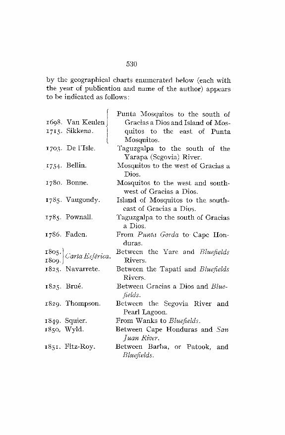
530
by the geographical charts enumerated below (each withthe year of publication and name of the author) appearsto be indicated as follows :
Punta Mosquitos to the south of1698 . Van Keulen Gracias a Dios and Island of Mos -
1 71 5 . Sikkena . quitos
to
the
east
of
PuntaMosquitos .
1703 . De I ' Isle . Taguzgalpa to the south of theVarapa (Segovia) River .
1 754 Bellin . Mosquitos to the west of Gracias aDios .
1780 . Bonne . Mosquitos to the west and south-west of Gracias a Dios .
1785 . Vaugondy. Island of Mosquitos to the south-east of Gracias a Dios .
1785 . Pownall. Taguzgalpa to the south of Graciasa Dios .
1786 . Faden . From Punta Gorda to Cape Hon-duras .
Between the Yare and Bluefields1809 1 Carta Esferica.
1825 . Navarrete . Between the Tapatí and BluefieldsRivers .
1825 . Brué. Between Gracias a Dios and Blue-fields .
1829 . Thompson . Between the Segovia River an dPearl Lagoon .
1849• Squier . From Wanks to Bluefields .1850, Wyld . Between Cape Honduras and San
Juan River.1851 . Fitz-Roy. Between Barba, or Patook, and
Bluefields .