annex a - york a...car borne shoppers car borne commuters and visitors lowest priority hierarchy of...
TRANSCRIPT

- 1 - -
City of York Council Standards & Principles for
Designing Cycling Infrastructure 1.0 INTRODUCTION
1.1 Foreword
This document sets out the standards and principles which are to be used when designing infrastructure for cycling within York and create a consistent approach. Most of the recommendations are taken from DfT Standards and/or Cycling England Guidance, but with some specifics adapted necessarily to fit the uniqueness of the City of York, and also taking into account recommendations made to the Scrutiny Management Committee by an Ad-Hoc Scrutiny Sub-Committee on 23 October 2006 regarding guidance on sustainable development. Furthermore, this document has purposely been kept concise so as to act as a quick reference, as opposed to a detailed parameter guide, as comprehensive design information is already available (listed in the bibliography) and particularly the DfT Local Transport Note 2/08 – Cycle Infrastructure Design (Oct 2008). It would not be possible to incorporate every possible scenario or situation within this document as the permutations are endless, but most of the generic problems/solutions which occur when designing cycling infrastructure will be covered. This document should be used as a general guide (“rule of thumb”) and reference, but in some circumstances, solutions may have to be sought from outside the Design. This is of particular note in conservation areas (many parts of York), where ‘identikit’ solutions are not always appropriate. 1.2 Tips
The three key points to stress to Engineers when designing useful cycling infrastructure are:-
1. Always think from a cyclist’s viewpoint. (e.g. What would really help you on your journey at this point? What would severely deter you? Also what are the Pedestrian movements?
2. Be realistic. (e.g. Is a sign really going to be adhered to? Is it a waste of money?)
3. Use your common sense. (e.g. More often than not, any provision for cyclists is better than none!)
When considering designing infrastructure for cycles, reference should be made to the DfT’s Hierarchy of Users and Hierarchy of Provision, but needs to be considered alongside the environment within which it is going to be built (i.e. traffic speeds; congestion; conservation area; pedestrian numbers; likely type of user; etc). Measures for cyclists (and pedestrians) should offer positive provision which reduces delay or diversion and improves safety:-
Annex A

- 2 - -
Highest Priority
Pedestrians and disabled people Cyclists Public transport users Motorcyclists and taxis Commercial and business vehicles Car borne shoppers Car borne commuters and visitors
Lowest Priority
Hierarchy of Users Hierarchy of Provision
2.0 ON-ROAD PROVISION
2.1 Introduction
Many children and non-confident adult cyclists prefer to use off-road routes as they are separated fully from traffic and are perceived as safer. However, most of the time, the most direct routes for cyclists are those incorporating existing highways, and certainly in York, cycle lanes in the carriageway can benefit most cyclists, although on occasions, poorly designed lanes have made conditions worse or more hazardous. On-road provision also means that the cyclist has priority over vehicles emerging from side-roads, requiring the cyclist to slow down or stop less frequently than most off-road provision. In addition, cycle provision on-road is relatively inexpensive compared to off-road provision and we can usually achieve better value for money this way. Contrary to most motorists beliefs, there is no legal obligation for cyclists to use cycle lanes (or any other type of cycle infrastructure provision), although the benefits of using ‘good’ cycle lanes, for most, outweigh the negatives. The intention is that a cycle lane will create a comfort zone around a cyclist, often assisting them in difficult or congested situations and raising driver awareness of cyclists. However, overly narrow cycle lanes potentially reduce the level of separation between vehicles and cyclists by encouraging cyclists to stay closer to the kerb, and if a lane is too narrow to comfortably ride within it, the purpose of the facility is lost. 2.2 Basics
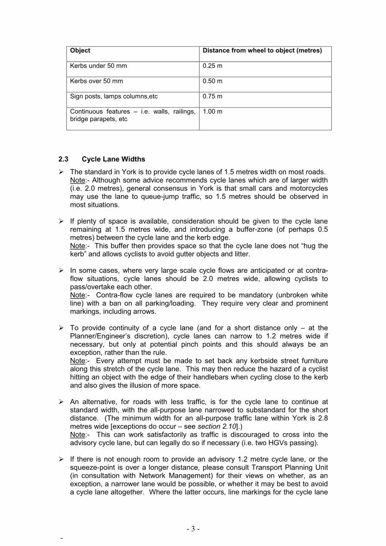
Ø The following minimum clearances should be observed where possible, and increased where there is opportunity. Note:- As a general guide, these figures should be added to the 1.00 m ‘dynamic envelope’ of a cyclist, to give minimum widths of a one-way facility where there are fixed objects:
- 3 - -
Object
Distance from wheel to object (metres)
Kerbs under 50 mm 0.25 m
Kerbs over 50 mm 0.50 m
Sign posts, lamps columns,etc 0.75 m
Continuous features – i.e. walls, railings, bridge parapets, etc
1.00 m
2.3 Cycle Lane Widths
Ø The standard in York is to provide cycle lanes of 1.5 metres width on most roads. Note:- Although some advice recommends cycle lanes which are of larger width (i.e. 2.0 metres), general consensus in York is that small cars and motorcycles may use the lane to queue-jump traffic, so 1.5 metres should be observed in most situations.
Ø If plenty of space is available, consideration should be given to the cycle lane
remaining at 1.5 metres wide, and introducing a buffer-zone (of perhaps 0.5 metres) between the cycle lane and the kerb edge. Note:- This buffer then provides space so that the cycle lane does not “hug the kerb” and allows cyclists to avoid gutter objects and litter.
Ø In some cases, where very large scale cycle flows are anticipated or at contra-
flow situations, cycle lanes should be 2.0 metres wide, allowing cyclists to pass/overtake each other. Note:- Contra-flow cycle lanes are required to be mandatory (unbroken white line) with a ban on all parking/loading. They require very clear and prominent markings, including arrows.
Ø To provide continuity of a cycle lane (and for a short distance only – at the
Planner/Engineer’s discretion), cycle lanes can narrow to 1.2 metres wide if necessary, but only at potential pinch points and this should always be an exception, rather than the rule. Note:- Every attempt must be made to set back any kerbside street furniture along this stretch of the cycle lane. This may then reduce the hazard of a cyclist hitting an object with the edge of their handlebars when cycling close to the kerb and also gives the illusion of more space.
Ø An alternative, for roads with less traffic, is for the cycle lane to continue at standard width, with the all-purpose lane narrowed to substandard for the short distance. (The minimum width for an all-purpose traffic lane within York is 2.8 metres wide [exceptions do occur – see section 2.10].) Note:- This can work satisfactorily as traffic is discouraged to cross into the advisory cycle lane, but can legally do so if necessary (i.e. two HGVs passing).
Ø If there is not enough room to provide an advisory 1.2 metre cycle lane, or the
squeeze-point is over a longer distance, please consult Transport Planning Unit (in consultation with Network Management) for their views on whether, as an exception, a narrower lane would be possible, or whether it may be best to avoid a cycle lane altogether. Where the latter occurs, line markings for the cycle lane

- 4 - -
should merely discontinue for the length of the squeeze-point, and resume when the carriageway returns to normal width. Note:- Some evidence shows that overtaking motorists refer to the lane markings and not the cyclist – meaning some may pass too close if the lane is any narrower. This might be the case on roads with fairly free-flowing traffic. (For narrow roads with traffic which is regularly stationary/queuing, please see section 2.10)
Ø Where space is restricted, consideration should be made to widen the
carriageway and incorporate cycle lanes by removing part of the footway. Note:- This should be done in circumstances where the footway already has very ample width and any narrowing of the footway will not have any adverse effects on pedestrian movements.
2.4 Mandatory / Advisory Cycle Lanes
Ø Research shows that up to a third of motorists do not understand that their vehicles are not permitted to enter, or park within, a mandatory cycle lane (unbroken white line). However, nearly all motorists are aware of the meaning of double yellow lines. It is also apparent that York has many relatively narrow highways where encroachment by motor vehicles (and particularly buses / FTR) into a cycle lane may be unavoidable. Therefore, most cycle lanes installed within York will be advisory (white dashed line) on routes with full parking prohibition (double yellow lines). Note:- Mandatory cycle lanes may be appropriate in some areas where it is felt necessary (and where on-road parking by vehicles is very unlikely – i.e. the outer ring-road), although time constraints should be considered as a TRO is required.
2.5 Diverting Around Parking Bays
Ø Where there are a number of parking bays, the cycle lane should be routed around the bays with a 1.0 metre buffer zone between cycle lane and parked cars to allow for door openings. As a minimum, a buffer zone of 0.5 metres should be used, although this may be influenced by the depth of the parking bay. Note:- Where there is a real danger from parked cars or little room to incorporate the facilities, consideration could possibly be made to divert the cycle lane onto the footway (if wide enough to incorporate segregated use) for a short distance before returning to on-carriageway. Also note though that a buffer zone between cycle track and parking would still be required (doors opening etc) and on-road provision is nearly always the preferable solution.
Example of cycle lane alongside parking bays, with buffer zone.

- 5 - -
2.6 Coloured Surfacing
Ø Anti-skid, coloured surfacing to highlight “cycle accessibility” (in York this is always “FERN GREEN” – RAL 6025 [& Hot-Applied]) will only be used to emphasize the presence of a cycle lane in certain hazardous circumstances to draw motorists’ attention to the potential presence of cyclists.
Ø Consideration should be made to the aesthetics of the scheme and the sensitivity
of the area in which it is being used, as sporadic use of coloured surfacing looks unsightly and it may be better to link some ‘patches’ together (although this may be expensive).
Ø Fern Green surfacing should be used sparingly, but is necessary in the following
situations:-
• At lead-in lanes and advanced stop lines (particularly for non-nearside lanes); • Cycle lanes crossing the mouths of side-roads or alongside parking bays; • Central and right-turn cycle/filter lanes, as well as contra-flow cycle lanes; • At some junctions, particularly where there are exempted cycle movements; • Through zig-zag markings at zebra and pelican crossings and at bus stop
markings (no lining - surfacing only); • Possibly used for 2-way cycle lanes; • Other locations where cyclists may be put at greater risk, e.g. short cycle
lanes through pinch points. Ø Anti-skid, RED coloured surfacing should only be used to highlight a potential
danger for cyclists and should typically only be used for crossings of side-roads etc where the cyclist does NOT have priority. Note:- As a ‘rule of thumb’, Fern Green surfacing should be used where a cyclist has priority or an advantage over other traffic. Red surfacing should be used where a cyclist does not have priority (or if no one user has priority over another).
2.7 Termination of Cycle Route
Ø Where cycle lanes end abruptly on the carriageway, i.e. without any further provision for cyclists, the use of “End of Cycle Route” or “Cyclists Dismount” signs / painted-markings are to be wholly discouraged. If deemed absolutely necessary, only the use of ‘End’ (painted at the termination of a cycle lane) will be acceptable. Note:- In nearly all cases the cycle lane markings should simply discontinue, reintroducing cyclists into the main traffic lane.
2.8 Side Roads
Ø Cycle lanes will be continuous passing the mouths of (minor) side roads. A combination of coloured surface, cycle symbols (diagram 1057 of the DfT’s TSM) – orientated in cyclist direction of travel, occasional arrows (see below), and continuation of lining should be used on the junction itself.
Ø For larger side roads, two symbols should be used - one at the centre of the
traffic lane leaving the side road (an arrow in cyclist direction of travel should also be used here to indicate cyclists crossing from one direction in front of waiting vehicles – where it is deemed necessary), and one at the centre of the traffic lane which enters the side road (no arrow required here).

- 6 - -
Ø For small side roads, the symbol should be placed centrally to the side road ‘mouth’. Usually, an arrow is not required.
Cycle lane passing side road (diag.1057 Diagram 1057. is wrongly positioned and should be centrally positioned to the mouth of this minor side road).
Ø Cycle symbol markings on the ground (diag.1057) must be placed at the start of
any substantial cycle lane and feature at every break (i.e. at a side road – see above), as well as at suitable intervals (at discretion of Engineers). Note:- On any long uninterrupted length of cycle lane, to reduce road markings, diag.1057 can be used sparingly, but would advise symbols approximately every 100-200 metres depending on how prominent these need to be to other road users.
Ø The use of upright signs (diag.967) to denote an on-road cycle lane should be
used sparingly, if at all. York is trying to reduce street-clutter, and with the symbols and any coloured-surfacing on the ground to highlight the facility to road users, these signs serve little purpose. They should be used sparingly around the city, so that where they are used, they are that much more noticed. Note:- If decided that a sign is required in a location, every attempt should be made to attaching it to existing posts/columns.
Diagram 967.

- 7 - -
2.9 Roundabouts
Ø Continental-style roundabouts (also known as compact roundabouts) have tighter geometry than the typical UK roundabout and are more cycle-friendly as motorists are unlikely to attempt to overtake cyclists on the circulatory carriageway due to its limited width. An overrun apron around the central island can offer a tighter geometry for cars by increasing the island’s effective diameter, while still allowing larger vehicles to use the junction. To be most effective, it should be slightly raised and/or textured. Note:- Many studies show there is a higher risk of cyclist injury accidents at roundabouts compared with other junctions. Large, unsignalled, multilane roundabouts are generally the most hazardous and intimidating for cyclists.
Ø Where feasible, roundabouts should be designed for lower vehicle speeds to
allow cyclists to take up a position in the centre of the circulatory carriageway, where motorists are most likely to see them. Entry and exit lanes that are aligned to be more radial than tangential to the circulating carriageway help reduce vehicle speeds by creating greater deflection. Single lane entries and exits ensure that sight-lines are not obscured by other vehicles. Note:- The innovative roundabout at Heworth Green (the ‘magic roundabout’) should be emulated where many cycle routes meet at a common roundabout. These should feature wide cycle lanes, a reduced circulatory carriageway width, tight geometry, and a smaller outside diameter than conventional roundabouts. The lanes only position a cyclist close to the perimeter when he or she intends leaving at the next exit – otherwise, the cyclist is positioned away from the perimeter.
2.10 Cycle By-Passes
Ø Cycle by-passes will be introduced at traffic-calmed areas, particularly at any build-outs, central refuges or chicanes where there would be a danger that the cyclist would get forced out into the main carriageway. Note:- A minimum of 1.0 metre width should be observed for the by-pass. Consideration also needs to be given to issues such as drainage, sweeping and preventing blockage by parked vehicles.
Example of cycle by-pass at a build-out.

- 8 - -
2.11 Where Widths are Restricted / Shared Space (Vehicles & Cyclists)
Ø On single carriageways, where physical space is restricted and there is not enough room to incorporate cycle lanes, nor any off-road alternative, careful consideration should be given to removing the centre line. This has a proven speed-reducing feature as well as re-allocating road space in favour of the cyclist and is best suited to “quiet” locations where there are relatively few HGVs and general traffic flows are reasonably low. Note:- This technique is suitable for roads wide enough to accommodate two 1.5 metre cycle lanes and a central general traffic lane of at least 3.5 metres (i.e. an overall carriageway width of at least 6.5 metres).
Removal of the centre-line and incorporation of cycle lanes. 2.12 ** ONLY IN EXCEPTIONAL CIRCUMSTANCES **:-
v Where situations exist where carriageways are narrow, traffic flows are much greater and there are likely to be periods of stationary queuing traffic (i.e. Gillygate; Lendal Bridge etc), options are extremely limited. Something needs to be done to guide traffic away from the kerb edges and towards the centre line, so that cyclists can then ‘undertake’ queuing traffic. Careful discussions should always be undertaken with Transport Planning Unit (in consultation with Network Management) to agree an acceptable solution. Note:- DfT do not have any recommendations on this situation, other than the use of diag.967 to highlight a recommended cycling route, on-carriageway.
v Because of this lack of guidance from DfT, and with York having a number of
locations where there is a physical lack of space (i.e. overall carriageway widths of less than 7 metres, and no room to convert footway) and often in conservation areas within the heart of York, a special case could be made (only in exceptional circumstances) to install advisory cycle lanes to 1.0 metre width. It is accepted that traffic lanes would be significantly reduced in width (but to an absolute minimum of 2.0 metres wide). As the cycle lanes are only advisory, any vehicles, but particularly HGVs and buses, are legally allowed to enter them and it is accepted that situations will arise when vehicles straddle both the traffic and cycle lanes. Note:- 1.0 metre wide cycle lanes are well below the York standard width (for installing new cycle lanes), but in exceptional circumstances, and for the purpose of allowing cyclists to pass queuing traffic, these could be justified. Please note

- 9 - -
that this option should never be considered as a solution unless all other options have been explored in full.
v In the situation above, as well as the use of lining, the cycle symbol (diag.1057)
should be used more regularly than on normal width cycle lanes (approximately every 25 – 50 metres), to alert other road users that the facility is a cycle lane and to encourage them to stay out of it. Note:- Advisory on-carriageway cycle route signs (diag.967), although normally discouraged from use, may be used in these situations, but only if deemed absolutely necessary and should only be placed at the beginning of the on-road facility and after any major break in the route (i.e. after a crossroads where the facility continues straight ahead). Again, these should be fixed to existing posts/columns if possible.
2.13 Traffic Calmed Areas
Ø If a flat-top speed-table is to be installed, a gentle gradient transition should be used, featuring no overtly sharp angles. Note:- This could be done with the use of preformed sinusoidal profile ramps.
The gentler gradient of a preformed sinusoidal profile ramp.
Ø Where road humps or speed cushions are used, a gap of at least 1.0 metre width needs to provided between kerb-edge and the hump/cushion.
3.0 ADVANCED STOP LINES (‘ASLs’)
3.1 Description
Of all the cycle-specific measures, ASLs are among the most beneficial. However, they must be large and prominent enough to be effective so that motorists do not encroach into the waiting area, as is regularly observed. Importantly, ASLs have little or no negative impact on traffic congestion or capacity, even where a vehicle lane is at saturation flow. However, in some cases the installation of ASLs at a junction may result in a need to make minor changes to the signal timings, mainly for the benefit of cyclists clearing larger junctions, but in most circumstances setting back all the stop lines for other traffic by an appropriate amount to incorporate any ASL will not require a longer inter-green period or any other signal timing changes.

- 10 - -
An example of a standard-width ASL within York. 3.2 Specifications
Ø ASLs must only be used at signalised junctions and must be adequately deep enough for cyclists to make the desired movements and assume a prominent position in the road. These will normally be between 4 and 5 metres deep. Note:- Deeper ASLs are possible where a very large number of cyclists are expected through the junction.
Ø Fern Green coloured surfacing for the waiting area and the lead-in lanes should be used on all ASLs as this can help to make them more conspicuous to motorists who may otherwise encroach upon them. Note:- This is particularly the case with non-nearside lead-in lanes, where cycling between two lanes of vehicular traffic poses an extra hazard.
Ø ASLs should extend across all the traffic lane(s). Part-width ASLs do currently
exist within York, but they are not covered by TSRGD (Traffic Signs Regulations and General Directions) and future part-width ASLs should be avoided or individually authorised internally. Note:- A better solution would be to simply set back the stop-line and signals an extra few metres (so that a full-width ASL can be incorporated).
Ø Lead-in lanes are expected for all ASLs and should be of sufficient length as to
bypass traffic queuing at the signalised junction. The aim should be for the facility to extend back up the road as far as possible, with all options explored to incorporate the lead-in lane (i.e. road widening; traffic-lane width reduction; etc).
Ø For cycle lanes/feeder lanes into advanced stop line arrangements, a width of 1.5
metres is advisable, although 1.2 metres would be acceptable if outbound from a pinch-point. (1.0 metre width would be an absolute minimum if coming from a situation such as in para 2.10, or at a small feeder stub).
Ø Where there is multiple traffic/filter lanes for vehicles to use, and especially at
filter-light arrangements (i.e. Blossom Street crossroads), the use of diag.1057 and arrows on the ASL should be used to indicate the safest position for cyclists to take up where they will not be obstructing filtering traffic movements.
Ø Approval from DfT is currently being sought for the use of advance cyclist signal
lights, for cyclists to be given several seconds ‘head-start’ over other traffic at some junctions where there is a real danger of cyclist/motorist conflict.

- 11 - -
4.0 OFF-ROAD PROVISION
4.1 Introduction
In general, off-road cycle routes in urban areas tend to be the most desired (particularly by non-confident cyclists) however, these are usually the least feasible of options. In practice it is usually more convenient (and cheaper) to cater for urban cyclists on-road if this is practicable. However, off-road provision should be considered first, especially in some cases where there is real or perceived safety issues, or if taking advantage of direct routes (across the Strays for example). This can become apparent when consideration is made of the purpose of a route (i.e. A Safer Route to School might incorporate mainly off-road facilities).
Off-road routes are often created by converting existing footways/footpaths and almost invariably need to be designed to accommodate pedestrians too. Such provision varies considerably from a shared-use pavement alongside an urban road, to countryside leisure routes such as those on converted former railway lines. Overall design will depend very much on how each route is used.
A large problem is that urban off-road routes may be frequently interrupted by side roads. Cycle crossings of side roads can be difficult to get right and they are often points of conflict between cyclists and motorists. Frequent road crossings, tight corner radii, the presence of other users and restricted width or forward visibility all affect the speed with which cyclists can travel and the effort required. Cyclists tend not to favour cycle routes that frequently require them to adjust their speed or stop. 4.2 Basics
Ø Where there is opportunity to incorporate a separate cycle track from a footway, this should normally be observed. A separate, one-directional cycle-only track should be at least 1.5 metres wide. A two-directional cycle-only track should be 2.0 metres wide as a minimum and wider where possible, depending on anticipated usage.
Ø For all shared-use paths, construction should be using an appropriate sealed
surface, and cambered to fall to either side of the centre so that water can run-off to either side and avoids pooling on the path.
Ø In most cases however, shared-use paths are likely to be the most appropriate. 4.3 Segregation -vs- Unsegregation
Ø It is widely acknowledged that shared-use paths are points of conflict between pedestrians and cyclists who use them. Note:- Officers have investigated ways of addressing this problem but have been unable to ascertain a solution other than that offered by the DfT, without causing potential hazards for pedestrians, and/or causing confusion. Furthermore, advice from legal services has specified that to ensure the council is not left liable in the event of an accident, DfT regulations should be followed implicitly.
Ø DfT guidelines do not stipulate when and where segregation should be used over
unsegregation. However it is stated that: “Almost all off-road routes for cyclists are used by pedestrians, and the potential for user conflict needs careful consideration. Where there is potential for conflict, separating user flows is an

- 12 - -
option but if room is limited, this may not be making best use of the width available.”
Ø However, concerning areas where pedestrian and cyclist movements are likely to
conflict, such as at pedestrian crossings or at bus stops, DfT guidance states the following: “If the footway and cycle track on the approach are segregated, segregation should stop short of the waiting area (which should be shared use).”
4.4 Segregated provision
Ø To avoid potential conflict with pedestrians, shared use provision incorporating segregation should be considered in places where there are likely to be high flows of both cyclists and pedestrians. Note:- Cyclists are normally located nearest to the carriageway.
Ø A vertical change in level clearly demarcates the areas for the different users and
is particularly beneficial for those with mobility or visual impairments. (Pedestrians are accustomed to the concept that ‘up equals safe’.) Note:- A level change in these circumstances of 50mm is advisable, using a kerb with a chamfered edge and ideally of a contrasting colour (to make more visible where the level change occurs). Drainage and future sweeping needs careful consideration at these points.
Ø A raised white line (diag.1049.1) should be used in other situations (if level
change cannot be provided or is deemed too expensive to implement), and is the “norm” for segregated provision.
An example of a segregated facility within York. (Note that the Pedestrian symbol shown above is no longer used by CYC on new infrastructure).
Ø Different surfacing (i.e. textures / paving / coloured material) can also be used,
particular in sensitive conservation areas, and which help to keep different users on their side of the facility.
Ø The optimum width for segregated provision (for two-way cycles and pedestrians)
should be between 4.0 and 4.5 metres (2.0 metres for pedestrians and between 2.0 and 2.5 metres for cyclists – allowing bicycles to pass each other with ease).

- 13 - -
Note:- The minimum width for a segregated provision (for two-way cycles and pedestrians) is 3.0 metres.
Ø To provide continuity, (and for a very short distance only), segregated cycle lanes
for one-way cycles and pedestrians can narrow to 2.4 metres wide if necessary (1.2 metres each for cyclists and pedestrians). Note:- In these situations it is likely that pedestrians may encroach onto the cycle-part of the facility.
Ø Minimum clearances (as set out at the beginning of this document) should also
be observed and if necessary added to the path width. Note:- If the facility is immediately adjacent to a 40mph (plus) carriageway, it is recommended to provide a 0.5 metre ‘buffer’ strip.
Ø Signs (diag.957) should be used sparingly (to reduce street-clutter) but may be
required at each end of the section, or after any substantial break (such as after a major junction). Note:- Setting of these signs on bollards, set to one side of the facility, is preferable to erecting a taller, more prominent metal post.
Ø Frequent use of the cycle symbol (diag.1057) painted on the path should be used
to illustrate which side of the segregator is for which user. Note:- Ensure these are painted “the right way around”.
Diagram 957.
Ø Tactile paving is important on paths where there are likely to be high flows of both
pedestrians and cyclists, and particularly benefit the blind and partially sighted. The ribbed (tramline/ladder) surface is used to indicate the start of a shared-use route where cyclists and pedestrians are segregated from each other.
4.5 Unsegregated Provision
Ø The provision of a shared-use path which is unsegregated should be considered in circumstances where there are lower pedestrian/cycle flows and less potential conflicts between the two users (such as in a rural area), or where there is limited width available.
Ø Widths for such paths should be at least 3.0 metres. Ø As a minimum, such paths can potentially go as narrow as 2.0 metres wide, but
only in very quiet locations or in exceptional circumstances. Ø Signs (diag.956) should be placed at each end of the section, and after any
substantial break (such as crossing side roads).

- 14 - -
Note:- Again, avoid erecting too many signs and set them onto bollards if possible.
Diagram 956. 4.6 Where Off-Road Paths Cross ‘Main’ Roads
Ø Generally speaking, where traffic flows (two-way) are judged to be high, a signal controlled (toucan) crossing is required.
Ø Where traffic flows are still high but the provision of a toucan crossing appears
excessive, consideration should be given to providing a zebra crossing at this point. It is not unlawful for cyclists to cycle across zebra crossings but, unlike pedestrians, they do not have priority over traffic. However in most cases, vehicles will naturally give way to someone waiting at a zebra, whether stood waiting, or on a bike waiting. Note:- Suggestions are that a minimum width of 4.0 metres be adopted where cyclists share zebra crossings with pedestrians. To appease the DfT in this case, the use of Cyclists Dismount signs (normally discouraged) can be used at the crossing if felt necessary.
Ø Where traffic flows (two way) are still judged to be substantial but not as high, an
un-controlled crossing can be considered (even on dual-carriageways), with cyclists giving way to general traffic. A central island/refuge may need to be provided, and is advisable on (busy) roads with 3 or more traffic lanes to cross so that the crossing can be made in two movements. The central island/refuge should be a minimum of 2.0 metres depth and a minimum of 2.0 metres wide (but much wider and longer if can be accommodated). Warning signs (diag.950) should be provided on the road approaching the crossing and consideration should be made to the use of coloured surfacing (or keep-clear markings) on the carriageway where the crossing actually is so that queuing traffic does not obstruct the crossing. Note:- Use of diag.1057 on the crossing itself is also advisable.
Diagram 950.

- 15 - -
Ø For crossings such as these, where cyclists do not have priority, the use of Red coloured surfacing should be used. An example of the use of coloured surfacing and cycle symbols to highlight a crossing point.
Ø All crossing points and transitions between surfaces (i.e. cycle path onto road) should be completely flush to the carriageway if at all possible, and with sufficient drainage.
Ø There is also an option to use ‘Elephants Footprints’ (WBM 294) on crossings
such as these in order to define the cycle route across the carriageway and add extra emphasis to the crossing (although the footprints have no legal meaning). Note:- These should be used where it is deemed necessary to make the crossing as prominent to other road users as possible. In some historical quarters or conservation areas, these might not always be appropriate.
WBM 294 – Elephants Footprints. An example of a cycle crossing using (400x400mm, spaced 400mm apart) elephant footprints and coloured surfacing (although in York, for a non-priority crossing,
the surface would be red) 4.7 Where Off-Road Paths Cross ‘Minor’ Roads
Ø Where traffic flows and speeds are judged to be low (i.e. quiet residential streets), or the route crosses the entrances to private driveways, consideration should be made (where appropriate) into providing a priority crossing over the minor road

- 16 - -
with vehicles giving way to cyclists. As standard, this must incorporate a raised crossing (i.e. flat-topped speed table) using coloured surfacing, to highlight the priority crossing. Note:- Giveway markings for motorists should be on the road and good intervisibility between vehicles on the main road and cyclists on the track is essential to enable drivers wishing to enter the side road to judge the speed and positioning of cyclists. Drivers on the main road should be able to see the crossing and cycle track approaches well in advance of the junction.
Ø For crossings such as these, where cyclists do have priority, Fern Green coloured surfacing should be used.
A standard design of a cycling priority crossing over a minor road 4.8 Adjacent-to-Road Cycle Paths
Ø Where adjacent-to-road cycle routes meet a side road, initial consideration should always be given to reintroducing cyclists onto the main road in advance of a junction. Cyclists then pass the junction (with priority) on the carriageway, then rejoin the cycle track.
Reintroduction of the cycle path onto the carriageway, prior to a side road.

- 17 - -
Ø Where this is not possible, the second consideration should be to ‘bend out’ the track. In these circumstances, the track approaches are deflected away from the main carriageway to create a gap of one/two car lengths between the main road and the crossing (i.e. 5.0+ metres). Whether this is done at a priority or a non-priority cycling crossing point, this arrangement allows drivers turning into the side road extra time to notice the crossing and provides somewhere for them to potentially stop for crossing cyclists without obstructing traffic on the main road and also allows a vehicle waiting to exit the side road to do so without blocking the crossing point. Note:- Again, a raised crossing (for cyclist priority crossings), coloured surfacing, keep-clear markings, or potentially elephants footprints should also be implemented.
An example of a ‘bend-out’. Note the use of coloured surfacing to highlight the crossing, although somewhat excessive use of guard-rails.
Ø Crossings can be modified to mitigate hazards to cyclists and pedestrians.
Possible modifications include localised carriageway narrowing with tight kerb radii.
Ø Where cyclists travelling along a busy carriageway need to turn right to join a
cycle track on the opposite side, it may be appropriate to get them to a central refuge via a ‘jug-handle’ turning on the nearside. Note:- Doing this gives cyclists a safe waiting area away from moving traffic and provides good visibility for crossing the carriageway.
Ø Where a right turn is still required, but it is not possible to provide a turning such
as above, cycle refuges (with coloured surfacing) should be implemented within the centre of the carriageway for those cyclists wishing to turn right.
5.0 MISCELLANEOUS
5.1 Road Closures & Turning Restrictions
Ø Where possible, cyclists should always be exempt from road closures and turning restrictions, if safe to do so.

- 18 - -
A cyclist exemption from a road closure, using a road hump.
Ø A short section of road closure or a one-way ‘plug’ (false one-way street) can be used on low speed/flow roads instead of a full contraflow cycle lane and are sometimes preferable as they do not require changes to parking restrictions. Note:- Road Users must be alerted to the movements of cyclists in both directions on the road.
An example of a simple one-way ‘plug’ (in Cambridge). 5.2 Transition between carriageway and cycle path etc
Ø It is important that a cyclists safety and comfort is considered at these transitional points. An upstand crossed at a narrow angle can be hazardous and therefore all transitions between surfaces should always be completely flush, ideally omitting kerbs altogether to provide a continuous surface. Note:- If omitting kerbs is not possible, square edged / inverted kerbs should be used. Drainage provision should always be considered to avoid pooling (and ice in the winter).

- 19 - -
A smooth transition from road to path
Ø Where a dropped kerb at the carriageway is required, this should be wide enough to accommodate cyclists turning at a reasonable speed, with a 4.0 metre minimum radius be assumed when assessing entry angles (for turning cyclists).
5.3 Cycle Signs
Ø Every attempt should be made to mount any necessary signs to existing posts/columns. All post-mounted signs relating to cyclists (directional/warning/informative) should be fixed in a way to prevent rotation (square posts are best for this or the use of anti-rotational clips on standard poles).
5.4 Cycle Barriers
Ø Barriers should not be used unless necessary. Most barriers erected will be to prevent access to a route for motorcyclists (i.e. ‘A’ and ‘K’ barriers), but not impede the way for cyclists and pedestrians. Of course, should barriers be justified, different situations require different types of barrier, so for example a downhill approach to a bridge/underpass may require a chicane to be erected to slow down fast-travelling cyclists for safety reasons. TPU to advise.
Ø Cattle grids can be hazardous to cyclists and CYC Engineering Consultancy are
currently developing a solution to this issue. (Advice to follow at a later date.) 5.5 Cycle Parking
Ø The “norm” is for Sheffield Stands, placed a minimum of 1.0 metre apart from each other, and placed at least 0.6 metres from any wall, parking spaces or road edge.
Ø Wherever possible, stands should be sited in a position which is overlooked or
covered by CCTV, close to a buildings entrance and should be clearly signposted.

- 20 - -
5.6 Maintenance
Ø All facilities for cyclists should be designed with future maintenance needs in mind. Sweeping and drainage are of particular need for consideration.
5.7 Advance Green Signals for Cyclists
Ø Work is currently underway to seek approval from the DfT for the trialing of pre-signal arrangements for cyclists at certain hazardous junctions. Some safety issues arise from cyclists and motorists making conflicting turning manoeuvres and it is strongly felt that this could be mitigated by introducing advance green signals for cyclists (as are standard at junctions in the Netherlands, Denmark and Germany). This would allow cyclists extra time to get a ‘head-start’ from the ASL, ahead of other traffic, whose respective signal would turn green several seconds after the cyclist signal.
6.0 BIBLIOGRAPHY
DfT – Local Transport Note 2/08 – Cycle Infrastructure Design – Oct 2008
http://www.dft.gov.uk/pgr/roads/tpm/ltnotes/ltn208.pdf
Cycling England – Design Checklist & Guidance – Nov 2007
http://www.dft.gov.uk/cyclingengland/engineering-planning/design-checklist/
Nottinghamshire County Council – Cycling Design Guide – Oct 2006
http://www.nottinghamshire.gov.uk/home/traffic_and_travel/traffictravel-cycling/cyclingdesignguide.htm
City of York Council Scrutiny Management Committee – Guidance on Sustainable Development – Oct 2006
http://democracy.york.gov.uk/ieListDocuments.aspx?CId=144&MId=1649&Ver=4
TfL – London Cycling Design Standards – Feb 2005
http://www.tfl.gov.uk/businessandpartners/publications/2766.aspx 7.0 CONSULTEES
Comments from John Grimshaw CBE, Special Adviser to Cycling England
Comments from members of Major Infrastructure Group, Cycling City York Programme
2 Internal CYC Workshops with participation from:- Transport Planning Engineering Consultancy Network Management Highways Maintenance
- 21 - -
Comments from ‘Cycling Champion’ Member
Comments from York Cycle Campaign
Comments from Halcrow Consultancy
Comments from Transport Initiatives Consultancy
Author: Richard Holland Transport Planner – Strategy Directorate of City Strategy City of York Council September 2009