animating dead economics john hoefle sept. 5, 2004 ... · pdf filepage 1 of 15 animating dead...
TRANSCRIPT

Page 1 of 15
Animating Dead Economics John Hoefle Sept. 5, 2004
“And this dam and others like it are as essential to our national strength and security as any military alliance or missile complex.”
John F Kennedy Aug. 17, 1962 Dedication of the Oahe Dam on the Missouri River
Kennedy obviously had some understanding of the role of infrastructure in keeping our nation strong and secure. As had Franklin Roosevelt.
Unfortunately, things have changed. Johnstown Flood May 31, 1889
On May 31, 1889, the town of Johnstown, Pennsylvania, was destroyed by a flood, killing 2,500 people. Johnstown was a thriving steel town of 30,000 people, located at the junction of the Stony Creek and Little Conemaugh rivers. Fourteen miles upstream, on the side of a mountain, was Lake Conemaugh, held in place by the South Fork Dam.

Page 2 of 15
The dam was owned by the South Fork Hunting and Fishing Club, which was the playground of the wealthy and powerful Mellon family of nearby Pittsburgh.
The dam was not in good shape—many residents feared it would fail, and some called it a “sword of Damocles” over their heads, but the oligarchs at South Creek couldn’t be bothered, and refused to fix it.
One day, unusually heavy rains hit the area and the lake began to rise. The club
could have cut a spillway in the dam on one end to relieve the pressure, but instead did nothing. Finally, the dam gave way, sending a wave 75 feet high roaring down on Johnstown, destroying the town, the iron works, and the lives of its citizens.
Even worse, the oligarchs lost their prime fishing lake.
This cavalier attitude toward the common people is typical of the Mellons and their aristocratic peers. Banker Andrew Mellon was Treasury Secretary from 1921 to 1932, and played a major role in the circumstances which lead to the Crash of 1929 and the Depression which followed. His reward was a tour as U.S. Ambassador to Britain, a post normally reserved for powerful Anglophiles. Billy Hitchcock Mellon played a key role in introducing LSD into America, and Richard Mellon Scaife financed the neo-cons’ propaganda assault on the Clinton Presidency. One of the family members, Sir Paul Mellon, was even knighted for his – and the family’s – long service to the British Empire, in opposing the nation-building movement based in Philadelphia.
Marcia has described how the productivity of the nation was increased through land management and infrastructure, draining the swamps, taming the rivers, building railroads.
It is a lesson in physical economy. A lesson we have largely forgotten. WATER

Page 3 of 15
Today, the western United States is five or six years into what the U.S. Geological Survey describes as the worst drought in 500 years. River flows are down dramatically, lakes are drying up, and water shortages range from serious to critical. In some areas, water use is upwards of 150% of local annual precipitation, and large areas in the western half of the country have water usage between 100% and 150% of annual rainfall. These areas are increasingly dependent upon water imported from other areas, water which is increasingly not available. Given that this is the fastest-growing region of the country, these water shortages will only worsen.
A recent study by the State of Colorado says that the state’s water needs will increase by 50% by 2030, and that the state can come up with 90% of that water only by spending billions of dollars on water projects, water recycling and rationing, and cutting off water for farmland irrigation. Those Draconian measures still leave a 10% shortfall.
The situation in Las Vegas, which wouldn’t even exist if not for FDR’s Colorado River project, is critical. Water levels in the Colorado are at a 100-year low, and Lake Mead is only half full. The Southern Nevada Water Authority is already paying residents not to grow lawns, and Las Vegas will likely declare an official water emergency by the end of the year. Greening the desert is a good idea, though Las Vegas is not the best example of the concept. We had a plan to do this, the North American Water and Power Alliance, which would have already been built and providing water, had it not been shelved in the 1960s. We had a way to increase the water supply to the west by 25%, but it was shelved as a expensive boondoggle. But NAWAPA, in the long run, would have cost nothing. In addition to saving the enormous costs coming from the water shortages, it would have made the western lands more productive. Great infrastructure projects like NAWAPA actually create wealth in the long run.
There were also plans on the drawing boards for desalination of water, turning seawater into potable water. The U.S. Department of the Interior had an Office of Saline Water, but it was shut down. The California Metropolitan Water District had plans for nuclear desalination plants in the Pacific to deal with its water problems, but these were also shelved.

Page 4 of 15
President Dwight Eisenhower said in 1953 that “Experts would be mobilized to apply atomic energy to the needs of agriculture, medicine and other peaceful activities… [and] provide abundant electrical energy to the power-starved areas of the world.”
Nuclear power represented the opportunity for mankind to make a great technological leap, to an era of safe, cheap and virtually unlimited power, which would transform the world in which we live. Nuclear power could provide the energy for widespread desalination and abundant electricity, paving the way for cleaner and more efficient industrial processes, high-speed magnetic-levitation transportation, and a host of other scientific breakthroughs.
Faced with that prospect, large numbers of nuclear reactors were planned. Ultimately, 104 were built, and today those reactors provide about 20% of the electricity we use. But those plants are aging, nearing the end of their lives. Many of the plants on the drawing board, and some actually under construction, were cancelled.
Nuclear power was demonized through an intense propaganda campaign, and
instead of abundant nuclear power, we got Enron. Instead of a science driver to take the world to new levels, we got a descent into rentier-financier looting. AGRICULTURE
Page 5 of 15
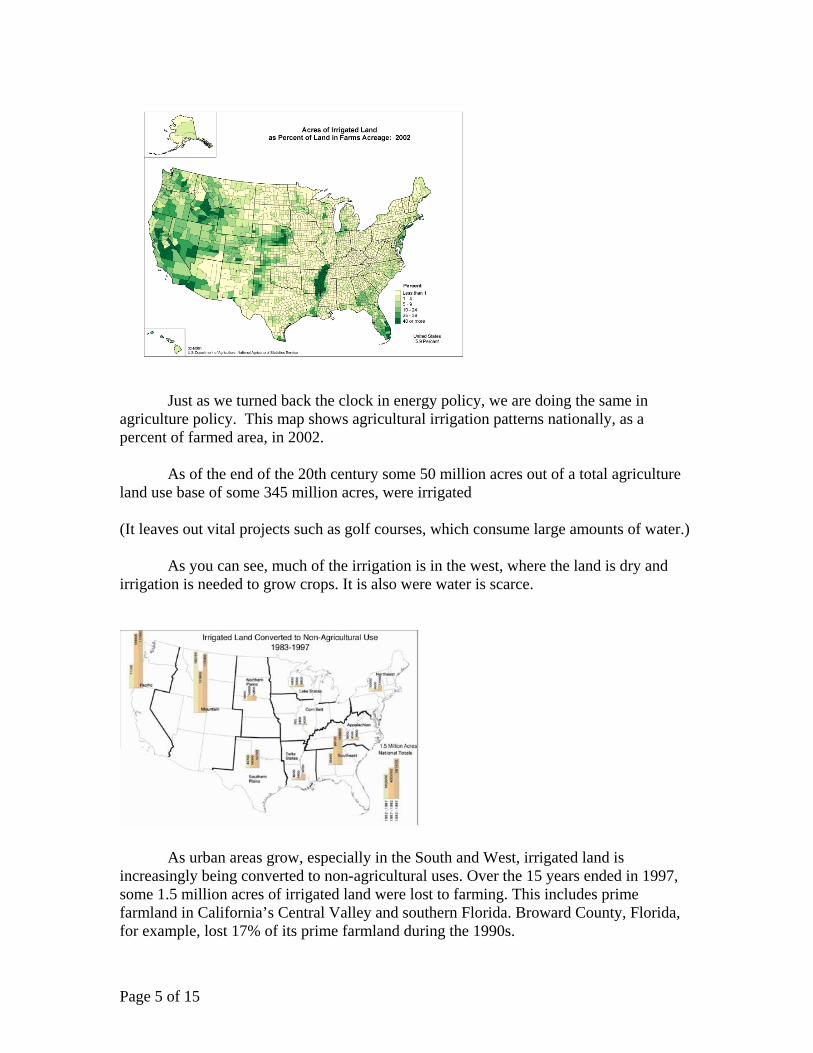
Just as we turned back the clock in energy policy, we are doing the same in agriculture policy. This map shows agricultural irrigation patterns nationally, as a percent of farmed area, in 2002.
As of the end of the 20th century some 50 million acres out of a total agriculture
land use base of some 345 million acres, were irrigated (It leaves out vital projects such as golf courses, which consume large amounts of water.)
As you can see, much of the irrigation is in the west, where the land is dry and irrigation is needed to grow crops. It is also were water is scarce.
As urban areas grow, especially in the South and West, irrigated land is increasingly being converted to non-agricultural uses. Over the 15 years ended in 1997, some 1.5 million acres of irrigated land were lost to farming. This includes prime farmland in California’s Central Valley and southern Florida. Broward County, Florida, for example, lost 17% of its prime farmland during the 1990s.

Page 6 of 15
This map shows the areas which have been hit the hardest. Each red dot represents 2,000 acres of cropland taken out of service, while each green do represents 2,000 acres put into service. The green dots are hard to see, but that’s okay, because there aren’t that many of them.
Overall, over 18 million acres of farmland were taken out of agricultural service between 1982 and 1997.
That’s no problem, of course, because under globalization we can import the food we no longer produce, from other nations. Except for the fact that it is killing our economy and taking food from nations that need it for their own people, there’s no downside. To paraphrase Bertrand Russell: that might be unpleasant, but so what?

Page 7 of 15
Wreaking even more havoc on our agricultural sector is the movement to place land in “conservation reserves” and restore “wetlands.”
“Wetlands”, of course, is a politically correct euphemism for swamps. We went to
a lot of trouble to drain these swamps and make the land productive, but now we’re reversing course. But “restoring wetlands” sounds a lot better than “creating swamps.”
Each dot on this map represents 5,000 acres of land put into “conservation reserves” or reverted to “wetlands.” Some 33 million acres—nearly one-tenth of the agriculture base—is in this “back to nature” program.
This represents a fundamental assault on the land-use improvements which turned the U.S. into a breadbasket for the world. Starting with the Environmental Policy Act of 1969, and the Water Bank Act and Earth Day in 1970, the concept of land management has been replaced with the romantic idea that the land should be free from human interference, and that the rivers should be free to flow as they wish, unencumbered by dams and flood-control measures.
Here are a couple of examples of the effects of that policy. The first is a brand new swamp at Spunky Bottoms on the Illinois River. This is officially called “floodplain restoration”, but it is actually swamp-building. Many of the people who live near these new swamps also call it mosquito farming. But hey, mosquitos have rights, too!
Page 8 of 15
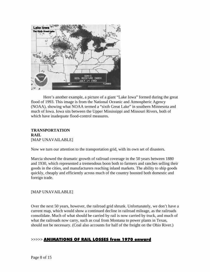
Here’s another example, a picture of a giant “Lake Iowa” formed during the great flood of 1993. This image is from the National Oceanic and Atmospheric Agency (NOAA), showing what NOAA termed a “sixth Great Lake” in southern Minnesota and much of Iowa. Iowa sits between the Upper Mississippi and Missouri Rivers, both of which have inadequate flood-control measures. TRANSPORTATION RAIL [MAP UNAVAILABLE] Now we turn our attention to the transportation grid, with its own set of disasters. Marcia showed the dramatic growth of railroad coverage in the 50 years between 1880 and 1930, which represented a tremendous boon both to farmers and ranches selling their goods in the cities, and manufacturers reaching inland markets. The ability to ship goods quickly, cheaply and efficiently across much of the country boosted both domestic and foreign trade. [MAP UNAVAILABLE] Over the next 50 years, however, the railroad grid shrunk. Unfortunately, we don’t have a current map, which would show a continued decline in railroad mileage, as the railroads consolidate. Much of what should be carried by rail is now carried by truck, and much of what the railroads now carry, such as coal from Montana to power plants in Texas, should not be necessary. (Coal also accounts for half of the freight on the Ohio River.) >>>>> ANIMATIONS OF RAIL LOSSES from 1970 onward

Page 9 of 15
Between 1980 and 2002, the mileage of Class I railroads shrank by 40%. In 2003,
coal accounted for 44% of the freight on the Class I railroads, compared to 8% for farm products.
In 1997, a shortage of rail capacity emerged on the Gulf Coast and spread nationwide during 1998, in what an official of the Society of the Plastics Industry called “a multi-billion-dollar national disaster and the worst rail crisis of this century.”
Faced with increasing delays in shipping times, and a shortage of rail cars, many shippers turned to trucks and waterborne transportation to move their goods. The rail system remains a mess to this day, and that doesn’t count the abysmal state of passenger rail.
The whole system needs to be rebuilt with mag-lev.
NAVIGATION
The U.S.’s system of inland navigable waterways is one of our economy’s great
assets, and like most of our infrastructure, that essential system is rapidly deteriorating.
The Ohio River begins in Pittsburgh, at the confluence of the Allegheny and Monongahela rivers, and ends 981 miles downstream at Cairo, Illinois, where it empties

Page 10 of 15
into the Mississippi River. At its origin, the river is 710 feet above mean sea level, and Cairo it is 250 feet above sea level, a drop of 460 feet. Lock and Dam Number One on the Ohio River was opened at Emsworth just downstream from Pittsburgh in 1921, replacing the original wicket dam completed in 1885. Today, there are 20 locks-and-dams on the river, and nearly a quarter of them are beyond their 50-year engineering lifespan.
The navigable section of the upper Mississippi River falls even further, from 800 feet above sea level near Minneapolis-St. Paul, to 250 feet when it meets the mouth of the Ohio River 900 miles later. 29 locks and dams have been built on the Upper Mississippi.
The Illinois Waterway connects the Mississippi River with Lake Michigan. It consists of the Illinois River, the man-made Upper Illinois Waterway, the Des Plaines River and the Chicago River. A series of 8 locks and dams are used to maintain navigability.

Page 11 of 15
There are nine dams on the Tennessee River between Knoxville and Paducah, all run by the TVA, each with a lock maintained by the U.S. Army Corps of Engineers. During that 652-mile stretch, the Tennessee falls 350 feet, then empties into the Ohio.
None of these rivers would be navigable were it not for the dams, which turn each river into a series of pools, and locks, which permit river traffic to move from one pool to another. This diagram shows how a lock works.
Page 12 of 15
With these locks so essential to our inland waterborne commerce system, any breakdown would have immediate repercussions. For example, in May, the Army Corps found cracks in the main gate of the 1,200-foot-long McAlpine lock on the Ohio River in Louisville, Kentucky. This presented a major problem, since the second lock at McAlpine, a 600-foot lock, was already shut down, being replaced with a second 1,200-foot lock in a long-delayed project. With no redundancy, shutting down the McAlpine lock effectively meant shutting down the entire Ohio River system to through traffic. To minimize disruption to an already strained transportation system, the Corps issued notices and waited until August to shut the lock down and repair the main gate. The McAlpine lock was down for two weeks for repairs, in which workers welded steel patches over the foot-long cracks in the 70-foot-hig lock gates.
Emergency repairs have also been necessary at four locks on the Upper Mississippi, as gates left in service long past their design lifespan crack from metal fatigue.
At the same time, some locks are in such bad shape due to neglect from lack of funding, that they may have to be closed. This includes a lock on the Kaskaskia in southern Illinois, four locks on the Oachita/Black River in Arkansas and Louisiana, and the Willamette River in Oregon. INDUSTRY AND LABOR
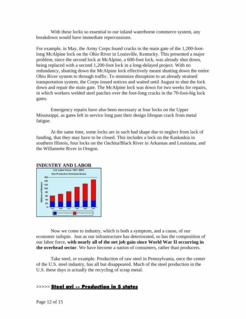
Now we come to industry, which is both a symptom, and a cause, of our economic tailspin. Just as our infrastructure has deteriorated, so has the composition of our labor force, with nearly all of the net job gain since World War II occurring in the overhead sector. We have become a nation of consumers, rather than producers.
Take steel, or example. Production of raw steel in Pennsylvania, once the center of the U.S. steel industry, has all but disappeared. Much of the steel production in the U.S. these days is actually the recycling of scrap metal. >>>>> Steel avi -- Production in 5 states

Page 13 of 15
Now look at the aluminum industry in the Northwest, where it prospered due to
the cheap electricity from the hydroelectric dams on the Columbia River system. Manufacturing aluminum requires a lot of power, and the combination of the drought and the manipulations of the Western energy markets by Enron and its fellow pirates, led to the shutdown of several plants in the Northwest in recent years. Kaiser found that it could make more money reselling electricity it bought from the Bonneville Power Administration during the electricity crisis, than it could make by using that electricity to make aluminum. >>>>> Aluminum in the Northwest
Under the Bush Administration, the U.S. manufacturing sector, as measured by employment, has fallen off the cliff. We’ve lost some 2.5 million manufacturing production workers, reflecting both the depressed economy and the headlong rush by U.S. and other manufacturers to ship production jobs overseas in a short-sighted attempt to save money. We are now back below the levels of the 1950s. And these are in absolute numbers, in a rising population. The per capital numbers would be even worse.
Look at the relationship between the decline in manufacturing jobs, population and the poverty rate in 15 industrial cities in Ohio and Pennsylvania over the past three decades. And these are the official statistics. The truth is significantly worse.
Page 14 of 15
The loss of manufacturing jobs leads to a decline in population and an increase in the poverty rate. The Midwest, once one of the most productive areas of the world, is turning into a poverty zone.
The very means of our existence is being destroyed. FARMERS
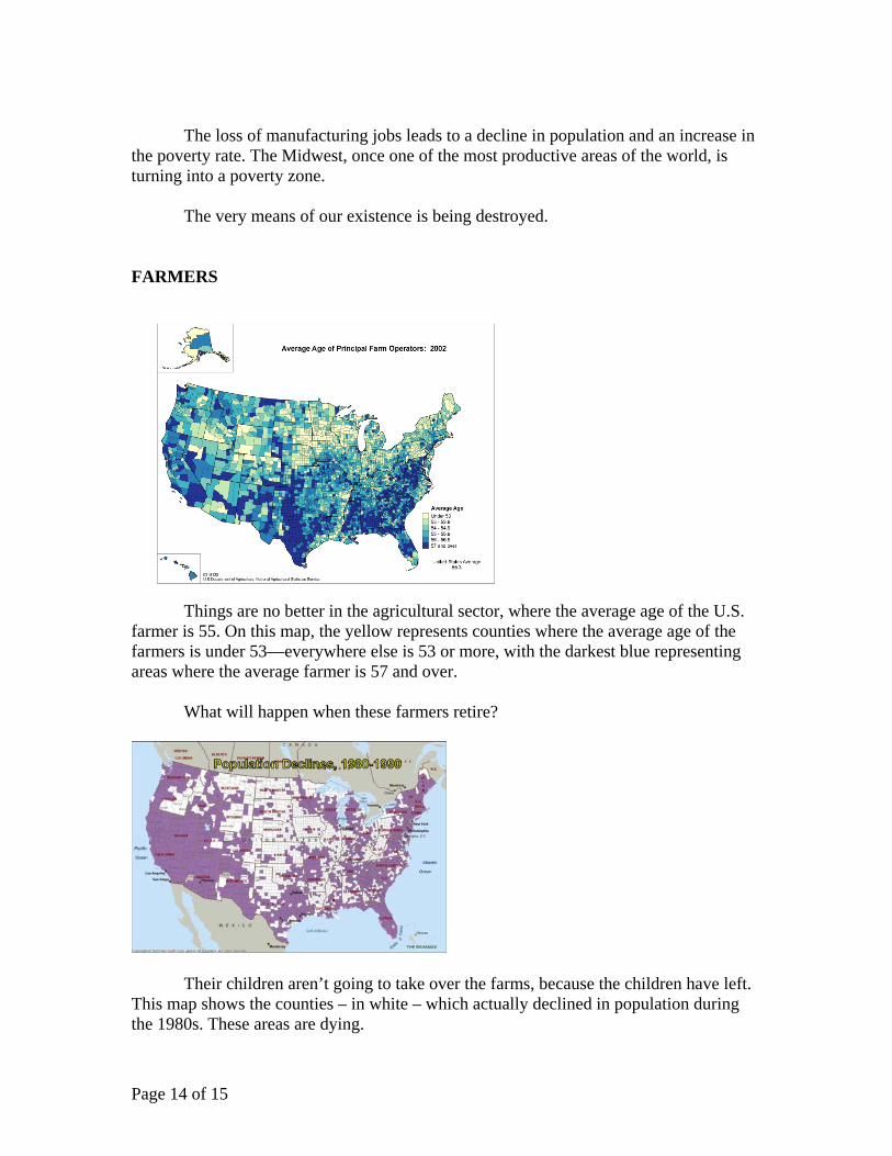
Things are no better in the agricultural sector, where the average age of the U.S.
farmer is 55. On this map, the yellow represents counties where the average age of the farmers is under 53—everywhere else is 53 or more, with the darkest blue representing areas where the average farmer is 57 and over.
What will happen when these farmers retire?
Their children aren’t going to take over the farms, because the children have left. This map shows the counties – in white – which actually declined in population during the 1980s. These areas are dying.

Page 15 of 15
Our last slide is an omen of the future. It shows a temporary gate being hoisted into position, in the lower gates of the main chamber at Lock and Dam 15, on the Mississippi River, in Rock Island, Illinois. This temporary gate replaces the cracked main gate, which was sent off-site to repair cracks in the metal. The significance of this event, which occurred Aug. 21, is that it is the last temporary gate the Army Corp has available, for emergency use on the Mississippi. That’s how close to the edge, this system is operating.
This is real economics, and it is a frightening picture. The U.S. economy is in a breakdown crisis in virtually every sector, from production to power to transportation to health care and education. Under this geometry, there is no hope of a recovery. The only way to turn this disaster around is through the principle of LaRouche’s “Super TVA,” a government-credit-financed emergency development program. We need to give the financier-speculators a flea-dip, and return to sound economics. In that vein, we close with a project which embodies the spirit of what can be done, what must be done, what we at this conference must make happen. >>>>> NAWAPA movie 2 minutes