android applications for gnss - csisdinesh/gnss_train_files/202001... · android application for...
TRANSCRIPT


Android Applications for GNSS
1. RtkDroid
2. SW Maps

RtkDroid• For RTK positioning using low-cost receivers.
• RtkDroid uses correction data from NTRIP casters (in RTCM3 format)
• Uses RTKLIB 2.4.3b33 for RTK positioning.
• Corrected position output of RtkDroid can be used by SW Maps for data collection
• Sets location of Android device using a mock location provider so all other apps use RTK positioning
• For installation files and more information, contact Dr. Dinesh Manandhar at [email protected]
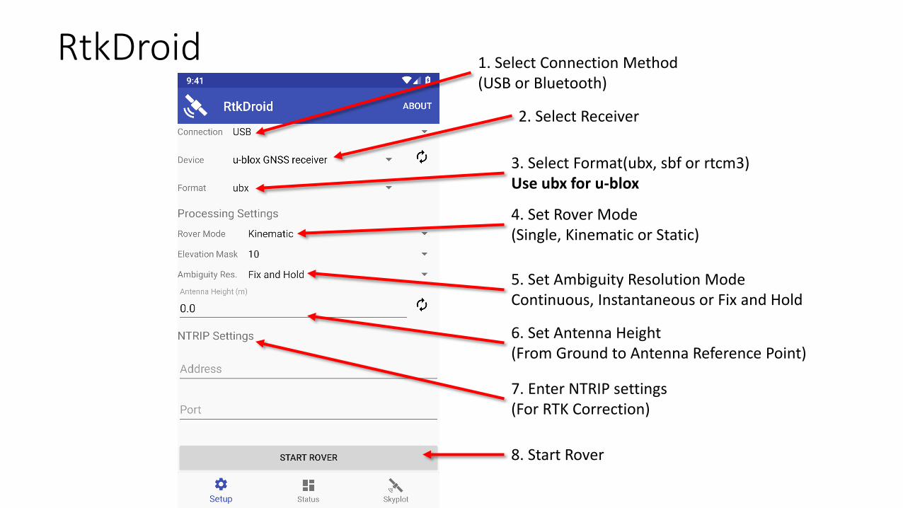
1. Select Connection Method(USB or Bluetooth)
2. Select Receiver
3. Select Format(ubx, sbf or rtcm3)Use ubx for u-blox
4. Set Rover Mode(Single, Kinematic or Static)
5. Set Ambiguity Resolution ModeContinuous, Instantaneous or Fix and Hold
6. Set Antenna Height(From Ground to Antenna Reference Point)
7. Enter NTRIP settings(For RTK Correction)
8. Start Rover
RtkDroid

Press this button to start/stop recording
Records solution as NMEA and logs receiver raw data input

SW Maps
• Free Android Application for collecting, presenting and sharing geographic information
• Can be used for large scale GNSS surveys to collect detailed attribute information or just to display popular GIS data formats on Android
• Downloaded more than 180,000 times by users all over the world

Features
• Collect data using internal and external GNSS receivers (Bluetooth or USB). Connect RTK capable receivers for high accuracy surveying.
• Import and display popular GIS Data formats (GeoPackage, KML, Shapefiles, GeoJSON, MbTiles)
• Google Maps or OpenStreetMap as background; Can also import and cache maps from online sources (WMS, XYZ Tiles)
• Record tracks and photos.
• Export or share collected data directly to KMZ, Shapefiles, GeoPackage, GeoJSON and many other formats.
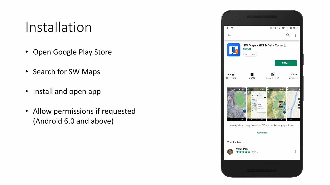
Installation• Open Google Play Store
• Search for SW Maps
• Install and open app
• Allow permissions if requested (Android 6.0 and above)
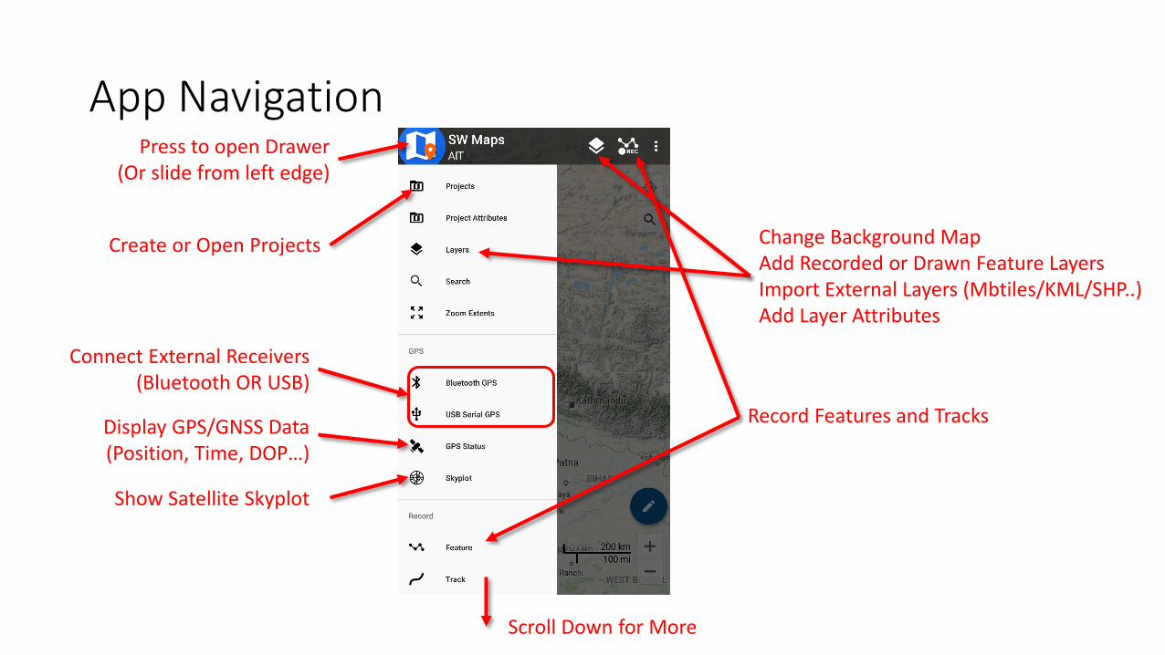
App Navigation
Connect External Receivers(Bluetooth OR USB)
Change Background MapAdd Recorded or Drawn Feature LayersImport External Layers (Mbtiles/KML/SHP..)Add Layer Attributes
Display GPS/GNSS Data(Position, Time, DOP…)
Create or Open Projects
Show Satellite Skyplot
Record Features and Tracks
Scroll Down for More
Press to open Drawer(Or slide from left edge)
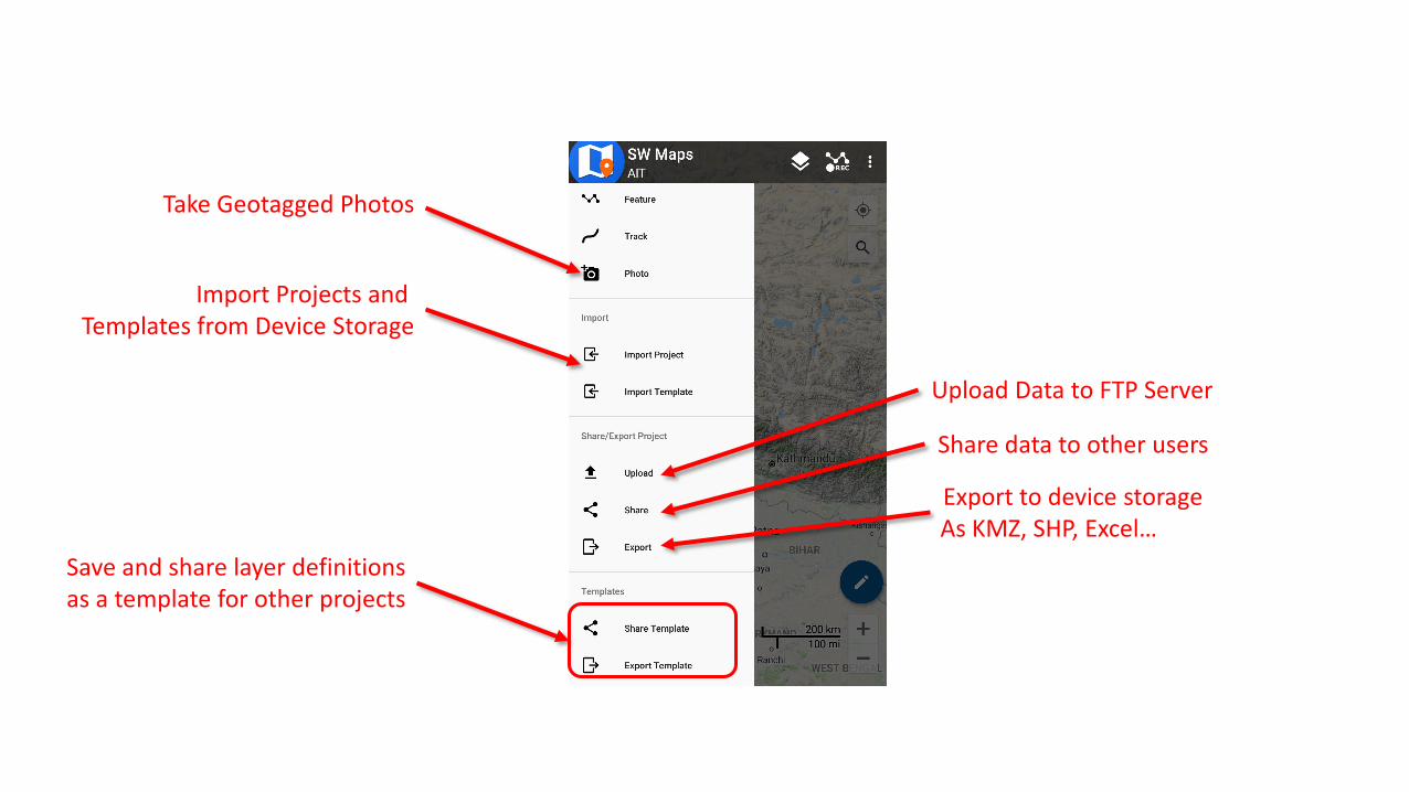
Take Geotagged Photos
Import Projects and Templates from Device Storage
Share data to other users
Upload Data to FTP Server
Export to device storage As KMZ, SHP, Excel…
Save and share layer definitionsas a template for other projects

SW Maps Folder
Copy GIS Data files (Mbtiles, KML, SHP, GeoJSON…)to import here, inside format
specific sub-folders
Project files saved here
All exported files saved here
RAW GNSS Data (UBX, SBF..)
Photos and Videos taken by
SW Maps
Copy project templates here

Drone Imagery Mbtiles Shapefile Categorized Styling
Exported KMZ in Google Earth
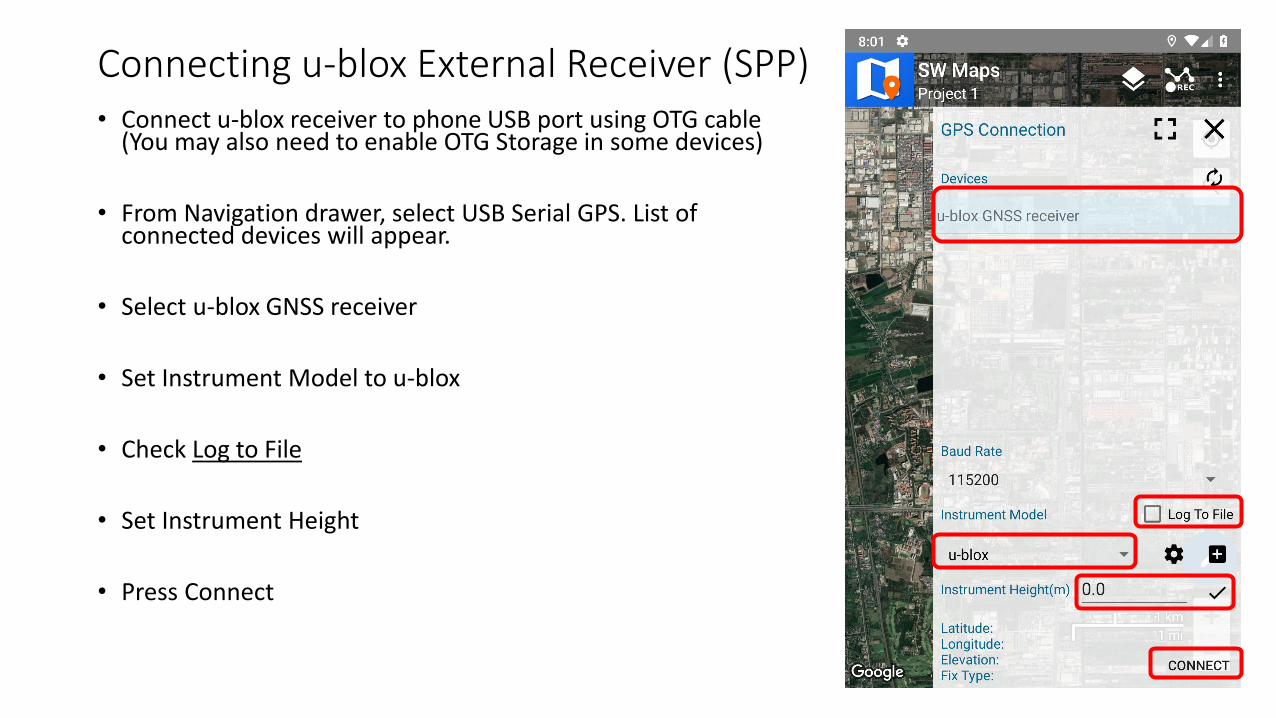
Connecting u-blox External Receiver (SPP)• Connect u-blox receiver to phone USB port using OTG cable
(You may also need to enable OTG Storage in some devices)
• From Navigation drawer, select USB Serial GPS. List of connected devices will appear.
• Select u-blox GNSS receiver
• Set Instrument Model to u-blox
• Check Log to File
• Set Instrument Height
• Press Connect

Connecting u-blox External Receiver (RTK)• RTK is supported with the u-blox M8P and
F9P
• Set Instrument Model to u-blox RTK and Connect
• Open NTRIP Connection from the navigation drawer
• Enter NTRIP caster information and press Connect.

Connecting Other GNSS Receivers
• Instrument profiles are provided for many receivers
• Profiles can be created for your receiver if you know the setup commands.
• Alternatively, setup your receiver to output NMEA to serial port or Bluetooth, and use Generic NMEA profile when connecting.
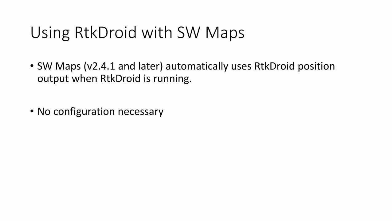
Using RtkDroid with SW Maps
• SW Maps (v2.4.1 and later) automatically uses RtkDroid position output when RtkDroid is running.
• No configuration necessary

GNSS Data and Skyplot
• Raw GNSS data files are saved in SW_Maps/RawFiles Folder

RTK in Android: Summary
For Data Collection with SW Maps:• u-blox M8T: Use RtkDroid for RTK, connects automatically with SW Maps
• u-blox M8P, F9P: Connect from SW Maps with u-blox RTK profile, then set NTRIP Settings in SW Maps
• Other receivers: Use one of the built-in instrument profiles, or setup receiver to output NMEA and use the Generic NMEA profile.
For Data Collection with Other Apps, set up RtkDroid as a Mock Location Provider in Android Developer Options

Layers1. Press to open Layer sidebar
2. Change Background Layer
3. Press + to add layer
4. Select Layer Type(We will add a GPS Recorded Feature layer for recording features using GNSS)
Maximize/Close Sidebar
Toggle Track and Photo Point Layers

Add GPS/GNSS Recorded Feature Layer
Enter Layer Name
Geometry Type (Point, Polyline or Polygon)
Change Map Symbol
Then Add Layer
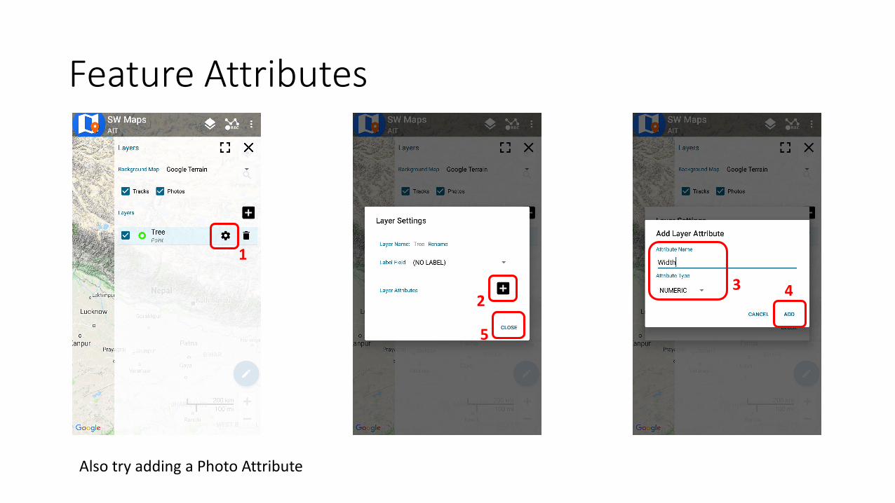
Feature Attributes
1
32 4
5
Also try adding a Photo Attribute

Record FeatureSelect Layer
Type in feature remarks (if required)
(Photos can only be taken after recording the feature)
Enter Attribute Data
Record PointEnable/Disable Location Averaging

Drawing Features1. Add a Drawn Feature Layer
Name: AreaType: Polygon

Drawing Features
1. Open Draw Menu
2. Add Feature
3. Feature Name
4. Press to Add
5. Press Add Point
6. Tap on map to add vertices
7. Press to Close
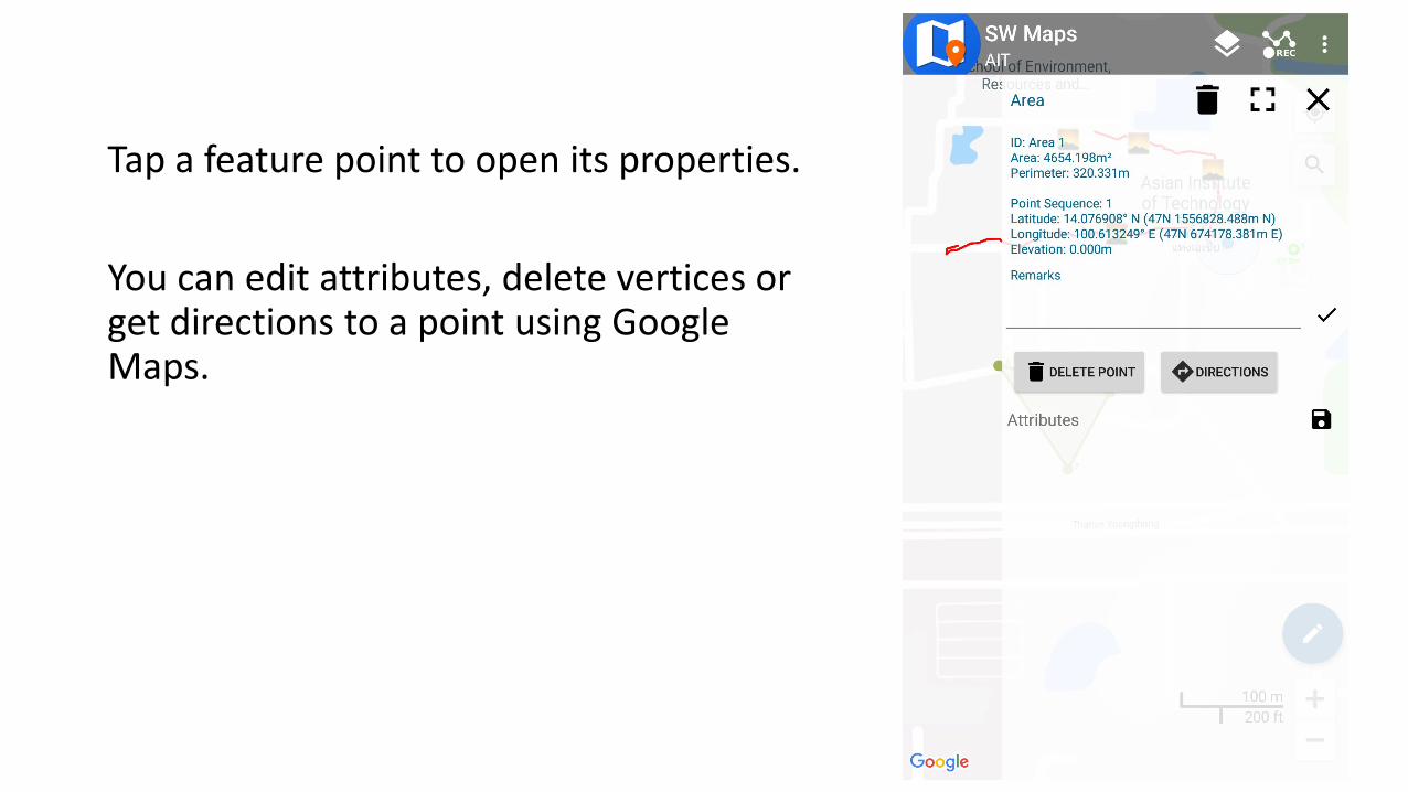
Tap a feature point to open its properties.
You can edit attributes, delete vertices or get directions to a point using Google Maps.
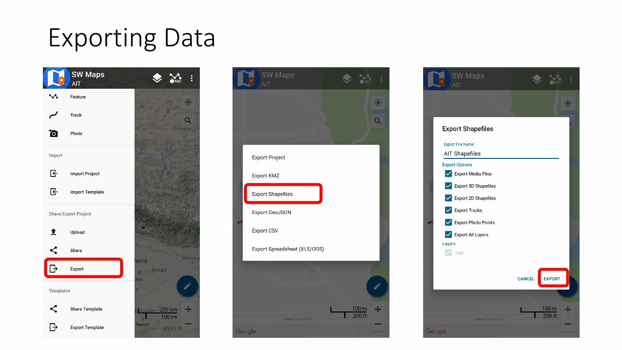
Exporting Data

Things to Try
• Record a Line Feature• Record a Polygon• Add an Options Attribute Field (Dropdown choices)• Edit attributes after saving feature (Hint: Tap the feature on map)• Take a Photo Point (Select Photo from drawer)• Record a track• Export data to KMZ, copy to computer and open in Google Earth• Measure length and area by drawing lines and polygons

Templates
• Projects once created can be exported as a template for other projects.
• Useful when many surveyors and instruments are deployed to collect the same type of data
• Templates can be made on a Windows PC using the SW Maps Template Builder tool, or exported from any existing project using SW Maps
http://swmaps.softwel.com.np/template_builder

Template Builder

SW Maps Applications
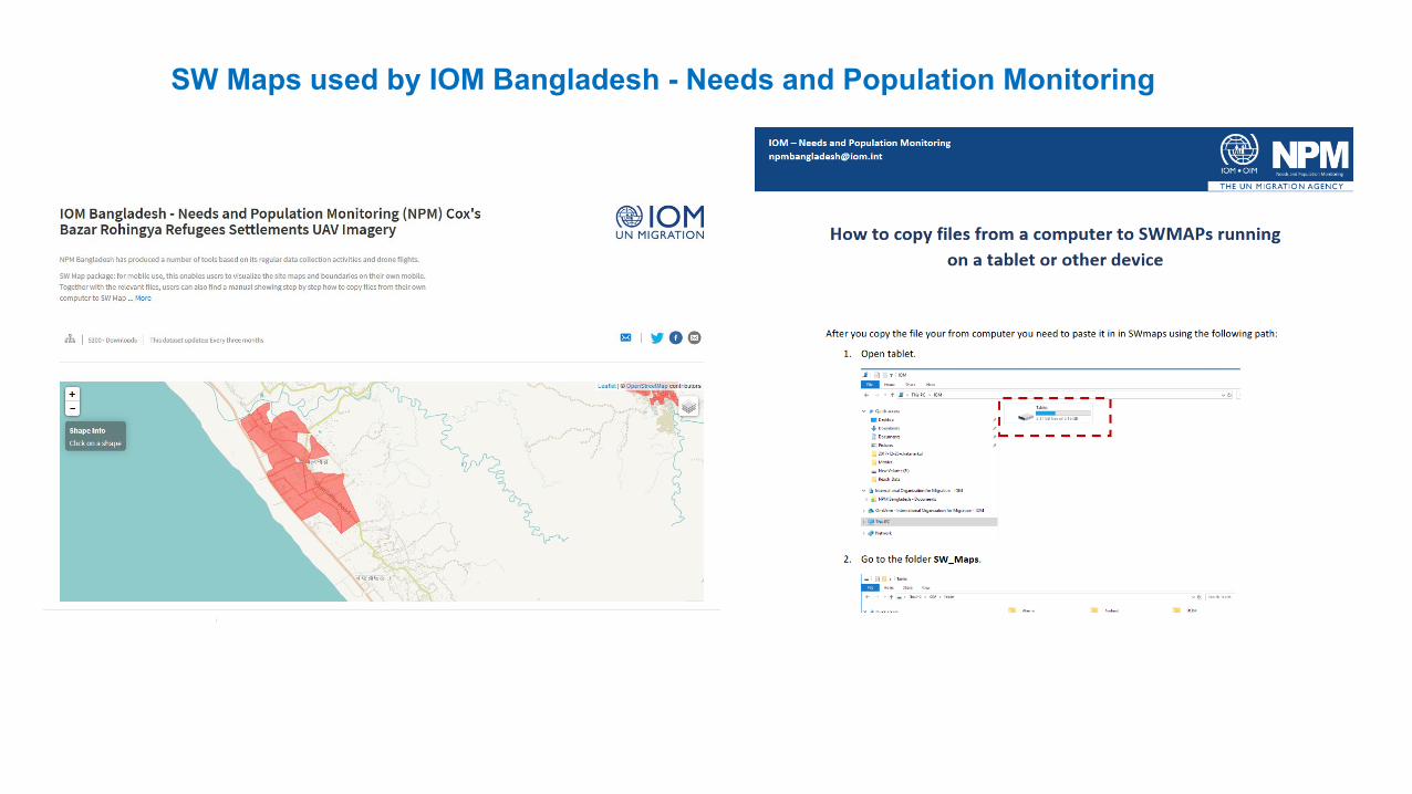
SW Maps used by IOM Bangladesh - Needs and Population Monitoring

SW Maps Use for 2020 Census in Indonesia

SW Maps Training by Bhutan GIS Society

Construction Monitoring of Water Supply Works in Kathmandu Valley
SW MAPS used for Data Capture• Web Based System with open source software
• Centralized PostgreSQL Database
• Web Interface for Data Query and Geometry Editing
• Details of Construction Progress
• Map Overlay
http://wnms.softavi.com
• SW MAPS was used for Survey of completed and ongoing works
• Uploading to server with photographs
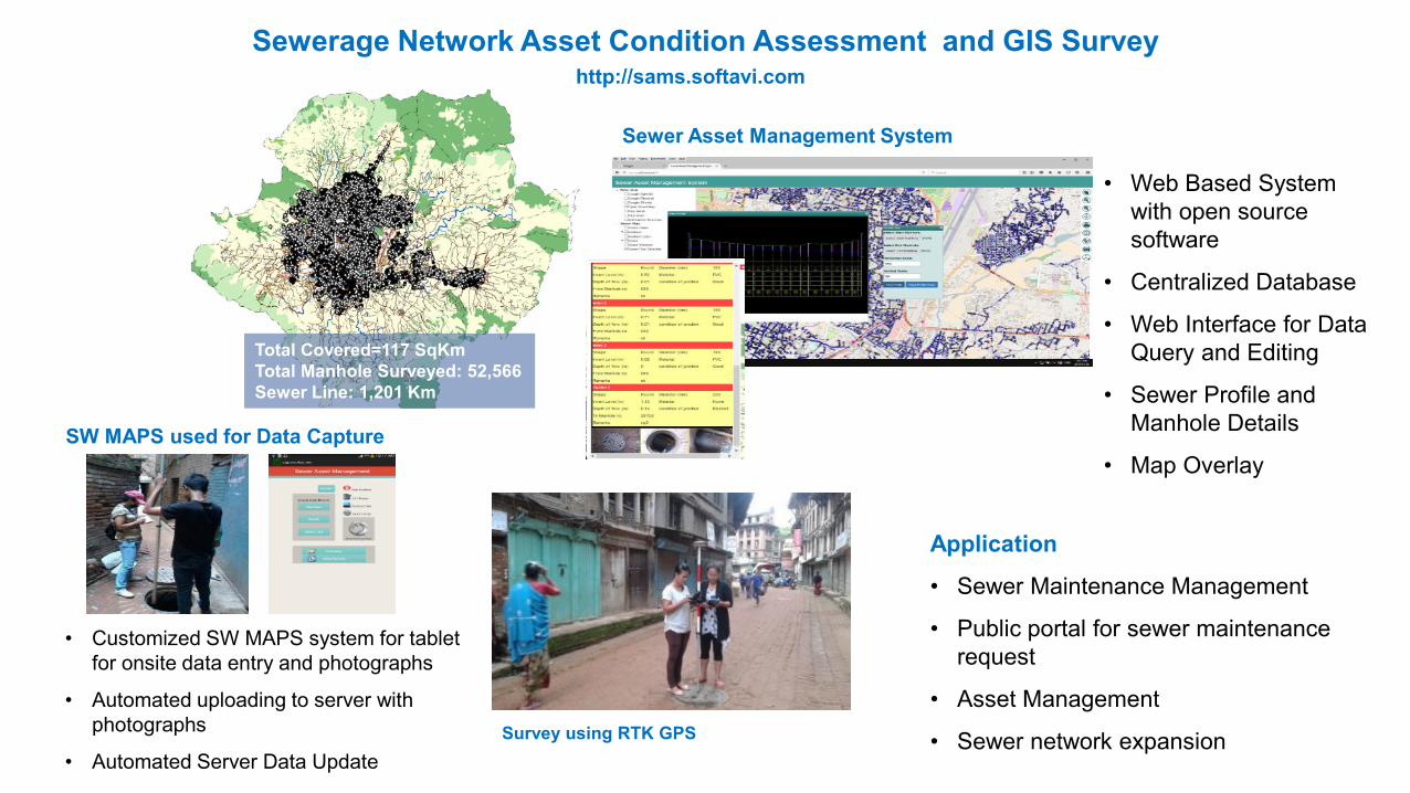
Sewerage Network Asset Condition Assessment and GIS Survey
Total Covered=117 SqKmTotal Manhole Surveyed: 52,566Sewer Line: 1,201 Km
SW MAPS used for Data Capture
• Customized SW MAPS system for tablet for onsite data entry and photographs
• Automated uploading to server with photographs
• Automated Server Data Update
Sewer Asset Management System
• Web Based System with open source software
• Centralized Database
• Web Interface for Data Query and Editing
• Sewer Profile and Manhole Details
• Map Overlay
Survey using RTK GPS
Application
• Sewer Maintenance Management
• Public portal for sewer maintenance request
• Asset Management
• Sewer network expansion
http://sams.softavi.com

Community Water Supply Information
Total Covered 5 Districts of Nepal
SW MAPS used for Data Capture• SW MAPS was used for Survey of
completed water supply works
• Survey of unserved Community and potential water sources
• Uploading to server with photographs
• Web Based System with open source software
• Centralized PostgreSQL Database
• Web Interface for Data Query and Geometry Editing
• Details of Water Supply Projects
http://careims.softwel.com.np

Small Irrigation Project
Total Covered = 9 Districts Total Project Surveyed: 1200 (till now)
SW MAPS used for Data Capture
• SW MAPS was used for Survey works.
• Uploading to server with photographs
• Editing of Geometries in Server
• Web Based System with open source software
• Centralized PostgreSQL Database
• Web Interface for Data Query and Geometry Editing
• Irrigation Details
• Map Overlay
http://sipnepal.org
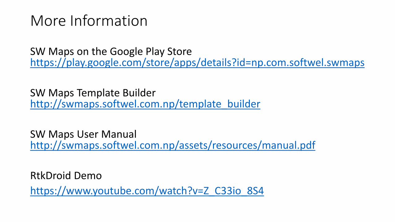
More Information
SW Maps on the Google Play Store https://play.google.com/store/apps/details?id=np.com.softwel.swmaps
SW Maps Template Builderhttp://swmaps.softwel.com.np/template_builder
SW Maps User Manualhttp://swmaps.softwel.com.np/assets/resources/manual.pdf
RtkDroid Demohttps://www.youtube.com/watch?v=Z_C33io_8S4