and cultural heritage the alas sites – geography, …location, climate and topography figueira da...
TRANSCRIPT

Lesvos, with 87,151 inhabitants and an area of
1,636 km2, is the second largest island in the Ae-
gean after Crete. Even today the island has a tra-
ditional rural character, with little industry (olive
groves, fishing and livestock; oil and some soap
and fish-salting plants). The traditional natural
resources of the island, mainly olive oil, have re-
sulted in several constructions of cultural value,
mainly olive presses and soap factories, some of
them restored in recent decades, many left in
ruins. Because of its traditional food products,
Lesvos has been listed as a “site remarquable du
goût”, a European label linking a product with a
site. It is still famous for its ouzo, a locally pro-
duced liquor made of alcohol distilled with anise,
as well as two gastronomic delicacies related to
the use of salt: the salted sardines of Kalloni gulf,
and cheese-making all over the island. Endowed
with a unique local cuisine and specialities of
chiefly local appeal, the island could well be a
notable destination for gastronomic tourism.
All of the above has been always related to salt,
which is produced in two salinas, those in Kallo-
ni and in Polichnitos, while there was a third one
at Perama in Yera that ceased to be exploited in
the second half of the 19th century. In addition
to fish-salting and cheese-making, vast quanti-
ties of salt produced in these salinas were used in
important local industries, especially oil-making
and tanning. As to the first, salt was of vital im-
portance for salting olives before processing
them for oil in the relatively underpowered and
slow olive presses that existed before the Second
World War. As to the latter, salt was indispens-
able in the tanning process, an industry that was
fairly well developed on Lesvos, making use of
the acorns produced in abundance in the island’s
extensive oak forests.
Of all the Greek islands, Lesvos belongs to the
group with the least tourism. However, there is a
potential for ecotourism on the island, which is
currently increasing, with a strong interest in
bird-watching, especially in the salt marshes. In
fact, both the salinas are of major importance for
nature conservation on the island. The Kalloni gulf
area, and especially the Kalloni salinas, is an im-
portant bird area, classified as a Special Protection
Area (SPA) under the Birds Directive (79/409/EEC),
while both salinas are included in the list of the
Natura 2000 network sites to be classified under
the Habitats Directive (92/43/EEC).
The salinas of both Kalloni and Polichnitos are lo-
cated in the gulf of Kalloni, a relatively closed gulf
with salinity that may locally reach 3.9o Baumé
(oBé). The climate of the area is typical Mediterra-
nean (very hot and dry summers and relatively
cold to mild winters). The mean annual tempera-
ture is 17.1 oC and the annual rainfall is 686 mm.
However, little of this rain falls in summer: 85% is
winter precipitation (October-April), whereas only
15% falls during the 6 summer months. In July
and August, the mean precipitation is 3.8 mm per
month. It is no wonder that under these climatic
conditions and provided that flat areas are availa-
ble, salt production can be a dynamic business.
| 17
Chapter 1
The Alas Sites – Geography, Historyand Cultural HeritageThe Polichnitos site (Lesvos, Greece)
Theodora Petanidou
Aerial view of the salinaof Polichnitos (2002).
Photo: Hjalmar Dahm
<
SAL – 17/32 17.05.2004 17:27 Page 17

Location, climate and topography Figueira da Foz is located at the mouth of the
River Mondego, one of the principal Portuguese
rivers (40°08’ N; 08°51’ W). Its source is at the
centre of the Central System, a mountainous
region with some of the highest rainfall in Por-
tugal (up to 2,800mm a year).
Climatically, the estuary area may be still con-
sidered under the Mediterranean influence, since
there is a definite warm dry season, a mild
winter and precipitation on 75-100 days a year
with semi-torrential characteristics. Because
of its importance to salt production, we should
note that insolation reaches 2,600-2,700
hours per year, and the prevailing winds are
from the north and northwest, between May
and September.
Topographically, the estuary presents a very par-
ticular feature, unusual in Portuguese estuaries. It
advances in two arms, south and north, that sur-
round an enormous alluvial island – Morraceira
Island – and join again in a single branch nearly
one kilometre from the mouth of the river. Due to
the differences in profile and section, the arms
have different characteristics in terms of solid
transport and salinity, with salt water up to about
15 kilometres from the mouth at spring tide.
As in most Portuguese estuaries, it is a strongly
dynamic system that has undergone profound
Salt harvest in Figueira da Foz (1950’s)
Photo: Figueira da Foz Municipal Photographic Archives
The two salinas are known to have operated in an
organised mode since early Ottoman times (mid-
16th century). Although manually worked before
the 1970s, salt produced on the island catered not
only for local needs (skin tanning, cheese-mak-
ing, fish-salting, olive-salting, etc.), but was also
exported to other parts of Greece, and even to
Asia. Today both the salinas are fully mechanised
with very high potential yields of 40,000 (Kalloni)
and 10,000 (Polichnitos) tons per year. The salt
produced is coarse, relatively pure in NaCl, corres-
ponding to the needs of modern industries. This
salt partly satisfies local needs, but only to a very
limited extent, because as table salt it is not com-
petitive with that imported to the island. As it has
lost its traditional appreciation and use, it is
mainly traded to places away from the island, and
more than 90% is for uses other than culinary
ones. Exporting from the island not only makes
the salt expensive at the final destination, but al-
so excludes it from the local economy of Lesvos.
The Polichnitos salinas is the smallest on the is-
land, with the first documented reference in 1581.
In 1889 the salinas had a surface of 15 ha produ-
cing 2,000 tons per year. By the beginning of the
20th century the production had increased mark-
edly to 5-6,000 tons. In 1912, the year Lesvos was
liberated, the Polichnitos salinas had a potential
production of 8,000 tons. In the late 1980s it be-
came part of a group belonging to a state-owned
company (Hellenic Salinas S.A.), which invested
in full mechanisation of the salinas in the early
1990s. As a result, the salinas has attained a po-
tential of 10,000 tons from a total area of 60 ha.
The salinas is situated in Scala, the seaport of Poli-
chnitos, about 4.5 km from the town, in the south-
east of the Gulf of Kalloni, near its outlet. Being
relatively flat, the Polichnitos area contains some
of the most productive soils on the island, consti-
tuting the major vegetable garden of the island, to-
gether with anise (used to season ouzo) and olive
plantations. In addition to agriculture, local occu-
pations include fishing in the gulf, which contains
numerous species, but with exquisite delicacies, like
the local sardines (sardélles Kallonís) and the bival-
ves known as chténia (Chlamys glabra, C. proteus).
Apart from the primary sector, there is little tourism
in Polichnitos, with mainly local emigrants retur-
ning in the summer. On the other hand, the town,
with around 3,000 inhabitants, is one of the most
attractive on the island, especially for its built en-
vironment and architectural character, which has
protected status. Furthermore, there is a famous spa
outside the town, of limited exploitation up to now.
Due to the fact that the salinas have been grad-
ually modernised since the 1920s, there is no tra-
ditional know-how on salt-making on the island.
However, there are some remnants of the technol-
ogy used until the early 1980s, the most interest-
ing being a diesel engine used to pump the brine,
as well as the remains of small iron boats for car-
rying salt to the cargo ships. Other attractive ele-
ments of the salinas are the Decauville wagons,
still used during harvesting until the present. Of
particular architectural interest is a two-storey
house in the salinas area, originating from the be-
ginning of the 20th century. This house, now
being restored, is to host the Polichnitos salt mu-
seum. It is certain that setting up a salt museum
will contribute not only to halting any further loss
of local knowledge and craftsmanship, but also to
uncovering the losses of the past as to salt-making
know-how and related cultural heritage. Further,
the museum will be the main actor for the preser-
vation of a very interesting saline habitat. Al-
though the ecological system of the salinas and
the surrounding area has not yet been studied, its
fascinating natural aspects, with many flowering
plants, halophytes, small mammals, and particu-
larly birds, together with the beautiful landscape,
will challenge the keepers to do so. There is no
doubt that the salt museum will contribute greatly
to nature and landscape preservation.
Alas – All About Salt18 |
Figueira saltworks: geography and salt historyRenato Neves
Chapter 1
The Alas Sites | 19
<
5
SAL – 17/32 17.05.2004 17:27 Page 18

Aerial photo from the late 1980’s showingno traces of the northbank salinas
Photo: IPCC – Portuguese Institute for Cartography
Chapter 1
The Alas Sites | 21
changes over time, leaving a vast quantity of
documentary and material evidence. The most
striking of these consists of the traces of a
Phoenician port on Santa Olaia hill, at present
separated from the banks of the river by an
alluvial deposit several hundred metres wide.
This silting phenomenon blocked the connec-
tion between Coimbra – long one of the most
important Portuguese cities – and the sea, be-
cause we know that even in the Middle Ages
navigation on this branch of the Mondego was
extremely difficult.
History of the salinasThough the presence of salinas in Figueira da
Foz is in fact very old – there is a document
from 1116 mentioning the donation of a salina
at the mouth of the Mondego – the evolution of
the region into one of the most important salt-
producing regions in Portugal, by the middle of
the 20th century, was fairly slow.
Until the middle of the 17th century, produc-
tion was concentrated on the north bank, in the
area of Tavarede. Existing documentation
shows the presence of salinas on some inland
areas of the north bank, of which there are no
physical traces left, which stands as evidence of
the changes occurring in the estuary area.
Though local production might supply the
needs of the Terra Nova (Newfoundland, Cana-
da) fisheries, it was not enough for domestic
demand, and Customs records show some sig-
nificant imports. This may be explained because
Morraceira Island was at the time a marsh-
land, used mainly as pasture. Only after 1712-
1714 did the island begin to be converted into
a salt-producing area, from where, together
with Lavos on the south bank, most of the pro-
duction then came. This increase caused pro-
duction to rise, after 1753-1757, to more than
1,000 moios (1 moio = 750 Kg) a year.
From then on, salt became one of the main bases
of the local economy. By the end of the 17th
century, Figueira was already the third most
important Portuguese salt-producing region,
after the rivers Tagus and Sado. About 1,500 to
2,000 people lived directly from salt production,
a figure that continued until the second half of
the 20th century.
The intense working of the salinas and their
importance in the economy gave a true ‘salty’
character to the identity of Figueira, which is
familiar to most of the Portuguese population.
As still happens with Aveiro, when the town
or its region are mentioned one immediately
calls the salinas to mind.
Map from Figueira da Foz in the late 19thcentury – note the salinason the north bank
Photo: Figueira da Foz MunicipalPhotographic Archives
Alas – All About Salt20 |
<
<
6
7
SAL – 17/32 17.05.2004 17:27 Page 20

The short, 46.6 kilometre-long coast of Slove-
nian Istria contained many salinas in the past.
Earlier flat lands, full of marshes and lagoons
by the mouths of rivers, were transformed into
salinas over the centuries. The Piran salinas
were the largest and economically most impor-
tant, but only a small part of them have been
preserved due to the constant effect of urbani-
sation: the miniature salinas in Strunjan and
the more extensive ones in Secovlje. The third
Piran salinas, in Lucija, have now been trans-
formed into a modern marina.
We do not know exactly when the Piran salinas
began. The first record of them can be traced
back to the second half of the 13th century, in a
partly preserved Statute of Piran, during the pe-
riod of Venetian rule, when salt became a state
monopoly and an extremely important commo-
dity, thereby giving rise to more numerous his-
torical sources. More data on the salinas can be
traced back to the second half of the 14th cen-
tury, when Piran and Venice agreed to partly re-
novate the salinas. This period was also a signi-
ficant turning-point for the salinas. The renova-
tion of the salinas, which lasted until the 17th
century, was closely connected with changes in
the technology of harvesting salt brought about
by the introduction of the petola, an artificially
cultivated crust in the crystallisation pools. The
secrets of cultivating this miraculous, 1 to 2 cen-
timetre-deep sheet were passed on to the Piran
salt miners from the island of Pag. Because of
petola, Piran salt is pure, white and sweet.
When the renovation ended in the 17th century
the salinas were transferred to the marshes of
Lera and Fontanigge, where they can be found
today. When the Venetian republic collapsed,
the salinas were taken over by Austria. Salt was
declared an exclusive state monopoly in 1814
and production was vastly expanded in the early
years. At that time the salinas were developed
rapidly by the owners, and they reached their
present dimensions.
Up until the beginning of the 19th century, when
the Austro-Hungarian administration set in mo-
tion the modernisation of the salinas in the areas
of Lera and Strunjan, the basic production unit
all over the Secovlje salinas was a salt basin, di-
vided into several square pools, connected by a
system of channels, banks and dams. The old
structure of the salinas was preserved in the area
of Fontanigge and was unchanged until it was
completely obliterated in 1967. The only impor-
tant innovation was the introduction of wind
pumps, which were used for pumping salt water
in the second half of the 19th century.
The salinas in Lera and Strunjan were moder-
nised in 1903. The State bought 525 salinas,
consolidating the smaller salinas into larger
ones. The crystallising pools were concentrated
in one common area, which facilitates salt pro-
duction and transport. Salt water was moved
with motor pumps. Both salinas complexes are
still active, although the quantity of salt produ-
ced in them decreases from year to year.
Some years after salt production was aban-
doned in the Fontanigge pool, channels were
built on the banks at the mouths of the Curto
and Giassi in order to prevent further destruc-
tion by the tide and flooding of the deserted
salinas. In 1963 construction of the sports air-
field of Secovlje began on the eastern part of
the salinas. But those parts where human ac-
tivities did not interfere were affected by na-
ture. Today the deserted Fontanigge salinas
are composed of various more or less salty
biotypes which are interlinked and compose a
complete ecosystem, a rich treasure-trove of
flora and fauna not known anywhere else in
Slovenia.
When we approach the salinas in Fontanigge,
our gaze comes to rest on the ruins of former
homes of saltworkers. In the middle of the
19th century there were 439 houses at the sa-
linas, while from the records taken in 1984
we could find only 118 ruined houses. The
houses were erected next to navigable chan-
nels. It is hard to determine when these hou-
ses were built, because none have been pre-
served in their original state. The houses were
built from various materials found in the vicin-
ity of the salinas: most of them from cheap
sandstone, but the most beautiful elements
of the architecture were formed from white
Istrian stone.
An aerial view fromFontanigge salinas
Photo: Hjalmar Dahm
Alas – All About Salt22 |
The salinas of Piran1
Robert Turk & Boris Krizan†
1 This text is a summary of the article written by the late Boris Krizan, director of the Medobcinskega zavoda zavarstvo naravne in kulturne dediscine Piran and collaborator in the ALAS project. The article, titled “The mesmeriz-ing white crystal”, was published in Flaneur magazine in 1993 (Year 1, No. 3, February 1993, pages 6-11). We choseit because of its approach, which considers the salinas as a whole, with indissoluble ties of cultural and naturalheritage. Only new events occurring after 1993 and which are mostly related to the Salinas Museum were added.
<
8
^
^
^
^
^
SAL – 17/32 17.05.2004 17:27 Page 22

Pomorie is situated on a narrow peninsula jutting
3.5 km into the sea north of the Bay of Burgas. To
the south, east and north-east the town is surround-
ed by the sea and to the north is Pomorie Lake.
Until 1934 the name of the town was Anchialo.
The climate in the Pomorie region is strongly
influenced by the sea. The winters are mild,
with little snowfall, the snow only remaining
for 5 to 7 days. In January the average tem-
perature is 2.3 ºC and in July it is 23.6 ºC. There
is comparatively little rainfall during the sum-
mer and autumn. The winds shift round from
landward to seaward and vice versa; there is
2,360 hours a year of sunshine. The climatic
conditions and geographical situation of the
Pomorie region compared to the Burgas region
offer a number of advantages in terms of salt
production. The salinas in Pomorie are more
exposed to the wind and the annual rainfall,
especially in the working months, is consid-
erably less.
The oldest written information on Anchialo is
given by the Greek geographer Strabo (63 BC-19
AD). Contemporary explorers considered that the
establishment of the town took place in the
6th-5th century BC. Established as a Hellenic
colony on the Black Sea coast, Anchialo was
later annexed to the Roman Empire. During this
period it was one of the largest towns in the
region and was the chief military and trading
port on the west Black Sea coast. After the estab-
lishment of the Bulgarian state in the 7th century,
Anchialo was at one time Bulgarian and at another
Byzantine. It came under Turkish domination
along with Constantinople and other towns in
the south Black Sea in the mid-15th century.
From the late 19th century it was on the borders
of the re-established Bulgarian state.
Salt production in Pomorie dates back to time
immemorial. Some authors mention the 2nd
century AD, but others consider that there is
Harvesting in Pomorie(1950’s)
Source: unknown
Salt piles in Pomorie
Photographic Archives ofPomorie Municipal Museum
Chapter 1
The Alas Sites | 25
Because of their rich cultural tradition and
wonderful natural heritage, the salinas were
made a landscape park in 1989. The salinas in
Strunjan became a part of the landscape park
in 1990. In 1993 a Resolution on the impor-
tance of the Secovlje landscape area saltpans
was accepted by decree. All three documents
were promulgated by the Municipality of Pi-
ran. In the Secovlje salinas, some of the or-
nithologically and botanically extremely rich
biotopes within the park, important for preser-
ving the ecological balance and rare fauna –
mostly birds – and rare or threatened plant
species, have been transformed into a nature
reserve. In April 2001 the Government of Slo-
venia promoted a decree which nominated the
salinas museum as a Cultural Monument of
state importance. Included under Museum su-
pervision are the Giassi canal and Cavana 131
with hills, houses and plateaux, museum sali-
nas and all important areas which surround
the monument.
Two houses and two salinas have already
been restored, with a common canal for sup-
plying sea-water. The main goal is to present
the area of the Salinas Museum in its totality.
In this way a typical salinas environment can
be preserved, although unfortunately the
other areas of the Fontanigge pools have
been abandoned and are consequently degra-
ded. This could be realised by introducing
new activities, which at the moment have not
been defined. We are thinking of widening
the museum’s activity, instituting training
programmes and, if consent can be obtained,
introducing some tourism.
Pomorie – Pomorie salinas: geography and salt history
Milcho Skumov
<<
Salt harvest in Secovlje(1961)
Photo: Josip Rosival
<
9
11
10
^
^
^
SAL – 17/32 17.05.2004 17:27 Page 24

Chapter 1
The Alas Sites | 27
historical evidence from the beginning of the
second millennium. The reason for the relative
lack information is that the history of salt pro-
duction on the Bulgarian Black Sea coast has
not been thoroughly investigated by either Bul-
garian or foreign historians.
Until 1922 Anchialo was the only region for salt
production in Bulgaria. Later, salt production
was established in the region of Burgas. There
were attempts in other regions on the Bulgarian
Black Sea coast but they only lasted for a short
time and were of no economic importance.
In different periods sea salt produced in Bulgaria
met different parts of the needs of the State. Only
in 1927, 1928 and 1934 did national production
fully meet requirements. Later the development of
the chemical industry considerably increased the
demand for salt and most of the salt consumed
has been imported. In recent years salt production
has been 20,000-25,000 tons. This is 16% of
total consumption. The main exporters of salt to
Bulgaria are Israel and Tunisia. Total consumption
in the year 2000 was about 150,000 tons.
The market for the salt produced in Pomorie in
the past and at present is the territory of Bul-
garia. But in different periods salt was exported
to what are now Turkey, Greece, Romania and
even Georgia. The fact that salt was exported to
salt-producing countries can be explained by
the specific qualities of Pomorie salt. Present
and future perspectives focus on the national
market.
Until 1947 the salinas in Pomorie were private
property, with two-thirds of owners possessing
less than a fifth of the total area of the salinas.
In the period 1947-1949 nationalisation took
place without changes in the production tech-
nology. These salinas had crystallising pans
80-100 square metres in area and the salt was
harvested many times in a season. There were
also larger crystallising pans – 600 square me-
tres – in which the salt was harvested twice a
season. This type of salt production functioned
until 1981. Later the salinas were constructed
out of town and the industrial salinas were
established. The salinas near the town were
abandoned in the 1960s and their area was
built upon.
After 1989 the process of restitution began –
restoring the property of the former owners. A
small part of the salinas will probably remain
state property, but the procedure is still not
finished. In terms of production the interest is
in the salinas out of town, as the urbanisation
of the town salinas is irreversible. There are
expected to be about 250 owners of the salinas,
most of them in their 80s. Their heirs, in most
cases, are far removed from the salt business
and are unlikely to take the initiative. On the
other hand the state of the facilities requires com-
plete reconstruction. Here the possibilities are
different in terms of salt production technology
and in ways of organising the property. The
main hope for rapid and effective solutions for
these problems is local work, financed within
the ALAS Project. However, there is a need for
inward investment for the planned building
and reconstruction work.
With the change of ownership of the salinas
from the state in the days of the Ottoman
Empire to the hands of the people of Anchialo
at the end of the 19th century, the salters real-
ised the need for common efforts against nat-
ural disasters and for new building works
connected with salt production. For this purpose
the “Anchialo Salinas Fund” was established in
1894, with the producers saving a proportion
of the salt produced and sold, and with these
funds they reinforced the sea coast against
flooding. This reinforcement was quite impor-
What do you need to make sea salt?Theodora Petanidou
Since antiquity people have been aware of the salinity of the sea, while nations living in coastal areas
have always satisfied their needs for salt by allowing sea-water to evaporate, weather permitting.
Sea-water contains on average 3% salt, but this figure varies. As Aristotle had already noticed,
the differences are often striking as salinity fluctuates between 1% (polar seas) and 5%. Sea
basins, like the Mediterranean or the Red Sea, with an evaporation rate beyond fresh water recharge
from precipitation and rivers, have a higher concentration of salt than open seas at the same
latitude. However, not all the salt in sea brine is common salt. Regardless of the origin of brine,
the dry salt remainder obtained after simple, uncontrolled evaporation usually consists of three
quarters sodium chloride (77.8%). It also contains magnesium chloride (10.9%), magnesium sul-
phate (4.7%), calcium sulphate (3.6%), potassium chloride (2.5%), magnesium bromide (0.2%) and
calcium carbonate (0.3%).
Producing common salt from sea-water is a simple and complicated process at the same time. The
simple part consists of letting the brine evaporate either under the sun’s heat (solar salinas) or through
ebullition until the salt crystallises. The first methods, using a ‘soft’, inexpensive and renew-
able form of energy, has been widely used in the Mediterranean, from the Atlantic Ocean to the Black
Sea. Hence, the complicated part of the process is not how to crystallise salt, but how to obtain the
purest possible salt, considering that natural brines also contain other salts apart from sodium chlo-
ride (see above), as well as various diluted organic and inorganic substances. This is achieved through
skilful handling of concentrating brines, which requires knowledge and long experience. Gradually,
tant because of the danger of flooding in the
low parts of the town. Later the Decauville rail-
way and the new warehouses were built. New
equipment was bought, and new paths, a wall
around the salinas and a canal to drain the
rainwater into the sea, were built.
In the 1930s the Pomorie Salinas Fund was
transferred to the state, but its financing
remained with the salters. The management of
the Fund was handed over to trained personnel
who began to take measures to raise the quan-
tity and quality of the salt. These measures
included the flow of more concentrated water
into the crystallising pans, the removal of lye
after salt crystallization, keeping the salinas
free from dust, control of the whole chain of
production, etc.
Sea salt production in Pomorie is an insepara-
ble part of the notion of this town for Bulgarian
citizens and foreign guests. An interesting fact
is that at the time of the renaming of the city,
one of the proposed names was “Salt town”.
Along with the other traditional professions of
the people of Anchialo, such as vine-growing,
trading, and fishing, salt production is an occu-
pation that has been handed down from father
to son for centuries, whatever the political, eco-
nomic or ethnic changes. And even today it is
a reason for self-confidence among the inhabi-
tants of the town.
SAL – 17/32 17.05.2004 17:27 Page 26

a highly esteemed seasoning, as documented by the Greek scholars, especially Aristophanes, Arches-
tratos, and Athenaeus of The Deipnosophists. Among all salts of antiquity, the most praised one, star-
ting with Pliny, was Athenian salt, renowned for its whiteness, fine texture and pleasant taste. Even
in Venetian times, Attic salt (sal Athenarum) was always used as a synonym of satine, satum, satun,
satineis etc., and was eventually called by this name.
According to the scholars Herodotus, Aristotle and Strabo, several methods of salt-making were
already known in antiquity, including the use of rock salt. One oddity was the ebullition salt of
inland salt-springs, like the Chaonian spring cited by Aristotle in Epiros. It is most unlikely, however,
that the ancient Greeks were aware of any techniques of salt-making on an industrial scale, as
naturally produced sea salt in self-formed saltpans (aftofyí alopígia) satisfied their needs. One of the
most renowned saltpans of antiquity was the Tragassaean one, by the Halesian plain towards
Hamaxitus, in the Troad. It was so productive that around the year 300 B.C., Lyssimachos, one of
the epigones of Alexander the Great and subsequent king of Thrace, attempted to levy taxes on the
salt harvested there.
A very important salt-producing area for the ancient Greek world was the Black Sea, especially the
north, which supplied the Athenians with excellent quality salted fish. Salinas existed around the
Tauris peninsula (the modern Crimea) located on the river estuaries (Vorysthenes – today’s Dnieper,
Hypanis – the Bug, Tanais – the Don) and extended lagoons (lake Sapra – today’s Sivas). Herodotus
described the mouth of the river Vorysthenes as a site where “plenty of salt crystallises naturally”
and “huge fish with boneless fins, the so-called sturgeons, lend themselves to dry-salting”. On the
western coast of the Black Sea, in what is now Bulgaria, there were the huge salinas of Anchialos
(nowadays Pomorie) extending towards Messimvria. Their exploitation constituted the main revenue
for the town of Anchialos, since its merchants were the main salt suppliers to the Thracians.
Unlike the Greeks, the Romans had to find ways to increase the production of salt, for the sake of their
immense cities, primarily Rome. For the Romans, salt was indispensable to life, and the phrase “Nihil
est utilius sale e sole” meaning “nothing is more useful than salt and sun” became a commonplace.
Another legend that underlines the importance of salt is that, during the late Imperial era, salt
constituted part of the congiaries, i.e. the panem et circenses (“bread and circuses”) policy and was
distributed to the people free, as a gesture of largess on behalf of the state (Lat. congiaria).
The first artificial salt-fields were created in Ostia, by the estuary of the river Tiber, in 641 BC by
King Ancus Martius. These primitive salt-gardens were the main sources of salt for Rome during both
the Republic and the Imperial era. However, the immense demand for salt of the crowded city and
the Roman army necessitated an increase of the number of salinas in the Roman dominions (Salinae
Romanae). Due to a rise in sea level in the Mediterranean after the end of the 1st century AD, the
salinas of Ostia were relocated further inland, together with the ports of the Tiber in the 3rd and 4th
century during the reign of the emperors Claudius and Trajan. This rise in sea level continued until
approximately 400 AD, consequently flooding many important salinas of antiquity, such as those of
Salamis in Cyprus.
There is no doubt that Roman salt was mainly sea-salt. Further, in parallel to the standard evapora-
tion with solar energy, the Romans also used ebullition techniques, which they took from the conque-
red territories to the north. According to Pliny the Elder, in addition to sea brine, the Romans exploited
all types of salt resources of the Empire: salt rock, salt-springs and lakes, lagoons, hallophytic plants.
For instance, five centuries after Pliny, Venice still used the briquetage method, i.e. ebullition of
Chapter 1
The Alas Sites | 29
people realised that the solution to this problem was step-by-step controlled water evaporation. This
process ensures the fractional precipitation of the mixture of salts according to their solubility, and
therefore the distinct crystallisation of NaCl that thereafter precipitates free from the other substan-
ces dissolved in the brine.
During the evaporation of brine, the first to deposit is calcium carbonate (CaCO3), followed by gyp-
sum (CaSO4), at 13o Baumé (oBé). At 25o Bé, common salt (NaCl) begins to crystallise, whereas the
bitter magnesium salts (MgCl2 and MgSO4) do so from 32o Bé onward. In the salinas fractional crys-
tallisation is based on the regulation of evaporation so as to ensure the practical elimination of cal-
cium salts (completed in the evaporation ponds of high concentration) and prevent the precipitation
of magnesium salts before the complete crystallisation of NaCl (taking place in the crystallisers). Mag-
nesium and potassium remain in the brine, which never crystallises and form the unwanted bittern to
be emptied at the end of the process. However, this does not mean that the target product (NaCl) is
entirely free from other salts occurring in sea brine. Hence, salt always contains traces of other salts,
even under ideal production conditions.
In order to control the procedure and ensure a continuous circulation of brine until common salt crys-
tallises, large expanses of flat areas are needed, where the fractional precipitation of salts occurs in suc-
cessive evaporation ponds before the brine concentrates and enters the saltpans. As the circulation of
brine throughout the salina may take a week or so, salina soils must be impermeable, in order to avoid
any loss of brine and salt yield. This explains why all the large Mediterranean salinas were (and still are)
located on flat alluvial coasts with natural lagoons, which have been silted up by rivers, such as the Ebro
(salinas of Tortosa), Rhône (Peccais, Arles), Tiber (Ostia), Po (Chioggia, Comacchio, Cervia), Acheloos
(Messolonghi) or the Nile (Damietta), not forgetting those in the Black Sea. Even small streams created
similar landforms on islands, such as the salinas of Potamos (meaning river) in Corfu.
Further, introducing sea-water into a salina and making it circulate from pond to pond are energy-
intensive procedures. When possible, brine transportation was brought about by passive inflow systems,
i.e. hydraulic solutions combining gravity, even modest sea tides, whereas active brine collecting and
transporting systems employed basically simple, yet admirable solutions combining man, animal,
wind and, recently, oil and electrical power. In all cases, included those of salt transportation in the
salinas, a series of improvements achieved through the centuries made working in salinas easier, at
the same time creating a rich cultural heritage. In this way, the restless and innovative Mediterranean
people managed to enrich the technology and know-how of salt-making in the Basin.
Salt in Classical Greek and Roman TimesTheodora Petanidou
“Those who do not know the sea ... never eat their food mixed with salt”
Homer, Odyssey
In Homeric times salt was already considered to be above humans and to belong to the sphere of the
divine. According to Ulysses’ confession, ignorance of the use of salt and its flavour-enhancing pro-
perties was considered to be a sign of barbarism. In all sites, even in the most remote ones, salt was
Alas – All About Salt28 |
SAL – 17/32 17.05.2004 17:27 Page 28

Historical Salt Routes Salt routes - Pomorie and the Turkish Empire (15th-19th centuries)1
Milcho Skumov
In the period of Ottoman rule the salt produced along the Bulgarian Black sea coast satisfied from one
third (at the end of the 19th century) up to slightly more than half (15th-18th centuries) of the salt
needed in the Bulgarian lands. The rest was imported mainly from Walachia, Transylvania and Moldova.
Nevertheless, following official Ottoman policy, throughout the whole period, Anchialo salt was sold
beyond the borders of the Bulgarian lands, most of it in the capital Istanbul and its region.
With its settlement in the Balkans the Ottoman state imposed its right to control the marketing and sale of
the salt produced in or imported into the country, as well as to fix prices and taxes. From the end of the
15th until the beginning of the 17th century, within the borders of the empire salt could be sold only:
a) on the spot at the salt-producing centre, b) in specified towns and villages and especially in the state
warehouses situated there, or c) as obligatory purchases of set quantities for specific groups of the
population. A certain softening of these strict limitations took place in the 19th century.
The trade in sea-salt was of great importance to the population of Anchialo. A special salt market
operated in the town, and there were many shops and warehouses with stored salt. The state, however,
imposed strict regulations and restrictions on who was allowed to trade in salt and how. Not every-
body was allowed to trade, nor in all markets, especially at prices not set by an official ruling.
Chapter 1
The Alas Sites | 31
brine in the famous clay cylinders, known throughout Europe since the time of the Celts. In gene-
ral Roman solar salinas consisted of a simple basin, filled with sea-water, which was then left to
evaporate in the sun. This method was definitely more advanced than that applied to the ancient la-
goons of Athens and Alexandria, which produced salt naturally. Nonetheless, the Roman design was
not as advanced as the communicating ponds which were developed later, during medieval times. Ac-
cording to the poet Rutilius Namatianus (circa 416 AD), in Vada, situated on the western coast of Italy,
south of Livorno, sea-water reached a higher level through canalisation and flooded numerous pools.
Salt crystallised on the hot bottom of these pools. Despite the primitive nature of such methods, salt
production must have been quite high: it met the needs of 2 million Romans, who required 5,000
tons of salt per annum, not to mention the inhabitants of the area further north-east and else-
where in the hinterland.
The garum of the Greeks and RomansTheodora Petanidou
Garum was one of the most renowned delicacies of the ancient world, and, like wine, became a regu-
lar commodity. The most famous cities producing garum in classical antiquity were Klazomenes, in
the Lydian region of Asia Minor, and ancient Tripoli, on the Libyan coast. Much archaeological evi-
dence points to sites in Spain and the Black Sea where the garum-making industry existed as early as
the 8th and 7th centuries BC. In fact, garum factories, as far as we know, comprised the only large-
scale industry of the ancient world.
The Greeks of the Black Sea coast were the first producers of the most famous fish sauce, a costly gift
of salt and fish, called gáros, which, little by little, conquered the kitchens of all the Greeks and Ro-
mans. Although originating from Greece, large quantities of this spicy relish were produced on the
Atlantic coast of Lusitania (Portugal) and Gaul, an important site of garum production during Roman
times. The recipe was widely known through Pliny’s Naturalis Historia, which describes how the inha-
bitants of Bythinia (Asia Minor) made this exquisite preparation, so sought after in antiquity: gáros was
basically made from picarel, or, in its absence, anchovy, horse mackerel, mackerel or a mixture of all
these. Whole fish and innards were mashed up, mixed well with salt in a proportion of 9:6 and left to
ferment in a ceramic pan for up to 2-3 months under the sun and stirred regularly. The resulting liquid
was strained off and bottled, thereafter being used in large quantities in many dishes. The smell given
off was so bad that the playwright Plato refers to it as “rotten”. For this reason the making of garum in
urban areas was sometimes outlawed. This is evident in archaeological sites where garum factories
are situated far from inhabited areas, near a beach or harbour, like the one in Cabo de Gata, Almeria.
Despite its putrid smell and image of a decaying substance, garum was not exactly rotten: the decom-
position process was not combined with bacterial action because of the abundant salt added to the
fish. In fact, what is taking place in this case is enzymatic proteolysis, a similar process to salting. Be-
cause whole fish were used, the enzymes of the fish’s digestive tract reacted with the salt, thus pro-
ducing pungent brine. This shows that the fish entrails were mainly responsible for the smell. After
the garum was strained off, a solid residue was left behind, called halecum, which was used as seaso-
ning or applied in medicine (e.g. on burns).
Alas – All About Salt30 |
1 Adapted from the book by E. Grozdanova and S. Andreev, “Salt production along the Bulgarian Black Sea coast inthe 15th-19th centuries”
Besides its well-known taste, the wide success of garum points up the common desire of all Medi-
terranean seamen of the ancient world to make good use of natural resources and to avoid waste.
This is especially true if we consider that, in ecological terms, the Mediterranean is a relatively non-
productive area. Small fish were difficult to transport from the fishing grounds to the cities, espe-
cially when caught far from sites of consumption. At the same time, the insides of larger fish,
otherwise useless, were a valuable source of animal protein that the Mediterranean peoples wished
to keep. By using small fish and entrails to make garum, the Greeks could transform these materials
into a commodity that was less likely to rot, and hence exploit marine resources in the Black Sea
and the wider Mediterranean.
The Roman and Byzantine garum (or liquamen) was a strongly flavoured salty relish, thin and
superb. It was traded in amphoras, which are sometimes found with descriptive labels. This sauce
continued to be used in the broader Aegean throughout the Middle Ages until Ottoman times, as evi-
denced by travellers to the Levant. Thereafter the track of garum was lost. However, there is a con-
temporary flavour comparable to the ancient garum: the Vietnamese or Chinese nuoc mam, the Thai
nam pla, even the Chinese soya sauce. Garum could be even compared to padek (from Laos and north
Thailand), which also contains small pieces of fish, like many garum amphoras of antiquity evidenced
by recent excavations.
SAL – 17/32 17.05.2004 17:27 Page 30

To ensure a constant supply for the different territories of the vast empire, the central authorities institu-
ted a division into districts in such a way that each region was assigned to one particular salt-producing
centre. The region supplied by the Anchialo salinas was vast, including Walachia and Georgia. The ex-
port of Anchialo salt to a region like Walachia (15th century), which had been known as a traditional sup-
plier of rock-salt, could probably be explained by the difference in the qualities of the two kinds of salt.
According to 17th century records, 75 tons of Anchialo salt were sent to Istanbul each year for the needs
of the sultan’s kitchen. The documents show that this was a permanent arrangement, as for years, de-
cades and probably even centuries, the Anchialo salinas delivered exactly the same quantity of salt to the
palace each year. Besides the sultan’s palace, Anchialo salt was delivered to Istanbul bread-makers,
pasty-vendors, grocers, dairymen, bakers, grillers, chick-pea-sellers, leather-workers, etc., as well as to
other institutions in the imperial capital, for example the kitchen of the state shipyards, Muslim cloisters,
etc. After the mid-18th century the established position of the capital Istanbul as the main consumer of
Anchialo salt, with almost exclusive rights, underwent some changes; the salt trade was already allowed
everywhere in the empire, but higher taxes for the state treasury were charged.
The Salt Route from Setúbal to Holland (16th-18th centuries)
Renato Neves
By the end of the 13th century, production from the salt marshes of the Sado estuary (Setúbal and
Alcácer do Sal) exceeded local requirements, and some of the salt was sent to Lisbon and from there
exported to inland regions of the Iberian Peninsula and to various ports in Galicia, Asturias and England.
From around 1520-1530, the military-religious Order of Santiago, the largest landowner in the Sado
basin, increased the number of land grants and leases of marshland for the construction of saltworks.
On payment of a fixed sum annually, together with a commitment to operate and maintain the salt-
works, the producers would become the owners of the land at the end of a certain number of years.
These measures led to an increase in salt production; the owners usually belonged to the middle classes,
with links to trade or to the government.
At this time, at the height of the Discoveries, there were strong trading links with Flanders and the
Baltic, and as well as a thriving trade in light cargo such as spices, silks, precious stones and wood,
and the ships carried products of Portuguese origin such as salt, olive oil, wine and cork.
A series of historical events, especially the Hundred Years’ War, which weakened the economy and
affected the trading routes in the regions involved, and the emergence of the Netherlands as a major
mercantile power, led to considerable changes in the European salt routes. The Dutch expanded the
trade in salted fish and salt itself, most of which came from Setúbal, around the North Sea and the Baltic.
On their return, the ships brought grain, of which Portugal had a chronic shortage, as well as a number
of manufactured goods that Portuguese industry, still in its infancy, was incapable of producing.
This strong demand naturally had an effect, and saltworks came to be regarded as important sources
of income. The powerful Order of Santiago proceeded with the granting of ownership rights, estab-
lishing a comprehensive land register that included measurements with the aid of a compass. Another
interesting development was the creation of the Roda do Sal (‘Salt Circle’), a market regulatory body
that annually fixed prices and regulated the whole process of selling and transporting the salt to the
ships, so that all producers were in a position to sell their salt.
Alas – All About Salt32 |
SAL – 17/32 17.05.2004 17:27 Page 32

This organisation survived up until the 19th century and talk of its abolition became a subject of na-
tional interest and much debate in parliament, since critics of the Roda saw it as a relic of the old regime
and contrary to the liberal principles of free trade.
A salt route from Sweden to Sicily in the 18th century
Hjalmar Dahm
Sweden is one of the few countries in the world that does not have any salt production of its own
and has therefore always depended on imports.
In the 18th century the demand for salt rose significantly, mainly due to the change in methods for
conserving foodstuffs. Previously most food had been preserved through drying, smoking or fermen-
tation, but the seasonal production of butter, meat and fish required an efficient preservative. There
were similar requirements for the huge amounts of salted herring that Sweden started to produce, a
large proportion of which was exported to other countries.
The importation of salt influenced the country’s whole trade policy. During the first half of the 18th century
most salt was carried on Dutch vessels. But already in the 1720s many large ships were being built in Swe-
den mainly for the transport of salt. These “Spain-goers” brought Swedish iron, timber and furs to Lisbon.
In Lisbon they took on goods from the Portuguese colonies and sailed on to Trapani (Sicily), Cagliari (Sar-
dinia) or Ibiza (Balearic Islands). Here they traded the goods either for salt or – more often – for wheat that
they brought back to Lisbon where new salt could be fetched. Indeed, at the beginning of the 18th century
the salt that came to Sweden was Atlantic salt, either from Portugal (mainly Setúbal) or France (Brouage).
The coastal trade between the Atlantic and Mediterranean harbours carried on by the Swedish boats
during their long voyage was necessary to make the long trip economically viable.
After 1760 the French salt was replaced by more salt from Portugal, Spain and Italy. From 1790 onwards,
98-99% of the salt that was imported to Sweden came either from Portugal or from the Mediterranean.
Chapter 1
The Alas Sites | 33
During the coastaltrade, Swedish boatscame to buy salt inTrapani (Sicily)
Photo: Hjalmar Dahm
<
11a
SAL – 33/48 17.05.2004 17:29 Page 33

another pond functioning as a pre-basin. The self-formed salt is harvested regularly, before the brine
evaporates completely and the salt gets bitter. The salt is normally harvested with very primitive tools
such as spoons or, more frequently, is collected with the fingers.
Many places in Greece, especially the Aegean islands, employed such primitive goúrnes in order to
cover their local needs, sometimes even to supplement their income, and indeed some still do. A
recent study by the Department of Geography of the University of the Aegean showed a large number
of them all over the country (44 in lagoons, 308 on rocky substrates), many of them still in use (3 and
175, respectively). Although we have no evidence, we expect that such primitive salinas, like the Aegean
ones, are to be found in all the Mediterranean peninsulas and islands from the west to the east.
The best examples of systematic salt exploitation in non-typical salinas are known from Mani, Malta
and Bañaderos (Canaries). In all three cases, salt is formed in beautifully carved ponds in the rock
(Mani, Malta) or built on volcanic soil (Bañaderos). Because they represent one of the most splendid
Mediterranean landscapes which is entirely handmade and of unique charm, these salinas deserve
particular attention.
Salty remnants in the Mediterranean languageTheodora Petanidou
Ó mar salgado, quanto do teu sal
são lágrimas de Portugal!
Oh salted sea, how much of your salt
may come from the tears of Portugal!
Fernando Pessoa, in Mensagem
Thousands of years ago, salt acquired a prime significance, first by leaving an indelible mark on human
taste, and further, by improving the quality of human life. Its essential role in human life probably led
all European peoples to search for it from the early stages in the development of their civilisations.
It was probably this interrelation reflected in the convergence of all linguistic expressions referring to
the product and question. Amongst all Indo-European languages, we only know two roots for salt, whi-
ch in fact are one in the same. The first, the ancient Greek álas, was initially als (also meaning ‘sea’
in the female gender), since in Greece salt came exclusively from the sea. The second Indo-European
root, the Latin sal, is merely an anagram of the Greek, which aimed to facilitate the pronunciation of
the word (in English and Swedish salt, in French sel, in Italian sale, in Spanish and Portuguese sal, in
Slavonic soli). As for the German language, it has affinities to both Latin and Greek and has kept both
roots (Salz and Hall).
The importance salt has had in human history and everyday life is proved by innumerable well-known
expressions, idioms and customs, as well as ‘salty’ remnants in all European languages, all in use up
to the present. These include the words salary (En.), salaire (Fr.), salàrio (It.), salario and salarial (Sp.)
Chapter 1
The Alas Sites | 35
Non-typical salinas and salt harvesting in the MediterraneanTheodora Petanidou
The greater part of the salt catering for the needs of the Mediterranean people came from organised
salinas scattered throughout the basin. However, almost everywhere, particularly in remote places and
small isolated islands, people frequently collected self-formed salt, mainly to cater for local needs.
This was a necessity in periods when salt was not regularly available (e.g. in periods of war) or as a
rebellious response against a heavily taxed commodity or a monopolised market. Anyway, this flower
salt was valued much more highly than shipped salt (afrálatso vs. karaválatso, as they were
respectively called in Mani, Peloponnese). Easy communications between islands and the mainland,
and the end of state monopolies in most Mediterranean countries around the 1980s, both favoured
marketed salt and discouraged people from producing salt in non-typical salinas. However, in many
places there are still remnants of such activity, while in some of them, such as Mani and Kythira (Greece),
the market seems to be growing.
There are two major types of atypical salinas: those on a silt or clay substrate (i.e. a lagoon) and those on
a stony substrate (naturally existing holes or artificially carved on calcareous rock or even marble). Both
these primitive forms of salinas are normally a simple pond filled with sea-water during storms. In periods
of more systematic exploitation these ponds were filled with brine either directly from the sea or from
Saltpans carved on therocks of Mani (Greece)
Photo: Hjalmar Dahm
Alas – All About Salt34 |
<
12
SAL – 33/48 17.05.2004 17:29 Page 34

and salário (Pt.), originating from the Latin word salarium, which was the ration of salt given to
Roman soldiers as a form of payment for their services. There is also saldo (It., Pt.) and sàldo (Sp.),
meaning balance, bargain, sales.
Ancient Greeks, Romans and Byzantines used many comestibles named after salt, in which salt was
one of the basic ingredients. Some of them are still in use today, as remnants in modern languages,
as well as in modern cooking. Examples are the Greek alípasta (salted meat and fish), almaía (pickled
vegetables – the Roman salgama), armaiá (pickled cabbage), almádes (olives kept in brine), saláta
(English salad, French salade, Spanish ensalada, Portuguese salada, all from the Italian insalata, meaning
“in salt”), sáltsa (Italian sàlsa, Spanish salsa and salmorejo, English sauce, i.e. the most basic flavour-
enhancing preparation of all), and sarmádes (rice prepared in wine or cabbage leaves kept in brine).
Eating food preserved by salting was very common in Byzantium. There was even a special category
of grocers, called saldamárii or sardamárii (Latin salgamarii, pl.). Another common preparation, the
sausage (Italian salcìccia, Spanish salchicha, Portuguese salsicha, French saucisse), together with the
salami and its different language versions (salame, salume) also have their origin in salt (from the
Latin salsicium).
The telephone directory (2002) of the Lisbon metropolitan area contains 412 people directly
named after salt-making and salinas: Salgado (salinas), Salinas, Salino (saline), Marinhas (also
meaning salinas), Marnoto (saltworker). The number of terms originating from salt in modern
Greek is incredibly high: a recent study mentions more than 1,000 terms compiled from all over
the country, hundreds of expressions, riddles, proverbs, sayings, even songs and all types of re-
cipes using salt as a basic ingredient. Further, the same study mentions 20 modern family names
directly related to salt and its production, more than 10 ancient names of persons and heroes and
around 170 place-names with more than 200 sites named after salt all over the country. Among
these place names are Alai, Aliki, Alatsies, Alatsaries, Artsi, even Tuzla, i.e. the Turkish name
for salina. The once famous Tragassean saltpan in the Ionian region of Asia Minor today lies at
the mouth of the river Tuzla, near the village of the same name. Comparable cases are the Ro-
man Salinae, later the French Salins, the German Halle, the Austrian Hallstatt, Hallein and Sal-
zburg, while many others offer reliable proof for the involvement of these places in salt produc-
tion. Such physical landmarks named after salt, as well as others like lakes, capes and streets,
carry lasting memories for future generations.
Portuguese boats for transporting saltRenato Neves
As salt production is an activity associated with rivers and estuaries, until relatively recent times the
final product was transported mainly by river and sea. Given the fact that the salt-producing regions
of Europe stretch all the way from western France to the Black Sea, each with their own culture, it is
natural that there should be great variety in the types of vessels used.
Interestingly enough, one can sometimes find different designs even within the same country. For
example, even though Portugal is a relatively small country, it has five distinct salt-producing regions,
Alas – All About Salt36 |
often located only a few dozen kilometres apart, and four different types of boat of purely local
design were used.
With the exception of Aveiro, which still has some salinas on islands within the lagoon, all the other
regions began using land transport from around the 1950s, following the construction of access-ways
for trucks. Nevertheless, in 1957 Figueira da Foz still had around 209 salinas that were only accessible
by boat (whereas another 12 were accessible by truck and another 8 by oxcart), which well illustrates
the importance of this means of transport in the local salt economy.
There are considerable differences in the salt boats used in Portugal. In the Aveiro lagoon we find the
mercantel, whose name derives from the Portuguese word for goods (mercadoria); these are cargo
boats in the wider sense of the term, as they are used to carry goods other than salt. They travel
between the islands, taking cattle and horses to summer pastures and carrying the workers who repair
the walls of the salinas and cut the rushes. Their bows are decorated with geometric or floral designs,
or sometimes depict sayings, humorous scenes or religious motifs, depending on the personality of the
owner. They have a carrying capacity of around 12 tons, and are the only boats that can still be seen
going about their traditional tasks.
Figueira da Foz, with its long narrow creeks, adopted the barca do sal (salt barge), a vessel that could
easily carry 10 tons and was able to operate and manoeuvre in extremely difficult conditions. The Tagus
river valley, which in the past was the main salt-producing region in Portugal, with a sea port
opening onto the world, had large capacity cargo boats, called fragatas, coasters which travelled up
river to ports that supplied goods from the vast territories of the interior: cork, cereals, fruit, charcoal,
lime and many other goods. They were also used to transport salt, carrying up to 80 tons per load,
destined for freighters and the cod fishing fleet. However, in contrast to the vessels employed in other
salt-producing areas, they were unable to navigate the smaller creeks; they would load up at wharfs
located on the main waterways, to which most of the salt produced would be delivered.
Finally, there were the galeões (galleons) of the Sado river, elegant vessels used both as cargo boats
all along the river between Setúbal and Alcácer do Sal, performing the same function as the fragatas
of the Tagus (albeit of smaller capacity – between 20 and 25 tons), and as coastal fishing boats, going
out beyond the inlet to the sardine fishing grounds.
A comprehensive history and description of vessels employed around the Mediterranean coasts of
Europe still remains to be written – Portuguese, Spanish, Sicilian and Slovenian boats will certainly
have different origins. The geographical distribution of the different designs will obviously be linked
to the various trading centres that controlled the production and commercialisation of salt.
Portuguese cod fishing – epic and mythRenato Neves
The importance of salt cod in Portuguese culture is not confined to the country’s cuisine. Throughout
Portugal’s history, it has played a major role in the economy; it has even been at the centre of political
crises, and was one of the elements of Salazar’s “New Portugal”. Indeed, no other food has been such
a symbol of national identity, to the point of being dubbed a “faithful friend”. Salt cod thus became
Barcas do salin Figueira da Foz harbour (1960´s)
Photo: Figueira da Foz MunicipalPhotographic Archives
<
13
Chapter 1
The Alas Sites | 37
SAL – 33/48 17.05.2004 17:29 Page 36
the circle even more complete, some of these places also have shipyards where the boats are built and
repaired between seasons.
For over a century fishing practices did not change, all processing being done at sea, known as pesca
errante (wandering fishing), with no support facilities on land. The ships, 3- or 4-masted sailing vessels
of various types, with a crew of 30 to 35 men, used to set sail in mid-May for the Azores, and at the
westernmost island of this archipelago, the island of Flores, they said farewell to Portuguese territory and
set a course for Newfoundland, the whole voyage taking a total of 25 days. The ships carried on board
between 12 and 18 small boats, called dóris, each 4.5 metres long, from which the men line-fished.
These boats, equipped with oars, a triangular sail and a compass and each with a carrying capacity of
300 kg of fish, were lowered from the ship in the early morning and left to the mercy of all kinds of dangers,
the most formidable of which was the dense fog, very common in these parts, which obscured the mother
ship from view and led the small boats dangerously close to treacherous icebergs and shipping routes.
At the end of the day, the dóris returned to the ship and the process of preparing the catch would begin,
a task that went on well into the night. The ships stayed in Newfoundland for over three months,
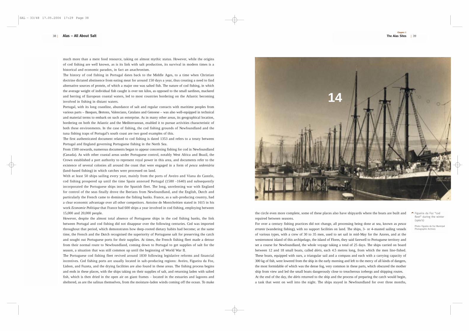
Figueira da Foz “codfleet” during the winter(1960’s)
Photo: Figueira da Foz MunicipalPhotographic Archives
much more than a mere food resource, taking on almost mythic status. However, while the origins
of cod fishing are well known, as is its link with salt production, its survival in modern times is a
historical and economic paradox, in fact an anachronism.
The history of cod fishing in Portugal dates back to the Middle Ages, to a time when Christian
doctrine dictated abstinence from eating meat for around 150 days a year, thus creating a need to find
alternative sources of protein, of which a major one was salted fish. The nature of cod fishing, in which
the average weight of individual fish caught is over ten kilos, as opposed to the small sardines, mackerel
and herring of European coastal waters, led to most countries bordering on the Atlantic becoming
involved in fishing in distant waters.
Portugal, with its long coastline, abundance of salt and regular contacts with maritime peoples from
various parts – Basques, Bretons, Valencians, Catalans and Genoese – was also well-equipped in technical
and material terms to embark on such an enterprise. As in many other areas, its geographical location,
bordering on both the Atlantic and the Mediterranean, enabled it to pursue activities characteristic of
both these environments. In the case of fishing, the cod fishing grounds of Newfoundland and the
tuna fishing traps of Portugal’s south coast are two good examples of this.
The first authenticated document related to cod fishing is dated 1353 and refers to a treaty between
Portugal and England governing Portuguese fishing in the North Sea.
From 1500 onwards, numerous documents began to appear concerning fishing for cod in Newfoundland
(Canada). As with other coastal areas under Portuguese control, notably West Africa and Brazil, the
Crown established a port authority to represent royal power in this area, and documents refer to the
existence of several colonies all around the coast that were engaged in a form of pesca sedentária
(land-based fishing) in which catches were processed on land.
With at least 50 ships sailing every year, mainly from the ports of Aveiro and Viana do Castelo,
cod fishing prospered up until the time Spain annexed Portugal (1580 -1640) and subsequently
incorporated the Portuguese ships into the Spanish fleet. The long, unrelenting war with England
for control of the seas finally drove the Iberians from Newfoundland, and the English, Dutch and
particularly the French came to dominate the fishing banks. France, as a salt-producing country, had
a clear economic advantage over all other competitors. Antoine de Montchrétien stated in 1615 in his
work Economie Politique that France had 600 ships a year involved in cod fishing, employing between
15,000 and 20,000 people.
However, despite the almost total absence of Portuguese ships in the cod fishing banks, the link
between Portugal and cod fishing did not disappear over the following centuries. Cod was imported
throughout that period, which demonstrates how deep-rooted dietary habits had become; at the same
time, the French and the Dutch recognised the superiority of Portuguese salt for preserving the catch
and sought out Portuguese ports for their supplies. At times, the French fishing fleet made a detour
from their normal route to Newfoundland, coming down to Portugal to get supplies of salt for the
season, a situation that was still common up until the beginning of World War II.
The Portuguese cod fishing fleet revived around 1830 following legislative reforms and financial
incentives. Cod fishing ports are usually located in salt-producing regions: Aveiro, Figueira da Foz,
Lisbon, and Fuzeta, and the drying facilities are also found in these areas. The fishing process begins
and ends in these places, with the ships taking on their supplies of salt, and returning laden with salted
fish, which is then dried in the open air on giant frames – located in the estuaries and lagoons and
sheltered, as are the salinas themselves, from the moisture-laden winds coming off the ocean. To make
Alas – All About Salt38 |
<
14
Chapter 1
The Alas Sites | 39
SAL – 33/48 17.05.2004 17:29 Page 38

the use of salt as a method of preserving the catch, as being uneconomic when compared to refrigeration.
Fishing began to decline towards the end of the 1970s, but the Portuguese did not abandon their salt
cod. They began buying the fish from the countries of origin and preserving it in Portugal. However,
the new techniques required less salt, which in turn had a negative influence on Portuguese salt
production, which also began to decline sharply from that time onwards.
Most regions of Portugal maintain a high per capita consumption of salt cod: 16 kg/year. In many regions,
boiled with potatoes and cabbage, it is the traditional dish for supper on Christmas Eve, the most impor-
tant family celebration. Every restaurant, from the humblest to the most sophisticated, includes at least one
salt cod dish on its menu. The long association with cod fishing and the fish itself has meant that salt cod
plays a central part in the popular imagination of the Portuguese, and is nowadays an anachronistic
tradition that few other peoples have maintained and none with the same fervour as the Portuguese.
A large seca in Figueirada Foz
Photo: Figueira da Foz Municipal Photographic Archives
only returning to Portugal around the middle of September. Cod fishing was an extremely arduous
occupation under these conditions, and accidents and deaths were by no means uncommon.
In the late 1920s Portugal underwent a political change, with the establishment of an authoritarian
regime that was to last for more than 40 years. The regime, strongly nationalistic in character,
proclaimed itself the Estado Novo (New State), and set out to glorify the accomplishments of the
Portuguese, particularly the epic adventures of the Discoveries, which became a constant element in
the government’s discourse and imagery. Against this background, expanding the cod fishing fleet
was presented as the return of Portugal to the sea, and up to 70 ships came to be involved in this
activity. The annual departure of the fleet from Lisbon was an important event: dozens of ships painted
white – the official colour of the Portuguese cod fishing fleet – and bedecked with multicoloured flags,
received the blessing of the Church and the State and set sail for the icy waters of Newfoundland,
gliding down the river in the bright sunshine of the Lisbon spring like swans.
Despite the depletion of stocks in the Newfoundland fishing banks, which led Portuguese fishermen to seek
out new sources around Greenland, the quotas imposed on catches by the countries with jurisdiction over
the fishing grounds, and technological advances in fishing and preservation processes, Portugal continued
to use traditional methods: sailing vessels, line-fishing and salting. The majority of countries abandoned
Workers in a seca
Photo: Figueira da Foz Municipal Photographic Archives
<<
Chapter 1
The Alas Sites | 41Alas – All About Salt40 |
1516
SAL – 33/48 17.05.2004 17:29 Page 40