ancient landscapes of uruguay - udelar
TRANSCRIPT

1
CAPÍTULO EN CORRECCIONES FINALES:
Panario D, Gutiérrez O, Sánchez Bettucci L, Peel E, Oyhantçabal P, Rabassa J
(2013) Ancient landscapes of Uruguay. In: Jorge Rabassa, Clifford Ollier
(Eds), Gondwana Landscapes of Southern South America.
Serie: Springer Earth System Sciences. (In press)
ANCIENT LANDSCAPES OF URUGUAY
Daniel Panario (1)
, Ofelia Gutiérrez (2)
, Leda Sánchez Bettucci (3)
, Elena Peel (4)
, Pedro
Oyhantçabal (5)
, Jorge Rabassa (6)
1/
UNCIEP, Instituto de Ecología y Ciencias Ambientales (IECA), Facultad de Ciencias,
UdelaR, Uruguay, [email protected], [email protected]. 2/
UNCIEP, Instituto de Ecología y Ciencias Ambientales (IECA), Facultad de Ciencias,
UdelaR, Uruguay, [email protected], [email protected]. 3/
Departamento de Geología, Facultad de Ciencias, Montevideo, Uruguay,
Departamento de Geología, Facultad de Ciencias, Montevideo, Uruguay,
Departamento de Geología, Facultad de Ciencias, Montevideo, Uruguay,
CADIC-CONICET, Ushuaia, Argentina, [email protected].
ABSTRACT
In this chapter, based on the available geological information, a model for the genesis
and evolution of the Uruguayan landscape is proposed. A structural framework of the
landscape evolution is provided and the record of such evolution in the most representative
geological units is considered. A brief summary of the Uruguayan geology and its location in
the regional context is performed, from Precambrian to Cenozoic times.
From the analysis of the geological record, it may be observed that the climate was
very arid during part of the Jurassic and the Early Cretaceous. Together with the lava flows of
the Arapey Formation, the climate became less arid as the Gondwana continents were
becoming apart from each other. However, the geological record suggests that semiarid
climates were still prevailing. In the Middle Cretaceous, semiarid and wetter climates
progressively alternated, until the Early Tertiary, when very wet and warm conditions were
established, in coincidence with the “Paleocene Eocene Thermal Maximum (PETM)”,
followed by semiarid climates in the Oligocene, wetter conditions in the Miocene and
semiarid again in the Pliocene, with alternating semiarid and humid conditions during the

2
entire Quaternary.
On the basis of the paleoclimatic evolution, the development of relief is discussed,
considering as bases for the analysis the different morphostructural units in which the country
is divided. Due to their size, shape and location (passive margin) of Uruguay, climate
uniformity is assumed for each period throughout the entire territory. It is also assumed that
the surfaces around elevations of 500 meters correspond to relicts of probably pre-Cretaceous
etchplains, strongly denudated, which are observed only in the surroundings of Aiguá.
The landforms situated below the oldest surfaces, for instance those below 320 m a.s.l.
in the Easthern Hills Regions (Sierra del Este), correspond to a new generation of
geomorphological surfaces that may be considered of Cretaceous age, according to the
information presently available. This surface may be correlated with the oldest surface
developed on top of the lava flows of the Arapey Formation.
The extremely warm and wet climate of the Eocene prepared the conditions for the
planation processes that covered most of the Uruguayan territory during the Oligocene,
generating pediplains which were later reworked during the Late Cenozoic, up to the
Quaternary, generating a landscape of smooth hills.
The morphogenetic potential of each morphostructural region determined the available
energy of the resulting landscape, being this at a minimum in the Santa Lucía Basin, which
continued to be under subsidence condition until the Tertiary, and almost non-existant in the
Laguna Merín Basin, where subsidence remains active until the Holocene.
3
1. INTRODUCTION
Uruguay lies on the West Atlantic Ocean coast of South America, between 30° and 35°
South latitude and 53° and 58° West longitude (Figure 1). It has a total land area of 176,215
km2. The Uruguayan relief is quite reduced, between sea level and maximum elevation
around 500 m a.s.l. (Figure 2). Most of the territory is smoothly undulated and it is developed
within a range of 0 to 200 m a.s.l.
The climate of the region is temperate with an annual rainfall of 1200 mm yr-1
and a mean
temperature of 18 °C. It is of the humid subtropical type (Cfa according to the classical
Köppen climate classification). Seasons are properly well separated: spring is frequently
humid, cool, and windy; summers are warm; autumns are mild; and winters are chilly and
uncomfortably damp. Bidegain and Caffera (1997) suggested the following climatic
classification: (1) mild climate, moderate, and rainy (the cooler temperatures standing
between -3 °C and 18 °C); (2) wet climate (rain is irregular, intermediate conditions between
w and Köppen s types): "F Type ", and (3) specific variety of temperature (temperature of the
warmest month above 22 °C): "A Type ".
2. REGIONAL GEOLOGY
2.1 Precambrian geology
Uruguay is part of the South American Platform and its geology consists of a
Precambrian basement cropping out in the southern part, and Paleozoic to Mesozoic
sediments and Mesozoic basaltic flows in the northern region, the latter being part of the
Paraná Basin. Two main Mesozoic rift basins, related to the opening of the South Atlantic
Ocean, are present in the southern (Santa Lucía Basin) and in the eastern portion of the
country (Laguna Merín Basin) (Figures 3, 4 y 5).
The Precambrian basement comprises nearly approximately the 45 % of the country
surface and different approaches have been used within the last 30 years to define its main
units. A first division was postulated by Ferrando and Fernández (1971), who considered two
groups of ages defining two main domains, one of them of Paleoproterozoic age (2.2 – 2.0
Ga) in the southwest, and the other of Neoproterozoic age (900 – 550 Ma) in the East.
Afterwards, Fragoso-Cesar (1980) defined the Dom Feliciano Mobile Belt (Neoproterozoic),

4
within the Río de la Plata Craton (RPC).
The Río de la Plata Craton (RPC) was originally defined by Almeida et al. (1973)
including the older cratonic areas. Later, Bossi and Campal (1992) considered it as built up of
two main terranes, the Piedra Alta Terrane (PAT) on the western side of the Sarandí del Yí
Shear Zone (SYSZ) and the Nico Pérez Terrane (NPT) developed between the Sarandí del Yí
and the Sierra Ballena Shear Zone (SBSZ) (see Figure 5). Recently, Oyhantçabal et al. (2011)
proposed the redefinition of the Río de la Plata Craton including only the younger portion of
the Paleoproterozoic rocks which were not tectonically reworked during the Neoproterozoic.
According to this new definition, the Río de la Plata Craton (RPC) crops out only in the
Piedra Alta Terrane of Uruguay (see Figure 5) and in the Tandilia system in Argentina
(Cingolani 2011). The Nico Pérez Terrane on the other hand, includes Archean and
Paleoproterozoic rocks, was strongly tectonically reworked during the Neoproterozoic and
Brasiliano granitic intrusions are widespread, it should therefore be considered as an
allochthonous basement unit, latter accreted to the Río the la Plata Craton (Oyhantçabal et al.
2011; Rapela et al. 2011).
The Dom Feliciano Belt (DFB) crops out in eastern Uruguay (see Figure 5) and extends
for more than 1,000 km along the Atlantic coast of Uruguay and southern Brazil. It was
developed between ca. 750 and 550 Ma (Sánchez Bettucci et al. 2010a) and represents the
Brasiliano/Pan-African orogenic cycle. It is genetically related to tectonic episodes that
occurred during the convergence of the Río de La Plata, Congo, and Kalahari cratons (Figure
6) during Neoproterozoic times (Sánchez Bettucci et al. 2010a).
The basement of the Dom Feliciano Belt in the southern portion is named as the
Campanero Unit (Sánchez Bettucci 1998; Sánchez Bettucci et al. 2010b) and comprises
mainly orthogneisses with protolith age around 1.7 Ga (U/Pb SHRIMP in zircon; Mallman et
al. 2003). Similar ages were obtained by Sánchez Bettucci et al. (2004). In the easternmost
part of the area, a pre-Brazilian Basement Inlier, the Cerro Olivo Complex (Masquelin 2002;
Masquelin et al. 2012), consists of gneisses, migmatites and granulites of Neoproterozoic age.
The Dom Feliciano Belt on a regional scale is subdivided into three main tectonic units,
from East to West (Basei et al. 2000): (a) Granite Belt, (b) Schist Belt, and (c) Foreland Belt.
The Granite Belt is represented by three large batholiths known as the Aiguá Batholith
(Uruguay), Pelotas Batholith (Rio Grande do Sul State, Brazil) and Florianopolis Batholith
(Santa Catarina State, Brazil). Ages between 630 and 550 Ma have been reported. These

5
batholiths show calc-alkaline affinity.
The Schist Belt comprises pre-collisional Neoproterozoic meta-volcanic and
sedimentary sequences showing metamorphism under greenschist to lower amphibolite facies.
Three lithostratigraphic units are defined in this belt: the Lavalleja Group (Uruguay),
Porongos (Rio Grande do Sul) and Brusque (Santa Catarina) groups of southern Brazil.
The Neoproterozoic Lavalleja Group is composed mainly of basic volcanics, schists,
calc-schists and limestones, conforming three formations (Minas, Fuente del Puma and Zanja
del Tigre; Sánchez Bettucci et al. 2001). Recently, the Zanja del Tigre Formation (Meso- to
Neoproterozoic) integrated by limestones, quartzites, pelites, sandstones and minor BIF’s
(“Banded Iron Formation”) and acid volcanic rocks, metamorphosed in greenschists to lower
amphibolite facies (Sánchez Bettucci and Ramos 1999; Sánchez Bettucci et al. 2001, 2010a),
is considered as a basement inlier of the Dom Feliciano Belt based on isotopic data
(Oyhantçabal et al. 2009; Sánchez Bettucci et al. 2010a).
The Foreland Belt consists of several volcano-sedimentary and sedimentary successions
located between the Schist Belt and the Paleoproterozoic domains of the Río de la Plata
Craton (Basei et al. 2000). These basins include marine to molasse Ediacaran deposits of the
Arroyo del Soldado (Gaucher 2000; Gaucher et al. 2003, 2004) and Maldonado Groups
(Pecoits et al. 2004, 2008; Teixeira et al. 2004). These groups are affected by very low- to
low-grade metamorphism and deformation.
The Sierra de Las Animas – Aiguá area is considered the region of Uruguay where the
relicts of Gondwana age paleosurfaces are best preserved.
2.2 Overview of the Phanerozoic geology of Uruguay
2.2.1. Paleozoic Paraná foreland basin
The Paleozoic Paraná Basin is located at the central southern region of South America.
It is a foreland basin with sedimentary deposition ranging in age from Neo-Ordovician to
Tertiary. This basin occupies about 1.7 million km2 in Argentina, Bolivia, Brazil, Paraguay
and Uruguay. The basin has a NNE-SSW-trending elliptical form with two-thirds of its area
covered by Mesozoic basaltic lavas. The stratigraphic record of this vast basin reaches 7,000
m in thickness in the central depositional centre, just under the Paraná River (Milani and
Zalán 1999). Milani et al. (1998) suggested that the Paraná Basin comprises six stratigraphic

6
mega-sequences delimited by interregional unconformities (Vail et al. 1977). The eastern
border of the Paraná Basin corresponds to a crustal region deeply affected by the South
Atlantic Ocean rifting (see Figure 3). Consequently, the uplift and erosion have been
responsible for the removal of large amounts of Paleozoic sedimentary rocks .The western
border of this basin is defined by the Asunción arch, a flexural bulge related to the loading of
the Cenozoic Andean thrust belt nearby Argentina and Bolivia, whereas the North and the
South borders, these deposits on-lap the Precambrian basement (Milani and Zalán 1999). The
arrangement of this basin has led some authors to postulate foreland basin deposits
(Catuneanu 2004), together with the Karoo (South Africa), Beacon (Antarctic) and Bowen
basins (Australia).
The sedimentary record in Uruguay begins in the Lower Devonian to Lower Permian.
The Devonian units constitute the Durazno Group (Veroslavsky et al. 2006) (Figure 7) and
the Permo-Carboniferous units form the Cerro Largo Group (de Santa Ana and Veroslavsky
2003; de Santa Ana et al. 2006a). The Durazno Group comprises the Cerrezuelo, Cordobés
and La Paloma formations and it represents an almost complete transgressive-regressive (T-
R) cycle of marine and continental sediments. The sedimentary environments evolved from
channelized braided rivers (the Cerrezuelo Formation) to clayey slope (the Cordobés
Formation) and finally, littoral plains (the La Paloma Formation). The start of the
Neopaleozoic sedimentation (de Santa Ana et al. 2006b) is marked by extensive glacial,
glacial-marine or glacial-influenced sedimentary records. The Cerro Largo Group (de Santa
Ana and Veroslavsky 2003; de Santa Ana et al. 2006a) is characterized by glacigenic (Late
Carboniferous – Early Permian), transitional, marine and finally fluvio-eolian (Late Permian)
cycles. The most conspicuous levels are the glacial deposits that comprise diamictites and
tillites. A compressional tectonic regime was recognized in seismic profiles and outcrops, and
it is assigned to Permian-Triassic times (de Santa Ana and Veroslavsky 2003). This tectonic
regime reactivated normal faults. On the other hand, Oleaga (2002) based on geophysical data
suggested that the Precambrian basement is located at a depth of 3,500 m.
2.2.2. Mesozoic
The Atlantic Ocean Uruguayan margin, a portion of the eastern margin of the South
American platform, corresponds to a passive or Atlantic type margin. According to Turner et
al. (1994), the thermal anomaly or Tristan da Cunha plume, was responsible for the opening
of the South Atlantic Ocean and had its peak between 137 and 127 Ma. Thomaz-Filho et al.

7
(2000) suggested that magmatic activity occurred in different stages during the break-up of
South America and Africa (Cesero and Ponte 1997). The most important extensional event in
Uruguay related to the break apart of Pangea, took place in the mid-Triassic and is
represented by Cretaceous magmatism related to continental rifting and is part of the Paraná-
Etendeka magmatic province. The deformation is dominated by brittle faulting that affected
all linked units, and is characterized by normal faults, usually of short length and average
East-West orientation dipping toward both the North and South. Also, there is a series of
N350º faults with westward to sub-vertical inclinations. Some brittle features are evidenced
by gouge formation. The direction of preferential fault is N75º to N120º that generates hemi-
graben type basins filled by clastic deposits and alkaline and peralkaline magmatism.
2.2.2.1. Extensional magmatism
The extensional magmatism was related to the continental rifting (Tristan da Cunha
mantle plume) (e.g. O'Connor and Duncan 1990; Peate et al. 1990; Hawkesworth et al. 1992)
and it is part of the Paraná-Etendeka magmatic province. The Paraná-Etendeka igneous
province is one of the main flood volcanic provinces in the world covering an area of 1.2 x
106
km2, with its magmatic activity peak at ca. 132 Ma (Erlank et al. 1984; Bellieni el al.
1984; Renne et al. 1992, 1996a, 1996b). The South American portion of this province
(Paraná) contains an estimated acidic volcanic rock of 3% of the total volume (Bellieni et al.
1984, 1986), whereas in the African portion (Etendeka) it is estimated in more than 5 % of the
total volume. This difference of proportions would be related to the rift geometry asymmetry
(Turner et al. 1994). The Paraná basalts were defined as aphyric tholeiitic basalts (Comin-
Chiaramonti et al. 1988). Based on the criteria of separation in low TiO2 (≈ 1) and high TiO2
(> 3) proposed by Bellieni et al. (1984), Fodor (1987), Cox (1988), Mantovani et al. (1985),
and Turner and Hawkesworth (1995), amongst others, the existing data in Uruguay fall in the
field of low TiO2 (sensu Sánchez Bettucci 1998).
2.2.2.2. Unimodal extensional magmatism
In Uruguay the unimodal extensional magmatism is named as the Arapey Formation
(Bossi 1966; see Figure 5) and it is outcropping in the NW region of the country. The ages
obtained for this formation are ca. 132 Ma (Creer et al. 1965; Umpierre 1965, in Bossi 1966;
Stewart et al. 1996; Feraud et al. 1999). The ~134 Ma corresponds with main geodynamic

8
changes in the Earth’s history where large igneous provinces (LIP´s) are developed (Renne et
al. 1996a, 1996b). Contemporaneously with these flood basalts, alkaline complexes were
emplaced around the margin of the Paraná basin. The Paraná Province display characteristics
of bimodality with a strong geographic correlation. The volcanic suite includes andesitic
basalts to andesites. The volcanic rocks of Arapey Formation are emplaced above aeolian
sandstones (Tacuarembó Formation, Jurassic-Cretaceous). A latest tectonic event determined
that these basalts were tilted between 3° to 10° to the WSW. A major tectonic lineament
(Sarandí del Yí Shear Zone) controlled not only the emplacement of basalts, but also the
further development of the Littoral Basin.
2.2.2.3. Bimodal extensional magmatism
The bimodal extensional magmatism is represented by the Puerto Gómez and Arequita
formations, and the San Miguel and Valle Chico complexes. These units in SE Uruguay are
linked to aborted rifts (failed arms) associated with the opening of the South Atlantic Ocean.
The Arequita Formation is represented by acidic volcanic rocks including lava flows
and pyroclastic rocks with rhyolitic to dacitic compositions. The high Zr concentrations
indicate that these rocks show peralkaline affinity (Kirstein et al. 1997, 2000). The per-
alkaline rhyolites suggest an important late magmatic episode in the continental rifting event
(Sánchez Bettucci 1998). The Puerto Gómez Formation is constituted by olivine and alkaline
basalts (hawaiite), of strongly amygdaloid aspect, suggesting shallow submarine
environments. Sánchez Bettucci (1998) suggested the occurrence of flows with pillow lavas.
The Valle Chico Complex (Muzio 2000; Lustrino et al. 2005) is composed of felsic
plutonic rocks (quartz-monzonites to syenites, quartz-syenites and granites), volcanic rocks
and dykes (quartz-latites to trachytes and rhyolite). Lustrino et al. (2005) suggested chemical
similarities between the Valle Chico Complex and the Arequita Formation. Lustrino et al.
(2003) suggested that the existence of these mildly alkaline to transitional basic rocks is clear
evidence that the Puerto Gómez and Arequita formations are atypical among the Paraná–
Etendeka Igneous Province.
2.2.2.4. Litoral Oeste intracratonic basin
Intracratonic sag sedimentary basins occur in the middle of stable continental or
cratonic blocks, and are infrequently fault bounded, although strike-slip faulting can occur

9
within them (Middleton 1989). The Litoral Oeste basin of Uruguay occupies an area just over
ca. 50,000 km2 continuing westward in the “Mesopotamia” region of Argentina. The
basement of the basin in the southern portion is the Piedra Alta Terrane (Paleoproterozoic),
whereas in the North and Northeast the basement is the Arapey Formation. The evolution of
this basin apparently was controlled by thermo-tectonic subsidence (Goso and Perea 2004).
This basin is filled by Cretaceous and Cenozoic deposits. The Cretaceous units are the
Guichón and Mercedes formations, both representing fluvial deposits (Goso and Perea 2004).
Moreover, the Cenozoic deposits are represented by the Fray Bentos, Salto and Raigón
formations. The Fray Bentos Formation (Late Oligocene) comprises aeolian silts and scarce
fluvial deposits developed in dry environments.
2.2.2.5. Rift Deposits (Santa Lucía and Laguna Merín basins)
The Santa Lucía and Laguna Merín basins (see Figure 5) are located in the South and
East of Uruguay, respectively. Both basins present an elongated E-NE shape and are
considered a failed rift formed during the Gondwana breakup (Sprechmann et al. 1981). They
were controlled by the Santa Lucía-Aigua-Merín (SaLAM) tectonic alignment (see Rosello et
al. 1999) related to the Paraná–Etendeka volcanic Province (O’Connor and Duncan 1990). In
the Santa Lucía Rift, the Santa Rosa structural high (parallel to the basin borders) is located in
the central region of the basin and divides it in two sub-basins. The Cretaceous volcanic and
sedimentary in-filling is up to 2,500 m thick, whereas the Cenozoic sediments are only a few
tens of meters thick (de Santa Ana et al. 1994). The early Cretaceous sequence (the Migues
Formation, 1,800 m thick; Jones 1956) represents the deepest levels of the basin and it is
composed of sandstones, siltstones and mudstones. The Migues Formation is overlain by
siltstones and sandstones of the Oligocene Fray Bentos Formation.
The calcium carbonate deposits (the Mercedes Formation, Bossi et al. 1975) found in
the Santa Lucía Basin were considered as part of the Upper Cretaceous (Veroslavsky et al.
1997) and were formerly correlated to the "Calizas del Queguay" deposits that crop out in
western Uruguay. Recent studies considered that these siltstones are the result of calcrete
formation, post-depositional processes that occurred during the Tertiary (Goso and Perea
2004) or Early Pleistocene (Panario and Gutiérrez 1999). Different authors (Lambert 1940;
Jones 1956; Goso 1965; Goso and Bossi 1966a, 1996b; Gómez Rifas et al. 1981; Preciozzi et
al. 1985; de Santa Ana et al. 1994; Peel et al. 1998) assigned a lacustrine origin to these

10
deposits. Also, The Mercedes Formation records the most significant pedogenetic processes
occurred in the Cenozoic times such as ferrification, silicification (silcrete formation) and
calcretization.
The Laguna Merín Basin is filled primarily by volcanic rocks: basalts (the Puerto Gómez
Formation), rhyolites, dacites, ignimbrites (the Arequita Formation), and to a lesser extent
conglomerates and red sandstones (Veroslavsky 1999) and Quaternary loess and sands units.
2.2.3. Cenozoic
Towards the end of the Cretaceous, subsidence processes slowed down as the basins
were filled, and during the Cenozoic deposition and sedimentation were limited by uplift and
erosion. The preserved sedimentary deposits are linked to successive transgressive and
regressive eustatic cycles recorded at regional and global scale during the Cenozoic. Based on
drilling information of the continental shelf, a detailed and fairly continuous record of marine
sediments appears, corresponding to the Cretaceous – Tertiary boundary. Many successive
variations in sea level were recognized during the rest of the Cenozoic (Ubilla et al. 2004).
The base of the Paleogene is poorly represented. The scarcity of Paleogene geological
records is related to non-depositional processes that indicate climate variations at the
beginning of the Paleogene. Examples include, the development of oxysol and ferricrete
formation in the Eocene (Panario and Gutiérrez, 1999) or in the upper Paleocene-Eocene, and,
particularly on Cretaceous continental sediments (already mentioned above), the development
of silcretes, fossiliferous pedogenetic calcretes, limestone and lacustrine deposits.
In the Oligocene, due to a basement reactivation linked to the Andean orogeny,
alluvial and fluvial deposits, landslide processes, and loess materials occurred. During the
Late Miocene, there was a new marine transgression (Martínez 1989; Ubilla et al. 2004) and
in the Pliocene-Pleistocene continental evolution processes occurred, mainly developing
extensive fluvial systems.
The Quaternary is characterized by the development of continental deposits on the
coast of the Río de La Plata and the Atlantic Ocean. Associated with frequent oscillations of
sea level, barrier islands, lake sedimentation, marsh and lagoon deposits occurred (Ubilla et
al. 2004).
The Fray Bentos Formation (Bossi 1966) outcrops in western Uruguay in the Paraná
Basin, and to the South and East in the Santa Lucía and Laguna Merín basins. It lies
unconformably on the Mercedes Formation and on the Precambrian basement. It is covered

11
unconformably by the Camacho (Miocene) and Salto (Pliocene-Pleistocene) formations. The
Fray Bentos Formation consists of fine sandstones, loess siltstones, mudstones,
conglomerates, and diamicton levels. It represents the first significant depositional episode
during the Cenozoic (Goso 1965; Goso and Bossi 1966a; Veroslavsky and Martínez 1996)
only preceded by the removal of oxisols and associated ferricretes and alterites off the main
features as alluvial fans (Panario and Gutiérrez 1999). The thickness in outcrops is less than
15 m, but in the subsurface, it reaches 100 m (Bossi and Navarro 1991).
The Camacho Formation (Figure 8) is composed of a succession of very fine to coarse
sandstones, siltstones and mudstones (Martínez 1994; Ubilla 2004). This unit outcrops along
the coasts of the Colonia and San José departments, but it is also found in subsurface in San
José, Maldonado and Rocha. The maximum outcropping thickness is about 15 m, whereas in
the continental shelf it reaches ca. 200 m (Gaviotín and Lobo drill holes: Stoakes et al. 1991;
Ucha et al. 2004). It lies unconformably over the Precambrian basement, or on the Fray
Bentos Formation (Late Oligocene).
The Raigón Formation (Goso 1965) conformably overlies the Camacho Formation and
it is unconformably deposited over the Fray Bentos Formation and the Precambrian basement
(Spoturno and Oyhantçabal 2004). The Raigón Formation is exposed at the coastal cliffs of
the Río de la Plata with a maximum thickness of 30 m. This pile of sediments is of fluvial and
transitional origin, and it is unconformably covered by the Libertad Formation, which
developed in semiarid continental climatic conditions and has been assigned to the
Pleistocene. This formation has been assigned to the Pliocene (Panario and Gutiérrez 1999)
but, however, some authors like Perea and Martínez (2004) have considered as belonging to
younger land-mammal ages (even Pliocene-Middle Pleistocene) those sediments formed
following the re-transportation process of the Raigón Formation, or otherwise to relate them
with deposits of similar color, grain size characteristics and sedimentary environment of those
corresponding to the genesis of such formation.
Andreis and Mazzoni (1967), following Francis and Mones (1966), named this unit as
the San José Formation, dividing it into two sections: the bottom unit formed by clays, silts,
sandy-silts, and subordinate greenish-gray sands, and the upper portion composed of medium
to very coarse pink to yellow sandstones. According to Bossi and Navarro (1991) the Raigón
Formation consists of green clay, medium fine sand, coarse sands and conglomerate levels.
Besides, Tófalo et al. (2006) indicated that these fluvial sediments can be divided into two
sections predominantly sandy, separated by a regional discontinuity, pointing out to an
episode of sedimentation reactivation.

12
The Salto Formation is attributed to the Late Pliocene and the Pleistocene, having also
a fluvial origin. It is exposed in small outcrops near the Río Uruguay and it was correlated
with the Raigón Formation by Goso (1965) and Panario and Gutiérrez (1999). It also
correlates with the Salto Chico and Ituzaingó formations in Argentina. According to
Veroslavsky and Montaño (2004), it represents deposits of braided rivers distinguishing two
depositional cycles. These deposits present lenticular geometry, are multi-episodic, and have
normal grading (Tófalo and Morrás 2009).
The Salto, Salto Chico and Ituzaingó formations are all clearly related to the Río de la
Plata Basin, formed by the Paraná and Uruguay rivers, whose basins are only differentiated
since their middle portions and whose sediments have continued to be deposited until today,
according to Herbst (2000), which makes it difficult to establish the chronostratigraphic
location of its deposits, which have been assigned both to the Pliocene and to the Pleistocene
by different authors. Thus, the Salto Formation (Goso 1965; Panario and Gutiérrez 1999) and
the Salto Chico Formation (Iriondo 1996) have been considered to be of Late Pliocene-
Pleistocene age, as it is the case of the Ituzaingó Formation (Iriondo 1980).
The Libertad Formation (Early to Middle Pleistocene; Figure 9) was defined by Goso
(1965). This formation has a generalized distribution throughout the territory, but its greatest
expression takes place in southwestern Uruguay. It has a thickness of about 20 m, lying
unconformably over the Raigón Formation, several Cretaceous formations, and both
Paleozoic rocks and the Precambrian Basement. It is also covered unconformably by Middle
and Late Quaternary formations (Spoturno and Oyhantçabal 2004). According to Bossi and
Ferrando (2000) it includes massive friable mudstones with scattered gravel and abundant
calcium carbonate. According to Tófalo et al. (2006) it corresponds to loess deposits
accumulated in semiarid regions of gentle slope undergoing significant pedogenetic
processes.
Zárate (2003) suggested that this loess, mainly represented by a 1–2 m thick mantle,
has similar composition to similar units of the Northern Pampas loess (Entre Ríos and
Corrientes provinces of Argentina). Two main loess units have been identified, named
Libertad I and Libertad II, of Early and Middle Pleistocene age, respectively (Goso 1965).
The Libertad I Formation is composed of poorly calcareous edaphized loess while the
Libertad II Formation shows evidences of water reworking and pedogenetic modifications.
On the other hand, Sánchez Bettucci et al. (2007) presented preliminary
magnetostratigraphyc results of the Camacho, Raigón and Libertad Formations (Neogene).

13
Reverse polarity signal was found in the Camacho Formation, ascribed to the Gilbert
magnetic zone. The sediments of the Raigón Formation have normal polarity interpreted as
belonging to the Gauss magnetic zone. Finally, the Libertad I Formation shows reverse
magnetic polarity, which is referred to the Matuyama magnetic zone. The paleomagnetic pole
obtained by these authors is located at 88.2º S lat., 189.7º W long, Dp 5º
Dm 7.2º N=39. The
Libertad II Formation showed normal polarity, and it has been assigned to the Brunhes
paleomagnetic age, according to Sánchez San Martín (2010).
In Uruguay, neotectonic studies have not been performed, but some evidence of
tectonic activity is known. Brazilian studies suggested that the Neotectonic period (Eocene-
Oligocene) should be related to the episode at which the last major tectonic reorganization
occurred. The Neotectonic period presents a possible correlation between events of the
Andean orogeny (Bezerra et al. 2001, 2003; Bezerra and Vita-Finzi 2000). Hasui (1990)
suggested that the maximum age of the neotectonic period in Brazil should be the Oligocene,
which corresponds to the most recent extensional pulses of the South Atlantic Ocean
extension. However, the depth at which Cenozoic units are located (at the west and east)
suggests a steady continuous dominant subsidence since the Cenozoic mainly in the eastern
part, whereas in the western region uplifting dominated. In this last region displacement
direction and low magnitude reverse faulting have been identified. In addition, the historical
seismic data in Uruguay include low intensity movements that certainly should have left their
mark in the landscape.
3. GEOMORPHOLOGY OF URUGUAY
3.1. Landscape modelling
The evolution of the Uruguayan landscape is the result of a variety of regional climates
throughout its geological history. These climates had a strong influence upon the landscape
modelling and modification of the pre-existing landforms. The sedimentary materials
generated in the different periods and resulting landforms allow the inference of several
paleoenvironmental features. The time-climate reconstruction based solely upon the observed
landforms is only possible when those landforms have been preserved. Even though only at a
relict level, those remnants are a clear expression of the dominant paleoclimate.

14
These features are only possible under intense conditions or of long enough duration so
as to imprint clear features of undoubted genesis which would provide a reliable
interpretation.
Many landforms have certainly been eroded and erased from the surface: the oldest
relict landforms are mainly represented by isolated elevations, generally thoroughly
denudated. These relicts may be interpreted as either positional inselbergs, bornhardts,
whereas others are considered as etchplains, which are the major landscape features.
3.2. Paleoclimates
3.2.1. Paleozoic
Some paleoclimatic evidence may be established for this region since the Devonian. In
this sense, from the Early Devonian to the Early Permian, several transgressive marine events
have been identified. Continental deposits formed by braided rivers are also found, thus
indicating alternating relatively arid conditions and presumably wetter climates. During the
Early Permian fluvio-aeolian deposits occurred as well, which are related to arid and semiarid
conditions (Goso and Perea 2004). The wetter and warmer periods which would have taken
place may be associated to the clayey facies, due to the landscape stability during the marine
transgressive stages. There were also moraines and till deposits of Carboniferous-Permain
age, which indicate the existence of higher relief, probably located further north.
3.2.2. Mesozoic
The cold and wet conditions of the Permian slowly changed to warmer and drier
climates during the Late Permian and the Triassic. The climate conditions during most of the
Jurassic were clearly those of a large desert, as it is shown by the sandstones of the
Tacuarembó Formation, known as the Botucatú Formation in Brazil, mostly composed of
rubified aeolian sands, which were then active dune fields. This formation also presents
lagoonal environment facies of less extreme conditions (Bossi 1966).
The arid conditions were maintained during the Early Cretaceous, as it is proven by
the existence of silicified barkhan dunes and sand sheets (inter-trap sandstones) coming from

15
the north, interbedded with the Paraná volcanic province basalts.
Later on, the climate seemed to have evolved towards more semiarid conditions,
related to the opening of the South Atlantic Ocean, exposed also by rubified fluvial
sandstones (the Guichón and Migues formations). The semiarid conditions allowed the
discontinuous development of incipient soils (Goso and Perea 2004) which persist until the
end of the Cretaceous, but presumably under a temperate climate according to the
sedimentological data pertaining to the Mercedes Formation. These circumstances suggest
that the conditions needed for the genesis of planation surfaces were relatively continuous
from some time in the Jurassic to the end of the Cretaceous if previous humid condition
prevailed.
3.2.3. Cenozoic
The dominant climatic conditions during the Paleocene are still somewhat unclear,
since the geological record has not enough continuity. Deep drilling data coming from the
submarine shelf will be undoubtedly very useful in this interpretation. The origin and
development of the most extensive geomorphological features of Uruguay may be tracked
back to Eocene (Panario and Gutiérrez 1999) or Late Paleocene times. A widespread
Cenozoic planation of the Uruguayan landscape was possible under the warm and humid
Eocene climate, with deep weathering accompanied by oxysol development and ferricrete
formation. Eocene ferricretes have developed over Cretaceous and Precambrian rocks in
Uruguay, and on basaltic rocks in the provinces of Corrientes and Misiones in Argentina.
Ferricretes appear also as isolated boulders in Jurassic sandstones (the Tacuarembó
Formation; Caorsi and Goñi 1958)
Oligocene erosion of the Eocene soils under generally arid and semiarid conditions
resulted in the deposition of alluvial fans of plintite cobbles (Ford 1988), which pass upwards
through a decimetre transition zone into the loess-dominated Fray Bentos Formation. These
erosion processes were facilitated by the intense Eocene weathering yielding extensive
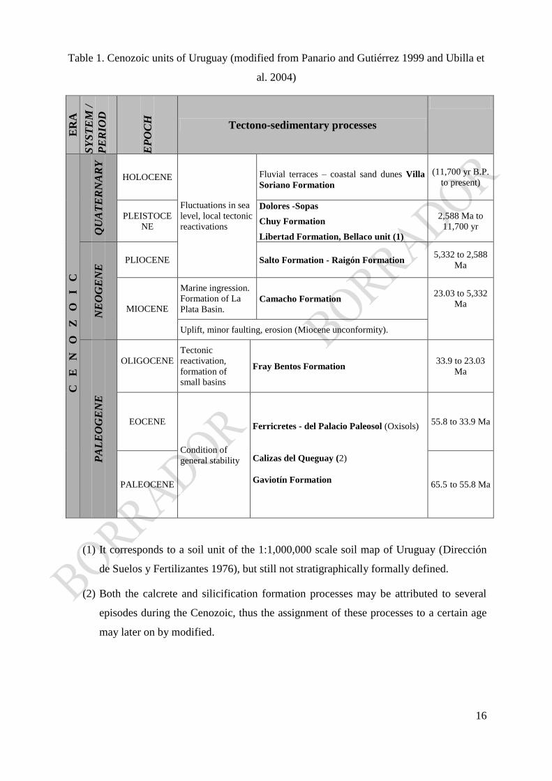
planation surfaces in metamorphic, igneous and sedimentary domains (Table I).
During the Miocene, the geological record (Camacho Formation) indicates a marine
transgression, whose mollusc fauna and the presumed associated continental fauna would
indicate warm and wet climate conditions.
16
Table 1. Cenozoic units of Uruguay (modified from Panario and Gutiérrez 1999 and Ubilla et
al. 2004) E
RA
SY
ST
EM
/
PE
RIO
D
EP
OC
H
Tectono-sedimentary processes
C
E
N
O
Z
O
I
C
QU
AT
ER
NA
RY
HOLOCENE
Fluctuations in sea
level, local tectonic
reactivations
Fluvial terraces – coastal sand dunes Villa
Soriano Formation
(11,700 yr B.P.
to present)
PLEISTOCE
NE
Dolores -Sopas
Chuy Formation
Libertad Formation, Bellaco unit (1)
2,588 Ma to
11,700 yr
NE
OG
EN
E PLIOCENE Salto Formation - Raigón Formation
5,332 to 2,588
Ma
MIOCENE
Marine ingression.
Formation of La
Plata Basin. Camacho Formation
23.03 to 5,332
Ma
Uplift, minor faulting, erosion (Miocene unconformity).
PA
LE
OG
EN
E
OLIGOCENE
Tectonic
reactivation,
formation of
small basins
Fray Bentos Formation 33.9 to 23.03
Ma
EOCENE
Condition of
general stability
Ferricretes - del Palacio Paleosol (Oxisols)
Calizas del Queguay (2)
Gaviotín Formation
55.8 to 33.9 Ma
PALEOCENE 65.5 to 55.8 Ma
(1) It corresponds to a soil unit of the 1:1,000,000 scale soil map of Uruguay (Dirección
de Suelos y Fertilizantes 1976), but still not stratigraphically formally defined.
(2) Both the calcrete and silicification formation processes may be attributed to several
episodes during the Cenozoic, thus the assignment of these processes to a certain age
may later on by modified.

17
Based on paleontological data, this unit was considered by Rodrigues et al. (2008) as
deposited in subtropical marine provinces, ranging from intertidal to middle−shelf setting.
The Pliocene erosion, again under generally arid conditions, resulted in the formation
of coarse braided river deposits known as the Raigón Formation (Goso 1965), alluvial fans
(Malvín Formation; Antón and Prost 1974) and probably the Salto Formation related with the
Uruguay River as well as other fluvial sediments in southwestern Uruguay, comparable to the
Ituzaingó Formation as defined by De Alba (1953), Herbst (1971) and Herbst et al. (1976) in
Argentina (see Krohling and Iriondo 1998; Brea and Zuco 2011).
3.3. The structural framework
The landscape evolution in Uruguay presents different characteristics basically due to
the structural framework and mainly because of the size of its territory, which suggests that
climatic conditions were relatively uniform for the entire surface of the country for each
studied period. The main morphostructural regions are characterized by tectonic events and
within each region, for the variety of rock types involved, which provide the landscape with
their peculiar characteristics (Panario 1988).
The following eight main structural features present in almost the entire extent of the
country clearly transitional zones, of 17 to 20 km in width, with the exception of the western
margin of the Eastern Hills Regions (Sierras del Este) and the Río Uruguay (the boundary
with Argentina), which does not allow the boundary definition at the cartographic resolution
of this scale. In the present graphical representation, the boundaries were determined by
changes in the spectral response of the Landsat images at the chosen scale.
3.4. Landscape characteristics of the different morphostructural regions
3.4.1. North eastern Sedimentary Basin
The Gondwanic Sedimentary Basin was stable in terms of sediment accumulation
since times long before those that modelled the landscape, which allowed the process
expression according to the resistance of the pre-existing materials. The absence of later
accumulation processes of certain relevance suggests that the morphogenetic potential of the
region has not been modified during the Quaternary, when the main incision of the landscape
18
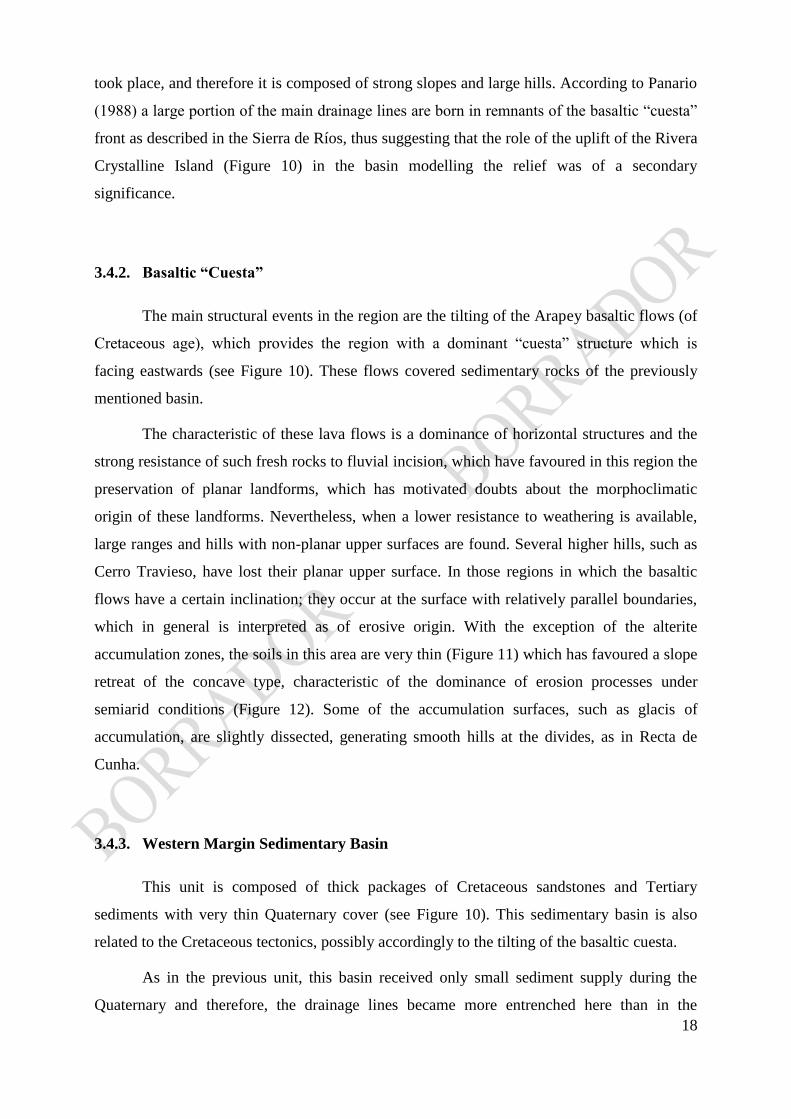
took place, and therefore it is composed of strong slopes and large hills. According to Panario
(1988) a large portion of the main drainage lines are born in remnants of the basaltic “cuesta”
front as described in the Sierra de Ríos, thus suggesting that the role of the uplift of the Rivera
Crystalline Island (Figure 10) in the basin modelling the relief was of a secondary
significance.
3.4.2. Basaltic “Cuesta”
The main structural events in the region are the tilting of the Arapey basaltic flows (of
Cretaceous age), which provides the region with a dominant “cuesta” structure which is
facing eastwards (see Figure 10). These flows covered sedimentary rocks of the previously
mentioned basin.
The characteristic of these lava flows is a dominance of horizontal structures and the
strong resistance of such fresh rocks to fluvial incision, which have favoured in this region the
preservation of planar landforms, which has motivated doubts about the morphoclimatic
origin of these landforms. Nevertheless, when a lower resistance to weathering is available,
large ranges and hills with non-planar upper surfaces are found. Several higher hills, such as
Cerro Travieso, have lost their planar upper surface. In those regions in which the basaltic
flows have a certain inclination; they occur at the surface with relatively parallel boundaries,
which in general is interpreted as of erosive origin. With the exception of the alterite
accumulation zones, the soils in this area are very thin (Figure 11) which has favoured a slope
retreat of the concave type, characteristic of the dominance of erosion processes under
semiarid conditions (Figure 12). Some of the accumulation surfaces, such as glacis of
accumulation, are slightly dissected, generating smooth hills at the divides, as in Recta de
Cunha.
3.4.3. Western Margin Sedimentary Basin
This unit is composed of thick packages of Cretaceous sandstones and Tertiary
sediments with very thin Quaternary cover (see Figure 10). This sedimentary basin is also
related to the Cretaceous tectonics, possibly accordingly to the tilting of the basaltic cuesta.
As in the previous unit, this basin received only small sediment supply during the
Quaternary and therefore, the drainage lines became more entrenched here than in the

19
Southern and South-western Tectonic Basins. The frequent existence of layers of varied
hardness within the accumulated sediments, usually formed by boulder pavements, were the
result of scarp recession during previous epochs, of which very little evidence still remains,
such as Cerro del Clavel, or small elevations of the ferricretes named as the Asencio
Sandstones, or sub-horizontal calcareous duricrusts with rugged borders, when preserving a
surface of sufficient extension and generate hilly interbasin divides, such as those in the
Camino de la Cuchilla, Department of Río Negro. When this surface is smaller, tabular hills
are present, and when the scarp recession allowed the generation of a landscape at a lower
level, smooth hilly valleys occur, generally without much area expression, as those existing in
the Department of Río Negro (Mellizos), the Sánchez Grande and Sánchez Chico River basin,
and Quebracho, at the Department of Paysandú.
3.4.4. South western Sedimentary Basin
Towards the southwest, another sedimentary basin of smaller significance is found
(see Figure 10), based on its territorial extent as well as for the thickness of its sedimentary
accumulations, mainly very thick Tertiary and Quaternary deposits.
This region has acted as a sediment reception basin until recent times, late Middle
Quaternary. The present dissection of the landscape does not agree with its morphogenetic
potential or with the fragility of the composing materials, what suggests that it could have
been affected by tectonic uplift until very recent times. This hypothesis is supported by the
existence of paleo-coastlines and coastal lagoons that are clearly in-filled by sediments even
at elevations above present sea level, the occurrence of marine units such as the Camacho
Fm., several meters above their corresponding stratigraphic units in Argentina (the Paraná
Formation) and, at different levels in Uruguay (Antón and Goso 1974), creeks still have
entrenching capabilities in unconsolidated materials, and Quaternary marine deposits occur at
higher levels than those found in the rest of the country. This uplifting process is perhaps
continued irregularly eastwards, at least along a narrow coastal fringe until the Merín Rift.
3.4.5. Santa Lucía Rift
Southwards, the basin of Santa Lucía is located (see Figure 10), more likely one of the
two most important of the Cretaceous basins within the continental portion of the country,

20
from the point of view of the Cretaceous, Tertiary and Quaternary sediments included in it.
Subsidence and sedimentation were very active in the Santa Lucía Tectonic Basin until the
early Quaternary. This means it had no morphogenetic potential in this period and that after it,
such potential was very reduced, which determined a landscape composed mainly by smooth
hills of gentle slopes, with the exception of those found at the margins of the basin and the
height of Santa Rosa (Rosello et al. 2000).
3.4.6. Laguna Merín Rift
Eastwards, another rift with similar age for the beginning of the event and size is
located (see Figure 10), this basin, however, presents Tertiary and Cretaceous sediments in its
continental side as the oldest materials. Eastern Ranges and the Laguna Merín Tectonic Basin,
a system of hills and low ranges is located, which are composed of crystalline rocks with a
thin Quaternary cover, whose genesis could be related to the tectonic events that formed the
cited basin. Studies on the Uruguayan continental shelf in the region have shown, that this rift
has materials whose age also dates back to Cretaceous (Rosello et al. 2000) their
geomorphological characteristics, which has allowed the interpretation that it has been active
until present times with organic sediments in its most depressed areas. The capture of part of
the Cebollatí River Basin during the Holocene (Bracco et al. 2012) is a clear demonstration of
their recent activity, compared with the Santa Lucía rift, as well as other smaller basins
located in between, such as those of Valle Fuente, Valle Aiguá, that were remodelled during
the Pleistocene.
The nature of the sediments, their diagenetic evolution, and the resistance of the
crystalline and consolidated materials to weathering and the morphogenetic potential of each
of these regions are the conditions that are responsible for their geomorphological profile.
The landscape of this region is practically flat due to its almost null morphogenetic
potential. The deposition of the Pleistocene and Holocene sediments in it is largely developed
under the shape of stepped sedimentary terraces, which allows the identification of at least
four levels of plains separated by breaks in slope, which vary from a few centimetres to a few
metres.

21
3.4.7. South Central Region (Precambrian Brazilian Shield)
The Southern Central Region is occupied by rocks belonging to the Brazilian Shield
(see Figure 10) which have kept under conditions relatively stable at least during Cretaceous
times. These relatively stable conditions, as well as the characteristics of the morphoclimatic
systems dominating the area since those times, have provided the landscape with a “senile”
aspect, which determined that Chebataroff (1955) described it as a “crystalline peneplain”, in
accordance with the genetic interpretations of those times. At present may be defined as
dissected and reworking plains.
The arid and semi-arid periods that occurred with short interruptions during most of
the Tertiary and the Quaternary must have modelled the paleolandscape into erosional plains
with a few local smooth elevations, characteristic of planation on crystalline rocks. During the
early Quaternary, this area received a sedimentary cover of alterites coming from the hilly
areas, these materials being still preserved on the main interfluvial divides. After the
formation of this pediment, it was strongly dissected, a process favoured by deep weathering
processes generated during the Eocene (Panario and Gutiérrez 1999) and earlier. This
dissection produced an undulating relief, interrupted by smooth hills at the interfluvial divides
at the areas with thicker Quaternary accumulation.
3.4.8. Eastern Hills Region
This region is composed by a complex of folded emerged structures and other uplifted
features as Dom Feliciano Belt, of which the oldest one is undoubtedly the Carapé Massif
which corresponds to the main water divide in the region (see Figure 10), due to the fact that
the drainage lines which have their sources in the region are cross-cutting other features,
including highly deformed granites and quartzites as the Sierra de la Ballena and Sierra de las
Cañas chains.
This unit represents the landscape with higher potential energy. Notwithstanding, the
uppermost portion of the Sierras show rather flat top surfaces, which correspond to very old
planation (etchplains) processes developed probably during the Cretaceous or even older, with
others at lower elevation which may have been formed during the Middle Tertiary. This group
of elevations show a clear SW-NE orientation and they would have acted as a mountainous
region of the southernmost Brazilian Shield from which the glacis were carved, providing

22
most of the in-filling sedimentary materials of the Santa Lucía and Laguna Merín rift.
Within this area, certain areas of tectonic down-warping are found which generated
smooth hilly valleys, such as Valle Fuentes and Valle Aiguá.
3.5. Paleosurfaces
3.5.1. Gondwana Paleosurfaces
The uppermost paleosurface on the Granite Batholiths (see “Precambrian Geology”) is
located on granite exposures with two “treppen” in the sense of Penck (1953). The second
surface is located on deeply weathered granite. These surfaces could be of the same age or,
alternatively, of quite close ages, with little time difference in between their formation.
There are obvious dating problems concerning the paleosurfaces, and the correlation
with Southern Brazil has not been established yet.
The existence of a volcanic explosion in this region with an 40
Ar/39
Ar age of ~130 a
128 Ma (Cernuschi and Rodilosso 2011), the lack of evidence of it on the ancient surfaces,
suggest that these surfaces are planation surfaces, probably etchplains, which suffered later on
intensive denudation, presumably since the Oligocene until part of the Pleistocene but for this,
it is necessary to assume a denudation rate of 5 m to10 m per million years, only possible
under extremely stable condition.
The first paleosurface is located approximately between 320-500 m a.s.l., whereas the
second paleosurface is found between 280-320 m a.s.l.
The elevation difference between them is very small, but this would not be too rare in
a tectonically very stable, as it happens in the Tandilia and Ventania ranges of the Buenos
Aires Province, Argentina (Demoulin et al. 2005; Rabassa et al. 1999, 2005, 2010).
The Cerro Campanero, in the Department of Lavalleja, shows a perfect example of
weathering front remnants, on which corestones have been left after removal of the weathered
materials. Some of these corestones are part of dismantled tors (Figure 13), and some of them
may have also reached the state of rocking stones during their evolution. Looking northwest
in Figure 14, the clear flatness of the supposed Gondwana paleosurface is exposed forming
the horizon, with very little local relief, as mentioned before.
In the northern part of the country the inselbergs modelled on basalts of the Arapey
23
Formation prove that they were developed after the eruption of these rocks (Early
Cretaceous). At a lower altitude compared with these relict features, but in accordance with
them, degraded surfaces assigned to arid climates have been described and named as
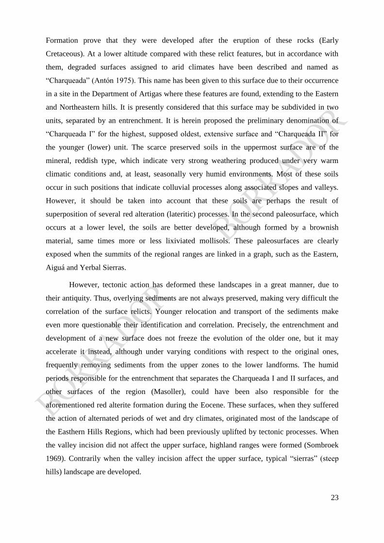
“Charqueada” (Antón 1975). This name has been given to this surface due to their occurrence
in a site in the Department of Artigas where these features are found, extending to the Eastern
and Northeastern hills. It is presently considered that this surface may be subdivided in two
units, separated by an entrenchment. It is herein proposed the preliminary denomination of
“Charqueada I” for the highest, supposed oldest, extensive surface and “Charqueada II” for
the younger (lower) unit. The scarce preserved soils in the uppermost surface are of the
mineral, reddish type, which indicate very strong weathering produced under very warm
climatic conditions and, at least, seasonally very humid environments. Most of these soils
occur in such positions that indicate colluvial processes along associated slopes and valleys.
However, it should be taken into account that these soils are perhaps the result of
superposition of several red alteration (lateritic) processes. In the second paleosurface, which
occurs at a lower level, the soils are better developed, although formed by a brownish
material, same times more or less lixiviated mollisols. These paleosurfaces are clearly
exposed when the summits of the regional ranges are linked in a graph, such as the Eastern,
Aiguá and Yerbal Sierras.
However, tectonic action has deformed these landscapes in a great manner, due to
their antiquity. Thus, overlying sediments are not always preserved, making very difficult the
correlation of the surface relicts. Younger relocation and transport of the sediments make
even more questionable their identification and correlation. Precisely, the entrenchment and
development of a new surface does not freeze the evolution of the older one, but it may
accelerate it instead, although under varying conditions with respect to the original ones,
frequently removing sediments from the upper zones to the lower landforms. The humid
periods responsible for the entrenchment that separates the Charqueada I and II surfaces, and
other surfaces of the region (Masoller), could have been also responsible for the
aforementioned red alterite formation during the Eocene. These surfaces, when they suffered
the action of alternated periods of wet and dry climates, originated most of the landscape of
the Easthern Hills Regions, which had been previously uplifted by tectonic processes. When
the valley incision did not affect the upper surface, highland ranges were formed (Sombroek
1969). Contrarily when the valley incision affect the upper surface, typical “sierras” (steep
hills) landscape are developed.

24
3.5.2. Cenozoic Paleosurfaces
Separated from the old surfaces by an entrenchment, perhaps favoured by the Eocene
alteration process another surface of similar genesis (arid morphogenesis) occurs, which was
named as the Masoller Surface by Antón (1975). Erosion and accumulation glacis that formed
it are found in many localities, as it may be observed in the geomorphological map by Antón
(1975). According to Panario and Gutiérrez (1999) this surface may be assigned to a more
intense planation process that developed during periods of semiarid climate in the Tertiary
(perhaps, the Oligocene), simultaneously with the conglomerates, limestones and aeolian
deposits of the Fray Bentos Formation. This process continued during the Pliocene, when
fluvial deposits also of semiarid conditions were formed, such as conglomerates and
sandstones of the Salto and Raigón formations.
The deposits of the Salto and Ituzaingó formations have been defined as of subtropical
climate by several authors (Iriondo 1980; Jalfin 1988; Herbst 2000). However, it should be
taken into consideration that the Río de la Plata Basin extends over a wide latitudinal band
and it reaches much lower latitudes at its mouth. Therefore, even if the provenance of the
materials may be from tropical or subtropical areas, the conditions in the depositional areas
could have been very different.
The Salto and Raigón formations present a higher variability of their sedimentary
materials which indicates environmental rhythmicity. During their genesis, periods with
sufficient aridity developed so as to transport and deposit coarse materials and other wetter
periods in which the transport and deposition of the finer sediments took place, thus favouring
the formation of large glacis. The deposition of very fine (clayey) materials seems to
correspond to lacustrine environments, characteristics of these climatic conditions when
closed depressions are available (the Raigón Formation). The fact that aeolian silts were
herein incorporated suggests that there were some periods in which, even though locally, a
certain plant cover developed. Towards the later portion of this period and in coincidence
perhaps with the earlier major glaciations, the deposition of the Libertad I Formation took
place, most likely under semiarid conditions. From a genetic point of view, the Libertad
Formation was formed during several Pleistocene glacial periods, without clear internal
unconformities, perhaps with the exception of the events known as Libertad I and Libertad II,
which points towards a loess unit with continuous soil formation, as it has been noted by Blasi
25
et al. (2001) under similar conditions in the Argentine Pampas.
Between the Salto and Raigón formations and the Libertad Formation does not exist
any entrenchment which may indicate the necessary conditions for landscape dissection. The
Libertad I Formation is generally composed of finer materials than the Raigón Formation.
This would imply that a loss of competence of the transportation agents would have taken
place, due to a loss of morphogenetic potential or climatic changes in the region, the latter
interpretation would be preferred. Apparently, the deposition of the upper portion of the
Libertad I Formation would have taken place under somewhat more humid conditions, whose
more evident relicts are the clayey deposits occurring under seasonally confined, shallow
waters where vegetation and/or evaporation would be responsible for their deposition or later
weathering of finer sediments into montmorillonite clays. The smaller amount of illite in
relation with smectites would indicate a warmer climate than during the deposition of the
Libertad sediments.
The deposition of clays and fine materials requires very special conditions which are
related to lakes, ponds or marshes with dense vegetation. The latter case would be the one
better adapted to the conditions in this country, perhaps reconstructing ancient drainage
basins. After the deposition, due to the difficulties to erode the clayey sediments when climate
changed, drainage channels tended to entrench the margins of the swampy areas but not their
deposits. In the long term, a process of relief inversion took place, with the clayey deposits in
the uppermost areas. Considering the crystalline zone, the Risso and La Carolina units of the
1:1,000,000 scale soil map of Uruguay (Dirección de Suelos y Fertilizantes 1976) may be
considered, together since they are zones with vertisols and calcium-montmorillonite
dominated soils. A paleobasin may be reconstructed which, starting at the Eastern Ranges,
would extend south-westwards until approximately the present mouth of the Uruguay River
(Panario and Gutiérrez 1999). The dry period in which the Libertad I Formation deposition
took place would be associated to the glacial periods at the beginning of the Pleistocene, as
low sea levels would be related to glaciation and dry climates. The increase of the
morphogenetic potential implied by lowering sea level is compensated in dry areas by the loss
of erosion potential of the streams, due to loss of yield and detrital load. The entrenchment
under these conditions would have taken place during wetter periods at the end of the
glaciations, before sea level rise. The subsequent climatic alternating periods modelled the
thus formed surfaces, originating most of the present smooth hills like the Cuchilla Grande.
With some relict surfaces found even in the neighbourhood of the city of Montevideo (the La

26
Tabla Range, among others), connected to position inselbergs such as El Cerrito de la
Victoria. The higher energy of the hilly landscape may be attributed to successive periods of
entrenchment affecting the same drainage lines previously established, which forced frequent
changes in slope inclination in the landscape. In those places where the landforms are due to a
varying rock resistance, larger high plains were preserved, such as Cuaró, Recta de Cunha and
Masoller. After the formation of these surfaces, marine transgressions took place, since then,
alternating wetter-drier, warmer-colder climates related to glacial-interglacial periods
represent the dominant conditions during the rest of the Pleistocene and the early Holocene.
4. Final remarks
The existence of pre-Cenozoic paleosurface relicts has been largely discussed from a neo-
Darwinian and classic thermodynamics point of view, still perceived in modern
geomorphology. Although the absolute ages of the older surfaces are difficult to establish at
our present state of the art, some conclusions may be obtained.
(1) For the first time, the nature, characteristics and distribution of Gondwana landscapes
in Uruguay has been presented within the framework of the long-term landscape
evolution of this country.
(2) The different stratigraphic units found in the various morphostructural regions of
Uruguay have been presented and their relationship with the occurrence and
distribution of landscapes and landforms has been discussed and analyzed.
(3) Several features emerged from such analysis. The Cretaceous lava flows of the
northern portion of the country show clear evidence of tilting.
(4) In the topographically higher area, the existence of paleosurface relicts with
recessional scarps of the knick-point type may be observed, carved on the basaltic
flows of the upper section, thus the younger ones.
(5) The topographically lower area of the tilted Cretaceous lava flows is covered by
fluvial deposits pertaining to a Middle Cretaceous sedimentary basin, clearly
genetically separated by the scarp.
(6) Part of the sediments present here is related to the denudation processes that originated
the relicts. Thus, it may be clearly assumed the existence of at least extensive surfaces
of Late Cretaceous age.

27
(7) In those place were the Cretaceous lavas are overlying the northwest margins of the
Dom Feliciano Belt, they are found at elevations around 200 m a.s.l., whereas the
maximum elevations of this structure and its corresponding paleosurface may reach
500 m a.s.l., which could be interpreted as an Early Cretaceous, or even a pre-
Cretaceous age for these surfaces, in which corestones, tors and other landforms
indicating pre-existing deep alteration mantles over highly quartzose, granitic rocks
are found.
(8) The existence of Permian-Carboniferous glacial sediments of the mountain glaciation
type suggests that very high mountain summits were already present in those times.
On the other hand, the occurrence of Eocene ferricrete clasts in the matrix of
Oligocene fine-grained aeolian deposits and the distribution of surfaces framed by iron
mantles at elevations corresponding to the general landscape planation during a
Oligocene semi-arid period, is also according with the extensive planation of the
emerged landscape.
(9) Absolute dating and/or clear correlation among the paleosurfaces of the South
American passive margin with surfaces genetically and geographically related, located
in other parts of South America and Southern Africa, will be undoubtedly needed to
establish a reliable genetic chronosequence.
(10) The study of the provenance of Cretaceous and pre-Cretaceous sediments would
also be a significant input in the future to understand the timing of the development
and denudation of these ancient landscapes.
ACKNOWLEDGEMENTS
The authors are greatly indebted to the Universidad de la República, Montevideo,
Uruguay, and CADIC-CONICET, Ushuaia, Argentina, for the access to various facilities, data
and materials that were used for the preparation of this chapter.
Likewise, they are extremely grateful to the late Professor Tim Partridge (then at the
University of Witwatersrand, Johannesburg, South Africa) and Professor Rodney Maud, for
introducing us in the study, analysis and discussion of Gondwana paleolandscapes. Moreover,
Professor Maud and Dr. Claudio Carignano (CONICET and Universidad de Córdoba,
Argentina) took part of a memorable field trip to the region of Minas, eastern Uruguay, in

28
2000, when some of the ideas exposed in this paper were discussed for the first time. Funding
for such field trip was provided by a National Geographic Society field exploration grant to
Jorge Rabassa, which is deeply acknowledged.
The authors are also thankful to the FAPESP research Project presently developed
under the leadership of Professor Francisco Ladeira (Universidade de Campinas, São Paulo,
Brazil) for allowing the exchange of experience on the Gondwana landscapes of southern
South America for the first time at the regional level.
References
Almeida FFM de, Amaral G, Cordani UG, Kawashita K (1973) The Precambrian evolution of
the South American cratonic margin south of the Amazon River. In: Nairn AEM, Stehli FG
(eds) The Ocean Basin and Margins. The South Atlantic, Plenum Press, New York, vol 1,
pp 411-446
Andreis RR, Mazzoni MM (1967) Sedimentología de las formaciones Kiyú y San José,
Departamento de San José, R. O. del Uruguay. Revista del Museo de La Plata, Sección
Geología 6(41):41-96
Antón D (1975) Evolución Geomorfológica del Norte del Uruguay. Unpublished internal
report, Dirección de Suelos y Fertilizantes, Ministerio de Agricultura y Pesca, Montevideo
Antón D, Goso H (1974) Estado actual de los conocimientos sobre el Cuaternario en el
Uruguay. Dirección de Suelos y Fertilizantes, Ministerio de Agricultura y Pesca,
Montevideo. In: Anais do 25º Congresso Sociedade Brasileira de Geologia, Porto Alegre,
vol 3
Antón D, Prost T (1974) Observaciones sobre las formaciones cuaternarias de la Sierra de las
Ánimas. Unpublished Report presented to the 28th. Brazilian Geological Congress
Basei MAS, Siga Jr O, Masquelin H, Harara OM, Reis Neto JM, Preciozzi Porta F (2000) The
Dom Feliciano Belt and the Rio de la Plata Craton: tectonic evolution and correlation with
similar provinces of southwestern Africa. In: Cordani UG, Milani EJ, Thomaz-Filho A,
Campos DA (eds.) Tectonic Evolution of South America, 31st International Geological
Congress, Rio de Janeiro, pp 311-334
Bellieni G, Comin-Chiaramonti P, Marques LS, Melfi AJ, Nardy AJR, Piccirillo EM,

29
Roisemberg A (1984) High- and low- TiO2 flood basalts from the Paraná plateau (Brazil):
petrology and geochemical aspects bearing on their mantle origin. Neues Jahrb. Mineral.-
Abh. 150:273-306
Bellieni G, Comin-Chiaramonti P, Marques LS, Melfi AJ, Nardy AJR, Papatrechas C,
Piccirillo EM, Roisemberg A, Stolfa D (1986) Petrogenetic aspects of acid and basaltic
lavas from the Paraná plateau (Brazil): geological, mineralogical and petrochemical
aspects. J. Petrol. 27(4):915-944. doi:10.1093/petrology/27.4.915
Bezerra FHR, Amaro VE, Vita-Finzi C, Saadi A (2001) Pliocene-Quaternary fault control of
sedimentation and coastal plain morphology in NE Brazil. J. South Am. Earth Sci. 14:61-
75
Bezerra FHR, Barreto AMF, Suguio K (2003) Holocene sea-level history on the Rio Grande
do Norte State coast, Brazil. Mar. Geol. 196:73-89
Bezerra FHR, Vita-Finzi C (2000) How active is a passive margin? Paleoseismicity in
northeastern Brazil. Geology 28:591-594. doi:10.1130/0091-
7613(2000)28<591:HAIAPM>2.0.CO;2
Bidegain M, Caffera RM (1997) Clima del Uruguay y la región.
http://www.rau.edu.uy/uruguay/geografia/Uy_c-info.htm. Accessed 10 march 2011
Blasi AM, Zárate MA, Kemp RM (2001) Sedimentación y pedogénesis cuaternaria en el
noreste de la pampa bonaerense: la localidad Gorina como caso de estudio. Rev. Asoc.
Argent. Sedimentol. 8(1):77-92
Bossi J (1966) Geología del Uruguay. Departamento de Publicaciones de la Universidad de la
República, Montevideo, vol 2: 469 p
Bossi J, Campal N (1992) Magmatismo y tectónica transcurrente durante el Paleozoico
inferior del Uruguay. In: Gutiérrez J, Saavedra J, Rábano I (eds) Paleozoico Inferior de
Ibero-América, Universidad de Extremadura, Alicante, pp 343-356
Bossi J, Ferrando LA, Fernández A, Elizalde G, Morales H, Ledesma J, Carballo E, Medina
E, Ford I, Montaña J (1975) Carta geológica del Uruguay (1:1.000.000): Dirección de
Suelos y Fertilizantes, Ministerio de Agricultura y Pesca, Montevideo, 25 p
Bossi J, Ferrando LA (2000) Carta Geológica del Uruguay, escala 1/500.000. 2nd ed.
Geoeditores, Montevideo
Bossi J, Navarro R (1991) Geología del Uruguay. Departamento de Publicaciones,

30
Universidad de la República, Montevideo, 970 p
Bracco R, del Puerto L, Inda H, Capdepont I, Panario D, García-Rodríguez F (2012)
Evolución ambiental y constructores de cerritos en la región de India Muerta. Un
replanteo. In: III Jornadas del Cenozoico, Montevideo, 14-15 June 2012, CD-Rom
Brea M., Zuco A.F. 2011. The Paraná-Paraguay basin: geology and paleoenvironments. In:
Albert J.S., Reis R.E. (eds.), Historical Biogeography of Neotropical Freshwater Fishes.
University of California Press, Berkeley, 69-88.
Caorsi J, Goñi J (1958) Geología uruguaya. Boletín del Instituto Geológico del Uruguay
37:1–73
Catuneanu O (2004) Basement control on flexural profiles and the distribution of foreland
facies: the Dwyka Group of the Karoo Basin, South Africa. Geology 32(6):517–520.
doi:10.1130/G20526.1
Cernuschi Rodilosso F (2011) Geology of the Cretaceous Lascano-East intrusive complex:
magmatic evolution and mineralization potential of the Merin Basin, Uruguay.
Unpublished Master of Science Dissertations, Oregon State University, 340 p.
http://hdl.handle.net/1957/20581. Accessed 11 December 2012
Cesero PD, Ponte FC (1997) Análise comparativa da paleogeologia dos litorais atlânticos
brasileiro e africano. Boletim de Geociências da Petrobras, Rio de Janeiro, 11(1/2):1-18
Chebataroff J (1955) Evolución del relieve del Uruguay y de Río Grande del Sur. Revista
Uruguaya de Geografía, 39-96. http://www.periodicas.edu.uy/Revista_
Uruguaya_Geografia/pdfs/Revista_Uruguaya_Geografia_08_1955.pdf. Accessed 4
December 2012
Cingolani CA (2011) The Tandilia system of Argentina as a southern extension of the Río de
la Plata Craton: an overview. Int. J. Earth Sci. 100:221-242
Comin-Chiaramonti P, Belliene G, Piccirillo EM, Melfi AJ (1988) Classification and
petrography of continental stratoid volcanics and related intrusives from the Paraná basin
(Brasil). In: Piccirillo EM, Melfi AJ (eds.) The Mesozoic flood volcanism of the Paraná
Basin: petrogenetic and geophysical aspects. Instituto Astronômico e Geofísico USP, São
Paulo, pp 47-72
CONEAT (1979). Grupos de Suelos. Índices de Productividad. Comisión Nacional de Estudio
Agroeconómico de la Tierra (CONEAT), Ministerio de Agricultura y Pesca, Montevideo,
31
167 p
Cox KG (1988) The Karoo province. In: MacDougall JD (ed) Continental flood basalts,
Kluwer Academic Publishers, Dordrecht, pp 239–271
Creer KM, Miller JA, Gilbert-Smith A (1965) Radiometric age of the Serra Geral Formation.
Nature 207:282-283.doi:10.1038/207282a0
De Alba E (1953) Geología del Alto Paraná en relación con los trabajos de derrocamiento
entre Ituzaingó y Posadas. Revista de la Asociación Geológica Argentina 8:121-161
de Santa Ana H, Goso C, Daners G (2006a) Cuenca Norte: estratigrafía del Carbonífero-
Pérmico. In: Veroslavsky G, Ubilla M, Martínez S (eds) Cuencas Sedimentarias de
Uruguay: Geología, paleontología y recursos naturales - Paleozoico, DIRAC, Facultad de
Ciencias, Universidad de la República, Montevideo, pp 147-208
de Santa Ana H, Goso C, Muzio R, Oyhantçabal P, Veroslavsky G (1994) Bacia do Santa
Lucia (Uruguai): Evolução tectônica e sedimentar. Geociências 13(1):37-52.
de Santa Ana H, Veroslavsky G (2003) La tectosecuencia volcanosedimentaria de la Cuenca
Norte de Uruguay. Edad Jurásico-Cretácico Temprano. In: Veroslavsky G, Ubilla M,
Martínez S
– ,
Montevideo, pp 51-74
de Santa Ana H, Veroslavsky G, Fulfaro V, Rossello E (2006b) Cuenca Norte: Evolución
tectónica y sedimentaria del Carbonífero-Pérmico. In: Veroslavsky G, Ubilla M, Martínez
S (eds) Cuencas Sedimentarias de Uruguay: Geología, Paleontología y Recursos Naturales
- Paleozoico, DIRAC, Facultad de Ciencia , Montevideo, pp
209-256
Demoulin A, Zárate M, Rabassa J (2005) Long-term landscape development: a perspective
from the southern Buenos Aires ranges of east central Argentina. J. South Am. Earth Sci.
19:193-204
Dirección de Suelos y Fertilizantes (1976) Carta de Reconocimiento de Suelos del Uruguay a
escala 1:1.000.000, y Leyenda que la acompaña. Ministerio de Agricultura y Pesca,
Montevideo
Erlank AJ, Marsh JS, Duncan AR, Miller R McG, Hawkesworth CJ, Betton PJ, Rex DC
(1984) Geochemistry and petrogenesis of the Etendeka volcanic rocks from

32
SWA/Namibia. In: Erlank AJ (ed) Petrogenesis of the Volcanic Rocks of the Karoo
Province. Geological Society of South Africa, Special Publication, vol 13: pp 195-245
Féraud G, Bertrand H, Martínez M, Ures C, Schipilov A, Bossi J (1999) 40Ar/39Ar age and
geochemistry of the southern extension of Paraná traps in Uruguay. In: Actas II Simposio
Sudamericano de Geología Isotópica, Córdoba, pp 57-59
Ferrando L, Fernández A (1971) Esquema tectónico cronoestratigráfico del Pre-Devoniano en
el Uruguay. In: Anais do XXV Congresso Brasileiro de Geología, Sao Paulo, vol 1: pp
199-210
Fodor RV (1987) Low- and high-TiO2 flood basalts of southern Brazil: origin from picritic
parentage and a common mantle source. Earth Planet. Sci. Lett. 84(4):423-
430.doi:org/10.1016/0012-821X(87)90007-0
Ford I (1988) Conglomerados con nidos de insectos fósiles: Formación Palmitas (prov.);
Terciario inferior (tentativo). In: Memorias del 6º Panel de Geología del Litoral,
Montevideo, pp 47-49
Fragoso-Cesar ARS (1980) O cráton do Rio de La Plata eo Cinturão Dom Feliciano no
Escudo Uruguaio-Sul-Riograndense. In: Anais do XXXI Congresso Brasileiro de
Geologia, Camboriú, vol 5: pp 2879-2892
Francis JC, Mones A (1966) Artigasia magna n. g., n. sp. (Eumegamyinae) un roedor
gigantesco de la época Pliocena Superior de las barrancas de San Gregorio, Departamento
de San José, República Oriental del Uruguay. Kraglieviana 1(3):89-100
Gaucher C (2000) Sedimentology, palaeontology and stratigraphy of the Arroyo del Soldado
Group (Vendian to Cambrian, Uruguay). Beringeria 26:1-20
Gaucher C, Boggiani PC, Sprechmann P, Sial AN, Fairchild TR (2003) Integrated correlation
of the Vendian to Cambrian Arroyo del Soldado and Corumbá Groups (Uruguay and
Brazil): palaeogeographic, palaeoclimatic and palaeobiologic implications. Precambrian
Res. 120:241-278. doi:10.1016/S0301-9268(02)00140-7
Gaucher C, Chiglino L, Peçoits E (2004) Southernmost exposures of the Arroyo del Soldado
Group (Vendian to Cambrian, Uruguay): palaeogeographic implications for the
amalgamation of W-Gondwana. Gondwana Res. 7:701–714. doi:10.1016/S1342-
937X(05)71057-1
Gomez Rifas C, Heinzen W, Roth W, Spoturno J (1981) Las calizas del Uruguay. Boletín

33
Instituto Geológico del Uruguay 38:5-37
Goso C, Perea D (2004) El Cretácico post-basáltico de la Cuenca Litoral del Río Uruguay:
Geología y Paleontología. In: Veroslavsky G, Ubilla M, Martínez S (eds) Cuencas
sedimentarias de Uruguay: Geología, paleontología y recursos naturales -Mesozoico, 2da
ed, DIRAC, Facultad de Ciencias, Universidad de la República, Montevideo, pp 143-169
Goso H (1965) El Cenozoico en el Uruguay. Instituto Geológico del Uruguay, M.I.E. Ed.
Mimeogr. Montevideo. 36 p
Goso H, Bossi J (1966a) Cenozoic stratigraphy of the Rio Grande do Sul coastal province.
Boletim Paranaense de Geociências 33:54-55
Goso H, Bossi J (1966b) Relevamiento geológico del Departamento de San José. Instituto
Geológico del Uruguay. Unpublished Technical Report, 40 p
Hasui Y (1990) Neotectônica e Aspectos Fundamentais da Tectônica Ressurgente no Brasil.
In: Workshop sobre Neotectônica e Sedimentação Cenozóica Continental no Sudeste
Brasileiro, Sociedade Brasileira de Geologia-Núcleo Minas Gerais, Belo Horizonte, vol 1:
1-31
Hawkesworth CJ, Gallagher K, Kelley S, Mantovani M, Peate DW, Regelous M, Rogers NW
(1992) Paraná magmatism and the opening of the South Atlantic. In: Storey BC, Alabaster
T, Pankhurst RJ (eds) Magmatism and the causes of continental break-up, Geological
Society, London, Special Publication 68, pp 221-240. doi:10.1144/GSL.SP.1992.068.01.14
Herbst R (1971) Esquema estratigráfico de la provincia de Corrientes, República Argentina.
Revista de la Asociación Geológica Argentina 26(2):221-243
Herbst R (2000) La Formación Ituzaingó (Plioceno). Estratigrafía y distribución. In:
Aceñolaza FG, Herbst R (eds) El Neógeno de Argentina, Instituto Superior de Correlación
Geológica INSUGEO, San Miguel de Tucumán, vol 14: pp 181-190
Herbst R, Santa Cruz JN, Zabert LL (1976) Avances en el conocimiento de la estratigrafía de
la Mesopotamia argentina, con especial referencia a la Provincia de Corrientes. Revista de
la Asociación de Ciencias Naturales del Litoral 7:101-121
Iriondo MH (1980) El Cuaternario de Entre Ríos. Revista de la Asociación de Ciencias
Naturales del Litoral 11:125-141
Iriondo MH (1996) Estratigrafía del Cuaternario de la Cuenca del Río Uruguay. Actas XIII
Congreso Geológico Argentino y III Congreso de Exploración de Hidrocarburos, Buenos

34
Aires, vol IV: pp 15-25
Jalfin GA (1988) Formación Ituzaingó (Plio-Pleistoceno) en Empedrado, provincia de
Corrientes: un paleorío arenoso entrelazado tipo Platte. In: Actas de la II Reunión
Argentina de Sedimentología, Buenos Aires, 130-134
Jones GH (1956) Memoria explicativa y mapa geológico de la región oriental del
Departamento de Canelones. Boletín del Instituto Geológico del Uruguay 34:1-193
Kirstein L, Peate DW, Hawkesworth CJ, Turner SP, Harris C, Mantovani MSM (2000) Early
Cretaceous basaltic and rhyolitic magmatism in southern Uruguay associated with the
opening of the South Atlantic. J. Petrol. 41(9):1413-1438
Kirstein LA, Hawkesworth CJ, Turner SP (1997) CFB magmatism in southern Uruguay:
marginal to a mantle plume? In: J.Conf. Abs. Continental Magmatism, VSG - Minsoc '97,
Cambridge, 2(1):44
Krohling D, Iriondo M (1998) Guía de Campo Nº 1: Pampa Norte, Cuenca del Carcarañá.
International Joint Field Meeting Loess in Argentina: Temperate and Tropical. Paraná,
Entre Ríos, Argentina, 36 p
Lambert R (1940) Memoria explicativa de un mapa geológico de reconocimiento del Depto.
de Paysandú y los alrededores de Salto. Instituto Geológico del Uruguay, Montevideo, vol
27: 1-41
Lustrino M, Gomes CB, Melluso L, Morbidelli L, Muzio R, Ruberti E, Tassinari CCG (2003)
Early Cretaceous magmatic activity in southeast Uruguay: trace element and Sr-Nd
isotopic constraints. Proceeding of IV South American Symposium on Isotopic Geology,
Salvador, vol 2: 596-597
Lustrino M, Melluso L, Brotzu P, Gomes GB, Morbidelli L, Muzio R, Ruberti E, Tassinari
CCG (2005) Petrogenesis of the early Cretaceous Valle Chico igneous complex (SE
Uruguay): relationships with Paraná-Etendeka magmatism. Lithos 82(3-4):407-434.
doi:org/10.1016/j.lithos.2004.07.004
Mallmann G, Chemale Jr F, Armstrong RA, Kawashita K (2003) Sm-Nd and U-Pb SHRIMP
zircon studies of the Nico Pérez Terrane, reworked Rio de la Plata Craton, Uruguay. In: IV
South American Symposium on Isotope Geology, Short Papers, Salvador, vol 1: pp 207-
209
Mantovani MSM, Marques LS, De Sousa MA, Civetta L, Atalla L, Innocenti F (1985) Trace

35
element and strontium isotope constraints on the origin and evolution of Paraná continental
flood basalts of Santa Catarina state (southern Brazil). J. Petrol. 26(1):187-
209.doi:10.1093/petrology/26.1.187
Martínez S (1989) Los depósitos de la "transgresión entrerriana" (Mioceno de Argentina,
Brasil y Uruguay). Comparación de sus principales áreas fosilíferas a través de los bivalvos
y los gastrópodos. Ameghiniana 25(1):23-29
Martínez S (1994) Bioestratigrafía (Invertebrados) de la Formación Camacho (Mioceno,
Uruguay). Unpublished Doctoral Thesis (PhD), Universidad de Buenos Aires (UBA). 346
p
Masquelin H (2002) Evolução estrutural e metamórfica do Complexo Gnáissico Cerro Olivo,
Sudeste do Uruguai. Doctoral Thesis (PhD), Universidade Federal do Rio Grande do Sul
(UFRGS), 2 volumes, t1: 1-227, t2: 1-117, 1 map
Masquelin H, DAvila Fernandes LA, Lenz C, Porcher CC, McNaughton NJ (2012) The Cerro
Olivo Complex: a pre-collisional Neoproterozoic magmatic arc in Eastern Uruguay. Int.
Geol. Rev. 54(10):1161-1183. doi:10.1080/00206814.2011.626597
Middleton MF (1989) A model for the formation of intracratonic sag basins. Geophys. J. Int.
99(3):665–676. doi:10.1111/j.1365-246X.1989.tb02049.x
Milani EJ (1997) Evolução tectono-estratigráfica da Bacia do Paraná e seu relacionamento
com a geodinâmica fanerozóica do Gondwana sul-ocidental. Unpublished Doctoral Thesis
(PhD), Universidade Federal do Rio Grande do Sul (UFRGS), 255 p, il.
Milani EJ, Faccini UF, Scherer CM, Araujo LM, Cupertino JA (1998) Sequences and
stratigraphic hierarchy of the Paraná Basin (Ordovician to Cretaceous), Southern Brazil.
Boletim IG/USP, Série científica 29:125-173
Milani EJ, Zalán PV (1999) An outline of the geology and petroleum systems of the Paleozoic
interior basins of South America. Episodes 22(3):199-205
Muzio R (2000) Evolução petrológica e geocronologia do Maciço Alcalino Valle Chico,
Uruguai. Unpublished Ph.D. Dissertation, Universidad Estadual Paulista, Rio Claro, SP,
171 p
O'Connor JM, Duncan RA (1990) Evolution of the Walvis Ridge -Rio Grande rise hot spot
systen: implications for African and South American plate motions over plumes. J.
Geophys. Res. 95(B11):17475-17502

36
Oleaga A (2002) Contribución a la hidrogeología del Acuífero Guaraní en el sector Uruguay.
Un enfoque integral. Unpublished Master of Science Dissertations, Universidad Nacional
Autónoma de México, México DF, 119 p
Oyhantçabal P, Siegesmund S, Wemmer K (2011) The Río de la Plata Craton: a review of
units, boundaries, ages and isotopic signature. Int. J. Earth Sci. 100:201-220
Oyhantçabal P, Siegesmund S, Wemmer K, Presnyakov S, Layer P (2009) Geochronological
constraints on the evolution of the southern Dom Feliciano Belt (Uruguay). J. Geol. Soc.
166:1075–1084. doi:10.1144/0016-76492008-122
Panario D (1988) Geomorfología del Uruguay. Departamento de Publicaciones, Facultad de
Humanidades y Ciencias, Universidad de la República, Montevideo, 32 p
Panario D, Gutiérrez O (1999) The continental Uruguayan Cenozoic: an overview. Quatern.
Int. 62(1):75-84.doi:org/10.1016/S1040-6182(99)00025-7
Peate DW, Hawskesworth CJ, Mantovani MSM, Shukowsky R (1990) Mantle Plumes and
flood- basalt stratigraphy in the Paraná, South America. Geology 18(12):1223-1226.
doi:10.1130/0091-7613(1990)018<1223:MPAFBS>2.3.CO;2
Pecoits E, Aubet N, Oyhantçabal P, Sánchez Bettucci L (2004) Estratigrafía de sucesiones
sedimentarias y volcanosedimentarias Neoproterozoicas del Uruguay. Revista Sociedad
Uruguaya de Geología 11:18-27
Pecoits E, Gingras M, Aubet N, Konhauser K (2008) Ediacaran in Uruguay: palaeoclimatic
and palaeobiologic implications. Sedimentology 55:689–719. doi:10.1111/j.1365-
3091.2007.00918.x
Peel E, Veroslavsky G, Fúlfaro VJ (1998) Geoquímica de las Pelitas de las Formaciones
Castellanos y Migues (Cretácico), Cuenca del Santa Lucía - Uruguay: Consideraciones
Paleoambientales. In: Actas II Congreso Uruguayo de Geología, Punta del Este, pp 151-
157
Penck W (1953) Morphological analysis of land forms: A contribution to physical geology.
(Transl. by Czech H and Cumming Boswell K), Macmillan, London, 429 p
Perea D, Martínez S (2004) Estratigrafía del Mioceno-Pleistoceno en el Litoral Sur-Oeste de
Uruguay. In: Veroslavsky G, Ubilla M, Martínez S (eds) Cuencas Sedimentarias de
Uruguay: Geología, pal -
, Montevideo, pp 105-124

37
Piccirillo EM, Melfi AJ (1988) The Mesozoic Flood Volcanism from the Paraná Basin
(Brazil): Petrogenetic and Geophysical Aspects. Universidade de São Paulo. Instituto
Astronômico e Geofísico, San Pablo. 600 p
Preciozzi F, Spoturno J, Heinzen W, Rossi P (1985) Memoria explicativa de la Carta
Geológica del Uruguay a escala 1:500.000. Dirección Nacional de Minería y Geología,
Ministerio de Industria, Energía y Minería, Montevideo, 92 p
Rabassa J (2010) Gondwana paleolandscapes: long-term landscape evolution, genesis,
distribution and age. Geociências 29(4):541-570
Rabassa J, Coronato AM, Salemme M (2005) Chronology of the Late Cenozoic Patagonian
Glaciations and their correlation with biostratigraphic units of the Pampean Region
(Argentina). Journal of South American Earth Sciences 20:81-103.
doi:10.1016/j.jsames.2005.07.004
Rabassa J, Ercolano B, Mazzoni E, Vázquez M (1999) An Early Pleistocene drumlin field in
Southernmost South America (Province of Santa Cruz, Argentina). INQUA XV
International Congress, Book of Abstract, Durban, Abstracts: 145
Rapela CW, Fanning CM, Casquet C, Pankhurst RJ, Spalletti L, Poiré D, Baldo EG (2011)
The Rio de la Plata craton and the adjoining Pan-African/brasiliano terranes: Their origins
and incorporation into south-west Gondwana. Gondwana Research 20(4):673–690.
doi:org/10.1016/j.gr.2011.05.001
Renne PR, Deckart K, Ernesto M, Féraud G, Piccirillo EM (1996a) Age of the Ponta Grossa
dike swarm (Brazil), and implications to Paraná flood volcanism. Earth Planet. Sci. Lett.
144(1-2):199–211. doi:10.1016/0012-821X (96)00155-0
Renne PR, Ernesto M, Pacca IG, Coe RS, Glen JM, Prévot M, Perrin M (1992) The age of
Paraná flood volcanism, rifting of Gondwanaland and the Jurassic–Cretaceous boundary.
Science 258:975-979
Renne PR, Glen JM, Milner SC, Duncan AR (1996b) Age of Etendeka flood volcanism and
associated intrusions in southwestern Africa. Geology 24(7):659–662. doi:10.1130/0091-
7613(1996)024<0659:AOEFVA>2.3.CO;2.
Rodrigues SC, Simões MG, Kowalewski M, Petti MAV, Nonato EF, Martinez S, del Rio CJ
(2008) Biotic interaction between spionid polychaetes and bouchardiid brachiopods:
Paleoecological, taphonomic and evolutionary implications. Acta Palaeontologica Polonica

38
53(4):657–668
Rossello EA, de Santa Ana H, Veroslavsky G (1999) El lineamiento Santa Lucía–Aiguá–
Merín (Uruguay): un rifting transtensivo mesozoico abortado durante la apertura Atlántica?
In: Actas del V Simpósio sobre o Cretáceo do Brasil-I Simposio sobre el Cretácico de
América del Sur, Serra Negra, vol 1: pp 443-448
Rossello EA, de Santa Ana H, Veroslavsky G (2000) El lineamiento Santa Lucía-Aiguá-
Merín (Uruguay): un corredor tectónico extensivo y transcurrente dextral precursor de la
apertura atlántica. Revista Brasileira de Geociências 30(4):749-756
Sánchez Bettucci L (1998) Evolución tectónica del Cinturón Dom Feliciano en la región
Minas-Piriápolis, Uruguay. Unpublished Ph.D. Dissertation, Universidad de Buenos Aires,
Buenos Aires, 344 p
Sánchez Bettucci L, Cosarinsky M, Ramos V 2001. Tectonic setting of the Late Proterozoic
Lavalleja Group (Dom Feliciano Belt), Uruguay. Gondwana Research 4(3):395-407
Sánchez Bettucci L, Orgeira MJ, Sánchez G, Bertoni-Machado C, Fariña RA 2007.
Magnetostratigraphy of the Neogene sediments of SW Uruguay. In: American Geophysical
Union, Spring Meeting 2007, abstract #GP21A-06
http://adsabs.harvard.edu//abs/2007AGUSMGP21A..06S. Accessed 12 December 2012
Sánchez Bettucci L, Oyhantçabal P, Loureiro J, Ramos VA, Preciozzi F, Basei MAS 2004.
Mineralizations of the Lavalleja Group (Uruguay), a probable Neoproterozoic volcano–
sedimentary sequence. Gondwana Research 7(3):745–751. doi:org/10.1016/S1342-
937X(05)71060-1,
Sánchez Bettucci L, Peel E, Masquelin H 2010a. Neoproterozoic tectonic synthesis of
Uruguay. International Geology Review 52(1):51-78. doi:10.1080/00206810903358095
Sánchez Bettucci L, Peel E, Oyhantçabal P 2010b. Precambrian geotectonic units of the Río
de La Plata craton. International Geology Review 52(1):32-50.
doi:10.1080/00206810903211104
Sanchez Bettucci L, Ramos VA 1999. Aspectos geológicos de las rocas metavolcánicas y
metasedimentarias del Grupo Lavalleja, Sudeste de Uruguay. Revista Brasileira de
Geociências 29(4):557-570
Sánchez San Martín G (2010) Estudio magnetoestratigráfico de los sedimentos Cenozoicos
del Departamento de San José (balnearios Kiyú, Arazatí y Mauricio). Unpublished

39
Graduation Thesis, Universidad de la República, Montevideo, 184 p
Sombroek WG (1969) Soil studies in the Merin Lagoon basin: Merin lagoon regional project.
Treinta y Tres. CLM/PNUD/FAO, LM 131, Treinta y Tres, Uruguay, vol 1
Spoturno J, Oyhantçabal P (Coord) (2004) Mapa de Recursos Minerales del Departamento de
San José a escala 1:100.000. Proyecto CONICYT 6019 - Fondo Clemente Estable.
Convenio Departamento de Geología (Facultad de Ciencias - UdelaR) – Dirección
Nacional de Minería y Geología (Ministerio de Industria, Energía y Minería)
Sprechmann P, Bossi J, Da Silva J (1981) Cuencas del Jurásico y Cretácico del Uruguay. In:
Volkheimer W, Musacchio EA (eds) Cuencas sedimentarias del Jurásico y Cretácico de
América del Sur. Comité Sudamericano del Jurásico y Cretácico, Buenos Aires, vol 1: pp
239-270
Stewart K, Turner S, Kelley S, Hawkesworth C, Kirstein L, Mantovani M (1996) 3-D, 40
Ar–
39Ar geochronology in the Paraná continental flood basalt province. Earth Planet. Sci. Lett.
143(1-4):95–109. doi:org/10.1016/0012-821X(96)00132-X
Stoackes FA, Campbell CV, Cass R, Ucha N (1991) Seismic stratigraphic analysis of the
Punta del Este Basin, offshore Uruguay, South America. Bulletin of the American
Association of Petroleum Geologists 75(2):219-240
Teixeira AL, Gaucher C, Paim PSG, Fonseca MM, Parente CV, Silva Filho WF, Almeida AR
(2004) Bacias do Estágio de Transição da Plataforma Sul-Americana. In: Mantesso-Neto
V, Bartorelli A, Carneiro CDR, Brito Neves BB (eds) Geologia do Continente Sul-
Americano: Evolução da Obra de Fernando Flávio Marques de Almeida. Beca Produções
Culturais, São Paulo, pp 487–537
Thomaz-Filho A, Mizusaki AMP, Milani EJ, Cesero P de (2000) Rifting and magmatism
associated with the South America and Africa break up. Revista Brasileira de Geociências
30(1):17-19
Tófalo OR, Morrás H, Sánchez L, Peccoits E, Aubet N, Zech W, Moretti L (2006) Litofacies
y Paleosuelos de las Fms. Raigón (Plioceno Tardío-Pleistoceno Medio) y Libertad
(Pleistoceno Inferior-Medio?), Uruguay. In: Actas 3º Congreso Argentino del Cuaternario
y Geomorfología, Córdoba, vol 1: pp 807-816
Tófalo OR, Morrás HJM (2009) Evidencias paleoclimáticas en duricostras, paleosuelos y
sedimentitas silicoclásticas del Cenozoico de Uruguay. Rev. Asoc. Geol. Argent.

40
65(4):674-686
Turner S, Hawkesworth C (1995) The nature of the sub continental mantle: constraints from
the major-element composition of continental flood basalts. Chem. Geol. 120(3-4):295-
314. doi:org/10.1016/0009-2541(94)00143-V
Turner S, Regelous M, Kelley S, Hawkesworth C, Mantovani M (1994) Magmatism and
continental break-up in the South Atlantic: High precision 40Ar-39Ar geochronology.
Earth Planet. Sci. Lett. 121(3-4):333–348. doi:org/10.1016/0012-821X(94)90076-0
Ubilla M, Perea D, Goso Aguilar C, Lorenzo N. 2004. Late Pleistocene vertebrates from
northern Uruguay: tools for biostratigraphic, climatic and environmental reconstruction.
Quatern. Int. 114(1):129–142. doi:org/10.1016/S1040-6182(03)00048-X
Ucha N, de Santa Ana H, Veroslavsky G (2004). La cuenca Punta del Este: geología y
potencial hidrocarburífero. In: Veroslavsky G, Ubilla M, Martínez S (eds) Cuencas
sedimentarias de Uruguay: Geología, Paleontología y Recursos Naturales. Mesozoico, 2da
ed, DIRAC, Facultad de Ciencias, Universidad de la República, Montevideo, pp 173-192
Vail PR, Mitchum RM, Todd RG, Widmier JM, Thompson S, Sangree JB, Bubb JN, Hatlelid
WG (1977) Seismic stratigraphy and global changes on sea-level. In: Payton CE (ed)
Seismic stratigraphy: Application to hydrocarbon exploration. American Association of
Petroleum Geologists, Tulsa, Okla, Memoir Nº 26: pp 49-212
Veroslavsky G (1999) Geologia da Bacia de Santa Lucía-Uruguai. Unpublished Ph.D.
Dissertation, Universidad Estadual Paulista, Rio Claro, SP, 152 p
Veroslavsky G, Fulfaro V, de Santa Ana H (2006) El Devónico en Uruguay: estratigrafía,
correlación geológica y recursos minerales. In: Veroslavsky G, Ubilla M, Martínez S (ed)
Cuencas Sedimentarias del Uruguay, Geología, paleontología y recursos naturales -
Paleozoico, DIRAC, Facultad de Cienc , Montevideo, pp
107-132
Veroslavsky G, Martínez S (1996) Registros no depositacionales del Paleoceno-Eoceno del
Uruguay: nuevo enfoque para viejos problemas. Revista Universidade Guarulhos Serie
Geociências 1:32-41
Veroslavsky G, Martínez S, de Santa Ana H (1997) Calcretas de aguas subterráneas y
pedogénicas: génesis de los depósitos carbonáticos de la Cuenca de Santa Lucía, sur del
Uruguay (Cretácico Superior? – Paleógeno). Revista de la Asociación Argentina de

41
Sedimentología 4(1):25-35
Veroslavsky G, Montaño J (2004) Sedimentología y estratigrafía de la Formación Salto
(Pleistoceno). In: Veroslavsky G, Ubilla M, Martínez S (eds) Cuencas Sedimentarias de
Uruguay: Geología, paleontología y recursos naturales - Cenozoico, DIR
, Montevideo, pp 147-166
Zárate MA (2003) Loess of southern South America. Quaternary Science Reviews 22(18-
19):1987-2006. doi:10.1016/S0277-3791(03)00165-3
A continuación se inserta copia de las figuras, resaltado en amarrillo texto a traducir.

42
Figure 1. Location map.
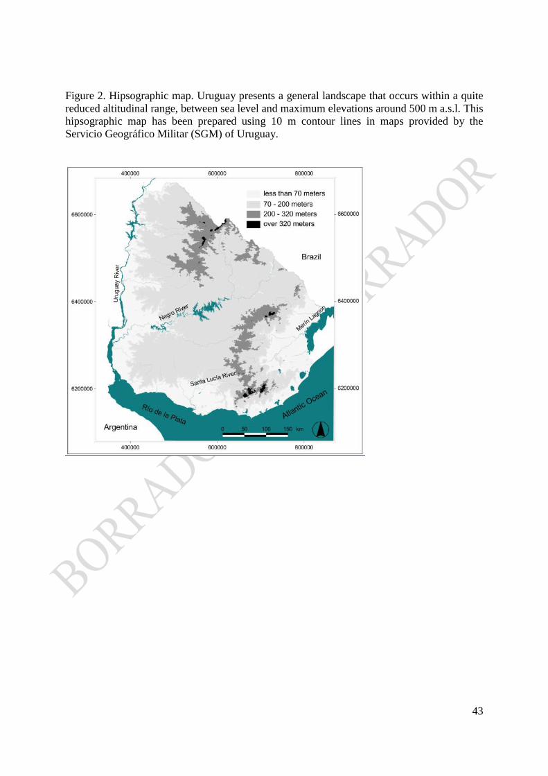
43
Figure 2. Hipsographic map. Uruguay presents a general landscape that occurs within a quite
reduced altitudinal range, between sea level and maximum elevations around 500 m a.s.l. This
hipsographic map has been prepared using 10 m contour lines in maps provided by the
Servicio Geográfico Militar (SGM) of Uruguay.

44
Figure 3. Tectonic domains of Uruguay. Spatial distribution of the Paraná and the Chaco-
Paraná sedimentary basins (Paleozoic to Mesozoic). Modified from Milani (1997).

45
Figure 4. Schematic map showing the geographic distribution of the Paraná Igneous Province
displaying the distribution of high- and low- Ti areas. The main basement highs of the
Basin (Ponta Grossa, Torres and Río Grande archs) are shown. Modified from Piccirillo
and Melfi (1988).

46
Figure 5. Main geological units of Uruguay (Cenozoic cover is not shown): Precambrian
terranes and shear zones; Paleozoic sediments; Mesozoic basaltic flows and rift-related
basins (Modified from Sánchez Bettucci et al. 2010b, after Preciozzi et al. 1985 and Bossi
and Ferrando 2000). Shear Zones: 1) Paso Lugo, 2) Cufré, 3) Mosquitos, 4) Sarandí del
Yí, 5) Sierra Ballena, 6) Cordillera, 7) Rocha, 8) Cueva del Tigre, 9) Fraile Muerto - María
Albina, 10) Tupambaé, 11) Cerro Amaro, 12) Rivera.

47
Figure 6. Approximate location of cratons older than 1.3 Ga in South America and Africa.
(https://commons.wikimedia.org/wiki/File:Cratons_West_Gondwana.svg).

48
Figure 7. a) Regional distribution of Devonian sediment in Uruguay (Durazno Group) more
extensive than established so far. Its surface has been inferred from their spectral response
in satellite imagery (Landsat TM) and field observations.
b) Paleogeographic setting in the framework for the Western Gondwana (the present
approximate location is indicated by a white square).
c) Detalle de ubicación geográfica de Durazno Group.
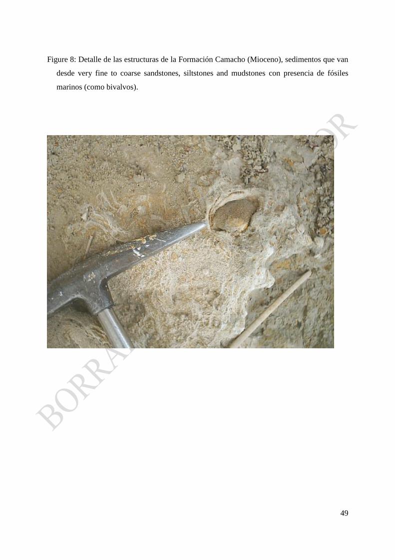
49
Figure 8: Detalle de las estructuras de la Formación Camacho (Mioceno), sedimentos que van
desde very fine to coarse sandstones, siltstones and mudstones con presencia de fósiles
marinos (como bivalvos).

50
Figure 9: En el corte expuesto en la barranca puede observarse un paquete de sedimentos
loessicos con procesos continuos de formación de suelos correspondiente a la Formación
Libertad I (Cuaternario). La línea roja punteada indica el contacto discordante con la
Formación Raigón del Plioceno tardío.
Figure 10. Structural framework of Uruguay. The boundaries of the units have been depicted
following CONEAT (1979) cartography and the topography generated from the 10 m
contour lines in maps provided by the Servicio Geográfico Militar (SGM) of Uruguay,
satellite imagery (Landat TM), photointerpretation of aerial photograph (1:40,000) and
field observation.

51

52
Figure 11. Relieves planos con suelos superficiales de la zona basáltica del norte del país,
formados a partir de un glacis de erosión o transporte.

53
Figure 12. Retroceso de escarpa con perfil cóncavo de retroceso característico de la zona de
lavas basálticas del norte del país.

54
Figure 13. Ejemplos de tors (arriba) y horston (abajo) que se pueden observar coronando
elevaciones en la Sierras de Carapé ubicados sobre rocas graníticas.

55
Figure 14. Foto superior: La línea punteada blanca marca el cambio de superficie en el
paisaje. Topográficamente encima, se expresan los relictos de las dos paleosuperficies,
indicadas por línea punteada azul (la más baja) y roja (la más alta), aparentemente el
pequeño desnivel que las separa a ambas, hace suponer que puedan ser más o menos
cohetaneas
Foto inferior: Vista panorámica desde la paleosuperficie topográficamente más alta,
pueden observarse los otros dos niveles del paisaje.