ancient earthquakes at lake lucerne - uc santa …ward/papers/newscientist.pdfrence) of strong...
TRANSCRIPT

“On Tuesday the 18th of September,1601, shortly before two o’clock in themorning, a strong and truly frighteningearthquake hit the region aroundLucerne.… Nobody could remember asimilar event and even chronicles donot document that the city ever experi-enced a similar occurrence.” So beginsthe eyewitness report of RenwardCysat, a city clerk in Lucerne, Switzer-
land, who amply documented the cata-strophic events that followed one of thestrongest known earthquakes in centralEurope. That temblor caused consider-able damage over much of Switzerlandand was felt in the parts of France, Ger-many and Italy. Seismologists estimatethat this quake, had it been recordedwith modern instruments, would haveranked something like 6.2 on theRichter scale, which would put it onpar with many damaging earthquakesthat have struck near Los Angeles orSan Francisco in recent times.
Of course, Californians expect theground to shake now and again. Buthonestly, who imagines earthquakesthreatening Switzerland? Even theSwiss, who frequently take precautionsagainst avalanches or floods, rarelyconsider the possibility of earthquakesin their neighborhood. Yet diggingback far enough into the historicalrecord, one finds that Switzerland hasin fact experienced several strongearthquakes, ones that brought aboutconsiderable damage to property andloss of life. The 1601 Lucerne event isjust one example. Another is an earth-quake near Basel in 1356, which de-stroyed large parts of that city.
The Basel quake remains thestrongest one ever observed in centralEurope. A similar event today wouldkill and injure many people, and itwould cause widespread and costlydestruction to property. It is, however,difficult to decide how much time andmoney should be invested in earth-quake precautions without knowinghow large or frequent future quakesare likely to be. This is why we are try-ing to help assess Switzerland’s little-known seismic hazards, an effort thatrequires, at minimum, a good under-
standing of the recurrence times of rarebut strong events.
Up until just recently, the catalogueof past earthquakes was based exclu-sively on seismographic measurementsand historic documents. In Switzer-land, the first seismograph was in-stalled in 1911, and the written recordcovers just the last millennium. Thusthe two main sources of information,while valuable, are insufficient to iden-tify places where strong earthquakesstrike, say, every few thousand years.This shortcoming is a real concern, be-cause such lengthy intervals betweenlarge earthquakes is typical for regionssuch as Switzerland, which are locatedaway from the edges of tectonic plates,where most seismic activity takes place.
The only method to document thepast occurrence (and possible recur-rence) of strong earthquakes in such lo-cales is to extend the catalogue ofknown events to prehistoric times. Al-though our stone-age forebears left nodescription of ancient earthquakes, na-ture has recorded much of what tookplace. One just needs to uncover and
38 American Scientist, Volume 92
Ancient Earthquakes at Lake Lucerne
A recent survey of the sediments beneath a Swiss lake reveals a series ofprehistoric temblors
Michael Schnellmann, Flavio S. Anselmetti, Domenico Giardini, Judith A. McKenzie and Steven N. Ward
Michael Schnellmann is currently pursuing a doc-torate in geology at the Swiss Federal Institute ofTechnology (ETH) in Zurich. His thesis advisor,Flavio S. Anselmetti received his Ph.D. from ETHin 1994. He then spent four years in postdoctoraltraining at the University of Miami. There Ansel-metti gained considerable experience studying ma-rine sediments before he returned to his nativeSwitzerland and joined the Geological Institute atETH, where he currently heads the limnogeologylaboratory. Domenico Giardini received his Ph.D. atthe University of Bologna in 1987. Since 1997 hehas been a professor of seismology and geodynamicsat the Institute of Geophysics at ETH and the direc-tor of the Swiss Seismological Service. Between1992 and 1999, he served as director of the GlobalSeismic Hazard Assessment Program for the UN’sInternational Decade for Natural Disaster Reduc-tion. Judith A. McKenzie obtained a doctorate in ge-ology from ETH in 1976. During her training inZurich and later at the University of Florida inGainesville, she investigated the chemical and bio-chemical sedimentation in both modern lakes andoceans. In 1996 she became a professor of earth sys-tem sciences at the Geological Institute at ETH.Steven N. Ward received a Ph.D. in geophysicsfrom Princeton University in 1978, where he spe-cialized in seismic wave theory. After post-doctoralstints at Scripps Institution of Oceanography andHarvard University, he joined the research facultyof the University of California, Santa Cruz in1984. Ward creates computer simulations of dy-namic Earth processes such as earthquakes,tsunamis and tectonic deformations. Address forSchnellmann: Geological Institute, ETH Zurich,Sonneggstrasse 5, CH-8092 Zurich, Switzerland.Internet: [email protected]
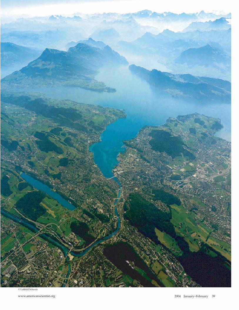
Figure 1. Although many of the people liv-ing and working around Lake Lucerne arekeenly aware of certain natural hazards, suchas avalanches and landslides, few think verymuch about the possibility that a large earth-quake might strike. Yet powerful temblorshave indeed hit this region. One such eventtook place in 1601 and caused considerabledamage. There are no other historical recordsof damaging earthquakes in this area, whichhas made it quite difficult to gauge the likeli-hood of a recurrence. To better estimate thatthreat, the authors undertook to study thesediment that accumulates beneath the lake.Their examination of this natural archive re-vealed that four other large quakes have dis-rupted this scenic locale during the past sev-eral millennia.
2004 January–February 39www.americanscientist.org
© Luftbild Schweiz

interpret the hidden geologic archivesto glean information about seismicevents in the distant past.
Paleoseismologists—the scientistswho specialize in tracking prehistoricearthquakes—often take advantage ofthe fact that moderate to strong seismicshaking leaves characteristic traces ator immediately below ground level.Thus many of our colleagues in thissubfield of geology regularly digtrenches across the surface of activefaults, a procedure that allows them tomeasure the offsets and timing of an-cient quakes. This strategy does not,however, work very well in areas thatare distant from plate boundaries,where surface ruptures are rare anddifficult to identify. In such intra-plateregions, one does better to study fea-tures that record earthquake shaking atone place regardless of the exact posi-tion of the causative fault.
Fortunately, there are many sec-ondary effects of ground shaking: Sta-lactites in caves can break, precarious-ly poised boulders can topple over,steep slopes can become unstable, andsandy soils can be forced to flow as aliquid. Some of these happenings can,however, come about for other rea-sons: A stalactite may break under itsown weight, for example, or heavyrain may induce a landslide. So themain task of paleoseismologists is todistinguish the triggering mechanismand, once a seismic event has beenidentified, to date the structures itleaves in its wake.
Land O’LakesAs any geologist will attest, lake sedi-ments provide some of the most sensi-tive records of past environmental con-ditions, and happily for us, Switzerlandis a country famous for its many majes-tic lakes. Such sediments are especiallyvaluable because they accumulate con-tinuously, year by year, and thus con-tain a complete and often highly de-tailed record of past events since thelake came into existence. In the parts ofLake Lucerne that we studied, a littleless than a millimeter of sediment ac-cumulates each year—and has done sofor the several millennia. The composi-tion of this material reflects much aboutlocal conditions at the time of deposi-tion. Pollen wafted into the lake, for ex-ample, becomes buried in the muddysediment at the bottom, thus recordingthe changing nature of nearby vegeta-tion. And coarse-grained layers docu-ment times when ancient floods sweptsandy debris into the lake.
Earthquakes, too, can leave perma-nent traces on the floors of lakes andoceans, because they often send sedi-ments tumbling down the submergedslopes at the margins of these bodiesof water. The most famous example ofthis nature is probably the GrandBanks earthquake of 1929, which had aRichter magnitude of 7.2 and triggereda giant submarine slide offshore ofNewfoundland. The sudden flow ofsediments down the continental slopecaused a destructive tsunami and cutoff transatlantic communication as a
great mass of soupy mud successivelybroke several submarine telephone ca-bles lying in its path.
Knowing of such events, we rea-soned that the bottom sediments ofvarious Swiss lakes would similarlyhave recorded past episodes of seismicshaking. It took us a while to test thisidea, but after much field and laborato-ry work probing the depths of LakeLucerne, we were able to discern thatfour significant prehistoric earthquakeshad indeed shaken this locale. Here wewould like to recount in some detailhow we mounted our investigation.
A History LessonOur first task in putting together ourresearch program was to consider justwhat sort earthquake signature wouldbe left in the lake sediments. For that,Cysat’s report of the 1601 quake wasinvaluable. On the morning followingthe quake, he and his fellow city offi-cials rode on horseback across thestrand while assessing the damage. Henoted the chaotic scene in his chronicle:
Along the shore of the lake we ob-served ships, timber, planks, tubesand other matters that were notonly drifting in the lake, but havebeen washed ashore and becamedeposited 50 paces [40 to 50 me-ters] behind the regular shorelineand up to two halberds [three tofour meters] above lake level….Closer towards the city, we sawpeople collecting fishes that werethrown onshore…. In Lucerne theships were torn off the piers andbecame pushed far out into thelake. They were drifting rapidlyalthough they were driven neitherby wind, nor rudder or sails….Preternaturally, the big riverReuss [the normal outflow ofLake Lucerne] flew forth and backsix times in an hour.
Cysat further recorded that severaltimes the water in the river separatingthe two parts of the city disappeared al-most completely, so that “one couldcross the riverbed almost by barely get-ting wet feet, as numerous young peo-ple did to commemorate this extraordi-nary event…. Also the [water-driven]mills stopped working.” Cysat also not-ed that “subaqueous mountains andhills one could see and reach with barsduring low lake were broken apart andsucked down into the depth of thelake” and “pieces of meadows were
40 American Scientist, Volume 92
Figure 2. Although most seismic activity takes place at the boundaries between tectonic plates(pink lines), earthquakes of substantial size sometimes strike well within plate interiors. The reddots shows the location of earthquakes with magnitudes of 5.5 or more that have taken placesince 1973. (Plate boundaries are from Rice University’s Discovering Plate Boundaries Project;earthquake epicenters are from the catalog of the U.S. Geological Survey’s National Earth-quake Information Center.)

moved over more than a stone’s throwoff their original positions and deepgaps opened in the ground.”
Reading his account, it was easy forus to imagine that these dramaticevents would have left permanentmarks on the floor of the lake. And in-deed, we were reasonably sure thatthey did, because in the early 1980smembers of the limnogeology labora-tory at the Swiss Federal Institute ofTechnology in Zurich (which oftengoes by its German acronym ETH) haddiscovered two large deposits at thebottom of the lake, the result of sub-aqueous mudslides, which they be-lieved the 1601 quake had caused.
In 1996, soon after taking the reinsto the limnogeology laboratory, one ofus (McKenzie) eagerly picked up onthis line of research. Together with an-other one of us (Anselmetti), she dis-covered numerous slide deposits,many of them deeper (and thus older)than the ones previously studied. Itwas thus clear that these older featuresmust have been deposited in prehis-toric times and that if one could distin-guish slides triggered by earthquakesfrom slides brought about by otherprocesses, these ancient lake depositswould provide an earthquake historyof the area for the past 15 millennia.
Coincidently, at this time anotherone of us (Giardini), director of theSwiss Seismological Service, was look-ing for just such an extended catalogueof earthquakes. Being responsible forthe assessment of seismic hazards for
Switzerland, Giardini needed to knowwhere, when and how often big earth-quakes had taken place. When Ansel-metti reported the findings for LakeLucerne, Giardini quickly appreciatedthat these slide deposits could beviewed as so many smoking guns, in-dicators of hitherto unknown earth-quakes of Switzerland’s distant past.This minor epiphany sparked what re-mains a close collaboration betweenthe Swiss Seismological Survey and theETH limnogeology laboratory.
Having worked out the goal andstrategy of this research project,McKenzie, Anselmetti and Giardini justneeded to find a doctoral student, who,of course, they hoped would do theheavy lifting. So they approached an-other one of us (Schnellmann), just afterhe returned from doing fieldwork in aborax mine in Turkey. On a boat trip onLake Lucerne, Anselmetti convincedSchnellmann to sign on and help un-ravel the secrets hidden below the sur-face of the lake. Although Schnellmannwondered a bit whether this attempt attracking ancient earthquakes wouldprove to be an interesting and mean-ingful topic for the beginning of a sci-entific career, the prospect of spendingthe next few years cruising scenic LakeLucerne (instead of breathing dust in adistant borax mine) made the decisioneasy enough.
Fishing for AnswersIn June, 2001, Schnellman and Ansel-metti procured use of the research ves-
sel that ETH operates on Lake Lucerneand started to explore the bottom sedi-ments using reflection seismology. Thismethod is similar to the sonographythat is used in medicine: Just as doc-tors are able to peek inside humanbodies with ultrasound, geologists canimage the internal structure of the sed-iments that collect beneath bodies ofwater by sending sound waves down-ward from the surface and recordingthe faint echoes that return. In this case,the acoustic transducer (which acts asboth a loudspeaker and microphone)is mounted on the hull of a ship, whereit transmits an acoustic signal into thewater. Some of this sound energybounces back from the floor of the lakeand from distinct depositional layerswithin the lake-bottom muds. The re-flected signal, which is picked up withthe same acoustic transducer andrecorded aboard the research vessel,thus carries information about thestructure of the sediments.
Over many days of fieldwork, wegathered reflection-seismic data over adistance that measured more than 300kilometers in all. Following a zigzagcourse, we collected soundings over adense grid of survey lines, which al-lowed us to piece together a three-dimensional picture of the lake-bottomsediments after we returned to the lab.In pouring over our data, we foundmuch evidence for subaqueous massmovements. These traces were eitherfailure scars on slopes, marking wherelarge chunks of material had fallen
2004 January–February 41www.americanscientist.org
two-
way
trav
eltim
e
dept
h
0
N210
kilometers
figure 4 top
figure 4bottom
Figure 3. Structural details in the sediments of Lake Lucerne could becharted using reflection seismic profiling. This method uses an acoustictransducer affixed to the hull of a survey boat to emit a pulse of sound en-ergy, which partially reflects from the lake bottom and from the interfacesbetween sedimentary layers of distinctive composition (far left). Thesame transducer picks up these faint echoes, which are recorded elec-tronically. Repeating this sounding procedure at closely spaced intervalsand plotting the results side by side (left) produces a facsimile of thestructure within the lake-bottom sediments. The authors conducted seis-mic profiling while cruising some 300 kilometers over a zigzag coursethat allowed them to chart the western portion of the lake (top).

away, or buried slide deposits, wherethe slumped material had settled. Suchaccumulations can easily be recognizedon the seismic sections because nor-mal, undisturbed lake sediments showclear horizontal layering, whereas theintensely reworked slide deposits givea chaotic signature resembling a static-filled TV screen.
Having dozens of closely spacedcross-sections in hand made it easy totrack prominent layers and to map theextent of individual slumps throughoutthe fraction of the lake that we had sur-veyed. (Lake Lucerne contains several
distinct basins, and we decided not toexamine those with adjacent riverdeltas, which we knew could be thesource of slump deposits that didn’thave anything to do with earthquakes.)At this point we realized that many ofthe newly discovered deposits were atexactly the same level as the ones theformer ETH lake research group had al-ready detected and associated with the1601 earthquake. Indeed, the horizoncorresponding to this event contains atleast 13 widespread slumps, indicatingthat this quake triggered synchronoussliding all over the lake. What is more,
we found that in the center of two well-separated sub-basins, these slide de-posits are overlain by layers of homo-geneous mud that are as much as twometers thick—a result, no doubt, of agreat mass of sediment that was heldin suspension in the waters of the lakefor a short time after the quake beforefinally settling out.
Figuring that prehistoric earth-quakes with magnitudes equal or larg-er than the 1601 event would have leftsimilar deposits, we examined theseismic cross-sections with great care.And we quickly discovered a horizon
42 American Scientist, Volume 92
10 meters
200 meters
south north
west east
10 meters
200 meters
Figure 4. Seismic reflection profiles obtained over two cruise tracks reveal distinctive deposits indicative of slumping along the margins of thelake (colored zones). The top panel shows a north-to-south section that cuts through the center of a large deep basin (red line at right in the toppanel of Figure 3). The bottom panel shows an east-to-west section near the western margin of the lake (red line at left in Figure 3). The charac-ter of the seismic pattern within the colored zones is somewhat chaotic, like a static-filled television screen, whereas the normal sedimentarylayers outside them produce continuous light and dark lines. Guided by these images and many of the other seismic sections they obtained forLake Lucerne, the authors retrieved sediment cores from key positions, including the center of the large basin (black line in upper panel). Thisroughly 10-meter-long core penetrated three slump-induced deposits of different ages (pink, purple, green).

some three meters below the floor ofthe lake that contains 16 individualslumps. Thick, homogenous mud bod-ies sit directly on top of these depositsin three different sub-basins. We thussuspected that we were seeing the ves-tiges of some enormously violent pre-historic quake.
Still, we wondered a bit at the timewhether all this slumping could havehappened for a more mundane reason.But we made an observation that gaveus confidence that an earthquake wasindeed at work here: Remnants ofthese ancient mud slides were not onlyfound at the foot of the slopes that linethe margins of the lake, but they alsoshowed up next to two submergedhills, one that crests about 85 metersbelow the surface of the lake. Morecommonplace events, such as storm-induced waves or pervasive floodingcould conceivably trigger slidesaround the margin of the lake, butthey would not have affected the sta-bility of lake-bottom slopes that are farfrom the shore and under 85 meters ofwater. There was no doubt about it:We had found the traces of an ancientearthquake.
Sizing Up the CatchFurther probing of our seismic recordsrapidly turned up evidence for threemore prehistoric quakes of significantmagnitude (that is, ones big enough tocause multiple slides). But just howpowerful were these ancient quakes?That has remained a difficult questionto answer. We can’t even rely on whatwould at first blush seem a reasonablesurmise: that the bigger the earth-quake, the more sediment gets shiftedaround. We hesitate to use such logicbecause the biggest slide deposit weidentified in our studies (containingsome 17,000,000 cubic meters of mud)was probably caused by a very smallquake—or perhaps by an entirely dif-ferent process. We believe this to betrue because this huge slump repre-sents an isolated occurrence; no otherslope failures took place at that timeelsewhere in the lake.
Although we can’t estimate themagnitude of these quakes in anyquantitative way, we can be reasonablysure that they must have been fairlylarge ones. After all, this area ofSwitzerland has experienced manysmall earthquakes over the past centu-ry (some five events ranking at magni-tude-5 or more have been recorded, for
example), and none of those causedmultiple slope failures around the mar-gins of the lake. So we were clearly see-ing the results of big earthquakes inour seismic records.
When did these quakes happen?This question has proved easier to an-swer—although doing so required usto do a lot more fieldwork. To attachdates to these events, we needed to re-cover sediment samples from the vari-ous slide deposits, which lie deep be-low the floor of the lake, which itself issubmerged under some 150 meters ofwater. We therefore went back to thelake with a small pontoon boat, really araft, and a specially designed samplingdevice called a Kullenberg corer—inthis case a 12-meter-long tube of steelwith a 300-kilogram lead weight ontop. To take sediment cores, we slowlylowered this ungainly probe throughthe water toward the bottom using asteel cable attached to a powerfulwinch. When the corer reached 10 me-ters above the lake floor, a triggeringmechanism allowed it to fall freely therest of the way. The tube was thus dri-ven deep into the sediments, filling itwith mud, which was held in place bya springy device on the business endof the corer that prevents the sedimentfrom sliding back out.
Guided by our many seismic cross-sections, we retrieved sediment coresfrom various slide deposits as well asfrom undisturbed sediments. Afterseven days of hard and sometimesmessy work, we returned to our lab inZurich with eight sediment cores, each8 to 10 meters in length, from two dif-ferent sub-basins.
For geologists, the splitting andopening of recovered cores is a much-anticipated event. And indeed, itproved thrilling. Having the lake de-posits revealed before our eyes waslike traveling back in time, experienc-ing the various swings in climate andchanges in local vegetation, seeing thetangible evidence of ancient stormsand floods—and, of course, earth-quakes. They showed themselves astortuously folded slide deposits withoverlying beds of homogeneous mud.These distinctive packages stood outclearly from the thin horizontal layersfound elsewhere in the sediment.
To find the age of each slide deposit,we extracted leaves and small pieces ofwood from the undisturbed sedimentdirectly overlying it. The age of this or-ganic material could then be deter-
2004 January–February 43www.americanscientist.org
1601 A.D.event
470 B.C.event
7820 B.C.event
Figure 5. Examination of the retrieved sedi-ment cores allowed the authors to confirmtheir interpretation of their seismic sectionsand to obtain organic material suitable forage dating. Images of the sediment recoveredfrom the position shown in the previous fig-ure (right, here placed in their proper strati-graphic position and stretched horizontallyfor clarity) show a good correspondence withthe results obtained from seismic profiling atthis position (left). The pink layer is a slumpdeposit laid down in 1601, during and shortlyafter a historic earthquake. The purple layershows a thinner slump-induced deposit thatformed earlier, in 470 B.C. according to radio-carbon dating. The green layer represents ayet-older event, one that produced only a sin-gle slump deposit and was thus probably notan earthquake.
mined using radiocarbon dating. Fur-ther clues about the antiquity of thesedeposits came from two layers of vol-canic ash that we found in the sedi-ments. We were able to tie these ashlayers to prehistoric volcanic eruptionsin eastern France and western Ger-many. Combining all the dates, for theorganic material and for the two hori-zons of volcanic ash, we calculatedages for the slide deposits and the fourearthquakes that caused them: Theyhappened in about 470 B.C., 7,820 B.C.,11,960 B.C. and 12,610 B.C. We had suc-cessfully produced a timeline for pre-historic seismic events in centralSwitzerland.
Kowabunga!Our study of the sediments of LakeLucerne revealed a long history of seis-mic shaking in the area, but it did notanswer an important question raisedby Cysat’s account of the 1601 earth-quake: Why did the water in the lakeshift as it did? Can underwater mud-slides of the size we observed displaceenough water to generate 4-meter-highwaves? And do such waves, whichmight be considered tsunamis of sorts,pose significant hazards to lakeshorecommunities?
To estimate the type and amplitudeof waves one would expect, Schnell-man and Anselmetti approached an-other one of us (Ward), an expert in thenumerical modeling of tsunamis.These destructive water waves gener-ally result from large displacements ofsediments at the sea floor. Whereas theoccurrence of destructive tsunamis inthe ocean has long been investigatedand is relatively well understood, sim-
ilar water movements in lakes havebarely been studied.
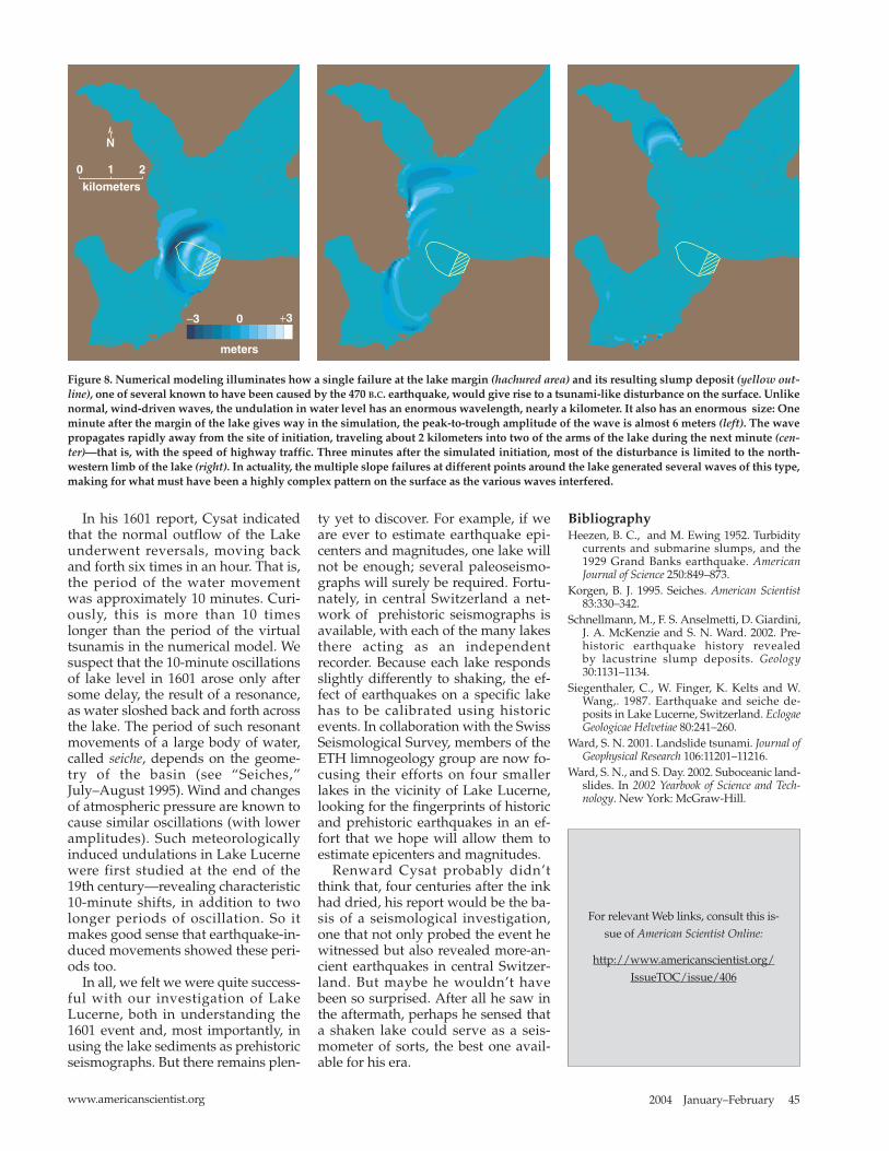
To better comprehend how earth-quake-triggered mass movements inLake Lucerne can generate dangerous-ly large waves, we modeled the tsuna-mi-like effect of the subaqueous slide of470 B.C. We chose to study this particu-lar event because we had mapped ingood detail one of the places where thebottom had given way, the pathway ofsediment movement and the geometryof the resultant deposit, which, we pre-sumed, would allow for an accurate re-construction of this ancient disruption.Our reflection-seismic data showedthat the slide broke loose leaving a 9-meter-high scar behind on the marginof the lake, that it transported a volumeof sediment equivalent to a giant cubewith edges 100 meters long and thatsome of this mud moved as much as1,500 meters laterally.
The numerical model showed waveshigher than three meters striking theshore opposite the site of failure withina minute after initiation of the slide.The modeled waves had wavelengthsgreater than a kilometer, which is en-tirely different from the situation withordinary wind-induced surface waves.In this respect, the computer-simulatedwaves indeed resemble mountains ofwater rising in the center of the sub-basins, just as eyewitnesses to theevents of 1601 long ago described. Tryto imagine the tempestuous state of thelake at that time, with large chunks ofbottom sediment giving way at vari-ous points around the lake and the re-sulting tsunamis superimposing. Thewater movements must truly havebeen frightening.
44 American Scientist, Volume 92
N210
kilometers
historic (1601 A.D.)earthquake
prehistoric (470 B.C.)earthquake
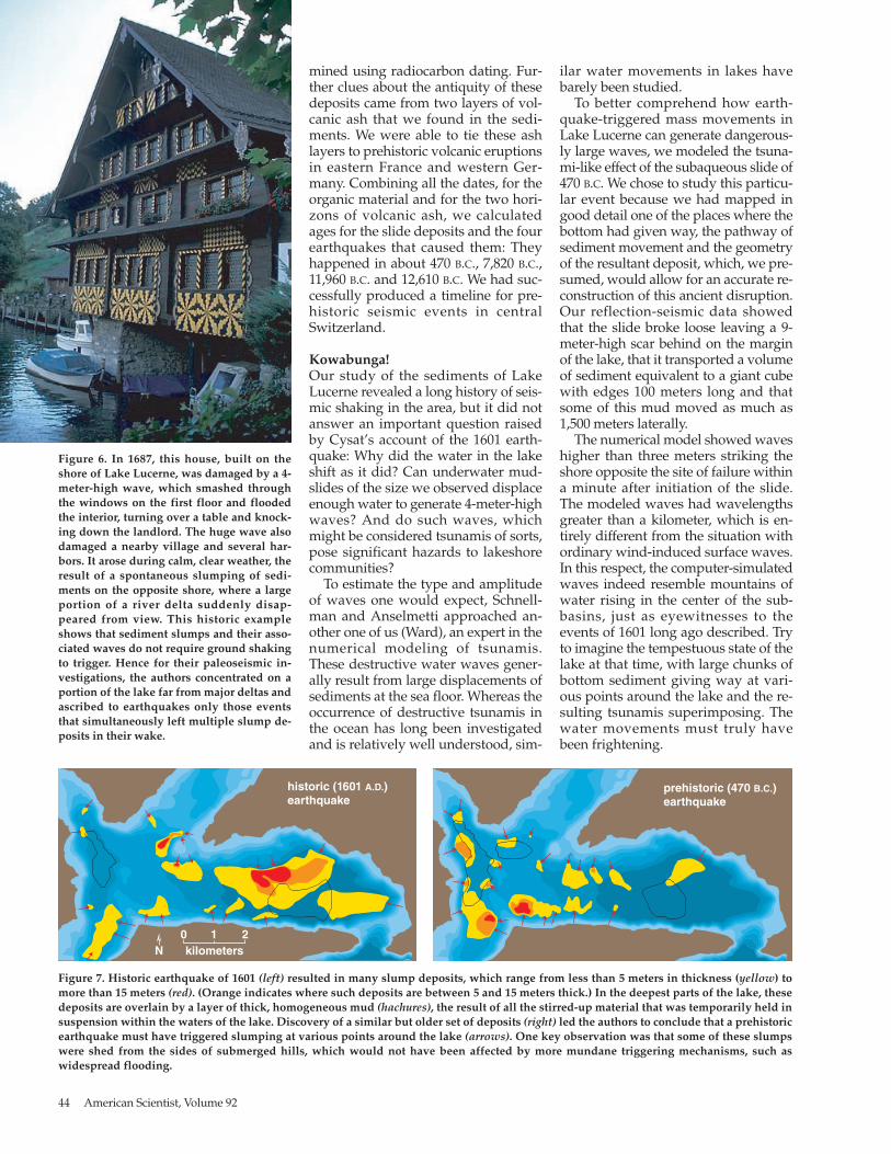
Figure 7. Historic earthquake of 1601 (left) resulted in many slump deposits, which range from less than 5 meters in thickness (yellow) tomore than 15 meters (red). (Orange indicates where such deposits are between 5 and 15 meters thick.) In the deepest parts of the lake, thesedeposits are overlain by a layer of thick, homogeneous mud (hachures), the result of all the stirred-up material that was temporarily held insuspension within the waters of the lake. Discovery of a similar but older set of deposits (right) led the authors to conclude that a prehistoricearthquake must have triggered slumping at various points around the lake (arrows). One key observation was that some of these slumpswere shed from the sides of submerged hills, which would not have been affected by more mundane triggering mechanisms, such aswidespread flooding.
Figure 6. In 1687, this house, built on theshore of Lake Lucerne, was damaged by a 4-meter-high wave, which smashed throughthe windows on the first floor and floodedthe interior, turning over a table and knock-ing down the landlord. The huge wave alsodamaged a nearby village and several har-bors. It arose during calm, clear weather, theresult of a spontaneous slumping of sedi-ments on the opposite shore, where a largeportion of a river delta suddenly disap-peared from view. This historic exampleshows that sediment slumps and their asso-ciated waves do not require ground shakingto trigger. Hence for their paleoseismic in-vestigations, the authors concentrated on aportion of the lake far from major deltas andascribed to earthquakes only those eventsthat simultaneously left multiple slump de-posits in their wake.
In his 1601 report, Cysat indicatedthat the normal outflow of the Lakeunderwent reversals, moving backand forth six times in an hour. That is,the period of the water movementwas approximately 10 minutes. Curi-ously, this is more than 10 timeslonger than the period of the virtualtsunamis in the numerical model. Wesuspect that the 10-minute oscillationsof lake level in 1601 arose only aftersome delay, the result of a resonance,as water sloshed back and forth acrossthe lake. The period of such resonantmovements of a large body of water,called seiche, depends on the geome-try of the basin (see “Seiches,”July–August 1995). Wind and changesof atmospheric pressure are known tocause similar oscillations (with loweramplitudes). Such meteorologicallyinduced undulations in Lake Lucernewere first studied at the end of the19th century—revealing characteristic10-minute shifts, in addition to twolonger periods of oscillation. So itmakes good sense that earthquake-in-duced movements showed these peri-ods too.
In all, we felt we were quite success-ful with our investigation of LakeLucerne, both in understanding the1601 event and, most importantly, inusing the lake sediments as prehistoricseismographs. But there remains plen-
ty yet to discover. For example, if weare ever to estimate earthquake epi-centers and magnitudes, one lake willnot be enough; several paleoseismo-graphs will surely be required. Fortu-nately, in central Switzerland a net-work of prehistoric seismographs isavailable, with each of the many lakesthere acting as an independentrecorder. Because each lake respondsslightly differently to shaking, the ef-fect of earthquakes on a specific lakehas to be calibrated using historicevents. In collaboration with the SwissSeismological Survey, members of theETH limnogeology group are now fo-cusing their efforts on four smallerlakes in the vicinity of Lake Lucerne,looking for the fingerprints of historicand prehistoric earthquakes in an ef-fort that we hope will allow them toestimate epicenters and magnitudes.
Renward Cysat probably didn’tthink that, four centuries after the inkhad dried, his report would be the ba-sis of a seismological investigation,one that not only probed the event hewitnessed but also revealed more-an-cient earthquakes in central Switzer-land. But maybe he wouldn’t havebeen so surprised. After all he saw inthe aftermath, perhaps he sensed thata shaken lake could serve as a seis-mometer of sorts, the best one avail-able for his era.
BibliographyHeezen, B. C., and M. Ewing 1952. Turbidity
currents and submarine slumps, and the1929 Grand Banks earthquake. AmericanJournal of Science 250:849–873.
Korgen, B. J. 1995. Seiches. American Scientist83:330–342.
Schnellmann, M., F. S. Anselmetti, D. Giardini,J. A. McKenzie and S. N. Ward. 2002. Pre-historic earthquake history revealed by lacustrine slump deposits. Geology30:1131–1134.
Siegenthaler, C., W. Finger, K. Kelts and W.Wang,. 1987. Earthquake and seiche de-posits in Lake Lucerne, Switzerland. EclogaeGeologicae Helvetiae 80:241–260.
Ward, S. N. 2001. Landslide tsunami. Journal ofGeophysical Research 106:11201–11216.
Ward, S. N., and S. Day. 2002. Suboceanic land-slides. In 2002 Yearbook of Science and Tech-nology. New York: McGraw-Hill.
2004 January–February 45www.americanscientist.org
0 1 2kilometers
N
0 +3–3
meters
Figure 8. Numerical modeling illuminates how a single failure at the lake margin (hachured area) and its resulting slump deposit (yellow out-line), one of several known to have been caused by the 470 B.C. earthquake, would give rise to a tsunami-like disturbance on the surface. Unlikenormal, wind-driven waves, the undulation in water level has an enormous wavelength, nearly a kilometer. It also has an enormous size: Oneminute after the margin of the lake gives way in the simulation, the peak-to-trough amplitude of the wave is almost 6 meters (left). The wavepropagates rapidly away from the site of initiation, traveling about 2 kilometers into two of the arms of the lake during the next minute (cen-ter)—that is, with the speed of highway traffic. Three minutes after the simulated initiation, most of the disturbance is limited to the north-western limb of the lake (right). In actuality, the multiple slope failures at different points around the lake generated several waves of this type,making for what must have been a highly complex pattern on the surface as the various waves interfered.
For relevant Web links, consult this is-sue of American Scientist Online:
http://www.americanscientist.org/IssueTOC/issue/406