anc interim meeting country report- r. of...
TRANSCRIPT
ANC Interim meetingCountry report- R. of Macedonia
Dusko Mukaetov, Nina Aleksovska, Ordan Cukaliev

General characteristics of the Republic of
Macedonia
• Macedonia is locatedin the central part ofthe Balkan Peninsula.It is a landlockedcountry having anarea of 25 713 km2,representing one ofthe smallest countriesin Europe,
• It is bordered bySerbia and Kosovo tothe north, Bulgaria tothe east, Greece tothe south, andAlbania to the west,

Administrative division
• Macedonia (MK) is included in the Nomenclature of Territorial Units for Statistics (NUTS).
• NUTS-1: MK0 FUR Macedonia
• NUTS-2: MK00 FUR Macedonia
• NUTS-3: 8 Statistical regions
– MK001 Vardar
– MK002 Eastern
– MK003 Southwestern
– MK004 Southeastern
– MK005 Pelagonia
– MK006 Polog
– MK007 Northeastern
– MK008 Skopje

Administrative division
• There are two Local Administrative Levels (LAU)
Level - LAU1: municipalities;
Level - LAU2: settlements.

Topography
Large and highmountainousmassifscharacterizethe country’stopography.
The averageelevation is829,7 m abovesea level.Mean slope is15,1o (33,56%).

Relief distribution
Relief distribution accordingto elevation is as follows:
- valley relief (300 m a.s.l.) –9.5 %;
- valley-hilly relief (301-500 ma.s.l.) – 15.9 %;
- hilly-mountain relief (501-1 000 m a.s.l.) – 44.0 %;
- mountain relief (1 000-1 500m a.s.l) – 21.3 %; highmountain relief (>1 500 ma.s.l.) – 9.3 %.
The country has 14mountain peaks higher then2 000 m
The highest peak, the 2 764meter-high Golem Korab

Slope Area
0-5o 24.60%
5-10o 18.80%
10-20o 31.50%
20-30o 18,00 %
30-40o 6,00 %
>40o 1.10%
• There are flat river valleys and plains inter-connected by passes or deep ravines.
• The slope in the valleys is gentle, but on the mountain there is very steep slope (more
than 30 %).
SLOPE

Serbian-Macedonian massif
Povardarie zone
Pelagonija plane
Western Macedonia zone
Geotectonic zones

Geology
• Numerous different
geological formations,
which differ on small
distances in their age,
mineralogical and
petrologic composition,
results in high
heterogeneity of the
soil cover,
• The mountainous
region is generally
composed of compact
(solid) rocks with
eruptive or
metamorphic origin,
• The valleys are mainly
filled with clastic
mechanical sediments
which are usually loose
or weakly connected,
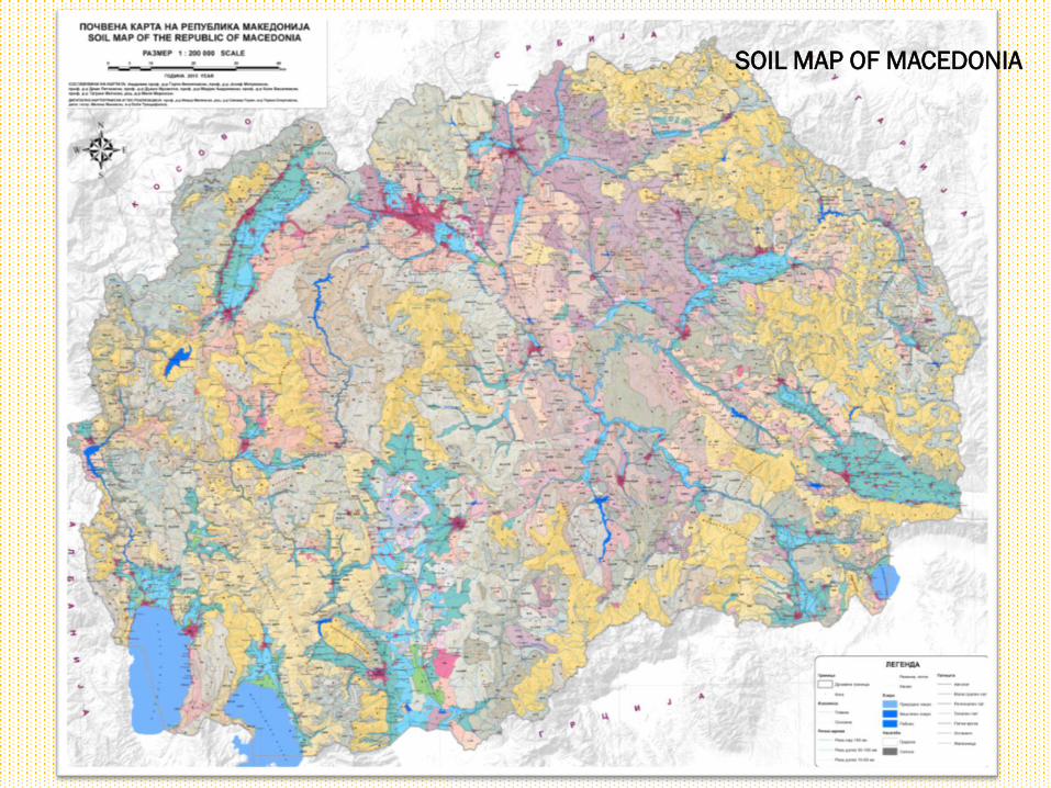
SOIL MAP OF MACEDONIA

Soil cover distribution
Soil cover can be divided in a four major zones:
a) soils of the plains,
b) b) soils of the sloppy terrains,
c) c) soils of the hilly terrains and lake terraces,
d) d) soils of the mountainous regions.
Plains
Hilly areas and lake terraces
Sloppy areas
Mountainous regions

Soil cover distribution
15,91
3,60
1,70
5,70
4,05
5,95
0,00
2,00
4,00
6,00
8,00
10,00
12,00
14,00
16,00
18,00
Mountaneous soils, %
0,26
3,87 3,52
15,11
7,26
4,34 4,04
1,992,92 3,43
0,00
2,00
4,00
6,00
8,00
10,00
12,00
14,00
16,00
Soils of the undulated hilly relief, %
5,46
0,730,27 0,38 0,30
5,35
0,56
0,00
1,00
2,00
3,00
4,00
5,00
6,00
Soils of the plains, %

Land cover
• CORINE Land cover is
the only available and
most relevant source of
information on a country,
•According to CORINE
LCU classification – level
1, forests and semi-
natural areas cover
60,2% of the whole
territory, while
agricultural land 36,5%),
•The Land cover data
presented in following
map and table is based
on CORINE Land cover
Project for 2006.

Land cover - changes
Class 2000 г. (ha) % 2006 г. (ha) % Change %
Artificial surfaces 38 900 1.5 41 480 1.6 +0,1
Agricultural areas 973 900 37.8 939 013 36.5 -1,3
Forest and seminatural areas 1587 900 61.7 1 548 855 60.2 -2.5
Wetlands 59 100 2.2 56 444 2.1 -0,1
Water bodies 2 000 0.07 2 015 0.08 0,01

Land use
Land use distribution1998 2012 Changes
‘98-‘12in %Area in ha. Area in % Area in ha. Area in %
Total land 2.543.216 100 2.571.300 100
1. Productive land 2.312.390 90.92 2.183.766 84,93 -5,99
1.1. Forest land 1.021.139 40.15 981.812 38,18 -1,97
1.2. Agriculture land 1.291.251 50.77 1.120.213 43,57 -7,2
1.2.1. Pastures 633.562 24.91 608.176 23,65 -1,26
1.2.2. Cultivated land 657.689 25.86 511.316 19,89 -5,97
1.2.2.1. Arable lands and gardens 554.162 21.79 414.829 16,13 -5,66
1.2.2.2. Orchards 19.633 0.77 14.469 0,56 -0,21
1.2.2.3. Vineyards 29.298 1.15 20.695 0,80 -0,35
1.2.2.4. Natural meadows 54.596 2.15 61.323 2,38 0,23
2. Unproductive land 230.826 9.08 387.534 15,07 5,99
2.1. Waters 87.493 3,44 81.741 3,18 -0,26
2.2. Other 143.333 5,64 305.793 11,89 6,25
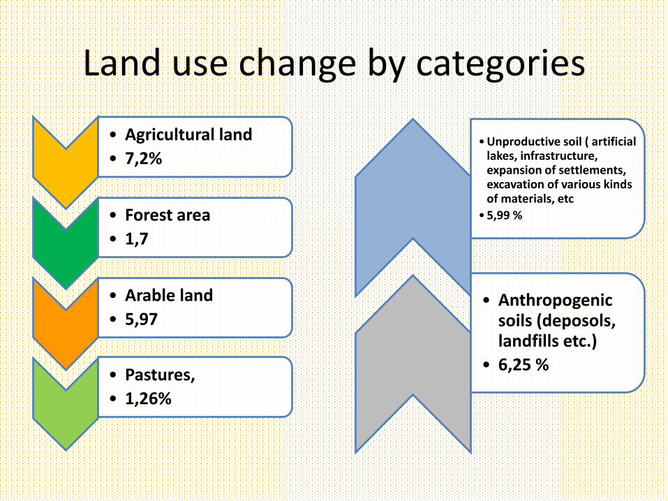
Land use change by categories
• Agricultural land
• 7,2%
• Forest area
• 1,7
• Arable land
• 5,97
• Pastures,
• 1,26%
• Unproductive soil ( artificial lakes, infrastructure, expansion of settlements, excavation of various kinds of materials, etc
• 5,99 %
• Anthropogenic soils (deposols, landfills etc.)
• 6,25 %

METHODOLOGY

ANC delineation methodology
• Compilation of identified existing data sets needed for delineation of ANC,
• Definition of climate parameters, time span and resolution,• Development of high resolution raster maps for the main
climate parameters (temperature and precipitation),• Development of high resolution raster maps for climate
indices (aridity index, De Marthone, Lang etc.),• Collection, evaluation and harmonization of soil data sets :• Digitalization of analog soil legacy data (scanning and
vectorization),• Selection of appropriate georeferencing system and
suitable software packages, models and procedures for geostatistical analysis,

ANC delineation methodology
• Elaboration of raster maps for soil properties indicated among the criteria for ANC delineation,
• Integration of country specific criteria for creation of final derivate with identified and delineated ANC,
• Validation of the final product by use of auxiliary data sets and correction of its boundaries (e.g. orthopotos, topo-maps etc.)

DATA AVAILABILITY
23

MASIS - Main Available Data
• Soil profile data (‘legacy’)
• Soil map – SMU based; (uniform list of soil types /STU, no STU
attributes,…)
• DEM 15m derivates
• Average Year Temperatures
• Average Year Precipitation
• Land use - Corine Land cover
• Geology – raster vectorised in a FAO project• Other, less important
24

Soil profile dataset
• 4300 soil profile locations with coordinates available in the database
• 11,071 horizons; most populated properties:
25

Soil profiles location

Horizon dataset
• A part of the soil horizon dataset
27
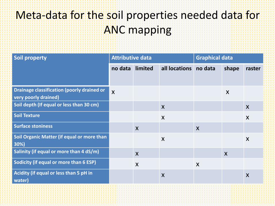
Meta-data for the soil properties needed data for ANC mapping
Soil property Attributive data Graphical data
no data limited all locations no data shape raster
Drainage classification (poorly drained or
very poorly drained) x x
Soil depth (If equal or less than 30 cm) x xSoil Texture x xSurface stoniness x xSoil Organic Matter (if equal or more than
30%) x x
Salinity (if equal or more than 4 dS/m) x xSodicity (if equal or more than 6 ESP) x xAcidity (if equal or less than 5 pH in
water)x x

AREC – Main available data
• - digital topographic maps in scale 1:25000,

AREC – Main available data
• - digital terrain model (DTM),
DTM 5m DTM 20m
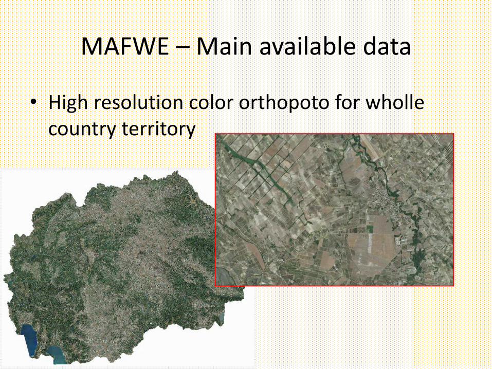
MAFWE – Main available data
• High resolution color orthopoto for wholle country territory

MAFWE – Main available data
• Land Parcel identification system (Lpis)
• The LpIS data base in fact keeps records for the agricultural land which is actually under cultivation ,
• Lpis data keeps graphical and numerical record for crop class,
Data gaps, problems, and solutions
• All digital data bases are created within various institutions for different goals,
• There is serious lack in networking of the created digital data bases,
• The quality of stored data in many cases in not sufficient, in terms of its consistency, continuity and format,
• Data availability in many cases is significant constrain, due to internal procedures and politics of the Institutions possessing data,
Data gaps, problems, and solutions
According the methodology applied in the EU for defining ANCs, in case of R. of Macedonia the existing data sets stored within MASIS can meet the most of the specific criteria for delineation of ANCs,
The only missing soil parameters are:
• exact measurements of “poorly or very poorly drained soils” water lodged within soil profile for a certain period of time). This criterion will be overcome by use of the second option, or through identification of gleyic soils out of the existing digital soil map.
• “Unfavourable soil texture and stoniness”. Very limited data for the stoniness. Soil texture classes can be calculated on the base of existing data for soil texture fractions, like: soil, clay and sand,
• no records for “soil sodicity”, due to what the third criterion “poor chemical properties” will be calculated on the base of delineation of areas under saline and alkaline soils.

Thank you for your attention!Dusko Mukaetov
www.zeminst.edu.mk
Nina Aleksovska, Dusko
Mukaetov Ordan Chukaliev
Andrevlje 30 June-1July 2016

1. Region with sub-Mediterranean climate (50 - 150 m)
2. Region with moderate-continental-sub-Mediterranean
climate (150-300m)
3. Region with hot continental climate (600 - 900 m)
4. Region with cold continental climate(900 - 1100 m)
5. Region with sub-forest-continental-mountainous
climate(1100-1300 m)
6. Region with forest-continental mountainous climate(1300
- 1650 m)
7. Region with sub-alpine mountainous climate (1650 -
2250 m)
8. Region with alpine mountainous climate ( hs >2250 m)


• 1891 until 1899 - meteorological measurements in Skopje
• 1986 until 1911 measurements in Bitola
• 1914-1918 meteorological measurements on 3 sites:
Bitola, Prilep and Udovo (1st WW, for army needs)
• 1923 - some organized and continuous meteorological
measurements were established
• 1947 - the “Hydrometeorological Service of People
Republic of Macedonia” and network of meteorological
stations were established.
• 1978 it becomes Republic Hydrometeorological Service,
a governmental organization of special importance for
carrying out work in meteorology and hydrology

• 1991 Independence and Member of WMO
• 1992 Law on on Hydrometeorological matters
Hydrometeorological Service Independent
institutions
• 2000 – Hydrometeorological Service is part of
Ministry of Agriculture Forestry and Water Economy
• 1991-present Hydrometeorological Service
represents a national authority for meteorology and
hydrology

A state meteorological station network with
professional observers:
• 19 main meteorological stations and
• 2 meteorological radar hail suppression centres.
Beside this there is established a network of
stations with part-time observers:• 7 climatological stations,
• 103 precipitation and
• 24 phenological stations.
Automatic meteorological stations• total number is 14

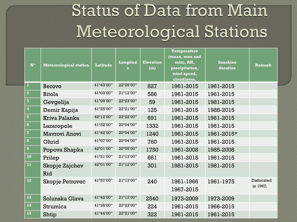
N° Meteorological station LatitudeLongitud
e
Elevation
(m)
Temperature
(mean, max and
min), RH,
precipitation,
wind speed,
cloudiness,
Sunshine
durationRemark
1 Berovo 41°43’00” 22°25’00” 827 1961-2015 1961-20152 Bitola 41°03’00” 21°12’00” 586 1961-2015 1961-20153 Gevgelija 41°09’00” 22°23’00” 59 1961-2015 1981-20154 Demir Kapija 41°25’00” 22°21’00” 125 1961-2015 1988-20155 Kriva Palanka 42°12’00” 22°22’00” 691 1961-2015 1961-20156 Lazaropole 41°32’00” 20°04’00” 1332 1961-2015 1961-20157 Mavrovi Anovi 41°42’00” 20°04’00” 1240 1961-2015 1961-2015*8 Ohrid 41°07’00” 20°04’00” 760 1961-2015 1961-20159 Popova Shapka 42°01’00” 20°05’00” 1750 1961-2008 1985-200810 Prilep 41°21’00” 21°13’00” 661 1961-2015 1961-201511 Skopje Zajchev
Rid
42°01’00” 21°12’00” 301 1981-2015 1981-2015
12 Skopje Petrovec 41°57’00” 21°13’00” 240 1961-1966
1967-2015
1961-1975 Dislocated
in 1967;
13 Solunska Glava 41°42’00” 21°12’00” 2540 1973-2009 1973-200914 Strumica 41°26’00” 22°23’00” 224 1961-2015 1966-201515 Shtip 41°44’00” 22°21’00” 322 1961-2015 1961-2015
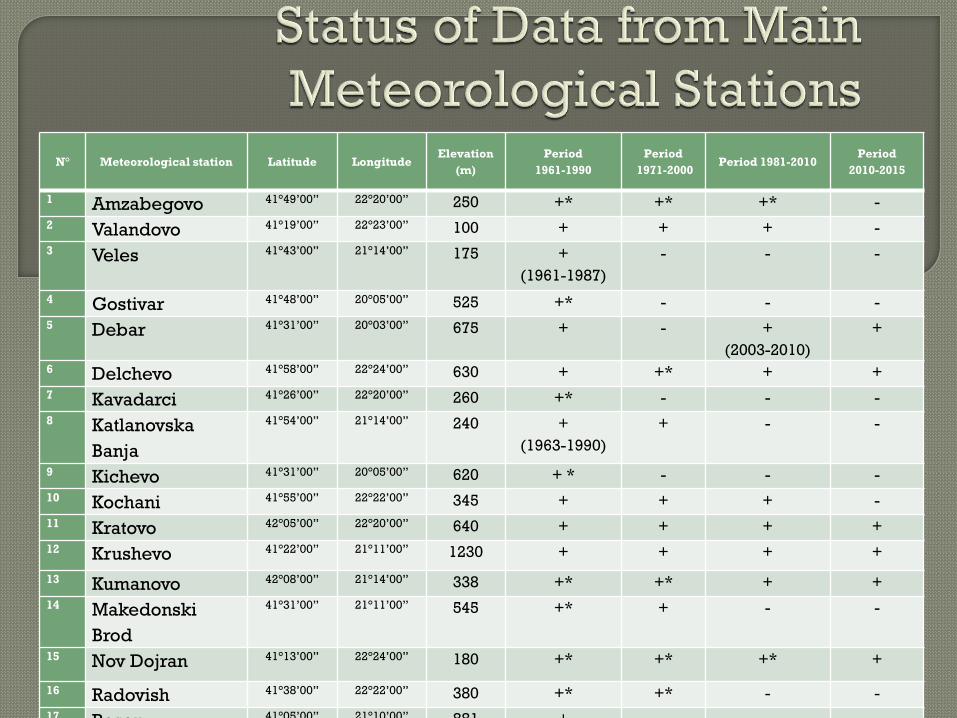
N° Meteorological station Latitude LongitudeElevation
(m)
Period
1961-1990
Period
1971-2000Period 1981-2010
Period
2010-2015
1 Amzabegovo 41°49’00” 22°20’00” 250 +* +* +* -
2 Valandovo 41°19’00” 22°23’00” 100 + + + -
3 Veles 41°43’00” 21°14’00” 175 +
(1961-1987)
- - -
4 Gostivar 41°48’00” 20°05’00” 525 +* - - -
5 Debar 41°31’00” 20°03’00” 675 + - +
(2003-2010)
+
6 Delchevo 41°58’00” 22°24’00” 630 + +* + +
7 Kavadarci 41°26’00” 22°20’00” 260 +* - - -
8 Katlanovska
Banja
41°54’00” 21°14’00” 240 +
(1963-1990)
+ - -
9 Kichevo 41°31’00” 20°05’00” 620 + * - - -
10 Kochani 41°55’00” 22°22’00” 345 + + + -
11 Kratovo 42°05’00” 22°20’00” 640 + + + +
12 Krushevo 41°22’00” 21°11’00” 1230 + + + +
13 Kumanovo 42°08’00” 21°14’00” 338 +* +* + +
14 Makedonski
Brod
41°31’00” 21°11’00” 545 +* + - -
15 Nov Dojran 41°13’00” 22°24’00” 180 +* +* +* +
16 Radovish 41°38’00” 22°22’00” 380 +* +* - -
17 Resen 41°05’00” 21°10’00” 881 + - - -
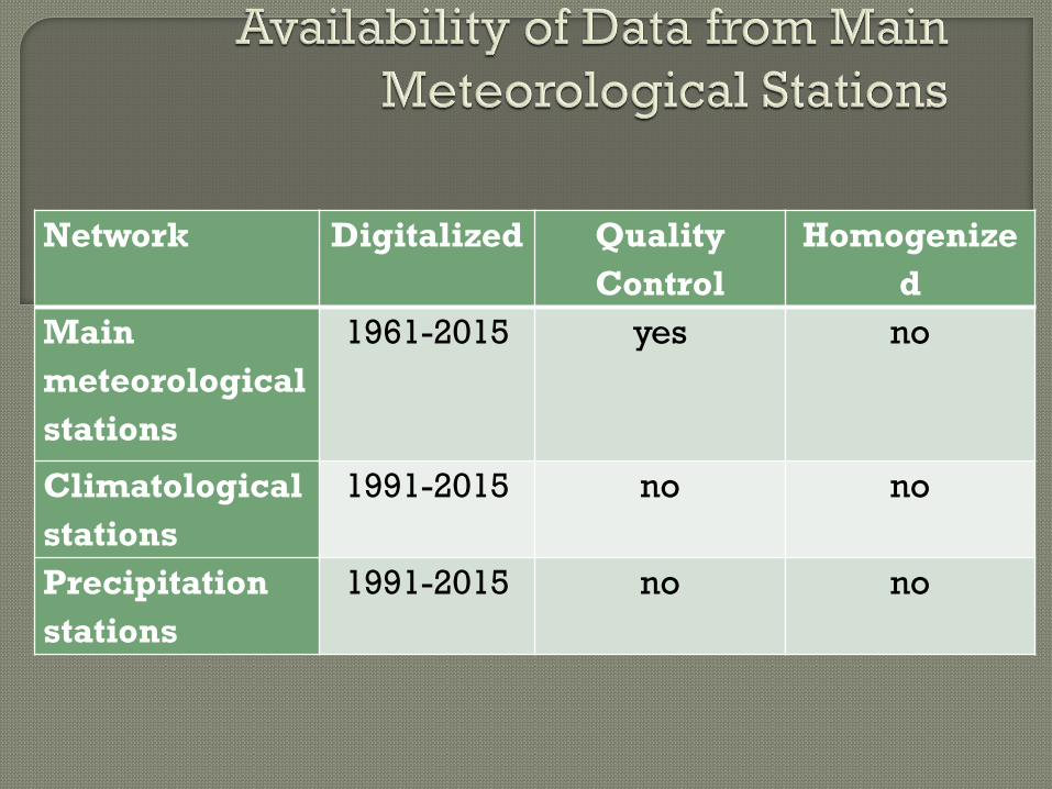
Network Digitalized Quality
Control
Homogenize
d
Main
meteorological
stations
1961-2015 yes no
Climatological
stations
1991-2015 no no
Precipitation
stations
1991-2015 no no

NetworkData
Period 1961-
1990
Period 1971-
2000
Period 1981-
2010
Main
meteorological
stations
Monthly
Temperature
(mean, max and
min),
precipitation
Available
Temperature
(mean, max and
min),
precipitation
Available
On request*
Daily On request* On request* On request*
Climatological
stations
Monthly On request* On request* On request*
Daily On request* On request* On request*
Precipitation
stations
Monthly On request* On request* On request*
Daily On request* On request* On request*

Data Cost (without VAT)
Denari
Cost (without VAT)
app.euro
Daily data for one meteorological
element from one meteorological
station for one year
3040 50
Monthly data for one meteorological
element or parameter from one
meteorological station for series of
30 years
2560 42
Monthly data for one meteorological
element or parameter from one
meteorological station for more than
30 years
3680 60
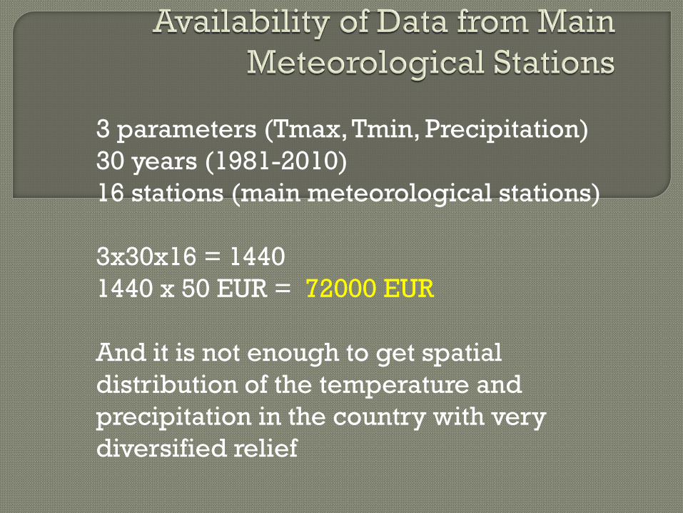
3 parameters (Tmax, Tmin, Precipitation)
30 years (1981-2010)
16 stations (main meteorological stations)
3x30x16 = 1440
1440 x 50 EUR = 72000 EUR
And it is not enough to get spatial
distribution of the temperature and
precipitation in the country with very
diversified relief

Annual January
July

Warm part of
the year
Cold Part of the
year
The national policy for the areas with natural constrains is
defined by the article 76 and 77 of the Law on Agriculture
and Rural Development (Official Gazette of Republic of
Macedonia No 49/10 from 12.04.2010).
The article 76 state that the policy for encouraging the
agricultural activity useful for environment is
implemented through sets of measures, and one of them
is:
Sustainable use of agricultural land through measures to
support agricultural activity in areas with limited
opportunities.

Moreover the article 77:
Assistance for agricultural activity in areas with
limited opportunities for agricultural production is
granted to agricultural holdings that operate in such
areas in the form of direct payments for support of the
income on farms.
The direct payments are paid to agricultural holdings
in the form of annual payments by unit area of the
cultivated agricultural land and can not be more than
30000 MKD (approx. 500 EUR) per hectare

The type of the activities supported by this measures
should be prescribed by the Minister and
implementation procedure should be defined by the
director of the Agency after the positive opinion of the
Ministry of Agriculture, Forestry and Water Economy.
This article allows exception of additional payment of
15% of the direct payments for areas with natural
constrains.

• The programme for the direct support of the rural
development for year 2016 (Official gazette No.
6/2016 from 15.01.2016 predicted measure 211 -
Assistance for agricultural activity in areas with
limited opportunities for agricultural production
• It is conducted according paragraph 8 of the
article 77 - as additional financial support
amounting to 15% of direct payments per unit
area or livestock unit for agricultural holdings in
the areas with limited production.
• The amount of the financial support for this
measure in year 2016 is 35 million MKD (5 million
for the year 2016 and 30 million for not realized
payments in previous years).

The areas that are eligible for getting this support
(Assistance for agricultural activity in areas with limited
opportunities for agricultural production) are defined in
the Decree on the criteria for direct payments, the
beneficiaries, the maximum amount and the method for
direct payments for 2016 ) Official Gazette 2/2016 from
8.1.2016)
According this act eligible for additional payment of 15
% are areas elevated above 700 m above sea level.
The criteria for defining areas with natural constrains
can much better access the real constrains and it is very
good to have defined and proclaimed areas with natural
constrains and defined measures for various constrains.
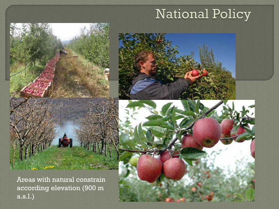
Areas with natural constrain
according elevation (900 m
a.s.l.)
