analytical queries on road networks: an experimental evaluation
TRANSCRIPT

Proceedings of the 23nd ACM SIGSPATIAL International Conference on Advances in Geographic Information Systems, M. Ali, M. Gertz,Y. Huang, M. Renz, and J. Sankaranarayanan, eds., Seattle, WA, November 2015.
Analytical Queries on Road Networks: An ExperimentalEvaluation of Two System Architectures ∗
Shangfu Peng Hanan Samet
Center for Automation ResearchInstitute for Advanced Computer Studies
Department of Computer ScienceUniversity of Maryland
College Park, MD 20742 USA{shangfu, hjs}@cs.umd.edu
ABSTRACTSpatial analytical queries on road networks typically perform hun-dreds of thousands to several millions of shortest distance computa-tions in the process of producing results. These queries require ar-chitectures that can compute a large number of network distances.Two architectures are evaluated on a variety of spatial analyticalqueries on road networks. The first architecture is a widely usedhybrid architecture that uses a database to store spatial datasets, aroad network distance computing module, and an analysis tool totie them together into a single query processing pipeline. The sec-ond architecture uses of a distance oracle representation of a roadnetwork. This architecture stores the spatial datasets and the dis-tance oracle inside the database, and the query processing is com-pletely handled by the database. A detailed evaluation of the twoarchitectures for a variety of analytical query processing tasks suchas region, KNN, distance matrix and trajectory queries is presentedand the lessons learned are discussed.
Categories and Subject DescriptorsH.2.8 [Database Management]: Database Applications—Spatialdatabases and GIS; H.2.4 [Database Management]: Systems—Query processing
Keywordsspatial analytical query, distance oracle, road network, system ar-chitecture
1. INTRODUCTIONThe past two decades has seen a steady increase in processing
spatial queries. Such functionality has been implemented in earlysystems such as QUILT [34, 43] and SAND [22, 35] which hada browsing capability to full-fledged mapping applications such as
∗This work was supported in part by the NSF under Grants IIS-10-18475, IIS-12-19023, and IIS-13-20791.
Permission to make digital or hard copies of all or part of this work forpersonal or classroom use is granted without fee provided that copies are notmade or distributed for profit or commercial advantage and that copies bearthis notice and the full citation on the first page. Copyrights for componentsof this work owned by others than ACM must be honored. Abstracting withcredit is permitted. To copy otherwise, or republish, to post on servers or toredistribute to lists, requires prior specific permission and/or a fee. Requestpermissions from [email protected]’15, November 03-06, 2015, Bellevue, WA, USAc©2015 ACM ISBN 978-1-4503-3967-4/15/11...$15.00
DOI: http://dx.doi.org/10.1145/2820783.2820806.
MapQuest, Yahoo Maps, Google Maps, and Bing Maps. They allrequire the computation of the distance between two locations xand y which in our work is more accurately represented as the net-work distance DIST (x,y) instead of the Euclidean distance ||x−y||,or variants of it such as a minimum distance to a block bound-ary (e.g., [33, 40]) or the Hausdorff distance (e.g., [29]). Beyondsimple navigation queries, location-based web services like GoogleMaps repeatedly pose queries on a road network and utilize theresults to serve a user base. For example, Google Distance Ma-trix offers an API that computes the distance matrix between a setof origins and a set of destinations. Other examples include an-alysts who use OLAP stores to perform complex simulations onroad networks to help answer queries such as determining whereto locate an additional Walmart among a number of potential loca-tions, or the roads where bottlenecks exist for evacuation planningpurposes. Moreover, mobile services frequently interact with write-optimized stores to store the current positions of mobile hosts asthey move about in a road network. These services also frequentlycompute the distances from their mobile hosts to other mobile hostsor landmarks in order to provide services such as locating the knearest restaurants or gas stations. We use the term spatial analyti-cal queries to collectively describe such queries. The challenge liesin taking note of the realization that each such instance of a spatialanalytical query invariably involves being able to make hundredsto as many as millions of computations of distance along a spatialnetwork rather than as the crow flies.
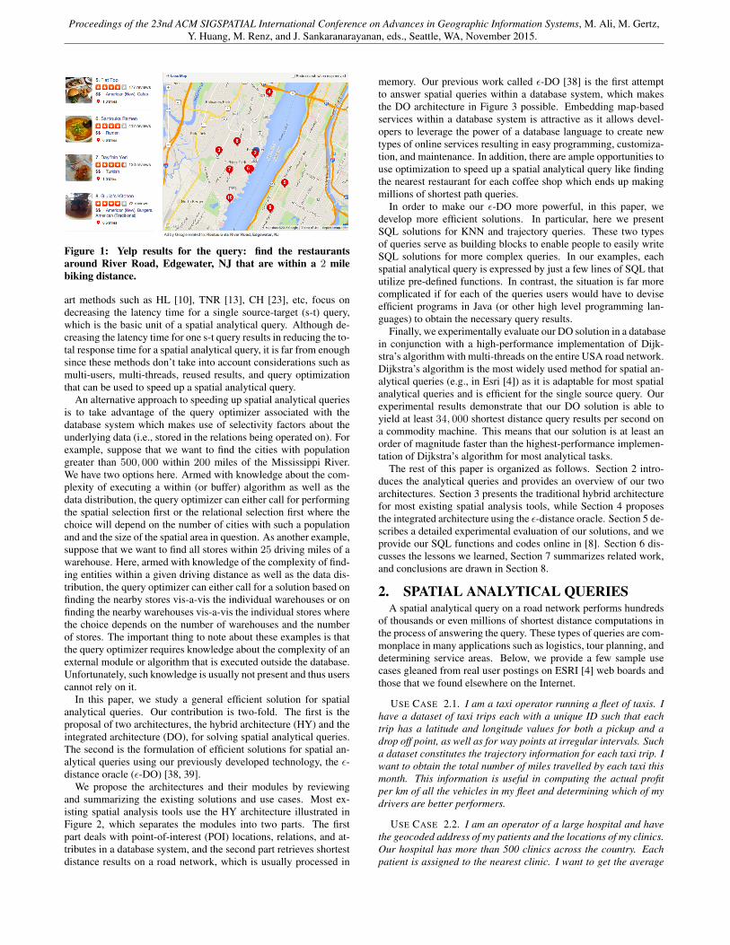
In the face of a massive amount of spatial analytical queries frominternet scale users, for example, Google Maps [6] drastically re-stricts the number of shortest distance results per query (e.g., a limitof 100 shortest distances per query using the Google Distance Ma-trix API). Most other existing services such as Yelp just use Eu-clidean distance instead of network distance. Figure 1 illustratesthe drawback of using Euclidean distance. It shows Yelp’s responseto the query: find the restaurants around River Road, Edgewater, NJ(blue icon) with the distance filter that they are within a 2 mile bik-ing distance. Obviously the 5th and 9th results that lie on the otherside of the river are impossible to reach by biking less than 2 miles.However, they are in the result set (e.g., Flat Top, the 5th result, is1.3 miles away using Euclidean distance).
Reviewing previous research work, we find none that are con-cerned with general spatial analytical queries. Instead, they fo-cus on speeding up one specific type of query, e.g., KNN searchqueries [16, 18, 29, 31], CNN queries [15], and distance matrix [25].However, these algorithms are not easy to extend to include generalspatial analytical queries. On the other hand, most state-of-the-
Proceedings of the 23nd ACM SIGSPATIAL International Conference on Advances in Geographic Information Systems, M. Ali, M. Gertz,Y. Huang, M. Renz, and J. Sankaranarayanan, eds., Seattle, WA, November 2015.
Figure 1: Yelp results for the query: find the restaurantsaround River Road, Edgewater, NJ that are within a 2 milebiking distance.
art methods such as HL [10], TNR [13], CH [23], etc, focus ondecreasing the latency time for a single source-target (s-t) query,which is the basic unit of a spatial analytical query. Although de-creasing the latency time for one s-t query results in reducing the to-tal response time for a spatial analytical query, it is far from enoughsince these methods don’t take into account considerations such asmulti-users, multi-threads, reused results, and query optimizationthat can be used to speed up a spatial analytical query.
An alternative approach to speeding up spatial analytical queriesis to take advantage of the query optimizer associated with thedatabase system which makes use of selectivity factors about theunderlying data (i.e., stored in the relations being operated on). Forexample, suppose that we want to find the cities with populationgreater than 500, 000 within 200 miles of the Mississippi River.We have two options here. Armed with knowledge about the com-plexity of executing a within (or buffer) algorithm as well as thedata distribution, the query optimizer can either call for performingthe spatial selection first or the relational selection first where thechoice will depend on the number of cities with such a populationand and the size of the spatial area in question. As another example,suppose that we want to find all stores within 25 driving miles of awarehouse. Here, armed with knowledge of the complexity of find-ing entities within a given driving distance as well as the data dis-tribution, the query optimizer can either call for a solution based onfinding the nearby stores vis-a-vis the individual warehouses or onfinding the nearby warehouses vis-a-vis the individual stores wherethe choice depends on the number of warehouses and the numberof stores. The important thing to note about these examples is thatthe query optimizer requires knowledge about the complexity of anexternal module or algorithm that is executed outside the database.Unfortunately, such knowledge is usually not present and thus userscannot rely on it.
In this paper, we study a general efficient solution for spatialanalytical queries. Our contribution is two-fold. The first is theproposal of two architectures, the hybrid architecture (HY) and theintegrated architecture (DO), for solving spatial analytical queries.The second is the formulation of efficient solutions for spatial an-alytical queries using our previously developed technology, the ε-distance oracle (ε-DO) [38, 39].
We propose the architectures and their modules by reviewingand summarizing the existing solutions and use cases. Most ex-isting spatial analysis tools use the HY architecture illustrated inFigure 2, which separates the modules into two parts. The firstpart deals with point-of-interest (POI) locations, relations, and at-tributes in a database system, and the second part retrieves shortestdistance results on a road network, which is usually processed in
memory. Our previous work called ε-DO [38] is the first attemptto answer spatial queries within a database system, which makesthe DO architecture in Figure 3 possible. Embedding map-basedservices within a database system is attractive as it allows devel-opers to leverage the power of a database language to create newtypes of online services resulting in easy programming, customiza-tion, and maintenance. In addition, there are ample opportunities touse optimization to speed up a spatial analytical query like findingthe nearest restaurant for each coffee shop which ends up makingmillions of shortest path queries.
In order to make our ε-DO more powerful, in this paper, wedevelop more efficient solutions. In particular, here we presentSQL solutions for KNN and trajectory queries. These two typesof queries serve as building blocks to enable people to easily writeSQL solutions for more complex queries. In our examples, eachspatial analytical query is expressed by just a few lines of SQL thatutilize pre-defined functions. In contrast, the situation is far morecomplicated if for each of the queries users would have to deviseefficient programs in Java (or other high level programming lan-guages) to obtain the necessary query results.
Finally, we experimentally evaluate our DO solution in a databasein conjunction with a high-performance implementation of Dijk-stra’s algorithm with multi-threads on the entire USA road network.Dijkstra’s algorithm is the most widely used method for spatial an-alytical queries (e.g., in Esri [4]) as it is adaptable for most spatialanalytical queries and is efficient for the single source query. Ourexperimental results demonstrate that our DO solution is able toyield at least 34, 000 shortest distance query results per second ona commodity machine. This means that our solution is at least anorder of magnitude faster than the highest-performance implemen-tation of Dijkstra’s algorithm for most analytical tasks.
The rest of this paper is organized as follows. Section 2 intro-duces the analytical queries and provides an overview of our twoarchitectures. Section 3 presents the traditional hybrid architecturefor most existing spatial analysis tools, while Section 4 proposesthe integrated architecture using the ε-distance oracle. Section 5 de-scribes a detailed experimental evaluation of our solutions, and weprovide our SQL functions and codes online in [8]. Section 6 dis-cusses the lessons we learned, Section 7 summarizes related work,and conclusions are drawn in Section 8.
2. SPATIAL ANALYTICAL QUERIESA spatial analytical query on a road network performs hundreds
of thousands or even millions of shortest distance computations inthe process of answering the query. These types of queries are com-monplace in many applications such as logistics, tour planning, anddetermining service areas. Below, we provide a few sample usecases gleaned from real user postings on ESRI [4] web boards andthose that we found elsewhere on the Internet.
USE CASE 2.1. I am a taxi operator running a fleet of taxis. Ihave a dataset of taxi trips each with a unique ID such that eachtrip has a latitude and longitude values for both a pickup and adrop off point, as well as for way points at irregular intervals. Sucha dataset constitutes the trajectory information for each taxi trip. Iwant to obtain the total number of miles travelled by each taxi thismonth. This information is useful in computing the actual profitper km of all the vehicles in my fleet and determining which of mydrivers are better performers.
USE CASE 2.2. I am an operator of a large hospital and havethe geocoded address of my patients and the locations of my clinics.Our hospital has more than 500 clinics across the country. Eachpatient is assigned to the nearest clinic. I want to get the average

Proceedings of the 23nd ACM SIGSPATIAL International Conference on Advances in Geographic Information Systems, M. Ali, M. Gertz,Y. Huang, M. Renz, and J. Sankaranarayanan, eds., Seattle, WA, November 2015.
drive time for patients per clinic. This is an important metric inhealthcare since the further one has to drive, the poorer are thehealth outcomes. This distance also informs us of the need to opennew clinics or relocate existing ones to better serve our patients.
USE CASE 2.3. I have a trucking company with 10 trucks thatdeliver thousands of packages for a popular retailer. A commonoperation that I run several times during each day is determiningwhich packages should be loaded on to which truck and the orderin which they should be delivered. This decision process constitutesa complex tour planning query that tries to minimize the total net-work distance travelled by all trucks, as well as to accommodatethe priority assigned to each package. For this purpose, the inputis a network distance matrix between the delivery locations of allcurrent packages. An optimization program would decide how toassign packages to trucks and the order in which to deliver them.Note that even with 1000 packages, the query will compute up to 1million pair-wise network distances.
For spatial analytical queries on road networks, there are twocommon reasons why such queries end up making a very largenumber of distance computations. First, spatial analytical queriesare typically used for generating insights into the data in the form ofreports or visual representations. So it is common for these queriesto end up accessing large portions of the data. Second, the queriesmay join two or more datasets on the basis of the network distanceto other objects on the road network, such as finding the nearestneighbors from one dataset for each location in another dataset, orgroup one or more datasets based on the closest distance to objectsin another dataset. Executing all of these operations can easily endup making millions of distance computations on the road network.For instance, just the simple query that obtains the network dis-tance between all pairs of objects drawn from a set of 1000 objectsto one another ends up making 1 million distance computations onthe road network.
Since the spatial analytical queries are an important use-casewhose efficiency depends on being able to compute millions of net-work distance computations efficiently on road networks, there isa need to examine which of existing available architectures are ca-pable of efficiently processing these queries. Most existing toolsfor spatial analytical queries have several limitations, or use thebasic Dijkstra’s algorithm. For example, the Google Distance Ma-trix API [6] limits non-paying users to submit 100 shortest dis-tances (10 origins and 10 destinations) per query, and obtain 2, 500shortest distances per 24 hour period. For paying customers, thelimits are 625 shortest distances per query, and 100, 000 shortestdistances per 24 hour period. Esri [4] also claims that the ArcGISNetwork Analyst extension, namely the Route, Closest Facility, andOD Cost Matrix solvers, are based on the well-known Dijkstra’salgorithm for finding shortest paths. All these tools are not goodenough to solve spatial analytical queries.
Spatial analytical queries make two distinct kinds of access pat-terns on road networks, and make millions of these accesses in theprocess of answering a query. The most basic pattern is called one-to-one pattern which computes the distance between a source anda destination on the road network. Another access pattern is one-to-many that makes several s-t pair computations from the samesource vertex. For instance, computing the K nearest neighborsfor each point from a large dataset makes one-to-many access pat-terns. There are opportunities for speeding up one-to-many patternseven though they are nothing more than multiple one-to-one accesspatterns. We use the term scan to describe the actual implementa-tion of the execution of an access pattern. Note that there can bemany options for executing a scan including Dijkstra’s algorithm,
SQL
SCANSOne-to-Many
One-to-One
ROAD NETWORK SCANNER
ANALYSIS TOOL
APPLICATIONS
DATABASE
Datasets
SCANS
Optimizer
Figure 2: The HY architecture, which represents most existingspatial analysis tools
contraction hierarchies (CH) [23], etc.Any architecture for answering spatial analytical queries must be
optimized for performing a large number of distance queries on theroad network. In particular, we present two such architectures andthen compare and contrast their features.
The first architecture is a hybrid architecture that uses a databaseto store and query spatial datasets, but then uses an external mod-ule that loads the road network in the main memory and performsfast in-memory scans on the road network. This approach takes ad-vantage of the large amount of available memory in modern com-puters as well as the high number of processing cores to be ableto compute a large number of scans quickly. An analysis tool co-ordinates the data transfer and the issuance of scans to the roadnetworks. A common example of such an approach is the processused by the ArcGIS Network Analyst to solve problems such asUse Case 2.2. The information pertaining to both clinics and pa-tients is maintained in a database system. In order to compute theaverage driver distance for each clinic, the ArcGIS Network Ana-lyst first retrieves the related data from the database, and then scansthe network starting at the clinic using Dijkstra’s algorithm whichhere is implementing a one-to-many access pattern. The scan pro-cess stops when it has obtained all the network distances of theclinic’s patients.
The second architecture incorporates the road network inside thedatabase as a single relation. The road network is stored as a dis-tance oracle [38] relational table indexed by a B-tree. Scans on theroad network become lookups on the B-tree index which is veryefficient to perform. This method relies on being able to performthe queries entirely inside a database and on using the declarativenature of an RDBMS to automatically optimize queries.
3. HYBRID ARCHITECTUREThe most common architecture for responding to spatial queries
on a road network is a hybrid (denoted by HY) one consisting ofa database to store the spatial datasets and a module external tothe database to execute the actual operations on the road network.Figure 2 shows such a representative architecture that combines adatabase, an analysis tool, and an external module for network pro-cessing. An example of a system that deploys such an architectureis ArcGIS from Esri [4], a popular platform for performing deepanalysis to make informed decisions. The analysis tool is at theheart of this architecture in the sense that it extracts the necessarydata from the database, pre-processes it, and contacts the road net-work scanner to perform the necessary scans on the road network.

Proceedings of the 23nd ACM SIGSPATIAL International Conference on Advances in Geographic Information Systems, M. Ali, M. Gertz,Y. Huang, M. Renz, and J. Sankaranarayanan, eds., Seattle, WA, November 2015.
In this architecture, the analysis tool partitions the query process-ing into two parts. The first part queries the database to accessthe spatial datasets, such as restaurants, gas stations, real estate in-formation, warehouses, etc. When the volume of datasets is large(which is the usual case), this database is usually a conventional off-the-shelf database; if their volume is small, then they may even beloaded into main-memory from files (e.g., shapefiles) in which casewe have a main-memory database. The second part uses the anal-ysis tool’s road network module to compute network distances be-tween the objects. Actually, the network distance computations areincorporated into the processing and the result is either displayed tothe user or stored back into the database. In this model, the networkprocessing happens entirely outside the database while the analysistool serves as the “glue” that coordinates computations between thedatabase and the road network module.
The road network scanner is an in-memory processing modulethat implements the execution of the access patterns on large roadnetworks. It contains at least one spatial index such as a k-d tree orR-tree to locate the given locations, and one or more priority queuesto speed up the scan process. In order to fully utilize the computingpower of multi-cores, this module also needs to employ several pro-cessing threads. Each thread responds to one scan process at a time.Its not worth to parallelize the workload inside one scan process us-ing several threads as previous work [17, 28] has shown that paral-lelization of Dijkstra’s algorithm and similar scan-based algorithmswith traditional locks and barriers has disappointing performance.In particular, our implementation of HY built a k-d tree in the mainthread which was pre-loaded with the vertices of the graph. Themain thread uses the k-d tree to locate the source point of a givenscan task, while the destination points of the scan task are obtainedfrom the POI table. Next, our implementation sets up several scan-ning threads to process Dijkstra’s algorithm (we could have alsoused another method like CH) to obtain distance results. All scan-ning threads share the graph representation, and each thread keepsa private scanned queue to store the visited vertices and a heap (aswe are using Dijkstra’s algorithm) to determine the next vertex toscan. Each time that the main thread is presented with a scan task,the main thread first locates the source point using the k-d tree, andthen assigns the scan task with its associated source and destinationpoints to a waiting scan thread. All threads use busy-waiting.
In addition, between the analysis tool and the road network scan-ner, an optimizer module would be useful to automatically optimizethe scan plan. However, often, users dispense with this step as mostexisting analysis tools rely on the user’s specification of the scanplan. At the end of Section 4, we give an example to see the impor-tance of having an optimizer.
The road network scanner in Figure 2 shows two access patternsfor retrieving shortest distances. The one-to-one access pattern isthe commonest, although the one-to-many access pattern is alsocommonly used as it is optimized for multi-destinations. Note thatideally there should also be a third access pattern of the form many-to-many. However, very few access pattern implementation algo-rithms are designed for a many-to-many access pattern because itseffect can be obtained by resorting to multiple instantiations of theone-to-one and one-to-many access patterns as in [25].
Each specific algorithm that retrieves the shortest distances andpaths implements one of the two access patterns. For example,Dijkstra’s algorithm is good for the one-to-many access pattern,while CH [23] is good for the one-to-one access pattern. The roadrepresentation of a specific algorithm is the lowest component inFigure 2, e.g., Dijkstra’s algorithm uses the original graph repre-sentation and TNR [13] uses the hierarchical tree representation.
Below we provide an abstraction of the operation of the scan
procedures instead of the details of the algorithms that implementthem. In particular, our HY architecture given in Figure 2 imple-ments the following operators on road networks:
DEFINITION 3.1. The SCAN() operator scans the road networkin memory using one of the scan-based algorithms,A. GivenG(A),the graph representation of A, and vertex s, SCAN(s) uses A toscan G(A) starting at s.
We now define two operators that are frequently used in the spa-tial analytical queries, SCAN_UNTIL_K() and SCAN_UNTIL_DIST().They inherit the SCAN() operator.
DEFINITION 3.2. SCAN_UNTIL_K(k, s, P ) scans the graphstarting at vertex s, and returns the k nearest objects o to s, whereo ∈ P and P is the POI set.
DEFINITION 3.3. SCAN_UNTIL_DIST(d, s, P ) scans the graphregion within network distance d from vertex s, and returns all theobjects o, where o ∈ P and P is the POI set, and o is within net-work distance d from s.
SCAN_UNTIL_K() stops the scanning when it has visited k ob-jects inP , and SCAN_UNTIL_DIST() limits the scanning to objectslying within a specified network distance. The set of P indicatesthe set of POIs, which is an overlay over the network graph. It canbe a set of restaurants, gas stations, houses, as well as even all thevertices of the road network. As far as we know, every spatial an-alytical query contains at least one set of POIs. After defining theSCAN() operators, we can easily describe the processes of spatialanalytical queries using a scan-based algorithm. For example, aKNN query can be solved by the SCAN_UNTIL_K(k, s, P ) oper-ator, and a distance matrix query, which has n sources and m des-tinations, can be solved by making n calls to SCAN_UNTIL_K(m,si, P ) where si is the ith source.
4. INTEGRATED ARCHITECTUREThe database community desires an integrated architecture, which
means that all components and procedures reside in a database.This makes the architecture more compact and efficient, as the an-alytical query executes entirely within the database. The databaseknows how to optimize such queries, since the road representationappears as one or several relations in the database, and thus thequery appears like any other relational query to the database. Thecore challenge lies in how to embed the road representation in thedatabase. For example, pgRouting [7] extends the PostGIS / Post-greSQL geospatial database to provide geospatial routing function-ality. Oracle Corporation proposed the Network Data Model Graph(NDM) [30], which persistently manages the network connectivityin the database, while a Java API provides fast in-memory graph an-alytics. However, since the road representation in both pgRoutingand NDM is the original graph representation, they are similar tothe HY architecture except for storing the nodes and edges in theirdatabase. HLDB [11] proposed by Microsoft Research is the firstpractical system that can answer spatial queries on continental roadnetworks stored entirely within a database. It stores the vertices ofthe road network, as well as sets of “forward” and “backward” hublabels (HL) of the vertices [10] in the database. Each s− t query issolved by performing a JOIN on the corresponding “forward” and“backward” relational tables of s and t, respectively.
In this section, we propose the integrated architecture that makesuse of our previously developed technology, the ε-DO [38]. Thedistance oracle [38] takes a road network as input, and reduces itto a single database relation that captures the network distances be-tween every pair of vertices in the road network. The technique is

Proceedings of the 23nd ACM SIGSPATIAL International Conference on Advances in Geographic Information Systems, M. Ali, M. Gertz,Y. Huang, M. Renz, and J. Sankaranarayanan, eds., Seattle, WA, November 2015.
based on the notion of spatial coherence, which can be describedintuitively using the following example. The network distance be-tween any vertex (more generally any location denoted by its lati-tude and longitude) in the Washington, DC region to any vertex inthe Boston, MA region can be reasonably approximated by a sin-gle distance value. This is because the shortest path regardless ofwhere one starts in the DC region or wants to go in the Boston re-gion ends up using I-95N. This large overlap in the shortest pathsmeans that the network distance between sources in Washington,DC and destinations in Boston, MA can be approximated by a sin-gle value with a bounded approximation or error tolerance. Fur-thermore, as the sources and destinations get farther apart, one canapproximate even larger regions of sources and destinations with asingle value. For instance, Maryland and California can be approx-imated by a single value with a bound on the approximation errorsince the sources and destinations are quite far from one another.
Using a cluster of 50 EC2 machines, it took us about 6 hoursto compute the distance oracle of the USA road network whichcontained 24 million vertices. The precomputation process decom-posed the road network with n vertices intoO( n
ε2) triples (A,B, d)
stored in a relational table, such thatA andB are denoted by blocksin a PR quadtree and d is the network distance that approximatesthe network distance between every pair of vertices contained in Aand B within an ε error tolerance. In particular, d is also said tobe ε-approximate, which means that the resulting error in using dinstead of the exact network distance between the any vertex in Aand any vertex inB is bounded by the ε error tolerance. The result-ing representation for the entire USA was about 55GB in size withan error tolerance ε = 0.25. This is a reasonable setting for realroad networks. In particular, in our previous work [38], we showedthat although the error tolerance ε is 0.25, the approximate distancevalue of at least 20% of the vertex pairs has an error of less than1%. Moreover, the average error for random queries is just 2.74%.The relational table corresponding to the distance oracle is indexedby a B-tree representation that allows disk efficient loopkups forapproximate distances.
Using the distance oracle, we created an integrated architectureillustrated in Figure 3. The key difference from the hybrid archi-tecture is the use of the distance oracle road representation, whichhas been embedded in a database as a simple relational table. Toquery the distance oracle, we implemented an SQL function calledDIST(), which queries the distance oracle relational table to com-pute the road distance between any source and destination. In par-ticular, given two latitude/longitude pairs, DIST() first computes aunique code which it looks up in the distance oracle relational table,and then uses a simple SELECT query that is facilitated by the B-tree index. For example, computing the network distance betweenthe White House and the US Capitol Building in Washington, DCbecomes as simple as the following query that
-- Road distance between White House and US CapitolSELECT DIST(38.8977, -77.0366, 38.8898, -77.0091);-- This produces 2144.7 (meters)
More user-defined functions (UDFs) and complex queries canalso be easily expressed using the distance oracle. Let us considerthe following example. Suppose that we have a relation houses(id, lat, lon) corresponding to the location of all housesavailable for sale and another relation parks(id, lat, lon)corresponding to the location of all parks, where lat and lon cor-respond to the latitude and longitude values of the correspondinglocations. We want to find up to 100 houses with the maximumnumber of parks that lie within 0.5 km of road distance from thehouses sorted by the number of such parks. The following codewritten completely in SQL yields an efficient response to this query.
Logical Layer
Query Optimization
Physical Layer
Query Language Parsing
DISTANCE ORACLE
SQL
DIST()
DATASETS
Relational Operators
GIST INDICES
APPLICATIONS
Lookups One-to-Many One-to-One
UDFs
Figure 3: Integrated architecture DO for analytical queries us-ing the distance oracle.
SELECT id, count(*) as countFROM ( SELECT houses.id as id,
DIST(houses.lat, houses.lon,parks.lat, parks.lon) as distance
FROM houses, parks) as foo
WHERE distance < 500 -- 0.5 km in metersGROUP BY idORDER BY count DESCLIMIT 100;
Here we see how to express a complex query with just a fewlines of SQL. Now contrast this with performing the same query inthe traditional setup which uses a module where the road networkwould be stored externally as in Figure 2. The road network wouldtypically be accessible through an API such as SCAN_UNTIL_K()and SCAN_UNTIL_DIST() for computing shortest paths and dis-tances. In this setup, the hybrid architecture would first obtain atable of houses and parks from the database. Next, we have two op-tions to obtain the distance results using the SCAN_UNTIL_DIST().The first is for each house, to compute the number of parks within0.5 km. The second is for each park, to compute the houses within0.5 km, and then to group the distance results by the house ids. Fi-nally, for each house, count the number of parks and order them indescending order of the count.
Although the first option is straightforward for this query, It turnsout that the second option is more efficient as the number of parksis considerably smaller than the number of houses, which meansthe number of scans is lower. This example demonstrates that weneed an optimizer for the hybrid architecture to decide the order ofexecution and make the query execution plan. This depends on be-ing able to do selectivity factor estimation. On the other hand, theintegrated architecture has the bonus of having a query optimizer aspart of it although we did not need it in this example. In summary,the effort to implement a spatial analytical query as the above ex-ample in the hybrid architecture is considerably more complex thanwriting a few lines of SQL as in the integrated architecture.
5. EXPERIMENTSIn this section, we present a detailed evaluation of the two archi-
tectures in order to compare and contrast their query performance.Section 5.1 describes the experimental setup and datasets. Sec-tions 5.2 and 5.3 evaluate the performance of both HY and DO for

Proceedings of the 23nd ACM SIGSPATIAL International Conference on Advances in Geographic Information Systems, M. Ali, M. Gertz,Y. Huang, M. Renz, and J. Sankaranarayanan, eds., Seattle, WA, November 2015.
the region and throughput queries, respectively. We synthetize thequeries in these two subsections from the POI tables that we used.Next, Sections 5.4 and 5.5 show our solutions for the KNN andtrajectory queries, respectively, in realistic settings.
5.1 Experimental Setup and DatasetsThe integrated architecture (DO) is completely self contained in
a PostgreSQL database system, where analytical queries can be ex-pressed in SQL. It exposes a single function DIST(lat1, lon1, lat2,lon2) that will return the ε-approximate network distance betweena source and a destination location. The distance oracle for thewhole USA was used for this experiment with ε = 0.25 and is55GB in size. Although this number seems large, the fact that theroad network has close to 24 million vertices shows that this num-ber is consistent with our predicted linear storage bound of O( n
ε2)
space where n is the number of vertices in the road network.The hybrid architecture (HY) uses an entirely in-memory imple-
mentation that compactly stores the spatial datasets, the USA roadnetwork, and the road network scanner. The road network scannerimplements an efficient multi-thread implementation of Dijkstra’salgorithm and it defines the SCAN() functions, SCAN_UNTIL_K()and SCAN_UNTIL_DIST().
We rented one Amazon RDS db.m3.2xlarge DB instance withPostgreSQL 9.3.5 for the DO architecture. For the HY architecture,we rented one Amazon EC2 m3.2xlarge. Both of these machineshave identical hardware specs (8 vCPU and 30 GB memory) andwere used in their default settings. The USA road network wasfrom the 9th DIMACS Implementation Challenge [2], which con-tained 23, 947, 347 vertices and 58, 333, 344 edges.
We used two POI tables for the evaluation. The restaurant tableconsists of 49, 573 fast food restaurants obtained from [9], and theuniversity table consists of 5, 964 locations of universities from [5].The schemas of both tables are identical and are (id, latitude, lon-gitude, gid, geom), where gid and geom are needed for the GiSTindex on the latitude/longitude values.
We also used a taxi trajectory dataset. This taxi dataset was fromSan Francisco Yellow Cab [1] collected by CRAWDAD [3]. It con-tained 11, 220, 058 GPS entries for 537 taxis covering a one monthperiod in 2008 comprising 928, 307 trips. The schema for the taxitrajectory relation is given in Table 1.Table 1: Schema for table taxi storing the taxi GPS information.
Attribute Explanationid crumb id (unique key, we added)taxiid each taxi has a unique idtripid globally unique trip id (we added)lat latitude in degreeslon longitude in degreesoccupancy does cab have a fare? (1 = occupied, 0 = free)ts UNIX epoch time when GPS was recorded
An example tuple is as follows: [id, taxiid, tripid, lat, lon, oc-cupancy, time], e.g.: [112133, 1, 422, 37.75134, -122.39488, 0,1213084687]. Each taxi periodically records a GPS record on theserver. We assume that each taxi takes the shortest path betweensuccessive GPS crumbs. Therefore, reconstructing the trip involvesordering the points by their timestamp (ts) (or equivalently by theirid since we assigned the ids in order of increasing timestamp),thereby obtaining the road network distance between successivepoints and adding up the distance values.
5.2 Region QueryA distance query returns the destinations lying within a given
network distance of X kilometers around a given location denoted
100
101
102
103
104
5 10 20 50 100 200 500
Tim
e (s
econ
ds)
Distance (km)
HY-1HY-7
DO
100
101
102
103
104
105
5 10 20 50 100 200 500
Tim
e (s
econ
ds)
Distance (km)
HY-1HY-7
DO
(a) (b)
Figure 4: Time comparison between HY and DO varying withthe furthest distance values for (a) restaurant is destination,and (b) university is destination
by its latitude and longitude values. The example query we use forevaluation here is one that for each university, finds all restaurantslying within X kilometers.
To solve this query, HY invokes the SCAN_UNTIL_DIST() oper-ator that for each of the universities, scans the graph until obtainingall vertices withinX kilometers from the university. This operationis very efficient and limits the scans to one per university.
In the DO architecture we don’t want to compute the distance be-tween all pairs of universities and restaurants. Therefore, we needa simple way of reducing the number of invocations to the distanceoracle. One way to do this is to take advantage of the fact thatthe Euclidean distance is a lower bound on the road network dis-tance and thus we restrict the pairs of objects that we examine to bewithin their Euclidean distance. This is achieved by using a querysearch window of width 2X around each university and only exam-ining the restaurants lying in it. This translates to a query windowof width 2X/111 degrees assuming that 1 degree of latitude/longi-tude roughly equates to a geodesic distance of 111 kms. The SQLstatement for this query is as follows.
SELECT * FROM(SELECT x.id as id1, y.id,
dist(x.lat, x.lon, y.lat, y.lon) as dFROM University x, Restaurant yWHERE y.lat between x.lat-deg AND x.lat+degAND y.lon between x.lon-deg AND x.lon+deg
ORDER BY dist) as foo
WHERE d<XGROUP BY id1
Figure 4 shows the execution time of DO and HY when varyingthe width of the query region. For HY, we show the performanceof running 1 and 7 scanning threads using HY-1 and HY-7 respec-tively. The reasons for using 7 scanning threads are explained inAppendix A. Figure 4(a) shows the results of region queries thatfind the restaurants within X kilometers of each university, whileFigure 4(b) interchanges the sets that form the sources and destina-tions so that now we find the universities within X kilometers ofeach restaurant.
This experiment is to HY’s advantage in the sense that it canamortize the costs of the scans from a single source to multiple des-tinations. Nevertheless, Figure 4(a) shows that for smaller valuesof the distance X , HY is slightly better than DO but this advantagevanishes as X increases with DO performing better than HY forX > 100. The setting of Figure 4(a) where we find the restaurantsnear the universities represents the worst case for DO as we expectmany restaurants to be clustered around each university compellingDO to query the distance oracle once for each pair. On the otherhand, when we change the setting so that we find the universitiesnear the restaurants as in Figure 4(b), we find that the executiontime of HY is at least one order of magnitude greater than DO

Proceedings of the 23nd ACM SIGSPATIAL International Conference on Advances in Geographic Information Systems, M. Ali, M. Gertz,Y. Huang, M. Renz, and J. Sankaranarayanan, eds., Seattle, WA, November 2015.
101
102
103
10-410-310-210-1
Tim
e (s
ec)
Density
HY-1HY-7
DO
Figure 5: Execution time versus a synthetically varying densityof destinations for 5, 964 distance queries (corresponding to thesize of the university sources relation at distance 50 km.
since there may not be too many universities around each of therestaurants thereby greatly reducing the number of queries to thedistance oracle. While this experiment shows that DO is sensitiveto the density of the destinations, in the worst case it still performsas well as HY, while easily outperforming it in other cases.
To further explore the effect of density on DO’s performance,we performed the following experiment. Define density to be theratio of the number of destinations found to the number of ver-tices of the road network visited by HY during its scan around eachsource point for a given region. In some sense, density controlsthe work efficiency of HY vis-a-vis DO in that the larger the den-sity, the greater is the benefit obtained by HY from amortizing thescans. Figure 5 shows the execution times of HY and DO whenperforming the region query that finds all synthetically generateddestinations within 50 km of all universities. We created destina-tions around each university by generating points with a probabilitydenoted by the density value. Figure 5 shows that the density doesindeed affect DO as we had expected but does not affect HY forthe region query. In particular, as the density decreases (i.e., thepoints become sparse), DO improves dramatically as the numberof invocations of the distance oracle is greatly reduced. Note thatalthough DO is slower when the density is larger than 0.01, it isfairly obvious that for real world datasets, a density of more than 1restaurant per 100 vertices is extremely large to be realistic.
5.3 Throughput QueryTable 2: Comparison between s-t pair and one-to-many
Query Metric DO HY-7
Distance Matrix Time 8853.9 sec 20139 secThroughput 33392 dist/sec 14680 dist/sec
10k random pairs Time 0.327 sec 2026 secThroughput 30581 dist/sec 4.9 dist/sec
From the previous results we see that DO provides a single DIST()function that computes the road distance between any pair of sourceand destination locations on the road network. HY on the otherhand is optimized for one-to-many distance computations since thescan amortizes the work done for scanning from a single sourceto multiple destinations. To better understand the performance ofeach architecture we compare them using a distance matrix query.
In this query, we use the university dataset as the source locationsand the restaurant dataset as the destination locations. The querycomputes the distance matrix from all universities to all restaurants.The query can be executed by either performing 5, 964 one-to-many queries, or alternatively 5, 964× 49, 573 one-to-one queries.
While HY is optimized for the former access pattern, DO can onlyperform the latter access pattern. Regardless of how the distancesare computed, it takes 295.6 million distance computations on theroad network to compute this distance matrix. The following SQLstatement computes the distance matrix for DO.
SELECT x.id, y.id,dist(x.lat, x.lon, y.lat, y.lon) as dist
FROM University x, Restaurant y
Table 2 shows the performance of the DO and HY architectures.DO computes the distance matrix in 8853.9 seconds, while HYdoes it in 20139 seconds. The throughput for DO is 33.3k dis-tances/second while it is 14.6k distances/second for HY. Note thatthis is in spite of choosing a query workload that is favorable to HY.This shows that for a practical real query, DO is still 2.4× betterthan HY in terms of throughput.
The next question is how would HY perform if restricted to onlyuse the one-to-one access pattern. To provide this comparison, werandomly pick 10, 000 source university and destination restaurantpairs from the tables. While DO takes 0.327 seconds to computethe distances, HY takes 2026.4 seconds which amounts to just lessthan 5 distances/second, while DO can computer over 30, 000 dis-tances/second. This shows that HY is only appropriate if the queryresults can be obtained using a one-to-many access pattern as itsperformance for a one-to-one access pattern is prohibitively slow.
5.4 KNN QueryNext, we compare the performance of DO and HY for KNN
queries where the inputs are two datasets S and R, and the goalis to find the K nearest neighbors of each point in S from pointsdrawn from R. The workload for this subsection includes perform-ing 5, 964 KNN queries for each of the universities returning Knearest restaurants.
The HY architecture invokes SCAN_UNTIL_K(), which uses anin-memory graph representation and stores the 49, 573 restaurantsrelation in a k-d tree data structure. During processing, HY uses 7threads to scan the road network. Each thread starts scanning fromone of the university locations and for each vertex it performs alookup on the k-d tree to determine if there are any restaurants inits vicinity within a certain distance range. If yes, then they are en-queued with the appropriate network distance if they have not beenvisited before. This check is not necessary if while building thek-d tree, each restaurant is associated with its nearest vertex. Thisprocess is entirely in-memory and extremely efficient to perform.
The DO architecture computes DIST() between each universityand each restaurant in a candidate set of restaurants that have thepotential to be the K nearest neighbors. This candidate set is ob-tained by first using the GiST spatial index in Postgres to computetheK Euclidean nearest restaurants from the restaurant relation foreach university and then using DIST() to compute their correspond-ing network distances. Let d be the maximum of these networkdistances for the university being processed. Next, again use GiSTto compute all nearest restaurants for each university whose Eu-clidean distance is less than or equal to d and then use DIST() tocompute their corresponding network distances and retain the Kclosest ones.
This method is correct because the Euclidean distance is a lower-bound on the network distance. The lower bound property guaran-tees that we find the K network neighbors within the candidate set.The following SQL query captures the steps indicated above. In thesubquery kdn, we compute the Euclidean distance to the K neigh-bors using the GiST index and then compute the maximum networkdistance among K neighbors for each university.

Proceedings of the 23nd ACM SIGSPATIAL International Conference on Advances in Geographic Information Systems, M. Ali, M. Gertz,Y. Huang, M. Renz, and J. Sankaranarayanan, eds., Seattle, WA, November 2015.
101
102
103
104
105
50 500 5000 50000
Tim
e (s
econ
ds)
K
HY-1HY-7
DO
Figure 6: The execution time of 5, 964 KNN queries whereK =50, 500, 5000, and 49573.
SELECT kdn.id as id1, R.id as id2,dist(kdn.lat, kdn.lon, R.lat, R.lon)
FROM (SELECT y.id as id, y.lat as lat, y.lon as lon,
( SELECT max(dist)FROM (
SELECT dist(x.lat, x.lon, y.lat, y.lon)FROM restaurant xWHERE x.gid != y.gidORDER BY x.geom<->st_setsrid(y.geom, 4326)LIMIT K
) as foo) / 111000 as deg
FROM university y) AS kdn, restautant RWHERE R.lat between kdn.lat - kdn.deg
and kdn.lat + kdn.deg ANDR.lon between kdn.lon - kdn.deg
and kdn.lon + kdn.deg;
Figure 6 shows the execution time of the KNN queries for differ-ent values of K. We see that HY has nearly identical performancecompared to DO for smaller values of K less than 500. It becomes2− 3 times worse for larger values of K such as for K = 49, 573.At K = 49, 573, the query degenerates to compute the distancematrix between the source and destination tables.
Figure 7 illustrates the effect of the density on the execution timeof DO and HY for the KNN queries. In particular, each point in thefigure corresponds to the performance of one KNN query for ei-ther HY or DO. Here we use a real world dataset and thus for thevalues of K that we used, the density of most scans is less than0.01. Compared to the region query discussed in Section 5.2, theeffect of varying the density has a different effect on the executiontime of DO and HY. In particular, for the KNN query, the executiontime of HY increases significantly as the density decreases, whilethe execution time of DO does not change much. This is becausethe number of DIST() invocations for DO is proportional to K inreal world datasets. On the other hand, SCAN_UNTIL_K() for HYneeds to scan further to visit at least K destinations when the den-sity of the nearby destinations is sparser.
5.5 Trajectory QueryWe now examine a simple trajectory query implemented on both
the HY and DO architectures. The goal of the query is to com-pare performance on a real trajectory dataset consisting of GPSreadings. GPS devices are becoming commonplace and are nowdeployed on many different commercial and non-commercial ve-hicles. A company operating a fleet of taxis usually has a GPSinstalled in all of its vehicles, which enables an operator to knowthe locations of its vehicles. For instance, when a customer requests
101
102
103
10-410-310-210-1
Tim
e (m
s)
Density
HYDO
102
103
104
10-310-2
Tim
e (m
s)
Density
HYDO
(a) (b)
Figure 7: The execution time of the KNN query as a functionof the density for (a) K = 500 and (b) K = 5000.
a ride, the taxi operator uses the current locations of all of its vehi-cles to send the nearest vehicle to the customer. Of course, there aremore complex analyses that an operator may want to perform fromhistorical (i.e., a day/week/month/year) worth of GPS informationcollected from vehicles which can shed light on several aspects oftheir businesses.
For example, consider a query that seeks the execution time ofcomputing the total trip distance of each taxi. More SQL queriescan be found online in [8]. Executing it using DO involves a fewsimple steps as detailed below.
1. Extract all points of a given trajectory denoted by tripid
2. Create an ordering of the points
3. Compute road network distance between consecutive points
4. sum the distances to produce the trajectory distance
5. sum the trajectory distances to produce the taxi trip distance
On the other hand using HY to respond to this query involvessorting all GPS records according to the ts attribute in the initial-ization. Next, defining a segment as two consecutive GPS loca-tions on the same trip, we compute the distance of each segmentby assigning it to one scanning thread. Thus, one segment containsone source and one destination location. Intuitively, each segmentquery is better described as a one-to-one access pattern, so that DOshould be better than HY in this case. However, since the GPSsensors report their locations frequently, the distance between twoconsecutive GPS reports is very short, which benefits HY. Prior ex-periments for one-to-many access pattern queries showed that HYis as good as DO for short scanning distances.
Figure 8 demonstrates that DO is much better for the trajectoryquery. Each point in Figure 8 corresponds to one taxi. The x-axisis the number of segments for each taxi. For each method, we firstsorted the 537 points by the number of segments, and then con-nected the 537 points with a line. DO computed the travel distanceof one taxi within 0.2 to 0.5 seconds when the number of segmentsis around 10, 000. It is at least one order of magnitude faster thanHY with 7 scanning threads, and two or more orders of magnitudefaster than HY with just 1 scanning thread.
6. LESSONS LEARNEDThe HY architecture represents a procedural way of perform-
ing spatial analytical queries since the analysis tool is the “glue”that coordinates computations between the database and the roadnetwork module. The DO architecture represents another end ofthe spectrum where the spatial analytical query is expressed in adeclarative manner. The declarative nature of queries means thatthe user expressed what the query should do and the database au-tomatically figures out how the query should be executed. On theother hand, HY by being procedural represents a custom develop-ment effort where most of the responsibility for optimization lies

Proceedings of the 23nd ACM SIGSPATIAL International Conference on Advances in Geographic Information Systems, M. Ali, M. Gertz,Y. Huang, M. Renz, and J. Sankaranarayanan, eds., Seattle, WA, November 2015.
101
102
103
104
105
10 100 1000 10000 100000
Tim
e (m
s)
Number of Segments
HY-1HY-7
DO
Figure 8: The execution time of computing the total travel dis-tance of each one of 537 taxis.
with the analysis tool. This can be viewed as a drawback of the ar-chitecture since an optimization opportunity may be be lost in thepart of the processing of the spatial analytical queries that is outsidethe database system.
There are some operations that can be executed entirely outside adatabase. For instance, most logistics applications take a road dis-tance matrix as input and apply a complex optimization function.These queries are inherently procedural and cannot be executed en-tirely inside a database. Thus even the DO architecture for thesecases degenerates to HY. Nevertheless, even for these cases, our ex-perimental results show that often DO provides a higher throughputin computing the distance matrix.
From the perspective of ease of use, DO is better than HY sinceusers can easily express complex queries using SQL. There is noneed for much of a learning curve since we only extended SQLby one function (i.e., DIST()). DO can be implemented on anydatabase system as it requires no modification to the database sys-tem which means that now road networks can be incorporated withany legacy database that is already hosting spatial datasets. TheDO architecture is also easier to extend to distributed database ordistributed system such as Apache Spark, when the scale of thenetwork and datasets becomes larger.
DO is far superior to HY when it comes to a one-to-one accesspattern, which is commonplace in trajectory queries, where GPScrumbs are recorded periodically and the road distance betweenthem needs to be computed by applying a one-to-one access pat-tern. On the other hand, HY is better than DO for some one-to-many access patterns such as the region query in the case of a highdensity of destinations vis-a-vis the visited vertices of the graph, aswell as when the maximum scanned distance is not large.
Our synthetic experiment for the region query showed that oncethe density became less than 1 object in 100 vertices, DO is a betterchoice. To put this in perspective, if there are more than 240k ob-jects (e.g., restaurants) in a dataset on the USA road network (recallit consisted of 24 million vertices), then HY could be slightly fasterthan DO. However, if the query applied a predicate on the objects(e.g., only Indian Restaurants) then the density may be far loweragain thereby rendering DO to be more suitable for this query.
7. RELATED WORKIt is well-known that Dijkstra’s algorithm [21] is very efficient
for single source queries such as finding the nearest K restaurantsto a given location. However, for an s-t query, Dijkstra’s algorithmhas to scan many irrelevant vertices to reach the given target ver-tex. A number of techniques have been proposed to overcome thedrawbacks of Dijkstra’s algorithm for s-t queries on road networks.They fall into two main categories: memory-based methods and
database-centric methods.Memory-based methods: Most of the state-of-the-art approaches
are memory-based, They can be subdivided into two groups. Thefirst group are graph-based, which are based on the observation thatsome vertices in a spatial network are more important for short-est path queries, while offering different trade-offs between pre-processing time, storage usage, and query time. Goldberg et al. [24]prunes unimportant vertices using a bidirectional version of Dijk-stra’s algorithm. CH [23] assigns an importance score to each nodeand replaces some original edges by shortcuts. [10, 14, 32, 27]precompute the shortest distances between landmarks or hub nodesand other vertices, and then answer the shortest distance queriesby assuming the shortest path passes through one landmark or hubnode. [12, 13, 20, 37, 46] build an explicit hierarchy graph to over-come the drawback of Dijkstra’s algorithm. The second group arespatial based methods, which overcomes the drawback of Dijk-stra’s algorithm by using geometric techniques. RNE [44] applies aLipschitz embedding [26] to a spatial network so that vertices of thespatial network become points in a high-dimensional vector space.[36, 40, 45] use the fact that the set of shortest paths from vertex uto all other vertices can be decomposed into subsets based on thefirst edges on the shortest paths from u to them. SILC [36, 40, 41]stores these subsets in a variant of a region quadtree where all ver-tices stored in a quadtree block are in the same subset.
Database Centric methods. On the other hand, approaches rootedin database mainly focus on database-centric methods. [38, 39, 42]exploit the spatial coherence so that if two clusters of vertices aresufficiently far away, then distances between pairs of points in dif-ferent clusters are similar. PCPD [42] gives one exact shortestpath algorithm, while the ε-distance oracle [38, 39] propose an ap-proximate shortest distance algorithm, which balances the trade-offs between accuracy and storage. HLDB [11] is a recent practi-cal database-centric method that is based on hub labels (HL) [10],which is a popular memory-based method. HLDB [11] claims thatmost of the memory-based approaches surveyed in [19] are difficultto embed into a database system and to use with SQL queries sincethey rely on complicated data structures such as graphs and priorityqueues. One of the main contributions of HLDB is embedding thememory-based HL method into a database.
On the other hand, there are also a few approaches that focuson speeding up specific spatial analytical queries. Some are basedon the techniques that speed up the s-t queries. Knopp et al. [25]explain how to use highway hierarchies [37] for computing many-to-many shortest distances. Shahabi et al. [44] and Samet et al. [36]show how to speed up the K nearest neighbor search by using dif-ferent source-target techniques. Delling et al. [18] utilize partition-based algorithms developed for s-t queries to handle POI queries.Cho et al. [15] propose UNICONS for continuous nearest neighborqueries, and then propose ALPS [16] for top-k spatial preferencesearch.
8. CONCLUDING REMARKSIn this paper we compared two architectures HY and DO with a
focus on computing large numbers of road network distances. HereHY represents a traditional approach to dealing with road networks,which is an external module outside of a database system. HY isinspired by the view that road networks are too cumbersome to bestored in a database system, RDBMS specifically, since performingoperations on road networks inside an RDBMS typically requiredextensive changes to the database system (e.g., [7, 30]).
DO represents an approach where the road network distances areprecomputed and represented as a relational table. This approachreduces a road network into a single distance relational table such

Proceedings of the 23nd ACM SIGSPATIAL International Conference on Advances in Geographic Information Systems, M. Ali, M. Gertz,Y. Huang, M. Renz, and J. Sankaranarayanan, eds., Seattle, WA, November 2015.
that computing the road network distance requires a simple lookup into a table, which aligns well with the strengths of a databasesystem. Of course, DO can be trivially modified to not only storenetwork distances but also the travel time factoring in the currenttraffic, walking distance, using public transit, etc.
Taking into account the broad computing trends of plummetingcomputing and storage costs, and that road networks change onlygradually over time, it is not inconceivable that DO has the bestchance of success. The DO architecture of the future should notonly compute distances, but can also provide routing and all withinthe confines of a database system. Performing complex operationson road networks is as simple as downloading an appropriate “roadoracle” and querying is as simple as writing an SQL query.
9. REFERENCES[1] Cabspotting. http://cabspotting.org/.[2] DIMACS. http://www.dis.uniroma1.it/challenge9.[3] CRAWDAD. http://crawdad.cs.dartmouth.edu/~crawdad/
epfl/mobility/.[4] ESRI. http://www.esri.com/.[5] GeoNames. http://www.geonames.org/.[6] Google Maps API. https://developers.google.com/maps/.[7] pgRouting. http://pgrouting.org/.[8] SQL Examples of Distance Oracles. http://roadsindb.com/.[9] Fast food maps. http://www.fastfoodmaps.com/.
[10] I. Abraham, D. Delling, A. V. Goldberg, and R. F. Werneck. A hub-based la-beling algorithm for shortest paths in road networks. In SEA, pages 230–241,Kolimpari Chania, Greece, May 2011.
[11] I. Abraham, D. Delling, A. Fiat, A. Goldberg, and R. Werneck. HLDB: Location-based services in databases. In ACM GIS, pages 339–348, Redondo Beach, CA,Nov 2012.
[12] I. Abraham, D. Delling, A. V. Goldberg, and R. F. Werneck. Hierarchical hublabelings for shortest paths. In ESA, pages 24–35, Ljubljana, Slovenia, Sep 2012.
[13] H. Bast, S. Funke, D. Matijevic, P. Sanders, and D. Schultes. In transit to constanttime shortest-path queries in road networks. In ALENEX, pages 46–59, NewOrleans, LA, Jan 2007.
[14] L. Chang, J. X. Yu, L. Qin, H. Cheng, and M. Qiao. The exact distance todestination in undirected world. VLDB J., 21(6):869–888, Dec 2012.
[15] H. Cho and C. Chung. An efficient and scalable approach to CNN queries in aroad network. In PVLDB, pages 865–876, Trondheim, Norway, Aug 2005.
[16] H. Cho, S. J. Kwon, and T. Chung. ALPS: an efficient algorithm for top-k spatialpreference search in road networks. KAIS, 42(3):599–631, Mar 2015.
[17] J. R. Crobak, J. W. Berry, K. Madduri, and D. A. Bader. Advanced shortestpaths algorithms on a massively-multithreaded architecture. In IPDPS, pages1–8, Long Beach, CA, Mar 2007.
[18] D. Delling and R. F. Werneck. Customizable point-of-interest queries in roadnetworks. TKDE, 27(3):686–698, Mar 2015.
[19] D. Delling, P. Sanders, D. Schultes, and D. Wagner. Engineering route planningalgorithms. In Algorithmics of Large and Complex Networks, pages 117–139.Springer, Berlin, Jan 2009.
[20] D. Delling, A. V. Goldberg, T. Pajor, and R. F. Werneck. Customizable routeplanning. In SEA, pages 376–387, Kolimpari Chania, Greece, May 2011.
[21] E. W. Dijkstra. A note on two problems in connexion with graphs. NumerischeMathematik, 1:269–271, 1959.
[22] C. Esperança and H. Samet. Experience with SAND/Tcl: a scripting tool forspatial databases. JVLC, 13(2):229–255, Apr 2002.
[23] R. Geisberger, P. Sanders, D. Schultes, and D. Delling. Contraction hierarchies:Faster and simpler hierarchical routing in road networks. In WEA, pages 319–333, Cape Cod, MA, May 2008.
[24] A. V. Goldberg, H. Kaplan, and R. F. Werneck. Reach for A∗: Efficient point-to-point shortest path algorithms. In ALENEX, pages 129–143, Miami, FL, Jan2006.
[25] S. Knopp, P. Sanders, D. Schultes, F. Schulz, and D. Wagner. Computing many-to-many shortest paths using highway hierarchies. In ALENEX, New Orleans,LA, Jan 2007.
[26] N. Linial, E. London, and Y. Rabinovich. The geometry of graphs and some ofits algorithmic applications. Combinatorica, 15:215–245, Jun 1995.
[27] S. Ma, K. Feng, H. Wang, J. Li, and J. Huai. Distance landmarks revisited forroad graphs. CoRR, abs/1401.2690, Jan 2014.
[28] U. Meyer and P. Sanders. Delta-stepping: A parallel single source shortest pathalgorithm. In ESA, pages 393–404, Venice, Italy, Aug 1998.
[29] S. Nutanong and H. Samet. Memory-efficient algorithms for spatial networkqueries. In ICDE, pages 649–660, Brisbane, Australia, Apr 2013.
[30] Oracle Corporation. Oracle spatial and graph network data model white paper.Technical report, Mar 2015.
[31] D. Papadias, J. Zhang, N. Mamoulis, and Y. Tao. Query processing in spatialnetwork databases. In VLDB, pages 802–813, Berlin, Germany, Sep 2003.
[32] M. Qiao, H. Cheng, L. Chang, and J. X. Yu. Approximate shortest distancecomputing: A query-dependent local landmark scheme. TKDE, 26(1):55–68,Jan 2014.
[33] H. Samet. Distance transform for images represented by quadtrees. IEEETPAMI, 4(3):298–303, May 1982.
[34] H. Samet, A. Rosenfeld, C. A. Shaffer, and R. E. Webber. A geographic infor-mation system using quadtrees. Pattern Recognition, 17(6):647–656, Nov 1984.
[35] H. Samet, H. Alborzi, F. Brabec, C. Esperança, G. R. Hjaltason, F. Morgan, andE. Tanin. Use of the SAND spatial browser for digital government applications.CACM, 46(1):63–66, Jan 2003.
[36] H. Samet, J. Sankaranarayanan, and H. Alborzi. Scalable network distancebrowsing in spatial databases. In SIGMOD, pages 43–54, Vancouver, Canada,Jun 2008.
[37] P. Sanders and D. Schultes. Engineering highway hierarchies. In ESA, pages804–816, Zurich, Switzerland, Sep 2006.
[38] J. Sankaranarayanan and H. Samet. Distance oracles for spatial networks. InICDE, pages 652–663, Shanghai, China, Apr 2009.
[39] J. Sankaranarayanan and H. Samet. Query processing using distance oracles forspatial networks. TKDE, 22(8):1158–1175, Aug 2010.
[40] J. Sankaranarayanan, H. Alborzi, and H. Samet. Efficient query processing onspatial networks. In ACM GIS, pages 200–209, Bremen, Germany, Nov 2005.
[41] J. Sankaranarayanan, H. Alborzi, and H. Samet. Distance join queries on spatialnetworks. In ACM GIS, pages 211–218, Arlington, VA, Nov 2006.
[42] J. Sankaranarayanan, H. Samet, and H. Alborzi. Path oracles for spatial net-works. PVLDB, 2(1):1210–1221, Aug 2009.
[43] C. A. Shaffer, H. Samet, and R. C. Nelson. QUILT: a geographic informationsystem based on quadtrees. IJGIS, 4(2):103–131, Apr–Jun 1990.
[44] C. Shahabi, M. R. Kolahdouzan, and M. Sharifzadeh. A road network embeddingtechnique for k-nearest neighbor search in moving object databases. GeoInfor-matica, 7(3):255–273, Sep 2003.
[45] D. Wagner and T. Willhalm. Geometric speed-up techniques for finding shortestpaths in large sparse graphs. In ESA, pages 776–787, Budapest, Hungary, Sep2003.
[46] A. D. Zhu, H. Ma, X. Xiao, S. Luo, Y. Tang, and S. Zhou. Shortest path anddistance queries on road networks: Towards bridging theory and practice. InSIGMOD, pages 857–868, New York, Jun 2013.
APPENDIXA. HY PERFORMANCE TUNING: NUMBER
OF THREADSThe reason we use 7 scanning threads in our experiments is that
the EC2 machine only has 8 cores. In our implementation, Di-jkstra’s algorithm in HY starts T threads for scanning. Figure 9shows the execution time for the distance matrix query as the num-ber of threads started by the main thread is varied. From the figurewe observe that the execution time for 7 scanning threads is be-tween 1
4and 1
3of the time when we have just one scanning thread.
As we expected, in order to utilize the whole computing power, theoptimum number of threads is equal to the number of cores mi-nus one. This means that one core runs the main thread, and theremaining cores run the remaining threads, one thread per core.
0
1
2
3
4
5
6
7
1 4 7 10
Tim
e (
10
4• s
eco
nd
s)
Number of Threads
HY
Figure 9: Execution time of a multi-thread Dijkstra’s algorithmimplementation for 5, 964 SCAN_UNTIL_K() with K = 49, 573