analysis of proposed demolitions within the union … · prepared a preferred master plan (pmp) for...
TRANSCRIPT

February 20, 2015
ANALYSIS OF PROPOSED DEMOLITIONS
WITHIN THE UNION IRON WORKS HISTORIC DISTRICT AT PIER 70
The following analysis examines the potential impacts of demolishing specific contributing and non-contributing resources on the integrity of the Union Iron Works Historic District as part of the Port’s management of the its 69 acre Pier 70 property. BACKGROUND The Port assisted by a consultant team including Carey & Co., historic preservation consultants, prepared a Preferred Master Plan (PMP) for the entire 69 acre Pier 70 site in 2010 to serve as a planning tool to guide leasing activities, historic preservation efforts and new infill development. The PMP included an extensive community outreach process. One result of planning process was a strategy to preserve the Union Iron Works Historic District (Historic District) at Pier 70. The PMP balanced the many site-wide goals and determined that the loss of specific contributing and non-contributing resources identified below would not impact the Historic District’s integrity to an extent that its listing in the National Register of Historic Places would be significantly compromised. Although the PMP has yet to be formally adopted the Port Commission has directed its staff to use the PMP goals in its on-going management and has completed the designation process. The Historic District was listed in the National Register of Historic Places on April 17, 2014. Further, Port staff uses the Secretary of the Interior’s Standards for the Treatment of Historic Properties (Secretary’s Standards) and evaluates proposed work in the historic district for consistency with the appropriate standards. Based on its research, evaluation and documentation of the Union Iron Works Shipyard in preparation of the National Register nomination, Carey & Co. assisted the Port to develop a district-wide preservation strategy. The strategy addresses the rehabilitation of its numerous contributing historic resources and the use of undeveloped open areas to better accommodate compatible new infill development. This analysis and resulting strategy was based on the following key preservation goals: Completing the listing of the district in the National Register of Historic Places. Prioritize the operational needs of the ship repair operations. Prioritize the rehabilitation of the district’s one of a kind resources in order to protect the
significance of the historic district.

Carey & Co. Union Iron Works Historic District February 20, 2015 Analysis of Demolition 2
Direct new infill development to open and vacant areas or areas with non-contributing resources.
When required demolition should be limited to those contributing resources with a lower
rating, lesser integrity, or that are repeated in other locations within the historic district. Utilizing these goals, Carey & Co. assisted the Port to develop a preservation strategy that seeks to minimize impacts to the historic district such that its eligibility and listing in the National Register of Historic Places would not be compromised or at risk. This process led to the identification of the following list of contributing resources the demolition of which would not significantly compromise the integrity of the Historic District. Cumulatively the preservation strategy allowed for the demolition of 15 of 44 contributing resources and one non-contributing resource as follows: HISTORIC DISTRICT CONTRIBUTORS Building 11 (Tool Room and Navy Office)
Building 16 (Stress Relieving Building)
Building 19 (Garage No. 1)
Building 25 (Washroom and Locker Room)
Building 30 (Template Warehouse)
Building 32 (Template Warehouse)
Building 36 (Welding Shop)
Building 38 (Pipe & Electric Shop)
Building 40 (Employment Office Annex)
Building 50 (Pier 68 Substation No. 2)
Building 66 (Welding Shed)
Building 117 (Shipyard Training Center)
Building 119 (Yard Washroom)
Building 121 (Drydock Office) HISTORIC DISTRICT NON-CONTRIBUTORS Pier 70 (includes Building 64 and Wharf No. 8) CONSULTANT QUALIFICATIONS Carey & Co. has extensive background and a very solid working knowledge of the Union Iron Works Historic District after having served as the historic preservation consultant on the Port’s Pier 70 PMP project team for this multi-year project. Prior to the Master Plan effort Carey & Co. was the Port’s consultant for preparing the historic district nomination and was successful in securing district registration in the National Register of Historic Places. For these reasons Carey & Co. is uniquely qualified to analyze the impact of the proposed demolitions on the Union Iron Works Historic District.

Carey & Co. Union Iron Works Historic District February 20, 2015 Analysis of Demolition 3
UNION IRON WORKS HISTORIC DISTRICT The Historic District’s character is largely defined by the on-going ship repair operations and the numerous collection of ship building/repair facilities, the majority of which are contributing resources, and the following additional features: Waterfront location/shoreline
Minimal planted vegetation
Open areas that are either paved with asphalt or covered with gravel
Streets that are improved without curbs and gutters, except for 20th Street, which has granite curbs
Dense urban-industrial character
Variation in materials, styles, rooflines, and window types
Variation in height and scale, with resources that range from one to six stories (80 feet) in height, some with large footprints of 60,000 to 100,000 square feet.
Certain groupings of buildings, such as the entry promenade along 20th Street and the Building 12 complex
Features such as cranes, wharves and piers
Ship repair activities
Yard layout and plan PROJECT DESCRIPTION As a part of the management of the Pier 70 site, the Port is pursuing the following six projects that require rationalization of the existing development pattern and land use to support new and on-going activities and new compatible infill development: Twenty year lease extension to maintain BAE Ship Repair operations
Creation of a nine acre waterfront open space Crane Cove Park
Extension of streets and sidewalks
Rehabilitation of three contributing resources and new infill development
Rationalize existing development patterns to accommodate new infill development
Removal of navigational hazards BAE SHIP REPAIR The twenty year extension of the BAE lease would necessitate the demolition of the following three contributing resources:
Building 38 (Pipe & Electric Shop)
Building 119 (Yard Washroom)
Building 121 (Drydock Office)

Carey & Co. Union Iron Works Historic District February 20, 2015 Analysis of Demolition 4
The proposed lease renewal would carryover all previous lease parameters and conditions and would not change the geographic area of the leasehold. While demolition of contributing resources is generally not considered an activity consistent with the Secretary Standards these demolitions support the functionality of the existing ship repair operations which continues the historic industrial use of the site. Renewal of the lease for another 20 years would sustain the economic viability of the ship repair yard which in turn supports the preservation of the historic district. Within the 15 acre shipyard leasehold Buildings 38, 119 and 121, all of which were associated with ship fabrication and repair, would be demolished to support the shipyards need for additional open lay down space to support the staging of repairs of large vessels immediately adjacent to the Pier 68 High Water Platform and the two floating drydocks. Repair of today’s very large vessels requires significant dock, or landside staging areas that are not currently available at this site. Additionally, Buildings 38 and 119 were significantly damaged in the 1989 Loma Prieta earthquake. These two buildings are red-tagged due to their hazardous condition. Maintaining a viable maritime industrial activity on 15 acres of the Historic District is considered a preservation activity in and of itself because it is essentially a form of the historic use and the purpose for which the site was developed. The on-going ship repair activity is a character defining feature of the Historic District and provides an authenticity that is experienced by the public through the perpetuation of industrial character, the berthing of large vessels and the use of Whirley cranes in the day to day operations, all of which are visible to the public. Building 38 Building 38 dates back to the WWI era of the shipyard’s development. Its integrity was significantly compromised by damage from the 1989 earthquake and subsequent structural failure especially at the south elevation where the upper portion of the building wall collapsed. Its removal would not compromise the significance of the Historic District. In addition to Building 38, the Historic District contains three more prominent contributing resources from this period of development including Buildings 108 (Planning Mill and Joinery Shop), Building 109 (Plate Shop No. 1) and Building 111 (Main Office and Substation No. 3). Building 111 is recognized in the National Register nomination as being of “high artistic merit” and therefore is a superior WWI era resource within the district. The proximity of these three resources near the shoreline and Pier 68 High Water Platform would allow the district to continue to convey this early era of development and maritime activity despite the loss of Building 38. Building 119 Building 119 is also red tagged because of structural failure attributed to the 1989 earthquake. It is one of numerous WWII era restroom locker room facilities that developed within the shipyard to support the peak workforce and is one of three such freestanding facilities developed outside of an existing building that are extant. This resources type would continue to be represented

Carey & Co. Union Iron Works Historic District February 20, 2015 Analysis of Demolition 5
within the district by Building 110 which is very similar in size, plan, architectural treatment and use of materials, as well as interior furnishings. Building 121 Building 121 was originally the Time Keepers Office and was constructed to occupy a niche between north elevation of Building 6 and what was Building 41, the Shipyard Fire Station. Both Building 121 and 41 were located on the southern wooden portion of Pier 68 High Water Platform. This portion of the High Water Platform and Building 41 were constructed of wood during WWII and are no longer extant. The relocation of Building 121 prior to 1975 has resulted in the six-sided building no longer conveying the unique relationship it had with the other two buildings. Although the building was found to maintain sufficient integrity to qualify as a district contributor, its loss would not impact the integrity of the district because of its modest size, newer context and because other contributing resources such as Buildings 110, 122 and 123 provide examples of small scale facilities development in the shipyard during WWII. CRANE COVE PARK The proposed development of the nine acre Crane Cove Park would result in the demolition of Building 30 and 50 both of which were constructed during WWII to support the full build-out of the shipyard by 1945. Both buildings are relatively small utilitarian structures and are district contributors for their association with WWII era shipyard development. Building 30 (Template Warehouse) Building 30 was a welding shed that supported Slipway 4 including associated Cranes 14 and 30 and is architecturally undistinguished. Building 30 would be demolished to facilitate the rehabilitation of Slipway 4 and to accommodate a proposed public green space that will provide unobstructed views of the historic slipway and cranes at the center of the park. Building 50 (Pier 68 Substation No. 2) Building 50 is one of several WWII vintage electrical power substations located within the Historic District. It was contaminated by a hazardous materials spill in 2001. The Port has determined demolition to be the most effective and cost efficient way to respond to the Polychlorinated Biphenyls (PCB) spill that occurred in the building as a result of salvage theft in 2001 and a subsequent clean-up order from the United States Environmental Protection Agency. While the clean-up could be accomplished without demolition, it would be cost prohibitive given the very limited utility and small size of the building, which is 750 square feet in area. Additionally, demolition of Building 50 would facilitate the adaptive reuse potential for the immediately adjacent Building 110, also a district contributor and WWII vintage free-standing restroom and locker room facility. The loss of Building 50 would not diminish the district’s ability to convey the development and expansion of power distribution within the district as Buildings 21, 102 and 103 would remain and are more significant examples of the development and use of power at the shipyard.

Carey & Co. Union Iron Works Historic District February 20, 2015 Analysis of Demolition 6
EXTENSION OF STREETS AND SIDEWALKS
Building 40 (Employment Office Annex) Building 40 a WWII vintage building known as the Employment Office Annex. Building 40 is a contributing resource to the district as a support building that represents the increase in facilities to accommodate the peak labor force during WWII. As a contributing resource within the Historic District, Building 40 is noted for its “Bauhaus Moderne” influenced architectural style. It has experienced significant deterioration that affects its integrity. The roof of the northern portion of the building has failed and is open to the sky resulting in water damage that has caused the interior of the building to collapse. Its proposed removal is necessitated by its physical location, which constricts the width of the Illinois Street right-of-way. Building 40 would be removed in order to permit the development of a continuous sidewalk on the eastside of the street frontage. Its removal would not affect the historic significance of the Historic District as other more significant examples associated with this WWII expansion of the shipyard include Buildings 2, 6, 12, 14 and 49. Building 117 (Shipyard Training Center) Building 117 is a contributing resource associated with the WWII era of the shipyard. Building 117 is proposed for removal because it is located in the alignment of the proposed extension of 21st Street eastward to provide vehicular and pedestrian access into the Pier 70 site. The extension of the street would serve existing activities and future development in the southeastern portion of the site, becoming an extension of the city street network into the site. The loss of Building 117 would affect the WWII integrity of the Historic District, but it would not lose its historic significant as other examples of WWII era steel frame corrugated metal warehouse buildings would remain, including Buildings 6, 12, 14, 49. WATERFRONT SITE The proposed build-out of the 25 acre Waterfront Site to support new compatible infill development necessitates the Port’s need to rationalize the existing development pattern to efficiently utilize the open vacant area of the Historic District located to the north and south of Building 11. Building 11 (Tool Room and Navy Office) Building 11 is a WWII era three-story wood frame building. To the immediate west is neighboring Building 21 which dates to 1900 and is associated with the history and significance of the Risdon Iron Works. Risdon operated on this portion of the site prior to it being developed by the Union Iron Works as a destroyer plant in WWI. In 1940, it became part of the Navy’s development of a new shipyard known as the “New Yard” that included the Building 12 complex to the west. Building 11, collectively with Buildings 2, 6 and 12, conveys the Historic District’s association with the WWII development and expansion of the “New Yard.” While the loss of Building 11 would affect the district’s integrity, Buildings 2, 6 and 12 would remain so that the district maintains a solid representation of this period of historical development and use.

Carey & Co. Union Iron Works Historic District February 20, 2015 Analysis of Demolition 7
Building 15 (Layout Yard). Building 16 (Stress Relieving Building). Building 25 (Washroom and Locker Room). Building 32 (Template Warehouse) For purposes of this analysis, Buildings 12, 15, 16, 25 and 32 will be examined collectively as a resource complex rather than individually to determine the impact of demolition on the integrity of the Historic District. The proposed demolitions are necessitated by the proposed rehabilitation of Building 12, the center of this resource complex and its most important and dominant structure. The envisioned project involves rehabilitation of the building to become freestanding by removal of these abutting buildings. In addition, demolition is proposed in order to extend 22nd Street eastward towards the bay to provide vehicular and pedestrian access to the shoreline and to serve the needs of existing activities and proposed new infill development. These buildings, unlike Building 12 with its unique structural design, Aiken roofline and monolithic scale, are typical of other WWII era steel frame buildings with corrugated metal siding found throughout the Historic District including Buildings 6, 14, 49 and 110.
Building 19 (Garage No. 1) The loss of Building 19 a modest scale steel frame corrugated metal garage/warehouse structure is necessitated by the need to provide adequate street right-of-way for the extension of 20th Street eastward towards the bay. This proposed vehicular and pedestrian access is required to serve the needs of the existing activities and development in the southeast portion of the site, as well as the future infill development proposed for the 25-acre Waterfront Development Site. The Port’s development strategy directed new infill development to this largely open and vacant area of the Historic District to minimize the loss of contributing resources and maintain its historic character to the north and west where significant groupings of resources are located. The integrity of the Historic District would not be impacted by the loss of this resource because the Historic District will continue to convey its significance and association with utilitarian steel frame and corrugated metal warehouse development from WWII as similar modest to large warehouses will remain including Buildings 6, 12 and 14. Building 66 (Welding Shed) Building 66 is a simple utilitarian facility that provided weather protection for welding pre-assemblies and other hull components associated with hull construction at the Building 12 complex. The proposed street network to serve the existing activities and proposed new infill development on the Waterfront Site in the southeast portion of the Historic District necessitates the removal of Building 66. Although the resource supports the district’s ability to convey activities associated with the production of war vessels during WWII, other buildings of this construction type will continue to convey the Historic District’s significance associated with WWII, including Buildings 6 and 14. RATIONALIZE EXISTING DEVELOPMENT PATTERNS TO ACCOMMODATE NEW INFILL
DEVELOPMENT Building 36 (Welding Shop) The Port’s rationalization of the existing development pattern north of the historic buildings fronting on the north side of 20th Street necessitates the removal of Building 36 a WWII era steel frame building with a corrugated metal exterior. The loss of this resource, a former welding shop that now serves as the BAE Ship Repair Machine Shop, would allow the Port to utilize an

Carey & Co. Union Iron Works Historic District February 20, 2015 Analysis of Demolition 8
irregular land area that would be bound by the proposed 19th Street extension into the site on the north and the row of 20th Street Historic Buildings on the south. The retention of Building 36 would subdivide the eastern portion of what would otherwise be a generous rectangular development site into two narrow sites that would be inadequate in area to support viable new infill development. This would be especially true for the area between Buildings 101, 102 and 104 and Building 36. The loss of this resource would affect the Historic District’s integrity because it would reduce the number of WWII era buildings that collectively convey the significant and rapid growth of the shipyard to meet the demands of WWII. However, Buildings 6, 12, 14 and 49 are of similar construction type, design, and equal or larger size, and would be rehabilitated . REMOVAL OF NAVIGATIONAL HAZARDS Pier 70 (Includes Building 64, aka Substation No. 6, and Wharf No. 8) The WWII era Pier 70 was found to lack integrity due to its condition and because significant portions of the structure were reconstructed in the 1980’s when it served as a fuel dock for the neighboring power plant to the south. However, Pier 70 was included in the Historic District boundary because it represents the ownership and build-out of the shipyard at its peak during WWII. The Port proposes to demolish Pier 70 because the non-contributing pier and wharf structures have failed and portions have collapsed into the bay resulting in a navigational hazard. Building 64, Substation No. 6, is a district contributor and maintains its integrity. However, the location on Pier 70 necessitates its removal as the pier’s substructure has failed and will not be replaced. A similar building, Building 58, is a contributing resource and operational electrical power substation located on the Pier 68 High Water Platform. Building 58 will remain as an example of a facility that provided the extensive power needs of the shipyard during its peak operations during WWII. FINDINGS Carey & Co. has analyzed the proposed demolitions and finds that the loss of these specific fifteen contributing and one non-contributing resource would impact the Historic District, however the impact would not be significant for the reasons below. 1. The demolitions would enhance the on-going ship repair activity by allowing for additional
space related to repair activities. The authenticity of maritime use on a fifteen acre portion of the Historic District would allow the public to experience large scale heavy industrial ship repair activity, the only such maritime use on San Francisco Bay.
2. The preservation strategy created a hierarchy of historic resources: Very Significant,
Significant, Contributing and Non-contributing. It also identified conditions for removal: Advanced structural deterioration; infeasibility of adaptive use; issues with environmental remediation; conflicts with planned open spaces, public access, street and sidewalk extensions; interfere, or hinder in a negative way, the adaptive use and rehabilitation of priority historic resources; loss of individual resources would not affect the significance of

Carey & Co. Union Iron Works Historic District February 20, 2015 Analysis of Demolition 9
the historic district. Carey & Co. used this system of resource hierarchy and conditions for removal in its evaluation of the proposed demolitions.
3. A significant concentration of World War II era contributing resources would remain on the
site. They would continue to provide strong visual and physical examples of the WWII era of the Historic District. In many instances the resources to be demolished are repeated elsewhere on the site as is the case with World War II warehouses, restrooms and electrical power substations.
4. The proposed demolitions would allow the existing ship repair facility to continue into the
future by allowing for expanded open staging areas for ship repair and provide opportunities for new compatible infill development that will help support the adaptive use of the remaining historic resources.
5. The proposed loss of these resources would not result in the need to adjust the boundary
because it represents the historic ownership and maximum development of the district at its peak operation during WWII. The boundary for the district, as with most historic districts, includes areas with non-contributing resources.
SUMMARY For the reasons stated above Carey & Co. finds that the proposed demolitions would not diminish the historic significance of the Historic District nor would it result in a deleterious effect on the majority of its character defining features. The Historic District would retain sufficient contributing resources, character-defining features and overall integrity to continue its listing in the National Register of Historic Places. ATTACHMENT Resource Profiles for Contributing and Non-Contributing Resources.

17,134SQ. FT.
6,152SQ. FT.
23,100SQ. FT.
12,050SQ. FT.
4,900SQ. FT.
1,407SQ. FT.
911 SQ. FT.
30,546SQ. FT.
8,259 SQ. FT.
1,265 SQ. FT.
1,356SQ. FT.
543SQ. FT.
Building # Floor Area (SQ. FT.)11 32,66415 17,13416 7,58819 6,15225 1,40730 99132 4,90036 12,050
178,380 TOTAL SQ. FT. (approx.)
4.10 TOTAL ACRES (approx.)
Union Iron Works Historic District:Proposed Master Plan Demolitions
Area of Project Site
30,940SQ. FT.
Building # Floor Area (SQ. FT.)38 30,54640 8,25950 75066 23,100117 30,940119 1,356121 543Pier 70, incl. Bldg. 64 & Wharf No. 8
32,664SQ. FT.
7,588SQ. FT.

Union Iron Works Historic District Profiles of Contributing and Non‐Contributing
Resources Proposed for Demolition
SHIP REPAIR (BAE SYSTEMS)
Building 38 (Pipe and Electric Shop)
Physical Description Building 38 stands northeast of Building 105, with an open area to the east between Building 105 and 109. Building 111, a substation and warehouse, is directly to the west, and Building 119 is directly to the south. The building is adjacent to the wharves of Pier 68, currently used by BAE Systems. This building dates from 1915 and was altered in 1941; the architect and builder are unknown. This two‐story rectangular plan, reinforced concrete structure measures 138’ long by 124’ high by 36’‐6” high and contains 30,519 square‐feet. A shaped parapet on the north and south elevations conceals the double gable roof. The walls are board‐formed concrete. A projecting belt course separates the first floor from the second. Each elevation contains a variety of openings on both floors, showing many modifications. The primary elevation is east. The first floor features two damaged metal roll up doors, two wood personnel doors, and one double‐hung and one fixed wood sash, multi‐lite window. The primary glazing on the second level is 20‐lite, fixed wood sash; four of twelve are boarded or replaced with four‐lite fixed sashes. A one‐story metal, gable‐roofed shed addition with five damaged metal rolling doors opening to the north covers most of the north façade. A kiln stands along this elevation adjacent to the shed projection. Primary glazing on the north elevation is eight‐over‐eight, double hung wood sash, mostly on the second floor. The west façade contains five, 24‐lite windows on the ground level and three, 8‐lite fixed wood sash windows over three personnel doors. Two metal rolling doors also penetrate this elevation. On the

second level are two personnel doors with transoms opening onto cantilevered wooden decks. Multi‐lite double‐hung and awning wood sash windows glaze the second‐story. The south elevation, like the north, features a shaped double parapet. The concrete wall surface is spalling and failing over approximately 50 percent of the elevation, exposing rebar on the southeastern side. Windows along this elevation are fixed, wood sash, multi‐lite. The first floor divides into two unconnected bays with a northern shed addition. The west bay is an open shop area with a chain link partitioned storage enclosure in the southern half. Typical first floor construction includes board‐formed concrete walls, steel columns, and steel beams that carry the second floor wood joists. The walls are of board‐formed concrete and the exposed steel frame supports the roof structure. The floor is covered with wood planks. At the first floor, the ceiling consists of wood joists supporting the exposed diagonal floorboards from above. Double crane rails hang in the northern half. Within the projection on the north side, the former exterior wall now functions as an interior wall that divides the main space from the shed addition. This wall displays multi‐lite wood sash windows and wood industrial doors with diagonal beadboard. The east bay contains two spaces, accessible from the exterior or from a second‐floor staircase along the south wall; doorways from the west bay are blocked. The second floor divides into several rooms with a locker room and electrician’s shop occupying most of the floor. Offices, a men’s room and lunchrooms, along with several narrow hallways fill the rest of this level. Floors are battleship linoleum with wood planking in storage areas. Walls are concrete with plywood and fiberboard finishes. Open storage areas expose the steel roof structure, consisting of flat Pratt and Fink trusses supporting corrugated metal roofing. Historic/Current Use Erected in 1915, the shops in Building 38 produced components for a ship’s mechanical and propulsion systems during the outfitting phases of shipbuilding. The 1936 Sanborn map shows a building plan with several functional areas, including a copper and pipe shop, with smaller rooms shown as electrical shop, furnaces, brazing room, and tool room. Most of the western portion of the building served as a pipe shop; the northwest corner had furnaces, and the southwest corner housed a marine electrical shop. The eastern half of the building divided into a marine machinery tool room in the northeast corner, a brazing room south of the tool room, and a copper shop in the southeast corner. In 1945 the building was called “Pipe and Electric Shop No. 1,” with the pipe shop taking up most of the first floor and the electrical shop on the second floor. The first floor plan, labeled “Pipe Shop No.1,” shows the west half of the floor as a pipe shop, with a pipe bending area and small soldering room at the northwest. Other spaces are as follows: a hanger shop and small office at the southeast corner, the “Vanstone” department (perhaps named for the “Vanstone” machine centered in the room) at the center east portion, and the sandblast room and government‐owned dust collector at the floorplate’s northeast corner. “Vanstone” or “Van Stone” is a type of flanged pipe fitting. The second floor, in 1945, contained “Electric Shop No. 1,” with the electric shop in the west and north portions of the floor, an electric storage and supply area in the center west portion, offices in the northeast corner and center of the building, a smaller office in the electric storage and supply area, and a locker room with fountains in the southeast corner of the second floor.
Building 38 currently houses storage, offices, and an electrician’s shop for BAE Systems. Integrity While portions of the south wall have failed and are now missing, and the structure has been “red tagged” by the Port of San Francisco for its loss of structural integrity, the building still retains sufficient integrity to be considered a contributor to the Y district for its association with shipbuilding and ship repair during WWI and WWII.
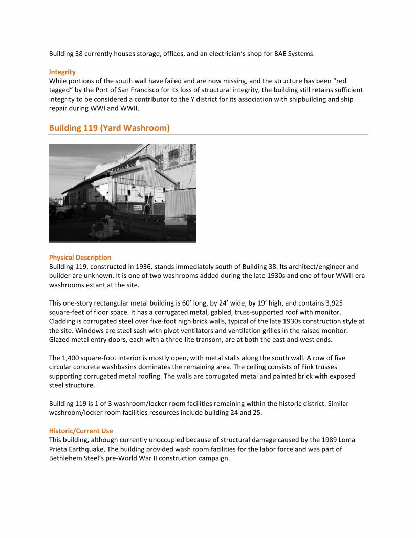
Building 119 (Yard Washroom)
Physical Description Building 119, constructed in 1936, stands immediately south of Building 38. Its architect/engineer and builder are unknown. It is one of two washrooms added during the late 1930s and one of four WWII‐era washrooms extant at the site. This one‐story rectangular metal building is 60’ long, by 24’ wide, by 19’ high, and contains 3,925 square‐feet of floor space. It has a corrugated metal, gabled, truss‐supported roof with monitor. Cladding is corrugated steel over five‐foot high brick walls, typical of the late 1930s construction style at the site. Windows are steel sash with pivot ventilators and ventilation grilles in the raised monitor. Glazed metal entry doors, each with a three‐lite transom, are at both the east and west ends. The 1,400 square‐foot interior is mostly open, with metal stalls along the south wall. A row of five circular concrete washbasins dominates the remaining area. The ceiling consists of Fink trusses supporting corrugated metal roofing. The walls are corrugated metal and painted brick with exposed steel structure. Building 119 is 1 of 3 washroom/locker room facilities remaining within the historic district. Similar washroom/locker room facilities resources include building 24 and 25. Historic/Current Use This building, although currently unoccupied because of structural damage caused by the 1989 Loma Prieta Earthquake, The building provided wash room facilities for the labor force and was part of Bethlehem Steel’s pre‐World War II construction campaign.

Integrity The building retains a high degree of integrity. This is a contributing resource because of its associations with the construction of worker facilities prior to WWII.
Building 121 (Drydock Office)
Physical Description This building stands in an open area north of Building 105. Originally constructed in 1941, it was moved before 1975 from its original location near Building 6, where it was designed to fit between two structures so as not to impede traffic on the dock. This single‐story, freestanding, flat‐roofed wood frame office building is clad in shiplap siding and has an irregularly shaped six‐sided footprint that contains 584 square feet. The building has a variety of opening types. Doors are wood; they are found at the east, the short north wall, and the west elevations. Windows along the east and northeast elevations are continuous bands of multi‐lite wood sash, while the western façade features three high, four‐lite wood sash. The interior of this small two‐room structure has lost integrity due to extensive interior modifications. Historic/Current Use Building 121 originally served as a Timekeeper’s Office. It remains in use as a field office by BAE Systems. Integrity Despite a move that postdates the period of significance, the building retains integrity of design,
materials, workmanship, feeling, and association. While it retains an industrial context, its move to an
open site, rather than a constrained one, renders the building’s odd shape meaningless. This building
retains sufficient integrity for inclusion in the historic district, relating to the increased need of
management oversight at the wharves during WWII.

HISTORIC CORE (ORTON)
Building 40 (Employment Office)
Physical Description Building 40 is located on Illinois Street, behind Building 101, the Main Office. This is a Bauhaus/Moderne‐style, three‐story rectangular structure with a flat roof and two‐story, angled glazed entry feature. It measures 95’‐9” long, by 41’‐9” wide, by 34’‐6” tall and contains 8,259 square‐feet. The building stands adjacent to a retaining wall at Illinois Avenue, with two stories above street level and the main entry at the second floor. A bridge flanked by plain, six‐foot high stucco walls provides access to the building entry from Illinois Avenue. The door surround is faceted, with a simple, projecting overhang above. A glazed, two‐story, beveled‐corner stairhall stands behind the entry door, dominating the façade. Horizontal‐paned, vertical wood window sash form the cladding of this stairhall. The body of the building, extending north from the entry, is a simple, stucco‐clad, rectangular block. The double hung windows are arranged in groups of two or three, with simple, horizontal bands of scored stucco relief. The interior contains three stories. The building contains offices arranged off of double‐loaded corridors. The main staircase is at the south end, with a smaller exit stair near the building’s north end. The main entrance from Illinois Street enters the building at the south end of the second floor. The main entry door opens into a waiting room/lobby. A partition with transaction windows separates the waiting room from an open office area – glazing remains at one opening, and although broken, the words “Employment Information” are still visible. The remainder of this floor contains smaller offices. From the waiting room, the main staircase ascends to the third floor. This part of the stairs – from the second floor to the third – is surrounded by windows (now boarded over) such that the space would have been flooded with light. The windows continue into a small, third floor lobby. The remainder of this floor, like the other two, is devoted to offices. Historic/Current Use This building was an employment office annex used for interviewing and processing the paperwork of the thousands of employees during WWII. On the March 1945 site plan, this building is labeled “Steel Office.” Building 40 is currently vacant.

Integrity This building is a district contributor for its association with the increase of facilities necessary for
managing the vast influx of WWII workers at the yard. The exterior of the building retains sufficient
integrity to be included as a district contributor. The interior was inaccessible because of condition‐
related safety concerns.
Building 117 (SF Shipyard Training Center – Warehouse No. 9)
Physical Description Building 117 stands south of the complex created by Buildings 113/114, 115/116 and 102. Together with Building 14, forms a large courtyard space (see accompanying site map). Constructed in 1937/41, Building 117 is a wide, one‐story warehouse structure located between the remnants of Irish Hill to the south and Building 116 to the north. It measures 240’ long, by 131’ wide, by 45’‐6” high at the gable, and contains 30,940 square‐feet of floor space. The architect and builder are unknown. Corrugated, galvanized iron siding clads both the exterior walls and roof of the building. A shed addition attaches to the south elevation. Continuous bands of multi‐lite steel sash windows stretch across each elevation, some with operable central vent sash. A personnel door opens at the north corner of the east elevation, and a large roll‐up metal door on the east corner of the north elevation allows freight to be transferred to the warehouse interior. Painted signage underneath the east gable reads, “San Francisco Shipyards Training Center.” This signage dates from the 1990s. The roof consists of steel decking over steel roof rafters, spanning modified Pratt trusses. The trusses are supported by a central row of steel I‐section columns. Industrial incandescent light fixtures and corrugated plastic skylights light the interior. The slab‐on‐grade floor is covered with asphalt. The floor inclines to the south and the entire south bay is elevated approximately eighteen inches. Railroad rails run from the loading door at the northeast corner to the raised area at the southeast corner. Crane tracks attach to the roof, running east to west for the length of the building. The west wall has concrete infill spanning between steel columns. The north wall is contiguous with Building 116 and is composed primarily of concrete infill; wood infill at the west end indicates a blocked access door to the adjacent building. Historic/Current Use Building 117 is listed in the 1945 Site Plan as a “Warehouse.” It still serves as a storage building.

Integrity The building retains integrity, having experienced few alterations. Building 117 contributes to the
historic district for its relationship with sweeping site upgrades prior to WWII and its association with
the influx of new workers during WWII.
CRANE COVE PARK (PORT)
Building 30 (Template Warehouse)
Physical Description Building 30, just south of Building 49, stands in the northwest quadrant of the Union Yard. It runs in northeast‐southwest direction parallel and adjacent to Slip 4 and in 1945 adjoined a welding platform. A crane stands to the east of this building, along Slip 4. Constructed in 1941, the architect and builder are unknown. This is a tall, single story, rectangular warehouse that measures 61’ long by 18’ wide by 25’6” high, and contains 991 square‐feet. It has a flat roof and corrugated metal‐clad walls. The northwestern elevation features three bays of windows covered with plastic sheeting. The northeastern elevation has a large, rectangular ground‐level opening. A shed extension with a personnel door and several windows attaches to the southwestern elevation. Three large openings covered with metal panels comprise most of the southeastern elevation. The building is purely utilitarian and lacks ornamentation. The main interior space is a single‐story with elevated wooden walkways supported by metal straps hanging from the ceiling. Corrugated metal and plastic sheeting clad the wood frame, with wood panels along the southwestern wall of the attached shed. The floor and foundation are concrete. Wooden access ladders to the elevated wooden walkways mount to the southern corner and along the southeast wall. The wooden shed extension, one step lower than the main space, contains two rectangular office spaces. Building 30 is 1 of 2 template warehouses remaining within the historic district. A similar template warehouse resource includes building 32.

Historic/Current Use The Template Warehouse, Building 30, stored wooden templates used to mark the steel hull plates at Building 109. It is one of two extant template warehouses in the district. Used in the production of multiple hulls of the same design, the templates could be reused several times. Building 30 is currently unused. Integrity Alterations include a shed addition to the south elevation, and the replacement of some windows with plastic sheeting. These changes do not significantly compromise the integrity of the building; therefore, Building 30 contributes to the district for its association with the WWII shipbuilding effort at the site.
Building 50 (Pier 68 Substation #2)
(Building 50 is the structure at the right) Physical Description Building 50 is a single story, steel frame building standing to the north of Building 110, near Slip No. 4. It is 30’ long, 25’ wide, and 23’ tall with a square floor plan encompassing 678 square feet. Similar to Buildings 103 and 110, this building has a high brick base below a band of multi‐lite, steel sash windows with operable awning ventilators, and corrugated galvanized iron cladding. Metal railing runs along the flat roof, surrounding roof‐mounted electrical equipment. This area was originally enclosed with wire. Building 50 is 1 of 8 WWII era steel frame warehouses clad with corrugated galvanized iron. Similar warehouse buildings include buildings 16, 19, 25, 32, 36, 64, and 66. Historic/Current Use Building 50 was erected by the government in 1941 when the yard was expanding in response to WWII. It is one of three extant substations built by the government on the site during WWII. It provided electrical power to Slip No. 4, nearby support buildings, and the welding shed. This building is currently vacant. Integrity Building 50 is a contributing building to the district for its association with the expansion of electrical
distribution in response to the WWII build‐out of the shipyard. Specifically, Building 50 allowed for
welding facilities to be installed at Slip No. 4. It retains its integrity of location, design, materials, setting,
workmanship, feeling, and association.

WATERFRONT SITE (FOREST CITY)
Building 11 (Tool Room and Office/Noonan Building)
Physical Description Building 11 stands just east of Building 21 and west of a paved parking lot, accessed by a road to the north. The infilled Slips 5 through 8 are to the southeast, and the Building 12 complex is to the southwest. Located on the site of the Pacific Rolling Mills sheet and tin plate warehouse, Building 11 was built in 1941 by the Navy as part of the New Yard to aid in production related to World War II.7 This three‐story rectangular wood frame building is 156’ long by 72’ wide by 38’ high, containing 32,664 square feet. It has a flat tar and gravel roof, and is clad with horizontal wood siding. Two stair towers project one story above the roof. Windows are wood double‐hung with simple wood surrounds, often paired. Exterior open staircases at the west and north elevations lead to small landings and doors at the second story. Doors include single metal units at each elevation, a wood freight door centered in the east elevation, and a sliding metal door at the north. The interior currently includes artist studios and office space. First floor spaces open directly to the exterior, without internal circulation. Exterior stairs access the second floor double‐loaded corridor, while interior winding stairs connect the second and third floors. Corridors feature resilient sheet flooring, plaster walls, glue‐up acoustical tile ceilings, simple wood door and window trim, and wood baseboards. Office doors at the second level are glazed, with a central, large rectangular lite. Third floor corridors are similar to the second, and walls are finished with vertical tongue‐and‐groove wood paneling and topped with a grid‐like transom. Wood‐paneled office doors at this level are glazed with frosted glass. At least one space retains original light fixtures, and a large safe with a hand‐painted door is located on the third level as well. Historic/Current Use Building 11 provided support for hull construction at the Building 12 Complex. The first floor originally contained a tool room, temporary lights department, and burner department, as well as three small offices. The two upper floors were devoted to office space.8 Interior signage indicates that the offices were used by the United States Navy. The building contained a cafeteria as well. Currently, artist studios and offices occupy the building.

Integrity While the building has sustained minor alterations, mostly on the interior related to change of use, it maintains a high degree of integrity of location, setting, feeling, and association; and a moderate degree of integrity of design, materials, and workmanship. Therefore, it is a contributing resource for its association with World War II.
Building 15 (Layout Yard)
Physical Description Building 15 stands at the south end of the site and is part of the Building 12 Complex. The group, including Buildings 12, 15, 16, 25, 32, and 66, was constructed in 1941 – 1944 specifically for WWII. The architect/engineer and builder are unknown, but the building was likely designed and built by government personnel as part of the joint WWII effort. This east‐west oriented warehouse stands immediately adjacent to Building 12 and measures approximately 242’ 8” x 71’ 7”, with an interior area of 17,134 square‐feet. A fink truss with a kingpost supports the gabled roof, with the peak approximately 53’ off the ground. Nine columns along the interior walls subdivide the space into eight distinct bays. The gabled roof covers the seven eastern bays; a flat roof of wood joists and decking covers the eighth, westernmost bay. A steel staircase on the south exterior wall leads to the flat roof, and a personnel platform on the roof rises slightly above the steel parapet. Part of the Building 12 Complex constructed specifically for WWII, Building 15 attaches to four other buildings, three to the south (Buildings 32, 25, and 16) and one to the north (Building 12), leaving only the eastern and western ends exposed. On the interior, no significant walls or partitions separate Building 15 from Buildings 12 or 32, creating a unified interior space between the three buildings, although at the northeast corner of Building 15 a corrugated steel wall with multi‐lite steel sash windows partially divides the easternmost bay from Building 12. The southern interior wall features a cut‐out through the corrugated steel that reveals the exterior north elevation of Building 25. Short wood planking serves as a roof over the approximately one foot gap between the two buildings. Two wood personnel doors on either side of the Building 25 cut‐out provided access between the two buildings. Where Building 16 and Building 15 meet, newer corrugated steel covers the wall and non‐corrugated steel panels cover the wall at ground level. Standard industrial light fixtures, apparently original, remain.

On the exterior, the upper portion of the western façade features a corrugated steel parapet above a continuous band of multi‐lite, steel sash pivot windows spanning the entire façade width. A similar band of windows glazes the ground level, interrupted by a large vehicle door in the central bay. Most of the southern elevation attaches to smaller buildings, but the western end of this elevation features a band of multi‐lite windows above a vehicle door large enough for rail cars. The eastern elevation includes a band of multi‐lite steel sash pivot windows at the upper level, and a roll‐up steel door at the ground level. All of the northern façade attaches to Building 12. Historic/Current Use The Layout Yard served as an intermediate staging area for the steel plates of a vessel’s hull used for hull construction in Slips 5‐8. As the plates left the Plate Shop (Building 12) adjacent to the north, they were arranged, numbered, and checked against the molds and plans. This process assured that the welders had the correct panels lined up for welding. This occurred on either one of the welding platforms, if preassembled, or directly on the hull of the ship in one of the slips adjacent to the east. U. S. Navy‐owned rail lines transported the steel plates to the welding platforms and slipways of the New Yard. The personnel platform and stairs leading up to the flat roof on the western edge of the building indicate a potential use as a viewing platform to oversee activities in the plate storage yard to the west. These former staging areas remain between Building 12 and the remnant of Irish Hill to the west. The building is vacant. Integrity Building 15 contributes to the Union Iron Works/Bethlehem Steel Shipyard because of its association with the WWII steel shipbuilding effort undertaken at the New Yard. Building 15, the Layout Yard, has experienced few alterations and retains integrity of location, design, setting, materials, workmanship, feeling, and association.
Building 16 (Stress Relieving Building)
Physical Description Building 16, located at the south end of the site, is part of the Building 12 complex, comprised of Buildings 12, 15, 16, 25, 32, and 66. It was constructed in 1941 specifically for the WWII effort. The architect and builder are unknown, but it was designed and built by government personnel as part of the joint WWII effort.

This two‐story gabled warehouse measures 50’‐10” by 152’‐2” in plan and 45’7” in height. It contains a total of 7,588 square‐feet, and corrugated steel panels cover the steel frame. Five prominent vents run along the gable ridge. The upper portion of all exposed facades features a band of multi‐lite, steel sash awning windows with operable vents near the top of the building. The eastern façade (which currently faces an Auto‐Return parking lot) has five bays and two roll‐up steel doors that interrupt a lower band of windows. The southern façade, divided into three bays, is almost entirely covered with steel sash windows, and has a single steel personnel door. The western façade, visible from a courtyard formed by neighboring Buildings 15 and 32, reveals more multi‐lite, steel sash windows and two metal personnel doors with windows. The interior consists of one open bay, with a concrete foundation and a double‐height ceiling approximately 33’ 7” from the ground. An exposed steel compound Fink truss with a kingpost top forms the gable, which rises an additional 12’. The former entrance from Building 16 into Building 15 now appears covered with metal panels. Some standard factory light fixtures remain. Along the western façade a large industrial furnace with a gable roof approximately 20’ tall attaches to Building 16. The furnace features steel‐framed doors at the east and west elevations, with the eastern door opening directly into Building 16. The doors slide vertically into a protected compartment, and fire brick appears through holes in the doors. Four hydraulic actuators to tightly seal the furnace wrap around the door’s perimeter. A chimney stands along the southern side, and numerous exposed mechanical systems envelop the north and south elevations of the furnace. Building 16 is 1 of 8 WWII era steel frame warehouses clad with corrugated galvanized iron. Similar warehouse buildings include buildings 19, 25, 32, 36, 50, 64, and 66. Historic/Current Use The Stress Relieving Building was used for hull construction at the Building 12 Complex. Related to quality control, pre‐assembled welded components for ship hulls assembled in Slips 5, 6, 7, or 8 would have joints relieved of the stress inherent in the bond from imperfect welds. Stress relieving involved re‐heating the bond juncture, burning the ridge and inserting a splint or “strong back” mechanically and re‐welding the joint in a controlled environment. The building is currently vacant. Integrity Building 16, the Stress Relieving Building, has experienced few alterations and retains integrity of location, design, setting, materials, workmanship, feeling, and association. Building 16 contributes historic district for its association with the WWII steel shipbuilding effort at the New Yard. The industrial furnace connected to this building is also a character‐defining feature and is the only example of this type of furnace at the site.

Building 19 (Garage #1)
Physical Description Building 19, just south of Building 108, is surrounded by open space on the east, west and south elevations. This building stands at the end of 20th Street, which was closed during WWII. Built in 1941, the architect and builder of this simple, industrial structure are unknown. This is a one‐story, rectangular‐plan gable‐roofed warehouse with corrugated, galvanized steel roofing and cladding. It measures 50’‐8” x 24’‐6” in plan and 31’‐6” tall, and contains a total of 6,152 square‐feet. Windows are fixed, multi‐lite steel sash with central ventilators; many lites are boarded or painted over. Rolling metal doors appear on the west, east and south elevations. The north elevation is board‐formed concrete and stands higher than the adjacent east and west. A small metal shed attaches to the west elevation. The interior is a single open space. Walls are corrugated metal, except for the concrete north wall. Modified Howe trusses form the roof structure and the floor is concrete slab. Freestanding machinery includes a sifter/conveyor, and the building stores sandblast grit, used to sandblast ships prior to painting. Building 19 is 1 of 8 WWII era steel frame warehouses clad with corrugated galvanized iron. Similar warehouse buildings include buildings 16, 25, 32, 36, 50, 64, and 66. Historic/Current Use Listed as Garage No. 1 and owned by the Government on the Bethlehem 1945 plan, this building was used as a garage and housed a small office during WWII. It adjoins Building 108, a planning mill and joiner shop. Building 19 is currently used by BAE Systems for storage of sandblasting grit. Integrity Despite minor alterations, such as the attached metal shed at the west elevation, the building retains a high degree of integrity and therefore is a contributing resource. Building 19 is a contributor for its association with the World War II shipbuilding effort at the yard.

Building 25 (Washroom and Locker Room)
Physical Description This single‐story, steel‐frame, gable‐roofed industrial building with corrugated metal‐clad walls measures 51’‐6” long by 29’ wide by 19’ tall, and contains 1,407 square‐feet. Built in 1941, it stands in a courtyard created by four other buildings (15, 16, 31, and a mechanical building). The northern end attaches to Building 15. A band of multi‐lite, steel sash pivot and awning windows runs continuously on three exposed elevations, approximately 8’ from the ground. Metal double doors with four‐lite glazed upper panels open on the western façade. The steel Howe truss supports the gable roof. No alterations to the plan or external materials are evident. The toilets, sinks, and urinals still line the walls, although none of them has plumbing fixtures. Most stall partitions have been removed, as have the shower stalls near the center of the room. Prominent anti‐Lyndon Johnson and anti‐NAACP graffiti remains over one of the urinals. Building 25 is 1 of 8 WWII era steel frame warehouses clad with corrugated galvanized iron. Similar warehouse buildings include buildings 16, 19, 32, 36, 50, 64, and 66. Building 25 is 1 of 3 washroom/locker room facilities remaining within the historic district. Similar washroom/locker room facilities resources include building 24 and 119. Historic/Current Use This building contains shower, bathroom, and locker facilities for the workers who labored in the adjacent buildings. Building 25 is one of the seven washroom and locker room facilities installed in 1941. It is the only example of a corrugated metal clad washroom from that period, but is similar in style to the two washrooms (Buildings 110 and 119) constructed during the late 1930s. Washrooms, lockers and lunch rooms were scattered throughout the Yard as a means of providing needed amenities to the workers where they worked, a more efficient means of running a business with hundreds of workers. Integrity Building 25, the Washroom and Locker Room, has experienced few alterations and retains integrity of location, design, setting, materials, workmanship, feeling, and association. Building 25 is a district contributor for its association with the improvement of worker amenities during WWII.

Building 32 (Template Warehouse, 1941)
Physical Description Building 32 stands at the south end of the site and is part of the Building 12 Complex (Buildings 12, 15, 16, 25, 32, and 66). The complex was constructed from 1941 – 1944, specifically for WWII, as part of the New Yard. This building stands on the former location of Irish Hill. The architect and builder of this 1941structure are unknown, but it was likely designed and built by government personnel as part of the joint WWII effort. This single‐story, semi‐attached, rectangular warehouse with a gable roof is of steel frame construction with corrugated metal‐clad walls. It measures 100’ long by 50’ wide by 32’ high, and contains 4,900 square‐feet. Its northern end attaches to Building 15. Exposed steel compound Fink trusses with a king post form the gable and create a clear interior space with no support columns. The western façade features two rows of four, evenly space rectangular multi‐lite steel sash awning windows with steel sills. The southern façade contains vents and a metal personnel door with four window panes. Multi‐lite steel sash windows can be seen on the eastern façade from the courtyard formed by neighboring Buildings 15 and 16. Wood planking, exposed on the interior and covered with roll roofing at the exterior, clads the roof. Two prominent vents sit on the gable ridge. The interior ground floor has been repaved with asphalt and any mechanical and/or template storage racks have been removed. Many small standard factory light fixtures remain intact. Architectural plans illustrate a mezzanine that wrapped around the entire second story, with offices in the northeast and northwest corners. The mezzanine rose 10’ from the floor and sat 11’ from the bottom of the trusses. Little evidence of the mezzanine or offices remains, except for a belt of steel beams that runs around the interior perimeter at approximately 10’ from the floor. Building 32 is 1 of 2 template warehouses remaining within the historic district. A similar template warehouse resource includes building 30. Building 32 is 1 of 8 WWII era steel frame warehouses clad with corrugated galvanized iron. Similar warehouse buildings include buildings 16, 19, 25, 36, 50, 64, and 66.

Historic/Current Use The Template Warehouse, Building 32, stored wooden templates used in shaping steel hull plates at the Building 12 Complex. It is one of two extant template warehouses at the yard. Used in the production of multiple hulls of the same design, the templates could be reused several times. Integrity Building 32, the Template Warehouse, has experienced few alterations and retains integrity of location, design, setting, materials, workmanship, feeling, and association. Building 32 contributes to the historic district for its association with the WWII shipbuilding effort at the New Yard.
Building 66 (Welding Shed, c. 1945)
Physical Description Placed to the northeast of Building 12, Building 66 marks the northern end of the Building 12 Complex, a series of five buildings constructed specifically for the WWII effort (Buildings 12, 15, 16, 25, 32, and 66). The Bethlehem Steel Company’s 1945 architectural plans indicate that the federal government erected a welding platform on the site in 1941, but the plans do not show a shed. The shed first appears in a 1945 aerial photo. Its architect and builder are unknown. This large, rectangular plan, two‐story, steel frame shed with corrugated metal siding measures approximately 220’ long by 105’ wide and covers 23,100 square‐feet. It is almost completely open on the north and south ends, providing an unobstructed north/south view through the building. Columns divide the space into eleven vertical bays, and Pratt trusses support the roof gable. Along the west elevation, an attached men’s locker room, measuring approximately 15’ x 60’, sits outside the main bay of Building 66. At some point (after the period of significance), the locker room’s north end sustained significant damage, with the roof torn off and the interior exposed to the elements. Two personnel doors from the locker room opened to the west and one opened to the east, into the main Welding Shed bay. Almost all interior fixtures have disappeared, but a few toilets, urinals, and a prominent “Men Only” sign stenciled on a western door remain in place. Large, angled support columns for Building 66 penetrate the locker room, dividing the space into distinct bays. The locker room roof, approximately 15’ high along the western wall, slopes down eastward at an approximately 15˚ angle. Translucent roof panels provided interior lighting.

At the east corner of the northern elevation, a sliding vehicle door on an overhead track remains standing, supported by horizontal beams. No other steel panels surround the door, although a personnel door opens through the vehicle door. Note that this Building 66, as described here, differs from the Building 66 as described on the 1945 Bethlehem Steel map. That plan shows a small building north of Wet Basin No. 7, which housed Dry Dock No. 2. The building was called the “No. 2 Drydock Building.” The present building’s appearance in the 1945 aerial photo places it within the period of significance. Building 66 is 1 of 8 WWII era steel frame warehouses clad with corrugated galvanized iron. Similar warehouse buildings include buildings 16, 19, 25, 32, 36, 50, and 64. Building 66 is 1 of 2 welding shops remaining within the historic district. A similar welding shop resource includes building 36. Historic/Current Use Building 66 was used for welding preassemblies and other hull components during hull construction at the Building 12 Complex and Slips 5‐8. When Building 66 was constructed in 1945 on land that was formerly part of the Pacific Rolling Mills lands, most of the yard was used for the production of war vessels. This open building sheltered outdoor activities so that the welding work would not have to depend on good weather. Integrity Building 66, the Welding Shed, has experienced few major alterations and retains its original spatial qualities. Therefore, it retains integrity of location, design, setting, materials, workmanship, feeling, and association, and contributes to the Pier 70 historic district for its association with the WWII shipbuilding effort at the New Yard.
RATIONALIZE EXISTING DEVELOPMENT PATTERNS (PORT) DEVELOPMENT PATTERNS (PORT) Building 36 (Welding Shop)
Physical Description Building 36, the Welding Shop, is located between Buildings 104 and 52/109. Open, paved areas used for parking and storage surround the building on all sides. Built in 1941, the architect and builder are unknown.

This rectangular metal industrial structure measures 200’ long by 60’‐9” wide and 47’ high. It has an east‐west axis and contains 12,050 square‐feet. Both the walls and the gable roof are clad in corrugated, galvanized iron. A 17’‐9” high shed extension runs along the entire south elevation. Windows are multi‐lite steel sash, with operable central ventilators, and consist of 16‐ or 20‐lite panels arranged in rows of three or four. At the shed extension, windows are tall, 28‐lite units in groups of three. Some windows at the north elevation are now covered with metal sheeting, and others, at the shed‐roofed extension, have been altered as doorways. The interior consists of an open area with a row of steel columns that separate the shorter, southern shed extension from the main space. Walls consist of the exposed steel structure, with the exterior corrugated steel cladding behind. The main roof structure is a series of compound fan trusses overlaid with corrugated metal cladding. Simple triangular trusses support the shed‐roof over the southern extension. The floor is concrete and in good condition. Four swing‐out, one‐ton cranes extend from the north wall, and two mount to the south. Double tracks for working 10‐ton cranes run along both the east and west ends. Sliding metal freight doors in the east wall and double metal doors in south extension access the space. A personnel door and a soldered shut freight door penetrate the west wall. An office occupies the southeast corner. Building 36 is 1 of 8 WWII era steel frame warehouses clad with corrugated galvanized iron. Similar warehouse buildings include buildings 16, 19, 25, 32, 50, 64, and 66. Building 36 is 1 of 2 welding shops remaining within the historic district. A similar welding shop resource includes building 66. Historic/Current Use As part of the hull construction process during WWII, this building was originally used for welding preassemblies that were then moved to the slipways, Slips 1‐4, using Bethlehem Steel‐owned rail lines. Building 36 is currently in use as a machine shop by BAE Systems after the ship repair company moved out of Building 113. Integrity Building 36, the Welding Shop, has experienced few alterations and retains integrity of location, design,
setting, materials, workmanship, feeling, and association. Building 36 contributes to the historic district
for its association with shipbuilding during WWII.
REMOVAL OF NAVIGATIONAL HAZARDS (PORT)
Pier 70, including Bldg. 64 and Wharf No. 8
Pier 70
Wharf 8
Bldg. 64

Physical Description Pier 70 extends eastward into the bay near Building 6 and directly north of Slips 5 through 8. The pier consists mainly of wood decking over wood piles, and the decking has collapsed or is collapsing in many areas. Wharves 6, 7, and 8 project northward off the pier, creating Wet Basins 6 and 7. Wharves 6 and 7 are constructed of wood piles supporting wood decking and are missing most of the wood decking and large portions of their wood piles. Viewed from above, a rough outline of the wharves is still visible, but from many perspectives in the district even the rough footprint of these two wharves is no longer discernible. Wharf 8 was rebuilt with wood decking, concrete, and steel after 1980 as a fuel dock, and is currently in poor condition. Historic/Current Use Since the late nineteenth century, piers and wharves have been erected and replaced in the vicinity of Pier 70. The first pier was constructed by the Pacific Rolling Mills in the late nineteenth century. Risdon Iron Works appears to have expanded this pier during the early twentieth century. Piles associated with these piers are likely mixed in with the piles from Wharf 6 or Pier 70. The western end of Pier 70 appears to date to World War I; however, portions of the turn of the twentieth century Risdon pier may have been incorporated. The 1936 Sanborn Map shows little change to the pier from the 1914 Sanborn Map. The pier was extended and Wharves 6, 7, and 8 were added during World War II. Therefore, most of the extant wharves and wet basins of Pier 70 date to World War II and were owned and built by the U.S. Navy. The pier was strengthened in 1941 and widened in 1942 and 1944. Wharf 6 originally extended northward off the eastern edge of Pier 68 in 1920. It was extended southward to join with Pier 70 in 1941, creating Wet Basin 6. This wharf was widened toward the west in 1943 and 1945. A rail line on Wharf 6 connected Pier 68 and Pier 70, and crane rails also extended down the wharf. Wharf 7 was 1,674 feet long with a rail and crane track to move materials onto and along the wharf. Wharf 8 was originally constructed in 1944 and rebuilt in the 1980s. It consists of wood decking over a structural steel frame on steel cylinders filled with concrete. These waterfront features are no longer in use. Integrity Pier 70, Wharves 6 and 7, and Wet Basins 6 and 7 are associated with the expansion of the yard during
World War II. Portions of Wharves 6 and 7 have collapsed into the bay and have lost their integrity of
design, workmanship, materials, and feeling. Due to the loss of these wharves, the associated wet basins
are no longer discernible and have also lost their integrity. Wharf 8 was rebuilt outside of the period of
significance. None of these waterfront structures is a contributing resource. The removal of the
buildings between the Building 12 Complex and Building 6, which provided support for workers, has also
impacted the setting of these piers and wharves.