anaerobic digestion plant park farm mapledurham...
TRANSCRIPT
Anaerobic Digestion Plant Park Farm
Mapledurham Oxon
for Gasson Associates
on behalf of
Mapledurham Estate for BTS Biogas Ltd
CA Project: 770243
CA Report: 15561
July 2015

Anaerobic Digestion Plant
Park Farm Mapledurham
Oxon
Archaeological Excavation
CA Project: 770243 CA Report: 15561
This report is confidential to the client. Cotswold Archaeology accepts no responsibility or liability to any third
party to whom this report, or any part of it, is made known. Any such party relies upon this report entirely at their own risk. No part of this report may be reproduced by any means without permission.
© Cotswold Archaeology
Document Control Grid Revision Date Author Checked by Status Reasons for
revision Approved
by A 8-7-15 Ray
Kennedy DDR Internal
review DDR
B 29-7-15 DDR DDR Draft for client review
O&A JD

© Cotswold Archaeology
1
Park Farm, Mapledurham, Oxon :Archaeological Excavation
CONTENTS
SUMMARY ..................................................................................................................... 3
1. INTRODUCTION ................................................................................................ 4
2. ARCHAEOLOGICAL BACKGROUND ................................................................ 6
3. AIMS AND OBJECTIVES ................................................................................... 8
4. METHODOLOGY ............................................................................................... 8
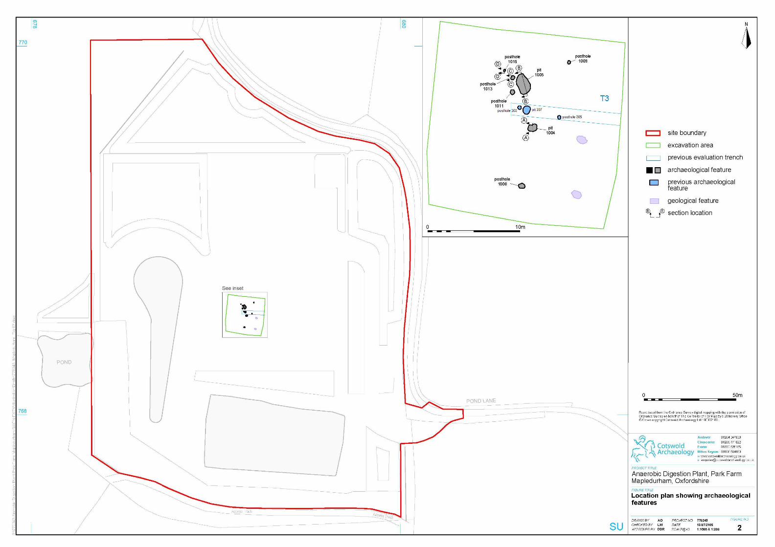
5. RESULTS (FIGS 3–6) ........................................................................................ 10
6. THE FINDS ........................................................................................................ 11
7. DISCUSSION ..................................................................................................... 12
8. CA PROJECT TEAM .......................................................................................... 13
9. STORAGE AND CURATION .............................................................................. 13
10. REFERENCES ................................................................................................... 13
APPENDIX A: CONTEXT DESCRIPTIONS ................................................................... 14
APPENDIX B: FINDS ..................................................................................................... 14
APPENDIX C: OASIS REPORT FORM .......................................................................... 15
© Cotswold Archaeology
2
Park Farm, Mapledurham, Oxon :Archaeological Excavation
LIST OF ILLUSTRATIONS
Fig. 1 Site location plan (1:25,000)
Fig. 2 Location plan showing archaeological features (1:2000)
Fig. 3 Pit 1004, sections and photographs (1:20)
Fig. 4 Pit 1005, sections and photographs (1:20)
Fig. 5 Posthole 1013, sections and photographs (1:20)
Fig. 6 Posthole 1015, sections and photographs (1:20)
Fig. 7 Working Shot
Fig. 8 Working Shot

© Cotswold Archaeology
3
Park Farm, Mapledurham, Oxon :Archaeological Excavation
SUMMARY
Project Name: Park Farm, Mapledurham, Oxfordshire
Location: Mapledurham, South Oxfordshire District Council
NGR: S468095, 176655
Type: Strip, Map, Record
Date: 6 July to 7 July 2015
Planning Reference: P14/S0477/FUL
Location of Archive: Oxfordshire Museums
Site Code: DPM 15
An archaeological excavation was undertaken by Cotswold Archaeology in July 2015 at Park
Farm, Mapledurham, Oxfordshire. The archaeological excavation was undertaken within a
20m x 20m area centred and targeted on archaeological features recorded in a previous
evaluation of the site.
The excavation identified four undated possible postholes and three pits. All three of the pits
were of indeterminate function but are possibly refuse pits, probably associated with activity
in the surrounding landscape. Two of the pits contained pottery, which have been dated to
the Iron Age period, while the third pit was undated.
It cannot be definitively stated whether the postholes were associated with the pits or
whether they are from activity in a later period as the postholes did not contain any dateable
material.
The features recorded are likely to indicate possible settlement and/or agricultural activity
dating to the Iron Age period in the wider vicinity of the site.

© Cotswold Archaeology
4
Park Farm, Mapledurham, Oxon :Archaeological Excavation
1. INTRODUCTION
1.1 In July 2015, Cotswold Archaeology (CA) carried out an archaeological strip, map
and record excavation on land at Park Farm, Mapledurham, Oxfordshire (centred at
NGR: S468095, 176655; Fig. 1) at the request of Gasson Associates on behalf of
the Mapledurham Estate for BTS Biogas Ltd.
1.2 Conditional planning permission (Ref: P14/S0477/FUL) has been granted by South
Oxfordshire District Council (SODC) the Local Planning Authority for an Anaerobic
digestion (AD) plant with access and associated development including an electrical
connection to the local electricity distribution network (Re-submission of withdrawn
application P13/S1290/FUL) (As amended by drawing 616.1/09A and clarified by
drawing 616.1/11).
1.3 Conditions 9 and 10 relate to archaeology and state:
Condition 9 A professional archaeological organisation shall prepare an Archaeological Written
Scheme of Investigation relating to the site area, which shall be submitted to and
approved in writing by the Local Planning Authority prior to the commencement of
the development hereby approved.
Reason: To secure the protection of and proper provision for any archaeological
remains in accordance with Policy CSEN3 of the South Oxfordshire Core Strategy
2027 and Policies CON11, CON13 and CON14 of the South Oxfordshire Local Plan
2011.
Condition 10 Following the approval of the Written Scheme of Investigation referred to in
Condition 9, and prior to the commencement of the development hereby approved
(other than in accordance with the agreed Written Scheme of Investigation), a
staged programme of archaeological evaluation and mitigation shall be carried out
by the commissioned archaeological organisation in accordance with the approved
Written Scheme of Investigation. The programme of work shall include all
processing, research and analysis necessary to produce an accessible and useable
archive and a full report for publication which shall be submitted to the Local
Planning Authority prior to the first use of the development hereby approved.

© Cotswold Archaeology
5
Park Farm, Mapledurham, Oxon :Archaeological Excavation
Reason: To secure the protection of and proper provision for any archaeological
remains in accordance with Policy CSEN3 of the South Oxfordshire Core Strategy
2027 and Policies CON11, CON13 and CON14 of the South Oxfordshire Local Plan
2011.
1.4 A Heritage desk-based assessment (BSA 2013) and trial trench evaluation (FA
2014) were undertaken in order to inform the [previous] application.
1.5 Following consultation by SODC with their archaeological planning advisor, the
County Archaeologist Richard Oram at Oxfordshire County Council (CAOCC) in
regard of the withdrawn application P13/S1290/FUL, which has been superseded
by P14/S0477/FUL to BFC, it was recommended in an email (dated 28 January
2014 and detailed in section 5.6.3 in a planning statement for the site (HDA2014))
from the County Archaeologist Richard Oram that based on the results of the
archaeological evaluation (FA 2014) that a strip map and recording action should be
undertaken particularly around the area of trench 3. The reasons given for the
recommendation were that although the evaluation report suggested a possible
former fence line, this does not appear to relate to a modern fence. As a watching
brief over this area would struggle to pick up further post holes a strip map and
recording action was therefore recommended.
1.6 The excavation was undertaken in accordance with a detailed Written Scheme of
Investigation (WSI) produced by CA (2015) and approved by Oxfordshire County
Council Archaeological Services. The fieldwork also followed Standard and
Guidance: Archaeological Excavation (CIfA 2014); the Management of
Archaeological Projects (English Heritage 1991) and the Management of Research
Projects in the Historic Environment (MORPHE): Project Manager’s Guide (English
Heritage 2006).
The site
1.7 The site is c.3.5ha in size and is currently part of an arable field, which contains a
slurry lagoon at the south. It is bounded to the south and southwest by Park Wood,
to the east by Pond Lane and to the north by other areas of the arable field (Fig. 1).
1.8 The site is generally level at a height of c.97.50 to 98m above Ordnance Datum
(aOD), but falls away slightly to a height of c.96m aOD along the western boundary
of the site.

© Cotswold Archaeology
6
Park Farm, Mapledurham, Oxon :Archaeological Excavation
1.9 The underlying geology comprises Lambeth Group - clay, silt and sand overlaid by
Winter Hill Gravel - sand and gravel (BGS online viewer). The natural gravel and
clay substrates were encountered during the archaeological evaluation at an
average depth of 97.35m OD (c. 0.37m below ground level)
2. ARCHAEOLOGICAL BACKGROUND
Introduction
2.1 An archaeological desk-based assessment within a 1km study area of the site was
undertaken by BSA Heritage (BSA 2013). The results of this assessment are
summarised below.
Desk-based assessment
2.2 A number of chance finds recorded in the Oxfordshire HER suggest human activity
from early Prehistory in the vicinity of the site. Mesolithic, Neolithic and Bronze Age
artefacts have also been recovered near Mapledurham.
2.3 The earliest possible features recorded within the study area are a series of
cropmarks lying immediately east of the site. These sub-surface features have been
noted from aerial photographs and their shape suggests they reflect remains of a
Prehistoric or Roman field system (HER 15341).
2.4 A central double linear runs from northeast to southwest and is aligned with an
extant lane to the south and ‘Broad Street Shaw’ to the north. This suggests that
this element of the cropmarks reflects a Post-medieval route. Other linear marks to
either side of this ‘lane’ may well be earlier and have the typical morphology or
appearance of Roman or later Prehistoric field systems. There are no marks
indicative of dwellings or other domestic activity amongst these cropmarks.
2.5 HER 26229 relates to the find of a single Roman bronze coin and is located close to
the cropmarks, north of the site. However, the grid reference given is actually vague
and the find was apparently made in a back garden of ‘4 Chase Close’. It is likely
that the find was some distance away and so does not support a Roman date for
the cropmarks in itself (Berkshire Archaeological Journal 1966). However, under
HER 4064, which is a medieval moat lying immediately west of the site, it is noted
that an AD295 Roman coin was recovered during investigation of that site in the
© Cotswold Archaeology
7
Park Farm, Mapledurham, Oxon :Archaeological Excavation
1970s. Roman coins were also recovered during dredging at Mapledurham Lock in
1910 (HER 8018).
2.6 HER 4064 records an extant moated site, immediately west of the site in Park
Wood. The feature consists of a central island surrounded by a water-filled ditch
forming a square enclosure. Such sites tend to be medieval in origin, however,
investigation in 1970 found predominantly Post-medieval remains including chalk
walling, a brick floor and roof tiles.
2.7 Documentary references suggest that Mapledurham itself had a deer park,
however, the boundary of the park is not known. Away from Mapledurham itself, at
least two of the nearby listed houses are thought to have medieval origins as cruck-
built open hall houses. These medieval survivals are the Grade II listed Mill
Farmhouse, circa 700m north of the site and Pithouse Cottages, approximately 1km
to the northeast of the site (HER 7711 and Site A).
2.8 The Oxfordshire HER records further Grade II listed buildings in the vicinity, most of
which are 17th century or later. HER 26238 records the findspot of a gold Post-
medieval coin north of the site. A large number of listed buildings are concentrated
west of the site, at Mapledurham itself. These include the Grade I listed 13th
century Church of St Margaret and late 16th century Mapledurham House (HERs
12400 & 1970).
2.9 Analysis of the available cartographic records has indicated that the site and the
surrounding area were predominately park or agricultural land in the Post-medieval
period.
2.10 The site therefore contained the potential for the presence of archaeological
features, predominately relating to the Prehistoric, Roman, Medieval and Post-
medieval periods.
Archaeological Evaluation
2.11 An archaeological evaluation of the site comprising the excavation of 6 no 30m trial
trenches was undertaken in order to investigate the archaeological potential of the
site (FA2014).
2.12 The evaluation revealed a generally dispersed set of undated features, which
comprised one possible ditch, two postholes and two possible pits, along with a
probable late medieval or Post-medieval gravel extraction pit and/or pond. The
© Cotswold Archaeology
8
Park Farm, Mapledurham, Oxon :Archaeological Excavation
majority of these features are likely to represent former agricultural activity, although
it is possible that the extraction pit/pond may have been related to a moated site,
which was located immediately west of the site.
2.13 Within trench 3 two undated postholes and an undated small pit were revealed. The
postholes were fairly similar and possibly represented part of a former fence-line.
The pit was relatively shallow and it did not contain any artefacts or charcoal. It was
not certain, therefore, if the feature was the base of a pit or, alternatively, a root-
hole. Given its location, along the line of the possible fence, it may possibly
represented evidence for a former fence-line hedge.
2.14 There was a paucity of artefacts within the trenches; a brick fragment from trench 2
and a piece of tile from ploughsoil in trench 5 were the only finds.
3. AIMS AND OBJECTIVES
3.1 The objectives of the archaeological mitigation were to:
• record the nature of the main stratigraphic units encountered
• assess the overall presence, survival and potential of structural and industrial
remains
• assess the overall presence, survival, condition, and potential of artefactual
and ecofactual remains
3.2 The specific aims of the work were to:
• record any evidence of past settlement or other land use
• recover artefactual evidence to date any evidence of past settlement that
may be identified
• sample and analyse environmental remains to create a better understanding
of past land use and economy
4. METHODOLOGY
4.1 The fieldwork followed the methodology set out within the WSI (CA 2015). The
location of the excavation area was agreed with the County Archaeologist Richard
Oram, informed by the results of the archaeological evaluation (FA 2015). An

© Cotswold Archaeology
9
Park Farm, Mapledurham, Oxon :Archaeological Excavation
excavation area measuring 20m by 20m was set out on OS National Grid (NGR) co-
ordinates using Leica GPS and surveyed in accordance with CA Technical Manual
4: Survey Manual. The excavation area was scanned for live services by trained CA
staff using CAT and Genny equipment in accordance with the CA Safe System of
Work for avoiding underground services.
4.2 Fieldwork commenced with the removal of topsoil and subsoil from the excavation
area by mechanical excavator with a toothless grading bucket, under constant
archaeological supervision. The generated spoil was monitored in order to recover
artefacts, and a metal detector was employed to enhance artefact recover. Machine
excavation ceased at the level of the natural substrate where the archaeological
horizon was observed. Hand-cleaning of the stripped surface, to better define the
identified archaeological deposits/features was undertaken at this point.
4.3 All archaeological features revealed were planned and recorded in accordance with
Technical Manual 1 Fieldwork Recording Manual (CA 2013). Each context was
recorded on a pro-forma context sheet by written and measured description;
principal deposits were recorded by drawn plans (scale 1:20), and electronically
using Leica 1200 series GPS and drawn sections (scale 1:10). Where detailed
feature planning was undertaken using GPS this was carried out in accordance with
Technical Manual 4 Survey Manual (CA 2012).
4.4 Examination of features concentrated on recovering the plan and any structural
sequences. All discrete features (post holes, pits) were 100% sampled by hand
excavation
4.5 A full photographic record was kept. The primary photographic record was captured
on Canon digital SLR equipment that at least matches the quality of a 35mm SLR
film camera. The record includes detailed images of archaeological deposits and
features and other images to illustrate their location and context, and the location
and context of the separate working areas. The record includes images of the Site
overall and working shots to illustrate the general progress of the archaeological
investigation
4.6 All finds were bagged separately and related to the context record. All artefacts were
recovered and retained for processing and analysis in accordance with Technical
Manual 3 Treatment of Finds Immediately after Excavation (CA 1995).

© Cotswold Archaeology
10
Park Farm, Mapledurham, Oxon :Archaeological Excavation
4.7 The CAOCC was provided with updates on the progress of the work and following
correspondence gave permission for the excavation area to be signed off and
backfilled.
5. RESULTS (FIGS 3–6)
5.1 This section provides an overview of the excavation results; detailed summaries of
the contexts and finds to be found in Appendices A-B.
5.2 The pottery dating evidence indicates that the majority of archaeological activity on
site dates to the Iron Age period.
5.3 Some features could not be definitively assigned a phase based on stratigraphy or
dating evidence and remained unphased and undated.
Iron Age (Figs 2, 3 and 4)
5.6 The earliest phase of archaeological activity identified during the course of the
excavation were two pits, 1004 and 1005, which contained Iron Age pottery.
5.7 Pit 1004 was sub circular in plan and had a diameter of up to 0.90m and was 0.26m
deep. It contained a single sterile fill (1003) of firmly compacted silty gravels from
which 6 sherds of Early to Middle Iron Age pottery were recovered. The pit (1004)
lay c.2m to the south of pit (307) that had previously been recorded during the
evaluation (FA 2014).
5.8 Pit 1005 was oval in plan and measured 2.10 m x 0.75m x 0.33m deep. The pit
contained a single sterile fill (1006) of compacted silty gravel from which 21 sherds
of pottery dated to the Iron Age period were recovered. The pit (1005) lay c.2m to
the north of pit (307) that had previously been recorded during the evaluation (FA
2014).
Undated (Figs 2, 5 and 6) 5.9 A number of undated postholes were also recorded within the area. Three of these
postholes 1011, 1013 and 1015 lay immediately within the vicinity of pit 1005 and
may possibly be associated with this feature in delineating a fence line or another

© Cotswold Archaeology
11
Park Farm, Mapledurham, Oxon :Archaeological Excavation
function that cannot be deduced from the evidence. Postholes 1011 and 1013 lay
immediately adjacent to Pit 1005 and were both c. 0.50m in diameter with a depth of
c.0.11m. Posthole 1015 lay to the north and was 0.32m in diameter and 0.12m
deep. Posthole 303 recorded during the evaluation would appear to be a
continuation of this line of postholes.
5.10 However, the shallow depth of these features could indicate that they have been cut
from further up in the sub and top soil sequence and may indeed be more recent in
date and unassociated with pit 1005 or pit 307.
5.11 Two further isolated postholes were recorded. To the south posthole 1008, which
was 0.38m in diameter and 0.10m deep, and in the north east of the excavation area
posthole 1009 with a diameter of 0.35m and depth of 0.09m. Again the shallow
depth of these features could indicate that they have been cut from higher up in the
sequence and are more recent in date.
5.12 The archaeological features pit 307, and postholes 303 and 305 that had previously
been recorded during the evaluation (FA 2014) were relocated and found to have
been 100% sample excavated during the course of the evaluation.
6. THE FINDS
6.1 Artefactual material from strip, map and record was recorded from two deposits (pit
fills). All of the recovered material dates to the Iron Age. Quantities of the artefact
types recovered are given in Appendix B. The pottery has been recorded according
to sherd count/weight per fabric. Recording also included any evidence for use in the
form of carbonised/other residues.
6.2 Pottery: Late prehistoric
A total of 27 sherds (138g) were recovered from fill 1003 of pit 1004 and fill 1005 of
pit 1005. A high degree of fragmentation is demonstrated by a low average sherd
weight of 5g. Condition is otherwise moderate to good, with surfaces well preserved
and a small degree of edge abrasion. Burnt food residue is present on the interior of
three sherds from fill 1006.

© Cotswold Archaeology
12
Park Farm, Mapledurham, Oxon :Archaeological Excavation
All of the pottery is hand-made and undecorated, however, burnishing was noted on
many of the quartz-tempered sherds. The lack of rimsherds precludes the
identification of forms: two base sherds in the quartz-tempered fabric from fill 1006
derive from a vessel with a flat base. Fabrics are mostly fine and the tempering
materials used are quartz, flint and quartzite. In the absence of recognisable forms,
broad dating to the Iron Age is based on fabric/firing characteristics and wall
thickness: the flint-tempered pottery from fill 1003 is more closely dateable to the
Early to Middle Iron Age.
7. DISCUSSION
7.1 The excavation identified five undated postholes and two pits. The two pits were of
indeterminate function, as implied by their sterile fills with no indication for example
of industrial or burning activity being undertaken. They may be possibly refuse pits,
probably associated with agricultural activity and or settlement activity in the wider
surrounding landscape. The two pits contained pottery which can be dated to the
Early to Middle Iron Age period. The two pits lie immediately to the north and south
respectively of an undated pit recorded during the evaluation and by inference allow
for the tentative dating of this feature to the Iron Age period.
7.2 It cannot be definitively stated whether the postholes were associated with the pits
or whether they are from activity in a later period as the postholes did not contain
any dateable material. There shallow depth could suggest that they have been cut
from higher up in the sequence through the top and subsoils and are more recent in
date.
7.3 The pits and postholes would however in plan appear to generally follow a common
alignment and by inference could share an association especially as they are not
aligned to the current field boundaries.
7.4 With no further archaeological features being identified within the area nor any
indication or evidence to show that archaeological features continue beyond the
limits of the excavation area it would appear that the evidence revealed during the
excavation is a localised event. It is possible that it may relate to possible settlement
and/or agricultural or industrial activity in the wider vicinity of the site dating to the
Iron Age period.
© Cotswold Archaeology
13
Park Farm, Mapledurham, Oxon :Archaeological Excavation
8. CA PROJECT TEAM
8.1 Fieldwork was undertaken by Ray Kennedy, assisted by Jack Marten-Jones. The
report was written by Ray Kennedy. The finds report was written by Jacky
Sommerville. The illustrations were prepared by Alexsandra Osinska The archive
has been compiled and prepared for deposition by Andrew Donald. The fieldwork
was managed for CA by Damian De Rosa.
9. STORAGE AND CURATION
9.1 The archive is currently held at CA offices in Andover whilst post-excavation work
proceeds. Upon completion of the project, and with the agreement of the legal
landowners, the site archive and artefactual collection will be deposited with
Oxfordshire County Museum Service, which has agreed in principle to accept the
complete archive upon completion of the project. A summary of information from this
project, set out within Appendix C, will be entered onto the OASIS online database
of archaeological projects in Britain.
10. REFERENCES
BGS (British Geological Survey) 2014 Geology of Britain Viewer
http://mapapps.bgs.ac.uk/geologyofbritain/home.html Accessed 7 July 2015
BSA Heritage. 2013. Land at Mapledurham, Oxfordshire: Archaeological
Assessment. Unpublished.
Foundations Archaeology, 2014. Mapledurham AD Plant, Oxfordshire.
Archaeological Evaluation. Report No. 927
CA (Cotswold Archaeology) 2015 Anaerobic Digestion Plant, Park Farm,
Mapledurham, Oxfordshire: Written Scheme of Investigation for a Strip Map and
Record Excavation

© Cotswold Archaeology
14
Park Farm, Mapledurham, Oxon :Archaeological Excavation
APPENDIX A: CONTEXT DESCRIPTIONS
Context Number
Context Type
Fill of Context Description
Feature Label
Spot Date
1001 Cut Cut of Natural Feature 1002 Cut Cut of Natural Feature 1003 Fill 1005 Secondary fill of Pit Pit 1004 EIA -MIA 1004 Cut Cut of Pit Pit 1004 1005 Cut Cut of Pit Pit 1005 IA 1006 Fill 1005 Secondary fill of Pit Pit 1005 1007 Fill 1008 Secondary fill of Pit Pit 1008 1008 Cut Cut of Pit Pit 1008 1009 Cut Cut of Posthole Posthole 1009 1010 Fill 1009 Secondary fill of posthole Posthole 1009 1011 Cut Cut of Posthole Posthole 1011 1012 Fill 1011 Secondary fill of posthole Posthole 1011 1013 Cut Cut of Posthole Posthole 1013 1014 Fill 1013 Secondary fill of posthole Posthole 1013 1015 Cut Cut of Posthole Posthole 1015 1016 Fill 1015 Secondary fill of posthole Posthole 1015
APPENDIX B: FINDS
Context Category Description Count Weight (g) Spot-date 1003 Late prehistoric pottery Fine flint-tempered fabric 6 27 EIA-MIA 1006 Late prehistoric pottery Quartz-tempered fabric 16 96 IA Late prehistoric pottery Fine flint-tempered fabric 1 2 Late prehistoric pottery Fine quartzite-tempered fabric 4 13

© Cotswold Archaeology
15
Park Farm, Mapledurham, Oxon :Archaeological Excavation
APPENDIX C: OASIS REPORT FORM
PROJECT DETAILS Project Name Park Farm, Mapledurham, Oxfordshire
Short description
An archaeological excavation was undertaken by Cotswold
Archaeology in July 2015 at Park Farm, Mapledurham,
Oxfordshire. The archaeological excavation was undertaken within
a 20m x 20m area shown on the attached plan centred on the
archaeological features recorded at the western end of trench 3
(Fig. 2), targeted on undated features identified in a previous
evaluation of the site. (FA2014)
The excavation identified five undated possible postholes and two
pits. All three of the pits were of indeterminate function but are
most likely refuse pits, probably associated with agricultural activity
in the surrounding landscape. Two of the pits contained fragments
of pottery which date to the iron Age period,
It cannot be definitively stated whether the postholes were
associated with the pits or whether they are from activity in a later
period as the postholes did not contain any dateable material.
Project dates 6 July– 7 July 2015 Project type Archaeological Strip, Map and Record Previous work
Desk-based Assessment (BSA 2013), Archaeological Evaluation (FA 2014)
Future work None
PROJECT LOCATION Site Location Park Farm, Mapledurham, Oxfordshire Study area Excavation area: 0.40ha Site co-ordinates (8 Fig Grid Reference) S468095, 176655 PROJECT CREATORS Name of organisation Cotswold Archaeology Project Brief originator South Oxfordshire District Council Project Design (WSI) originator Cotswold Archaeology Project Manager Damian De Rosa Project Supervisor Ray Kennedy MONUMENT TYPE None SIGNIFICANT FINDS None PROJECT ARCHIVES Intended final location of archive Content Physical Oxfordshire Museums Ceramics, animal bone
etc Paper Oxfordshire Museums Context sheets, matrices
etc Digital Oxfordshire Museums Database, digital photos
etc BIBLIOGRAPHY CA (Cotswold Archaeology) 2015: Park Farm, Mapledurham, Oxon : Archaeological Excavation. CA typescript
report 15561

Oxfordshire
CotswoldArchaeology
PROJECT TITLE
FIGURE TITLE
FIGURE NO.
N
PROJECT NO.DATESCALE@A4
DRAWN BYCHECKED BYAPPROVED BY
77024313/07/20151:25,000
AOLMDDR
0 1km
Site location plan
Anaerobic Digestion Plant, Park FarmMapledurham, Oxfordshire
1Reproduced from the 1998 Ordnance Survey Explorer map with the permission of Ordnance Survey on behalf of The Controller of Her Majesty's Stationery Office Crown copyright Cotswold Archaeology Ltd 100002109
c
Andover 01264 347630
Cirencester 01285 771022
Exeter 01392 826185
Milton Keynes 01908 564660
w www.cotswoldarchaeology.co.uk

Pit 1004, looking west (0.5m scale)
1003
pit 1004
97.8mAOD
S N
Section AA
0 1m
CotswoldArchaeology
PROJECT TITLE
FIGURE TITLE
FIGURE NO.
3
Anaerobic Digestion Plant, Park FarmMapledurham, Oxfordshire
Pit 1004: section and photograph
PROJECT NO.DATESCALE@A4
DRAWN BYCHECKED BYAPPROVED BY
77024313/07/20151:20
AOLMDDR
Andover 01264 347630
Cirencester 01285 771022
Exeter 01392 826185
Milton Keynes 01908 564660
w www.cotswoldarchaeology.co.uk

Pit 1005, looking west (0.5m scale)
0 1m
1006
pit 1005
97.5mAOD
SE NW
Section BB
CotswoldArchaeology
PROJECT TITLE
FIGURE TITLE
FIGURE NO.
4
Anaerobic Digestion Plant, Park FarmMapledurham, Oxfordshire
Pit 1005: section and photograph
PROJECT NO.DATESCALE@A4
DRAWN BYCHECKED BYAPPROVED BY
77024313/07/20151:20
AOLMDDR
Andover 01264 347630
Cirencester 01285 771022
Exeter 01392 826185
Milton Keynes 01908 564660
w www.cotswoldarchaeology.co.uk
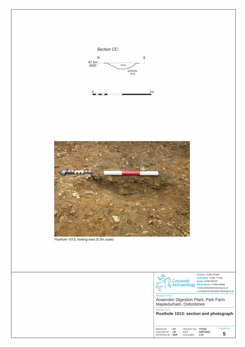
Posthole 1013, looking east (0.3m scale)
0 1m
1014
posthole1013
N S
Section CC
97.5mAOD
CotswoldArchaeology
PROJECT TITLE
FIGURE TITLE
FIGURE NO.
5
Anaerobic Digestion Plant, Park FarmMapledurham, Oxfordshire
Posthole 1013: section and photograph
PROJECT NO.DATESCALE@A4
DRAWN BYCHECKED BYAPPROVED BY
77024313/07/20151:20
AOLMDDR
Andover 01264 347630
Cirencester 01285 771022
Exeter 01392 826185
Milton Keynes 01908 564660
w www.cotswoldarchaeology.co.uk

Posthole 1015, looking east (0.3m scale)
1016
posthole1015
N S
Section DD
97.5mAOD
0 1m
CotswoldArchaeology
PROJECT TITLE
FIGURE TITLE
FIGURE NO.
6
Anaerobic Digestion Plant, Park FarmMapledurham, Oxfordshire
Posthole 1015: section and photograph
PROJECT NO.DATESCALE@A4
DRAWN BYCHECKED BYAPPROVED BY
77024313/07/20151:20
AOLMDDR
Andover 01264 347630
Cirencester 01285 771022
Exeter 01392 826185
Milton Keynes 01908 564660
w www.cotswoldarchaeology.co.uk

CotswoldArchaeology
PROJECT TITLE
FIGURE TITLE
FIGURE NO.
7 & 8
Anaerobic Digestion Plant, Park FarmMapledurham, Oxfordshire
Photographs
8
7
7 Working shot
8 Working shot
PROJECT NO.DATESCALE@A4
DRAWN BYCHECKED BYAPPROVED BY
77024313/07/2015N/A
AOLMDDR
Andover 01264 347630
Cirencester 01285 771022
Exeter 01392 826185
Milton Keynes 01908 564660
w www.cotswoldarchaeology.co.uk

16