an overview of the noah- distributed land surface model david j. gochis, wei yu, fei chen, kevin...
TRANSCRIPT

An Overview of the Noah-An Overview of the Noah-Distributed Land Surface ModelDistributed Land Surface Model
David J. Gochis, Wei Yu, Fei Chen, Kevin Manning
WRF Land Surface Modeling WorkshopSep. 13, 2005

Brief Rationale for Noah-Brief Rationale for Noah-DistributedDistributed
• Standard land surface parameterizations characterize exchanges of radiation, heat, mass and momentum between the land and atmosphere
• Historically, treatment of terrestrial hydrology has been simplified 1-d formulations
• With high resolution implementations/applications there is now a need to explicitly account for enhanced hydrological processes:Violating early assumptions…1. Surface runoff can not assumed to be “captured” by a stream channel2. Lateral transfers from one cell may form significant input to adjacent
cell

Brief Rationale for Noah-Brief Rationale for Noah-DistributedDistributed
• Standard land surface parameterizations characterize exchanges of radiation, heat, mass and momentum between the land and atmosphere
• Historically, treatment of terrestrial hydrology has been simplified 1-d formulations
• With high resolution implementations/applications there is now a need to explicitly account for enhanced hydrological processes:– Higher resolution capabilities land surface
heterogeneity– Earth systems-biogeochemcial cycling– Mitigation of “high-impact” weather events (e.g. floods)

OutlineOutline
• Brief overview of the Noah LSM
• Noah-distributed core features
• Implementation of Noah-distributed into the NCAR/HRLDAS framework
• Ongoing and planned upgrades to Noah-distributed


Community Noah Land Surface Model – Recent Enhancements
• Recent Enhancement of the Community Noah LSM (released in WRF V2.0, May 2004) ‘Noah-Unified’– “Nearly”-identical implementations of Noah LSM development
effort: NCAR, NCEP, U.S. Air Force Weather Agency, NASA, university community
– Fully modularized, F90 code conventions– Seasonal surface emissivity
• surface emissivity is introduced as function of landuse• Added surface emissivity in surface energy balance equation
for both snow and non-snow surfaces – Urban model improvements (the simple approach) such as
• Large roughness length • Low surface albedo• Large thermal capacity and thermal conductivity

Overland Flow Processes in Noah-RouterOverland Flow Processes in Noah-Router
• New Parameters: retention depth, New Parameters: retention depth, surface roughnesssurface roughness
• Ponded water in excess of retention Ponded water in excess of retention depth subject to overland flowdepth subject to overland flow
• Overland flow: fully-unsteady, Overland flow: fully-unsteady, explicit, finite-difference, 2-explicit, finite-difference, 2-dimensional diffusive wave dimensional diffusive wave (generally (generally applicable to length scales < 1km)applicable to length scales < 1km)
(NCAR Tech Note: Gochis and Chen, 2003)(NCAR Tech Note: Gochis and Chen, 2003)
2-Dimensional2-DimensionalDiffusive WaveDiffusive Wave
Overland Flow RoutingOverland Flow RoutingOgden, 1997Ogden, 1997
IF (Surface Head > Retention Depth) IF (Surface Head > Retention Depth) Route Water as Overland FlowRoute Water as Overland Flow
1, ,( ) /i j i jdhdx h h gsize
5 3( / ( ))x
sfx ABS sfx h dtq
dx
, 1 30i jsfx SOX dhdx E
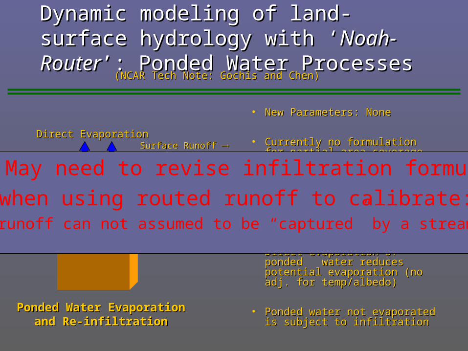
Dynamic modeling of land-surface hydrology Dynamic modeling of land-surface hydrology with ‘with ‘Noah-RouterNoah-Router’: Ponded Water Processes’: Ponded Water Processes
• New Parameters: NoneNew Parameters: None
• Currently no formulation for Currently no formulation for partial area coveragepartial area coverage
• Ponded water consists of: residual Ponded water consists of: residual of ‘infiltration excess’ from of ‘infiltration excess’ from previous time step and routed previous time step and routed surface watersurface water
• Direct evaporation of ponded Direct evaporation of ponded water reduces potential water reduces potential evaporation (no adj. for evaporation (no adj. for temp/albedo)temp/albedo)
• Ponded water not evaporated is Ponded water not evaporated is subject to infiltrationsubject to infiltration
(NCAR Tech Note: Gochis and Chen)(NCAR Tech Note: Gochis and Chen)
Ponded Water EvaporationPonded Water Evaporationand Re-infiltrationand Re-infiltration
Surface Runoff Surface Runoff Surface HeadSurface Head
Direct EvaporationDirect Evaporation
Re-infiltrationRe-infiltration
Issue: May need to revise infiltration formulation
when using routed runoff to calibrate:Surface runoff can not assumed to be “captured” by a stream channel

Subsurface Flow Routing Noah-RouterSubsurface Flow Routing Noah-Router(NCAR Tech Note: Gochis and Chen)(NCAR Tech Note: Gochis and Chen)
Saturated Subsurface RoutingSaturated Subsurface RoutingWigmosta et. al, 1994Wigmosta et. al, 1994
Surface Exfiltration fromSurface Exfiltration fromSaturated Soil ColumnsSaturated Soil Columns
Lateral Flow fromLateral Flow fromSaturated Soil LayersSaturated Soil Layers
• New Parameters: Lateral KNew Parameters: Lateral Ksatsat, n – , n –
exponential decay coefficientexponential decay coefficient• Critical initialization value: water table Critical initialization value: water table
depthdepth• 8-layer soil model (2m – depth, sealed 8-layer soil model (2m – depth, sealed
bottom boundary)bottom boundary)• Quasi steady-state saturated flow Quasi steady-state saturated flow
model, 2-d (x-,y-configuration)model, 2-d (x-,y-configuration)• Exfiltration from fully-saturated soil Exfiltration from fully-saturated soil
columnscolumns
, 1 30i jSOX dzdx E 1
nz
hhSOLDEP
( )tan
gsize LKSAT SOLDEP
n
xqsub hh

Noah-Distributed Core Features
• Present issues in treatment of subsurface routing:– Frozen soil adjustment to soil water
• Remove soil ice from total soil moisture and route only liquid component
– Update of conductivity as a function of soil temp/fraction of frozen soil
– Inclusion of variable depth soils

Subgrid RoutingSubgrid Routing
• Noah LSM is run at a variety of Noah LSM is run at a variety of grid spacingsgrid spacings
• Subsurface and overland flow Subsurface and overland flow routing need to be performed on a routing need to be performed on a terrain grid (< 1 km)terrain grid (< 1 km)
• Required fields are Required fields are aggregated/disaggregated using a aggregated/disaggregated using a simple averaging schemesimple averaging scheme
• Soil water, infiltration excess, Soil water, infiltration excess, routing parametersrouting parameters
• Can offer significant computational Can offer significant computational savings compared to full resolution savings compared to full resolution implementations of Noah LSMimplementations of Noah LSM
• Sacrifice detail in current Sacrifice detail in current formulationformulation
Noah land surface model grid
Routing Subgrids
AGGFACTR = 4

Noah-Distributed Core Features
• Subgrid disaggregation: proposed new method carrying over weighting factors between LSM model executions
• Eliminates the “loss” of distributed information between routing time-steps
Noah land surface model grid
Routing Subgrids

Noah-Distributed Software Features
• F90, up to date with recent version in HRLDAS• Routing routines (1-d and 2-d) are contained within a
single module (all agg./disagg. Routines will be included into routing module)
• Routing and sub-grid options are switch-activated though a namelist file
• Options to output sub-grid state and flux fields to WRF consistent netcdf files
• Basic Flow: LSM > Disagg. > Subsfc > Overland > Agg. > LSM > …
Outline
• Brief overview of the Noah LSM
• Noah-distributed core features
• Implementation of Noah-distributed into the NCAR/HRLDAS framework
• Ongoing and planned upgrades to Noah-distributed

NCAR-HRLDAS (High Res. Land Data Assim. System)
• Rationale and basics of HRLDAS:– Create globally-deployable variable resolution equilibrated land surface conditions for NWP initializations
• Current static & forcing data:Time
Variable Interval Dataset Grid Resolution Reference
Precipitation Hourly NEXRAD Stage IV 4 km Fulton et al, 1998
Surface Meteorology Hourly EDAS 40 km Rogers et al., 1995
Land Use Static USGS-24 Category 1 km Loveland et al., 1995
Greenness Fraction Monthly n/a 0.15 degree Gutman and Ignatov, 1998
Soil Classification Static STASGO-16 Category 1 km Miller and White, 1998
Overland Flow Roughness Coefficient Static n/a Mapped to Land Use Adapted from Vieux, 2001

HRLDAS• Recent tests over International H2O Project
(IHOP) domain• 18 month execution 1 Jan, 2001 – 30 Jun, 2002

Top Layer Soil Moisture (fraction):

Total Column Soil Moisture (mm):

Total Surface Evapotranspiration (mm):

Ponded Water Evaporation (mm):


Outline
• Brief overview of the Noah LSM
• Noah-distributed core features
• Implementation of Noah-distributed into the NCAR/HRLDAS framework
• Ongoing and planned upgrades to Noah-distributed
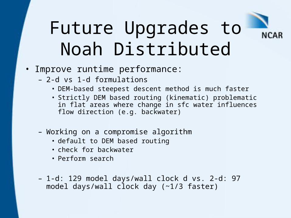
Future Upgrades to Noah Distributed
• Improve runtime performance:– 2-d vs 1-d formulations
• DEM-based steepest descent method is much faster• Strictly DEM based routing (kinematic) problematic in flat areas
where change in sfc water influences flow direction (e.g. backwater)
– Working on a compromise algorithm• default to DEM based routing • check for backwater• Perform search
– 1-d: 129 model days/wall clock d vs. 2-d: 97 model days/wall clock day (~1/3 faster)

Future Upgrades to Noah Distributed
• Complete parallelization• Couple to stream channel model (via
DESWAT project)• Develop better method to nudge/assimilate
groundwater and river/stream stage into modeling system
• Develop enhanced method to characterize stream-aquifer exchange
