an overview of the major commercial fisheries in the
TRANSCRIPT
An Overview of theMajor Commercial Fisheries
in the Unalaska Areathat may be Impacted by theM/V Selendang Ayu Oil Spill
Report toFisheries Work Group
April 15, 2005
Prepared By:
Nuka Research & Planning Group, LLC.

An Overview of Commercial Fisheries in Unalaska Area
2
P.O. Box 175Seldovia, Alaska 99663tel 907.234.7821fax [email protected]

An Overview of Commercial Fisheries in Unalaska Area
3
Table of Contents
Introduction ...................................................................................4
Overview of Major Commercial Fisheries............................................4
Commercial Ground Fisheries ...................................................5
Commercial Crab Fisheries .......................................................6
Other Commercial Fisheries......................................................7
Fishery Fact Sheets .................................................................7
Bering Sea/Aleutian Islands Pollock “A” Season..................................8
Gulf of Alaska Pollock ......................................................................9
Pacific Halibut IFQ Fishery ............................................................. 10
Spatial Distribution of Halibut Fishery ...................................... 13
Sablefish IFQ Fishery .................................................................... 16
Pacific Cod Hook and Line/Pot/Jig Gear ........................................... 19
Pacific Cod Trawl Gear................................................................... 20
Other Groundfish Species .............................................................. 21
Tanner (Bairdi) Crab Fishery .......................................................... 22
Bering Sea Snow (Opilio) Crab Fishery ............................................ 23
Commercial Salmon Fisheries......................................................... 24
Herring Food and Bait Fishery ........................................................ 24
Assessing Potential Commercial Fishery Impacts .............................. 26
References................................................................................... 31
Appendices .................................................................................. 33
Appendix A – Fisheries Fact Sheets
Makushin Tanner Crab Fishery
Unalaska Tanner Crab Fishery
Bering Sea Snow Crab Fishery
Bering Sea/Aleutian Islands Pacific Cod Fishery – Pot Gear
Bering Sea/Aleutian Islands Pollock Fishery “A” Season
Bering Sea/Aleutian Islands Pacific Cod Fishery – Trawl Gear
Appendix B – Acronyms

An Overview of Commercial Fisheries in Unalaska Area
4
An Overview of the Major Commercial Fisheriesin the Unalaska Area that may be Impacted by theM/V Selendang Ayu Oil Spill
Report toFisheries Work Group
By Nuka Research and Planning Group, LLCApril 15, 2005
Introduction
This report summarizes the major commercial fisheries that occur in and aroundthe M/V Selendang Ayu oil spill-impacted area between December 20, 2004 andMarch 31, 2005. This information was compiled at the request of the AlaskaDepartment of Environmental Conservation (NTP 1880032807B) to supportdecision-making during the M/V Selendang Ayu oil spill response.
Overview of Major Commercial Fisheries
Dutch Harbor is both the primary port in Unalaska and the largest commercialfishing port in the Pacific. According to the Alaska Department of Commerce,Community and Economic Development, the population of Dutch Harbor/Unalaskahas increased 40% in the past decade, from 3,089 in 1990 to 4,366 in 2003(DCCED, 2003). In addition to these permanent residents, the town supports anestimated additional population of between 6,000 and 10,000 seasonal residents,most of whom are associated with the commercial fishing industry and either workin town for less than 6 months per year or spend the majority of their timeoffshore on vessels.
Major commercial fisheries in Unalaska include a number of groundfish species, aswell as several major crab fisheries and a few smaller food and bait fisheries. Thebays and inshore waters of Unalaska Island support a number of commercially-significant groundfish species. Likewise, many vessels that fish in the Bering Sealand their catch at Unalaska or Dutch Harbor processors.
As of 2002, the Alaska Department of Fish and Game (ADFG) reported that theDutch Harbor district represented the greatest portion of the seafood harvest insouthwest Alaska, based both on poundage (48%) and ex-vessel value (44%).From 1998-2002, however, ex-vessel value paid by southwest Alaska processorsdeclined in all areas; at the same time, harvests increased by 14% based onpounds purchased by shore-based processors. In addition, since 1988 the DutchHarbor district has consistently had equal to or the highest number of processorsin the region (SWAMC, 2003).

An Overview of Commercial Fisheries in Unalaska Area
5
Commercial Ground Fisheries
Table 1 lists the major commercial fisheries that occur in the Unalaska area andwhich open to commercial fishing between 1/1/05 and 4/1/05. Additionalinformation on each of these fisheries is provided in subsequent sections of thisreport.
Table 1 – Commercial ground fishery seasons in Unalaska area
Fishery OpenDate
Close Date Location of Fishery(See Figure 2)
Estimated 2005Harvest Level
2004 Catch inUnalaska Area
Pollock“A”Season
1/20/05 3/25/05 Eastern Bering Sea,Aleutian Islands andBogoslof ExemptionArea; Fishing isconcentrated in 509,521, 513, 517 (eastof Unalaska, north ofUnimak pass) SeeFigure 1.
E. Bering Sea-1,478,500 mt;Aleutian Islands-19,000 mt;Bogoslof- 10 mt(quota is divided50% catcher;40% catcher/processor; 10%mothership)
Not a significant catcheffort in immediateUnalaska area, highvolume of catchprocessed in Unalaskaand catcher vesselstank down locally
Gulf ofAlaskaPollock
1/20/05 Area 610 closed3/12/05; Area620 closed3/20/05
Gulf of Alaskaregions 610, 620,630
15,865 mt In 2004, 22,148 mt(approx 44% of the50K mt quota) werelanded in area 610,including Unalaska
PacificHalibutIFQ
2/27/05 Nov. 2005 (atquota)
Bering Sea/AleutianIslands includinginshore waters
73.67 millionpounds (includessport &subsistence takeas well)
4.2 million poundslanded in Unalaska,622K landed inAkutan
Sablefish(blackcod) IFQ– federalwaters
2/27/05 Nov. 2005 (atquota)
Bering Sea/AleutianIslands includinginshore waters
6,000 mt 4.3 million poundslanded in Unalaska,258K landed inAkutan
Pacificcod -pot/linegear
1/1/05 Closed in phasesfrom 2/12/05 –3/10/05 basedon gear/vesselspecifications
Most of AleutianIslands/Bering Sea,including inshoreareas
2005 totalallowable catch(TAC) is 206,000mt (quota isshared with trawlfleet)
BS/AI total catch was113,881 mt
Pacificcod –trawlgear “A”season
1/20/05 Closed 3/13,then re-opened3/29 with 2,400mt remaining inquota for firstseasonalallowance
Bering Sea/AleutianIslands -concentrated East ofUnalaska Island
2005 TAC is206,000 mt(quota is sharedwith pot/linefleet)
BS/AI total catch was81,946 mt
BlackRockfishstatewatersfishery
1/1/05 There is an activefishery with a smallquota in Unalaskaarea; no boats arecurrently registeredin Unalaska
2005 TAC is35,000 lbs forUnalaska area

An Overview of Commercial Fisheries in Unalaska Area
6
Commercial Crab Fisheries
Table 2 lists commercial crab fisheries that occur near Unalaska Island and in theBering Sea/Eastern Aleutian Islands area, and which open to commercial fishingbetween 1/1/05 and 4/1/05. Additional information on each of these fisheries isprovided in subsequent sections of this report.
The Bering Sea red king crab fishery is not included in this table or this reportbecause the fishery did not occur during the emergency response phase of the oilspill and therefore was not a concern for response decision-making.
Table 2 – Commercial crab fisheries in Unalaska area
Fishery Open Date Close Date Location ofFishery (See
Figure 4)
Estimated 2005Harvest Level
2004 Catch inUnalaska Area
UnalaskaTanner(bairdi)crab
1/15/05 1/18/05 Unalaska Bay –ADFG statisticalarea 665335,665403.
Quota set at 35,304lbs
47,219 guidelineharvest level
MakushinTanner(bairdi)crab
Scheduledto open1/15/05 butarea closedtocommercialfishing byADFG12/27/04
Neveropened in2005
Makushin ADFGstatistical areas675332, 675331,665336
Quota set at171,453 lbs
87,891 guidelineharvest level
Bering Seasnow(opilio)crab
1/15/05 Quotareached at1/20/05.Processingcompleted inUnalaskaarea 2/6/05
Bering SeaDistrict West of166° Wlongitude.Fishery area is atsome distancefrom Unalaska,but large fleet(approximately170 vessels in2005) deliver livecrab to Unalaskaarea processors,using re-circulatingseawater tanks.
TAC set at 20.9million lbs
TAC set at 20.8million lbs
AleutianIslandsGolden(brown)king crab
8/15/04 8/29/04 eastof 174° Wlongitude,1/3/05 eastof 174° Wlongitude
Aleutian IslandsRegistration Area"O"
2005-2005:3.0 million lbseast of 174° Wlongitude (5.7million lbs total)

An Overview of Commercial Fisheries in Unalaska Area
7
Other Commercial Fisheries
In addition to the ground and crab fisheries summarized in Tables 1 and 2, severalsmaller commercial fisheries occur in the Unalaska area (Table 3).
Table 3. Other commercial fisheries in Unalaska area
Fishery Open Date CloseDate
Location of Fishery Estimated 2005Harvest Level
2004 Catch inUnalaska Area
Pink salmon No openerscheduled for2005
Unalaska area salmonstreams
Intermittentfishery, lastoccurred in1994 whentotal catch was49,428 fish
Herring foodand baitfishery
Not yetscheduled for2005—usuallyin July
Unimak, Akutan,Unalaska (UnalaskaBay), and Umnakdistricts
1,239 ton quota 1,258 tonsharvested(includinggillnet, seine,and poundfisheries)
Fishery Fact Sheets
To help the Unified Command and members of the public understand thecommercial fisheries at-risk of impacts from the Selendang Ayu oil spill, fisheryfact sheets were developed and posted to the Unified Command website for thefollowing fisheries:
• Makushin Tanner Crab Fishery
• Unalaska Tanner Crab Fishery
• Bering Sea Snow Crab Fishery
• Bering Sea/Aleutian Islands Pacific Cod Fishery – Pot Gear
• Bering Sea/Aleutian Islands Pollock Fishery “A” Season
• Bering Sea/Aleutian Islands Pacific Cod Fishery – Trawl Gear
Copies of these fishery fact sheets are included as Appendix A to this report.
An Overview of Commercial Fisheries in Unalaska Area
8
Bering Sea/Aleutian Islands Pollock “A” Season
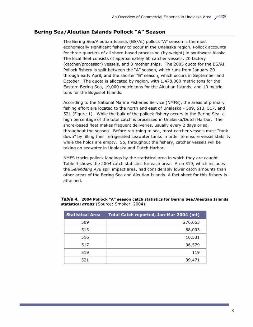
The Bering Sea/Aleutian Islands (BS/AI) pollock “A” season is the mosteconomically significant fishery to occur in the Unalaska region. Pollock accountsfor three-quarters of all shore-based processing (by weight) in southwest Alaska.The local fleet consists of approximately 60 catcher vessels, 20 factory(catcher/processor) vessels, and 3 mother ships. The 2005 quota for the BS/AIPollock fishery is split between the “A” season, which runs from January 20through early April, and the shorter “B” season, which occurs in September andOctober. The quota is allocated by region, with 1,478,000 metric tons for theEastern Bering Sea, 19,000 metric tons for the Aleutian Islands, and 10 metrictons for the Bogoslof Islands.
According to the National Marine Fisheries Service (NMFS), the areas of primaryfishing effort are located to the north and east of Unalaska - 509, 513, 517, and521 (Figure 1). While the bulk of the pollock fishery occurs in the Bering Sea, ahigh percentage of the total catch is processed in Unalaska/Dutch Harbor. Theshore-based fleet makes frequent deliveries, usually every 2 days or so,throughout the season. Before returning to sea, most catcher vessels must “tankdown” by filling their refrigerated seawater tanks in order to ensure vessel stabilitywhile the holds are empty. So, throughout the fishery, catcher vessels will betaking on seawater in Unalaska and Dutch Harbor.
NMFS tracks pollock landings by the statistical area in which they are caught.Table 4 shows the 2004 catch statistics for each area. Area 519, which includesthe Selendang Ayu spill impact area, had considerably lower catch amounts thanother areas of the Bering Sea and Aleutian Islands. A fact sheet for this fishery isattached.
Table 4. 2004 Pollock “A” season catch statistics for Bering Sea/Aleutian Islandsstatistical areas (Source: Smoker, 2004).
Statistical Area Total Catch reported, Jan-Mar 2004 (mt)
509 276,653
513 88,003
516 10,531
517 96,579
519 119
521 39,471

An Overview of Commercial Fisheries in Unalaska Area
9
Figure 1. Bering Sea/Aleutian Islands Pollock Fishery Open Area
Gulf of Alaska Pollock
The Gulf of Alaska pollock fishery is considerably smaller than the BeringSea/Aleutian Islands pollock fishery. In 2004, approximately 44% of the quotawas landed in area 610, which includes Unalaska (Figure 2). NMFS data indicatesthat the area to the southeast of Unalaska Island experiences significant fishingpressure by the Gulf of Alaska fleet. However, the total volume of pollock landedin this fishery is only a fraction of the larger Bering Sea/Aleutian Islands take(Table 3).
The Gulf of Alaska pollock fishery occurs in four seasonal openings over the courseof a calendar year, and is further subdivided by gear type (pot/hook line andtrawl). By regulation, this fishery is limited to vessels that deliver their catch at-shore; there is no catcher/processor or at-sea processing component. Pollockcaught in area 610 is landed in both Unalaska and Akutan. The first seasonalopening, for Area 610, occurred January 1 for pot/hook and line gear and January20 for trawl gear, and is now closed. Statistics for the 2004 fishery are includedin Table 5.

An Overview of Commercial Fisheries in Unalaska Area
10
Table 5. 2004 Gulf of Alaska pollock catch by reporting area (Source: Smoker, 2004)
Reporting Area Number of Vessels Total Catch Reported (mt)
610 25 22,148
620 47 20,659
630 36 7,658
Figure 2. Gulf of Alaska Pollock Fishery Management Areas
Pacific Halibut IFQ Fishery
The Pacific halibut fishery is managed under an individual fishing quota (IFQ)system where the TAC is allocated according to individual shares in the fishery.This system is meant to avoid disruptive changes in the composition of the fishingfleet and to maintain a broad distribution of quota shares among people who areactively involved in the fishery. The halibut fishery also includes communitydevelopment quotas (CDQ) which are specifically allocated to local coastalcommunities to preserve their access to the fishery resources.
The Pacific halibut fishery opening date was established by the International PacificHalibut Commission (IPHC) as February 27, 2005. The management areas forPacific halibut are also established by the IPHC, although NMFS tracks landing dataand actively manages many aspects of the fishery. Unlike many other Alaskafisheries, the commercial halibut season will occur over a period of several

An Overview of Commercial Fisheries in Unalaska Area
11
months, with catch levels starting out low and peaking in the summer months.According to NMFS daily landing data for 2004, halibut landings in Area 4A, whichincludes Unalaska (Figure 3), were lowest in March (NMFS, 2004a). Theygradually increased until they peaked in July, and then gradually decreasedthrough the end of the season in mid-November (Table 6). While there is limitedinformation available regarding specific locations where halibut was caught, a totalof 2.3 million pounds was landed in Unalaska/Dutch Harbor in 2004, accounting forapproximately 68% of the total landings for Area 4A (Table 7).
Figure 3. International Pacific Halibut Commission Reporting Areas (Source: IPHC, 2005)

An Overview of Commercial Fisheries in Unalaska Area
12
Table 6. Approximate monthly halibut landings for Area 4A, 2004 (Source: compiled fromdata in NMFS, 2004a. All values are approximate)
Month Estimated Pacific Halibut Landings
March 2004 (2/29/04-4/1/04) 53,000 lbs
April 2004 (4/2/04-5/4/04) 77,000 lbs
May 2004 (5/5/04-6/6/04) 360,000 lbs
June 2004 (6/7/04-7/9/04) 658,000 lbs
July 2004 (7/10/04-8/11/04) 950,000 lbs
August 2004 (8/12/04-9/13/04) 846,000 lbs
September 2004 (9/14/04-10/16/04) 378,000 lbs
October 2004 (10/17/04-11/18/04) 90,000 lbs
November 20041 (11/19/04-11/21/04)
0
Table 7. Total landings by port for Area 4A, 2004 (Source: NMFS, 2004b)
Port of Landing VesselLandings
Total Catch (pounds) Percent of AreaCatch
Adak N/A 1,026 .03%
Akutan 39 343,454 10.13%
Dutch Harbor/Unalaska 225 2,304,136 67.93%
Homer 10 349,300 10.3%
King Cove 7 136,075 4.01%
Kodiak N/A 39,710 1.17%
Sand Point 12 195,479 5.76%
Seward N/A 22,855 0.67%
Area Total 299 3,392,035 100%
1 Note that October 2004 catch statistics represent harvest through 11/18/04. The fishery closed on 11/21/04.

An Overview of Commercial Fisheries in Unalaska Area
13
Spatial Distribution of Halibut Fishery
Although the halibut landing statistics recorded by NMFS do not specify where thefish were caught, the inshore groundfish landing statistics for non-halibut speciesmay provide some insight into areas near the Selendang Ayu wreck that may beheavily fished by both the halibut and sablefish IFQ fisheries.
The non-halibut groundfish catch for the Unalaska Island area (Table 8) consistsprimarily of rockfish, skate, and cod species taken incidental to the halibut andsablefish IFQ fisheries in this area. By far, the area with the highest catch level fornon-halibut groundfish is 675333, which includes the federal waters immediatelyoutside of Makushin Bay, Skan Bay, and western Unalaska Island (see Figure 4 forreporting area locations). Since most of the non-halibut landings recorded inTable 8 reflect incidental harvest that occurs during halibut and sablefish targetfisheries, this may be considered as indirect evidence that area 675333 is the mostheavily fished area for halibut and sablefish near the spill impact zone.
The IPHC also tracks landing data, and provides information regarding the totalnumbers of vessels fishing and catch landed in IPHC statistical area 533167(Figure 5), which includes the spill impact area as well as areas south to UmnakPass and north to Koriga Point. Table 8 shows the total catch in pounds from1999-2003 for area 533167, by time of year. Table 9 shows the numbers ofvessels fishing in this area from 1999-2003, by time of year. Data for 2004 hadnot yet been compiled at the time of publication. Specific catch levels forMakushin Bay are not available due to confidentiality considerations (Blood, 2005).
Table 8. Non-halibut groundfish areas in Unalaska area, 2004 (Source: Morrison, 2005)
State Reporting Area Location 2004 Non-HalibutGroundfish Landings
(pounds)
665336 Makushin Bay 16,300
675304 Umnak Pass 48,000
675305 South of Skan Bay 16,000
675331 Mouth of Makushin Bay andnorth around Unalaska
Island
76,300
675333 Makushin/Skan/Unalaskaarea beyond state waters
754,300
675334 30,000
Total 940,900

An Overview of Commercial Fisheries in Unalaska Area
14
Figure 4 – ADFG Reporting Areas for Unalaska Island Area
Table 9. Halibut catch (net weight pounds) in IPHC Area 533167 by year,including estimated catch from Makushin Bay (Source: Blood, 2005)
Year Mar-May Jun-Aug Sep-Nov Grand Total
1999 65,685 411,571 65,183 542,439
2000 26,560 572,062 56,447 655,069
2001 55,235 523,625 78,475 657,335
2002 16,234 508,568 82,856 607,658
2003 51,942 504,912 91,411 648,265
GrandTotal
215,655 2,520,738 374,373 3,110,766

An Overview of Commercial Fisheries in Unalaska Area
15
Figure 5 – IPHC Statistical Area 533167 (Source: Blood, 2005)
Table 10. Numbers of distinct vessels fishing in IPHC Area 533167 by year,including estimated numbers of vessels in Makushin Bay (Source: Blood, 2005)
Year Mar-May Jun-Aug Sep-Nov
1999 9 24 6
2000 6 30 9
2001 6 41 11
2002 5 37 12
2003 6 37 15
360
370
533167
533166
540167 540166
533168
540168
168°0'0"W
168°0'0"W
167°30'0"W
167°30'0"W
167°0'0"W
167°0'0"W
166°30'0"W
166°30'0"W
53°30'0"N 53°30'0"N
54°0'0"N 54°0'0"N
Legend
ADF&G Areas of concern
IPHC Stat Areas
STAT_AREA
533167
Makushin Bay
Selendang Ayu area of concern in relation to IPHC Statistical Area 533167
0 10 205
Nautical Miles
UNALASKA ISLAND
Projection: Mercator IPHC 2005

An Overview of Commercial Fisheries in Unalaska Area
16
Sablefish IFQ Fishery
The sablefish (black cod) fishery is a federal fishery also managed under an IFQsystem. The 2005 season will run from late February through December. Geartypes include longline, bottom trawl, pot, and midwater trawls. Like the halibutfishery, the 2004 sablefish catch statistics show monthly catch rates increasing asthe season progressed, although sablefish landings peaked in May 2004, earlierthan halibut (Table 11).
Landing statistics on sablefish IFQ are recorded by region, as shown in Figure 6.Sablefish landed in Dutch Harbor/Unalaska may be caught almost anywhere in thestate (Table 12). Total sablefish landings for the Aleutian Islands area for 2004totaled just over 2 million pounds. Total landings for the Bering Sea totaledapproximately 1.16 million pounds (Table 13). Over 80% of the sablefish caughtin the Bering Sea and Aleutian Islands were landed in Dutch Harbor/Unalaska in2004 (Table 12).
In addition to the federal IFQ fishery, there is a separately-managed state watersfishery for sablefish. A guideline harvest level (GHL) is set by ADFG for statewaters in the Aleutian Islands management area, which includes the Unalaskaarea. This fishery does not open until May 15, 2005, and the GHL has not yetbeen set, but is usually established at or below 5% of the federal catch level forthe area.
In 2004, approximately 37,000 pounds of sablefish were caught in state waters inthe Unalaska and Umnak Island region. This amounts to approximately 8% of the480,000 GHL for the fishery in the Aleutian Islands. Of the harvest in theUnalaska area, approximately 27,000 pounds were caught in Umnak Pass,therefore the Umnak Pass area is presumed to have the highest concentration ofsablefish harvesting activity, although it is still a small fraction of the total AleutianIslands fishery. Because of its timing and location, this fishery is not included inTable 1 and was not a primary concern for response decision-making during theSelendang Ayu oil spill.

An Overview of Commercial Fisheries in Unalaska Area
17
Table 11. Monthly sablefish IFQ landings/year in pounds and percent of annual IFQ TAC(Source: NMFS, 2004c)
Month Landings Percent of TAC
March 2004 704,421 1.9%
April 2004 3,877,994 10.2%
May 2004 8,479,167 22.4%
June 2004 6,940,949 18.3%
July 2004 3,629,275 9.6%
August 2004 2,783,592 7.3%
September 2004 3,326,236 8.8%
October 2004 2,201,799 5.8%
November 2004 1,616,901 4.3%
December 2004 134,982 0.4%
Totals 33,695,316 88.8%
Figure 6. Sablefish IFQ Management Areas (Source: Muse, et al., 1996)

An Overview of Commercial Fisheries in Unalaska Area
18
Table 12. Sablefish IFQ landings in Dutch Harbor/Unalaska by management areawhere caught, 2004 (Source: Muse, et al., 1996)
Sablefish ManagementArea where caught
Dutch Harbor/UnalaskaLanding total for 2004
Percent ofArea Total
# Vessels Pounds
Aleutian Islands 68 1,739,384 83.45%
Bering Sea 120 940,596 81.22%
Central GOA 9 493,918 3.89%
Southeast Alaska N/A 23,175 0.28%
Western GOA 38 1,126,474 24%
West Yakutat N/A 67,300 1.38%
Table 13. Sablefish IFQ landings by management area, 2004 (Source: NMFS, 2004d)
SablefishManagement Area
VesselLandings
2004 Catch(pounds)
Percent of Total2004 Catch
Aleutian Islands 119 2,084,314 6.2%
Bering Sea 139 1,158,053 3.4%
Central GOA 650 12,713,109 37.7%
Southeast Alaska 701 8,172,370 24.3%
Western GOA 217 4,692,786 13.9%
West Yakutat 251 4,874,684 14.5%
Totals 2,077 33,695,316 100%
An Overview of Commercial Fisheries in Unalaska Area
19
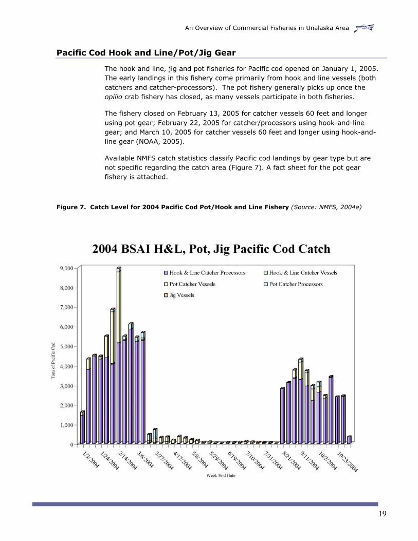
Pacific Cod Hook and Line/Pot/Jig Gear
The hook and line, jig and pot fisheries for Pacific cod opened on January 1, 2005.The early landings in this fishery come primarily from hook and line vessels (bothcatchers and catcher-processors). The pot fishery generally picks up once theopilio crab fishery has closed, as many vessels participate in both fisheries.
The fishery closed on February 13, 2005 for catcher vessels 60 feet and longerusing pot gear; February 22, 2005 for catcher/processors using hook-and-linegear; and March 10, 2005 for catcher vessels 60 feet and longer using hook-and-line gear (NOAA, 2005).
Available NMFS catch statistics classify Pacific cod landings by gear type but arenot specific regarding the catch area (Figure 7). A fact sheet for the pot gearfishery is attached.
Figure 7. Catch Level for 2004 Pacific Cod Pot/Hook and Line Fishery (Source: NMFS, 2004e)

An Overview of Commercial Fisheries in Unalaska Area
20
Pacific Cod Trawl Gear
The Bering Sea/Aleutian Islands Pacific cod trawl fishery opened on January 20,2005. Approximately 10-20 vessels in the Unalaska area participate in thisfishery. The Pacific cod trawlers are configured similarly to the pollock fleet, whichmeans that they use refrigerated seawater tanks to hold their catch. Like thepollock fleet, the Pacific cod fleet will “tank down” at the processor beforereturning back to the fishing grounds, which means it is vulnerable to oilcontamination during this process.
The Pacific cod trawl season usually ends in late March/early April. The remainingcatch (Figure 8) occurs as incidental catch during other fisheries. A fact sheet forthis fishery is attached.
Figure 8. Catch Levels for 2004 Pacific Cod Trawl Fishery (Source: NMFS, 2004e)

An Overview of Commercial Fisheries in Unalaska Area
21
Other Groundfish Species
Several other ground fisheries are open to commercial harvest in the EasternAleutian Islands, including Unalaska Island. These species include black rockfish,yellowfin sole, rock sole, flathead sole and several other species that are primarilylanded as bycatch to other target fisheries (e.g. Atka mackerel, Pacific oceanperch, other rockfish species).
There is a small state fishery for black rockfish in the Unalaska area. The fisheryopened on January 1, and according to ADFG, there are no vessels registered inthis fishery yet for 2005. None of the 35,000 GHL was landed in the Unalaskaregion in 2003. 2004 statistics are not yet available. Statistics from previousyears are confidential due to the limited number of vessels that participated in thefishery.
There are several other federal flatfish fisheries that occur in the Bering Sea. Theyellowfin sole fishery includes as many as 21 catch/processors and is a staplefishery for the large, high-volume vessels. The fishery is managed in threeseasonal disbursements which are usually determined by halibut mortality caps.The rock sole and flathead sole fisheries are similar in nature, although those fishare higher value and catch levels are usually lower. As Table 14 shows, theseflathead fisheries occur well north of Unalaska Island (See Figure 1 for map ofreporting areas). Catch levels in Area 519, which includes Unalaska, were quitelow. The yellowfin sole fishery was closed to directed fishing on March 16, 2005 toavoid exceeding the 2005 bycatch allowance of red king crab.
Table 14. Flatfish catch levels in Bering Sea/Aleutian Islands, 2004 (Source: Smoker,2004)
Reporting Area Total 2004 landings yellowfin sole, rock sole,flathead sole, and “other” flatfish targets
509 40,209 mt
521 36,808 mt
514 30,732 mt
513 30,501 mt
516 14,835 mt
524 11,005 mt
517 4,068 mt
519 801 mt

An Overview of Commercial Fisheries in Unalaska Area
22
Tanner (Bairdi) Crab Fishery
The Tanner crab fishery occurs in two areas of the state waters around UnalaskaIsland. The Unalaska Bay component of the fishery occurs in ADFG statisticalareas 665335 and 665403 (Figure 9). The Makushin area component of thefishery occurs in ADFG statistical areas 675332, 675331, and 665336 (Figure 9).Both are managed by ADFG with the same opening and closure dates, althoughdistinct quotas are set for the Unalaska Bay and Makushin Bay areas. In 2005, thequota for Unalaska Bay was set at 35,304 lbs and the Makushin quota at 171,453lbs.
On December 27, 2004, the Alaska Department of Fish and Game closed theMakushin component of the Tanner crab fishery as part of the commercial fisheriesclosure in the Selendang Ayu spill impact area (ADFG, 2004). The Unalaska Bayfishery proceeded as scheduled; quota was caught in approximately 3 days. Theregulatory closure date for both fisheries is March 31, 2005. A fact sheet for theUnalaska Tanner crab fishery is attached.
Figure 9. Tanner Crab Fishery Locations near Unalaska Island

An Overview of Commercial Fisheries in Unalaska Area
23
Bering Sea Snow (Opilio) Crab Fishery
The Bering Sea District of the Bering Sea snow crab fishery is located to the northand east of Unalaska Island (Figure 10). Shore-based processors are located at St.Paul Island, Akutan, Dutch Harbor, and King Cove. Catcher-processors and at-seaprocessors are also used, some of which anchor in Unalaska Bay. This is a state-run fishery.
A total of 171 vessels was permitted to register by the December 27, 2004deadline, with a guideline harvest level of 20.9 million pounds. Of the total, 1.57million pounds are available to the CDQ fishery. Vessels of 125 feet or less had alimit of 70 pots, while longer vessels had a limit of 90 pots.
The 2004 guideline harvest level (GHL) was 20.8 million pounds, with the actualcatch at 23.9 million pounds. Last year, 189 vessels participated. (Hughes, 2004)
The season opened on January 15, 2005 with no restrictions resulting from theSelendang Ayu spill. Unified Command issued an advisory to the Bering Sea snowcrab fleet recommending vessels obtain the latest water quality sampling datafrom processors prior to returning to port with re-circulating seawater holds. DutchHarbor vessels were given the option of landing in Beaver Inlet and associatedbays prior to unloading. The 2005 fishery closed on January 20, 2005. A fact sheetfor this fishery is attached.
Figure 10. Bering Sea Snow Crab Fishery Locations near Unalaska Island

An Overview of Commercial Fisheries in Unalaska Area
24
Commercial Salmon Fisheries
Commercial fishing for salmon in the Unalaska area is extremely limited. There isan intermittent commercial fishery that targets pink salmon, depending on thestrength of the return (Schwarz, 2002). Over the past 11 years, commercialsalmon fisheries in Unalaska Bay have occurred during 2 years. During 1990 and1994, when fisheries occurred, the harvests were 38,320 and 49,430 pink salmon,respectively (Table 15).
Table 15. Unalaska Bay commercial salmon harvest in numbers of fish,1990-2001 (Source: Schwarz, 2002)
Year Chinook Sockeye Coho Pink Chum
1990 0 81 3 38,323 188
1991 0 0 0 0 0
1992 0 0 0 0 0
1993 0 0 0 0 0
1994 0 41 0 49,428 138
1995 0 0 0 0 0
1996 0 0 0 0 0
1997 0 0 0 0 0
1998 0 0 0 0 0
1999 0 0 0 0 0
2000 0 0 0 0 0
2001 0 0 0 0 0
0 11 0 7,977 301991-2000Average
Herring Food and Bait Fishery
The Dutch Harbor herring food and bait fishery is managed as part of the Togiakherring roe fishery, with the Dutch Harbor fishery allowed 7% of the TAC.Management of the fishery is determined by pre-season spawning biomassprojections, which are based on both aerial surveys and age-structured analysis.
The herring food and bait fishery is allowed only in the eastern Aleutian Islandssection of the Alaska Peninsula-Aleutian Islands Management Area, which includesUnalaska, Akutan, Unimak, Umnak, and the newly-designated Adak district. In2004, the fishery took place entirely within Unalaska Bay (see Figure 11). Thetotal ex-vessel value of the 2004 fishery was $375,000; it was characterized as"slow," with several unsuccessful sets and relatively small schools of herring in thearea (Duesterloh, 2004).

An Overview of Commercial Fisheries in Unalaska Area
25
Figure 11. Area Open to Fishing in 2004 Dutch Harbor Herring Food and Bait Fishery(Source: Duesterloh, 2004)
UnalaskaIsland
Makushin Bay
Eider Pt.
Captain's Bay
Cape Cheerful
Unalaska B
ay
Dutch Harbor
Priest Rock
Beaver In
let
Unalaska
2004 Fishing Area
*
Area open to fishingBERING SEA
UnalaskaIsland
Makushin Bay
Eider Pt.
Captain's Bay
Cape Cheerful
Unalaska B
ay
Dutch Harbor
Priest Rock
Beaver In
let
Unalaska
2004 Fishing Area
0 5
miles10
AREA OF DETAIL
Alaska
Bering Sea
Broad Bay
Table 16. Dutch Harbor herring food and bait fishery allocations and commercialharvests for all gear types, in short tons 2001-2004 (Source: Duesterloh, 2004)
2001 2002 2003 2004
Preseason Togiak spawningbiomass
119,818 120,196 126,213 143,124
Allocation 1,572 1,578 1,662 1,899
Harvest 1,439 2,751 1,487 1,258

An Overview of Commercial Fisheries in Unalaska Area
26
Table 17. Dutch Harbor herring food and bait fishery harvests (in short tons) and effortby gear type, 2001-2004 (Source: Duesterloh, 2004)
Fishery 2001 2002 2003 2004
Gillnet Allocation 110 110 116 266
Harvest 107 134 108 216
Vessels 6 13 13 7
Landings 25 37 23 37
Days fished 9 16 5 12
Seine Allocation 1,462 1,468 1,546 1,533
Harvest 1,332 2,617 1,379 1,035
Vessels 14 16 14 (a) 3 (b)
Landings 16 14 16 20
Days fished 2 1 2 9
Seine Pound Allocation 100
Harvest 6
Vessels 1
Landings 1
Days fished 1
(a) 14 permit holders used 6 vessels in a cooperative fishery(b) 16 permit holders used 1 vessel in a cooperative fishery
Assessing Potential Commercial Fishery Impacts
There are multiple potential exposure pathways through which commercial fishspecies may be exposed to spilled oil. The major commercial fish species at risk ofoil impacts from the Selendang Ayu include snow and Tanner crab, pollock, Pacificcod, halibut, and sablefish. Other important fishery species, such as herring andsalmon, are also vulnerable to oil impacts, however the fisheries themselves areless economically significant. Many of the at-risk commercial fishery species arealso utilized for sport and subsistence; however, for the purposes of this report,recreational and subsistence use have not been considered.
With the exception of pollock, the major commercial finfish species considered inthis report are all ground fish, which means they live the majority of their adult lifeon the seafloor. Crab are also benthic organisms, while pollock are a mid-waterfish species. For all commercial fish species discussed herein, contact with wholeoil is a primary pathway of exposure in the marine environment. All fish speciesmay also absorb dissolved phase oil that is present in the water column.

An Overview of Commercial Fisheries in Unalaska Area
27
Crab catcher vessels in both the Tanner and snow crab fisheries utilize live holdtanks, which continually pump seawater to keep the crab alive until they aredelivered at processors. This configuration makes this fishery especiallyvulnerable to whole oil in the water column, as it may enter the seawatercirculation systems on these vessels and contaminate the holds. Since the pollockand Pacific cod fleets both utilize refrigerated sea water tanks, those fisheries arevulnerable to oil impacts if floating oil enters the seawater intake of catchervessels. Whole or dissolved phase oil in the water column may also contaminatethe seawater intakes of Unalaska seafood processing plants.
Another exposure pathway is through contamination of pot fishing gear used in theTanner crab and Pacific cod fisheries in Unalaska Bay and other inshore waters.Contact with contaminated sediments is also a potential exposure pathway forgroundfish and crabs. These organisms may be exposed to contaminatedsediments that are re-suspended into the water column (especially in areasadjacent to oiled beaches and after storms), or they may have other forms ofdirect contact with contaminated sediments, including ingestion.
Table 16 describes potential vulnerabilities for each of the fisheries considered inthis report.
Table 16. Potential vulnerabilities of each fishery to spill impacts
Fishery Proximity to SpillImpact Area
Potential Vulnerabilities
BS/AI Pollock Fishery concentratedin areas east ofUnalaska, north ofUnimak Pass.
• Fleet that delivers to Unalaska processorswill tank down in Bay – floating oil in baycould enter RSW tank.
• Large, mid-water trawling nets are used tocatch fish and could also ensnare floatingtarballs. However, fishing area is distantfrom spill site and no evidence to datesuggests that tarball distribution is thatwidespread.
• Potential for floating oil in Unalaska Bay toenter water intake at processing plants.
GOA Pollock Occurs in Gulf ofAlaska, immediatelysouth of Aleutianchain. No oil hasbeen encountered inthe GOA to date.
• Fleet that delivers to Unalaska processorswill tank down in Bay – floating oil in baycould enter RSW tank.
• Large, mid-water trawling nets are used tocatch fish and could also ensnare floatingtarballs. However, there is no evidence todate of tarballs in the GOA or areas south ofUnalaska Island.
• Potential for floating oil in Unalaska Bay toenter water intake at processing plants.

An Overview of Commercial Fisheries in Unalaska Area
28
Fishery Proximity to SpillImpact Area
Potential Vulnerabilities
Pacific Cod –Pot/Line
Commercial fishingoccurs in inshorewaters, includingMakushin closedarea, spill impactarea, Unalaska Bay,and adjacent areas.
• Fleet that delivers to Unalaska processorsmay tank down in Bay – floating oil in baycould enter RSW tank.
• Fishery includes areas where floating oil hasbeen encountered and areas adjacent toknown oiled beaches.
• Fish are vulnerable to oil through ingestion,direct contact, and absorption of dissolvedphase oil.
• Fishing gear vulnerable to contamination.
• Potential for floating oil in Unalaska Bay toenter water intake at processing plants.
Pacific Cod -Trawl
Fishery concentratedin areas east ofUnalaska, north ofUnimak Pass.
• Fleet that delivers to Unalaska processorswill tank down in Bay – floating oil in baycould enter RSW tank.
• Fish are vulnerable to oil through ingestion,direct contact, and absorption of dissolvedphase oil.
• Fishing gear vulnerable to contamination.
• Fishing area further offshore than pot/linefleet.
• Potential for floating oil in Unalaska Bay toenter water intake at processing plants.
Halibut IFQ Commercial fishingoccurs in federal &inshore waters,including Makushinclosed area, spillimpact area,Unalaska Bay, andadjacent areas.Large percentage ofannual harvest islanded in DutchHarbor/Unalaska.Bycatch landingrecords indicate thatthe area just outsidestate waters adjacentto the spill is heavilyfished.
• Fishery includes areas where floating oil hasbeen encountered and areas adjacent toknown oiled beaches.
• Fish are vulnerable to oil through ingestion,direct contact, and absorption of dissolvedphase oil.
• Fishing gear vulnerable to contamination.
• Fishery occurs over several months andseasons – lengthened period of potentialexposure.
• Potential for floating oil in Unalaska Bay toenter water intake at processing plants.

An Overview of Commercial Fisheries in Unalaska Area
29
Fishery Proximity to SpillImpact Area
Potential Vulnerabilities
Sablefish IFQ& StateFishery
Commercial fishingopen in federal andstate waters,including Makushinclosed area, spillimpact area,Unalaska Bay, andUmnak Pass.Bycatch landingrecords for federalfishery indicate thatthe area just outsidestate waters adjacentto the spill may beheavily fished. Mostinshore fishing inUmnak Pass andwest.
• Fishery includes areas where floating oil hasbeen encountered and areas adjacent toknown oiled beaches.
• Fish are vulnerable to oil through ingestion,direct contact, and absorption of dissolvedphase oil.
• Fishing gear vulnerable to contamination.
• Fishery occurs over several months andseasons – lengthened period of potentialexposure.
• Potential for floating oil in Unalaska Bay toenter water intake at processing plants.
Makushin BayTanner Crab
Fishery within spillimpact area. Closedfor 2005 season.
• None due to closure.
Unalaska BayTanner Crab
Commercial fishing instate waters inUnalaska Bay
• Floating oil has been encountered in fisheryarea (Unalaska) Bay and tar balls and tarpatties observed on area beaches.
• Crab are vulnerable to oil through ingestion,direct contact, and absorption of dissolvedphase oil.
• Fishing gear vulnerable to contamination.
• Potential for floating oil in Unalaska Bay toenter seawater intakes on vessels that userefrigerated or re-circulating tanks.
• Potential for floating oil in Unalaska Bay toenter water intake at processing plants.
Bering SeaSnow Crab
Commercial fisheryin Bering Sea, atsome distance fromUnalaska. Catchervessels deliver toshore-based andfloating processors inUnalaska Bay andAkutan.
• Fleet utilizes re-circulating seawater tanksthat constantly pump water to keep crabalive. Floating oil may enter vessel seawatersystem and contaminate catch.
• Because of the way the fishery is structured,vessels must wait up to a week for anopportunity to deliver catch to Unalaska Bayprocessors. Vessels wait at anchor in thebay and continually pump seawater,lengthening their time of potential exposure.
• Crab are vulnerable to oil through ingestion,direct contact, and absorption of dissolvedphase oil.

An Overview of Commercial Fisheries in Unalaska Area
30
Fishery Proximity to SpillImpact Area
Potential Vulnerabilities
direct contact, and absorption of dissolvedphase oil.
• Fishing gear vulnerable to contamination.
• Potential for floating oil in Unalaska Bay toenter water intake at processing plants.
Golden KingCrab
Commercial fisheryin Bering Sea, atsome distance fromUnalaska. Catchervessels deliver toshore-based andfloating processors inUnalaska Bay andAkutan.
• Fishery closed in early January and catchlevels low during the time of the oil spill.
• Crab are vulnerable to oil through ingestion,direct contact, and absorption of dissolvedphase oil.
• Fishing gear vulnerable to contamination.
• Potential for floating oil to enter seawaterintakes on vessels.
• Potential for floating oil in Unalaska Bay toenter water intake at processing plants.
Salmon No commercialfishery in 2005.
• Not applicable.
Herring Occurs in UnalaskaBay
• Fishery includes areas where floating oil hasbeen encountered and areas adjacent toknown oiled beaches.
• Fish are vulnerable to oil through ingestion,direct contact, and absorption of dissolvedphase oil.
• Fishing gear vulnerable to contamination.
• Potential for floating oil in Unalaska Bay toenter water intake at processing plants.

An Overview of Commercial Fisheries in Unalaska Area
31
References
Alaska Department of Fish and Game (ADFG), 2004. "ADF&G Announces FisheryClosures Surrounding the Selendang Ayu Oil Spill," December 27.http://www.state.ak.us/dec/spar/perp/response/sum_fy05/041207201/041207201_closure.pdf
Blood, C. 2005 Personal communications with author. February 8.
Duesterloh, Switgard, 2004. Memorandum to Jim McCullough, Regional FinfishManagement Supervisor, Division of Commercial Fisheries, September 21.
Failor-Rounds, B. 2004. Bering Sea-Aleutian Islands Area State-WatersGroundfish Fisheries and Groundfish Harvest from Parallel Seasons in 2003.Regional Information Report No. 4K04-45. Alaska Department of Fish and Game,Division of Commercial Fisheries. Kodiak, Alaska. 42 pp.
Failor-Rounds, B. 2005. Alaska Department of Fish and Game. Unalaska, Alaska.Personal communications with author. February 2.
International Pacific Halibut Commission (IPHC). 2005. IPHC Regulatory Areas.http://www.iphc.washington.edu/halcom/commerc/regmap.htm
Morrison, R. 2005. National Marine Fisheries Service. Juneau, Alaska. Personalcommunications with author. January 1-31.
Muse, B., K. Schelle, E. Dinneford, and K. Iverson. 1996. Changes under Alaska’sSablefish IFQ Program, 1995. Alaska Commercial Fisheries Entry Commission.CFEC Report No. 96-11N. Juneau, Alaska.
National Marine Fisheries Service (NMFS). 2004a. Daily Halibut IFQ Landings byArea of Harvest. Juneau, Alaska. http://www.fakr.noaa.gov/ram/04ifqhdaily.htm
National Marine Fisheries Service. 2004b. Individual Fishing Quota (IFQ) HalibutHarvest by Port of Landing. Juneau, Alaska.http://www.fakr.noaa.gov/ram/04ifqporth.htm
National Marine Fisheries Service. 2004c. Monthly Sablefish IFQ Landings by Yearin Pounds and Percent of Annual IFQ TAC. Juneau, Alaska.http://www.fakr.noaa.gov/ram/04ifqsmonthly.htm
National Marine Fisheries Service. 2004d. Individual Fishing Quota (IFQ)Allocations and Landings. Juneau, Alaska.http://www.fakr.noaa.gov/ram/04ifqland.htm
National Marine Fisheries Service. 2004e. Alaska Region Inseason ManagementReport. December.http://www.fakr.noaa.gov/sustainablefisheries/inseason/2004report.pdf
National Marine Fisheries Service. 2005. Fishery summary as of January 27,2005. Alaska Region Inseason Management.

An Overview of Commercial Fisheries in Unalaska Area
32
http://www.fakr.noaa.gov/sustainablefisheries/reports/outlook.txt
National Oceanic and Atmospheric Administration (NOAA). 2005. SustainableFisheries 2005 Information Bulletins.http://www.fakr.noaa.gov/infobulletins/default.htm
Schwarz, L. J. 2002. Area Management Report for the Recreational Fisheries of theKodiak and Alaska Peninsula/Aleutian Islands Regulatory Areas, 1999 and 2000.Alaska Department of Fish and Game, Fishery Management Report No. 02-02,Anchorage.
Smoker, A. 2004. National Marine Fisheries Service. Juneau, Alaska. Personalcommunications with the author. December 27-29.
Southwest Alaska Municipal Conference (SWAMC), 2005. Chapter 9.0, SouthwestAlaska Regional Economy. Pp. 91-118. http://www.swamc.org/economics/09-SWRegionalEconomy.pdf

An Overview of Commercial Fisheries in Unalaska Area
33
Appendix A: Fishery Fact Sheets
• Makushin Tanner Crab Fishery
• Unalaska Tanner Crab Fishery
• Bering Sea Snow Crab Fishery
• Bering Sea/Aleutian Islands Pacific Cod Fishery – Pot Gear
• Bering Sea/Aleutian Islands Pollock Fishery “A” Season
• Bering Sea/Aleutian Islands Pacific Cod Fishery – Trawl Gear

M/V Selendang Ayu Oil Spill Response – Fishery Fact Sheet #1 – Makushin Tanner Crab
Makushin Tanner Crab Fishery
Fish Species
Tanner Crab {Chionoecetes bairdi}
Location of Fishery
Makushin ADFG statistical areas 675332, 675331, 665336
Harvest Level Quota 171,453 lbs Number of Vessels
55 (final)
Registration Deadline
12/27/04
Sea water Circulation
Yes – sea water is continuously circulated through live tanks
Open Date January 15, 2005 - Noon Management Agency
Alaska Department of Fish and Game (ADFG)
Close date At quota, no later than 3/31/05
Gear Type Crab Pots
Processors Shore-based only - Dutch Harbor/Unalaska
Transit Route
Nearshore transit northeast around Unalaska Island to Unalaska Bay
2005 Fishery Status
Closed until further notice – 12/27/04
For more information contact ADFG Commercial Fisheries Area Management Biologist, Forrest Bowers (907) 581-1239,or visit http://www.state.ak.us/dec/spar/perp/response/sum_fy05/041207201/041207201_closure.pdf
Rev. 1/5/2005 Page 1 of 1

M/V Selendang Ayu Oil Spill Response – Fishery Fact Sheet #2 – Unalaska Bay Tanner Crab
Unalaska Tanner Crab Fishery
Fish Species
Tanner Crab {Chionoecetes bairdi}
Location of Fishery
Unalaska Bay – ADFG statistical area 665335, 665403.
Harvest Level Quota 35,304 lbs Number of Vessels
55 (includes Makushin area Tanner Crab fishery)
Registration Deadline
12/27/04 Sea water Circulation
Live hold tanks in most vessels. A few use dry holds because of proximity to processors.
Open Date January 15, 2005 - Noon Management Agency
Alaska Department of Fish and Game (ADFG)
Close date Quota was reached 1/18/05
Gear Type Crab pots
Processors Shore-based only - Dutch Harbor/Unalaska
Transit Route
All of Unalaska Bay may be transited.
Other Vessel size limited 58 feet (from Cape Cheerful to Priest Rock).
2005 Fishery Status
Unaffected by Selendang Ayu fishery closures
For more information contact ADFG Commercial Fisheries Area Management Biologist, Forrest Bowers (907) 581-1239or visit http://www.cf.adfg.state.ak.us/region4/news/2004/nr1104a04.pdf
Rev. 4/15/2005 Page 1 of 1

M/V Selendang Ayu Oil Spill Response – Fishery Fact Sheet #3 –Bering Sea Snow Crab
Bering Sea Snow Crab Fishery
Fish Species
Chionoecetes opilio Location of Fishery
Bering Sea District west of 166° W longitude
Harvest Level 20.9 million pounds Number of Vessels
171
Registration 12/27/04 Sea water Circulation
Yes, live hold
Open Date 1/15/05 Management Agency
ADFG
Close date 1/20/05 (quota met) Gear Type Crab pots Shore-Based Processors
Unalaska, Akutan, King Cove, Kodiak & St. Paul
At-sea Processors
Catcher-processors and at-sea processors; some anchor in Unalaska bay.
2005 Fishery Status
Unaffected by Selendang Ayu closures. Processing completed in Unalaska 2/6/05.
For more information contact ADFG Commercial Fisheries Area Management Biologist, Forrest Bowers (907) 581-1239 or visit http://www.cf.adfg.state.ak.us/region4/news/2004/nr091604.pdf.
Rev. 4/15/2005 Page 1 of 1

M/V Selendang Ayu Oil Spill Response – Fishery Fact Sheet #4 – BS/AI Pacific Cod Pot
Bering Sea/Aleutians Pacific Cod Fishery – Pot Gear
Fish Species
Gadus macrocephalus Location of Fishery
Bering Sea/Aleutian Islands, including Bogoslof exemption area
Harvest Level 2005 TAC is 206,000 mt (quota is shared with trawl fleet)
Number of Vessels
35-50
Registration Federal permit required http://www.fakr.noaa.gov/ram/ffpfpp.htm
Sea water Circulation
RSW. Some boats use ice in hold instead of seawater.
Open Date 1/1/05 but fishing doesn’t usually start in earnest until close of snow crab
Management Agency
NMFS
Close date Closed in phases from 2/12/05 – 3/10/05 based on gear/vessel specifications
Gear Type Pot, hook & line, trawl
Processors Dutch Harbor, Akutan and at-sea
Transit Route
Dutch Harbor east to fishing grounds.
2005 Fishery Status
Closures to inshore waters - Skan & Makushin Bays by ADFG 12/27/04
For more information contact NMFS Alaska Groundfish Management - Andy Smoker, (907) 586-7210 or Rance Morrison (907) 581-2062, or visit http://www.fakr.noaa.gov/sustainablefisheries/default.htm.
Rev. 4/15/2005 Page 1 of 1

M/V Selendang Ayu Oil Spill Response – Fishery Fact Sheet #5 – EBS/AI Pollock
Bering Sea/Aleutian Islands Pollock Fishery “A Season”
Fish Species
Theragra chalcogramma Location of Fishery
EBS & AI. Fishing is concentrated north & west of Unimak Island
Harvest Level EBS -1,478,500 mt AI – 19,000 mt Bogoslof – 10 mt Quota split between A & B seasons
Number of Vessels
Approx. 60 catcher vessels, 20 factory vessels & 3 mother ships; quota is divided 50% catcher, 40% catcher/processor & 10% mothership
Registration Federal permit required http://www.fakr.noaa.gov/ram/ffpfpp.htm
Sea water Circulation
Refrigerated Sea Water (RSW), no live hold
Open Date 1/20/05 Management Agency
NMFS
Close date 3/25/05 Gear Type Trawl Shore-based Processors
Dutch Harbor, King Cove, Akutan, Beaver Inlet; shore-based fleet comes ashore every 2 days or so
At-sea or catcher-processors
Catcher-processors, floating processors & mother ships
Other Sea Lion conservation areas (SCA) affect catch limits in some areas.
2005 Fishery Status
Closures to inshore waters - Skan & Makushin Bays by ADFG 12/27/04
For more information contact NMFS Alaska Groundfish Management - Andy Smoker, (907) 586-7210 or Rance Morrison (907) 581-2062, or visit http://www.fakr.noaa.gov/sustainablefisheries/default.htm.
Rev. 4/15/2005 Page 1 of 1

M/V Selendang Ayu Oil Spill Response – Fishery Fact Sheet # 6 – BS/AI Pacific Cod Trawl
Rev. 4/15/2005 Page 1 of 1
Bering Sea/Aleutian Islands Pacific Cod Fishery - Trawl
Fish Species Gadus macrocephalus Location ofFishery
Bering Sea/Aleutian Islands –fishery concentrated east ofUnalaska
Harvest Level 2005 TAC is 206,000 mt(quota is shared withpot/line fishery)
Number ofVessels
10-20
Registration Federal permit requiredhttp://www.fakr.noaa.gov/ram/ffpfpp.htm
Sea waterCirculation
RSW
Open Date A Season - 1/20/05B Season – 9/1/2005
ManagementAgency
NMFS
Close date A Season closed 3/13,then re-opened 3/29 with2,400 mt remaining inquota for first seasonalallowance
Gear Type trawl
Processors Primarily at-sea, catcher-processors
2005 FisheryStatus
Closures to inshore waters - Skan& Makushin Bays by ADFG12/27/04
For more information contact NMFS Alaska Groundfish Management - Andy Smoker, (907) 586-7210or Rance Morrison (907) 581-2062, or visit http://www.fakr.noaa.gov/sustainablefisheries/default.htm.

An Overview of Commercial Fisheries in Unalaska Area
34

An Overview of Commercial Fisheries in Unalaska Area
35
Appendix B: AcronymsADFG Alaska Department of Fish and Game
AI Aleutian Islands
BS/AI Bering Sea/Aleutian Islands
CDQ Community Development Quota
DCCED Department of Commerce, Community and Economic Development
DEC Department of Environmental Conservation
EBS Eastern Bering Sea
GHL Guideline Harvest Level
GOA Gulf of Alaska
H&L Hook and line
IFQ Individual Fishing Quota
IPHC International Pacific Halibut Commission
NTP Notice to Proceed (for DEC Term Contractors)
Mt Metric Ton
M/V Motor Vessel
NMFS National Marine Fisheries Service
NOAA National Oceanic and Atmospheric Administration
RSW Refrigerated Seawater
SCA Sea lion Conservation Area
SWAMC Southwest Alaska Municipal Conference
TAC Total Allowable Catch
