an open-source 3d solar radiation model integrated with a ... · an open-source 3d solar radiation...
TRANSCRIPT

lable at ScienceDirect
Environmental Modelling & Software 64 (2015) 94e101
Contents lists avai
Environmental Modelling & Software
journal homepage: www.elsevier .com/locate/envsoft
Short communication
An open-source 3D solar radiation model integrated with a 3DGeographic Information System
Jianming Liang a, b, Jianhua Gong a, b, *, Jieping Zhou a, b, Abdoul Nasser Ibrahim a, b,Ming Li c
a State Key Laboratory of Remote Sensing Science, Institute of Remote Sensing and Digital Earth, Chinese Academy of Sciences, P.O. Box 9718, Beijing 100101,Chinab Zhejiang-CAS Application Center for Geoinformatics, Zhejiang 314100, Chinac Jiashan Metrological Bureau, Zhejiang 314100, China
a r t i c l e i n f o
Article history:Received 9 May 2014Received in revised form13 November 2014Accepted 17 November 2014Available online 10 December 2014
Keywords:Photovoltaic energy3D urban models3D solar radiation model3D GIS
* Corresponding author. State Key Laboratory of Rtute of Remote Sensing and Digital Earth, Chinese A9718, Beijing 100101, China. Tel./fax: þ86 010 648492
E-mail address: [email protected] (J. Gong).
http://dx.doi.org/10.1016/j.envsoft.2014.11.0191364-8152/© 2014 Elsevier Ltd. All rights reserved.
a b s t r a c t
Photovoltaic energy has become a popular renewable energy source for sustainable urban development.As a result, 3D solar radiation models are needed to facilitate the interactive assessment of photovoltaicpotential in complex urban environments. SURFSUN3D is a visualization-oriented full 3D solar radiationmodel that has been shown to achieve efficient computation and visualization for 3D urban models. Thepresent paper introduces a framework to integrate SURFSUN3D into a 3D GIS-based application tointeractively assess the photovoltaic potential in urban areas.
© 2014 Elsevier Ltd. All rights reserved.
Software availability
The program is a freeware licensed under terms of the GNUGeneral Public License (GPL) and runs under Windows operatingsystems with hardware and software support for NVIDIA CUDA andOpenGL. A minimum of 4 GB system memory and 1 GB videomemory is recommended. The full source codes for SURFSUN3Dand the demonstrated prototype system is available at https://code.google.com/p/surface-mapping-based-3d-solar-radiation-model/.
1. Introduction
With growing concerns over climate change caused byincreasing fossil fuel consumption, sustainable energy sources,such as solar, wind and hydroelectric energy, are expected tocontribute to climate stabilization and energy efficiency improve-ments (Hoffert et al., 2002). To ensure that urban energy needs areproduced locally as much as possible via solar energy, it is
emote Sensing Science, Insti-cademy of Sciences, P.O. Box99.
necessary to assess and monitor the spatialetemporal distributionof solar radiation over urban areas and to consider solar energy as adesign parameter in urban planning (Kanters and Horvat, 2012).
Worldwide, the installed photovoltaic capacity was estimated toreach 102 gigawatts (GW) by the end of 2012; 32.340 GW wasinstalled in 2012 alone (Schuetzeemail, 2013). Building-integratedphotovoltaics (BIPV) can make full use of building surface spaceto gather solar energy by replacing conventional building materialswith photovoltaic materials; thus, it is a very promising technology(Azadian and Radzi, 2003). A successful integration of solar energytechnologies into the existing energy structure depends on thedetailed knowledge of the potential solar resource (�Súri et al.,2005). Estimating photovoltaic (PV)-suitable spaces on buildingsurfaces is a key factor in determining the technical potential of PV(James et al., 2011).
An interactive modeling tool that supports geospatial dataintegration and 3D visualization can facilitate the assessment ofphotovoltaic potential in urban environments. Currently, few open-source 3D solar radiation models or computing frameworks existthat can be integrated into 3D GIS and interactive visualizationsystems. In this paper, we present an open-source framework toincorporate SURFSUN3D (Liang et al., 2014) into 3D GIS to supporturban solar potential assessment.
J. Liang et al. / Environmental Modelling & Software 64 (2015) 94e101 95
2. Related research
One of the most well-known solar radiation tools for estimatingthe spatialetemporal distribution of PV potential is PVGIS (�Súriet al., 2005), which is a GIS-based web database that integratesvarious related data sources, including ground meteorological re-cords, the SoDaweb service (Wald, 2000) and USGS GTOPO30 DEM,as input parameters for the GRASS r.sun model (Hofierka and Suri,2002) to calculate solar irradiation. The PVGIS service can beaccessed via web applications to calculate and display the solarpotential for given geographic areas. A new commercial solar ra-diation service known as the SolarGIS was developed to providemore reliable and accurate model estimates (�Súri and Cebecauer,2010; Cebecauer et al., 2010). Nevertheless, traditional GIS-based2D solar radiation models, such as r.sun, do not take into accountcomplicated shadowing effects present in urban environments andcannot accommodate building facades due to the limitations of 2Ddata representation; full 3D methods must be employed to accu-rately estimate PV potential in urban areas.
Recently, several 3D solar radiation models (Hofierka andZlocha, 2012; Catita et al., 2014; Erd�elyi et al., 2014; Liang et al.,2014) were presented to meet such needs. The v.sun model(Hofierka and Zlocha, 2012) is a vectorevoxel 3D solar radiationmodel that segments 3D vector objects into smaller polygonal el-ements using a voxel-intersecting rule. The SOL algorithm (Catitaet al., 2014) generates hyperpoints on facades that are assumed tobe 2.5D vertical planes, limiting its applicability to full 3D buildingmodels. The SORAM (Erd�elyi et al., 2014) combines an accurate ray-tracing algorithm with the adjusted Perez et al. (1990) model tocalculate solar radiation incident on building surfaces.
SURFSUN3D (Liang et al., 2014) employs surface mappingtechniques to transform 3D surfaces into 2D raster maps to facili-tate conventional GIS operations and real-time rendering. Irradia-tion results from SURFSUN3D are presented in the form of rastermaps and can therefore be visualized through graphics processingunit (GPU)-based real-time texture mapping. Because both of the3D models are essentially an extension to the 2D r.sun model, thebasic input parameters are the same as those for the PVGIS inaddition to georeferenced 3D building models. Because the raster-texture data representation is specifically designed to fit into theGPU rendering pipeline, SURFSUN3D is especially suitable for
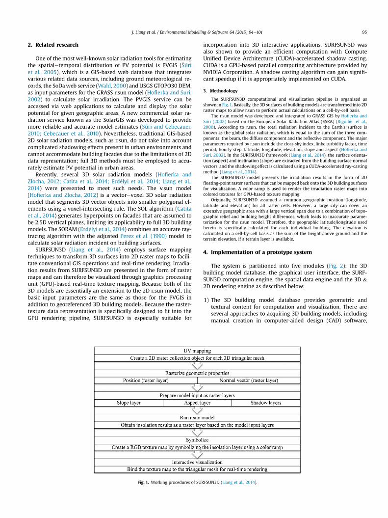
Fig. 1. Working procedures of SUR
incorporation into 3D interactive applications. SURFSUN3D wasalso shown to provide an efficient computation with ComputeUnified Device Architecture (CUDA)-accelerated shadow casting.CUDA is a GPU-based parallel computing architecture provided byNVIDIA Corporation. A shadow casting algorithm can gain signifi-cant speedup if it is appropriately implemented on CUDA.
3. Methodology
The SURFSUN3D computational and visualization pipeline is organized asshown in Fig. 1. Basically, the 3D surfaces of building models are transformed into 2Draster maps to allow r.sun to perform actual calculations on a cell-by-cell basis.
The r.sun model was developed and integrated to GRASS GIS by Hofierka andSuri (2002) based on the European Solar Radiation Atlas (ESRA) (Rigollier et al.,2000). According to r.sun, the total radiation incident to the Earth's surface isknown as the global solar radiation, which is equal to the sum of the three com-ponents: the beam, the diffuse component and the reflective component. The majorparameters required by r.sun include the clear-sky index, linke turbidity factor, timeperiod, hourly step, latitude, longitude, elevation, slope and aspect (Hofierka andSuri, 2002). In the SURFSUN3D framework (Liang et al., 2014), the surface orienta-tion (aspect) and inclination (slope) are extracted from the building surface normalvectors, and the shadowing effect is calculated using a CUDA-accelerated ray-castingmethod (Liang et al., 2014).
The SURFSUN3D model presents the irradiation results in the form of 2Dfloating-point raster surfaces that can bemapped back onto the 3D building surfacesfor visualization. A color ramp is used to render the irradiation raster maps intocolored textures for GPU-based texture mapping.
Originally, SURFSUN3D assumed a common geographic position (longitude,latitude and elevation) for all raster cells. However, a large city can cover anextensive geographic area with a large vertical span due to a combination of topo-graphic relief and building height differences, which leads to inaccurate parame-terization for the r.sun model. Therefore, the geographic latitude/longitude usedherein is specifically calculated for each individual building. The elevation iscalculated on a cell-by-cell basis as the sum of the height above ground and theterrain elevation, if a terrain layer is available.
4. Implementation of a prototype system
The system is partitioned into five modules (Fig. 2): the 3Dbuilding model database, the graphical user interface, the SURF-SUN3D computation engine, the spatial data engine and the 3D &2D rendering engine as described below:
1) The 3D building model database provides geometric andtextural content for computation and visualization. There areseveral approaches to acquiring 3D building models, includingmanual creation in computer-aided design (CAD) software,
FSUN3D (Liang et al., 2014).

Fig. 2. Workflow of the prototype system.
J. Liang et al. / Environmental Modelling & Software 64 (2015) 94e10196
building footprint-based extrusion, reconstruction from imag-ery or LiDAR point clouds. In the prototype system presentedhere, a building is simply split into two parts, namely a roof andfaçade, for potential retrieval by their spatial or semanticattributes.
2) Graphical user interface (Fig. 3). This module allows users toselect buildings or building components for calculation and tospecify the r.sun parameters, including the clear sky index, linketurbidity factor, time period and hourly step.
Fig. 3. Overview of the
3) SURFSUN3D computation engine. Amajority of the computationtime of SURFSUN3D is spent on shadowing calculations due tothe geometric complexity of 3D urban models. Therefore, aCUDA-accelerated high-performance ray-casting method hasbeen implemented (Liang et al., 2014). Currently, only triangularmeshes are considered in this shadowing algorithm, where treescan be modeled as triangulated objects to serve as shadow-casters. The SURFSUN3D model calculates solar irradiation fora 3D surface on a cell-by-cell basis using the r.sun model and
prototype system.
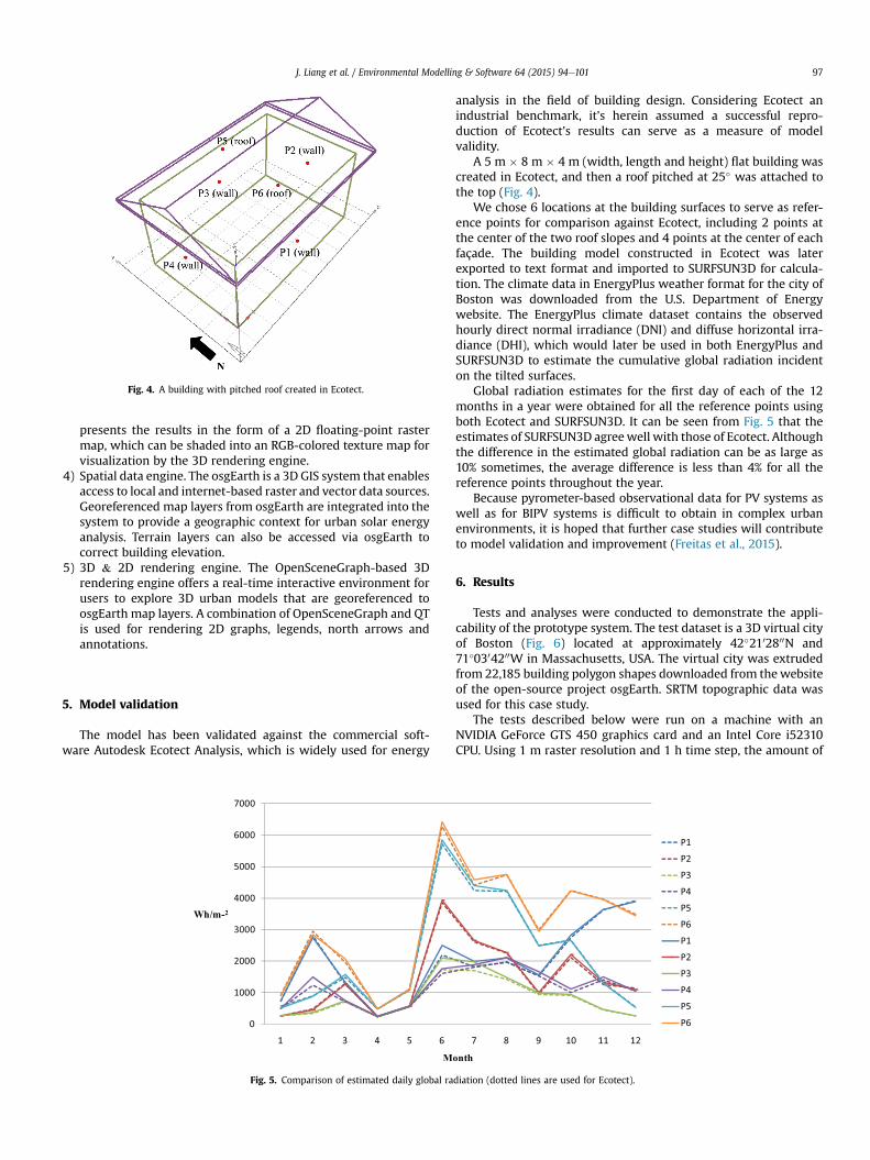
Fig. 4. A building with pitched roof created in Ecotect.
J. Liang et al. / Environmental Modelling & Software 64 (2015) 94e101 97
presents the results in the form of a 2D floating-point rastermap, which can be shaded into an RGB-colored texture map forvisualization by the 3D rendering engine.
4) Spatial data engine. The osgEarth is a 3D GIS system that enablesaccess to local and internet-based raster and vector data sources.Georeferenced map layers from osgEarth are integrated into thesystem to provide a geographic context for urban solar energyanalysis. Terrain layers can also be accessed via osgEarth tocorrect building elevation.
5) 3D & 2D rendering engine. The OpenSceneGraph-based 3Drendering engine offers a real-time interactive environment forusers to explore 3D urban models that are georeferenced toosgEarth map layers. A combination of OpenSceneGraph and QTis used for rendering 2D graphs, legends, north arrows andannotations.
5. Model validation
The model has been validated against the commercial soft-ware Autodesk Ecotect Analysis, which is widely used for energy
Fig. 5. Comparison of estimated daily global ra
analysis in the field of building design. Considering Ecotect anindustrial benchmark, it's herein assumed a successful repro-duction of Ecotect's results can serve as a measure of modelvalidity.
A 5 m � 8 m � 4 m (width, length and height) flat building wascreated in Ecotect, and then a roof pitched at 25� was attached tothe top (Fig. 4).
We chose 6 locations at the building surfaces to serve as refer-ence points for comparison against Ecotect, including 2 points atthe center of the two roof slopes and 4 points at the center of eachfaçade. The building model constructed in Ecotect was laterexported to text format and imported to SURFSUN3D for calcula-tion. The climate data in EnergyPlus weather format for the city ofBoston was downloaded from the U.S. Department of Energywebsite. The EnergyPlus climate dataset contains the observedhourly direct normal irradiance (DNI) and diffuse horizontal irra-diance (DHI), which would later be used in both EnergyPlus andSURFSUN3D to estimate the cumulative global radiation incidenton the tilted surfaces.
Global radiation estimates for the first day of each of the 12months in a year were obtained for all the reference points usingboth Ecotect and SURFSUN3D. It can be seen from Fig. 5 that theestimates of SURFSUN3D agreewell with those of Ecotect. Althoughthe difference in the estimated global radiation can be as large as10% sometimes, the average difference is less than 4% for all thereference points throughout the year.
Because pyrometer-based observational data for PV systems aswell as for BIPV systems is difficult to obtain in complex urbanenvironments, it is hoped that further case studies will contributeto model validation and improvement (Freitas et al., 2015).
6. Results
Tests and analyses were conducted to demonstrate the appli-cability of the prototype system. The test dataset is a 3D virtual cityof Boston (Fig. 6) located at approximately 42�2102800N and71�0304200W in Massachusetts, USA. The virtual city was extrudedfrom 22,185 building polygon shapes downloaded from thewebsiteof the open-source project osgEarth. SRTM topographic data wasused for this case study.
The tests described below were run on a machine with anNVIDIA GeForce GTS 450 graphics card and an Intel Core i52310CPU. Using 1 m raster resolution and 1 h time step, the amount of
diation (dotted lines are used for Ecotect).
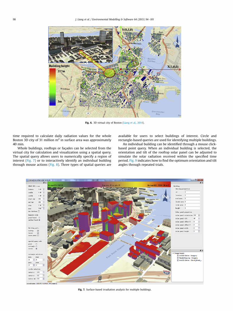
Fig. 6. 3D virtual city of Boston (Liang et al., 2014).
J. Liang et al. / Environmental Modelling & Software 64 (2015) 94e10198
time required to calculate daily radiation values for the wholeBoston 3D city of 31 million m2 in surface area was approximately40 min.
Whole buildings, rooftops or façades can be selected from thevirtual city for calculation and visualization using a spatial query.The spatial query allows users to numerically specify a region ofinterest (Fig. 7) or to interactively identify an individual buildingthrough mouse actions (Fig. 8). Three types of spatial queries are
Fig. 7. Surface-based irradiation a
available for users to select buildings of interest. Circle andrectangle-based queries are used for identifying multiple buildings.
An individual building can be identified through a mouse click-based point query. When an individual building is selected, theorientation and tilt of the rooftop solar panel can be adjusted tosimulate the solar radiation received within the specified timeperiod. Fig. 9 indicates how to find the optimum orientation and tiltangles through repeated trials.
nalysis for multiple buildings.

Fig. 8. Surface-based irradiation analysis for an individual building.
J. Liang et al. / Environmental Modelling & Software 64 (2015) 94e101 99
The user is required to interactively identify a position at abuilding, specify the r.sun parameters and specify the first andlast days to be included in calculation. The result is presentedin the form of a line graph that displays the irradiationagainst the number of days within the specified time period(Fig. 10).
Using the osgEarth spatial data engine, the buildings are accu-rately georeferenced and can be overlaid on various raster andvectormap layers provided by online or local data sources. In Fig.11,ArcGIS online satellite imagery and the street map provide anenriched geographic context for urban solar analysis.
7. Conclusions
To facilitate the assessment of photovoltaic potential in urbanenvironments, we have presented a computing framework that canbe used to develop 3D interactive applications with geospatial dataintegration capabilities. Compared to existing 3D solar radiationmodeling tools, the presented framework has the followingadvantages:
Fig. 9. Rooftop PV optimization
(1) The shadow casting algorithm can exploit GPU parallelism togain speedup.
(2) The surface mapping-based data representation is conve-nient for interactively visualizing the radiation attributes onbuilding surfaces.
(3) The integration with 3D GIS can facilitate the incorporationof multisource geospatial data in analysis and decision-making.
Because the application relies on real-time computations toproduce irradiation maps, the computational cost tends to increasewith the number of buildings intended for analysis. For instance,while calculation of daily radiation for a single building with 1 mraster resolution and 1 h time step may cost less than 1 s to a fewseconds, the whole Boston 3D city of 31 million m2 in surface arearequires half hour to several hours depending on computer per-formance using the same time step and raster resolution. At thecurrent stage, the program may be more suitable for early-stageassessment of photovoltaic potential since many practical factorsregarding PV installation and engineering have not been addressed,
for an individual building.

Fig. 10. Point-based irradiation analysis.
Fig. 11. Georeferencing to GIS data layers.
J. Liang et al. / Environmental Modelling & Software 64 (2015) 94e101100
for example, the electrical behavior of a shaded PV generator,angular and dust losses.
Acknowledgments
This research was supported and funded by the Key KnowledgeInnovative Project of the Chinese Academy of Sciences (KZCX2 EW318), the National Key Technology R&D Program of China(2014ZX10003002), and the National Natural Science Foundation ofChina (41371387), and Jiashan Science and technology Projects(2013B07, 2013A60).
References
Azadian, F., Radzi, M., 2003. A general approach toward building integratedphotovoltaic systems and its implementation barriers: a review. Renew. Sus-tain. Energy Rev. 22, 527e538.
Catita, C., et al., 2014. Extending solar potential analysis in buildings to verticalfacades. Comput. Geosci. 66, 1e12.
Cebecauer, T., et al., 2010. High Performance MSG Satellite Model for OperationalSolar Energy Applications. ASES National Solar Conference, Phoenix, USA.
Erd�elyi, R., Wang, Y., Guo, W., Hanna, E., Colantuono, G., 2014. Three-dimensionalSolar Radiation Model (SORAM) and its application to 3-D urban planning. Sol.Energy 101, 63e73.
Freitas, S., et al., 2015. Modelling solar potential in the urban environment: state-of-the-art review. Renew. Sustain. Energy Rev. 41, 915e931.

J. Liang et al. / Environmental Modelling & Software 64 (2015) 94e101 101
Hoffert, M., et al., 2002. Advanced technology paths to global climate stability:energy for a greenhouse planet. Science 298 (5595), 981e987.
Hofierka, J., Suri, M., 2002. The solar radiation model for open source GIS: imple-mentation and applications. In: Proceedings of the Open Source GISeGRASSUsers Conference 2002, Trento, Italy, 11e13, September 2002.
Hofierka, J., Zlocha, M., 2012. A new 3-D solar radiation model for 3-D city models.Trans. GIS 16 (5), 681e690.
James, T., et al., 2011. Building-integrated Photovoltaics (BIPV) in the ResidentialSector: an Analysis of Installed Rooftop System Prices. National renewable en-ergy laboratory. Technical Report NREL/TP-6A20e53103.
Kanters, J., Horvat, M., 2012. Solar energy as a design parameter in urban planning.Energy Procedia 30, 1143e1152.
Liang, J., et al., 2014. A visualization-oriented 3D method for efficient computationof urban solar radiation based on 3D-2D surface mapping. Int. J. Geogr. Inf. Sci.28 (4), 780e798.
Perez, R., et al., 1990. Modeling daylight availability and irradiance componentsfrom direct and global irradiance. Sol. Energy 44 (5), 271e289.
Rigollier, C., et al., 2000. On the clear sky model of the ESRA, European Solar Ra-diation Atlas, with respect to the Heliosat method. Sol. Energy 68, 33e48.
Schuetzeemail, T., 2013. Energies integration of photovoltaics in buildingsdsupportpolicies addressing technical and formal aspects. Energies 6 (6), 2982e3001.
�Súri, et al., 2005. PV-GIS: a web-based solar radiation database for the calculation ofPV potential in Europe. Int. J. Sustain. Energy 24 (2), 55e67.
�Súri, M., Cebecauer, T., 2010. SolarGIS: New Web-based Service Offering Solar Ra-diation Data and PV Simulation Tools for Europe, North Africa and Middle East.Conference EUROSUN 2010, October 2010, Graz, Austria.
Wald, L., 2000. SODA: a Project for the Integration and Exploitation of NetworkedSolar Radiation Databases. European Geophysical Society Meeting, XXV GeneralAssembly, Nice, France, 25e29 April 2000.