an iso 9001:2015 compliant company
TRANSCRIPT

AN ISO 9001:2015 COMPLIANT COMPANY
“We are a seamless extension of our clients’ organizations”
6700 Thompson Road, Suite 1
Syracuse, NY 13211
Tel: 315.695.7228
www.delta-eas.com
March 17, 2021 Mr. David J. Newman, Coastal Resources Specialist I Office of Planning, Development and Community Infrastructure Department of State One Commerce Plaza 99 Washington Avenue Albany, NY 12231-0001 RE: Joint Permit Application – D’Argenio/Caggiano, 24 & 28 Scharoun Drive, Pulaski, Oswego County, New York Delta Project No.: 2020.270.002 Dear Mr. Newman, Delta Engineers, Architects, Land Surveyors, & Landscape Architects, DPC (Delta) was contracted by Mr. Joseph Caggiano and Mr. Robert D’Argenio to prepare and submit a permit application to the US Army Corps of Engineers (Corps), NYS Department of Environmental Conservation (NYSDEC) NYS Office of General Services (NYSOGS), and NYS Department of State (NYSDOS) to protect the shoreline, repair earthen docks and dredge around the docks. The site is approximately 1.8 acres in size and is located at 24 & 28 Scharoun Drive and along the Salmon River in Pulaski, Oswego County, New York. A previous permit application package for this project was submitted in September 2019 (Department of State File No. F-2019-0972) and withdrawn on March 17, 2020 to prepare and provide additional information. The previously submitted application was assigned the following application numbers:
• Department of the Army Application No. 2019-01171, and • New York State Department of Environmental Conservation No. 7-3550-00353/00001.
Enclosed you will find the revised Joint Application for Permit Form and a supplemental report
containing a site overview, project details, a topographic figure of the site, the wetland delineation report, correspondence, design plans, and photographs.
If you have any questions or need additional information, please feel free to contact me
([email protected]) or Stephen L. Sheridan ([email protected]).
Respectfully, DELTA ENGINEERS, ARCHITECTS, LAND SURVEYORS, & LANDSCAPE ARCHITECTS, DPC
Shannon M. Booth Environmental Scientist

“We are a seamless extension of our clients’ organizations”
AN ISO 9001:2015 COMPLIANT COMPANY
Page 2 of 2
CC: Michael Uitvlugt, COE/Buffalo District Kevin Balduzzi, NYS DEC/Region 7 Emilio D’Argenio Enc.

JOINT APPLICATION FORM For Permits for activities activities affecting streams, waterways, waterbodies, wetlands, coastal areas, sources of water, and endangered and threatened species.
You must separately apply for and obtain Permits from each involved agency before starting work. Please read all instructions.
1. Applications To: >NYS Department of Environmental Conservation Check here to confirm you sent this form to NYSDEC.
Check all permits that apply: Dams and Impound- ment Structures
401 Water Quality Certification
Freshwater Wetlands
Tidal Wetlands
Wild, Scenic and Recreational Rivers
Coastal Erosion Management
Water Withdrawal
Long Island Well
Incidental Take of Endangered / Threatened Species
Stream Disturbance
Excavation and Fill in Navigable Waters
Docks, Moorings or Platforms
>US Army Corps of Engineers Check here to confirm you sent this form to USACE. Check all permits that apply: Section 404 Clean Water Act Section 10 Rivers and Harbors Act Is the project Federally funded? Yes No
If yes, name of Federal Agency: General Permit Type(s), if known: Preconstruction Notification: Yes No
>NYS Office of General Services Check here to confirm you sent this form to NYSOGS. Check all permits that apply:
State Owned Lands Under Water Utility Easement (pipelines, conduits, cables, etc.) Docks, Moorings or Platforms
>NYS Department of State Check here to confirm you sent this form to NYSDOS. Check if this applies: Coastal Consistency Concurrence
2. Name of Applicant Taxpayer ID (if applicant is NOT an individual)
Mailing Address Post Office / City State Zip
Telephone Email Applicant Must be (check all that apply): Owner Operator Lessee
3. Name of Property Owner (if different than Applicant)
Mailing Address Post Office / City State Zip
Telephone Email
For Agency Use Only Agency Application Number:
JOINT APPLICATION FORM 04/20 Page 1 of 4

JOINT APPLICATION FORM – Continued. Submit this completed page as part of your Application.
4. Name of Contact / Agent
Mailing Address Post Office / City State Zip
Telephone Email
5. Project / Facility Name Property Tax Map Section / Block / Lot Number:
Project Street Address, if applicable Post Office / City State Zip NY
Provide directions and distances to roads, intersections, bridges and bodies of water
Town Village City County Stream/Waterbody Name
Project Location Coordinates: Enter Latitude and Longitude in degrees, minutes, seconds: Latitude: ° ' " Longitude: ° ' "
6. Project Description: Provide the following information about your project. Continue each response and provideany additional information on other pages. Attach plans on separate pages.
a. Purpose of the proposed project:
b. Description of current site conditions:
c. Proposed site changes:
d. Type of structures and fill materials to be installed, and quantity of materials to be used (e.g., square feet ofcoverage, cubic yards of fill material, structures below ordinary/mean high water, etc.):
e. Area of excavation or dredging, volume of material to be removed, location of dredged material placement:
f. Is tree cutting or clearing proposed? Yes If Yes, explain below. No Timing of the proposed cutting or clearing (month/year):Number of trees to be cut: Acreage of trees to be cleared:
JOINT APPLICATION FORM 04/20 Page 2 of 4

JOINT APPLICATION FORM – Continued. Submit this completed page as part of your Application.
g. Work methods and type of equipment to be used:
h. Describe the planned sequence of activities:
i. Pollution control methods and other actions proposed to mitigate environmental impacts:
j. Erosion and silt control methods that will be used to prevent water quality impacts:
k. Alternatives considered to avoid regulated areas. If no feasible alternatives exist, explain how the project willminimize impacts:
l. Proposed use: Private Public Commercial
m. Proposed Start Date: Estimated Completion Date:
n. Has work begun on project? Yes If Yes, explain below. No
o. Will project occupy Federal, State, or Municipal Land? Yes If Yes, explain below. No
p. List any previous DEC, USACE, OGS or DOS Permit / Application numbers for activities at this location:
q. Will this project require additional Federal, State, or Local authorizations, including zoning changes?
Yes If Yes, list below. No
JOINT APPLICATION FORM 04/20 Page 3 of 4


AN ISO 9001:2015 COMPLIANT COMPANY
“We are a seamless extension of our clients’ organizations”
6700 Thompson Road, Suite 1
Syracuse, NY 13211
Tel: 315.695.7228
www.delta-eas.com
March 17, 2021
RE: Joint Permit Application – D’Argenio/Caggiano, 24 & 28 Scharoun Drive, Pulaski, Oswego County, New York Delta Project No.: 2020.270.002 Delta Engineers, Architects, Land Surveyors, & Landscape Architects, DPC (Delta) was contracted by Mr. Joseph Caggiano and Mr. Robert D’Argenio to prepare and submit a permit application to the US Army Corps of Engineers (Corps), NYS Department of Environmental Conservation (NYSDEC) NYS Office of General Services (NYSOGS), and NYS Department of State (NYSDOS) to protect the shoreline, repair earthen docks and dredge around the docks. The site is approximately 1.8 acres in size and is located at 24 & 28 Scharoun Drive and along the Salmon River in Pulaski, Oswego County, New York. Delta performed a wetland delineation on July 2, 2020 and found one wetland (Wetland A). Wetland A is assumed jurisdictional by the state (DEC) and federal (Corps). A previous permit application package for this project was submitted in September 2019 and withdrawn on March 17, 2020 to prepare and provide additional information.
This report contains an overview, history of the property and details of the proposed project. Following the text is a topographic figure illustrating the site location and boundary, as well as representative photographs of the site. “Appendix A – Wetland Delineation Report” includes Delta’s Wetland Delineation Report summarizing background information and data analyzed by Delta staff on the July 2, 2020 site visit. “Appendix B – Correspondence” includes (1) the Short Environmental Assessment Form (SEAF), (2) the Federal Consistency Assessment Form, (3) response letters to David Newman (NYSDOS) and Judy Robinson (Corps) (consecutively) containing additional requested information and plans, and (4) letters from NYSDOS and Corps regarding the original permit application. “Appendix C – Design Plans” includes revised plans for the proposed project which address NYSDOS and Corps requests/questions. “Appendix D – Photographs”. Overview
The properties at 24 and 28 Scharoun Drive are controlled by the Caggiano/D’Argenio family (Figure 1). The property at 28 Scharoun Drive was purchased in the early 1960’s by Joseph Caggiano. Prior to his purchase of the property, channels on both sides of the pier had been dredged and the pier constructed. The length of the pier was covered with 12” wide boards and was used for the owner’s boat dockage. Both Peninsulas had trees and they were mowed and maintained.
The property at 24 Scharoun Drive was purchased in 2013 by Robert D’Argenio. Mr. D’Argenio is a year-round resident.
Over the years the shorelines and pier have eroded, and silt has filled the boat docking area. The high water of 2017 accelerated the deterioration of the shoreline and pier. During this flood year, 10 feet of both peninsulas and a significant portion of the side of the peninsula number 2 were eroded by the high water (Photos 1-3 following the text). The small wetland next to peninsula number 2 ends up littered with debris each spring such as pieces of docks and litter that finds its way into the river during spring high flow events. The sediment deposited on top of both peninsulas due to the high water of 2017 made it impossible to mow and maintain them as in years past. The high water of the 2019 event has

“We are a seamless extension of our clients’ organizations”
AN ISO 9001:2015 COMPLIANT COMPANY
Page 2 of 7
compounded the problem. Peninsulas 1 and 2 and the pier (Peninsula 3) are labeled in Photo 1 in Appendix D.
The project involves the following:
1) Pier (Peninsula 3) To protect what remains of the pier and return it to serviceable condition, the property owners
are proposing to remove twenty (20) feet of the existing pier from the river end, install rip rap on that end and 20 feet down each side, and build a new pressure treated lumber retaining wall in front of the existing degraded wall. The pier will be stabilized. The rip rap at the end will protect the pier from the higher velocity flows in the river and the new retaining wall will prevent the loss of additional timbers of the old retaining wall. The old timbers have washed away in previous high flow events and become a threat to navigation.
2) Peninsulas
Peninsula 1 (western peninsula) The end of Peninsula 1, and 20 feet down the eastern side, will have appropriately sized rocks
(sized by an engineer) as protection from further erosion to the end of the peninsula. The area south of the placed rock on Peninsula 1 will be reinforced with a stabilizing material. A layer of rip rap, at roughly 1’ x 1’ or 1’ x 2’, will be placed at low water level at the base of the inside of the channel. Additional erosion control measures will be employed to prevent further erosion upslope of the rip rap. The slope in this area will be approximately 1:2 or 45 degrees. The corner at the base of this slope, and adjacent to the wetland, will be filled. A line of rip rap will be placed at low water level between Peninsula 1 and the adjacent wetland to prevent further erosion of the edges of the peninsula.
Dredge material from the bays will be dewatered on Peninsula 1 (water from this operation
will be routed back into the bay where the dredge was removed). Once the dredge material has dried it will be spread on the top of Peninsula 1. The height of the peninsulas will be raised approximately 1 to 1-1/2 feet. This will be roughly the same elevation as the pier. The length and width of the peninsulas will stay the same; only the elevation will increase. The back end (landwards end) of the bay will have a retaining wall installed to stabilize the bank. Pressure treated lumber will be installed at the water’s edge at the base of the hill where the ground meets the channel – a vertical rock wall with laid up stone currently exists at this location.
Peninsula 2 (eastern peninsula) The end of Peninsula 2, 20 feet down the western side and 30 feet down the eastern side, will
have appropriately sized rocks (sized by an engineer) as protection from further erosion to the end of the peninsula. The area south of the placed rock on the western side of Peninsula 2 will be reinforced with a stabilizing material. A layer of rip rap, at roughly 1’ x 1’ or 1’ x 2’, will be placed at low water level at the base of the inside of the channel. Additional erosion control measures will be employed to prevent further erosion upslope of the rip rap. The slope in this area will be approximately 1:2 or 45 degrees. The eastern corner of Peninsula 2 on the river side will be filled – this corner has been subject to significant erosion due to high water events and the normal annual spring water surge (Photos 26-28, Appendix D). A line of rip rap will be placed at low water level between Peninsula 2 and the adjacent wetland to prevent further erosion of the edges of the peninsula.

“We are a seamless extension of our clients’ organizations”
AN ISO 9001:2015 COMPLIANT COMPANY
Page 3 of 7
Dredge material from the bays will be dewatered on Peninsula 2 (water from this operation
will be routed back into the bay where the dredge was removed). Once the dredge material has dried it will be spread on the top of Peninsula 2. The height of the peninsulas will be raised approximately 1 to 1-1/2 feet. This will be roughly the same elevation as the pier. The length and width of the peninsulas will stay the same; only the elevation will increase. The bank located at the back end (landwards end) of the bay between Peninsula 2 and the pier will be stabilized and used as the boat launch (replacing the existing metal bridge material).
3) Dredging
In recent years, seasonal high water has risen to the height of the pier and has saturated and inundated the peninsulas (which are at a lower elevation than the pier), contributing to erosion and degradation (Photos 18-26, Appendix D). To prevent further degradation in coming years, the dredge from each channel will be used to raise the height of each peninsula to the same level as the top of the pier (approximately 1 to 1-1/2 feet). The hill in front of Peninsula 1 will be graded to have a more natural slope toward the wetland, Peninsula 1, and the channel.
Dredging will occur during seasonal low water. Additionally, floating silt screens (turbidity
curtains) will be run from the peninsulas to the pier. This will control turbidity in the work area during dredging. The dredge material is silty. The dredged area in the two bays will gently slope from the peninsulas down to 3 feet and maintain a constant 3-foot depth to the pier. 3 feet is the minimum amount of dredge spoils that need to be removed for the property owners. This will make the property useable for the owner’s boats in the months of August, September, and October.
4) Boat Ramp As discussed in the Peninsula 2 section above, the current boat launch made with metal bridge
material will be removed and will be replaced. The current metal ramp has a 20-foot width. The replacement ramp will be the same dimension.

Ü
Figure 1. NYS DOTTopographic Map
Site Location
Pulaski1993
Delta File: 2020.270.001-Fig1.mxd\7-7-2020
1 inch = 1,000 feet
0 1,000Feet
Prepared by Delta Engineers, Architects, and Land Surveyors
SITE LOCATION
Coordinates of Site
Latitude - 43.5661° NLongitude - -76.1906° WUTM 18T - E 403844m N 4824380m
ApproximateSite Location

Photo 1. Peninsula Number 1 in June 2019.

Photo 2. Peninsula Number 2 in June 2019.
Photo 3. Peninsula Number 3 in June 2019.

APPENDIX A – WETLAND DELINEATION REPORT

AN ISO 9001:2015 COMPLIANT COMPANY
“We are a seamless extension of our clients’ organizations”
6700 Thompson Road, Suite 1
Syracuse, NY 13211
Tel: 315.695.7228
www.delta-eas.com
October 26, 2020
Mr. Joseph Caggiano Mr. Robert D’Argerio C/O Kall & D’Argerio CPA’s, LLC 118 North Massey Street P.O. Box 720 Watertown, NY 13601 RE: Wetland Delineation 24 & 28 Scharoun Drive Parcels, Port Ontario, Town of Richland, Oswego County, New York Delta Project No.: 2020.270.001 Dear Mr. Caggiano and Mr. D’Argerio:
Delta Engineers, Architects, Land Surveyors, & Landscape Architects, DPC (Delta) conducted a wetland delineation at 24 and 28 Scharoun Drive in the Town of Richland, Oswego County, New York (Figure 1). The site is approximately 1.8 acres in size. Delta conducted this wetland delineation on July 2, 2020. The wetland delineation was conducted following the methods outlined in the U.S. Army Corps of Engineers (Corps) Manual (Environmental Laboratory 1987), the Corps Regional Supplement (2012) and the New York State Department of Environmental Conservation (NYSDEC) Manual (NYSDEC 1995).
This report includes a review of the background information, a methods section, results, which include site ecology and wetlands, and a summary of our findings.
Background Information
The New York State Department of Transportation (NYSDOT) topographic map (Figure 1) shows that the site is located on Scharoun Drive and is west of New York State Route 3 in Port Ontario, New York. The Salmon River borders the property on the north. The property is developed with several cottages and a boat dock. The property slopes to the northwest from approximately 280 feet above mean sea level (amsl) to approximately 240 feet amsl. The property consists of mowed lawn and emergent wetland.
The NYSDEC Freshwater Wetlands map (Figure 2) shows that freshwater wetland (PI-2), a class I wetland, is located on the northern portion of the site. The NYSDEC ranks freshwater wetlands with a class of I to IV, with I being the highest quality.
The National Wetlands Inventory (NWI) map (Figure 3) prepared by the United States Fish and Wildlife Service (USFWS) shows one NWI wetland in the northwestern portion of the site – PEM1F is a Palustrine Emergent, Persistent, Semipermanently Flooded wetland. The NWI map is intended as an advisory map and is not intended as a map of regulated wetlands.
The Soil Survey map (Figure 4) obtained from the Oswego County Soil Survey shows that the site contains three (3) mapped soil series: Humaquepts and Fibrists, ponded (Hw); Ira gravelly fine sandy loam, 3 to 8 percent slopes (IrB); and Water (W). The soils types, drainage class, and hydric rating are shown in Table 1 below.

“We are a seamless extension of our clients’ organizations”
AN ISO 9001:2015 COMPLIANT COMPANY
Page 2 of 9
Table 1. Soil Type with Drainage Class and Hydric Rating
Soil Type Drainage Class Hydric Rating (%) Hw – Humaquepts and Fibrists, Ponded Very Poorly drained 25 IrB – Ira gravelly fine sandy loam, 3 to 8
percent slopes Moderately Well Drained 0
W – Water N/A N/A
Humaquepts and Fibrists, ponded (Hw) is a very poorly drained, hydric (wetland) soil that is shown on the western portion of the site. Ira gravelly fine sandy loam, 3 to 8 percent slopes (IrB) is moderately drained and is found in the eastern portion of the site. Water (W) is found in the northern portion of the site in connection with the Salmon River. The Oswego County Hydric Soils list identifies Hw as a hydric soil.
The Surface Water Classification map (Figure 5) prepared by the NYSDEC shows that the Salmon River is a Class C water with Class C standards. Salmon River runs within the northern boundary of the site.
The Flood Insurance Rate Map (Figure 6) shows that the northeastern portion of the site is located in Floodway Areas of Zone AE. Zone AE is subject to inundation by 1% annual chance flood, frequently called the 100-year floodplain. Floodway Areas of Zone AE must be kept free of encroachment so that the 1% annual chance flood can be carried without substantial increases in flood heights.
The aerial photograph of the project site (Figure 7) shows that the site is developed with several cottages, mowed lawn, open field areas, and a boat dock area bordered by emergent vegetation associated with the Salmon River. It should be noted the boat dock has been in place on this site since approximately 1975 when an aerial photograph was used as the base map for the soil survey. The area next to the Salmon River had been excavated and dredged to support a boat dock over 45 years ago.
Methods
Flagging of the wetlands on the site and the data collection at the boundaries were conducted by Delta on July 2, 2020. The boundaries were delineated using the federal criteria for vegetation, soils, and hydrology (Environmental Laboratory 1987, Lichvar et al. 2016, USDA NRCS 2016, U.S. Army Corps of Engineers (Corps) 2012), and the NYSDEC Freshwater Wetlands Manual (NYSDEC 1995).
Surveyor’s ribbon was placed along the wetland boundaries based on observations of vegetation, soils, and hydrology conditions. Patsy A. Storino, P.L.S. surveyed the locations of the wetlands delineated on the site. Delta calculated the approximate area of wetlands within the site.
To further support the wetland boundaries, data on the vegetation, soils, and hydrology were obtained from sample plots located within the wetland boundaries. Delta sampled two plots in and around the wetland and upland sides of the flagged wetland boundaries. The plot data were recorded on data sheets that comply with those used in the regional supplement (Corps 2012).
Vegetation data were collected in all sample plots. Ocular estimates of the percent areal cover by plant species for each vegetation layer (tree, shrub, and herbaceous) were recorded. The sample plots varied in size according to the vegetation layer being sampled. The sizes were: 30-foot radius for the tree layer, 15-foot radius for the shrub layer, and 5-foot radius for the herbaceous layer.
The presence of wetland vegetation was determined when more than 50 percent of the dominant species in a sample plot had an indicator status of obligate (OBL), facultative-wet (FACW), or facultative (FAC).

“We are a seamless extension of our clients’ organizations”
AN ISO 9001:2015 COMPLIANT COMPANY
Page 3 of 9
The dominant species for each layer in a plot were determined by ranking the species in decreasing order of percent cover and recording those species which, when cumulatively totaled, immediately exceeded 50 percent of the total cover of that layer. Additionally, any plant species that comprised 20 percent or more of the total cover for each layer was considered to be a dominant species.
Plant species were identified primarily using the Manual of Vascular Plants of Northeastern United States and Adjacent Canada (Gleason and Cronquist 1991), New Britton and Brown Illustrated Flora (Gleason 1952), Gray’s Manual of Botany (Fernald 1950). Scientific nomenclature follows the Regional Wetland Plant List (Lichvar et al. 2016), A Checklist of New York State Plants (Mitchell and Tucker 1997), and Catalogue of the Vascular Plants of New York State (Werier 2017). The indicator status for each plant species was determined using the Regional Wetland Plant List (Lichvar et al. 2016).
Soil and hydrology data were collected in soil pits or soil borer holes to a minimum depth of 18 inches within each sample plot. Soil characteristics were noted along the soil profile at the depth specified by the Corps criteria (Lichvar et al. 2016). Procedures for identifying hydric soils as outlined in the Field Indicators of Hydric Soils in the United States (USDA NRCS 2016) were also followed. Soil colors were determined by using the Munsell color chart. Primary and secondary indicators of hydrology were also noted at each sample plot. The wetland boundaries were refined on the basis of intermediate soil borer holes along each transect.
Results
Wetland areas are described in the wetland section. Data sheets for wetlands on the site are included in Appendix A. Photographs of the wetlands on the site are included in Appendix B.
Site Ecology
The upland portion of the site consists of open field and mowed lawn. The open field area is dominated by woodland bluegrass (Poa sylvestris) and narrow-leaved plantain (Plantago lanceolata). Historic aerial photographs indicate that the eastern portion of the site next to the boat dock had contained deciduous forest.
Wetlands and Waters
Delta located one wetland area when conducting the wetland delineation (Figure 8). Delta identified this as Wetland A. Wetland determination data sheets are found in Appendix A and photographs are shown in Appendix B. Wetland locations are shown on Figure 8. Wetland plot and photograph locations are shown on Figure 9.
Table 2. Wetland Summary
Wetland(a) Primary Cover Types (s)(b) Jurisdiction(c) A Palustrine Emergent Marsh (PEM) State (DEC) and Federal (Corps)
(a) Wetlands delineated by Delta Engineers, Architects, Land Surveyors, & Landscape Architects, DPC (Delta) on July 2, 2020. The wetland boundaries were surveyed by Patsy A. Storino, P.L.S.
(b) Wetland cover types observed by Delta on July 2, 2020. (c) Assumed jurisdiction based on map resource information and the field review by Delta.

“We are a seamless extension of our clients’ organizations”
AN ISO 9001:2015 COMPLIANT COMPANY
Page 4 of 9
Wetland A Wetland A is located in the northern portion of the site (Figure 8), and is located in part of NYSDEC
Freshwater Wetland, PI-2 (Figure 2), and NWI mapped wetland, PEM1F (Figure 3). Wetland A is approximately 0.59 acre within the site.
Wetland A is dominated by narrowleaf cattail (Typha angustifolia) and moneywort (Lysimachia nummularia) in the herbaceous layer.
Soils present in Wetland A were mapped as Humaquepts and Fibrists, ponded (Figure 4). Soil samples displayed the Depleted Below Dark Surface (A11) and Depleted Matrix (F3) Hydric Soil Indicators.
Wetland hydrology was indicated by 6-inches of Surface Water (A1), High Water Table (A2), Saturation (A3), Water Marks (B1), and FAC-Neutral Test (D5) as Wetland Hydrology Indicators.
Permitting
Direct impacts to wetlands on the site will require permits from the U.S. Army Corps of Engineers and the NYSDEC. The property is also within the coastal zone limit and is subject to the Coastal Zone Consistency Regulations. The NYSDEC will also require an Article 24 Freshwater Wetlands Permit for impacts to the state-regulated wetland and its 100-foot upland adjacent area to Wetland A (Figure 8).
Summary
Delta Engineers, Architects, Land Surveyors, & Landscape Architects, DPC was contracted to delineate wetlands on the proposed project site. The approximately 1.8-acre site is located on 24-28 Scharoun Drive in Port Ontario (Town Richland), Oswego County, New York. Delta conducted this wetland delineation on July 2, 2020.
Delta reviewed available background information maps prior to the field review. The site slopes to the northwest, down from the cottage area to the boat dock and adjoining wetlands. The NYSDEC freshwater wetlands map shows freshwater wetland PI-2, a class I wetland, on the site. The NWI map shows one mapped wetland on site – PEM1F is a Palustrine Emergent, Persistent, Semipermanently Flooded wetland. The site contains three (3) mapped soil series: Humaquepts and Fibrists, ponded (Hw); Ira gravelly fine sandy loam, 3 to 8 percent slopes (IrB); and Water (W). Salmon River borders the site to the north. The northern portion of the site is located in the Floodway Areas of Zone AE, which includes areas subject to inundation by the 1% annual chance flood.
Delta located one wetland on the site. Wetland A is a palustrine emergent marsh connected to the Salmon River. This wetland is assumed jurisdictional by the Corps, the NYSDEC, and the Department of State. The NYSDEC also regulates a 100-foot upland adjacent area from the edge of the wetland.
Permits will be required from the USACOE for work within the wetland. The NYSDEC will need to provide permits for work in the wetland or the NYSDEC regulated 100-foot adjacent area. The property is also within the coastal zone limit and is subject to the Coastal Zone Consistency Regulations.

“We are a seamless extension of our clients’ organizations”
AN ISO 9001:2015 COMPLIANT COMPANY
Page 5 of 9
I trust this letter report is sufficient for your needs. If you have any questions or need additional information, please contact me.
Respectfully, DELTA ENGINEERS, ARCHITECTS, LAND SURVEYORS, & LANDSCAPE ARCHITECTS, DPC
Stephen L. Sheridan Senior Environmental Scientist Enc.

“We are a seamless extension of our clients’ organizations”
AN ISO 9001:2015 COMPLIANT COMPANY
Page 6 of 9
REFERENCES Environmental Laboratory. 1987. Corps of Engineers Wetlands Delineation Manual. Technical Report
Y-87-1, U.S. Army Engineer Waterways Experiment Station, Vicksburg, MS.
Fernald, M. L. 1950. Gray's Manual of Botany, 8th Edition. American Book Company, New York, NY.
Gleason, H. A. 1952. The New Britton and Brown Illustrated Flora of the United States and Adjacent Canada. Hafner Press, New York, NY (3 vols).
Gleason, H. A. and A. Cronquist. 1991. Manual of Vascular Plants of Northeastern United States and Adjacent Canada. The New York Botanical Garden, Bronx NY.
Lichvar, Robert W., D. L. Banks, W. N., G. Kirchner, and N.C. Melvin. 2016. Northcentral and Northeast 2016 Regional Wetland Plant List. The National Wetland Plant List: 2016 Wetland Ratings. Phytoneuron 2016 30: 1-17 published 28 April 2016.
Mitchell, R. S. and G. C. Tucker. 1997. A Revised Checklist of New York State Plants. The State Education Department, NYS Museum Bulletin No. 490, Albany, NY.
NYSDEC. 1995. Freshwater Wetlands Delineation Manual. New York State Department of Environmental Conservation Division of Fish and Wildlife, Albany, NY.
United States Army Corps of Engineers. 2012. Regional Supplement to the Corps of Engineers Wetland Delineation Manual: Northcentral and Northeast Region (Version 2.0), ed. J. S. Wakeley, R. W. Lichvar, C. V. Noble, and J. F. Berkowitz. ERDC/EL TR-12-1. Vicksburg, MS: U.S. Army Engineer Research and Development Center.
United States Department of Agriculture Natural Resource Conservation Service. 2016. Field Indicators of Hydric Soils in the United States, Version 8.0. L.M. Vasilas, G.W. Hurt, and J.F. Berkowitz (eds.). USDA, NRCS, in cooperation with the National Technical Committee for Hydric Soils.
Werier, D. 2017. Catalogue of the Vascular Plants of New York State. Memoirs of the Torrey Botanical Society: Volume 27. The Torrey Botanical Society. Bronx, New York.

FIGURES

Ü
Figure 1. NYS DOTTopographic Map
Site Location
Pulaski1993
Delta File: 2020.270.001-Fig1.mxd\7-7-2020
1 inch = 1,000 feet
0 1,000Feet
Prepared by Delta Engineers, Architects, and Land Surveyors
SITE LOCATION
Coordinates of Site
Latitude - 43.5661° NLongitude - -76.1906° WUTM 18T - E 403844m N 4824380m
ApproximateSite Location

PI-2
PI-2
PI-1
PI-2
PI-2
PI-2
PI-2
PI-1
PI-2
PI-2PI-2
PI-2
Ü1 inch = 1,000 feet
0 1,000Feet
Prepared by Delta Engineers, Architects, and Land Surveyors
SITE LOCATION
ApproximateSite Location
Figure 2. NYS FreshwaterWetlands Map
NYS Department ofEnvironmental Conservation
cugir.mannlib.cornell.edu
Delta File: 2020.270.001-Fig2.mxd\7-7-2020
Oswego1998

R2UBH
PFO1E
PEM1F
PSS1E
PEM1F
PEM1F
PEM1E
PEM1F
PEM1F
PFO1E
PEM1F
PEM1F
L1UBH
PEM1F
R3UBH
PFO1/SS1E
PSS1/FO1E
PFO1E
PEM1F
PEM1E
PSS1E
L1UBH
PFO1/SS1E
PEM1F
PUBH
PEM1F
L2USJ
PSS1E
PEM1A
PSS1E
PEM1F PSS1E
PEM1F
PEM1F
PEM1A
PEM1F
PUBHx
PFO1APUBH
PEM1F
PEM1A
PSS1E
PUBH
PSS1E
PEM1F
PEM1F
PUBHx
PEM1A
PEM1E
PUBH
PUBHx
PEM1F
PEM1F
PUBHx
PUBH
PEM1FPSS1E
PUBHx
PUBHx
PUBHx
PUBF
PEM1FPEM1F
PUBHx
L2USJ
PUBHx
Ü1 inch = 1,000 feet
0 1,000Feet
Prepared by Delta Engineers, Architects, and Land Surveyors
SITE LOCATION
ApproximateSite Location
Figure 3. National WetlandsInventory Map
U.S. Fish & Wildlife Servicewww.fws.gov/nwi
Delta File: 2020.270.001-Fig3.mxd\7-7-2020
Pulaski2018

W
IrB
IrB
HW
ScB
W
HW
OaB
HW
ScB
HW
RaBAvB
AAC
DeB
HW
HW
HW
RaB
SHF
Lf
GP
HW
HW
ScB
WlB
HW
HW
AgB
AgB
HW
FA
AyD3
Fr
FA
Ü1 inch = 500 feet
0 500Feet
Prepared by Delta Engineers, Architects, and Land Surveyors
SITE LOCATION
ApproximateSite Location
Figure 4. Soil Survey Map
Natural Resources Conservation ServiceSoil Survey Geographic Database
(NRCS SSURGO)
Delta File: 2020.270.001-Fig4.mxd\7-7-2020
Oswego County Soil Survey2013
Hw -IrB -W -
Humaquepts and Fibrists, ponded.Ira gravelly fine sandy loam, 3 to 8 percent slopes.Water.
Soil Legend
- Hydric Soil

Ü1 inch = 1,000 feet
0 1,000Feet
ApproximateSite Location
Figure 5. Surface WaterClassification Map
NYS DEC
Delta File: 2020.270.001-Fig5.mxd\7-7-2020
Pulaski Quadrangle
Prepared by Delta Engineers, Architects, and Land Surveyors
Title 6 NYCRR, Chapter XArticle 9, Part 847.5 (2020)
Map F-15sw
Salmon River

NORTH
0' 500'250'
SCALE 1" = 500'
Figure 6. Flood Insurance Rate Map
AgencyFederal Emergency Management
Town of Richland, NY
Prepared by Delta Engineers, Architects, Surveyors, & Landscape Architects.
Panel Numbers:
36075C01546(Effective Date 6/18/2013)
Delta File: 2020.270.001-Fig6.cdr\7-7-2020
ApproximateSite Location
LEGEND
Floodway Areas of Zone AE -
Must be kept free of encroachment so that the 1% annual chanceflood can be carried without substantial increases in flood heights.
Ü1 inch = 50 feet
0 50
Feet
Aerial Photograph Obtained from NYS GIS Clearinghouse
2015
Figure Prepared byDelta Engineers, Architects,
and Land Surveyors
Figure 7.
Aerial Photographof Site
Delta File: 2020.270.001-Aerial.mxd\7-7-2020
Approximate Site Location
(Approx. 1.8 acres)
Scha
roun
Driv
e

Figure 8.
Wetland SurveyMap
Base Map Provided byPatsy A. Storino, P.L.S.
Figure Prepared byDelta Engineers, Architects,
Land Surveyors, & LandscapeArchitects, DPC
0' 50' 25'
NORTH
APPROXIMATE SCALE IN FEET
Delta File: 2020.270.001\2020.270.001-Fig8.cdr\10-22-2020
A-1
Wetland A Location
Flag Number
LEGEND
ApproximateSite Location
Wetland AOn-Site Area (Acres)
0.59
Wetland A
Wetland A
Wetland A
Wetland A
A-1
A-6
A-11
A-14
A-26
A-19
A-28
NYS DEC Regulated100’ Adjacent Area(Approx. Location)
NYS DEC Regulated100’ Adjacent Area(Approx. Location)
NYSDEC Regulated100’ Adjacent Area(Approx. Location)

Figure 9.
Wetland Boundaries withSample Plot and
Photograph Locations
Base Map Provided byPatsy A. Storino, P.L.S.
Figure Prepared byDelta Engineers, Architects,
Land Surveyors, & LandscapeArchitects, DPC
0' 50' 25'
NORTH
APPROXIMATE SCALE IN FEET
Delta File: 2020.270.001\2020.270.001-Fig9.cdr\10-22-2020
A-1W Sample Plot Location
Photo Location andDirection
LEGEND
ApproximateSite Location
Wetland A
A-1W
Wetland A
14
9
8
6
5
1
A-1U
1513
12
1110
7
43
2
1
Wetland A
A-1
A-6
A-11
A-14
A-26
A-19
A-28

APPENDIX A – FIELD DATA SHEETS

Project/Site:
Applicant/Owner: State:
Investigator(s):
Lat:
Soil Map Unit Name: NWI classification:
X
Are Vegetation , Soil , or Hydrology Yes X
Are Vegetation , Soil , or Hydrology
SUMMARY OF FINDINGS – Attach site map showing sampling point locations, transects, important features, etc.
No XNo X XNo X
XXX Yes X
WETLAND DETERMINATION DATA FORM – Northcentral and Northeast Region
2020.270.001 City/County: Port Ontario/Oswego Sampling Date: 7/2/2020
Landform (hillside, terrace, etc.): hill slope Local relief (concave, convex, none): Slope %: 3
Caggiano NY Sampling Point: A-1U
BC Section, Township, Range:
NAD83
IrB - Ira gravelly fine sandy loam, 3 to 8 percent slopes N/A
Are climatic / hydrologic conditions on the site typical for this time of year? Yes No (If no, explain in Remarks.)
Subregion (LRR or MLRA): LRR L, MLRA 101 43.566611 Long: -76.190515 Datum:
significantly disturbed? Are “Normal Circumstances” present? No
naturally problematic? (If needed, explain any answers in Remarks.)
Hydrophytic Vegetation Present? Yes
Wetland Hydrology Present? Yes If yes, optional Wetland Site ID:
Is the Sampled AreaHydric Soil Present? Yes within a Wetland? Yes No
Remarks: (Explain alternative procedures here or in a separate report.)
HYDROLOGYWetland Hydrology Indicators: Secondary Indicators (minimum of two required)Primary Indicators (minimum of one is required; check all that apply) Surface Soil Cracks (B6)
Surface Water (A1)
Water Marks (B1) Hydrogen Sulfide Odor (C1) Crayfish Burrows (C8)Sediment Deposits (B2) Oxidized Rhizospheres on Living Roots (C3) Saturation Visible on Aerial Imagery (C9)
Water-Stained Leaves (B9) Drainage Patterns (B10)High Water Table (A2) Aquatic Fauna (B13) Moss Trim Lines (B16)Saturation (A3) Marl Deposits (B15) Dry-Season Water Table (C2)
Iron Deposits (B5) Thin Muck Surface (C7) Shallow Aquitard (D3)Inundation Visible on Aerial Imagery (B7) Other (Explain in Remarks) Microtopographic Relief (D4)
Drift Deposits (B3) Presence of Reduced Iron (C4) Stunted or Stressed Plants (D1)Algal Mat or Crust (B4) Recent Iron Reduction in Tilled Soils (C6) Geomorphic Position (D2)
Water Table Present? Yes No Depth (inches):
Sparsely Vegetated Concave Surface (B8) FAC-Neutral Test (D5)
Field Observations:Surface Water Present? Yes No Depth (inches):
Remarks:
No(includes capillary fringe)Describe Recorded Data (stream gauge, monitoring well, aerial photos, previous inspections), if available:
Saturation Present? Yes No Depth (inches): Wetland Hydrology Present?
US Army Corps of Engineers Northcentral and Northeast Region – Version 2.0

Sampling Point:
(Plot size:
1.
2.
3.
4.
5.
6. (A/B)
7.
Sapling/Shrub Stratum (Plot size: x 1 =
1. x 2 =
2. x 3 =
3. x 4 =
4. x 5 =
5. Column Totals: (B)
6.
7.
Herb Stratum (Plot size:
1.
2. 4 - Morphological Adaptations1 (Provide supporting
3.
4.
5.
6.
7.
8.
9.
10.
11.
12.
(Plot size:
1.
2.
3.
4. X
VEGETATION – Use scientific names of plants. A-1U
Tree Stratum 30 )Absolute % Cover
Dominant Species?
Indicator Status Dominance Test worksheet:
Number of Dominant Species That Are OBL, FACW, or FAC: 1 (A)
Total Number of Dominant Species Across All Strata: 2 (B)
Percent of Dominant Species That Are OBL, FACW, or FAC: 50.0%
Prevalence Index worksheet:
FAC species 40 120
0 0
Total % Cover of:
10
UPL species 0 0
FACU species 70
=Total Cover
410
Prevalence Index = B/A = 3.57
115 (A)
15 ) OBL species
Multiply by:
FACW species 5
280
=Total Cover 1 - Rapid Test for Hydrophytic Vegetation
5 ) 2 - Dominance Test is >50%
Hydrophytic Vegetation Indicators:
Plantago lanceolata 30 Yes FACU 3 - Prevalence Index is ≤3.01
Phleum pratense 20 No FACU
Problematic Hydrophytic Vegetation1 (Explain)
Trifolium hybridum 20 No FACU 1Indicators of hydric soil and wetland hydrology must be present, unless disturbed or problematic.
Lysimachia nummularia 5 No FACW data in Remarks or on a separate sheet)
Poa sylvestris 40 Yes FAC
Sapling/shrub – Woody plants less than 3 in. DBH and greater than or equal to 3.28 ft (1 m) tall.
Definitions of Vegetation Strata:
Tree – Woody plants 3 in. (7.6 cm) or more in diameter at breast height (DBH), regardless of height.
Woody Vine Stratum 30 ) Woody vines – All woody vines greater than 3.28 ft in height.
Herb – All herbaceous (non-woody) plants, regardless of size, and woody plants less than 3.28 ft tall.115 =Total Cover
Hydrophytic Vegetation Present? Yes No
Remarks: (Include photo numbers here or on a separate sheet.)
=Total Cover
US Army Corps of Engineers Northcentral and Northeast Region – Version 2.0

Sampling Point:
X
SOIL A-1U
Profile Description: (Describe to the depth needed to document the indicator or confirm the absence of indicators.)Depth Matrix Redox Features(inches) Color (moist) % Color (moist) % Type1
4-16 10YR 4/4
Loamy/Clayey
Loc2 Texture Remarks
Loamy/Clayey
Loamy/Clayey16-18 10YR 3/2 95 10YR 4/6 5
Hydric Soil Indicators: Indicators for Problematic Hydric Soils3:Histosol (A1) Polyvalue Below Surface (S8) (LRR R, 2 cm Muck (A10) (LRR K, L, MLRA 149B)Histic Epipedon (A2) MLRA 149B) Coast Prairie Redox (A16) (LRR K, L, R)Black Histic (A3) Thin Dark Surface (S9) (LRR R, MLRA 149B) 5 cm Mucky Peat or Peat (S3) (LRR K, L, R)Hydrogen Sulfide (A4) High Chroma Sands (S11) (LRR K, L) Polyvalue Below Surface (S8) (LRR K, L)
1Type: C=Concentration, D=Depletion, RM=Reduced Matrix, MS=Masked Sand Grains. 2Location: PL=Pore Lining, M=Matrix.
Thick Dark Surface (A12) Depleted Matrix (F3) Piedmont Floodplain Soils (F19) (MLRA 149B)Sandy Mucky Mineral (S1) Redox Dark Surface (F6) Mesic Spodic (TA6) (MLRA 144A, 145, 149B)
Stratified Layers (A5) Loamy Mucky Mineral (F1) (LRR K, L) Thin Dark Surface (S9) (LRR K, L)Depleted Below Dark Surface (A11) Loamy Gleyed Matrix (F2) Iron-Manganese Masses (F12) (LRR K, L, R)
0-4 10YR 4/2
Stripped Matrix (S6) Marl (F10) (LRR K, L) Other (Explain in Remarks)Dark Surface (S7)
3Indicators of hydrophytic vegetation and wetland hydrology must be present, unless disturbed or problematic.
Sandy Gleyed Matrix (S4) Depleted Dark Surface (F7) Red Parent Material (F21)Sandy Redox (S5) Redox Depressions (F8) Very Shallow Dark Surface (F22)
Yes No
Remarks:This data form is revised from Northcentral and Northeast Regional Supplement Version 2.0 to include the NRCS Field Indicators of Hydric Soils, Version 7.0, 2015 Errata. (http://www.nrcs.usda.gov/Internet/FSE_DOCUMENTS/nrcs142p2_051293.docx)
Restrictive Layer (if observed):Type:
Depth (inches): Hydric Soil Present?
US Army Corps of Engineers Northcentral and Northeast Region – Version 2.0
Project/Site:
Applicant/Owner: State:
Investigator(s):
Lat:
Soil Map Unit Name: NWI classification:
X
Are Vegetation , Soil , or Hydrology Yes X
Are Vegetation , Soil , or Hydrology
SUMMARY OF FINDINGS – Attach site map showing sampling point locations, transects, important features, etc.
X NoX No XX No
XXXX
X
XXX Yes X
WETLAND DETERMINATION DATA FORM – Northcentral and Northeast Region
2020.270.001 City/County: Port Ontario/ Oswego Sampling Date: 7/2/2020
Landform (hillside, terrace, etc.): Toe of slope Local relief (concave, convex, none): concave Slope %:
Caggiano NY Sampling Point: A-1W
BC Section, Township, Range:
NAD83
Hw - Humaquepts and Fibrists, ponded PEM1F
Are climatic / hydrologic conditions on the site typical for this time of year? Yes No (If no, explain in Remarks.)
Subregion (LRR or MLRA): LRR L, MLRA 101 43.566550 Long: -76.190800 Datum:
significantly disturbed? Are “Normal Circumstances” present? No
naturally problematic? (If needed, explain any answers in Remarks.)
Hydrophytic Vegetation Present? Yes
Wetland Hydrology Present? Yes If yes, optional Wetland Site ID:
Is the Sampled AreaHydric Soil Present? Yes within a Wetland? Yes No
Remarks: (Explain alternative procedures here or in a separate report.)
HYDROLOGYWetland Hydrology Indicators: Secondary Indicators (minimum of two required)Primary Indicators (minimum of one is required; check all that apply) Surface Soil Cracks (B6)
Surface Water (A1)
Water Marks (B1) Hydrogen Sulfide Odor (C1) Crayfish Burrows (C8)Sediment Deposits (B2) Oxidized Rhizospheres on Living Roots (C3) Saturation Visible on Aerial Imagery (C9)
Water-Stained Leaves (B9) Drainage Patterns (B10)High Water Table (A2) Aquatic Fauna (B13) Moss Trim Lines (B16)Saturation (A3) Marl Deposits (B15) Dry-Season Water Table (C2)
Iron Deposits (B5) Thin Muck Surface (C7) Shallow Aquitard (D3)Inundation Visible on Aerial Imagery (B7) Other (Explain in Remarks) Microtopographic Relief (D4)
Drift Deposits (B3) Presence of Reduced Iron (C4) Stunted or Stressed Plants (D1)Algal Mat or Crust (B4) Recent Iron Reduction in Tilled Soils (C6) Geomorphic Position (D2)
6Water Table Present? Yes No Depth (inches):
Sparsely Vegetated Concave Surface (B8) FAC-Neutral Test (D5)
Field Observations:Surface Water Present? Yes No Depth (inches):
Remarks: Wetland starts at toe of slopes.
No(includes capillary fringe)Describe Recorded Data (stream gauge, monitoring well, aerial photos, previous inspections), if available:
Saturation Present? Yes No Depth (inches): Wetland Hydrology Present?
US Army Corps of Engineers Northcentral and Northeast Region – Version 2.0

Sampling Point:
(Plot size:
1.
2.
3.
4.
5.
6. (A/B)
7.
Sapling/Shrub Stratum (Plot size: x 1 =
1. x 2 =
2. x 3 =
3. x 4 =
4. x 5 =
5. Column Totals: (B)
6.
7.
Herb Stratum (Plot size: X
1. X
2. 4 - Morphological Adaptations1 (Provide supporting
3.
4.
5.
6.
7.
8.
9.
10.
11.
12.
(Plot size:
1.
2.
3.
4. X
VEGETATION – Use scientific names of plants. A-1W
Tree Stratum 30 )Absolute % Cover
Dominant Species?
Indicator Status Dominance Test worksheet:
Number of Dominant Species That Are OBL, FACW, or FAC: 2 (A)
Total Number of Dominant Species Across All Strata: 2 (B)
Percent of Dominant Species That Are OBL, FACW, or FAC: 100.0%
Prevalence Index worksheet:
FAC species 0 0
80 80
Total % Cover of:
66
UPL species 0 0
FACU species 0
=Total Cover
146
Prevalence Index = B/A = 1.29
113 (A)
15 ) OBL species
Multiply by:
FACW species 33
0
=Total Cover 1 - Rapid Test for Hydrophytic Vegetation
5 ) 2 - Dominance Test is >50%
Hydrophytic Vegetation Indicators:
Typha angustifolia 55 Yes OBL 3 - Prevalence Index is ≤3.01
Lysimachia nummularia 30 Yes FACW
Problematic Hydrophytic Vegetation1 (Explain)
Brasenia schreberi 20 No OBL 1Indicators of hydric soil and wetland hydrology must be present, unless disturbed or problematic.
Peltandra virginica 5 No OBL data in Remarks or on a separate sheet)
Cornus sericea 3 No FACW
Sapling/shrub – Woody plants less than 3 in. DBH and greater than or equal to 3.28 ft (1 m) tall.
Definitions of Vegetation Strata:
Tree – Woody plants 3 in. (7.6 cm) or more in diameter at breast height (DBH), regardless of height.
Woody Vine Stratum 30 ) Woody vines – All woody vines greater than 3.28 ft in height.
Herb – All herbaceous (non-woody) plants, regardless of size, and woody plants less than 3.28 ft tall.113 =Total Cover
Hydrophytic Vegetation Present? Yes No
Remarks: (Include photo numbers here or on a separate sheet.)
=Total Cover
US Army Corps of Engineers Northcentral and Northeast Region – Version 2.0

Sampling Point:
XX
X
SOIL A-1W
Profile Description: (Describe to the depth needed to document the indicator or confirm the absence of indicators.)Depth Matrix Redox Features(inches) Color (moist) % Color (moist) % Type1
11-17 10YR 5/2
Loamy/Clayey
Loc2 Texture Remarks
Loamy/Clayey90 10YR 6/6 10
Hydric Soil Indicators: Indicators for Problematic Hydric Soils3:Histosol (A1) Polyvalue Below Surface (S8) (LRR R, 2 cm Muck (A10) (LRR K, L, MLRA 149B)Histic Epipedon (A2) MLRA 149B) Coast Prairie Redox (A16) (LRR K, L, R)Black Histic (A3) Thin Dark Surface (S9) (LRR R, MLRA 149B) 5 cm Mucky Peat or Peat (S3) (LRR K, L, R)Hydrogen Sulfide (A4) High Chroma Sands (S11) (LRR K, L) Polyvalue Below Surface (S8) (LRR K, L)
1Type: C=Concentration, D=Depletion, RM=Reduced Matrix, MS=Masked Sand Grains. 2Location: PL=Pore Lining, M=Matrix.
Thick Dark Surface (A12) Depleted Matrix (F3) Piedmont Floodplain Soils (F19) (MLRA 149B)Sandy Mucky Mineral (S1) Redox Dark Surface (F6) Mesic Spodic (TA6) (MLRA 144A, 145, 149B)
Stratified Layers (A5) Loamy Mucky Mineral (F1) (LRR K, L) Thin Dark Surface (S9) (LRR K, L)Depleted Below Dark Surface (A11) Loamy Gleyed Matrix (F2) Iron-Manganese Masses (F12) (LRR K, L, R)
0-11 10YR 3/2
Stripped Matrix (S6) Marl (F10) (LRR K, L) Other (Explain in Remarks)Dark Surface (S7)
3Indicators of hydrophytic vegetation and wetland hydrology must be present, unless disturbed or problematic.
Sandy Gleyed Matrix (S4) Depleted Dark Surface (F7) Red Parent Material (F21)Sandy Redox (S5) Redox Depressions (F8) Very Shallow Dark Surface (F22)
Yes No
Remarks:This data form is revised from Northcentral and Northeast Regional Supplement Version 2.0 to include the NRCS Field Indicators of Hydric Soils, Version 7.0, 2015 Errata. (http://www.nrcs.usda.gov/Internet/FSE_DOCUMENTS/nrcs142p2_051293.docx)
Restrictive Layer (if observed):Type:
Depth (inches): Hydric Soil Present?
US Army Corps of Engineers Northcentral and Northeast Region – Version 2.0

APPENDIX B - PHOTOGRAPHS

-3 -2 -1 0
3 4
Photo 1. Southwestern Portion of Site, Facing Northwest Photo 2. Southwestern Portion of Site, Facing South
Photo 3. Western Portion of Site, Facing North Photo 4. Western Portion of Site, Facing Northeast

-3 -2 -1 0
3 4
Photo 5. Northern Portion of Site, Facing North Photo 6. Northern Portion of Site, Facing West
Photo 7. Northern Portion of Site, Facing Southwest Photo 8. Central Portion of Site, Facing Northwest

-3 -2 -1 0
3 4
Photo 9. Northern Portion of Site, Facing Northeast Photo 10. Western Portion of Site, Facing Northwest
Photo 11. Western Portion of Site, Facing West Photo 12. Western Portion of Site, Facing West

-3 -2 -1 0
3 4
Photo 13. Eastern Portion of Site, Facing Northwest Photo 14. Eastern Portion of Site, Facing Northeast
Photo 15. Eastern Portion of Site, Facing West

APPENDIX B – CORRESPONDENCE

Page 1 of 3
Short Environmental Assessment Form Part 1 - Project Information
Instructions for Completing
Part 1 – Project Information. The applicant or project sponsor is responsible for the completion of Part 1. Responses become part of the application for approval or funding, are subject to public review, and may be subject to further verification. Complete Part 1 based on information currently available. If additional research or investigation would be needed to fully respond to any item, please answer as thoroughly as possible based on current information.
Complete all items in Part 1. You may also provide any additional information which you believe will be needed by or useful to the lead agency; attach additional pages as necessary to supplement any item.
Part 1 – Project and Sponsor Information
Name of Action or Project:
Project Location (describe, and attach a location map):
Brief Description of Proposed Action:
Name of Applicant or Sponsor: Telephone:
E-Mail:Address:
City/PO: State: Zip Code:
1. Does the proposed action only involve the legislative adoption of a plan, local law, ordinance,administrative rule, or regulation?
If Yes, attach a narrative description of the intent of the proposed action and the environmental resources that may be affected in the municipality and proceed to Part 2. If no, continue to question 2.
NO YES
2. Does the proposed action require a permit, approval or funding from any other government Agency?If Yes, list agency(s) name and permit or approval:
NO YES
3. a. Total acreage of the site of the proposed action? __________ acres b. Total acreage to be physically disturbed? __________ acres c. Total acreage (project site and any contiguous properties) owned
or controlled by the applicant or project sponsor? __________ acres
4. Check all land uses that occur on, are adjoining or near the proposed action:
Rural (non-agriculture) Industrial Commercial Residential (suburban)
Aquatic Other(Specify):Agriculture
□ Urban
□ Forest
SEAF 2019
Parkland

Page 2 of 3
5. Is the proposed action,
a. A permitted use under the zoning regulations?
b. Consistent with the adopted comprehensive plan?
NO YES N/A
6. Is the proposed action consistent with the predominant character of the existing built or natural landscape?NO YES
7. Is the site of the proposed action located in, or does it adjoin, a state listed Critical Environmental Area?
If Yes, identify: ________________________________________________________________________________
NO YES
8. a. Will the proposed action result in a substantial increase in traffic above present levels?
b. Are public transportation services available at or near the site of the proposed action?
c. Are any pedestrian accommodations or bicycle routes available on or near the site of the proposedaction?
NO YES
9. Does the proposed action meet or exceed the state energy code requirements?
If the proposed action will exceed requirements, describe design features and technologies:
_____________________________________________________________________________________________
_____________________________________________________________________________________________
NO YES
10. Will the proposed action connect to an existing public/private water supply?
If No, describe method for providing potable water: _________________________________________
_____________________________________________________________________________________________
NO YES
11. Will the proposed action connect to existing wastewater utilities?
If No, describe method for providing wastewater treatment: ______________________________________
_____________________________________________________________________________________________
NO YES
archaeological sites on the NY State Historic Preservation Office (SHPO) archaeological site inventory?
NO YES
13. a. Does any portion of the site of the proposed action, or lands adjoining the proposed action, containwetlands or other waterbodies regulated by a federal, state or local agency?
b. Would the proposed action physically alter, or encroach into, any existing wetland or waterbody?
If Yes, identify the wetland or waterbody and extent of alterations in square feet or acres: _____________________
_____________________________________________________________________________________________
_____________________________________________________________________________________________
NO YES
12. a. Does the project site contain, or is it substantially contiguous to, a building, archaeological site, or districtwhich is listed on the National or State Register of Historic Places, or that has been determined by theCommissioner of the NYS Office of Parks, Recreation and Historic Preservation to be eligible for listing on theState Register of Historic Places?
b. Is the project site, or any portion of it, located in or adjacent to an area designated as sensitive for


NEW YORK STATE DEPARTMENT OF STATE
COASTAL MANAGEMENT PROGRAM
Federal Consistency Assessment Form
An applicant, seeking a permit, license, waiver, certification or similar type of approval from a federal agency which
is subject to the New York State Coastal Management Program (CMP), shall complete this assessment form for any
proposed activity that will occur within and/or directly affect the State's Coastal Area. This form is intended to
assist an applicant in certifying that the proposed activity is consistent with New York State's CMP as required by
U.S. Department of Commerce regulations (15 CFR 930.57). It should be completed at the time when the federal
application is prepared. The Department of State will use the completed form and accompanying information in its
review of the applicant's certification of consistency.
A. APPLICANT (please print)
1. Name: _____________________________________________________________________________________
2. Address: ___________________________________________________________________________________
3. Telephone: Area Code ( ) __________________________________________________________________
B. PROPOSED ACTIVITY:
1. Brief description of activity:
______________________________________________________________________________________
______________________________________________________________________________________
______________________________________________________________________________________
2. Purpose of activity:
______________________________________________________________________________________
______________________________________________________________________________________
3. Location of activity:
______________________ __________________________ __________________________
County City, Town, or Village Street or Site Description
4. Type of federal permit/license required: ______________________________________________________
5. Federal application number, if known: _______________________________________________________
6. If a state permit/license was issued or is required for the proposed activity, identify the state agency and
provide the application or permit number, if known:
______________________________________________________________________________________

C. COASTAL ASSESSMENT Check either "YES" or "NO" for each of these questions. The numbers following
each question refer to the policies described in the CMP document (see footnote on page 2) which may be affected
by the proposed activity.
1. Will the proposed activity result in any of the following: YES/NO
a. Large physical change to a site within the coastal area which will require the preparation of an
environmental impact statement? (11, 22, 25, 32, 37, 38, 41, 43) __ __
b. Physical alteration of more than two acres of land along the shoreline, land under water or
coastal waters? (2, 11, 12, 20, 28, 35, 44) __ __
c. Revitalization/redevelopment of a deteriorated or underutilized waterfront site? (1) __ __
d. Reduction of existing or potential public access to or along coastal waters? (19, 20) __ __
e. Adverse effect upon the commercial or recreational use of coastal fish resources? (9,10) __ __
f. Siting of a facility essential to the exploration, development and production of energy
resources in coastal waters or on the Outer Continental Shelf? (29) __ __
g. Siting of a facility essential to the generation or transmission of energy? (27) __ __
h. Mining, excavation, or dredging activities, or the placement of dredged or fill material in
coastal waters? (15, 35) __ __
i. Discharge of toxics, hazardous substances or other pollutants into coastal waters? (8, 15, 35) __ __
j. Draining of stormwater runoff or sewer overflows into coastal waters? (33) __ __
k. Transport, storage, treatment, or disposal of solid wastes or hazardous materials? (36, 39) __ __
l. Adverse effect upon land or water uses within the State's small harbors? (4) __ __
2. Will the proposed activity affect or be located in, on, or adjacent to any of the following: YES/NO
a. State designated freshwater or tidal wetland? (44) __ __
b. Federally designated flood and/or state designated erosion hazard area? (11, 12, 17) __ __
c. State designated significant fish and/or wildlife habitat? (7) __ __
d. State designated significant scenic resource or area? (24) __ __
e. State designated important agricultural lands? (26) __ __
f. Beach, dune or Barrier Island? (12) __ __
g. Major ports of Albany, Buffalo, Ogdensburg, Oswego or New York? (3) __ __
h. State, county, or local park? (19, 20) __ __
i. Historic resource listed on the National or State Register of Historic Places? (23) __ __
3. Will the proposed activity require any of the following: YES/NO
a. Waterfront site? (2, 21, 22) __ __
b. Provision of new public services or infrastructure in undeveloped or sparsely populated
sections of the coastal area? (5) __ __
c. Construction or reconstruction of a flood or erosion control structure? (13, 14, 16) __ __
d. State water quality permit or certification? (30, 38, 40) __ __
e. State air quality permit or certification? (41, 43) __ __
4. Will the proposed activity occur within and/or affect an area covered by a State-approved local
waterfront revitalization program, or State-approved regional coastal management program? __ __
(see policies in program document*)


February 17, 2021
United States Department of the InteriorFISH AND WILDLIFE SERVICE
New York Ecological Services Field Office3817 Luker Road
Cortland, NY 13045-9385Phone: (607) 753-9334 Fax: (607) 753-9699
http://www.fws.gov/northeast/nyfo/es/section7.htm
In Reply Refer To: Consultation Code: 05E1NY00-2021-SLI-1519 Event Code: 05E1NY00-2021-E-04766 Project Name: Scharoun Drive Subject: List of threatened and endangered species that may occur in your proposed project
location or may be affected by your proposed project
To Whom It May Concern:
The enclosed species list identifies threatened, endangered, proposed and candidate species, as well as proposed and final designated critical habitat, that may occur within the boundary of your proposed project and/or may be affected by your proposed project. The species list fulfills the requirements of the U.S. Fish and Wildlife Service (Service) under section 7(c) of the Endangered Species Act (ESA) of 1973, as amended (16 U.S.C. 1531 et seq.). This list can also be used to determine whether listed species may be present for projects without federal agency involvement. New information based on updated surveys, changes in the abundance and distribution of species, changed habitat conditions, or other factors could change this list.
Please feel free to contact us if you need more current information or assistance regarding the potential impacts to federally proposed, listed, and candidate species and federally designated and proposed critical habitat. Please note that under 50 CFR 402.12(e) of the regulations implementing section 7 of the ESA, the accuracy of this species list should be verified after 90 days. This verification can be completed formally or informally as desired. The Service recommends that verification be completed by visiting the ECOS-IPaC site at regular intervals during project planning and implementation for updates to species lists and information. An updated list may be requested through the ECOS-IPaC system by completing the same process used to receive the enclosed list. If listed, proposed, or candidate species were identified as potentially occurring in the project area, coordination with our office is encouraged. Information on the steps involved with assessing potential impacts from projects can be found at: http:// www.fws.gov/northeast/nyfo/es/section7.htm
Please be aware that bald and golden eagles are protected under the Bald and Golden Eagle Protection Act (16 U.S.C. 668 et seq.), and projects affecting these species may require development of an eagle conservation plan (http://www.fws.gov/windenergy/ eagle_guidance.html). Additionally, wind energy projects should follow the Services wind

02/17/2021 Event Code: 05E1NY00-2021-E-04766 2
▪
energy guidelines (http://www.fws.gov/windenergy/) for minimizing impacts to migratory birds and bats.
Guidance for minimizing impacts to migratory birds for projects including communications towers (e.g., cellular, digital television, radio, and emergency broadcast) can be found at: http:// www.fws.gov/migratorybirds/CurrentBirdIssues/Hazards/towers/towers.htm; http:// www.towerkill.com; and http://www.fws.gov/migratorybirds/CurrentBirdIssues/Hazards/towers/ comtow.html.
We appreciate your concern for threatened and endangered species. The Service encourages Federal agencies to include conservation of threatened and endangered species into their project planning to further the purposes of the ESA. Please include the Consultation Tracking Number in the header of this letter with any request for consultation or correspondence about your project that you submit to our office.
Attachment(s):
Official Species List

02/17/2021 Event Code: 05E1NY00-2021-E-04766 1
Official Species ListThis list is provided pursuant to Section 7 of the Endangered Species Act, and fulfills the requirement for Federal agencies to "request of the Secretary of the Interior information whether any species which is listed or proposed to be listed may be present in the area of a proposed action".
This species list is provided by:
New York Ecological Services Field Office3817 Luker RoadCortland, NY 13045-9385(607) 753-9334

02/17/2021 Event Code: 05E1NY00-2021-E-04766 2
Project SummaryConsultation Code: 05E1NY00-2021-SLI-1519Event Code: 05E1NY00-2021-E-04766Project Name: Scharoun DriveProject Type: DREDGE / EXCAVATIONProject Description: Protect shoreline, repair earthen docks, and dredge around the docksProject Location:
Approximate location of the project can be viewed in Google Maps: https:// www.google.com/maps/@43.56651805,-76.19035403465111,14z
Counties: Oswego County, New York

02/17/2021 Event Code: 05E1NY00-2021-E-04766 3
1.
Endangered Species Act SpeciesThere is a total of 1 threatened, endangered, or candidate species on this species list.
Species on this list should be considered in an effects analysis for your project and could include species that exist in another geographic area. For example, certain fish may appear on the species list because a project could affect downstream species.
IPaC does not display listed species or critical habitats under the sole jurisdiction of NOAA Fisheries , as USFWS does not have the authority to speak on behalf of NOAA and the Department of Commerce.
See the "Critical habitats" section below for those critical habitats that lie wholly or partially within your project area under this office's jurisdiction. Please contact the designated FWS office if you have questions.
NOAA Fisheries, also known as the National Marine Fisheries Service (NMFS), is an office of the National Oceanic and Atmospheric Administration within the Department of Commerce.
BirdsNAME STATUS
Piping Plover Charadrius melodusPopulation: [Great Lakes watershed DPS] - Great Lakes, watershed in States of IL, IN, MI, MN, NY, OH, PA, and WI and Canada (Ont.)There is final critical habitat for this species. The location of the critical habitat is not available.Species profile: https://ecos.fws.gov/ecp/species/6039
Endangered
Critical habitatsTHERE ARE NO CRITICAL HABITATS WITHIN YOUR PROJECT AREA UNDER THIS OFFICE'S JURISDICTION.
1

Endangered and Threatened Species Information – Environmental Resource Mapper Obtained: 2/17/2021


“We are a seamless extension of our clients’ organizations”
APPENDIX C – DESIGN PLANS


“We are a seamless extension of our clients’ organizations”
APPENDIX D - PHOTOGRAPHS

Photo 1. Peninsulas 1, 2, and 3 in October 2018.
Photo 2. Peninsulas 1 and 3 in October 2018.

Photo 3. Peninsula Number 1 in October 2018.
Photo 4. Peninsula Number 1 in October 2018.

Photo 5. Peninsula Number 1 in October 2018.
Photo 6. Peninsula Number 2 in October 2018.

Photo 7. Peninsula Number 2 in October 2018.
Photo 8. Peninsula Number 2 in October 2018.

Photo 9. Peninsula Number 2 in October 2018.
Photo 10. Peninsula Number 2 in October 2018.

Photo 11. Peninsula Number 2 in October 2018.
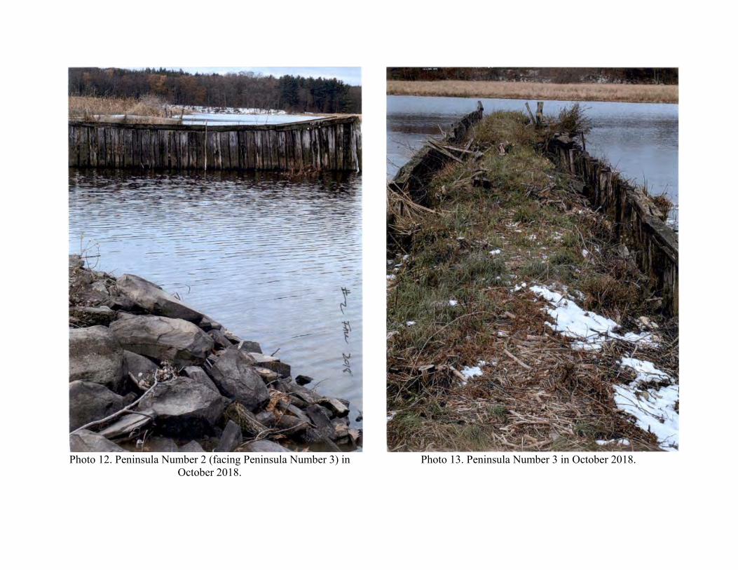
Photo 12. Peninsula Number 2 (facing Peninsula Number 3) in
October 2018.
Photo 13. Peninsula Number 3 in October 2018.

Photo 14. Peninsula Number 3 in October 2018.
Photo 15. Peninsula Number 3 in October 2018.

Photo 16. Peninsulas 1 and 3 in October 2018.
Photo 17. Boat ramp area between Peninsulas 2 and 3 in October 2018.

Photo 18. Peninsulas 1, 2, and 3 in June 2019.

Photo 19. Peninsula Number 1 in June 2019.
Photo 20. Peninsula Number 1 in June 2019.

Photo 21. Peninsula Number 1 in June 2019.
Photo 22. Peninsula Number 1 (facing Peninsula Number 3) in June 2019.

Photo 23. Bay between Peninsulas 1 and 3 in June 2019.
Photo 24. Peninsula Number 2 in June 2019.
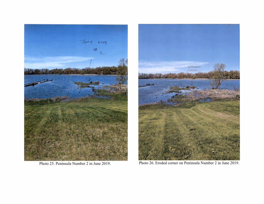
Photo 25. Peninsula Number 2 in June 2019.
Photo 26. Eroded corner on Peninsula Number 2 in June 2019.

Photo 27. Eroded corner on Peninsula Number 2 in June 2019.
Photo 28. Eroded corner on Peninsula Number 2 in June 2019.

Photo 29. Peninsula Number 2 in June 2019.
Photo 30. Peninsula Number 1 in August 2020.

Photo 31. Peninsula Number 2 in August 2020.
Photo 32. Peninsula Number 3 in August 2020.

Photo 33. Site overview in August 2020.
Photo 34. Peninsulas 1, 2, and 3 at low water in November 2020.

Photo 35. Bank of Peninsula Number 1 at low water in
November 2020.
Photo 36. Bank of Peninsula Number 1 at low water in
November 2020.

Photo 37. Bank of Peninsula Number 1 at low water in
November 2020.
Photo 38. Bank of Peninsula Number 2 at low water in
November 2020.

Photo 39. Bank of Peninsula Number 2 at low water in November 2020.

Photo 40. Peninsula Number 2 at low water in November 2020.
Photo 41. Peninsula Number 2 at low water in November 2020.

Photo 42. Bank of bay between Peninsulas 2 and 3 at low water
in November 2020.
Photo 43. Peninsula Number 3 at low water in November 2020.

Photo 44. Peninsula Number 3 at low water in November 2020.
Photo 45. Peninsula Number 3 at low water in November 2020.