an innovative pedagogical model for teaching with gis
TRANSCRIPT

GI Pedagogy Project https://www.gilearner.ugent.be/gi-pedagogy/ 2019-1-UK01-KA203-061576
1
GI-Pedagogy:InnovativePedagogiesforTeachingwithGeoinformation
REF.2019-1-BE02-KA201-060212
INTELLECTUALOUTPUT1
AnInnovativePedagogicalModelforTeachingwithGIS
ElaboratedbyEUROGEOwww.eurogeography.eu
FinalVersion:18November2020Contributedtobyallprojectpartners
Keywords:pedagogies,GIS,digitalcompetences,teachingandlearning,teachertrainingAbstract:Thisoutputconsistsofareview,analysisandevaluationofexisting,prevailingteachingpracticesthatincorporateGISinschoolsandanexplorationofevidencerelatedtoalternative,innovative,pedagogicalapproachestoteachingwithGIS.Asaresultofthereviewandanalysisoffindings,aseriesofrecommendationsareprovidedtoinformthedevelopmentoftheteacherprofessionaldevelopmentcourseandtoolkitofinnovativepedagogicalapproachestoteachingwithGISandconnecttothecasestudiesofoutcomes.ThisprojecthasbeenfundedwithsupportfromtheEuropeanCommission.Thisdocumentreflectstheviewsoftheauthors,andtheCommissioncannotbeheldresponsibleforanyusewhichmaybemadeof
theinformationcontainedtherein

GI Pedagogy Project https://www.gilearner.ugent.be/gi-pedagogy/ 2019-1-UK01-KA203-061576
2
TableofContents
1. THEGIPEDAGOGYPROJECT __________________________________________________________ 3 2. INTRODUCTION _____________________________________________________________________ 5 3. DIGITALCOMPETENCES ______________________________________________________________ 7 4. TEACHINGWITHGIS _________________________________________________________________ 9
4.1 INSTRUCTIONAL TECHNOLOGY _________________________________________________________ 10 4.2 E-LEARNING, FIELDWORK AND MOBILE GIS _________________________________________________ 11 4.3 WEB-BASED GIS __________________________________________________________________ 14 4.4 GEOMENTORING __________________________________________________________________ 15 4.5 PERSONALISED LEARNING ____________________________________________________________ 16 4.6 ROSENSHINE AND EFFECTIVE INSTRUCTION _________________________________________________ 18
5. APPROACHESTOTEACHINGWITHGIS ________________________________________________ 20 5.1 SPATIAL THINKING _________________________________________________________________ 20 5.2 GEOGRAPHICAL QUESTIONING, ENQUIRY AND SPATIAL REASONING _________________________________ 21 5.3 TPCK AND G-TPCK ________________________________________________________________ 24 5.4 THRESHOLD CONCEPTS AND POWERFUL KNOWLEDGE __________________________________________ 27 5.5 GEOMEDIA, SPATIAL CITIZENSHIP AND PARTICIPATORY GIS ______________________________________ 30
6. PEDAGOGIES _______________________________________________________________________ 33 6.1 CRITICAL SPATIAL THINKING ___________________________________________________________ 33 6.2 ACTIVE PEDAGOGIES AND ENQUIRY-BASED LEARNING __________________________________________ 35 6.3 PROBLEM-BASED LEARNING AND CONTEXT-BASED LEARNING _____________________________________ 38 6.4 PROJECT-BASED APPROACHES __________________________________________________________ 38 6.5 LEARNING PROGRESSIONS, TRAJECTORIES AND LEARNING LINES ___________________________________ 39 6.6 COGNITIVE LOAD THEORY ____________________________________________________________ 42
7 TRAININGTEACHERSFORGIS _______________________________________________________ 48 8 CONCLUSIONS ______________________________________________________________________ 53
8.1 RECOMMENDATIONS FOR GI PEDAGOGY _______________________________________________________ 53 REFERENCES ____________________________________________________________________________ 56

GI Pedagogy Project https://www.gilearner.ugent.be/gi-pedagogy/ 2019-1-UK01-KA203-061576
3
1. TheGIPedagogyProjectGI-Pedagogy(2019-2022)isaschooleducationprojectfundedundertheKA2cooperationforinnovationactionoftheErasmusPlusprogramme(EuropeanCommission,2019),thatseekstoconsolidateinacoherentconcept,structure,andsetofoutputs,thefollowingthreemajorelements,consideredkeyforintegratingtheuseofGISandspatiallearningatapan-Europeanscale:1)Theme:Theprojectfocusesdirectlyoninnovativepedagogyspecificallyappliedtonationalcurricula.ItrespondstotheneedtotrainteachershowtointegrateinnovativeGISciencepedagogyintotheirlessons.Itseekstodothisbydevelopingessentialteachertrainingresources.Theprojectintendstotransformexistingavailableknowledge,materials,concepts,andideasintorealtrainingofyoungteachers,withthefurtherpossibilityfortheprofessionaldevelopmentofexistingteachers.Todothis,GI-Pedagogybuildsonpreviousinnovativeworkandalsoincorporatesthelatestweb-basedtoolsandtechnologies.2)Tools,Data,andResources:GI-Pedagogyproposestotakeadvantageoftheexcitingandinnovativeworldofopendataandopenscience,thusofferingeasyaccesstosourcesforschoolsandconnectingtheschoolworldwiththerealworld(usingofficialdataandscientificresults)andraisingthepupils'awarenessofcitizenshipanddataissues.Theprojectwilltakeadvantageofthegrowingnumberofeasytouseweb-basedtechnologiesbecomingavailableonline.GI-PedagogywillusetheinnovativetechnologiesmadeavailablethroughtheEuropeanCommissionDigitalSkillsandJobsCoalitioninitiative(https://www.esri.com/en-us/school-program-europe/overview)andthepledgemadebytheleadingGISsoftwarecompanyESRItosupportschoolsacrossEurope(Esri,2016).3)GeographicFocusandPreviousInitiatives:SomematerialhasalreadybeenproducedtohelpteachGISinschools;however,ithasnotbeendirectedatinitialteachertraining,norhasitfocusedonnewteachers,withEuropeanrelevance.Additionally,theGI-PedagogyprojectwillbuildresourceswithaEuropeanfocusandrelatedtotheDigitalSkillsandJobspledge.ItbuildsonwhathasalreadybeenachievedbyvariousEuropeanprojects:- theHerodotThematicNetworkforGeography(2000-2009)broughtGIandspatialthinkingtothe
attentionofmany(Attard,2010;Donertand.Charzyński,2005).Asaresultofthisprojectmanyotherinitiativesweretaken,oneofthemleadingtotheiGuessproject,coordinatedinFlanders.
- TheiGuessproject(2007-2010)trainedteachersintheuseofGIS(Zwartjes,2009),andindevelopingtheirowndidacticalmaterialsusingGIS.Althoughverysuccessful(thereareongoingdisseminationactivities)thepartnersinvolvednoticedthatformanyteachersthelackofcurriculumguidance,includingmaterialsonGIScience,makesitdifficulttofullyintegrateGISineducation.
- Thedigital-earth.eunetwork(2009-2013)focusedonthedevelopmentofacommunityofgeomedialearners(Donert,2013;Lindner-FallyandZwartjes,2012;DeMiguelandDonert,2014),butthisonlyreachedaspecificgroupofteachers,educators,andthoseresponsibleforeducation.
- theGI-Learnerproject(2015-2018)createdaspatialthinkingcompetencemodel(Donertetal.,2016)andalearninglinewithready-to-uselessons(ZwartjesandLazaroyTorres,2019)forsecondaryschools.
- theMYGEOproject(2018-2021) aimsatfosteringtheemployabilityofstudentsinhighereducationthroughpromotingtheacquisitionofkeyskillsrelatedtotheuseofGeographicInformationSystems(GIS)tools.
4)EducationalMethods:IfwewanttobridgethechasmbetweentheearlyadoptersofGISandthewholeeducationalcommunity,theonlyeffectivestrategyistoexploreandencourageinnovativeapproaches

GI Pedagogy Project https://www.gilearner.ugent.be/gi-pedagogy/ 2019-1-UK01-KA203-061576
4
andfurthermoretoembedthemintheprocessofinitialteachertraining.PromotingstrongercoherenceinthecurriculausingGISisoneofthesteppingstonesthatwillallowmorepupilstoobtainjobsinthegrowinggeospatialindustry,whichhasbeenexpandingatmorethan12%perannumoverthepastdecadeandforecastsevenstrongergrowthintheyearstocome(GeoBuiz,2018)suchthateducationandtrainingcannotkeeppacewithdemand,leadingtoskillsshortagesandunfilledjobs.ThedevelopmentoftheGI-Pedagogyprojectwasderivedfrom:a)theresultsoftheSchoolontheCloud-ConnectingEducationtotheCloudforDigitalCitizenshipnetworkproject,whichexploredhoweducationshouldrespondtoCloudComputingdevelopmentsandhowCloud-basedservicescanbeusedtoimprovethequalityofeducationandtransformlearningandteachinginschools(KoutsopoulosandPapoutsis,2016);andb)theGI-Learnerproject,whichestablishedacompetencemodelandframework(Zwartjes,2018).TheseprojectsalsodemonstratedthatleadershipforchangeisneededasdescribedbyCamburnetal.(2013),asthemainissuetodayisnolongergettingaccesstotechnology,butthecapabilitytoestablishmeaningfulweb-basedlearningandteachingapproaches.TheGI-Pedagogyprojectaimstoexplorelearningandteachingbydevelopingtrainingandresourcesforgeographyteachers.Thehighest-prioritytargetgroupfortheresourcesarethosestillininitialteachertraining,NewlyQualifiedTeachers,andthoseintheirfirstfullyearofteaching,whoaccordingtoChristensenandKnezek(2017)areintheprocessoftransitioningbetweeneducationalenvironments-acriticalstagefortechnologyintegration.

GI Pedagogy Project https://www.gilearner.ugent.be/gi-pedagogy/ 2019-1-UK01-KA203-061576
5
2. IntroductionGeographicInformationSystems(GIS)areaninnovativetechnologythatusesCloudComputingtodeliverawidevarietyofdifferentITservicesrelatedtogeospatialinformation,data,andevenmultimedia(Luetal.,2019).TheCloudhasbecomeaubiquitoustoolenablingdigitaladministrativeandoperationalsystemswhichcanbeestablishedandusedinreal-time.Theuseofweb-basedapplicationsonmobiledevicesisexpanding,andincludesservicessuchasemail,informationstorage,filesharing,collaborativetools,digitalcommunication,andotherservices.Basedonrecentlypublishedguidance(EducationEndowmentFoundation,2019),thequestionhasshiftedfromwhetherornottechnologyhasaplaceintheclassroomtohowtechnologycanbeintegratedintothecurriculumandespeciallyintoteachertraining(Curtis,2019;Hohnleetal.,2016)andensurethatthosetrainedtoteachpupilsrecognisetheimportanceofweb-basedservicesinthewiderworldandineconomicandsocialactivities.Technologicaladvanceshaveresultedinnewparadigmsandincreasinglypowerfultoolsforexploringspatialrelationships,butmuchlessattentionhasbeendirectedatmethodsandstrategiesusedtoteach.
“theprocessofacquiringknowledgeandskillswithinlearningprocessesshouldnotproducepassiveknowledgeandisolatedskillsandabilities,butshouldinsteadresultinapplicableknowledgeandintegratedskillsandabilitiesinareal-worldcontext”(HartigandKlieme,2007,p.13).
Petrasetal.(2015)describetheuseoffreeandopensourcesoftware,whichhasbeenconsideredahighpriority(andoftenstatedasmandatorybyfundingagencies),asitisfullytransparentandmoreaccessibleforinstitutions,individualstudentsandscientists.Opensoftware,opendata,openstandardsandopeneducationarethekeycomponentsoftheopenGISframework.Theysuggesttheapplicationofgeospatialconceptsshouldbeemphasizedineducationmuchmorethansoftware-specifictasks.Ifteachersunderstandnotonlytheimplementation,butalsotheunderlyingscienceandtechnology,thentheywillbeabletodevelopbetterandmoreflexiblelearningsolutions.Web-basedGISisaverypractical,active,andrelevantwayofincludingdigitaltechnologyinschooleducationandteachertraining(HongandStonier2015),howeverastechnologyadvancesitmakesdecisionsaboutwhenandhowtodothisincreasinglyharder.PreviousEuropeangeotechnologyeducationprojectshaddemonstratedthatthemostchallengingperiodfortechnologyintegrationisgettingteacherstorecognisethevalueofthetoolssotheyarepreparedtoaddresstheclassroomissues.Ithasbeenshownthattrainingiscritical(ZwartjesandLazaroyTorres,2019)sothatteachersareabletodevelopbasicskillsandcompetenciesinGISandasoundframeworkforinvolvingtechnologyuseintheirclassroomsandwithpupils.MathewsandWikle(2019)dealwithteachingaboutGIStechnologyanditsapplicationsinhighereducation.TheEuropeanCommissionacknowledgesthatEuropemustbecomemuchmore"Cloudactive"tostaycompetitiveintheglobaleconomy,andhastackledmajorbarrierssurroundinglegalissues,datasecurityandcopyright.Schoollearnerexpectationsarealsochanging.Learnersrequirereadyaccesstorelevantonlinetoolsandcontent,aswellassecure,reliablenetworkswhichcanoffertheabilitytocreateandsharecontentonanynumberofdevices.AppliedcomputersystemslikeWeb-basedGISprovideaquick,reliable,24/7service,whichconformstothisnewanddifferentservicemodel(DeMiguelGonzálezandDeLázaroTorres,2020).TheadoptionofGISinschooleducationremainsfragmented(JacksonandKibetu,2019)becausewhileCloudComputingoffersmanyadvantages,teachersarelargelyunawareofthegreatneedsoftheindustryandthepotentialbenefitsforlearningandteaching.Improvedtrainingandenhancedsupportsystems/

GI Pedagogy Project https://www.gilearner.ugent.be/gi-pedagogy/ 2019-1-UK01-KA203-061576
6
pedagogicaltoolsareneededtohelpnewteachersintegratetherapidlyevolvingCloudComputingGISenvironmentintotheclassroom(Mitchelletal.,2018).Innovativepedagogicalchangeisneededinteachereducation,otherwiseeducatorswillcontinuetheparadoxofusingoldteachingmethodsbutwithnewtools.LittleresearchhasbeenundertakendemonstratingtheintegrationofGISandgeospatialapplicationsintotheschoolcurriculum.RoosaareandLiiber(2013)introducedamodelofhowtonationallyintegrategeo-mediaandGISintogeneralsecondaryschooleducation,wheregeoinformaticswasdevelopedasanelectivecourseforpupilsatsecondaryschoollevelinEstonia.Thiscoursehasbeenusedasanopportunitytoapplytheuseofgeo-mediatools,emphasizeICTskillsandstudents’geospatialthinkingskills.Bakeretal.(2015)commentthatresearchinGISeducationseemstohavehadlimitedimpact.Ithaslargelyfocusedontheeducationalandtechnicalchallengesthathaveaffecteditsimplementationinformalandinformallearningenvironments.Bednarz(2004)suggeststhishasbyandlargerelatedtocomputerspeedandcapacity;softwareuseandcomplexity;shortagesofresourcesandlessons,linkstocurriculumandstandards;administrativeandtechnicalsupport;andtimerequiredtoimplementGIS-basedmethods.Rickles,EllulandHacklay(2017)focusontheresultsofasurveyonresourcesandplatformsusedintheinterdisciplinaryteachingofGISandthenexploringpossibleconstructivistlearningtheories.Theyproposedaframeworktoactastheeducation-basedstructureforwhichGISconceptscanfocusonanddefineinterdisciplinarityas“betweendisciplines”,suggestingthebasicelementsofatleasttwocollaborators,atleasttwodisciplines,andacommitmenttoworktogetherinsomefashioninsomedomainarenecessary.However,theintroductionoftechnologyintocurriculumisfurthercomplicatedbyspeedofchange,varietyanddiversityofcontexts.AccordingtoStringeretal.(2019),integratingtechnologyintotheclassroomtoimprovelearningrequiresaddressingbothpedagogyandimplementation.

GI Pedagogy Project https://www.gilearner.ugent.be/gi-pedagogy/ 2019-1-UK01-KA203-061576
7
3. DigitalcompetencesInteachereducation,professionalcompetencesdependonsubject-specificknowledgeandskillsinspecificpedagogicaldomains.ThecompetencesserveasabasisfortheimplementationofaneducationalapproachtothepracticeofteachingandlearningandaccordingtoSchultzetal.(2012)relatesstronglytocurriculumdevelopment.Digitalcompetencesareakeytransversalcompetence,thatcitizensincreasinglyneedtoacquire.Theyareconsideredtobeanecessitytoachievingadegreeofliteracysuitedtopresent-daysociety’sneeds.DigiCompistheEuropeanCommissionframeworkdesignedtosupportanunderstandingofdigitalcompetence.Itincludesissuessuchasinformationstorage,digitalidentity,developingdigitalcontentandbehaviouronline,ineverydaylifesuchasworking,shoppingandparticipatinginsociety.Kluzeretal.(2018)provideauserguidewithabroadrangeofexamplesfromthosewhousetheDigCompframework.
ADigCompEduFrameworkhasbeendevelopedtosupporttheteachingprofessioninallsectorsofeducation.Itimpliesbeingabletousedigitaltechnologiesinacritical,collaborativeandcreativeway.DIgiCompEduconcernstheuseandtransmissionofeducator-specificdigitalcompetencesforuseinschoolandtheclassroom(Rubioetal.,2019).DigiCompEduproposes22elementarycompetencesorganisedin6areas(Figure1).Area1isconcernedwiththeuseofdigitaltechnologiesinprofessionalinteractions.Area2looksatthecompetencesneededtoeffectivelyandresponsiblyuse,createandsharedigitalresourcesforlearning.Area3isdedicatedtomanagingandorchestratingtheuseofdigitaltechnologiesinteachingandlearning.Area4addressestheuseofdigitalstrategiestoenhanceassessment.Area5focusesonthepotentialofdigitaltechnologiesforlearner-centredstrategiesandArea6detailsthespecificpedagogiccompetencesrequiredtofacilitatestudents’digitalcompetences.
Figure1:TheEuropeanDigiCompEduframeworkforteachers(Vuorikarietal,2017)
TheFrameworkoutlinessixdifferentstagesthroughwhichaneducator’sdigitalcompetencetypicallydevelops,soastohelpeducatorsidentifyanddecideonthespecificstepstotaketoboosttheir

GI Pedagogy Project https://www.gilearner.ugent.be/gi-pedagogy/ 2019-1-UK01-KA203-061576
8
competenceatthestagetheyare.Inthehigheststages,called‘Leader’and‘Pioneer’,theteachersareabletopassontheirknowledge,critiqueexistingpracticeanddeveloptheirownnewpractices.
Schultzetal.(2013)commentonthreecorecompetencesfoundationaltoworkingwithGIS:GIS-relatedknowledgeandskills,spatialthinking,andproblem-solvingskills”(Schultzetal.,2013).Jakabetal.(2016)describedhowthestrongcross-disciplinarycharacterofGISrequirestheapplicationofwiderangeofkeycompetencesthathelpteachersshapeanddeveloptheirprofessionalidentity.Bearmanetal.(2016)notedhowmuchtrainingtendstobebasedondevelopingGISskills,ratherthanonspatialproblems,orunderstandingtheusefulnessofdata,ortheneedsofthelearners.Asaresultofthisfocusonthetechnology,coursesattractteacherswhoaremoretechnologicallyableanddigitallyliteratethanthosewhoarenot.Thisrelatedtotechnicalcompetencesratherthancriticalspatialthinking.
AspartoftheGI-LearnerProject,Donertetal.(2016)proposedasetofspatialthinkingcompetencesforpupilsbasedonspatialthinking,wherespatialthinkingisadistinctformofthinking,whichhelpspeopletovisualizerelationshipsbetweenandamongspatialphenomena(StoltmanandDeChano,2003),theseweredescribedasto:
1. Criticallyreadandinterpretcartographicandothervisualizationsindifferentmedia2. BeawareofgeographicinformationanditsrepresentationthroughGIandGIS3. Visuallycommunicategeographicinformation4. DescribeanduseexamplesofGIapplicationsindailylifeandinsociety5. Use(freelyavailable)GIinterfaces6. Carryoutown(primary)datacapture7. Beabletoidentifyandevaluate(secondary)data8. Examineinter-relationships9. Synthesisemeaningfromanalysis10. Reflect,andactonthebasisofknowledge.
Theyhavebeenusedtocreatelearningprogressionobjectivesthatteacherswouldtranslateintolearningobjectives,teachingandlearningmaterialsforthewholecurriculum(K7toK12)thusincreasingspatialthinkingeducationactivitiesforhighschoolpupils(Zwartjes,2018).

GI Pedagogy Project https://www.gilearner.ugent.be/gi-pedagogy/ 2019-1-UK01-KA203-061576
9
4. TeachingwithGISDonertetal.(2016)defineanddescribeTeachingwithGISasacomplexcontextofgeospatialthinkingandgeospatiallearning,exploringtheintegrationofspatialliteracy,spatialthinkingandGIScienceintoschoolsasanoutcomeproposedintheKA2ErasmusPlusGI-Learnerproject.RoosaareandLiiber(2013)suggestthereisconsiderablediversityinunderstandingwithregardtowhat,whenandhowtoteachwithGISingeographyeducation.AccordingtoFavierandvanderSchee(2014),itisnotthetechnologyitselfthatproduceslearning,butthecomplexwholeofclearandappropriatelearninggoals,solideducationaltechnologies,well-designedtasks,andhigh-qualityinstruction,coaching,andreflectionprovidedbytheteacher.Kerskietal(2013)analysethestatusofGISinschoolsinthirty-threecountriesandproposesrecommendationsforadvancingtheimplementationandeffectivenessofGISinsecondaryeducation.TheirstudyrevealedthatuseofGISinsecondaryeducationremainedsmall;howevertheysuggesttheconvergenceofcitizenscience,anemphasisonspatialthinking,mobiledevices,opendata,andWeb-basedmapservicescouldcauseasignificantincreaseinthenumbersofschools,educators,andstudentsteachingandlearningwithGIS.Despitehardwareandsoftwarechallengesrepeatedlymentionedbyeducators,societalissuesappeartocastthegreatestconstraintonGISbecominganembedded,requiredtoolthroughouteducation.Ofmajorimportanceseemedtobethelackofawarenessofspatialthinkingandanalysisandtheirimportanceineducationandsociety.Favier(2013)presentsaschematicviewof5waystodealwithgeoinformationtechnology(Figure2).TeachingandlearningaboutGISfocusesmoreonthetheoreticalaspectsofGIS(knowledgeofGIS,structureofthetechnology),whereastheotherwaysusethetechnologytodevelopandusespatialthinkingskills.Hesuggestsgeographyeducatorshavepredominantlyfocusedonusinggeoinformationtechnologytolearnsubjectknowledgeanddomain-specificskills,ratherthanfocusingonlearningtousethesoftware.However,ifgeo-informationtechnologyisappliedinlessonsinwhichstudentssitbehindthecomputerandareactivelyinvolvedwiththetechnology,youcannotavoidteachingthemfirstaboutthecharacteristicsofdigitalgeoinformationandhowthetechnologyworks.Hesuggestsitthereforemakessensetostartbyusingweb-basedGISandvirtualglobeslessons,followedbylessonswithdesktopGIS,andfinallyapplyGISinsmallpracticalassignments.Thiswouldbeaniceelaborationforalearningtrackfor(geography)educationwithgeo-informationtechnology.
Figure2:FivewaysofintegratingGISingeographyeducation(Favier,2013)

GI Pedagogy Project https://www.gilearner.ugent.be/gi-pedagogy/ 2019-1-UK01-KA203-061576
10
4.1InstructionalTechnologyInstructionaltechnology,oftenusedinterchangeablywiththetermeducationaltechnology,isaspecifictechnologyfieldthatdealswithcreatingresourcestosupportlearning(Caldwell,2019).ColvinandTomayko(2015)suggestteacherstodayneedtomasterinstructionaltechnologytopreparelearnersforahigh-techandincreasinglyinterdependentworldwhereprofessionaltoolsareintegratedintotheclassroom.Stringeretal.(2019)consideredhowtechnologycanimproveteachingandlearning,througha4-stageimplementationprogressprocess(Figure3)summarisinghowimplementationoftechnologyinlearningandteachingcanbedescribedasaseriesofstagesrelatingtothinkingabout,preparingfor,delivering,andthensustainingchange.Consideringtheimpacttoconsiderwhetheritcansupplement,enhanceorreplaceexistingteaching.
Figure3:TheImplementationProgressProcess
RecentresearchbyMayer(2019)lookedatthepotentialofmultimediainstructiontoimprovelearningintheclassroom,whereresearchevidenceshowsthatpeoplelearnmorewhenimagesareaddedtotextastheyworktogethertopresentaninstructionalmessagewhichleadstoadeeperunderstanding,thanwordsontheirown,whetheritispresentedinabookoronacomputer.Theuseofpicturescanincludestaticphotos,charts,graphicsandillustrationsordynamicvideosandanimations,andwordscanbeeitherspokenorprinted.AccordingtoMayer,thiscognitivetheoryisbasedon3keyideasfromcognitivescience,thedual-channelprinciplewhereverbalandpictorialinformationprocessingisseparate(Baddeley,1992),thelimitedcapacityprinciple:whichmeansonlyafewitemscanbeprocessedatatime(ibid)andtheactiveprocessingprinciple:whichmeansthatmeaningfullearningneedstobecoherently

GI Pedagogy Project https://www.gilearner.ugent.be/gi-pedagogy/ 2019-1-UK01-KA203-061576
11
organisedandintegratedwithpriorknowledge,sothatrelevantwordsandimagescanbeselectedfromtheworkingmemory,toguidethelearner’scognitiveprocessing.(Mayer2009)Mayer(2019)proposesthatinmultimediainstruction,theworkingmemorymentallyorganisesthewordsintoaverbalmodelandtheimagesintoapictorialmodel,whichcombinewithpriorknowledge,makingsureworkingmemorydoesnotbecomeoverloaded.Asetof11evidence-basedprinciplesformultimediadesignarepresentedthatincreasestudentlearning(Table1).Table1:DesignformultimediainstructionExtraneousprocessing–cognitiveprocessingthatdoesnotsupportinstructionalgoals–i.e.unnecessary- Coherence–keepinstructionalmessagesimple,avoidunnecessarydetail- Signalling–highlightessentialmaterial- Spatialcontinuity–integratetextwithrelevantpartofgraphics- Temporalcontinuity–presentspokenwordsimultaneouslyasgraphics,drawingoranimations- Redundancy–donotduplicatenarratedgraphicswithprintedtextaswell.Manageessentialprocessing- Segmenting–breakdownlearningintoparts- Pretraining–teachanoverviewofkeyelementsandwordsbeforeintroducingthediagramdetails- Modality–spokenwordsupportsmorelearningthanifthewordsareprintedEncouragegenerativeprocessing- Personalisation–usinginformalconversationtopresentinformation- Voice–usingahumansoundingvoiceratherthanamachine- Embodiment–includehumanlikegesturesonthescreenAlibrandiandPalmer-Moloney(2001)confirmedthatasatechnology,GISoffersnewwaysofviewing,representingandanalysinginformationfortransformativelearningandteaching,howeveritsusemeanssteppingintotheunknown,takingrisks,creatingpathwaysandexperimenting.Baker(2005)notedtheemergenceofGISasaninstructionaltechnologyforsupportingcontextuallyrichstudentlearningintheK12curriculum.FaginandWikle(2011)commentedthatteachersusingGISbefittedfromsignificantadvancesininstructionaltechnology.
4.2 e-learning,fieldworkandmobileGISE-learningisasetofmodels,technologiesandprocessesfortheacquisitionanduseofknowledgethroughtheuseofinformationandcomputertechnologies.IthaspredominantlybeenusedforteachingwithGISbyincorporatinganumberofgeospatialtoolsandtechniques.IntheirpaperKarolčíketal.(2019)analyseane-learningenvironmentforGeographyinordertoimplementpersonalizedactivelearninginGeographyteachingandlearning.TherequirementsofanadaptivetoolforGeographyteachingandlearningarediscussedandatheoreticalframeworkforpersonalizede-learningenvironmentisproposed.ICTcanbeusedasaresearchtooltohelpstudentsapprehendnotionsandanalyseinformation.Thisallowsaseriesofquestionssuchas:where?what?andorganizationalaspectssuchaswhy?how?andrelationshipstotakeplace.Thechallengeofadidacticprocessistoorganizeandsupportstudents’questions.Thus,accordingtoZwartjesetal.(2015)thereisaneedtomodeltheprocessingofinformationinaneducationalcontextin4steps,theproblem,dataresearch,buildinganargumentandproducingresultsand.Bearmanetal.(2016)suggestthepresenceofane-learningenvironmentisimportantbecauseithelpsstudentstobeabletoaccessandmakesenseof(geo)information.TheysuggestGIShasbeenheldbackbecauseofanemphasisonthetechnologyratherthanthespatialdatahighlightingthefocusonITskillsratherthanspatialliteracy.Asaresult,studentswillnotbetaughttheskillstheyneedtobeabletocriticallyinterpretmapsanddata.TheyalsoconsiderthatpracticaltechnicalsessionsdominatedinGIS

GI Pedagogy Project https://www.gilearner.ugent.be/gi-pedagogy/ 2019-1-UK01-KA203-061576
12
curricula.Inpedagogicalterms,thestudentwasoftengivenadata-setandgiveninstructionsonhowtousetheGIStoprocessthedatatogetthefinalanalysisoutput.Thisapproachdevelopsthestudent’sabilitytousethesoftwareinquestion,butitdidnotaddmuchtotheirknowledgeaboutthetypesofquestionthataGIScananswer.GISanalysisandGISoutputweremucheasiertousethancompletingthewholeproblem-solvingprocess.RoosaareandLiiber(2013)reportonthedevelopmentofaweb-based(Moodle)electivecourseopensthedoorforflexibleandindividualizedteaching/learningsolutions.TheauthorsalsoreportonthelessonslearnedfromtheGeo-Olympiadwhere,since2005,computer-basedexercisesandGIShavebeenincludedinthewrittentasksforsecondaryschools.Studentshavetofind,interpretandanalysesomegeographicalinformationfromInternetportalsandproblem-solvereallifeproblems.AccordingtoFeddernetal.(2018)learningsoftwarehasbeendevelopedtosupportindependentlearning,basedontechniquesofretrieval,interleaving,spacingandvisualcues,whichtheytestedasrandomisedcontroltrialwithschoolpupils.Theirindependentlearningplatformwascapableofbeingusedwithavarietyofcontentyetnotneedingmuchstafftraining.Themoduleswhichintroducematerialorteststudentsareshort,anduseanalgorithmtointerleaveandspacelearningusingamixtureoftext,imagesanddifferenttypesofquestions,whicharedesignedtopromoteretrievalpractice.Grunwaldetal.(2005)reportontheconstructionofavirtualmodularlearningenvironmentbasedontheconceptofReusableLearningObjectsinordertoevaluatetheefficacyofdifferente-learningtoolsforon-campus(OC)anddistanceeducation(DE)studentsincontextoflearningoutcomes.TheyconcludedthatavirtualGIScoursehasthepotentialtogenerateequallearningoutcomescomparabletoon-campusGIScoursesprovidedstudentsareself-motivatedtostudythecoursematerialandcapableofmanagingtheirtimeappropriately/effectively.Belgiuetal.(2015)evaluateopeneducationinitiativesinthegeospatialdomainandtheMOOCmovement.ThearticlefocusesonWeb-basedtechnologies,fosteringonlinecoursesandprograms.OpenEducationalResources(OER)havebecomethenormasOERimplylegallyopencontentlicensingunderaCreativeCommons(CC)license.TheuseofMOOCs(MassiveOpenOnlineCourses)havebecomeapopularopeneducationmodelforhighereducation.Caeiroetal(2011)evaluatedtheeffectivenessoftheuseofvideosinthestudentslearningoutcomesinaGISe-learningcourse.Thehighereducationstudentswereguidedbyacurricularunitplan,digitalresources,formativeactivitiesandacontinuousassessment.Thevideoseffectivenesswasassessedbyanalysingstudentswrittenassignments(e-folios).TheirresearchconfirmedthatvideoshavethepotentialtobeusedasanimportanttoolinGIS-educationinane-learningsystem,astheyareavisualmediumwiththepotentialtosupportlearningindifferentwaysthanothertechnologiesdo,includingthepotentialfordemonstrationsandthroughtheuseofscreen-capturetechnology.MichelandHof(2013)wereconcernedwithtakinge-learningandGISintothefield.Theyexploretheuseofmobileandspatially-enableddevicesinthefieldandthecombinationofadventureandmediapedagogywithmultimediaenvironmentaleducation.Theyconsiderhowlearningresourcesandoutdooractivitiesarecombinedtogetoriginalnatureexperienceswithitsvariedspatialandtemporaldimensions.Theauthorsprovidetheconceptualizationofagame-basedapproachcalledtheeGeo-Riddle(Figure4).

GI Pedagogy Project https://www.gilearner.ugent.be/gi-pedagogy/ 2019-1-UK01-KA203-061576
13
Figure4:TheeGeoRiddleapproach
Themobilefieldtripwasbasedonthreelearningunits,amultimediaintroductionwithbackgroundinformationforknowledgetransfer;theeGeo-Riddlewithinteractiveexercisesandriddlesinthefield;andthesolutionandevaluationstationforpostprocessingandknowledgeconsolidation.Withinthisframework,thefieldtrippromotesspatialreasoningandinterpretation,whichinvitesstudentstodetectandmapdifferenttypesandstructuresinaninteractivemap.Butmoreimportantlythestudents,bygoingoutside,willmaketheirownobservationsandcollectsamples,andareconsequentlypracticallyandtheoreticallytrainedinthinkingwithandaboutspaceaswellasacquiringatangibleimaginationofspatialcharacteristicsanddifferences.Fieldworkisanintegralpartofeducationindisciplineswithastrongspatialcomponent.Kolvoordetal.,(2019)saythattheincreasingimportanceofdataandgeospatialtechnologiessupportseducationinitiativesthatteachGIShands-onandapplyingittolocalproblems.GISisthereforevaluableforeducationsinceitcanhelpstudentstoidentifyandanalysespatialpatterns.DeLázaroyTorresetal.(2016)suggestedthatoutdoorlearningingeography,usingmobiledevicesandassociatedspatialthinkingwillservestudentswellforemployment.PánekandGlass(2018)appliedmobileGISmethodsinfieldworksituationswherestudents’workincludedtheaccumulationandevaluationofdifferenttypesofdatatoconstructasenseoftheplacetheywerestudying.Theysuggestedstudentsneededtolearnhowtoengagewithaneighbourhoodinwaystomakemeaningofthedifferentlayersofhistoryoftheresearchsite.LambrinosandAsiklari(2014)createdafieldtriptreasurehuntusingacompass,GPSandGISgeneratedmapswityoungpupilsfromtheageof10.Theysuggestthattechnologyapplications,likeGISandGPS,canbeeasierimplementedthroughinterdisciplinarysubjects.Brooks(2018)describestheprocessesanddecisionsmadeinthedevelopmentofamobilelearningapplication.TheintendedusersofthisapplicationwereadultlearnerswhowanttolearnaboutGISconceptsandskills.Hesuggestsanactivepedagogyshouldinvolve“kinaestheticactivities,theconscious

GI Pedagogy Project https://www.gilearner.ugent.be/gi-pedagogy/ 2019-1-UK01-KA203-061576
14
analysisofspatialdata,andreflectiononlearning”.Buildingactivelearningintothecurriculumcanbringmanybenefits,includingtheclaimthatstudentslearnmorethroughthemetacognitionprovidedthroughactivelearningandthatstudentslearnmoreovertraditionallecturingmethods.Theapplicationdescribedinthisthesisessentiallyutilizesmapmashupswherestudentscaninteractwithlayers,features,attributes,analysistools,andotherGIS&Tfunctionstolearnthelessonconcept.Incorporatingthesemashupsascorecomponentsofthelessonsandavoidinghighlystructuredexercises,allowsgreaterflexibilityandpersonalizationofcontent,whichisoneofthemajoradvantagesofmapmashups.MichelandHof(2013)warnhowever,thatinspiteoftheimportanceoflocation-basedlearningandtherequirementofstudentsformorepracticalexamples,thequantityofdaysforfieldvisitsandpracticalfieldworkarebeingreduced.Totacklethisseverale-learningcoursesontheinternetaswellasawiderangeofGPS-basedlearningandadventureopportunitieshavebeenestablishedinrecentyears.
4.3 Web-basedGISTheinternetisbecomingmoreandmoreimportantfortheprovision,transferandanalysisofgeodata.Asaresult,GISfeaturesarebeingintegratedandimplementedinweb-basedinformationsystems.TheseareWeb-basedgeographicinformationsystemsorWeb-basedGIS.Theenormousincreaseinthenumberofweb-basedapplicationsthatusetechniquesderivedfromgeographicinformationsystems(GIS)isbasedonthedemandforthevisualisationofgeographicdataontheWeb.Inordertoexaminethepotentialassociatedwiththeuseofweb-basedGISingeographyclasses,Arslan(2015)analysestheusabilityandstudentlearningoutcomesofusingdesktopandWeb-basedGISsoftwarewithschools(Figure5).
Figure5:CriteriausedtoanalyseWeb-basedGISplatforms(Arslan,2015)
Web-basedGIS,primarily,wasseentohaveapositiveimpactonstudentachievement.Therealpotentialofweb-basedGISforgeographycoursescanbeunderstoodbetterwhenconsideringotherbenefitsthat

GI Pedagogy Project https://www.gilearner.ugent.be/gi-pedagogy/ 2019-1-UK01-KA203-061576
15
web-basedplatformprovidedforstudents,courseandteachers.Thecoursewasstudent-centered,therewasevidenceofmanyskillsbeingdeveloped,suchasspatialanalysis,spatialthinking,findingcause-effectrelation,queryingandcreatingquestions.Web-basedGISwasaneffectiveteachingtool,easilyusedbyteachersintheircourseswithouttechnicalissues.Studentsconsideredittobeaneffectivelearningtool,helpthemtograspideaseasily.MilsonandEarle(2008)exploredtheuseofInternet-basedGISasatoolforintegratinggeospatialtechnologiesinninth-gradegeographycurriculumandinstructionwithinaninductivelearningenvironment.Thestudyfindingsindicatedthatstudentswereabletoaccessandmakeuseofgeospatialdatatoconstructtheirunderstandingofgeography.KerskiandBaker(2019)suggestthatusingaWeb-basedGISsystemimpliesachangeinhowGISareperceivedandtaught.Fargher(2018)arguesthatbydrawingonaGeoCapabilitiesapproachtheteacher’suseofWebGIScanbeenhancedindeepeningtheirstudents’abilitiestothinkandreasonwithgeographicalknowledgeandideas.FundamentaltoGeoCapabilitiesthinkingisanemphasisonaprogressive,subject-ledapproachtoteachingschoolgeographyparticularlythroughthedevelopmentofpowerfuldisciplinaryknowledge(PDK),schoolsubjectknowledgecanonlybepowerfulwhenitenablesyoungpeopletothinkinwaysbeyondtheirdirectexperience(Figure6).
Figure6:AtypologyofGeography’spowerfulknowledge
GeoCapabilitiesadoptsanapproachunderpinnedbythebeliefthatknowledgedevelopmentinschoolsshouldbeledbysubjectspecialistswhoarebestplacedtoprovideyoungpeoplewiththehighestqualitygeographyeducation.
4.4 GeoMentoring

GI Pedagogy Project https://www.gilearner.ugent.be/gi-pedagogy/ 2019-1-UK01-KA203-061576
16
IntheUSA,theGeoMentorprogramme(http://www.geomentors.net),establishedbyEsriandtheAmericanAssociationofGeographers,bringstogetherpeople(experts)whoarewillingtohelpwiththedeploymentofGISintoteaching.(DeMers,2016)suggestsprofessionalGISmentoringofeducatorsrapidlyimprovesthelikelihoodthatGISwillreachtheelementaryandsecondaryteachers.Healeyetal.(2018)reportonaprogrammetosupportteachersinintroducingWeb-basedGISinschoolsintheUK.TohelptheeffectiveuseofArcGISOnlineinclassrooms,adedicatededucationalteam–includingaformerclassroomteacher—and300professionalGISusersregisteredasvolunteerGeoMentors.TheseindustryexpertsgivetheirtimetoschoolstosupporttheiruseofGIS.TheyhelpteachersgetfamiliarwiththeArcGISOnlineplatform,createnewresourcesincollaborationwithstaff,andinspirestudentstopursuetheirowncareersinGISbytalkingabouttheirexperiences.HealeyandWalshe(2019)focusonhowlearningfromreal-worldgeographersincludingindustryexpertsbothfromlocalcontextsandfromtheGeoMentorsnetworksetupbyEsriUKabouttheGIStheyuseintheireverydayjobscanengagestudents.HealeyandWalshe(2020)exploretheuseofGISinUKschoolsinthecontextofschoolanduniversitycrossover.Theauthorsareparticularlyinterestedintheconnectionwithcurriculumthinking.TheyreportareluctanceamongstteacherstoengagewithGIS,andexploredtheuseofreal-worldexpertstoinfluencestudentperceptionsoftherelevanceofGISandreal-worldapplicationswhichtheninfluencessubsequentacquisitionofstudentknowledge.AlongitudinalstudyexplorestheUKGeoMentorsschemeofESRI/RGS-IBGwhichfocusesonhowtappingintotheexpertiseofreal-world,industryexpertsandthewaysitcanaffectstudents’perceptionsoftherelevanceofGIStogeographyandsupporttheiracquisitionofgeographicalknowledge.Theirresultssuggestthatengagementwithindustryexpertsincreasesstudents’understandingofwhatGISis,allowingthemtodevelopamorenuancedappreciationofitsreal-worldapplications;thisthenappearstoplaybothadirectandindirectroleinthesubsequentdevelopmentofstudents’geographicalknowledge.
4.5 Personalisedlearning
Aseducationiscurrentlyundergoingsignificantchangebroughtaboutbyemergingreforminpedagogyandtechnology,effortshavesoughttoclosethegapbetweentechnologiesaseducationaladditivetoeffectiveintegrationasameanstopromoteandcultivatestudentcentred,inquirybasedandproject-basedlearning.GIShasbecomestronglypersonalisedaslocation-awareservices,personaliseduserinterfacesandaccessiblemobilecommunicationhaveevolved.PersonalisedGISdevelopmenthasbeenreportedinmanydiversefieldsforinstanceintourism(Posladetal.,2001),communitymapping(Ardissonoetal,2017),heritageinformation(MacAoidhetal.,2006),education(deLázaroetal.,2017)and3Dnavigation(Doulamisetal.,2013).Ineducation,personalisationinGISlookstointegratestudentsintheirenvironmentandenhancetheirunderstanding.Althoughtherearedifferencesindefiningpersonalizedlearning,alldefinitionsandresearchagreesontheseprinciples:- Personalizedlearningstartswiththelearnerandthelearnerisinthecentre- Thelearnerisactiveindesigningtheirlearninggoalsandprocesses- Thelearnerdecideshowtoaccessandacquireinformation,- Thelearnerownsandtakesresponsibilityoflearning,thusmoremotivatedandengagedinthe
learningprocess,- Thelearnerownsthecapacityforcriticalmonitoringoflearningoutcomes- Highqualityteachingresponsivetothedifferentwaysstudentsachievetheirbest- Creatinganeducationpaththattakesaccountoflearner’sneeds,interestsandaspirations

GI Pedagogy Project https://www.gilearner.ugent.be/gi-pedagogy/ 2019-1-UK01-KA203-061576
17
- Makingastrongcontributiontoequityandsocialjustice(Zwartjesetal.,2015).Personalisedlearningdescribessituationswherelearningwascustomisedforthepreferencesandabilitiesofindividuallearnersorgroupsoflearners.Itshiftstheroleofstudentsfrombeingsimplyaconsumerofeducationtoaco-producerandcreatoroftheirownlearningpathwayactivelyengagesstudentsintheprocessoflearning(Bartle,2015).Fromtheteachers’perspective,issaidtobeathree-partprocess,whichincludesplanningthatpromotesdeeperstudentlearning;understandingofeachstudent’slearningneedsandinterests;andprovisioningofappropriatelearningexperiencesthatmatcheachstudent’suniquelearningprofile. PersonaliseddigitallearningenvironmentsareusuallyWeb-basedsystemsandoftenutilisemobiledevicesofferingauniqueandpersonalplatformfordevelopinglearner-centrededucationalexperiencesthattoenhancestudents’learningengagementviapersonalisedinformationandservices(Masselenoetal.,2018).Personalisedlearningenvironmentsplacethestudentintoamorecentralandactiveroleintheirownlearning,wherelearnerscanaccessrelevantandcontextualinformationbasedontheirdifferenttasksandneeds.Learnerscanlearnfromthematerialsprovidedbylearningsystemsbasedontheirownlearningpaceandpreference.Thisencourageslearners’empowermenttowardstheirownlearningprocessandprogress.ThePersonalisedLearningEnvironmentconceptplacesthefocusontheappropriationofdifferenttoolsandresourcesbythelearner,wherebythelearnerissituatedwithinasocialcontextwhichinfluencesthewayinwhichtheyusemedia,participateinactivitiesandengageincommunities.TheperspectiveisthebasictheoremoftheActivityTheory(Engeström2001).Theactivitytrianglemodelrepresentinganactivitysystemcombinesthevariouscomponentsintoaunifiedwhole.Fromthisperspective,focusingonthethreeaspects–personal(‘subject’),learning(‘tools)andenvironment(‘object’)–meansdisregardingtheso-called‘socialbasis’oftheactivitysystem(rules,communityanddivisionoflabour)whichsituateshumanactivitiesinabroadercontext.(Zwartjesetal,.2015).InthecaseofGIS,personalisationcanleadtoactivitiesthatcombineauthentic,contextualised,localsituationsanduselocation-basedservices.Zwartjeseta.l(ibid)describetheelementsofapedagogicalapproachforpersonalizededucation(Figure7)andrelateittousinggeospatialtechnologiesandICTforlandscapeeducation(deLázaroyTorresetal.,2017).Theyunderlinetheimportanceofpedagogicalmethodstoencourageindividualguidedlearningatadistance,wherestudentstaketheirowndecisionsandareresponsiblefortheirlearninginaccordancewiththeirinterestsandskills.Inthiscontext,thearticleunderlinesthatthetoleoftheteacherisevenmoreimportantthaneverastheyhelpcustomisethelearningdesignoftheirstudents.However,Prainetal(2013)presentastrongcritiqueofpersonalisedlearningasitdependsonbotheffectiveteacherdifferentiationofasetcurriculumtoaddressdiversityoflearnerneeds,andthedevelopmentofindependentlearnercapacities.Karolčíketal.(2019)discussthedevelopmentofane-learningenvironmentforGeography,basedonthepersonalizationofthecontentandthestudentactivitiesaswell.Theyenvisagepersonalisedlearningastailoringeducationtomeetdifferentstudentneeds,suchasdifferencesinknowledgelevels,skills,agesandsoon.Activelearningshouldbeencouragedinwhichthestudentparticipatesorinteractswiththelearningprocess.Inthefuture,accordingtoNikolovetal.,(2016),itislikelythatmanyoftheadvancesineducationwillbebroughtaboutbyfurtherintegrationofpersonalisedlearningintosmartlearningenvironments.

GI Pedagogy Project https://www.gilearner.ugent.be/gi-pedagogy/ 2019-1-UK01-KA203-061576
18
Figure7:Elementsofapersonalisedlearningsystem
4.6 Rosenshineandeffectiveinstruction
Rosenshine(2012)developedtenprinciplesofInstruction(Table2)derivedfromresearch-basedevidencefromcognitivescienceandhowbrainacquiresandusesinformation,classroompracticeofexpertteachersandcognitiveinstructionalmethodstohelplearncomplextasks.Herecommendsthatexperientialactivitiesshouldalwaysbeusedafterthebasicknowledgeislearned.Table2:Rosenshine’sTenPrinciplesofInstruction1. DailyReview–offacts+skillstostrengthenconnectionsbetweenthemateriallearntsorecall
becomesautomatic,buttakeslotsofpractice(5-8mins).Canincludemarkinghomework,identifyingdifficulties+errorsmade,aswellasanythingelseneeding‘overlearning’.
2. Usesmallstepstopresentnewmaterial–guidestudentstopracticerecallingideaslearntusingstrategiesandmodellingby‘thinkingoutloud’.
3. Askquestions–seehowwellmaterialislearntbygettingstudentstoexplainprocessesandhowtheyfoundanswers.
4. Providemodelsandworkedexamples–usingstep-by-stepinstructionspromptingwho,where,whyandhowtodevelopquestions.
5. Guidestudentpractice-processinginformationbyrephrasing,elaboratingandsummarisingsmallamountsofmaterial,makingsureallstudentsexplainideasandaskingquestions,giveandreceivefeedback,tohelpdevelopunderstandingaswellastransferideastolongtermmemory.
6. Checkstudentunderstanding–frequentcheckinghelpstoincreaseconnectionsmadetopreviouslearning.
7. Highsuccessrate–foroptimalachievement,instructionandpracticeactivitiesneedan80%successrateforallstudentsbothfororalresponsesaswellasindividualwork.
8. Providescaffoldsfordifficulttasks–providetemporarysupportwhichisgraduallyremovedtoallow‘novicelearners’toobserve‘expertthinking’,studentsarehelpedthroughcoachingtobecomemoreindependent.
9. Independentpractice-lotsofpractice(overlearning)takesplaceinordertobecome‘fluentandautomaticinaskill’,studentsstarttoworkindependentlybutwithsupportonhandfrombothteachersandpeers.
10. Weeklyandmonthlyreview–usedtodevelopwell-connectednetworksofideas(schema)tofreeupspaceintheworkingmemoryasstudentsbuilduppatternsby‘utilization’or‘chunking’whichimprovestheir‘cognitiveprocessing’capacitytoreviewmateriallearntinthelong-termmemory.
Sherrington(2019)proposedgroupingRosenshine’sprinciplesinto4strandsthatcombineconnectedprinciplesthatcanbeorderedintoaworkflowofalesson.Theseweresequencingconceptsand

GI Pedagogy Project https://www.gilearner.ugent.be/gi-pedagogy/ 2019-1-UK01-KA203-061576
19
modelling(presentingnewmaterialinsteps,providingmodelsandscaffolding),questioning(askingandcheckingunderstanding),reviewingmaterial(daily,weeklyandmonthly)andstagesofpractice(guidedandindependentpractice,obtaininghighsuccessrates).HesuggestsRosenshine’sPrinciplesofInstructionprovideclearguidanceforteachersbasedonaskingquestions,practicingandsequencingconcepts,aswellasausefulreflectiontooltoweighuphowwellthisisbeingdone.

GI Pedagogy Project https://www.gilearner.ugent.be/gi-pedagogy/ 2019-1-UK01-KA203-061576
20
5. ApproachestoteachingwithGISTheapproachestoteachingandlearningaredefinedasthestrategiesthatteachersadoptfortheirteachingpractice.Astudent-centredapproachisusuallyconsideredtobenecessaryforthesuccessfulintegrationofeducationtechnologyinteachingandlearning(Somekh,2008;DeMiguel,2016).ThefollowingareexamplesofapproachesdevelopedinteachingwithGIS.
5.1 Spatialthinking
Inrecentyears,spatialthinkinghasattractedtheattentionofmanyresearchers,dealingwiththecomponentsofspatialthinking(Figure8)andtheskillsandabilitiesofcriticalspatialthinkers(DeMiguel,2016).
Figure8.SpatialandgeographicalthinkingsequenceforteachingandlearningwithGIS(DeMiguel,2016)MichelandHof(2013)sayspatialthinkingdescribesnotonlytheunderstandingofspecializedspatialprocessesbutitincludeselementsofspatialconcepts,toolsandmethodsforspatialrepresentation,aswellastheprocessofspatialreasoning(Figure9).
Figure9:Elementsofspatialthinking(MichelandHof,2013)
Goodchildetal.(2010)makesthecasethatcriticalspatialthinkingshouldbeacentralthemeineducationforaworldwhereinformationisincreasinglyseenthroughgeographicalfilters.AccordingtoBearmanetal.(2016),criticalspatialthinkersshouldbeabletounderstandtheeffectofscaleandcriticallyevaluatethequalityofspatialdatabeingusedandunderstanditsimplications.Thisimpliesthattheprocessesofdatamanipulation,analysisandmodellingwillprovokeandrequirecriticalthinking,

GI Pedagogy Project https://www.gilearner.ugent.be/gi-pedagogy/ 2019-1-UK01-KA203-061576
21
Nguyenetal.(2019)focusonspatialthinkingasanessentialandbasicfunctionofaskills-orientededucationprograminschools,Theyemphasisetheneedtoconsiderthethreefundamentalelements(conceptsofspace,toolsofrepresentation,andprocessesofreasoning),increatingGeographycurriculum;andprovide“examplesofquestionscontainingspatialthinkingfromlowtoveryhighlevelandquestionsofnonspatial-thinkingingeographytextbooks”.Theysuggesttheformulationofacognitiveprocessingtaxonomy-StructureofObservedLearningOutcome(SOLO)shouldbedevelopedtoassesstheprocessofreasoning.DeLázaroyTorresetal.(2018)showhowitispossibletotakeadvantageofCloud-basedtoolstoenablespatialthinkingandthedevelopmentofdigitalcompetencies.Theyfocusedonexplaininghow,byusingflippedteachingandcollaborativework,studentlearningcanbeenhanced.Theresultsofthisflippedteachinglearningactivitywereacollectionofdifferentstorymapsfocusedonspecifictopicsdemonstratinginquiry-basedlearningbycollectingandusinggeodataandawebmappingapplicationonWebGIS.Otherproposedinnovativeaspectswerehowtointegrateawebmapwithdigitalstorytelling,usingopengeodataandcollaborativestudent-centredlearningaboutthetopic.
5.2 Geographicalquestioning,enquiryandspatialreasoningSeveralresearchershavereportedtheeffectivenessofusingGISinenquiry-basedlearningbecauseofitscapacitytopromotestudents’higher-orderthinkingskills,connecttheclassroomwithreal-worldissues,andconstructmeaningandknowledgethroughtheenquiryprocess(Kerski,Demirci,andMilson2013;Jadallahetal.2017;MetoyerandBednarz2017).HongandMelville(2018)confirmedspatialthinkingwasfundamentaltothegeographicinquiryprocess.Asacollectionofcognitiveskillscomprisedofknowingconceptsofspace,usingtoolsofrepresentation,andreasoningprocesses,GISoffersadisciplinarytoolwithgreatpotentialforenquiry-basedlearning.However,theyconfirmthereisalackofpedagogicalresourcesforGISforimplementationinK–12classrooms(MillsapsandHarrington2017).Theyintroducedanenquiry-basedapproachtodesigningeffectiveprofessionaldevelopmentinGIS,whichhasthepotentialtoempowerteachersandstudentsinenquiry-basedlearningwithGIStechnologiesandultimatelyincreasestudentengagementandtheirunderstandingofarapidlychangingworld.Favier(2011)examinestheprocessesandstagesingeographicalquestioning(Figure10),establishingtheuseofGISwithinthewiderissueandallowingstudentstoseehowGISintegratesaspartofthewidercycleofproblem–evaluation–solutionloop.Hedefinessixstagesasaskinggeographicquestions,acquiringgeographicresources,visualizinggeodata,cognitiveprocessingofknowledgeabouttheworldaroundus,answeringgeographicquestionsandpresentingtheresultsofgeographicinquiry.Heconcludesthatcriticalspatialthinkingrequiresthestudenttothinkaboutallofthestepsinthisprocess.

GI Pedagogy Project https://www.gilearner.ugent.be/gi-pedagogy/ 2019-1-UK01-KA203-061576
22
Figure10:Theprocessesadoptedwhenansweringgeographicquestions(Favier,2011)
AccordingtoFavier(2013),whileusingGIS,weshouldnotonlyfocusonlearningsubjectknowledgeanddomain-specificskills,butalsoaboutbasicideasaboutGIS.Heexplainsthisviaaframework(Figure11)forgeographicenquiryusingGeo-ICTresearch,wherelearningcanbeseenasacyclicalprocess.
Figure11:AframeworkforgeographicenquiryusingGeo-ICT(Favier,2013)
GI Pedagogy Project https://www.gilearner.ugent.be/gi-pedagogy/ 2019-1-UK01-KA203-061576
23
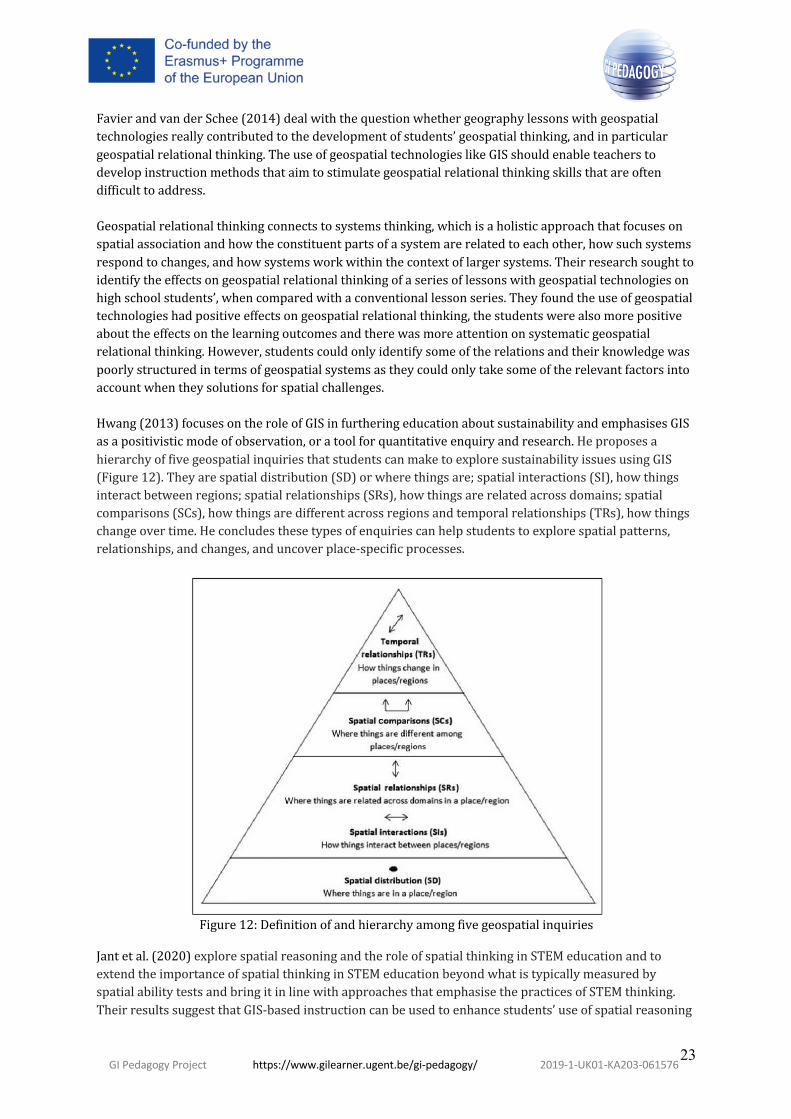
FavierandvanderSchee(2014)dealwiththequestionwhethergeographylessonswithgeospatialtechnologiesreallycontributedtothedevelopmentofstudents’geospatialthinking,andinparticulargeospatialrelationalthinking.TheuseofgeospatialtechnologieslikeGISshouldenableteacherstodevelopinstructionmethodsthataimtostimulategeospatialrelationalthinkingskillsthatareoftendifficulttoaddress.Geospatialrelationalthinkingconnectstosystemsthinking,whichisaholisticapproachthatfocusesonspatialassociationandhowtheconstituentpartsofasystemarerelatedtoeachother,howsuchsystemsrespondtochanges,andhowsystemsworkwithinthecontextoflargersystems.Theirresearchsoughttoidentifytheeffectsongeospatialrelationalthinkingofaseriesoflessonswithgeospatialtechnologiesonhighschoolstudents’,whencomparedwithaconventionallessonseries.Theyfoundtheuseofgeospatialtechnologieshadpositiveeffectsongeospatialrelationalthinking,thestudentswerealsomorepositiveabouttheeffectsonthelearningoutcomesandtherewasmoreattentiononsystematicgeospatialrelationalthinking.However,studentscouldonlyidentifysomeoftherelationsandtheirknowledgewaspoorlystructuredintermsofgeospatialsystemsastheycouldonlytakesomeoftherelevantfactorsintoaccountwhentheysolutionsforspatialchallenges.Hwang(2013)focusesontheroleofGISinfurtheringeducationaboutsustainabilityandemphasisesGISasapositivisticmodeofobservation,oratoolforquantitativeenquiryandresearch.HeproposesahierarchyoffivegeospatialinquiriesthatstudentscanmaketoexploresustainabilityissuesusingGIS(Figure12).Theyarespatialdistribution(SD)orwherethingsare;spatialinteractions(SI),howthingsinteractbetweenregions;spatialrelationships(SRs),howthingsarerelatedacrossdomains;spatialcomparisons(SCs),howthingsaredifferentacrossregionsandtemporalrelationships(TRs),howthingschangeovertime.Heconcludesthesetypesofenquiriescanhelpstudentstoexplorespatialpatterns,relationships,andchanges,anduncoverplace-specificprocesses.
Figure12:Definitionofandhierarchyamongfivegeospatialinquiries
Jantetal.(2020)explorespatialreasoningandtheroleofspatialthinkinginSTEMeducationandtoextendtheimportanceofspatialthinkinginSTEMeducationbeyondwhatistypicallymeasuredbyspatialabilitytestsandbringitinlinewithapproachesthatemphasisethepracticesofSTEMthinking.TheirresultssuggestthatGIS-basedinstructioncanbeusedtoenhancestudents’useofspatialreasoning

GI Pedagogy Project https://www.gilearner.ugent.be/gi-pedagogy/ 2019-1-UK01-KA203-061576
24
whensolvingSTEM-relevantproblems.TheyindicatethatGIStraininghelpsstudenttoconsider,understand,andimplementspatialsolutionsandthustheauthorsrecommendspatialthinkingcould,andshould,becentraltoscientificreasoning,justasmodellingandevidence-basedargumentationare.PerdueandLobben(2013)proposeaspatialthinkingframeworkandhypothesizedthatcertainspatialthinkingskillsarehigherorderthanothersandbuilduponprevious,lesscomplexskills(Figure13).So,intheexampleshown,regionalidentificationisconceptualizedasahighlevelskill,achievedthroughtheaccumulationofproximity,boundary,clustering,andclassificationskills.
Figure13:Aspatialthinkingframework(Perdueetal.,2013)
5.3 TPCKandG-TPCKTheTechnologicalPedagogicalContentKnowledge(TPCK)frameworkhasprovidedatheoreticallensforintegratingtechnologyinteachinginschool(Figure14).Itconceptualizesthreeknowledgeareasforteachers,thesubjectmatterordisciplinarycontent,usingtechnologiesanddigitalresourcesandlearningandteachingprocesses(pedagogy).Kerskietal..(2013)suggestprofessionaldevelopmentinteachereducationmustbeexpandedanditneedstoembracethetechnologicalpedagogicalcontentknowledgewhichcapturesthecomplexinterplayamongcontent,pedagogy,andtechnology.

GI Pedagogy Project https://www.gilearner.ugent.be/gi-pedagogy/ 2019-1-UK01-KA203-061576
25
Figure14:TheTechnologicalPedagogicalContentKnowledge(TPCK)framework(afterMishra,2019)
Walsh(2017)saysteachersoftenavoidengagingwithGISwithresearchsuggestingthatthelackofGIStrainingininitialteachereducationispartiallyresponsible.Shestates,“SuccessfuluseofGISineducationrequiresthatteachershaveastrongunderstandingofgeographicalcontentknowledge,geospatialsoftwareapplications,dataanalysistechniques,andpedagogicalstrategies(Coulter,2014);assuch,professionaldevelopmentinteachereducationshouldbeexpandedtoembracethetechnologicalpedagogicalcontentknowledge(TPCK)”(Walshe,2017;619)Hammondetal.(2018)exploredthedynamicrelationshipofTPCKandfoundthatdevelopingteachers’geospatialTPCKisparamountforsolidintegrationofthesetechnologiesintoteaching.Simplyengagingwithtechnologyiswillnotimprovestudentlearning,educatorsshouldconsiderwhichpedagogieswillbemosteffective(Hicksetal.2014).TodothistheTPCKapproachrecommendsthatteachersalsoneedtechnologicalandgeographicalcontentknowledge.IndevelopingTPCK,MishraandKoehler(2006)integrateeffectivetechnologyuseintothecurriculum,basedonthestrengthofteachers’pedagogicalandcontentknowledge(PCK).RoigandFlores(2014)pointoutthatwhiletheremaybehigh"contentknowledge"amongteachers,thesamedoesnothappenwith"technologicalknowledge".Newerteachersoftenratetheirtechnologicalknowledgeashigherthantheirsubject/pedagogicknowledge,perhapsdemonstratingalackofconfidence(Álvarez-OteroanddeLázaroyTorres,2018).GómezTrigueros(2018)explorestheuseoftheTPACKmodelforintroducingGIS.Hesuggeststhattheteacher’sownsubjectknowledgeandtheirpedagogicalknowledgeneedtobeconsideredsimultaneously.ThemodelproposesthatinorderforteacherstohavetrainingtoincorporateICTintheclassroom,theyneednotonlytopossess“thebasicknowledge”inanisolatedandindependentway,butalsotopossessthemininteractionwiththeapproach.Heproposesthatonlyinthiswaywillthetechnologybeincorporatedintothetrainingprocessinanappropriatemannerandachievethestudent'sintendedteachingandlearningobjectives.

GI Pedagogy Project https://www.gilearner.ugent.be/gi-pedagogy/ 2019-1-UK01-KA203-061576
26
Curtis(2019)usesMishraandKoehler’s(2006)Technological,Pedagogical,ContentKnowledge(TPCK)frameworktoexaminetheinfluenceofpedagogicalknowledgeonteachers’decisionmakingwhenteachinggeography.Sheexaminedteachingthatintegratesprofessionaltoolsintheschoolclassroomandsuggeststhisissupportedbywell-documentedlearningstandardsandstudies.Shedescribeshowinstructionthatreflectstheactionsofbusinessneedswillenablegeographyteacherstoprepareknowledgeable,criticallythinkingtwenty-first-centurystudentsthroughgenuine,geographicalcontextsthatfostercollaborationandtheapplicationofknowledgetorealisticscenarios(CharlesandKolvoord,2016).However,researchshowedthatgeographyeducatorshavetodiscovermethodsontheirownastheyarenottaughtpedagogicalstrategiesforteachingwithgeospatialtechnologies.Doeringetal.(2009)recommendteachershavetodevelopgeographicaltechnologicalpedagogicalcontentknowledge(G-TPCK).Thefocuschangesfromwhatteachersshouldknowtoeffectivelyintegratetechnologyintotheirclassroomstostudyinghowtheirgeographicalknowledgeshouldbeusedwithintheclassroomforthemosteffectiveresults.Theyproposeaproblem-basedGeoThentictrainingcoursewhereteachersdeveloptheirtechnologyknowledgeusinggeospatialtechnologies,theirpedagogicalknowledgebyinvestigatingoptimalpedagogyforgeographicproblemsolvingwithgeospatialtechnologies;andtheircontentknowledgebydevelopingthespecificgeographicalcontentareaneededtoeffectivelyteachtheproblem-solvingmodules.Rickles,EllulandHacklay(2017)identifiedthetheoreticalelementsofGISconceptsandconnectedthemtotheeducationalapproacheswithintheTPCKframework(Figure15).TheyindicatethatContextBasedLearningistherecommendedlearningapproachorpedagogicalknowledge.Theuseofcontextreferstoboththelocallearningenvironmentandthecontextoftheproblemdomainforthelearningactivity.IdentifyingtheplatformstouseprovidesthetechnologicalknowledgeandthecontentknowledgewouldbebasedonthecurriculumsubjectorinhighereducationtheGIS&TBodyofKnowledge(Prager,2012).ResearchbyCurtis(2019)revealedapossiblerelationshipbetweenpedagogicalknowledgeandthefrequencyofuseanddepthofintegrationofGItechnologyintogeographyteaching.Shestatedthatitwasimportanttodevelopteachers’G-TPCKforthemtoacceptthetechnologyandimplementitingeographyclassrooms.

GI Pedagogy Project https://www.gilearner.ugent.be/gi-pedagogy/ 2019-1-UK01-KA203-061576
27
Figure15:GISandtheTPCK)framework(Rickles,EllulandHacklay,2017)
Hong,andStonier(2015)suggestedenquiry-basedlessonsusingGIStechnologieswouldbeawaytointegratetechnologiesusingtheTPACKmodel.TheirresearchsuggestedfourdifferentusefulmethodstointroduceGIStostudentsforthefirsttime:
1. makingthefirstactivityrelatetothestudents(e.g.“makestudentsinterestedinGISfirst”and“getfamiliarwithGIS”,forinstancebyaskingstudentstomakeanindividualmaptolayouttheirlives,suchasthelocationsoftheirhomesandschools”),
2. exposingstudentstoGISasmallamountatatime,introduceitgraduallysothatstudentswouldnotfeelintimidatedoroverwhelmedwhentheystartusingGIS.
3. usingpeerleaders,creatinghelpandsupportamongthemselvesandmonitoringbyteachersand
4. providingtutorialvideos.
5.4 Thresholdconceptsandpowerfulknowledge
ThresholdconceptsoriginatedinMeyerandLand’s(2003)workassessingaspectsofstudentlearning.Theyaredescribedasconceptswhich,oncegrasped,leadtoatransformedviewofsubjectmatter(Figure16).Theprocessofgraspingthresholdconceptsimpliescrossingaconceptualgatewaywhichmayresultfromovercomingtroublesomeknowledge.
MeyerandLand(2006)describethecharacteristicsofthresholdconceptsastransformativechangingthewayyouseetheworld;troublesomewhereitmightseemcounterintuitive,irreversiblemeaningthatonceitislearntitisunlikelytobeforgotten;integratedasitrevealsconnectionsbetweenthedifferentpartsofthediscipline,boundedwherebytheconcepthasdefinedparametersinwhichitappliesanddiscursivesothatitleadstothedevelopmentofnewlanguage.Enser(2017)suggeststhatthresholdconceptsarean

GI Pedagogy Project https://www.gilearner.ugent.be/gi-pedagogy/ 2019-1-UK01-KA203-061576
28
importantelementincheckinglearning,andcouldbeafocustohelpunlockanewunderstandingoftheworld.
Figure16:Keycharacteristicsofthresholdconcepts(afterHamm,2016)
SrivastavaandTait(2010)presenttheimplementationofcurriculumdesignprinciplesforteaching,theysaytheadoptedpedagogyshouldutiliseexistingpedagogicalcontentknowledgeforthecoursematerial,identifythethresholdconceptsforthediscipline,involvestudentsinactiveandauthenticlearning,aswellasprovidingexperiencewithproblem-basedlearning,andtakesintoaccountthebackgroundsofthestudentsbyofferingflexiblelearningopportunities.Theirstudypresentsalearning-assessment-feedbackmodelinvolvingseveralcurriculumdesignprinciples.Theauthorsrecommendthatteachingshouldbebasedonrecenteducationresearchdevelopments.Thecurriculumdesignprinciplesstartfromdesigningtheaimsandoutcomesofthecoursefollowedbyasequentialarrangementoflearningactivities,leadinguptoappropriateassessment.Theresultwasthecreationofastudent-centredapproach,withopportunitiesforself-direction,guidedresponsibilityfortheirlearningandlearning/assessmentopportunitiesofferedinreal-worldcontexts(Figure17).
Figure17:AGISpedagogymodelinuse
Assessmentwasdesignedtodevelopfromsimpleknowledgeconceptsandmovetoanalysis,criticalthinkinganddeeperexamination,demonstratinghowGIScanbeappliedintheirdisciplineareas.Thus,

GI Pedagogy Project https://www.gilearner.ugent.be/gi-pedagogy/ 2019-1-UK01-KA203-061576
29
studentsmovefromunderstandingtheoreticalconceptstodirectlylinkingthetechnologyanddisciplineinanunderstandingofpracticalreal-worldapplicationofGIS.SrivastavaandTait(2010)offerasummaryofthethresholdbarrierstobecrossedforlearningtouseGIS(Figure18).TheysuggestmasteringthekeythresholdconceptswilltransformastudentfromageneralmapusertoaGISprofessional.Theidentificationofthesekeythresholdconceptsshouldresultintheidentificationofanyelementsoftroublesomeknowledge,whichcanformabarriertolearning.AsimilarsummarymightbeusefultoteachersforselectingtopicswhenlearningwithGIS.
Figure18:ThresholdconceptsforlearningGIS
Walshe(2018)warnsofthedangerofGISbeingreducedtojustamechanismforcompletingasetofskillsanddrawsonthetypologyofAlaricMaude(2018)todeveloppowerfulgeographicalknowledge,withreferencetotheGeoCapabilitiesprojectwithitsuseofcurriculumartefacts.GISallowsstudentstoengagewithopportunitiestocreate,testandevaluateknowledge.Maude’stypology(Table3)wasusedbyFargher(2018)toexemplifyhowacurriculumartefact,definedas“the‘key’toaseriesoflessonsonagiventopic”canbecreatedinArcGISOnlinetoconstructpowerfulgeographicalknowledge.Theexampledevelopedofthe2004IndianOceanEarthquakeandTsunamidemonstratestheneedforteacherstoleadwiththeirexpertsubjectknowledgetoensureengagementwithGISisunderpinnedbythesubject’skeyconceptsandsupportsthedevelopmentofstudents’geographicalthinking.Table3:Typologyofpowerfulgeographicalknowledge(afterMaude,2018)Typeofpowerfulgeographicknowledge
Description
Type1 Knowledgethatprovidesstudentswith‘newwaysofthinkingabouttheworld’
Type2 Knowledgethatprovidesstudentswithpowerfulwaysofanalysing,explainingandunderstanding
Type3 Knowledgethatgivesstudentssomepowerovertheirowngeographicalknowledge

GI Pedagogy Project https://www.gilearner.ugent.be/gi-pedagogy/ 2019-1-UK01-KA203-061576
30
Type4 Knowledgethatenablesyoungpeopletofollowandparticipateindebatesonsignificantlocal,nationalandglobalissues
Type5 Knowledgeoftheworld
5.5 Geomedia,spatialcitizenshipandparticipatoryGISAccordingtoGryletal.(2010)spatialcitizenshipisanamalgamofthreemaincontributingareasofresearch,citizenshipeducation,theappropriationofspaceandthelinksbetweenGIandsociety.Spatialcitizenshipwasthusdefinedastheabilitytocriticallyappropriatespacebydemocraticmeans.Spatialcitizenshipeducationisthereforeaboutlearninghowtonavigatetheworldwithrespecttothephysicalworld,themeaningsattachedtothephysicalobjectsandenvironmentandthepowerrelationsinvolvedintheproductionofmeaning.Threemainfieldsofcompetencewereidentified(Figure19).TheysuggestspecificstrategiesneedtobedevelopedforworkingwithGISthatgoesbeyondtechnicalcompetenceswidelyreproducedinmanycurricula.
Figure19:Competencesforspatialcitizenship
Geomediaismediathathasconsistsofspatiallylocalisedinformation,ithasbecomeanessentialpartofeverydaylife.Technologicaldevelopmentsenabledordinarycitizenstoparticipateandcollaborateusinganincreasingnumberofweb-basedapplicationsandmobiledevicesforgathering,processingandvisualisinggeoinformationandthensharinganddistributingtheirowninformation.FelgenhauerandQuade(2012)exploretheimplicationsofgeomediaforeducation,raisingissuesassociatedwiththetypesoflearningstylesneededtoaddressyoungpeopletoengageincitizenshipactivitiesandthereflectiveandreflexiveuseofGIandgeomedia.Gryl(2016)suggestsreflexivegeomediacompetenceandspatialcitizenshiparebasedonreflectionandreflexivity.Reflectionmeansbeingcriticaltowardsacertainmatter,reflexivityconnotesbeingcriticalregardingownthinkingandactingwiththismatter.Spatialcitizenshipandreflexivegeomediacompetenceaccountsforthesocialconstructionofspacesfromspatialthinkingapproachesfromgeomedia(GrylandJekel,2012).RoosaareandLiiber(2013)presentthesituationinEstoniawheregeo-mediaandGIShasbeenintegratedintoschooleducation,wherealistofcompulsoryICT-basedpracticalworkshavebeenaddedtothegeographycurriculum.Gryl(2016)aimedtoidentifyteachers’differentbasicabilitiesandtheirwillingnesstofurtherreflexivityandgeomediaapproachesatschoolandtoidentifyideastofurtherthedevelopmentofteachers’abilitiesandwillingness.Interviewsofteacherswereundertakentoconstructatypologyofteachers’abilityandwillingnesstofurtherreflexivegeomediacompetencesandspatialcitizenshipcompetencesamongtheirstudents.Sinhaetal.(2016)exploretheuseofParticipatoryGIS(PGIS)asapowerfulplatformforgeographiceducation.PGISresultedfromcommunityengagementresponsestotechnologicaldevelopmentsinGISandempowerment.PGISproducesmediausefulforcitizenadvocacyanddecisionmaking.Butthe

GI Pedagogy Project https://www.gilearner.ugent.be/gi-pedagogy/ 2019-1-UK01-KA203-061576
31
pedagogicalbenefitsofPGISprojectshavereceivedlimiteddirectattentionintheliterature,understandablesincePGISprojectsaredesignedtobeledbycommunitiesandthefocusshouldremainoncommunitydevelopmentandempowerment,notonhowstudentsandresearcherscanbenefitfromtheprocess.WhilePGISisnottheonlyapproachforteachingstudentsgeographyinthefield,itoffersoneofthemostflexibleandscalableoptionsofenablingstudentstoworkwithcommunities.PGISprojectsarenaturallysuitedforcomplementingclassroomtrainingbecauseparticipatingstudentsmustworkbeyondtheclassroomandinahostcommunity,theyhavetolearncollaborativeandcommunitydevelopmentskills,reflectontheirownsituationandcircumstanceswhilestrivingtosafeguardandpromotecommunityinterests;demonstratetheapplicationofhuman,physical,andgeospatialgeographicknowledgeinthefieldandfostercriticalreflexivityinstudents.PGISapproachescanhelpmeetdiverselearningobjectivesrelatedtolocalknowledgeandplace-basedthinking,understandingtherelationshipsbetweenpeopleandlandscapesthroughcommunityengagement,gettingpracticaltraininginfieldmethodsofcollecting,managing,processing,andvisualizinggeographicinformationandgainingexperientialandpracticalintroductiontoqualitative-quantitativemethodologies.Gordonetal.(2016)examineinteractiveparticipatorymappingforteachingandpractisingcriticalspatialthinking.Theyproposethatcriticalspatialthinkingisfoundationaltocivicengagementandthatdigitalgeographicpedagogiesareanimportantarenainwhichyoungpeoplecanbuildtheseaptitudes.Theyshowhowinteractivedigitalmappingpedagogiesofferstudentsanopportunitytodevelopawarenessofwhathappensintheirurbangeographiesandguideandinformcivicengagement.Theyillustratehowcriticalciviclearninghappensasaresultofastudent-guidedexploratoryprocess,collaborativework,andsharingwithandlearningfromtheirpeers.
5.6 Thestorytellingtechniqueandwebmaps
Kerski(2015)includesstorytellingasoneofthefiveconvergingglobaltrendsthatareexertinggreatimpactongeography.Theevolutionofgeographictools,data,andmultimediaonthewebexpandtheabilityandaudienceforstorytellingthroughmaps.Hedescribestheimportanceofeducatingageoliteratepopulationthatcanassessandusegeographicinformationtomakewisedecisions.MotalaandMusungo(2013)examinetheeffectsonstudentlearningbyintroducingstorytellinginGISteachingandlearningactivities.IncorporatingstorytellingintoGISanalysisandmappinghelpedstudentstovisualizecomplexconcepts.Theysuggestthatmultimediastorytellingwasapowerfullearningmethodasthestudentsweregivenopportunitiestotelltheirownstoriesandempathisewiththegeography.Theirownpersonalnarrativeshelpedthestudentstointernalisethelearning.Sherrington(2018)summarisesDanielWillingham’s(2009)explanationoftheimportanceofnarrativeconnectionsinmemory-making.Hesaysthatstorieshavefourfeatures,causality,conflict,complicationsandcharacter.ItislikelythatinnovativepedagogiesshouldconsiderhowGISresourcescanusetheprinciplesofstoriestohelpstudentsrecogniseandunderstandgeographicalpatterns,processesandconcepts(e.g.addinglayersincoherentstages;storymaps)andhowthestepsoflearningaGIStechniquemightbetaughtmoreeffectivelybyfollowingthestorytellingprinciples.Storymapsusuallyintegratetext,multimediaandinteractivefunctionstoinform,educate,entertainandinspirepeople.MartaandOsso(2015)describetheirprojectinitiative“StoryMapsatschool:teachingandlearningstorieswithmaps”.Workingwithgroupsofteachersandtheirclassestheyfoundthatstorytellingwithmapsmotivatedstudentsandestablishedapositiveattitudetowardslearning.The

GI Pedagogy Project https://www.gilearner.ugent.be/gi-pedagogy/ 2019-1-UK01-KA203-061576
32
studentswereactivelyinvolvedinthestorymappingprocess,beingcreativeintellingtheirownstoriesandencouragingthemtoaskquestions.Sui(2015)reflectsontheusesofmapstoriesorlocation-basedstorytelling.Hesaysthattoday’smapsarethusnotsimplyusedasillustrations,instead,theyareincreasinglyusedasamediumtotellstoriesandhelplearnersacquiredeepermeaningthroughtheireducationalactivitieswithGISandfocusonPink’s(2006)frameworkofthesixsensesofthenewmind,design,story,symphony,empathy,playandmeaning.

GI Pedagogy Project https://www.gilearner.ugent.be/gi-pedagogy/ 2019-1-UK01-KA203-061576
33
6. PedagogiesLittleresearchattentionhadbeenpaidtopedagogicalissuesinusingGIS(Donert,2007;Bednarz,2001),yetaccordingtoMathewsandWikle(2017).surveysofemployerssuggestimprovedpedagogicalapproachesinteachingGIS&Tareneededastheworkforceisoftenpoorlypreparedtotakeonreal-worldproblems.RoosaareandLiiber(2013)confirmthatmaininfluenceonteachingatschoolsistheteaching-learningprocessintheclassroom,whichisdependentonteachers'professionalismandtheirenthusiasmtoimplementnewtechnologiesandteachingmethods.Stringeretal.(2019)statethattoimprovelearning,thetechnologymustbeusedinawaythatisinformedbyeffectivepedagogy.Sanchez(2009)assessedthewaygeotechnologiesbeintegratedintothegeographycurriculumforsecondaryeducation,andwhateffectstheyhaveintermsofpedagogicalsettingandeducationalgoals.Evidencehegatheredsuggestedthatgeotechnologieswerebeingusedindifferentpedagogicalcontexts:withthewholeclassthroughtheuseofadataprojector,withsmallgroupsofstudentsorindividualusewhereastudentisaloneinfrontofacomputer.MatthewsandWikle(2019)wereconcernedwiththewayGIScoursescanbedesignedtoaddresslearningobjectivesthatpromotecreativethinking,advanceproblem-solvingskills,andfostercollaboration.Theirgoalistoassessthepedagogicalapproachesusedtoteachcourses,aswellasidentifythechallengesassociatedwithsuchteaching,basedonanInternet-basedsurveyof318collegeanduniversityfaculty.Theyfoundactivelearningmethodswerenotwellintegratedwithinclassesandnotedthatstudentsneededtoreceiveasolidconceptualframeworkandteachingstrategieswouldbenefitfrommoreactivelearningapproachesandotherteachinginnovations.Theysuggestedcoursesshouldbedesignedtoaddresslearningobjectivesthatpromotedcreativethinking,advancedproblem-solvingskillsandthatfosteredcollaboration.Muijs(2020)highlightstheincreasedimportanceofthe‘Scienceoflearning’beingusedtoinformclassroompractice.Thereisagrowingawarenessofthepotentialhelpthatself-regulationandmetacognitivestrategiescanhaveonlearning.Muijssupportstheviewthatself-regulationrelatestothelearner’sawarenessoftheirownstrengthsandweaknesses,andislinkedtotheirmotivationtodeveloptheirownlearningstrategies.Thisheseesasbeinglinkedtothreebroaderfunctions:cognition,whichisinformationprocessingandpractice;metacognition,whicharethestrategiesthatcontrolcognitionandmotivation,whichislinkedtointerestandself-belief.Coeetal.(2020)reportontheGreatTeachingToolkit,findingthatakeyfeatureofgreatteachingisthatteachersunderstandthecontenttheyareteachingandhowitislearnt.Theysuggestthatteacherswhowanttoincreasetheireffectivenessshouldfocusonfourpriorityareas,i)understandingthecontenttheyareteachingandhowitislearnt,ii)creatingasupportiveenvironmentforlearning,iii)managingtheclassroomtomaximisetheopportunitytolearnandiv)presentingcontent,activitiesandinteractionsthatactivatetheirpupils’thinking.Allier-Gagneuretal.(2020)suggesttheseprinciplesgiveanindicationofthetypeofpracticesthatcouldbesharedwithteachersduringteacherdevelopmentsessions.
6.1 CriticalspatialthinkingAccordingtoGoodchildandJanelle(2010)educationapproachesmustrecognizetheneedtoimpartproficiencyinthecriticalandefficientapplicationofthesefundamentalspatialconcepts,ifstudentsaretomakeuseofexpandingaccesstothegrowingamountsofspatialinformationanddataprocessingtechnologies.Thetermcriticalimpliesbeingreflectiveoranalyticalofspatialperspectivesandinusingactivequestioningandexaminationofthedata,thetechniquesandthecontext.Thechallengefor

GI Pedagogy Project https://www.gilearner.ugent.be/gi-pedagogy/ 2019-1-UK01-KA203-061576
34
educationishowtodeveloptechniquesofcriticalspatialthinking,sothatstudentswillbebetterpreparedtousetheevolvingtechnologies,andbetterequippedtoexploitthegrowingfloodofspatiallyreferenceddata.Theauthorssuggeststudentsshouldbetrainedthattothestandardsofacriticalspatialthinker,including,thepotentialtocontributecriticalspatialunderstandingtoinformationattheinterfacebetweendisciplines;toworkinateam;toexplainthespace–timecontexttonon-experts;theabilitytodevelopnewandhighlyoriginalspatiallyinformedideas;toenablesustainedandsuccessfuldialogwithinaninternationalcommunityofspatiallyawarescientists;todisseminatespatialunderstandingthroughteachingandcurriculumdevelopmentatK-12andundergraduatelevels;andtotransferspatialtechnologiesandspatialconceptsacrossdifferentknowledgedomainsandproblemsets.Willingham(2007)askswhethercriticalthinkingcanactuallybetaughtsuggestingthatthereisnosetofcriticalthinkingskillsthatcanbeacquiredanddeployedregardlessofcontext.Hesuggeststherearemetacognitivestrategiesthat,oncelearned,makecriticalthinkingmorelikelyandthattheabilitytothinkcriticallydependsondomainknowledgeandpractice.Thereforeproposingthatteachingstudentstothinkcriticallyprobablyliesinlargepartinenablingthemtodeploytherighttypeofthinkingattherighttime.Kaminske(2020)confirmsitiscontextdependentandpeoplecanthereforebegoodatcriticalthinkinginonedomain,butbadinothers.Criticalspatialthinkingtypicallyreferstoadeeperunderstandingofrelationshipssuchasspatialdependenceorspatialheterogeneity(NationalResearchCouncil2006);ortoreflexivityintheuseofspatialdataandtechnologies(e.g.assessingthereliabilityofdigitalspatialdataandgeospatialrepresentationsormakingandevaluatingargumentswithspatialdataandmapsKimandBednarz(2013)suggestcriticalspatialthinkingisakeyaptitudeforcivicengagementviadigitalgeotechnologies.Theydevelopedaninterview-basedcriticalspatialthinkingoraltest(ACriticalSpatialThinkingOralTest-CSTOT)totestproblemsolvingontheirownandusedthetesttoinvestigatetheeffectsofGeographicInformationSystem(GIS)learningonthreecomponentsofcriticalspatialthinking:evaluatingdatareliability,exercisingspatialreasoning,andassessingproblem-solvingvalidity(Golledgeetal.,2008).TheirstudydemonstratedthatdoingaGIScoursewasbeneficialinenhancingstudents’criticalspatialthinking,identifiedastheabilitytoassessdatareliability,usesoundspatialreasoning,andevaluateproblem-solvingvalidity.TheysaythatthiscouldbeexplainedbythenatureoflearningtouseGIS,asspatialreasoningisrequiredsostudentsareabletoapplyideasinpracticeandsolveproblems.MilsonandCurtis(2009)foundthatlearningwithGISwasaneffectivewaytoenhancestudents’criticalspatialthinking.Theseresearchersaskedstudentstoselectasuitablelocationforanewbusiness.Studentshadtodeterminecriteriaonwhichtobasetheirdecision,finddatatosupportthecriteria,andfinallydefendtheirthinkingprocesses,allofwhichsupportedthedevelopmentofcriticalspatialthinking.Liuetal.(2010)reportedthatproblem-basedlearningwithGISdevelopedstudents’higherorderthinking,suchasanalyticalandevaluationskills.Mostconceptsofcriticalspatialthinkingareeitherstronglyorientedtowardsgeospatialrepresentationorconcernhowdigitalspatialdataaremadeanddisseminated.Byfocusingongeospatialdataandrepresentation,thesenotionsofcriticalspatialthinkingdonotrelatetowhatyoungpeopleneedtoknoworunderstandabouttheworldaroundthemandtheircivicengagement.However,itisnecessarytolearnfromfirsthandreliablesourcesandtorepresentdatatoenableaclearandrealinterpretationofinequalities.Students’educationmustincludeunderstandinghowinequalitiesinsocietyaregeneratedandhowtheyandothersocialactorsmightintervenetochallengethem.

GI Pedagogy Project https://www.gilearner.ugent.be/gi-pedagogy/ 2019-1-UK01-KA203-061576
35
6.2 Activepedagogiesandenquiry-basedlearningTheuseofgeotechnologiesinschoolsfacilitatestheimplementationofenquiry-based-learning(Sanchez,2008a)andopen-endedprojectsforteaching(Kerski,2008).ThisisprobablypartlyduetothefactthatGISallowsclassroomproceduresthatareclosetoprofessionalprocedures,includingmodellingorsimulation(Sanchez,2008b).Pedagogicdevelopmentshaveechoedthe“hands-on”emphasisinmuchGeographyeducation,characterisedbyactivelearninginthefieldandlaboratory,andtheadoptionofKolb’sexperientiallearningtheory(HealeyandJenkins,2000).MathewsandWikle(2019)foundthatactivelearningpedagogiesarebecomingmorefirmlyestablished,supplementingorreplacingtraditionalteachingapproaches.Thestrategiesthatencourageactivelearningarebasedoninteractivityinlearning-by-doing(Scheyvensetal.,2008).Inadditiontofacilitatingstudentengagement,activelearningencourageselementsofcriticalthinkingthroughstudentreflection(Scheyvensetal.,2008)andstudent-drivenproblem-solvingthatmayinvolvereal-worlddata(Connersetal.,1998).Chen(1997)appliedproblem-solvingtoactiveGISlearningactivities(Figure20).Thesestudent-centeredapproachesarealsowelldocumentedoutsidetheuseofGIS(Park,2018).
Figure20:ProblemsolvingandactivelearningwithGIS(afterChen,1997)
Intermsofscope,activelearningincludesarangeofstrategieswithvaryinglevelsofstudentengagement,suchas“flipped”classroomswheremeetingtimesarereorganizedtoreplacetraditionallectureswithstudent-centredactivities.Studentsinflippedclassroomsreviewothermaterialsinadvanceofclassmeetings,enablingclasstimetofocusonproductiveopen-endeddiscussionorcollaborativelearningactivities(Reidsemaetal.,2017).Similaractivelearningmethodsthatwerenotedincluded“think–pair–share”,whichcanbeintroducedusingareadingassignmentorpresentationfollowedbyaseriesofquestionsposedbytheteacher.Studentssubsequentlywritereflectivestatementsandthenworkinpairsorsmallgroupstodiscussandcompleteassignments.AlthoughnotfocusedonGIS,severalotherstudiesdemonstratedtheeffectivenessofactivelearninginincreasingstudentengagementandperformance(LeeandShahrill,2018).Somedisadvantagesofactivelearningstrategieshavealsobeen

GI Pedagogy Project https://www.gilearner.ugent.be/gi-pedagogy/ 2019-1-UK01-KA203-061576
36
noted,suchastheaddedtimeneededforpreparingmaterialsandchallengespresentedbylargeclasssizes.Despitethebenefitsassociatedwithactivepedagogicalapproaches,arecentsurveyofscience,technology,engineering,andmathematics(STEM)fieldsdemonstratedthatthemajorityofcollegeteacherscontinuetorelyonpassive,lecture-basedinstructionalmethods(Stainsetal.,2018).AsnotedbyŞeremetandChalkley(2015),GIScoursesarenoexception.Itiscommonlyacceptedthatwhentheoryiscombinedwithpractice,theeducationaloutputbecomesbeneficialforthestudents’learning.Traditionalteachingmethodsaresupplementedbyotherapproaches,suchasenquiry-basedlearning,whichinvolvecomplexproblemsandscenarioswithfieldworkandcasestudies.Therefore,whenusedtoitsfullpotential,theuseofGISinschoolscanprovidealearningenvironmentwithprovenpotentialforenquiry-basedactivities,withstudentslearningaboutgeographicalproblems,issuesandeventsofreal-worldrelevance(FargherandRayner,2012).Enquiry-basedlearninginvolvesexploring,analysingandactingupongeographicalknowledge.TeachersneedtobemorecriticallyawareofthekindsofgeographicalthinkingthatcanandcannotbeenhancedthroughGIS.Enquirylearningincludessuchprocessskillsasobserving,classifying,measuring,predicting,inferring,summarising,communicating,collectingdata,analysingdata,drawingconclusions,buildingmodels,interpretingevidence,andexperimenting.Throughenquirylearning,problemsolvingstrategiesareemployedtoidentifyassumptionsandconsideralternativeexplanations.GISenquiryisusuallybasedonfivesteps(Table4),withstudentsareencouragedexploringspatialrelationsandpatternsamongdataanddrawingsensibleexplanationstowardstheobservations.Table4:StepstoenquirywithGIS(afterFargher,2018)Step WhattoDo TypeofKnowledgeConstructionAskageographicalquestion
Askquestionsabouttheworldaroundyou
Enquiry
Acquiregeographicaldata
Identifydataandinformationthatyouneedtoansweryourquestions
Inventory
Exploregeographicaldata
Turnthedataintomaps,tables,graphsandlookforpatternsandrelationships
Spatialprocessingandanalysis
Analysegeographicalinformation
Testahypothesis,carryoutmap,statistical,writtenanalysisusingevidence
SpatialAnalysis,Modelling,
Actwithgeographicalknowledge
Takeoutcomesandevidenceandundertakeactionstofurtherthem
DecisionMaking,Dissemination
Thesestepsareintendedtoteachdisciplinarycontentthroughthedevelopmentofhigher-order,enquiry-processskills(i.e.,formulatingresearchquestions,designingorimplementingsystematicdatacollection,analysingandsynthesisingdata,andsoon).Suchenquiry-basedactivitiesarecriticaltothedevelopmentofproblem-solvingskills,which,astheworldhasseenmustbeemphasisedineducationsothattheyarepreparedtoeffectivelyandefficientlysolverealworldchallenges.Bonnstetter(1998)describedenquiryasanevolutionarylearningprocessinwhichtherolesoftheteacherandstudentchangeasshowninTable5.Enquirylearningcanbedefinedasthestudent-basedexplorationofanauthenticproblemusingtheprocessesandtoolsofthedisciplineorcontent.Processskillsmayincludeobserving,classifying,measuring,predicting,inferring,summarizing,communicating,collectingdata,analysingdata,drawingconclusions,buildingmodels,interpretingevidence,andexperimenting.Thisapproachhasthepotentialtochangegeographyeducationforthebetterbecauseitcanbeusedtoprovidemeansofaccessingandanalysinggeographicaldatathatcansupportdeepergeographicalunderstanding.

GI Pedagogy Project https://www.gilearner.ugent.be/gi-pedagogy/ 2019-1-UK01-KA203-061576
37
Table5:Enquiryevolution(afterBonnstetter,1998)
Walshe(2017),reportingontraineeteachersandtheiruseofGIS,confirmedthatwithregularusetheydevelopedamorenuancedunderstandingofthenatureofGIS,fromseeingitasamethodofdatadisplaytorecognisingitsvalueforsupportingstudent-centred,enquiry-basedlearningandthedevelopmentofgeospatialthinking.TheirrepeatedexposuretoGISwithincreasingcomplexitysupportedthedevelopmentoftheirpracticeasitgavethemtheopportunitytoengagewithitattheirownpace,allowingthemto‘tryout’ideasinschoolandthensharetheirideaswiththeirpeersandintegratingtheuseofGISintotheirteaching.Enquirybasedlearningcanalsointegratemanyothertechniques,suchaslearninginequalpairsandcollaborativelearning(Figure21).
Figure 21: Steps in GIS enquiry (Source: De Lázaro, De Miguel and Buzo, 2016)
Arecentsurveyofthegeo-educationcommunityfoundthatactivelearningpedagogieshavebecomemorefirmlyestablished,supplementingorreplacingtraditionalteachingapproaches(MathewsandWikle2019).Thisisconsistentwiththeideathatthelearningprocessbeingexperiencedbystudentsisa

GI Pedagogy Project https://www.gilearner.ugent.be/gi-pedagogy/ 2019-1-UK01-KA203-061576
38
dynamicandactiveone,andapproachesbyinstructorsthatareineffectivecanbecounter-productive(DiBiase2018).Project-basedandproblem-basedlearningwerethemostpopularapproachesastheymostcloselymimicauthentic,real-worldexperiences(Bowlicketal.2016,HowarthandSinton,2011).
6.3 Problem-basedlearningandcontext-basedlearningGISeducatorshavelargelyadoptedinnovativeapproachessuchasproblem-basedlearning(Drennon,2005)andparticipatoryaction(Elwood,2009)incourses.Problembasedlearning(PBL)hasbecomeregardedasaneffectiveandpopularformatforlearningwithGIS.WorkingthroughproblemswithGISoperationsmimicstheapplicationofGISto“real-world”issues.InPBL,thelearningoutcomesareoftenunstructured,withthestudentsincontroloftheprocessthroughwhichsolutionswillbeidentifiedandreached.Inthisform,studentsarepresentedwithasituationandthenproceedtoorganizethestrategiesandmethodsforgatheringinformationandreachinganoutcome.Anauthenticproblemisattheheartoftheexperience,reflectingthereal-worlduncertainties,messiness,tensions,andpolitics.Inclassroomsettings,accordingtoHowarthandSinton(2011)PBLismorestructuredandcantakemultipleformswithvaryingdegreesofproblemcomplexityandteacherinvolvement.However,theamountoftimemaydictatethattheproblemsthemselvesaresimplified,withprepareddataandexpectedoutcomes.Theburdenofdesignandpreparationisontheteacherandactivitiesarehighlycontrolled.Sanchez(2009)suggestedthepedagogicalfeaturesofaproblem-based-learningapproachappearedtohaveapositiveimpactonthestudentsuseofgeotechnologiesinschools.Hubeauetal.(2011)introducedaSupervisedSelf-Study(SSS)teachingapproachinthepracticalpartsoftheGISandTechnologycoursesatKULeuveninBelgium.ThestudentssolveandreportbackonasetofexercisesusingwithFreeandOpenSourceSoftwaresystems(FOSS),whilehavingthepossibilitytoreceivesupervisionandfeedback.Studentsuse“conceptualexercises”tosolveproblemsindependentlyofwhichGISsoftwaretoolsarebeingused.Themainadvantagesofthisteachingapproachisinthetime-efficiencyandthestimulusforstudentstodealactivelywiththelearningmaterials.Theirresearchrevealedthatifinsufficienthumansupport,adviceandfeedbackavailablethenstudentscouldloseinterestandmotivation.Rickles.EllulandHacklay(2017),focusonhowtoimprovelearningGISinaninterdisciplinaryresearchcontext.Context-basedlearning(CBL)isdescribedasapedagogicalmethodologythat,inallitsdisparateforms,centresonthebeliefthatboththesocialcontextofthelearningenvironmentandthereal,concretecontextofknowingarepivotalintheacquisitionandprocessingofknowledge.Thisconcernsthereforethelearningenvironmentandthereal,concretelearningactivitycontextofknowledgeacquisition.Theauthenticity(i.e.relevancetoreal-worldproblems)iskeytoengagingthelearnersandallowingthemtoreflectonthelearningprocesswhenlearningwithGIS.
6.4 Project-basedapproachesManyapproachestousingGISinschooleducationhavebeenrelatedtoproject-basedpedagogies(MilsonandEarle,2007;Kerski,2008;Favier,etal.,2009;Demircietal.,2011).DeLázaroyTorresetal.(2016)raisetheneedtointegrateGeographylearningtechnologiesinschools.Forthis,itisnecessarytotrainfutureteachersbyprovidingrelevanteducationalexperiences.Theyproposeanactivemethodologyandgrouptechniques,manyofwhichareusedintheprofessionalworld,suchasproblem-basedlearningandproject-basedlearning.Demircietal(2010)introduceanationallyfundedprojectdesignedtouseGIStodevelopsocialsensitivityamongstudentsthroughtheimplementationofGIS-basedprojectsingeographylessonsat

GI Pedagogy Project https://www.gilearner.ugent.be/gi-pedagogy/ 2019-1-UK01-KA203-061576
39
secondaryschool.Theprojectinvolvesstudentsindifferentactivitiesrangingfromconductingasurveyofthepublic,identifyingthemainsocial,economicandenvironmentalproblemsinsociety,developingprojectstosolvesomeofthecurrentproblemsincooperationwithgovernmentalagencies,usingGIStocollect,store,manipulate,andanalysedata,andinformingpublicandrelevantinstitutionsabouttheoutcomeoftheirprojects.Thedevelopproject-basedlearning,withtheuseofinformationandcommunicationtechnologies,anddevelopmentofstudents’socialsensitivityandmayalsobelabelledasservicelearning.EstevesandRocha(2015)analysehowPortugueseGeographyEducationhasaddressedteachingwithGIS.TheypresentsomeprojectsthathavebeendevelopedinordertoenhancetheuseofGISintheclassroom.Theysuggesttheteachershouldcreateproceduresthatwouldleadthestudentstorealizethattherecanbemultiplehypothesesinrealproblemsolving.Therefore,theidentificationprocessesandlearningofspatial-temporaltransformationwouldbefacilitated,whichisfundamentaltotheunderstandingofgeographicalphenomena.EstevesandRocha(2015)describeasecondaryschoolprojectcalled“WePropose!”,inwhichschoolsidentifylocalproblems,createsolutionsandpresenttheseattheUniversityofLisbonandlatertolocalauthorities.IncurriculumtermstheK11studentsinvolvedarerequiredtodevelopacasestudyduringtheschoolyear.Thestudentsresearchlocalproblems(withintheGeographysyllabus),contactlocalauthoritiestolearnaboutmoreabouttheproblemsandwhatishappeningintermsofplanningatalocalscale.TheygetGIStrainingsogeotechnologycanbeusedtopresentproposedsolutionsandpresentresearch-basedproposalstosolvetheidentifiedproblems.Studentsthusbecomeengagedinactivecitizenship:animportantskillacquiredinGeographyEducation.TheydevelopanduseGISskills,workonreallifeproblemsandpresenttheresearchtheycarriedouttolocalauthorities.Furthermore,themunicipalauthoritieswillimplementthestudents’researchprojectinthecity.Huei-Tseetal.(2016)analysetheuseofawebmapmindtoolcreatedfortourplanninginordertoassistlearners’project-basedlearning.Students’assessmentdemonstratedapositiveattitudetowardthecollaborativeproblem-solvinglearningandimprovementontheircognitiveskills.TheyconfirmedtheworkofJoandBednarz(2009)whichsuggestedthecognitiveprocessesofspatialthinkingconsistedofthreelevels,firstlydescribing,specifyingandobservingapieceofinformation(thinking).Secondly,processingofinformationwhereanalysis,classificationandinterpretationtakesplacetoacquireunderstanding.Thethirdleveliswhereinformationisevaluatedandintegratedtocreatenewknowledge.
6.5 LearningProgressions,TrajectoriesandlearninglinesLearningProgressions(LP)providesanapproachtostudyinghowstudentsadvancetheirknowledgeaboutasubjectastheirintellectualideasandabilitytocommunicategrow.Itisamethodusedbyeducationresearcherstobetterunderstandanddocumentthecapabilitiesofstudentsastheymovealongapathwaytogreaterunderstanding.Todevelopalearningprogression,theresearcherimmersesherselfintryingtounderstandthemultiplepathwaysthatstudentstaketoreachdifferentwaypointsofknowledgeaboutasubject(Huynhetal.,2015).Anunderstandingoflearningprogressionsmayhelpunderstandhowlearners’geospatialthinkingevolvesovertime.Thedevelopmentofalearningprogressionforgeospatialthinkingwouldincludeanorderingofgeospatialconceptsthatbuildstowardmoresophisticatedgeospatialunderstandingsandreasoningskills,whileprovidinglearningstrategiesandlearningexperiencestosupportstudentdevelopmentalongtheprogression.Assessmentmeasurestodefinestudents’progressonthelearningprogressionwillalsoneedtobeincluded.

GI Pedagogy Project https://www.gilearner.ugent.be/gi-pedagogy/ 2019-1-UK01-KA203-061576
40
LearningTrajectories(LT)aredefinedasempiricallysupportedhypothesesaboutthelevelsorwaypointsofthinking,knowledge,andskillinusingknowledge,thatstudentsarelikelytogothroughastheylearnandreachorexceedthecommongoalssetfortheirlearning(Solemetal.,2014).TheLPsandLTsshiftthefocusfromtheendpointtounderstandinghowideasbuildupononeanotherasstudentsdevelopdesiredknowledge,skills,andpracticesinadiscipline.Itdoesnotimplythatthereisasinglepaththroughtheprogression,multiplepathsarelikely.ALearningProgressionisaroadmaptocharthowdifferentstudentsproceedtothenextormoresophisticatedlevelofunderstanding(Larsenetal.,2018).LearningProgressionshaveanupperandloweranchorandlevelsofunderstanding(Figure22).Theloweranchorrepresentstheemergingknowledgestudentshaveasnovicelearnersofaconstructorpracticeandtheupperanchorisadepictionofwhatlearnersshouldknowandbeabletodoafterlearninghasoccurred.
Figure22:Learningprogressioncomponents(afterLarsenetal.,2018)
Huynhetal.(2015)suggestaLearningProgressiontypicallycomesinthreestages.Thefirststageinvolvesthecreationofahypotheticalprogressionbasedoncoreideasandskillsets.Inthesecondstage,thelowerandupperanchorsarerefinedbyresearchersbasedontheirexperiencewithstudentsanddevelopresourcesandpotentialassessmentmaterialsrelatedtoaparticularconcept.Finally,inthethirdstage,experimentsareconductedtotracestudentlearningovertime.Studentunderstandingisassessedthroughasetofprogressvariables(Gunckeletal.2012).Throughoutadetailedanditerativeprocess,researchersworktoeditandrevisetheLearningProgressionbasedontheirinteractionswithstudents(Stevensetal.2015).TheGeoProgressionsproject(Solem,,HuynhandBoehm,2015)wasaninitiallookatthepotentialvalueofapplyinglearningprogressionstomaps,geospatialtechnology,andspatialthinking,suggeststhatthislineofscholarlyresearchhassignificantpotentialtotransformaspectsofgeographyeducation(Huynhetal.,2015).DeMiguelGonzálezandDeLázaroTorres(2020)presenttheDigitalAtlasforSchools(ADE)anddiscussdifferentlearningmethods,progressionmodelsandtools(Table6).EmpiricalresearchonlearningresultsandbenefitsfromlearningwithADEaredescribed.TheyshowhowADEisapowerfultooltohelplearngeographyasitfostersmoremeaningfullearningthanconventionalinstructionalresources.Ithelpsinthegoaltobalancespatialthinking,geographicalknowledgeandspatialcitizenship.SchoolandhighereducationparticipantsexperiencedeffectivelearningimplementingtheDigitalAtlas,althoughthiswasmoremarkedinthesecondaryschoolgeographystudents.

GI Pedagogy Project https://www.gilearner.ugent.be/gi-pedagogy/ 2019-1-UK01-KA203-061576
41
Table6:LearningprogressionforspatialthinkingwiththeDigitalAtlasLevel0 NoevidenceofunderstandingLevel1 Studentscanunderstandprimitivegeospatialconceptssuchasidentity,locationLevel2 StudentscanidentifyspatialdistributionasasimpleconceptLevel3 Studentscanestablishgeospatialrelationsandidentifyclustersinthemap,adifficult
conceptLevel4 StudentscanidentifycorridorsandbuffersinthemapascomplicatedgeospatialconceptsLevel5 Studentsacquireextendedabstractthinking,astheycangeneralisecomplexspatial
structuressuchashierarchyorcentralplaceZwartjes(2018)presentstheGILearnerprojectandtheconceptoflearninglines.Alearninglineisaneducationaltermfortheconstructionofknowledgeandskillsthroughoutthewholecurriculum,reflectingagrowinglevelofcomplexity,rangingfromeasy(morebasicskillsandknowledge)todifficult(Lindner-Fally&Zwartjes,2012).GI-Learneraimedtohelpteachers,andinthelonger-termgovernments,implementlearninglinesforgeospatialthinkinginsecondaryschools.Inordertodothis,theprojectdefinedasetof10geospatialthinkingcompetencies,createdlearninglinesandtranslatedthemintolearningobjectivesandteachingandlearningmaterialsforthewholecurriculum(K7toK12).Eachblockoflearningbuildsontheprevious(Figure23).
Figure23:Alearninglineshowinglearningprogression
A‘learningline’asanoverallframeworkforeducationandtraining,withadistinctsequenceofstepsfrombeginnerstoexperts,itisanalytical;i.e.itdistinguishesindetailtheskills,knowledgeandattitudesonseverallevelsthatmaybeexpected.Itiscompetence-based,asitdistinguishesasetofcompetencesthattogetherbuildtheoverallcompetenceinthefield(Zwartjes,2019).DeMiguel(2016)givesanoverviewonlearninglinesandtheintegrationwiththegeographicalinquiryprocess(Table7).Table7.Learninglinesandgeographicalinquiryprocess Zwartjes Roberts Kerski Arayo,SoutoandHerreraLevel1 Perceiving Creatinganeedto
knowAskingGeographicalquestions
Perceivinggeographicalenvironment

GI Pedagogy Project https://www.gilearner.ugent.be/gi-pedagogy/ 2019-1-UK01-KA203-061576
42
Level2 Analysing Makingsenseofgeographicalinformation
Acquiringgeographicalresources
Analysinggeographicalenvironment
Level3 Structuring Reflectingonlearning
Exploringgeographicaldata
Interpretinggeographicalenvironment
Level4 Applying Analysinggeographicalinformation
Actingongeographicalenvironment
Level5 Actingongeographicalknowledge
6.6 CognitiveLoadTheory
Cognitiveloadtheoryhasdevelopedintoaninfluentiallearningtheorybasedonourknowledgeofhumancognitionsupportedbyarobustevidencebase(Sweller,2011).Thetheoryassumesthatknowledgecanbedividedintobiologicallyprimaryknowledgethataregenericandwehaveevolvedtoacquireandsecondaryknowledgethatisusuallydomainspecific,importantforculturalreasonsandthatrequiresexplicitinstructionineducationcontexts.Secondaryknowledge,unlikeprimaryknowledge,isthesubjectofteachingandlearning.Intermsofsecondaryknowledge,humancognitionrequiresaverylargeinformationstore,thecontentsofwhichareacquiredlargelybyobtaininginformationfromotherinformationstores.Onlyverylimitedamountsofnewinformationcanbeprocessedatanygiventime.Incontrast,verylargeamountsoforganizedinformationstoredintheinformationstorecanbeprocessedinordertogeneratecomplexaction.Amajorfunctionofcognitiveloadeffectsistoprovidespecificinstructionaldesignguidelines(Sweller,2020).Intrinsiccognitiveloadisdeterminedbytheintrinsicpropertiesoftheinformationbeingprocessed.Extraneouscognitiveloadisdeterminedbyinstructionalprocedures,thosethatuseteachermaterials.Theextrinsicapproachisunderstoodasgoodinstructionalmaterial.Thevastmajorityofthecognitiveloadeffectsareduetochangesinextraneouscognitiveload.Sweller(1988)suggestedthecognitiveloadimposedonapersonusingacomplexproblem-solvingstrategymaybeanimportantfactorinterferingwiththeirlearning.Cognitiveloadtheoryprovidesteachingrecommendationsbasedonourknowledgeofhumancognition(Sweller,2020).Secondaryknowledgeisfirstlyprocessedbyalimitedcapacity,limiteddurationworkingmemorybeforebeingpermanentlystoredinlong-termmemoryfromwhereunlimitedamountsofinformationcanbetransferredbacktoworkingmemorytogovernappropriateaction.Thetheoryusesthiscognitivearchitecturetodesignteachingandlearningproceduresrelevanttocomplexinformationthatrequiresareductioninworkingmemoryload.Manyoftheseprocedurescanbemostreadilyusedwiththeassistanceofeducationaltechnology.HowarthandSinton(2011)gatherstrategiestoreducethedifficultyofproblem-basedlearningbasedonresearchincognitiveloadtheory.Amajorfocusconcernscognitivestructures(problemschemata)thatallowstudentstorecognizethecategoriesofproblemstates,basedontheirpossiblesolutionsorallowablemoves(Sweller,1988).Theacquisitionofproblemschematamaybeaffectedbytheintrinsiccomplexityoftheproblem,theextraneousloadfromthedesignofthelearningmaterialandthegermaneload,resultingfromactivitiesthatfacilitatetheacquisitionofschemataintolong-termmemory(Sweller,2010).Problem-basedlearningshouldbedesignedtomanagethesesourcesofcognitiveloadinordertofacilitatethelearningofproblemschemata.Didau(2019)describesschematheory,wheretheabilityto

GI Pedagogy Project https://www.gilearner.ugent.be/gi-pedagogy/ 2019-1-UK01-KA203-061576
43
reclaimitemsinmemoryisdependentoncuesandpromptsthathelpustoretrievesomeconnectedinformation.SolvingproblemswithGISisacomplexundertakingasstudentsmustlearnandapplygeneralspatialconcepts(e.g.location,distance,hierarchy),conceptsofspatialrepresentationandanalysiswithGIS(e.g.raster,vector,buffer),andspatialrepresentationandanalysisthatarespecifictoparticularGISplatformHowarthandSinton,2011).Studentsmustalsodealwiththesubjectcontentandconceptsthatarespecifictotheproblem.Itissuggestedthatteachersmayreducetheproblem-solvingcomplexitywithGISbycarefullyprovidingalearningsequence(ShibliandWest,2018).Coe(2020)describesretrievalpractice,whichcanbedoneusingavarietyofactivities.Ithasbeenfoundtobeoneofthemostusefultechniquestoimprovestudentlearninginvariouscontexts,justifyingitswidespreadusebyteachers(Dunloskyetal.,2013).Researchhasshownthatrereadingandcreatingconceptmapsisnotaseffectiveasthetestingeffectofquizzes,despitemanystudentsusingtheseapproaches(SumerackiandWeinstein,2018).Repeatedretrievalusingactivitiesofincreasingdifficultyhasbeenfoundtobeverybeneficialforlearning,althoughitisimportantthatteachersmonitorandadjuststrategiesaccordingly(Kapleretal,2015).Thereislittledifferencebetweenusingshortanswer(whichareharder)andmultiplechoicequestions(whichareeasiertomark),orahybridformat,nordoesthetimingofthequestionswithinthelessonmakeadifferencelongterm(Littleetal,2012)–butwhatiskeyforlearning,istheimportanceofprovidingsufficientopportunitiesforretrievalwhetheritbeinterspersedquizzesthroughoutthelessonorafterwards.Inreality,theteacherhastohavetheskillstoaskgoodquestions.Teachersthereforeneedguidancetohelpthemdeveloptheircapabilitiestoestablishwhatworks.CognitiveLoadTheorysuggeststhatthemoreintermediatestepsaproblemhas,thegreaterthestrainonworkingmemorytokeepallofthevariablesorganizedandthegreaterthechallengetoanticipatehowtheywillinteractwithoneanotherassolutionsareenvisioned.Methodsforsequencingmaterialcanbebasedonthetypesoftaskandstrategiesforchunkingproblemscanbebasedonthelengthandstructureofsolutions(DoeringandVeletsianos,2007).Thelevelofguidanceprovidedbytheteacherduringproblemsolvingisafurtherissueasresearchhasshownthatteachingthroughworkedexamples,wherestudentsarepresentedwithaproblemandworkthroughitssolutionpriortohavingstudentssolveproblemsindependently,canfacilitatemoreeffectivelearning(Sweller,1988).Sweller(2020)seekstoprovideguidanceconcerningwhicheducationaltechnologiesarelikelytobeeffectiveandhowtheyshouldbeusedtoidentifythoseaspectsofhumancognitionandevolutionarypsychologythatarerelevanttoinstructionaldesign.Themajorfunctionofthecognitiveloadeffectsistoprovidespecificteachingguidelinesthataredirectlyrelevanttotechnology-basededucation.SwellerandSweller(2006)proposefiveprinciplesinwhichhumanscanacquirenovel,secondaryinformation:• Randomnessasgenesis,randomlyselectingapossiblesolutionandtestingitforeffectivenesscloser
tothegoal• Borrowingandreorganisingprinciple,dealingwithsecondaryinformationfromothersforwhichwe
donothavepreviouslyacquiredknowledge,combiningitwithpreviouslystoredinformationbeforethenewinformationisitselfstored.
• Thenarrowlimitsofchangeprinciple,describesthemannerinwhichthatinformationisinitiallyprocessedbyworkingmemory.
• Theinformationstoreprinciple,onceprocessedbyworkingmemory,domain-specific,secondaryinformationcanbestoredinlong-termmemoryforlateruse.

GI Pedagogy Project https://www.gilearner.ugent.be/gi-pedagogy/ 2019-1-UK01-KA203-061576
44
• Theenvironmentalorganisingandlinkingprinciple,onreceivingappropriatesignals,informationpreviouslystoredinlong-termmemorycanbetransferredtoworkingmemorytogenerateaction.
Sweller(2020)summarisestheinstructionaleffectsgeneratedbyCognitiveLoadTheory(Table8)andconfirmthatCognitiveLoadTheoryisdirectlyapplicabletotechnology-assistedlearningandthatmanyoftheinstructionalproceduresgeneratedbythetheoryaredifficulttousewithouttheassistanceofeducationaltechnology.Table8:AsummaryofsomeinstructionaleffectsgeneratedbyCognitiveLoadTheory
Abetterunderstandingofthedesignofmultimedialearningmaterialsisoneoftheongoingresearchareas(Mayer,2008).Theeffectivenessofvisualmethodsforteachingspatialconceptswillsupportlessexperiencedlearners.Butmayimpedelearningformoreadvancedstudents(Kalyuga,2020).ChandlerandSweller(1991)discussthesplitattentioneffect,whichcanbecausedifadiagramandthetextarenotphysicallyseparatedandsorequiresthelearnertointegratethem,increasingthecognitiveloadandconsequentlyreducingthecapacityoftheworkingmemory.So,accordingtoChandlerandSweller(1991;293),“CognitiveLoadTheorysuggeststhateffectivelearningmaterialsfacilitatelearningbydirectingcognitiveresourcestowardsactivitiesthatarerelevanttolearning”,practicallyimplementedforinstancebydesigningvisualslikePowerpointtoavoidoverloadTharby(2019).Castro-Alonsoetal.(2019)examineCognitiveLoadTheoryinrelationtovisualisations,bothinstatic(e.g.,illustrationsandphotographs)andindynamicformats(e.g.animationsandvideos).Theyfoundthatthoughstudentsenjoythesematerials,theiremotionsandopinionsarenotalwaysrelatedtolearningtakingplace.Effectivelearningundertheseconditionsisworkingmemoryprocessing.Theyshowedthatinstructionalvisualizationscanoptimizecognitiveprocessing,andthusbeeffectivetoolsforlearningabouthealthandnaturalsciences.Theydescribedcognitivemethodsforincreasingtheeffectivenessofthesevisualisations;andportrayhowvisuospatialprocessingimpactsonsciencelearningthroughvisualizations(Table9).Table9:Methodstooptimizevisualizationsandexamplesforvisuospatialinformation(afterCastro-Alonsoetal.,2019)Cognitiveloadtheory
Cognitivetheoryofmultimedialearning
Exampleofsolution

GI Pedagogy Project https://www.gilearner.ugent.be/gi-pedagogy/ 2019-1-UK01-KA203-061576
45
Splitattentioneffect Spatialcontiguityprinciple Physicallyintegratethevisuospatialinformation
Modalityeffect Modalityprinciple PresentsomeinformationauditorilyRedundancyeffect Coherenceprinciple Deleteunimportantvisuospatial
information Signallingprinciple,using
visualcuestothemainfocusSignalimportantvisuospatialinformation
Transientinformationeffect
Avoidfast-pacedvisuospatialinformation
CESE(2018)identifyandillustrateseventeachingstrategiesthatcanhelpteacherstomaximisestudentlearning(Figure24).Thesestrategiesworkbyoptimisingtheloadonstudents’workingmemories.
Figure24:Teachingstrategiesfromcognitiveloadtheory(CESE,2018)
RelatedtoCognitiveLoadTheory,Enser(2019)explainssomeimplicationsforteachers,theyneedtomanagetheintrinsicdifficultyoflearningandtasksand‘extraneous’load,byprovidingsteps,withscaffolding,overtime,teachersshouldgraduallyremovethescaffoldingtoenablestudentstomovetowardsindependence.Workedexamplesshouldbeusedwhicheliminatenon-essentialinformationanddualcodingshouldbeusedpresentingoralandvisualinformationtogetherandregularlyreviewthelearningtakingplace.

GI Pedagogy Project https://www.gilearner.ugent.be/gi-pedagogy/ 2019-1-UK01-KA203-061576
46
Brookman-ByrneandThomas(2018)discusstheimportantlinksforlearningbetweenneuroscienceandeducation.Theysuggestitsrelevancetobetterunderstandtheprocessesthatunderliethemechanismsoflearning.Waysofunderstandingthebrainhaveincludedmeasuringoxygenatedbloodflowtolinkfunctionstoenergyused,brainactivityandeyetrackingandtheconceptofleftandrightbrainlearners.AccordingtoSherrington(2019),basedonthesimplemodelofhowthebrainworks,astheworkingmemoryissolimited,learningneedstodevelopschemainthelong-termmemoryabletoconnectnewinformationtoexistingknowledge(Figure25).Thiscanthenbereinforcedbypracticeinrecallingnewlylearnmaterialwhichhelpstoreducecognitiveoverload,andthemorefluentthisretrievalofstoredinformationbecomesthegreatercapacitytheworkingmemorywillhavefornewlearning,whichdescribesthedifferencebetweennoviceandexpertlearners.Sequencingconceptsandmodellingrequiresadvancedplanningasideasshouldbepresentedinsmallsteps,oneatatimeandsupportedwithclearanddetailedexplanations.Teachersshouldmodelthesestepsbythinking’outloud’andreteachingbits,ifneeded.
Figure25:Modellingthebrain(Sherrington,2019)
Practiceliesattheheartoflearning,andneedstobeguidedusingavarietyoflearningactivitieswhich‘rephrase,elaborateandsummarisenewmaterial’makingsurethatthereisahighsuccessrate,whichisimportantforthelessknowledgeablestudents,tohelpthemformschemaearlyon,andbuildconfidence.Sherrington(ibid)suggeststhatplanningofresourcesshouldtakeplacesoallstudentscanachievesuccessintheirlearning.Theultimategoalofteachingshouldbeindependence,withatransitionfromguidedscaffoldedpractice.Thestudentscanstarttosettheirowngoalsforimprovementbasedonfeedbackassupportisreduced.Sherringtonsuggestsinvolvingthestudentsinwell-structuredcollaborativelearningtasks,whichRosenshine(1986)calledcooperativelearning,sotheycanpracticebyexplainingandquestioningoneanother.AccordingtoHoward-Jonesetal.(2018),the‘Scienceoflearning’providesausefulframeworkforclassroompractice,andisagoodstartingpointforbreakingdownlearningintodifferentcomponentprocessesforanalysis(Figure26).Teachersfocusonspecificaspectsofthelearningsuchaslearnerengagement,whichinvolvessubcorticalprocessesinfluencingcorticalbrainactivityandreadinesstolearnthroughpraiseandreward;buildingknowledgeandunderstandingbyactivatingworkingmemory,

GI Pedagogy Project https://www.gilearner.ugent.be/gi-pedagogy/ 2019-1-UK01-KA203-061576
47
whereeffectiveteachersconciselycommunicatetwo-waymeaningfulconnectionsbetweennewandpriorknowledge;consolidationoflearningbycreatingrecalleffortsmovingknowledgetolongtermmemory.Theysuggestthatastheengage–build–consolidateprocessesoccursimultaneously,theycanbeusedasasimplemeansofunderstandinglearningbetterratherthanaprescriptivemodelforclassroompractice.Theseprinciplesareonlystartingtobeappliedtoteaching,sothereisstillaneedforteacherstobasetheirdecisionsontheirownideasabouthowthelearningtheyobservetakesplaceintheirownclassroomsandnotsimplyonthesescientificterms.Thereareconsiderablegapsthatexistwiththistheoreticalbase.
Figure26:Learningprocesscategories(Howard-Jonesetal.,2018)

GI Pedagogy Project https://www.gilearner.ugent.be/gi-pedagogy/ 2019-1-UK01-KA203-061576
48
7 TrainingteachersforGISCrespo(2019)raisedtheneedtotraincompetentteacherscapableofcreatingdigitalcontentanduselearningenvironments.Hesaidtheknowledgeofthenumerousdigitalcartographicresourcesofferedonlineandrecognisingtheirdidacticpotentialwouldbeanecessaryfirststepforsuchtraining.Hestatedthatonlinemappingtoolsnotonlyrepresentasignificantadvanceinthepossibilitiesofanalysinglandscape,buttheirusealsocontributespositivelytodevelopingskillsthatcanhelpstudentsdemandedtodayandinthefuture.Theuseandapplicationoftechnologythereforeshouldbeintegratedintocurricularcontent.Höhnleetal.(2016)presentedresearchaboutoptimisingtheuseofgeoinformationingeographyclassroomsinGermanythroughtheimprovementofteachertraining.TheyaddressthefeaturesofeffectivetrainingactivitiesandpresenttheresultoftheirresearchprojectaimingatimprovingimplementationofGISinGermanschools.TheyprovidedalistoffeaturesofeffectiveprofessionaldevelopmentactivitieswerecompiledforteachertrainingandGIS(Table10).Table10.EmpiricallydeducedrecommendationsfortheconceptionofGItrainingactivitiesincontinuingteachereducation(adaptedfromHöhnleetal.,2016)Teachereducationfeatures
Requirementsfortrainingactivities
Trainingactivitydesign
duration,timebudget structuredascontinuingcumulativeevents
supportoveralongerperiodoftime/regularrefreshercourses/reductionoflessonsforparticipatingteachers/ongoingsupport
professionallearningcommunities
Participationofteacherteams
cooperationbetweenteachers/integrationofdifferentsubjects/ongoingsupportoflearningcommunity/regularface-to-facemeetingsinonline-basedcommunities
institutionalframeworkconditions
formalsupportfortraining;activitiespromoted,provisionoftools,softwareanddata
trainingorganizationatschool/offergeneraltechnologytrainingforteachersasapreconditionforGIS
integrationofdifferentexpertise
abilitiesofteachertrainers inclusionofdifferentexpertsandexperiencedteachers
subject-matterknowledge,referencetocurriculum
focusonconcretereferencetotheclassroomandtoteachingpractice
two-stepmodel:firsttechnicalintroduction,thendidacticalintroduction/formulationofstandardsforeachagegroup/commonGIScurriculum/individualassistancefordevelopmentofcurricularplans/learnhowtocustomizelessonplans
closeconsiderationoffindingsofclassroomresearch
demonstrationofdidacticaladdedvalue
noncomputer-basedintroductiontoGISconcepts/discussionofopportunitiesforGISinlearningofstudents/orientationofprinciplesforinquiry-basedlearning
Makingco-creationpossible
workonastudentprojectwithlocalreferenceforteachers/timetoexchangeideasandexperiencesbetweenteachers/knowexperienceofparticipantsbeforestart/usestageswithinterimresults/programflexibilitytomeetteacherinterestsandneeds
phasesofinput,development,testing,andreflection
inclusionofpracticalexercises;promotecontact,exchange,andcooperationbetweenteachers;makea
makeconcreteteachingexamplesavailablefororientation/creationofvideoclipsofsuccessfulprojectsforpresentation/owndesignofteachingunits,trainingactivitiesaccordingto

GI Pedagogy Project https://www.gilearner.ugent.be/gi-pedagogy/ 2019-1-UK01-KA203-061576
49
detailedhandoutavailablewithallthematerials
inquiry-basedlearningprinciples/exchangeofmaterials/integratefieldtripforacquiringandpreparingdata/hands-onactivities/workingwithownlaptop/divideprogramintovarioussessionssoteacherscancheckoutthingsintheirownclassroominbetween/integratehomeworkfortheteachers/detailedhandout,videotutorial,softwaretutorial...
experiencingownefficacy,feedback,coaching
intensepersonalsupportandadvice
discussquestions/discussownteachingunitsorexperiences/technicalandmoralsupport
Hong,andMelville(2018)introduceanapproachtodesigningeffectiveGISprofessionaldevelopmentbasedonsixfeatures:(1)collectiveparticipation,(2)practicetime,(3)timeforlessondevelopmentandpresentation,(4)stateandnationalstandards,(5)districtsupportanddirectinvolvement,and(6)professionalsupport.Theyconcludedthatpracticetime,timeforlessondevelopmentandpresentation,anddistrictsupportanddirectinvolvementappearedtobecrucialtomakingGISprofessionaldevelopmentsuccessful.Mitchelletal.(2018)highlightedtheimportanceofestablishingwell-structuredprofessionaldevelopmentthatbuildscommunity,integratesdiversecontentandpedagogicalexpertise,providesfeedbackandcoaching,andisofsufficientdurationtoeffectchange.Theyindicatedprofessionaldevelopmentwouldtakemoretimethanexpectedandrequirefollow-upandcoachingforgreatereffectiveness.Developinggeographicthinkingandworkingwithtraditionalgeographicconcepts(scale,pattern,region,diffusion,etc.)shouldbeequallyimportanttodevelopingtechnologicalproficiency.MillsapsandHarrington(2017)usedtheTPACKandSAMRmodeltocreateateachertrainingframework(Table11).Table11:TheSAMRmodelfortrainingteachers(MillsapsandHarrington,2017)
Hong(2017)reportsonacasestudyaboutdesigningGISlearningmaterialsforK-12teachers,basedonaUserCentredDesign(UCD)approach(Figure27),whichassumesthatknowledgeisconstructedbyactivelearners(Sharpetal,2007).AUCDapproachisaframeworktodesignanddevelopauser-friendlyproduct,systemorinterfacebasedonconsiderationsofuserneeds,objectivesandtheirspecificcircumstances(Baeketal.,2008).

GI Pedagogy Project https://www.gilearner.ugent.be/gi-pedagogy/ 2019-1-UK01-KA203-061576
50
Figure27:TheUserCentredDesign(UCD)model(adaptedfromSharpetal.,2007)
Donertetal.(2016)introducetheGILearnerapproachthatmodelshowsecondaryschoolscouldadoptaGISciencelearninglinefromagegroupsK7toK12takingintoaccounttheageandcapabilitiesofstudents.Thiscanbeachievedbytheintegrationofspatialthinkingandthetranslationofspatialcompetencesintoreallearningobjectives.ThearticlepresentsGI-Learnercompetencesbasedonabroadliteraturereviewandestablishesaroadmapforsupportactivitiesforgeospatiallearninginschools.Walshe(2017)exploredtheresponsesoftraineegeographyteacherstoaGIStrainingprogramme(Table12)acrosstheirpostgraduateeducationyear.Table12:TrainingprogrammeforGeographytraineeteachers(Walshe,2017) Activity Overview GISfocusSeptember Introduction
toGISPracticalintroductionusingopensourcedatatoexplorerecentChileanearthquake,analysingaglobalevent
Setupaccounts,basicskillsincludingmeasuringdistance,addingmapnotes,importingexternaldata(fromUSGS)intoGIS,creatingcrosssectionsusingelevationprofileapp,createsimpleStoryMaps
November GISfieldtrip TwodaysexploringtheuseofArcGISOnlineinfield-basedgeographicalenquiry,traineesconsiderhowGIScandevelopcriticalspatialthinkingduringfullenquirysequence.
IntroductiontoCollectorappforArcGIS,addingfieldworkdata,usingarangeofmappingoptions,suchasheatmapstodisplaydata,planningroutesusingproximitytools
December GIStraining Advanceddataanalysisworkshopwithspecificreferencedtodrainagebasinriverflooding
Usearangeoffindlocationtools,includingcreatingwatershedsandtracingriversdownstream,usearangeofexternaldataincludingfloodriskdatato

GI Pedagogy Project https://www.gilearner.ugent.be/gi-pedagogy/ 2019-1-UK01-KA203-061576
51
analysis.DevelopmentofTPCKthroughdesigningenquiry-basedlessonplans.
examinerisks,useScenetoview3Dtopography
December Trainingforschoolmentors
IntroductiontoGIS Settingupaccounts,basicskills,measuringareadistanceandaddingmapnotes,importingexternaldataintoGISascsvfiles
January StoryMapactivity
TraineesproduceaStoryMaponthegeographyoftheirschool’ccatchmenttoincludearangeofsocio-economicdatasuchasIndexofMultipleDeprivation
MorecomplexStoryMaps,sourcingsocio-economicdataandimportingintoGIS,creatingchoroplethmapsfromdifferentindicators
March GIStrainingday
Practicaltrainingandsupportsessionbyapractisingteacher
Accessingcrimedata,importingintoGIS,spatialanalysistoolsincludingtheinterpolationtooltoproduceisolinemaps,hotspotanalysis,surfacedensitymapping,useproximitytoolsbufferandfindnearest.UsemobiledevicestosupportGIS:CollectorappandSnap2Map.
May ESRIconference
OptionalparticipationtodevelopexpertiseinusingGISandobservingindustry-basedapplications.
Observeindustry-basedapplicationsofGIS,supportingexistingteachers,IntroductiontoArcGISOnlineSways
June Geographystudentstrainbiologists
PlanandrunatrainingsessionoGISforbiologists.
AccessStoryMapgallery,Importingexternaldataandaddinginternalmaplayerse.g.relatingtoecosystems,floraandfaunapopulations,patternsofdisease
June Disseminationevent
Shareexamplesoftheirpracticetoeachother.
Shareideasandresources
June GIStrainingformentors
Trainingformentorswithpresentationbyatraineeteacher
Basicskills,includingmeasuringdistanceandaddingmapnotes,importingexternaldataintoGISascsv,creatingcross-sectionsusingtheElevationProfileapp,creatingsimpleStoryMapsusingtemplates,workingwithIMDdataandproducingchoroplethmaps,usingCollectorapptosupportfieldwork
ThemostsuccessfultraineeteachershadpreviousexperiencewithGISmakingthenmoreself-confident.AlltraineesquicklylearnedthepotentialGIShasforsupportingenquiry-basedlearningusinggeospatialdata.Itwasveryimportantforthemtodealwithpractical,relevantexamplesofhowGIScanbeusedtosupportlearningintheclassroom.BeingawareoftherelevanceandusefulnessofGISandweb-basedGISweremoreimportantthatknowingaboutthedifferentapplicationsofGISinschools.Nevertheless,theappearstobestronglyonlearningGISskills,learningaboutGIS,ratherthanthegeographyorlearningwithGIS,oreffectivepedagogyforbothe.g.whatpedagogicalmodelismosteffectiveforteachingwithoraboutGIS;howcanteachingwithoraboutGIShelptoimproveateacher’spedagogy?

GI Pedagogy Project https://www.gilearner.ugent.be/gi-pedagogy/ 2019-1-UK01-KA203-061576
52
Kuijpers(2019)examinedtheextenttowhichitispossibletosupportteachersfromsecondaryeducationwiththeintroductionofGISintheirclasses,forinstancebyusinguniversityteacherstohelpthemintegratecontent,pedagogicalandtechnologicalknowledge.Afteratestwithaclass,studentswerepositiveaboutthelesson,theteacherwasinspired,andtheGISspecialistthoughtitwasaneducationalexperiencetobeabletotransferhisknowledgetotheteacherandstudents.TateandJarvis(2017)wereconcernedwithCommunitiesofPractice(CoP)andtheimportanceofinformalsocialparticipationforlearning.TheyexploredhowCoPsandinparticularvirtualCoPsmightassistwithlearningtouseGISassomeofthesecommunitiesarelinkedwithMOOCsandparticularqualificationprogrammes.

GI Pedagogy Project https://www.gilearner.ugent.be/gi-pedagogy/ 2019-1-UK01-KA203-061576
53
8 ConclusionsTeachersarethe"gatekeepers"ofeducationalchangeandeducationalinnovation.ItisthereforeimportanttodevotetimeandcaretotheirtraininginpedagogicaldevelopmentssuchasthoseassociatedwithlearningwithGIS.Muchoftheresearchgaveinformationaboutteacherpracticesusinggeotechnologies,butmostteachershadnotbenefitedfromadequatetrainingandsupportandtheyhadnotmasteredmostoftheconceptsembeddedinGISmaterial.Stringeretal.(2019)gavefourkeyrecommendationsforusingtechnology:1. Considerhowtechnologyisgoingtoimproveteachingandlearningbeforeintroducingit.2. Developaclearrationaleforimprovingthelearning.3. Considerwaystoimprovetheimpactofpupilpractice.4. Addressimprovingassessmentandfeedback.Fromthisreviewitisthepedagogyassociatedwithapplyingthetechnologythatmattersmost,aslearningisaffectedbyhowthetechnologyhasbeenusedintheclassroom(Quinn,2019).WritingabouttheGILearnerProject,Donertetal.(2016)confirmedthat“„…thereisstillaneedformuchmoretraining,additionallearningandteachingmaterials,moreexamplesofgoodpractice,andacomprehensiveandwell-structuredcompilationofdigital-earthtools.”8.1RecommendationsforGIPedagogyStringeretal.(2019)illustratedissuesfromacademicliteratureconcerningtheimpactofGIStechnologyandofferevidenceaboutimplementationandeffectiveteachingpractice.Theysuggestpoorimplementationisthemainreasonwhytechnologyhasnotrealiseditspotentialtoimprovelearning.Thechallengeistosynthesisefromtheliteraturehowthiscanbeachieved.Thefollowingareclearlyidentifiedrecommendationsfromtheliteratureproducedforconsideration:Planning• PlantrainingbasedonrealneedsandlinkGISusetocurriculumplanning(Stringeretal.,2019).• ModelawaytonaturallyincorporateGIStoolsintoteaching(Curtis,2019).• Involveteachersintheprocessofdevelopinginstructionalmaterials,usingauser-centreddesign
(UCD)method(Hong,2014).• Plantointegratetechnologyfullyusingitwithotherresources,ratherthanuseitaone-offlearning
activity(Luckinetal..,2012).• ConcerningRosenshine’sprinciples,subjectsshoulddrawonavarietyoflessontypesandactivities
whichmaywellleadtosubjectspecificmodelsfordevelopingknowledge,givingpracticeandcheckingunderstanding,andthattogetbetteratanyofthem,thisneedstofocusononeatatime(Sherrington,2019).
• Createinclusiveeducationalpractice,organiselearningintolevelsbasedonthelearner’sknowledgebackgroundandlearnhowtoappropriatelyconstructteachingmaterials(RicklesandEllul,2017).
• “programmesneedabalancebetweentrainingwhichprovidesclearexamplesofhowGIScanbeusedintheclassroomontheonehand,andinstructionthatrequirestraineestolearnatahigher,moreabstractlevelinordertosupportlearningforunderstandingandtransfer(Bednarz,2004)ontheother”(Walshe,2017;620)
• Developteachertrainingforteacherswithsimilarlevelsofexpertiseandknowledgesetstoenhancetheirabilitytoconnectgeospatialtechnologieswiththeircurricula(Curtis,2019).

GI Pedagogy Project https://www.gilearner.ugent.be/gi-pedagogy/ 2019-1-UK01-KA203-061576
54
Approach• Usemanytypesofactivelearningapproach,fromsituationswherestudentsworkedwithalocal
organisation(Benhart,2000),problem-basedlearningwherestudentssolvedaproblem(King,2008),fieldbasedtechniqueswherestudentswereinvolvedinafieldbasedenquiry(Carlson,2007)andweb-basedinteractivelearningmodules(Clarketal.,2007).
• Learningdesignshouldconsiderthresholdconcepts,beproblembased,offerflexiblelearningpathwaysinanauthenticlearningcontextwithactivelearningapproachesandencouragemultidisciplinarity(SrivastavaandTait,2010).
• MakeGISuseineducationenquiry-driven,problemsolvingandstandards-basedwithasetoftasksthatincorporatesfieldwork(Bakeretal.,2012).
• IntegratetechnicalaspectsofGISwithcasestudies(Bearmanetal.,2016).Pedagogy• Developcriticalspatialthinkingfromapedagogicalpointofview(Bearmanetal.,2016).• DevelopaflexiblepedagogicalframeworkthatteachesnotonlyaboutGISbutassociatedconcepts
(RicklesandEllul,2017).• UseGIStohelpdevelopcriticalspatialthinking,byusingauthenticdataandconnectstudentstotheir
owncommunity(Bakeretal.,2012).• UseelementsrelatedtospatialcitizenshipandtheSpatialcitizenshipWebsite
http://www.spatialcitizenship.org/(Gryletal.,2010)PracticalrecommendationsA)Basedonstudentlearning• IncludeCognitiveLoadTheoryprinciplesasafoundationfortrainingteachers(Rosenshine,.• Adaptpracticebyincreasingthechallengeofquestionsandprovidingnewcontextsforpupilsto
applytheirskills(Stringeretal.,2019).• Givesupportforretrievalpracticeandself-quizzingtoincreaseretentionofideasandknowledge
(Stringeretal.,2019).• Providemeaningfullearningthroughidentificationofgeographicalproblems,geographicalskillsand
geographicalknowledge(DeMiguel,Koutsopoulos,andDonert2019).• Adaptpedagogicalpracticesothatittakesaccountofthefindingsofcognitivescienceandespecially
theinteractionofworkingmemoryandlong-termmemory,buildingofschema;notionofnoviceandexpert(Rosenshine,2012;Sherrington,2018)
• Onewaytodothisistofollow• Rosenshine’sPrinciplesofInstruction.• Lookattheimpactofthepedagogyandapproach,aswellasthesubjectbeingtaughtandthespecifics
oftheschoolcontext(Stringeretal.,2019),includingnarrativeandthepowerofstories.• Motivatestudentlearningthroughemployabilityskillslikeanalysisofspatialinformation,
georeferencing,visualisationormobileapplications(MYGEO).B)Basedontools• Usewebmapsandtheiranalysis,Web-basedGISandcreatewebmapapplications(KerskiandBaker,
2019).• Usegeotechnologiestoimprovethecapacitytohandlegeographicinformationasapartoftheir
digitalculture(Sanchez,2009).• Usevisualscorrectlyforcommunicatingcomplexideasinanefficientway,leavingmorecognitive
resourcesfreetoengageinhigherorderthinking(Caglioli,2018).• CompileArcGISmaterialssuitablefornationalconditionsandstudentcharacteristicsandprovide
supportingmaterialsforteachers,andsetuprelevantwebsites(Wu,2018).

GI Pedagogy Project https://www.gilearner.ugent.be/gi-pedagogy/ 2019-1-UK01-KA203-061576
55
• Collectdatausingcollaborativemappingtoolsbasedoncitizencontributions,toallowmappingrealtimedata(KerskiandBaker,2019).
Networking• Developa“CommunityofPractice”tosupportteacherslearning(TateandJarvis,2017),involving
teachersmentoringteachers.• Developaschoolnetworkofgeospatialclassroomswiththemissionformakinggeospatialeducation
accessibletoall,similartoGeoForAll(Donertetal.,2016).• EstablishaGeoMentoringprogrammeforteacherswithteachersandtrainers(Healeyetal.,2018)

GI Pedagogy Project https://www.gilearner.ugent.be/gi-pedagogy/ 2019-1-UK01-KA203-061576
56
ReferencesAlibrandi,M.andPalmer-Moloney,J.,(2001).MakingaplacefortechnologyinteachereducationwithGeographicInformationSystems(GIS).ContemporaryIssuesinTechnologyandTeacherEducation,1(4),pp.483-500.
Allier-Gagneur,Z.,McBurnie,C.,Chuang,R.andHaßler,B.,(2020),CharacteristicsofEffectiveTeacherEducationinLow-andMiddle-IncomeCountries.WhatAreTheyandWhatRoleCanEdTechPlay.
Álvarez-Otero,J.,anddeLázaroyTorres,M.L.(2018)EducationinSustainableDevelopmentGoalsUsingtheSpatialDataInfrastructuresandtheTPACKModel.EducationSciences,8(4),171.
Ardissono,L.,Lucenteforte,M.,Mauro,N.,Savoca,A.andAngioletta,V.,(2017).Personalisedcommunitymaps.Int.J.ElectronicGovernance,Vol.9,Nos.1/2,156-178
Arslan,S.,(2015).EvaluationofUsabilityofWeb-basedGeographicInformationSystem(GIS)ApplicationsinSecondarySchoolGeographyLessons(Doctoraldissertation,FatihUniversity,Turkey).
Attard,M.,(2010).Thematicnetworksastoolboxes:ThecaseoftheHERODOTNetworkforGeographyinEurope.Documentsd'anàlisigeogràfica,56(2),pp.325-337.
Baddeley,AD.(1992)Workingmemory.Science255:556-559.
Baek,E.O.,Cagiltay,K.,Boling,E.,andFrick,T.(2008).User-centereddesignanddevelopment.HandbookofResearchonEducationalCommunicationsandTechnology,1,659–670.
Baker,T.R.,Battersby,S.,Bednarz,S.W.,Bodzin,A.M.,Kolvoord,B.,Moore,S.,Sinton,D.,andUttal,D.(2015).AResearchAgendaforGeospatialTechnologiesandLearning,JournalofGeography,114:3,118-130
Baker,T.R.,(2005).Internet-basedGISmappinginsupportofK-12education.TheProfessionalGeographer,57(1),pp.44-50.
Baker,T.R.,Kerski,J.J.,Huynh,N.T.,Viehrig,K.andBednarz,S.W.,2012.CallforanagendaandcenterforGISeducationresearch.ReviewofInternationalGeographicalEducationOnline,2(3),pp.254-288.
Bartle,E.(2015),Personalisedlearning:anoverview,TheInstituteforTeachingandLearningInnovation,QueenslandUniversity,https://itali.uq.edu.au/files/1279/Discussion-paper-Personalised_learning_an_overview.pdf
Bearman,N.,Jones,N.,André,I.,Cachinho,H.A.,andDeMers,M.(2016).ThefutureroleofGISeducationincreatingcriticalspatialthinkers.JournalofGeographyinHighereducation,40(3),394-408.
Bednarz,S.W.(2004).GeographicInformationSystems:ATooltoSupportGeographyandEnvironmentalEducation?GeoJournal60(2):191-199
Bednarz,S.W.(2001)Thinkingspatially:incorporatinggeographicinformationscienceinpreandpostsecondaryeducation,vol.2008,GeographicalAssociation,Sheffield,UK
Belgiu,M.,Strobl,J.,&Wallentin,G.(2015).Opengeospatialeducation.ISPRSInternationalJournalofGeo-Information,4(2),697-710.
Benhart,J.(2000)'Anapproachtoteachingappliedgis:Implementationforlocalorganizations'.JournalofGeography,99(6),245-252
Bonnstetter,R.J.(1998).Inquiry:Learningfromthepastwithaneyeonthefuture.ElectronicJournalofScienceEducation,3(1).http://ejse.southwestern.edu/article/view/7595/5362

GI Pedagogy Project https://www.gilearner.ugent.be/gi-pedagogy/ 2019-1-UK01-KA203-061576
57
Bowlick,F.J.,Bednarz,S.W.,andGoldberg,D.W.(2016).StudentLearninginanIntroductoryGISCourse:UsingaProject-BasedApproach.TransactionsinGIS20(2):182-202
Brookman-Byrne,A.andThomas,M.S.,(2018).Neuroscience,psychologyandeducation:Emerginglinks.Impact,2,pp.5-8.
Brooks,B.L.(2018),StudentEngagementCapabilitiesinMobileGIS:AFrameworkforMobileGISEducation,ThesisPresentedtotheFacultyoftheUSCGraduateSchool.58pp.
Caeiro,S.,Martinho,A.P.,Matta,H.,Amador,F.andOliveira,C.,(2011).TheuseofvideoswithinGISe-learning.AnexperienceinanundergraduateprograminEnvironmentalScience.InHubeauM,SteenberghenT,VanBalenKandVanJ,p.49-56.LeGioWorkshop:GIS-educationinachangingacademicenvironment,LeuvenBelgium
Caglioli,O(2018),AnintroductiontoDualCodingTheory-OliverCaglioli;FutureLearn
Caldwell,T.,2019.TechforUnderstanding:AnIntroductiontoAssistiveandInstructionalTechnologyintheClassroom.MontviewLibertyUniversityJournalofUndergraduateResearch,6(1),5-33.
Camburn,E.,Rowan,B.andTaylor,J.E.,(2003).Distributedleadershipinschools:Thecaseofelementaryschoolsadoptingcomprehensiveschoolreformmodels.Educationalevaluationandpolicyanalysis,25(4),pp.347-373.
Carlson,T.(2007),Afield-basedlearningexperienceforintroductorylevelGISstudents.JournalofGeography,106(5),193-198.
Castro-Alonso,J.C.,Ayres,P.andSweller,J.,(2019).Instructionalvisualizations,cognitiveloadtheory,andvisuospatialprocessing.InVisuospatialprocessingforeducationinhealthandnaturalsciences(pp.111-143).Springer,Cham.
CESE(2018),Cognitiveloadtheoryinpractice:Examplesfortheclassroom,NewSouthWalesGovernment,Australia,https://khsbpp.files.wordpress.com/2018/11/cognitive_load_theory_practice_guide_aa.pdf
Charles,M.T.,andR.A.Kolvoord.(2016).Geospatialsemester:Developingstudents’21stcenturythinkingskillswithGIS:Athree-yearstudy.PyrexJournalofEducationalResearchandReviews2(6):67–78.
Chen,M.X.(1997).IntegratingGISeducationwithtraining:Aproject-orientedapproach.JournalofGeography,97,261-268.
Christensen,R.andKnezek,G.,(2017).Readinessforintegratingmobilelearningintheclassroom:Challenges,preferencesandpossibilities.ComputersinHumanBehavior,76,pp.112-121.
Coe,R.(2020)Doesresearchonretrievalpracticetranslateintoclassroompractice?ImpactJournaloftheCharteredCollegeofTeaching,Issue8.P12-13.
Coe,R.,Rauch,C.J.,Kime,S.andSingleton,D.(2020),GreatTeachingToolkit:EvidenceReview,CambridgeAssessmentInternationalEducation.
Colvin,J.C.,andM.C.Tomayko.(2015).PuttingTPACKontheradar:Avisualquantitativemodelfortrackinggrownofessentialteacherknowledge.ContemporaryIssuesinTechnologyandTeacherEducation15(1):68–84
Conners,F.A.,McCown,S.M.,andRoskos-Ewoldsen,B.(1998).Uniquechallengesinteachingundergraduatestatistics.TeachingofPsychology,25(1),40–42.
Coulter,B.(2014).Movingoutofflatland:Towardeffectivepracticeingeospatialinquiry.InJ.G.MaKinster,N.M.Trautmann,andM.Barnett(Eds.),TeachingScienceandInvestigatingEnvironmental

GI Pedagogy Project https://www.gilearner.ugent.be/gi-pedagogy/ 2019-1-UK01-KA203-061576
58
IssueswithGeospatialTechnology:DesigningEffectiveProfessionalDevelopmentforTeachers,pp.398–423.Dordrecht,TheNetherlands:Springer
Crespo,J.M.(2019).ElvisualizadorIberpix4delInstitutoGeográficoNacional:unrecursodidácticoparalainterpretacióndeloscomponentesfísicosdelpaisaje.En:EnseñanzadelasCienciasdelaTierra,2019(27.2.),pags.182–191.
Curtis,M.D.(2018),ProfessionalTechnologiesinSchools:TheRoleofPedagogicalKnowledgeinTeachingWithGeospatialTechnologies,JournalofGeography,118:3,130-142.
DeLázaroyTorres,M.L.,DeMiguel,R.,andBuzo,I.(2016).OutdoorLearningandGeographyontheCloud:AChallengefortheEuropean“SchoolontheCloud”Network.TheInternationalJournalofTechnologiesinLearning,23(3),1-13.
DeLázaroyTorres,M.L.,DeMiguel,R.,González,M.J.(2018),FlippedTeaching:AUsefulMethodforCloud-BasedGIScienceLearning,HandbookofResearchonEducationalDesignandCloudComputinginModernClassroomSettings,chapter16,pp.342–367
DeLázaroyTorres,M.L.,DeMiguelGonzález,R.andMoralesYago,F.J.,(2017),WebGISandgeospatialtechnologiesforlandscapeeducationonpersonalizedlearningcontexts.ISPRSInternationalJournalofGeo-Information,6(11),p.350.
DeLázaroyTorres,M.L.;Álvarez,J.Y.andGonzález,M.J.(2016).AprenderGeografíadeEspañaempleandoSignA.EnSebastiá,R.;Tonda,E.M.(Eds.).LainvestigacióneinnovaciónenlaenseñanzadelaGeografía.SanVicentedelRaspeig:UniversidaddeAlicante,pp.27-39.
DeMiguelGonzález,R.,Buzo,I.andDeLázaro,M.L.,(2016).Newchallengesforgeographicaleducationandresearching:TheDigitalSchoolAtlas.InCrisis,GlobalizationandSocialandRegionalImbalancesinSpain;SpanishContributionto33rdIGUCongressBeijing,pp.187-197.
DeMiguelGonzález,R.andDeLázaroTorres,M.L.,(2020),WebGISImplementationandEffectivenessinSecondaryEducationUsingtheDigitalAtlasforSchools.JournalofGeography,119(2),pp.74-85.
DeMers,M.N.,2016.Geospatialtechnologyingeographyeducation.TheGeographyTeacher,13(1),pp.23-25.
Demirci,A.,Karaburun,A.,Ünlü,M.andÖzey,R.,2010.HowdoesGISmobilizestudentstoworkforsociety?ConductingGIS-basedprojectsingeographylessons.Istanbul,Turkey,8,p.13-21
DiBiase,D.(2018).StopteachingGIS.AAGNewsletter.April.http://news.aag.org/2018/04/stop-teaching-gis/
DidauD(2018),Howtoexplain….Schema,https://learningspy.co.uk/featured/how-to-explain-schema/
Doering,A.,Veletsianos,G.,Scharber,C.andMiller,C.,(2009).Usingthetechnological,pedagogical,andcontentknowledgeframeworktodesignonlinelearningenvironmentsandprofessionaldevelopment.JournalofEducationalComputingResearch,41(3),pp.319-346.
Doering,A.andVeletsianos,G.(2007),Multi-ScaffoldingEnvironment:AnAnalysisofScaffoldingandItsImpactonCognitiveLoadandProblem-SolvingAbility,JournalofEducationalComputingResearch,37(2),107-129.
Donert,K(2007),GeoinformationinEuropeaneducation:arevolutionwaitingtohappen.In:Donert,K.,Charzynski,P.,Podgorski,Z.(eds.)TeachinggeographyinandaboutEurope,HERODOTnetworkforgeographyinhighereducation,Torun,p.117
Donert,K.,(2013),digital-earth.eu:aEuropeannetworkforDigitalEartheducation.InFirstInternationalConferenceonRemoteSensingandGeoinformationoftheEnvironment(RSCy2013)(Vol.8795,p.879504).InternationalSocietyforOpticsandPhotonics.

GI Pedagogy Project https://www.gilearner.ugent.be/gi-pedagogy/ 2019-1-UK01-KA203-061576
59
Donert,K.,Desmidt,F.,LázaroyTorres,M.L.,DeMiguelGonzález,R.,Lindner-Fally,M.,Parkinson,A.,Prodan,D.,Wołoszyńska-Wiśniewska,E.,andZwartjes,L.(2016),TheGI-LearnerApproach:LearningLinesforGeospatialThinkinginSecondarySchools,GI_Forum2016,Vol.2,Page:134-146
Donert,K.andCharzyński,P.,(2005).ChangingHorizonsinGeographyEducation,326p,ToruńPoland,HerodotNetworkwitharrangementofAssociationofPolishAdultEducators.
Doulamis,N.,Yiakoumettis,C.andMiaoulis,G.,(2013),June.Personalised3DnavigationandunderstandingofGeo-referencedScenes.In2013IEEE14thInternationalSymposiumon"AWorldofWireless,MobileandMultimediaNetworks"(WoWMoM)(pp.1-6).IEEE.
Drennon,C.(2005).Teachinggeographicinformationsystemsinaproblem-basedlearningenvironment.JournalofGeographyinHigherEducation,29,385–402.
Dunlosky,JandRawson,K.(eds)(2019)TheCambridgeHandbookonCognitionandEducation.NewYork:CambridgeUniversityPress.
DunloskyJ.,RawsonK.A.andMarshE.J.(2013),Improvingstudents’learningwitheffectivelearningtechniques:Promisingdirectionsfromcognitiveandeducationalpsychology.PsychologicalScienceinthePublicInterest14(1):4–58.
EducationEndowmentFoundation(2019),Sixmythsofdigitaltechnology,ImpactJournaloftheCharteredCollegeofTeaching,specialissue
Elwood,S.,(2009).IntegratingparticipatoryactionresearchandGISeducation:Negotiatingmethodologies,politicsandtechnologies.JournalofGeographyinHigherEducation,33(1),51-65.
Engeström,Y.,(1999),Activitytheoryandindividualandsocialtransformation.Perspectivesonactivitytheory,19(38),pp.19-30.
Enser,M.(2019)Howusefuliscognitiveloadtheoryforteachers;TimesEducationalSupplement10October2019.https://www.tes.com/news/how-useful-cognitive-load-theory-teachers
EnserM(2017),CrossingtheThreshold,https://teachreal.wordpress.com/2017/10/22/crossing-the-threshold/
Esri(2016),EsriPledgestoHelpBoostDigitalSkillsinEurope,https://www.esri.com/about/newsroom/insider/esri-pledges-to-help-boost-digital-skills-in-europe/
Esteves,M.H.andRocha,J.,(2015).GeographicalinformationsystemsinPortuguesegeographyeducation.EuropeanJournalofGeography,6,pp.6-15.
EuropeanCommission(2019),KeyAction2:Cooperationforinnovationandtheexchangeofgoodpractices,https://eacea.ec.europa.eu/erasmus-plus/actions/key-action-2-cooperation-for-innovation-and-exchange-good-practices_en
Fagin,T.D.andWikle,T.A.,(2011).TheinstructorelementofGISinstructionatUScollegesanduniversities.TransactionsinGIS,15(1),pp.1-15.
Fargher,M.(2018),WebGISforGeographyEducation:TowardsaGeoCapabilitiesApproach,InternationalJournalofGeo-information7,111,https://www.mdpi.com/2220-9964/7/3/111/pdf
Fargher,M.andRayner,D.,(2012).UnitedKingdom:RealizingthepotentialforGISintheschoolgeographycurriculum.InInternationalperspectivesonteachingandlearningwithGISinsecondaryschools(pp.299-304).Springer,Dordrecht.
Favier,T.,andvanderSchee,J.(2014),Theeffectsofgeographylessonswithgeospatialtechnologiesonthedevelopmentofhighschoolstudents’relationalthinking,Computers&Education76,225–236
Favier,T.(2011).GISininquiry-basedsecondarygeographyeducation.VUUniversityAmsterdam.Retrievedfromhttp://www.timfavier.com/dissertation.html

GI Pedagogy Project https://www.gilearner.ugent.be/gi-pedagogy/ 2019-1-UK01-KA203-061576
60
Favier,T.(2013).Geo-informationtechnologieinhetvoortgezetaardrijkskundeonderwijs:Eenbrochurevoordocenten,VrijeUniversiteitAmsterdam,80p
Feddern,L.,Belham,F.S.andWilks,S.,(2018).Retrieval,interleaving,spacingandvisualcuesaswaystoimproveindependentlearningoutcomesatscale.Profession,18,p.19.
Felgenhauer,T.andQuade,D.,(2012).Societyandgeomedia.Somereflectionsfromasocialtheoryperspective.GI_Forum2012,pp.74-82.
GeoBuiz,(2018),GeoBuiz2018Report:GeospatialIndustryOutlookandReadinessIndex,https://geobuiz.com/geobuiz-2018-report.html
Golledge,R.G.,Marsh,M.,andBattersby,S.(2008).Matchinggeospatialconceptswithgeographiceducationneeds.GeographicalResearch,46(1),85–98.
GómezTrigueros,I.M.(2018).Newlearningofgeographywithtechnology:theTPACKmodel,EuropeanJournalofGeography,9(1),38-48.
Goodchild,M.F.andJanelle,D.G.(2010),Towardcriticalspatialthinkinginsocialsciencesandhumanities.GeoJournal,75(1),3-13
Gordon,E.,Elwood,S.andMitchell,K.,(2016).Criticalspatiallearning:participatorymapping,spatialhistories,andyouthcivicengagement.Children'sgeographies,14(5),pp.558-572.
Grunwald,S.,Ramasundaram,V.andJesseman,D.K.,(2005).Amodulare-learningenvironmenttoteachGIStoon-campusanddistanceeducationstudents.NACTAjournal,pp.6-13.
Gryl,I.,Jekel,T.andDonert,K.,(2010).GIandspatialcitizenship.LearningwithGI,GIForumV,pp.2-11.
Gryl,I.(2016),ReflexivityandGeomedia–GoingBeyondDomain-specificCompetenceDevelopment,https://www.researchgate.net/profile/Inga_Gryl/publication/274192541_Reflexivity_and_Geomedia_-_Going_Beyond_Domain-specific_Competence_Development/links/55c25e8508aeca747d5dcdec.pdf
Gryl,I.andJekel,T.(2012),Re-centeringGIinsecondaryeducation:Towardsaspatialcitizenshipapproach.Cartographica,47(1),2-12.
Gunckel,K.L.,B.A.Covitt,I.Salinas,andC.W.Anderson.(2012).Alearningprogressionforwaterinsocio-ecologicalsystems.JournalofResearchinScienceTeaching49(7):843–868.
Hamm,S.B.,(2016).AFoundationforSpatialThinking:TowardsaThresholdConceptFrameworkinGIScienceanditsImplicationsforSTEMEducation(Master'sthesis,UniversityofWaterloo).
Hammond,T.C.,A.Bodzin,D.Anastasio,B.Holland,K.Popejoy,D.Sahagian,S.Rutzmoser,J.Carrigan,andW.Farina.(2018).Youknowyoucandothis,right?”:Developinggeospatialtechnologicalpedagogicalcontentknowledgeandenhancingteachers’cartographicpracticeswithsocio-environmentalscienceinvestigations.CartographyandInformationScience45(4):305–18.
Hartig,J.andKlieme,E.,(2007).Possibilitiesandrequirementsfortechnology-basedcompetencediagnostics:ExpertiseonbehalfoftheFederalMinistryofEducationandResearch.BMBF,PublicRelationsDepartment.
Healey,M.,andJenkins,A.(2000).Kolb’sexperientiallearningtheoryanditsapplicationingeographyinhighereducation.JournalofGeography,99,185–195.
Healy,G.,Hall,K.,Whelan,L.J.,Scarlett,D.andDowd,L.,(2018).UsingGISinA-levelGeographytosupportgeographicalenquiryanddevelopstudents’geographicalknowledge.GeographyMatters,25-32.
Healy,G.andWalshe,N.,(2019).Real-worldgeographersandGIS:relevance,inspirationanddevelopinggeographicalknowledge.TeachingGeography,44(2),pp.52-55.

GI Pedagogy Project https://www.gilearner.ugent.be/gi-pedagogy/ 2019-1-UK01-KA203-061576
61
Healy,G.andWalshe,N.,(2020).Real-worldgeographersandgeographystudentsusingGIS:relevance,everydayapplicationsandthedevelopmentofgeographicalknowledge.InternationalResearchinGeographicalandEnvironmentalEducation,29(2),pp.178-196.
Hicks,D.,J.Lee,M.Berson,C.Bolick,andR.Diem.(2014).Guidelinesforusingtechnologytopreparesocialstudiesteachers.ContemporaryIssuesinTechnologyandTeacherEducation14(4):433–50.
Hohnle,S.,J.Fogele,R.Mehren,andJ.C.Schubert.(2016).GISteachertraining:Empirically-basedindicatorsofeffectiveness.JournalofGeography115(1):12–23.
Hong,J.E.,andMelville,A.(2018).Trainingsocialstudiesteacherstodevelopinquiry-basedGISlessons.JournalofGeography,117(6),229-244.
Hong,J.E.,andStonier,F.(2015).GISin-serviceteachertrainingbasedonTPACK.JournalofGeography114(3),108-117
Hong,J.E.(2017).DesigningGISlearningmaterialsforK–12teachers.Technology,PedagogyandEducation,26(3),323-345.
Hong,J.E.(2014)PromotingTeacherAdoptionofGISUsingTeacher-CenteredandTeacher-FriendlyDesign,JournalofGeography,113:4,139-150.
Howard-Jones,P.,Ioannou,K.,Bailey,R.,Prior,J.,Yau,S.H.andJay,T.,(2018).Applyingthescienceoflearningintheclassroom.Profession,18,p.19.https://impact.chartered.college/article/howard-jones-applying-science-learning-classroom/
Howarth,J.T.andSinton,D.,(2011).Sequencingspatialconceptsinproblem-basedGISinstruction.Procedia-SocialandBehavioralSciences,21,pp.253-259.
Hubeau,M.,Steenberghen,T.,VanBalen,K.,VanOrshoven,J.andVileikis,O.,(2011.Software-independenttutorialsforsupervisedself-studyofGeographicInformationScienceandTechnology:InGIS-educationinachangingacademicenvironment.LeGIO18/11/2011,Leuven,Belgium.
Huei-TseHou,Tsai-FangYu,Yi-XuanWu,Yao-TingSungandKuo-EnChang(2016).Developmentandevaluationofawebmapmindtoolenvironmentwiththetheoryofspatialthinkingandproject-basedlearningstrategy.BritishJournalofEducationalTechnology,47(2),390–402
Huynh,N.T.,Solem,M.andBednarz,S.W.,(2015).Aroadmapforlearningprogressionsresearchingeography.JournalofGeography,114(2),pp.69-79.
Hwang,S.(2013).PlacingGISinsustainabilityeducation.JournalofGeographyinHigherEducation,37(2),276-291
Jackson,C.M.andKibetu,D.K.,(2019).EmergingTechnologiesinTeaching,Research,andLearning:GISTechnologyandMethodsinEducation.InTechnology-SupportedTeachingandResearchMethodsforEducators(pp.201-217).IGIGlobal.
Jadallah,M.,Hund,A.M.,Thayn,J.,Studebaker,J.G.,Roman,Z.J.andKirby,E.,(2017).Integratinggeospatialtechnologiesinfifth-gradecurriculum:Impactonspatialabilityandmap-analysisskills.JournalofGeography,116(4),pp.139-151.
Jakab,I.,Bearman,N.,Jones,N.,André,I.,Cachinho,H.A.andDeMers,M.,(2016).ThefutureroleofGISeducationincreatingcriticalspatialthinkers.JournalofGeographyinHighereducation,40(3),pp.394-408
JakabI.,Grezo,H.,andSevcík,M.(2016),InquiryBasedandBlendedLearningUsingGeographicalInformationSystem,ECEL2016-Proceedingsofthe15thEuropeanConferenceone-Learning,pp287–295

GI Pedagogy Project https://www.gilearner.ugent.be/gi-pedagogy/ 2019-1-UK01-KA203-061576
62
Jant,E.A.,Uttal,D.H.,Kolvoord,R.,James,K.andMsall,C.,(2020).DefiningandMeasuringtheInfluencesofGIS-BasedInstructiononStudents’STEM-RelevantReasoning.JournalofGeography,119(1),pp.22-31..
Jo,I.andBednarz,S.W.,(2009).Evaluatinggeographytextbookquestionsfromaspatialperspective:Usingconceptsofspace,toolsofrepresentation,andcognitiveprocessestoevaluatespatiality.JournalofGeography,108(1),pp.4-13.
Kalyuga,S.(2020)Theexpertisereversaleffectanditsinstructionalimplications.ImpactJournaloftheCharteredCollegeofTeaching,Issue8,pp18-21
Kaminske,A.N.(2020),CanWeTeachCriticalThinking?,TheLearningScientists,https://www.learningscientists.org/blog/2019/2/28/can-we-teach-critical-thinking
Kapler,I.,Weston,T.andWiseheart,M.(2015),Spacinginasimulatedundergraduateclassroom:Long-termbenefitsforfactualandhigher-levellearning.LearningandInstruction36:38–45.
Karolčík,Š.,Zilinskiene,I.,Slotkiene,A.andČipková,E.(2019).Analysisofe-LearningEnvironmentforGeography:OpportunitiesforPersonalizedActiveLearning.BalticJournalofModernComputing,7(3),405-418.
Kerski,J.J.,(2015).Geo-awareness,geo-enablement,geotechnologies,citizenscience,andstorytelling:Geographyontheworldstage.GeographyCompass,9(1),pp.14-26.
Kerski,J.J.,Demirci,A.andMilson,A.J.(2013).TheGlobalLandscapeofGISinSecondaryEducation,JournalofGeography,112:6,232-247.
Kerski,J.J.(2008),TheroleofGISinDigitalEartheducation.InternationalJournalofDigitalEarth1,326
KerskiJ.J.,andBakerT.R.(2019)InfusingEducationalPracticewithWebGIS.In:deMiguelGonzálezR.,DonertK.,KoutsopoulosK.(eds)GeospatialTechnologiesinGeographyEducation.KeyChallengesinGeography.pp.3-19.Springer,Cham.
Kim,M.andBednarz,R.(2013).DevelopmentofcriticalspatialthinkingthroughGISlearning.JournalofGeographyinHigherEducation37(3):350-366.
King,E.(2008)'Canpbl-gisworkonline?'.JournalofGeography,107(2),43-51.
KluzerS.,PujolPriegoL.(2018).DigCompintoAction-Getinspired,makeithappen.InS.Carretero,Y.Punie,R.Vuorikari,M.Cabrera,andO’Keefe,W.(Eds.).JRCScienceforPolicyReport,EUR29115EN,PublicationsOfficeoftheEuropeanUnion,Luxembourg,2018.
Kolvoord,B.,K.KeranenandS.Rittenhouse.(2019).TheGeospatialSemester:ConcurrentEnrollmentinGeospatialTechnologies.JournalofGeography118:3-10.
Koutsopoulos,K.C.andPapoutsis,P.,(2016).SchoolonCloud:TransformingEducation.EducationalPolicyAnalysisandStrategicResearch,11(1),pp.31-46.
Kuijpers,T.(2019),DocentenGIS-expertlerenvanelkaar,TijdschirftGeografie,Oktober2019
Lambrinos,N.andAsiklari,F.,(2014).TheintroductionofGISandGPSthroughlocalhistoryteachinginprimaryschool.EuropeanJournalofGeography,5(1),pp.32-47.
Larsen,T.B.,Millsaps,L.,HarringtonJr,J.A.andLefferd,R.,(2018).LearningProgressionResearchinGeography:WhatTeachersNeedtoKnow.TheGeographyTeacher,15(2),pp.55-67.
Lee,C.,andShahrill,M.(2018).Utilisingthethink–pair–sharetechniqueinthelearningofprobability.InternationalJournalonEmergingMathematicsEducation,2(1),49–64.
Lindner-Fally,M.andZwartjes,L.,(2012).LearningandteachingwithDigitalEarth–TeachertrainingandeducationinEurope.GI_Forum,pp.272-282.

GI Pedagogy Project https://www.gilearner.ugent.be/gi-pedagogy/ 2019-1-UK01-KA203-061576
63
Little,J.,Bjork,E.andAngello,G.(2012),Multiple-choicetestsexonerated,atleastofsomecharges:Fosteringtest-inducedlearningandavoidingtest-inducedforgetting.PsychologicalScience23:1337–1344.
Liu,Y.,Bui,E.N.,Chang,C.-H.,andLossman,H.G.(2010).PBL-GISinsecondarygeographyeducation:Doesitresultinhigher-orderlearningoutcomes?JournalofGeography,109(4),150–158.
LuckinR,BlighB,ManchesA,etal.(2012)DecodingLearning:TheProof,PromiseandPotentialofDigitalEducation.London:Nesta.
MacAoidh,E.,Koinis,A.andBertolotto,M.,(2006),December.ImprovingarchaeologicalheritageinformationaccessthroughapersonalisedGISinterface.InInternationalSymposiumonWebandWirelessGeographicalInformationSystems(pp.135-145).Springer,Berlin,Heidelberg.
Marta,M.andOsso,P.,(2015).StoryMapsatschool:teachingandlearningstorieswithmaps.J-Reading-JournalofResearchandDidacticsinGeography,(2),4,61-68
Maseleno,A.,Sabani,N.,Huda,M.,Ahmad,R.,Jasmi,K.A.andBasiron,B.,(2018),Demystifyinglearninganalyticsinpersonalisedlearning.InternationalJournalofEngineering&Technology,7(3),pp.1124-1129.
Mathews,A.J.,andWikle,T.A.(2017).AssessingprofessionalbenefitsofGIScertification.Cartography&GeographicInformationScience,44(5),452–462.
Mathews,A.J.andWikle,T.A.,(2019).GIS&Tpedagogiesandinstructionalchallengesinhighereducation:Asurveyofeducators.TransactionsinGIS,23(5),pp.892-907.
Maude,A.(2018).Geographyandpowerfulknowledge:Acontributiontothedebate.InternationalResearchinGeographicalandEnvironmentalEducation,27(2),179–190
Mayer,R.E.(2008),Applyingthescienceoflearning:Evidence-basedprinciplesforthedesignofmultimediainstruction.,AmericanPsychologist.63(8),pp.760-769.
Mayer,R.E.(2009),Multimedialearning(2ndedition).NewYork:CambridgeUniversityPress.
MayerR.E.(2019),Howmultimediacanimprovelearningandinstruction.In:DunloskyJ,andRawsonK,editors.TheCambridgeHandbookonCognitionandEducation.NewYork:CambridgeUniversityPress.
Metoyer,S.andBednarz,R.,(2017),Spatialthinkingassistsgeographicthinking:Evidencefromastudyexploringtheeffectsofgeospatialtechnology.JournalofGeography,116(1),pp.20-33.
Meyer,JandLand,R(2006),OvercomingBarrierstoStudentUnderstanding:ThresholdConceptsandTroublesomeKnowledge,Abingdon:Routledge-Falmer,pp.19-26
Michel,E.andHof,A.,(2013),PromotingSpatialThinkingandLearningwithMobileFieldTripsandeGeo-Riddles,GI_Forum2013:CreatingtheGISociety(Eds.Jekel,T.,Car,A.,Strobl,J.,Griesebner,G.),WichmannVerlagBerlin,378-387.
Millsaps,L.T.andHarrington,J.A.(2017).Atime-sensitiveframeworkforincludinggeographicinformationsystems(GIS)inprofessionaldevelopmentactivitiesforclassroomteachers.JournalofGeography,116(4),152-164.
Milson,A.J.,andCurtis,M.D.(2009).Whereandwhythere?Spatialthinkingwithgeographicinformationsystems.SocialEducation,73(3),113–118.
MilsonA.J.andEarleB.D.(2008),Internet-BasedGISinanInductiveLearningEnvironment:ACaseStudyofNinth-GradeGeographyStudents,JournalofGeography,227-237
Mishra,P.,andKoehler,M.(2006).Technologicalpedagogicalcontentknowledge:Aframeworkforteacherknowledge.TeachersCollegeRecord,108,1017–1054.

GI Pedagogy Project https://www.gilearner.ugent.be/gi-pedagogy/ 2019-1-UK01-KA203-061576
64
Mitchell,J.T.,Roy,G.,Fritch,S.,andWood,B.(2018).GISprofessionaldevelopmentforteachers:lessonslearnedfromhigh-needsschools.CartographyandGeographicInformationScience,45(4),292-304.
Motala,S.andMusungu,K.,(2013).Onceuponaplace:StorytellinginGISeducation,GeoConferenceonInformatics,GeoinformaticsandRemoteSensing,http://digitalknowledge.cput.ac.za/bitstream/11189/2404/3/Motala_S_Musungu_K_Eng_2013.pdf
Muijs,D.(2020)Cognition,Learningandeducationalresearch.ImpactJournaloftheCharteredCollegeofTeaching,Issue8.p1-4.
NationalResearchCouncil(2006),LearningToThinkSpatially,Washington,DC:NationalAcademyPress
NguyenN.A.,Muniz-SolariO.,DangD.T.,andNguyenT.P.(2019),ReviewingSpatialThinkinginGeographyTextbooksQuestionsfromThePerspectiveofSpatialThinking.InIOPConferenceSeries:EarthandEnvironmentalScienceNov,338(1),p.012042).IOPPublishing.
Nikolov,R.,Shoikova,E.,Krumova,M.,Kovatcheva,E.,Dimitrov,V.andShikalanov,A.,(2016).LearninginaSmartCityenvironment.JournalofCommunicationandComputer,13,pp.338-350.
Pánek,J.,andGlass,M.(2018).GainingamobilesenseofplacewithcollectorforArcGIS.JournalofGeographyinHigherEducation,42(4),603-616.
Park,C.(2018).Technologyandthenewpedagogyinhighereducation.Retrievedfromhttp://thesextantgroup.com/technology-and-the-new-pedagogy-in-higher-education-by-principalcraig-park-fsmps-assoc-aia/
Perdue,N.andLobben,A.,(2013).TheChallengesofTestingSpatialThinkingSkillswithParticipantswhoareBlindorPartiallySighted.Sharingknowledge,In:ReyesNuñezJ.J..Sharingknowledge.JointICASymposium,http://lazarus.elte.hu/ccc/2013icc/skproceedings.pdf#page=112
PetrasV.,PetrasovaA.,HarmonB.,.MeentemeyerR.K.andMitasovaH.(2015),IntegratingFreeandOpenSourceSolutionsintoGeospatialScienceEducationInt.J.Geo-Inf.2015,4,942-956
Pink,D.H.2006.AWholeNewMind:WhyRight-BrainersWillRuletheFuture.NewYork:RiverheadTrade.
Poslad,S.,Laamanen,H.,Malaka,R.,Nick,A.,Buckle,P.andZipl,A.,(2001).Crumpet:Creationofuser-friendlymobileservicespersonalisedfortourism,https://www.isip.piconepress.com/projects/mobile/reviews/papers/geoMobile/ref23.pdf
Prager,S.,(2012).UsingtheGIS&TBodyofKnowledgeforcurriculumdesign:Differentdesignfordifferentcontexts.Teachinggeographicinformationscienceandtechnologyinhighereducation,pp.63-80.
Prain,V.,Cox,P.,Deed,C.,Dorman,J.,Edwards,D.,Farrelly,C.,Keeffe,M.,Lovejoy,V.,Mow,L.,Sellings,P.andWaldrip,B.,(2013),Personalisedlearning:Lessonstobelearnt.BritishEducationalResearchJournal,39(4),654-676.
Quinn,M(2019)DigitalSchools?TeachersStillMatter.ImpactJournaloftheCharteredCollegeofTeaching,SpecialIssuep12-13
Reidsema,C.,Kavanagh,L.,Hadgraft,R.,andSmith,N.(Eds.)(2017).Theflippedclassroom:Practiceandpracticesinhighereducation.Singapore:SpringerNature.
Rickles,P.,Ellul,C.andHaklay,M.(2017).AsuggestedframeworkandguidelinesforlearningGISininterdisciplinaryresearch.Geo:GeographyandEnvironment4(2),e00046
Rickles,P.andEllul,C.(2017)InnovationsinandthechanginglandscapeofgeographyeducationwithGeographicInformationSystems.JournalofGeographyinHigherEducation,41(3),305-309.
Roberts,J.(2006).Limitstocommunitiesofpractice.JournalofManagementStudies,43,623–639.

GI Pedagogy Project https://www.gilearner.ugent.be/gi-pedagogy/ 2019-1-UK01-KA203-061576
65
RoigR.andFlores,C.(2014).Conocimientotecnológico,pedagógicoydisciplinariodelprofesorado:elcasodeuncentroeducativointeligente.EDUTEC,RevistaElectrónicadeTecnologíaEducativa,http://edutec.rediris.es/Relevec2/Relevec47/n47_Roig-Flores.html
Roosaare,J.andLiiber,Ü.,(2013).GISinschooleducationinEstonia–lookingforanholisticapproach.J-Reading-JournalofResearchandDidacticsinGeography,1(1).
Rosenshine,B.(2012)‘PrinciplesofInstruction:Research-basedStrategiesthatallTeachersShouldKnow’.AmericanEducatorSpring.
Rosenshine,B.V.(1986),Synthesisofresearchonexplicitteaching.Educationalleadership,43(7),pp.60-69.
Roulston,S.(2013),GISinNorthernIrelandsecondaryschools:Mappingwherewearenow,InternationalResearchinGeographicalandEnvironmentalEducation22.1:41-56.
Rubio,J.C.C.,Gassó,H.H.andEngen,B.K.,(2019).DigitalCompetenceforTeachers:Perspectivesandforesightsforanewschool.Comunicar,61(XXVII),2019.4
Sanchez,E.,(2009),Innovativeteaching/learningwithgeotechnologiesinsecondaryeducation.InIFIPWorldConferenceonComputersinEducation(pp.65-74).Springer,Berlin,Heidelberg.
Sanchez,E.(2008a)Quellesrelationsentremodélisationetinvestigationscientifiquedansl’enseignementdessciencesdelaTerre.Education&Didactique2,97
Sanchez,E.(2008b),Lesglobesvirtuels,desoutilspourl’enseignementdessciencesdelavieetdelaTerre.GéomatiqueExpert59
Scheyvens,R.,Griffin,A.L.,Jocoy,C.L.,Liu,Y.,andBradford,M.(2008).Experimentingwithactivelearningingeography:Dispellingthemythsthatperpetuateresistance.JournalofGeographyinHigherEducation,32(1),51–69.
Schulze,U.,Kanwischer,D.andReudenbach,C.(2013),EssentialcompetencesforGISlearninginhighereducation:asynthesisofinternationalcurriculardocumentsintheGIS&Tdomain,JournalofGeographyinHigherEducation,37:2,257-275
Schulze,U.,Gryl,I.,Kanwischer,D.2012.ACompetenceModelforSpatialCitizenshipeducation,SPACITProject,http://www.spatialcitizenship.org/media/WP2_report_D2_1-final_.pdf
Şeremet,M.,andChalkley,B.(2015).Studentperspectivesontheteachingofgeographicalinformationsystems(GIS)ingeographydegrees.JournalofGeographyinHigherEducation,39(1),18–36.
Sharp,H.,Rogers,Y.,andPreece,J.(2007).Interactiondesign:Beyondhuman–computerinteraction(2nded.).Chichester:Wiley.
Sherrington,T.(2018)GreatTeachingThePowerofStories;teacherhead.com,https://teacherhead.com/2018/09/23/great-teaching-the-power-of-stories/
Sherrington,T.(2019)Rosenshine’sprinciplesinaction.Woodbridge:JohnCattEducationalLtd.
SherringtonT(2018),ExploringBarakRosenshine’sseminalPrinciplesofInstruction:WhyitisTHEmust-readforallteachers,TeacherHeadConsulting,https://teacherhead.com/2018/06/10/exploring-barak-rosenshines-seminal-principles-of-instruction-why-it-is-the-must-read-for-all-teachers/
Shibli,D.andWest,R.,(2018).Cognitiveloadtheoryanditsapplicationintheclassroom.ImpactJournaloftheCharteredCollegeofTeachingfrom.
Shulman,L.S.(1987).Knowledgeandteaching:Foundationsofthenewreform.HarvardEducationalReview,57,1–22.

GI Pedagogy Project https://www.gilearner.ugent.be/gi-pedagogy/ 2019-1-UK01-KA203-061576
66
Sinha,G.,Smucker,T.A.,Lovell,E.J.,Velempini,K.,Miller,S.A.,Weiner,D.andWangui,E.E.,(2016),ThePedagogicalBenefitsofParticipatoryGISforGeographicEducation,JournalofGeography,116:4,165-179
Sinton,D.S.andKerski,J.J.(2020).GIS&TEducationandTraining.TheGeographicInformationScience&TechnologyBodyofKnowledge(1stQuarter2020Edition),JohnP.Wilson(ed.).https://gistbok.ucgis.org/bok-topics/gist-education-and-training
Solem,M.,TuHuynh,N.,andBoehm,R.(2014).Geoprogressions.LearningProgressions,forMaps,GeospatialTechnology,andSpatialThinking:AResearchHandbook.WashingtonDC,AssociationofAmericanGeographers.
Somekh,B.(2008),Factorsaffectingteachers’pedagogicaladoptionofICT,pp.449-460,In:Voogt,J.andKnezek,G.eds.,Internationalhandbookofinformationtechnologyinprimaryandsecondaryeducation(Vol.20).TheNetherlands,Springer
Srivastava,S.K.andTait,C.,(2010).TheutilisationoftheexistingGISmodelcurriculatoinnovateaGISpedagogyforthe21stCentury.Pedagogicalresearchinmaximisingeducation,4(2),pp.25-37.
Stains,M.,Harshman,J.,Barker,M.K.,Chasteen,S.V.,Cole,R.,DeChenne-Peters,S.E.,andYoung,A.M.(2018).AnatomyofSTEMteachinginNorthAmericanuniversities.Science,359(6383),1468–1470.
Stevens,S.,A.W.Gotwals,H.Jin,andJ.Barrett.(2015).Learningprogressionsresearchplanninganddesign.InLearningprogressionsformaps,geospatialtechnologyandspatialthinking:Aresearchhandbook,eds.M.Solem,N.T.Huynh,andR.Boehm,23–44.Washington,DC:AssociationofAmericanGeographers
Stoltman,J.P.andDeChano,L.,(2003).Continuityandchangeingeographyeducation:Learningandteaching.InInternationalhandbookongeographicaleducation(pp.115-137).Springer,Dordrecht.
Stringer,ELewin,CandColeman,R.(2019)UsingDigitalTechnologytoimprovelearning:GuidanceReport.EducationEndowmentFoundation.Availableat:https://dera.ioe.ac.uk/33229/1/EEF_Digital_Technology_Guidance_Report.pdf,(Accessed:May2020)
Sui,D.,(2015).EmergingGISthemesandthesixsensesofthenewmind:isGISbecomingaliberationtechnology?.AnnalsofGIS,21(1),pp.1-13.
Sumeracki,M.A.andWeinstein,Y.,(2018).Optimisinglearningusingretrievalpractice.Profession,18,p.19.
Sweller,J.,(1988).Cognitiveloadduringproblemsolving:Effectsonlearning.Cognitivescience,12(2),pp.257-285.
Sweller,J.,(2010).Elementinteractivityandintrinsic,extraneous,andgermanecognitiveload.Educationalpsychologyreview,22(2),pp.123-138.
Sweller,J.,(2011).Cognitiveloadtheory.InPsychologyoflearningandmotivation(Vol.55,pp.37-76).AcademicPress.
Sweller,J.,(2020).Cognitiveloadtheoryandeducationaltechnology.EducationalTechnologyResearchandDevelopment,68(1),pp.1-16.
Sweller,J.andSweller,S.,(2006),Naturalinformationprocessingsystems.EvolutionaryPsychology,4(1),pp.434-458.
Tate,N.J.,andJarvis,C.H.(2017).ChangingthefaceofGISeducationwithcommunitiesofpractice.JournalofGeographyinHigherEducation,41(3),327-340
Tharby,A.(2019).UsingcognitiveLoadTheorytoimproveslideshowpresentations.ImpactJournaloftheCharteredCollegeofTeaching,SpecialIssue.p10–11

GI Pedagogy Project https://www.gilearner.ugent.be/gi-pedagogy/ 2019-1-UK01-KA203-061576
67
Walshe,N.(2017).Developingtraineeteacherpracticewithgeographicalinformationsystems(GIS).JournalofGeographyinHigherEducation,41(4),608-628.
Walshe,N.(2018).Spotlighton...Geographicalinformationsystemsforschoolgeography.Geography,103(1),46–49.
Willingham,D.T.,(2007),Criticalthinking:Whyitissohardtoteach?.Americanfederationofteacherssummer2007,p.8-19.
Willingham,D.T.,(2009).Whydon'tstudentslikeschool?:Acognitivescientistanswersquestionsabouthowthemindworksandwhatitmeansfortheclassroom.JohnWiley&Sons.
Wu,L.(2018).ApplicationofArcGISinGeographyTeachingofSecondarySchool:ACaseStudyinthePracticeofMapTeaching.WirelessPersonalcommunications.102:2543–2553
Zwartjes,L.,(2009).iGuess:IntroducingGISUseinEducationinSeveralSubjects.In:Donert,K.,Ari,Y.,Attard,M.,O’Reilly,G.andSchmeinck,D.,CelebratingGeographicalDiversity.,p.275-280.
Zwartjes,L.,(2018).Developinggeospatialthinkinglearninglinesinsecondaryeducation:theGILearnerproject.EuropeanJournalofGeography,9(4),pp.138-151.
Zwartjes,L.,Berankova,T.,Bosse,I.,Brotankova,Z.,Colaiuda,C.,Contiu,L.,Donert,K.,Doppler,G.,Elpida,C.,Georgiades,E.andJenal,F.,2015.AliteraturereviewofpersonalizedlearningandtheCloud,SchoolontheCloudProject,https://biblio.ugent.be/publication/8623287/file/8623292
Zwartjes,L.andLazaroyTorres,M.L.(2019).GeospatialThinkingLearningLinesinSecondaryEducation:TheGILearnerProject.InGeospatialTechnologiesinGeographyEducation(pp.41-61).Springer,Cham.