an industrial heritage survey of the ulster canal in co ... · an industrial heritage survey of the...
TRANSCRIPT

An Industrial Heritage Survey ofthe Ulster Canal in Co Monaghan
Fred Hamond
An action of the Co Monaghan Heritage Plan 2006 -2010
forMonaghan County Council
December 2007


CONTENTS
PREFACESUMMARY
1 INTRODUCTION 11.1 Project brief 11.2 Paper survey 11.3 Field survey 21.4 Numbering system 21.5 Computer databases 31.6 Evaluation of industrial heritage significance 51.7 Statutory protection 6
2. HISTORICAL OVERVIEW 72.1 Initial proposals 72.2 The Ulster Canal Company 92.3 Building the canal 92.4 Canal operation 102.5 Demise and closure 112.6 The situation today 12
3. CANAL REACHES 133.1 Canal reaches 133.2 Reach survival 143.3 Towpaths 163.4 Towpath survival 16
4. CANAL FEATURES 174.1 Locks 174.2 Lock houses 194.3 Bridges 214.4 Stores and quays 284.5 Milestones 294.6 Feeders 294.7 Miscellaneous features 32
5. CANAL PROTECTION 335.1 Protecting the line of the canal 335.2 Protecting canal features 33

6. CANAL ACCESS 386.1 Current access 386.2 Greenways 396.3 Greenway issues 45
7. CONCLUSIONS 46
APPENDICES:1. Books and articles on the Ulster Canal. 472. Glossary of canal-related terms. 483. Canal reaches. 504. Canal stretch maps and inventory. 545. Canal feature maps and inventory. To
do
CD CONTENTS:
Read Me
Report
Access database
MapInfo database
Photographs
Historical photographs
PREFACEThis report presents the results of an industrial heritage survey of the Co Monaghan section of the Ulster Canal. This canal linked Lough Neagh with Upper Lough Erne via counties Armagh, Monaghan and Fermanagh and was opened in 1842. The section within Co Monaghan is 35km long and represents almost half of its total length of 74km. The project was commissioned by Monaghan County Council in association with the Monaghan Heritage Forum and the Inland Waterways Association of Ireland. It is an action of the Co Monaghan Heritage Plan 2006-2010 and was jointly funded by the Heritage Council and Monaghan CC.The Heritage Plan supports the re-opening of the canal as a navigable waterway, but also recognises the need to conserve those features along it which are of heritage interest. Accordingly, the objective of this study was two-fold: (1) to identify and survey all features lying on the Co Monaghan section of the canal, and (2) to identify accessible and potentially accessible sections of canal bank which could be incorporated into greenways.I should like to thank Colin Becker (Inland Waterways Association of Ireland), Adrienne Burns (GIS Project Leader, Monaghan CC), Brian Goggin, and Shirley Clerkin (Heritage Officer, Monaghan CC) for their generous assistance in the preparation of this report.
Fred Hamond Industrial Archaeologist75 Locksley ParkBelfast BT10 0AS
December 2007

SUMMARYTO DO
1
1. INTRODUCTION
1.1 Project briefThe objective of this study was two-fold: (1) to identify and survey all features along the Co Monaghan section of the Ulster Canal, and (2) to identify accessible and potentially accessible sections of canal bank which could be incorporated into greenway trails.
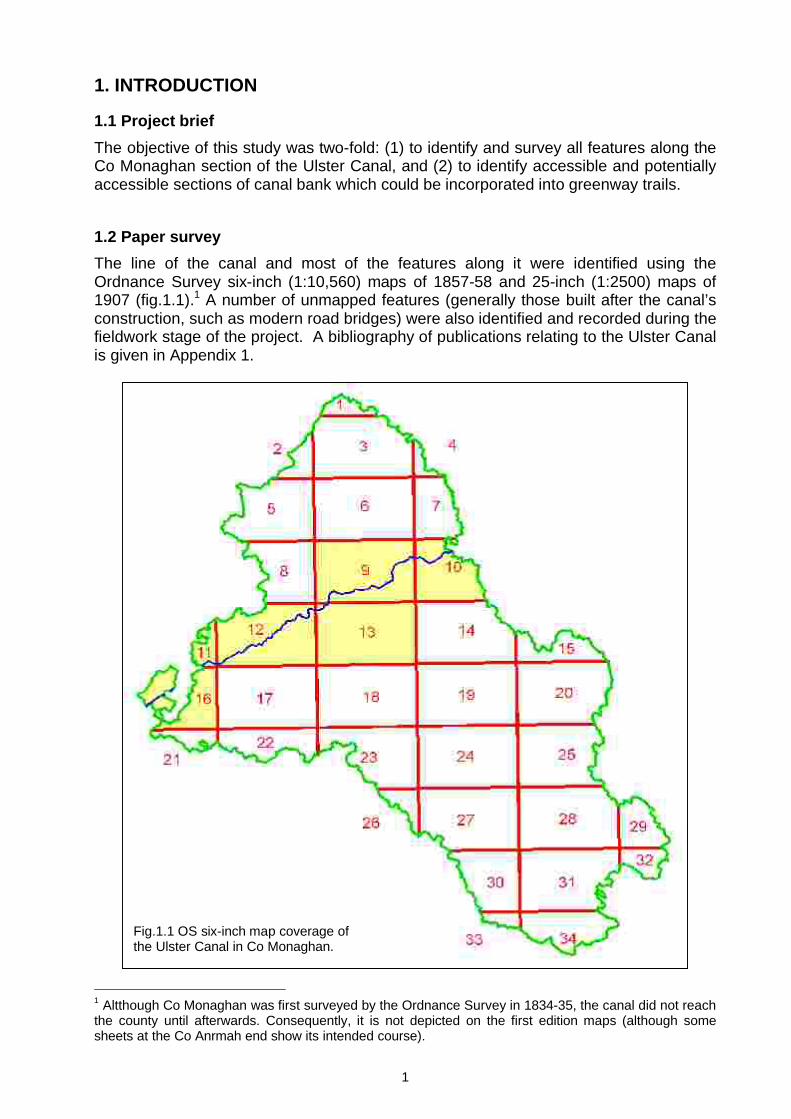
1.2 Paper surveyThe line of the canal and most of the features along it were identified using the Ordnance Survey six-inch (1:10,560) maps of 1857-58 and 25-inch (1:2500) maps of 1907 (fig.1.1).1 A number of unmapped features (generally those built after the canal’s construction, such as modern road bridges) were also identified and recorded during thefieldwork stage of the project. A bibliography of publications relating to the Ulster Canalis given in Appendix 1.
1 Altthough Co Monaghan was first surveyed by the Ordnance Survey in 1834-35, the canal did not reach the county until afterwards. Consequently, it is not depicted on the first edition maps (although some sheets at the Co Anrmah end show its intended course).
Fig.1.1 OS six-inch map coverage of the Ulster Canal in Co Monaghan.

2
1.3 Field survey The Co Monaghan section of the canal was surveyed by the author in summer 2007. The Northern Ireland section of the canal had previously been surveyed by him on behalf of the Environment & Heritage Service in 2002. The line of the canal was inspected and the physical condition of the canal bed was noted: (1) infilled/removed, (2) partly infilled, (3) open/dewatered or (4) open/watered. The conditions of the banks and towpath were also noted. Each identified feature along it was described according to standards laid down by the National Inventory of Architectural Heritage (NIAH). The feature’s present condition and current use were also noted. A glossary of technical terms used to refer to the various canal-related features is given in Appendix 2. For buildings, their size, plan form and orientation, roof profile and covering, wall materials and dressings, door and window openings, and interiors (where accessible) were recorded. For the locks, their construction materials, sluices and gate survival were noted. Their width was measured using a Leica Disto Lite, a hand-held battery-powered laser device which has a precision of 1mm. In the case of bridges, each of their structural elements - abutments, arch, spandrels, parapets, and wing walls - were described in terms of their materials, coursing, embellishment, and modifications. The overall span between the abutments was also measured, as were the channel and towpath widths. In the case of road and foot bridges, the deck width (distance between the parapets) was also noted. At least one photograph was taken using a Canon EOS 500 camera and 20-35mm lens. Film rather than digital images were taken on the grounds of long-term permanence. However, the negatives were scanned and digitised, edited using Photoshop Elements, and saved as jpeg files for inclusion in this report and accompanying DVD.
1.4 Numbering systemFor the purposes of site description and data analysis, the stretch of canal lying between two sets of locks is designated as a 'reach'. Each reach has been numbered according to the sequence of locks from the Lough Neagh end (fig 1.2). Thus, reach 0 lies between the River Blackwater and first lock at Charlemont, and reach 1 is between locks 1 and 2. The first reach in Co Monaghan is no.10, this being the number of the lock on the Co Armagh side of the Border. Reaches 10-22 are wholly or partly within Co Monaghan.
North-EastSouth-West
B’water
Finn Lock
1Lock
2Lock
3
Lock
18
Lock
19
Lock
20
Lock
21
Lock
25
Lock
26
R0R1
R2
R18R19
R20
R25R26
Fig 1.2 Reach numbering.

3
Based on their degree of survival, individual stretches were differentiated and numbered sequentially within each of the reaches, starting at their Lough Neagh ends, e.g. S1008 denotes stretch 08 on reach 10, whilst S2103 is stretch 03 on reach 21.All sites have been numbered from the Lough Neagh end according to the reach in which they lie. Thus lock 12 is feature 1201 (i.e. the first site on reach 12), and subsequent features within that reach are 1202, 1203 etc. Where a site has more than one component, the latter are differentiated by sub-numbers. For example, 1401.1 denotes the lock at site 1401, whilst 1401.2 is the associated keeper’s house. In the case of site 1708, 1708.1 is the original bridge and 1708.2 is its replacement.Each photographic image is numbered according to the site depicted, e.g. 1301_01 is image 01 at site 1301, 1301_02 is image 02 etc.
1.5 Computer databases All the data generated by the paper and field surveys were transferred to Access and MapInfo databases to facilitate analysis and retrieval using a variety of selection criteria.
Access databaseThe following data were recorded in a Microsoft Access database for reaches, stretches and sites:
ReachesAll the canal reaches within Co Monaghan were noted along with their respective lengths (as measured using MapInfo)..
StretchesAll stretches within each of the reaches were recorded as follows: Reach number. Stretch number. Survival (open/watered, open/dewatered, partly infilled, infilled/removed). Length (as measured using MapInfo). Towpath survival. Walkability of towing and offside banks.
SitesFor each feature, the following attributes were noted: Site number (and sub-numbers in the case of multi-component sites). Name. Type. Canal related? (i.e. built by Ulster Canal Company). Location (county, six-inch sheet, townland, National Grid). History. Fieldwork details (whether surveyed, and if so - survey date, surveyor, completeness,
condition, current use, detailed description).

4
Heritage evaluation (NIAH criteria/ interest categories, industrial heritage significance).
Statutory protection (existing; recommended protection for sites with a regional or national rating)
Cross-references to other databases (Waterways Ireland inventory and Louth-Monaghan railway database site numbers).
Photographs For each contemporary image, the following data were recorded: Site number. Image number. Photographer. Date taken. Caption.
Historical photographs
For each historical photograph, the above data were also recorded and also the source of the image.
All the data thus recorded were arranged in various tables, forms and reports for ease of interrogation and selection, viewing on screen, and printing out in hard-copy format.Hard-copy site indexes were also prepared for users without access to the computerised database (Appendix 3).
MapInfo databaseEach reach, stretch and site was also plotted on digitised versions of the OS maps using MapInfo. This greatly facilitated fieldwork and the analysis and presentation of the data which could be overlaid on OS Discovery (1:50,000), six-inch, and 25-inch maps and aerial photographs. The following MapInfo tables were created:
Ulster CanalLine of canal in Co Monaghan and length thereof.
Canal reachesReach number and length of each reach.
Canal stretchesReach number, stretch number, survival (colour coded), length and towpath survival.
Canal sites Site number (and sub-numbers where split into components) Type National Grid easting and northing Whether or not canal related (i.e. built by Ulster Canal Company).
Statutory protection (if any).
Heritage rating (based on documentary and field surveys).

5
1.6 Evaluation of industrial heritage significance
NIAH CriteriaThe National Inventory of Architectural Heritage uses a wide range of criteria to assessthe merits of buildings and structures: Architectural, Historical, Archaeological, Artistic, Cultural, Scientific, Technical and Social.2 For the recorded canal features, the most relevant criteria are Architectural and Historical, along with the supplementary criteria of Group value, Setting and Uniqueness/ Rarity.3
Architectural interest A building or structure may be of architectural interest on account of its design, the use and treatment of materials, workmanship, scale, composition, decorative elements, and if it is the work of a notable architect or engineer. Where alterations or additions have been made, they should not detract from the feature’s original character. A feature may also have merit if it makes a positive contribution to its setting. Moreover, even if a particular feature is of no special interest in its own right, it may have group value in enhancing the interest of the complex of which it is a part.
Historical interest A site can also be of interest in terms of what it tells us about the past. In the case of the surviving canal sites, they fall into this category on account of their association with the Ulster Canal Company and in illustrating a particular transportation system. A particular building or structure may also be a rare or unique example of its type, either because it was atypical in the first place, or is now one of the last survivors of the once typical.
Heritage ratingLevels of significance can range from Record Only (i.e. not significant), through Local, Regional and National, to International. A record only rating is generally given to a site where nothing visible exists or what survives is too incomplete to reflect its original form and function. Where only one or a few criteria are met, a local rating is usually appropriate. This rating also applies to features which would otherwise be of regional merit but which have been diminished in character by unsympathetic alterations and/or poor state of preservation. NIAH policy is not to protect such sites (although local authorities sometimes do), but planners should be aware that they have attributes which place them above the ordinary. Where a number of criteria are met, or there is something very special about a site, then a regional or even a national rating is appropriate. Following NIAH practice, sites with this rating or above are recommended for statutory protection where not already listed.
2 NIAH, 2004. Architectural Heritage Protection: Guidelines for Planning Authorities, p.24 (Dublin: Department of the Environment, Heritage and Local Government).3 Under NIAH guidelines, Group value and Setting fall within the Architectural category, and Uniqueness/Rarity under Historical. For the purposes of this evaluation, they have been separated.
6
1.7 Statutory protectionSites of special heritage significance may be accorded statutory protection against unauthorised demolition and redevelopment under the Planning & Development Act 2000, and under Section 12 of the National Monuments (Amendment) Act 1994.
Record of Protected Structures
The Planning Act generally relates to sites which are still in use or which it would be beneficial to adaptively reuse. Such sites are listed in the Record of Protected Structures (RPS) which is maintained by each local authority.
Record of Monuments and Places
The National Monuments Act is usually applied (but not exclusively) to disused monuments of pre-1700 date which merit preservation in their existing state and are probably not reusable. Prehistoric earthworks are invariably accorded this level of protection. Such sites are listed in the Record of Monuments & Places (RMP) which is maintained by the Department of Environment, Heritage and Local Government.

7
2. HISTORICAL OVERVIEWThe Ulster Canal was constructed by the Ulster Canal Company between 1831 and 1841 to link Lough Neagh with Upper Lough Erne. Starting at Charlemont, on the River Blackwater in Co Armagh, it passes Caledon, Middletown, Monaghan and Clones en route to Wattle Bridge on a navigable section of the River Finn some 6km from the Erne (fig 2.1). Its overall length is 74km (46 miles) and it cost over a quarter of a million pounds to construct. Just over 35km (22mls) lies within Co Monaghan, representing 48% of its total length.
2.1 Initial proposalsThe proposal to build a canal to connect Limerick with Belfast, via the River Shannon, was instigated by the Directors General of Inland Navigation.4 In 1814, as part of this ambitious scheme, they commissioned John Killaly, their Chief Engineer, to establish the feasibility of a route between Lough Neagh and Lough Erne.5
Since 1742, Newry had been linked by canal to Lough Neagh. Some 50 years later, in 1794, Belfast was also linked to the lough via the Lagan Canal. The Shannon was also navigable as far as Carrick-on-Shannon from 1799 onwards. If a connection could be established with the Shannon, it would then be possible to access Dublin via the Grand and Royals canal, completed in 1804 and 1817 respectively, and also Waterford via the Barrow Line, opened in 1791 (fig 2.2).
4 These historical details are based on Delany (1986) and McCutcheon (1980).5 English-born John Killaly (1766-1832) moved to Ireland in 1794 on his appointment as Assistant Engineer to the Grand Canal Company. He became the company’s Chief Engineer in 1798, a post which he held until 1810. From 1803, he also worked part-time for the Directors General of Inland Navigation. Prior to the Ulster Canal, he was involved with the construction of the Grand Canal and proposals to link the River Shannon with Lough Erne.
Fig 2.1 Route of Ulster Canal showing locks and portion within Co Monaghan (after UWG, 2003).

8
Killaly presented his report to the Directors in February 1815 with a recommendation that a 57km canal be built between Charlemont and Wattle Bridge. It was to have 22 locks of a similar gauge to the Royal Canal (the narrowest of which was 4.06m/13ft 4in).
Fig 2.2 Ireland’s canals and navigable rivers c.1835. Those extant before the opening of the Ulster Canal in 1842 are shown in blue. The course of the Ulster Canal is marked in red and the subsequent Ballinamore & Ballyconnell Canal, the final link in the system, in orange (after Delany, 1986).

9
2.2 The Ulster Canal CompanyNothing further came of the canal scheme until 1825 and the passing of “an Act for making and maintaining a navigable Canal from Lough Erne in the County of Fermanagh, to the River Blackwater, near the Village of Charlemont in the County of Armagh”. This enabled the setting up of the Ulster Canal Company and empowered it to borrow up to £100,000 from the government to make up any shortfall in private subscriptions. Killaly revised his original proposal, reducing the number of locks from 22 to 17 deeper ones and the cost from £223,000 to £160,050. The Exchequer Bill Loan Commissioners, who were responsible for any government funding, appointed the eminent English engineer Thomas Telford to examine Killaly’s new scheme. Although it met with his approval, there was a delay whilst the interest rate and size of the loan was negotiated with the government. A further delay was caused by Telford amending Killaly’s plans and increasing the number of locks from 17 to 26. Unfortunately, this change was made after the contractors - Henry, Mullins and MacMahon – had been appointed by the Canal Company. They requested £35,000 for the additional work, almost twice Telford’s £20,000 estimate. This issue could not be resolved, so the contractors withdrew from the project.
2.3 Building the canalDigging of the canal finally began in 1831 at the Charlemont end, six years after the enabling Act. The contractor was William Dargan, who subsequently became Ireland's foremost railway contractor. He was also engaged in building the Kilbeggan Branch of the Grand Canal at this time (1830-35). Thomas Casebourne was the company’s Resident Engineer, having replaced Killaly who died in 1832. William Cubitt was the company’s Consulting Engineer for most of the project, taking over in 1834 upon the death of Telford. In order to reduce costs, it had been decided to construct all the locks to a nominal width of 12ft (3.66m). Unfortunately, the minimum lock width on the Lagan and Newry canals was 15ft (4.57m). It is uncertain whether the decision to reduce those on the Ulster by 3ft, compared with those on the two principal neighbouring canals, had been made by Killaly or Telford. Either way, the ensuing short-term savings in construction costs would ultimately lead to continual expenses in transhipping goods and materials to the narrower lighters which negotiated the Ulster Canal.The canal reached Monaghan in 1838, having ascended 47.0m (154ft) in 19 locks from the River Blackwater (fig 2.3). The summit level between Monaghan and Smithborough was completed in 1840. By the autumn of the following year, the descent of 16.5m (54ft) in seven locks had been made to Wattle Bridge on the River Finn at the Lough Erne end.6 Lock 26 had the dubious distinction of being the narrowest in Ireland at only 11ft 8½in (3.57m).The canal finally opened to commercial traffic in 1842. In all, it had cost £230,000, of which just over half (£120,000) was a government loan.
6 The height of the Blackwater is c.15.25m above Ordnance Datum, the summit level is at 62.20m and the Finn is at 45.70m.

10
2.4 Canal operationThe prevailing belief amongst the canal’s promoters was that it would bring economic growth to the areas through which it passed:
“Great expectations have been raised in this district [south-east Fermanagh] of the advantages to be derived from this canal, but it remains to be seen whether they will be realised. The inhabitants complain about want of market for their produce, which the construction of this canal ought in a great measure to remove, as it will give them the means of cheap conveyance to some very large markets”.7
Unfortunately, this optimism was not to be realised as the canal was beset from itsopening by insurmountable economic and technical problems.Besides the need for all but the narrowest of lighters to tranship because of the width of the locks, it was also necessary to keep the canal topped up with water to offset natural leakage and the losses incurred through lockage. The canal's short summit length of 9.6km (13% of its total length), coupled with the small capacity of its feed reservoir on the summit level at Quig Lough, resulted in summer water shortages, particularly west of Clones.Toll receipts never came close to generating the £14,000 annual profit originally forecast. Not surprisingly, the Ulster Canal Company defaulted on its loan repayments to the government and was wound up in 1851. The canal was taken over by the Board of Works and leased to William Dargan, its builder. He operated a freight service between Enniskillen and Newry, via Lough Neagh and the Newry Canal, with onward shipments to Liverpool within the week. In 1858, faced with mounting competition from the Ulster and Dundalk & Enniskillen Railways (which reached Monaghan from Belfast and Clones from Dundalk respectively in that year), he relinquished his lease to the Dundalk Steam Navigation Company.
7 Ordnance Survey Memoir, Drummully Parish, Co Fermanagh (1835).
Fig 2.3 Longitudinal section through the Ulster Canal showing location and heights of locks. Those sections lying within Co Monaghan are highlighted in blue (after UWG, 2003).

11
They had no success either with running the canal, and it reverted to the Board of Works in 1865.1858 was also the year in which the Lower Bann Navigation opened between Lough Neagh and Coleraine. The following year the Ballinamore & Ballyconnell Canal was also completed (having started in 1846), thus establishing the final link between the Erne and Shannon (fig 2.2). The government’s grand scheme of linking Ireland’s principal cities by navigable waterways was now in place and it was now theoretically possible to navigate between the north, south, east and west coasts of Ireland entirely by water.However, these developments did not improve the commercial viability of the Ulster Canal. By then, railways were in the ascendancy and the anticipated traffic from the west of Ireland failed to materialise. Indeed, in the first ten years of its operation, the Ballinamore & Ballyconnell Canal carried only 15 vessels despite a more than adequate lock width of 16ft 6in (5.03m). Having just financed the Ballinamore Canal, the Board was understandably reluctant to abandon the Ulster. Accordingly, when the lease reverted to them in 1865, they closed the canal and embarked on an ambitious programme of improvements costing £22,000. Amongst these was the upgrading the summit level feed from Quig Lough. This entailed cutting a new channel from the River Blackwater and an additional embankment to enlarge both the lough’s area and depth.When the Board reopened the canal in 1873, traffic was still bedevilled by summer water shortages. This was exacerbated by the fact that the Ballinamore & Ballyconnell Canal had been allowed to become derelict. During the first three years of its reopening, some £3000 was spent on maintenance, whereas annual receipts were less than £500. In 1880, a government commission under Lord Monck recommended that the Ulster Canal be sold. However, no buyer could be found. Traffic did increase marginally in the early 1880s with the establishment of the Inland Carrying Company by W.R. Rea.
2.5 Demise and closureDespite huge annual losses, the Lagan Navigation Company (of which Rea was Secretary) was persuaded by the Board to take over the running of the Ulster. The passing of the Ulster Canal and Tyrone Navigation Act in 1888 enabled this transfer to take place. At the same time, the company also took over responsibility for the Coalisland Canal which linked the River Blackwater with Coalisland, Co Tyrone.Although canal traffic actually peaked in the 1890s and annual receipts rose to £700, running costs remained significantly higher than the revenue generated by lock tolls. Only the profits from the Lagan and Coalisland canals kept the company from bankruptcy. Although the section to Monaghan was passable, the onward section to Clones was only usable in the winter and early spring. Beyond Clones, the canal was unusable despite the company’s legal obligation to maintain it. Matters deteriorated further with the imposition of customs duties after the partition of Ireland in 1921. The last lighter plied the canal on 29 October 1929. It was subsequently dewatered and, in 1931, officially abandoned.

12
2.6 The situation todaySince closure, much of the canal has been sold off to the neighbouring landowners along its course. However, Monaghan County Council retains ownership of that section within its jurisdiction. Following the restoration of the link between the Shannon and Erne for recreational use in 1994, attention once again focused on the Ulster Canal as a conduit to Lough Neagh. A preliminary feasibility study commissioned by the Office of Public Works and the Northern Ireland Department of Agriculture concluded that it would be possible to reopen, albeit on a different line in places. Since 1999, responsibility for Ireland’s inland waterways, both north and south, has been in the hands of Waterways Ireland. More detailed feasibility studies have since been carried out and the Inland Waterways Association of Ireland has also been proactive in informing politicians and the general public of the social and economic benefits of its reopening. These endeavours cumulated in the announcement at a North-South Ministerial Council Meeting in July 2007 that the Clones-Erne section of the canal would be restored. Waterways Ireland has been assigned responsibility for the design and implementation of the scheme, the cost of which will be fully met by the Irish Government. Waterways Ireland will also be responsible for maintaining the restored canal and for its development, primarily for recreational use.
13
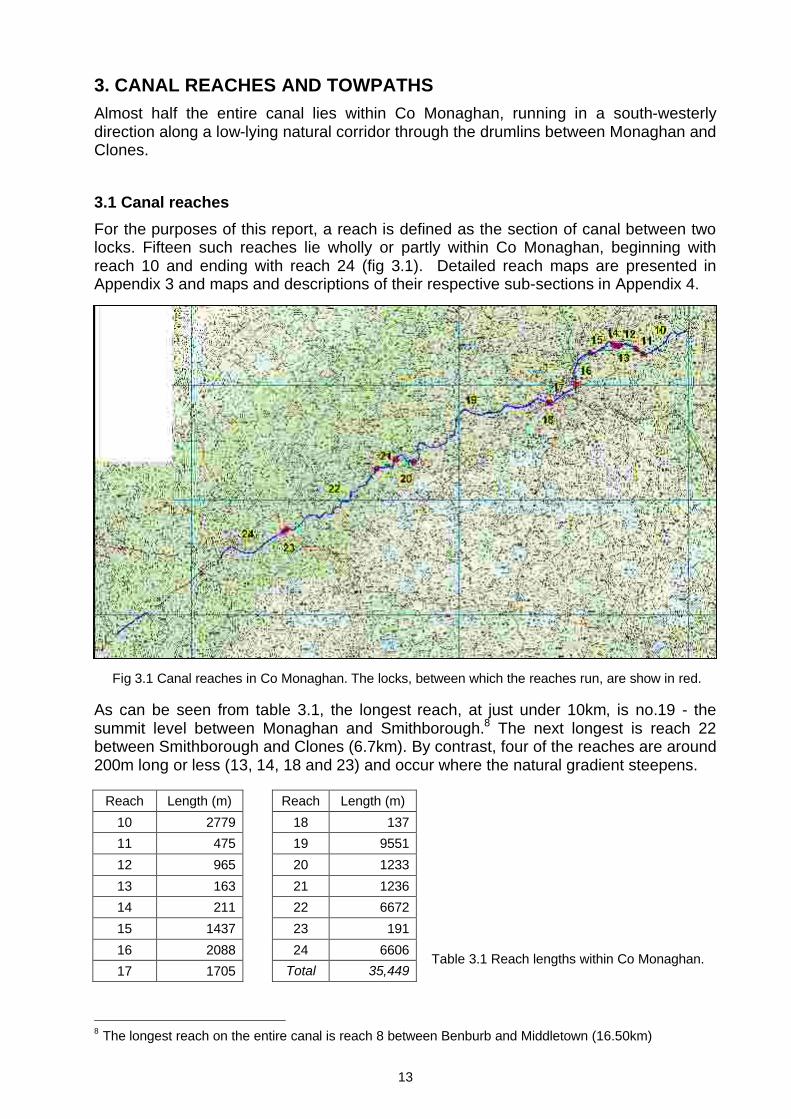
3. CANAL REACHES AND TOWPATHSAlmost half the entire canal lies within Co Monaghan, running in a south-westerly direction along a low-lying natural corridor through the drumlins between Monaghan and Clones.
3.1 Canal reachesFor the purposes of this report, a reach is defined as the section of canal between two locks. Fifteen such reaches lie wholly or partly within Co Monaghan, beginning with reach 10 and ending with reach 24 (fig 3.1). Detailed reach maps are presented in Appendix 3 and maps and descriptions of their respective sub-sections in Appendix 4.
As can be seen from table 3.1, the longest reach, at just under 10km, is no.19 - the summit level between Monaghan and Smithborough.8 The next longest is reach 22 between Smithborough and Clones (6.7km). By contrast, four of the reaches are around 200m long or less (13, 14, 18 and 23) and occur where the natural gradient steepens.
Reach Length (m) Reach Length (m)10 2779 18 13711 475 19 955112 965 20 123313 163 21 123614 211 22 667215 1437 23 19116 2088 24 660617 1705 Total 35,449
8 The longest reach on the entire canal is reach 8 between Benburb and Middletown (16.50km)
Fig 3.1 Canal reaches in Co Monaghan. The locks, between which the reaches run, are show in red.
Table 3.1 Reach lengths within Co Monaghan.

14
Fig 3.3 Slumped section of canal south of Clones (S2405).
3.2 Reach survivalGiven that the canal has been disused for almost 80 years, it is remarkable that so much has survived. Almost exactly two-thirds of the section within Co Monaghan is still open, most of it in a dewatered state (table 3.2).9 The longest continuous open stretch occurs north of Anlore (S2214 - 1.6km), followed by a stretch east of Carson’s Bridge (S1913 - 1.2km) and another east of Clones (S2401 - 1.1km).
The open dewatered sections are mostly overgrown with scrub and trees (fig 3.2). Of the four watered stretches, the two at the east end (S1006 and S1008) appear to be
maintained in that state for amenity purposes and total just over 700m. The two much longer stretches in the vicinity of Drumsnat Lake, east of Smithborough (S1917 and S1919, totalling 2.4km) are watered because a stream has been redirected along the canal bed.
Just under 8% of the canal is partly infilled. Interestingly, the six stretches where this has occurred all lie on reach 24 in the vicinity of Clones and south-west thereof
(stretches 2405, 2407, 2409, 2412, 2413, 2415). This infilling appears to be largely natural rather than deliberate, the soft peaty nature of the ground hereabouts having enabled the banks and sides to slump into the bed of the canal (fig.3.3). This probably explains why this section of canal was so difficult to navigate.
Just over one quarter of the canal within Co Monaghan has been either infilled or removed. Most of this is the result of land reclamation by farmers for agricultural purposes. The two longest such stretches are south of Smithborough (S2002 – 1.2km), and at Killycronaghan (S2203 – 1.1km). Sections have also been infilled to facilitate new road crossings and to bypass original canal bridges. The longest such road infill is in Monaghan, on the inner relief road west of Old Cross Square (S1703 – 0.8km).
9 By contrast, only 47% o f the canal within Northern Ireland is still open.
Condition Length (m) % Total lengthOpen, watered 3096 8.7Open, dewatered 20,478 57.8Partly infilled 2728 7.7Infilled/ Removed 9147 25.8Total 35,449 100
Table 3.2 Survival of canal within Co Monaghan.

15
3.3 TowpathsFor obvious reasons, the towpath follows the edge of the canal for its entire length. However, it does not always stay on the same side. Where no longer clearly visible in the field, its position can easily be determined from its citation on the OS 25-inch maps (“towing path”), and also where it passes underneath road bridges. In the case of the Co Monaghan section, exactly two-thirds is on the north and west banks, and the remainder on the south and east ones.The towpath crosses the canal at three bridges – 1708, 1908 and 2209 (fig 3.4a).10 The towpaths at these ‘cross-over’ bridges are configured in such a way that the hauling ropes did not need to be unhitched from the horses as they switched from one side of the canal to the other. The ramps up from the towpath to the road crossing came back on themselves on the other bank (fig 3.4b). Had they not, the bridge would have obstructed the rope and it would have needed to be unhitched and manhandled under the bridge and across to the opposite bank. Only bridge 2009, just east of the aqueduct over the River Finn, is still fully intact; the abutments of 1908, at the Monaghan canal stores, also survive, but 1708 is gone.
10 There was a fourth such bridge at Benburb, Co Tyrone.
Bridge 2209
Bridge 1908
Bridge 1708
From Charlemont
To Wattle Bridge
A
Towpath on south bank.
Towpath on south bank.
Towpath on north bank.
Canal
Cross-over bridge
Cross-over bridge
B
Fig 3.4 Top: Schematic map of towpath relative to the canal and cross-over bridges. Bottom: Schematic diagram of towpath and ramp configurations at cross-over bridges. The red arrows denote the direction of travel of the draught horses en route to Wattle Bridge (the arrows are reversed going the other way).
Towpath
16
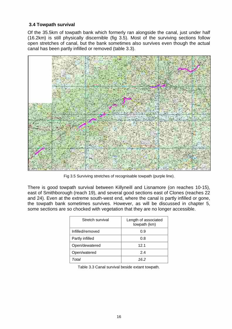
3.4 Towpath survivalOf the 35.5km of towpath bank which formerly ran alongside the canal, just under half (16.2km) is still physically discernible (fig 3.5). Most of the surviving sections follow open stretches of canal, but the bank sometimes also survives even though the actual canal has been partly infilled or removed (table 3.3).
There is good towpath survival between Killyneill and Lisnamore (on reaches 10-15), east of Smithborough (reach 19), and several good sections east of Clones (reaches 22 and 24). Even at the extreme south-west end, where the canal is partly infilled or gone, the towpath bank sometimes survives. However, as will be discussed in chapter 5, some sections are so chocked with vegetation that they are no longer accessible.
Stretch survival Length of associated towpath (km)
Infilled/removed 0.9
Partly infilled 0.8
Open/dewatered 12.1
Open/watered 2.4
Total 16.2
Table 3.3 Canal survival beside extant towpath.
Fig 3.5 Surviving stretches of recognisable towpath (purple line).

17
4. CANAL FEATURESA total of 156 features were identified at 118 sites along the Co Monaghan section of the Ulster Canal. Of these, 134 were built by the Ulster Canal Company or Board of Works. A detailed inventory is given in Appendix 5. Bridges were the most frequent type of feature, followed by lock-related ones and milestones (table 4.1). Although only four feeders were noted, 21 related buildings and structures are associated with them.
4.1 Locks Fourteen of the 26 locks lie within Co Monaghan (the rest are in Northern Ireland), and all survive in various states of repair (figs 4.1 and 4.2). Numbers 11 to 19 ascend from the Lough Neagh end to the summit level, and numbers 20-24 descend towards Lough Erne. The average change in height at each lock is 2.44m (8ft 0in). Their highest concentration is in the vicinity of Cavanreagh, where there are three locks (nos 13-15) within 380m of each other.1
1 This is matched only at Benburb, where there are six locks (nos 3-5) in the space of 400m.
Locks 14Lock-related 21Lock houses 7Road bridges 54Aqueducts 20Foot bridges 1
Bridges 76
Rail bridges 1Stores 2Offices 2
Stores and quays 8
Quays 4Milestones 21 21
Feeders 4Buildings 2Bridges 17Reservoirs 1
Feeder related 27
Other structures 3Drainage sluices 1Miscellaneous 3Pipes 2
Total 156
Table 4.1 Frequency of feature types on the Ulster Canal in Co Monaghan.
Fig 4.1 Partly infilled lock chamber at Templetate (lock 22).

18
The average width of the locks is 3.70m (12ft 2in; table 4.2). The differences between them is commensurate with the variation from top to bottom and end to end within each chamber. Taking this into account, it is evident that all the locks adhere closely to their designed standard of 3.66m (12ft 0in). This was also found to be the case with all the locks on the N. Ireland section of the canal.
Lock Width (m) Width (ft in)11 3.67 12 0012 3.78 12 0513 3.73 12 0314 3.76 12 0415 3.60 11 1016 Not measured17 3.72 12 0218 3.73 12 0319 3.64 11 1120 3.67 12 0021 3.66 12 0022 3.82 12 0623 3.63 11 1124 3.67 12 00
Average 3.70 +/- 0.06 12 02 +/- 0 02
The locks are not only virtually the same size but also of identical construction – single chambers with ashlar side walls and recesses for a pair of lock gates at each end. Although the gate emplacements are generally visible, none of the actual gates survive.
Table 4.2 Measured lock widths.
Fig 4.2 Location of locks (purple circles) and lock houses (red squares).

19
Fig 4.3 Winding gear at lock 13.
Immediately above and below the cill at the upper end of each chamber is an opening for a ground sluice by which the chamber was filled with water from the reach above. Vestiges of rack-and-pinion winding gear for these sluices survive at locks 13, 14, 21 and 22 (fig 4.3)This ground sluice arrangement is preferable to sluices on each of the breast gates as there is less turbulence within the chamber as it fills (fig 4.4). However, this is not an issue with the tail gates (as the vessel is still inside the lock), so gate sluices are used in preference to ground sluices at the bottom end of the chamber. The presence of the former are generally evident as small rectangular recesses in the breast gate emplacements. There are stop grooves at one or both ends of many ofthe chambers to enable water to be kept out during maintenance.
Most of the chambers are heavily overgrown, but locks 13, 14 and 22 are maintained by their owners as landscape features and are relatively clear of vegetation. All three have remains of sluice winding gears, whilst locks 13 and 14 also have dressed stonemooring posts.
4.2 Lock housesAlthough there are 14 locks, there are only seven lock keeper’s houses (fig 4.2 above). In four instances the lock keeper was responsible for a single lock, but in three cases he attended to several as they were in close proximity to one another (table 4.3). In the case of locks 11, 12 and 21, it is uncertain where the lock keeper lived, presuming that there was one at all.
CillGround sluices closed
Gate sluices open
Gate sluices closed
Ground sluices open
Water in chamber rises to level of
upper reach
Water in chamber falls to level of
lower reach
Lower reach
Upperreach
Fig 4.4 Schematic plan of lock chamber showing operation of ground and gate sluices.

20
Fig 4.6 Restored lock house at lock 20.
Lock house Locks served1401.2 13,14, 151601.2 161703 171801.2 18, 192001.2 202201.2 222301.2 23, 24
Unlike milestones, which were always on the towing bank, there is no consistency in the location of the houses: four are on the towpath side (1601, 1801, 2201 and 2301) and three are on the offside bank (1401, 1703 and 2001). The houses are of identical design – a single storey high by three bays in plan, with hipped slate roofs, oversailing eaves with exposed rafter tails, central octagonal stone chimney, dressed stone quoins and squared random walls (fig 4.5). The middle bay has two rooms, one of which is canted and projects outwards from the façade in the general direction of the lock. In some instances, there is also a small lean-to extension on one of the gables.
One of the houses has been demolished to make way for a modern replacement dwelling (1601.2) and another has been so thoroughly integrated into a modern house that it is no longer recognisable (1401.2). The house at lock 18 (1801.2) has been sensitively restored and extended, and retains its original external character (fig 4.6). The four remaining houses are no longer occupied and in various states of dereliction.
Table 4.3 Relationship between locks and lock houses.
Fig 4.5 Left: Abandoned lock house at lock 20. Above: Schematic plan of typical lock house.

21
4.3 Bridges There are 76 bridges along the line of the canal (excluding feeders), of which 61 were built by the Ulster Canal Company. Of the latter, 41 are road-over-canal bridges and 20 are canal-over-river bridges (aqueducts). Those not associated with the canal company comprise a railway bridge and 13 replacement or new road and foot bridges.
Original road bridgesBridges which carry public roads and accommodation tracks (to houses and fields) over the canal account for 41 of the canal company’s bridges (fig 4.7). Thirty are complete or substantially intact and all but five of these are still in use as road bridges. Of the remaining 11 bridges, three have only partial remains and eight have been demolished without trace.
All but one of the road bridges whose form is known are of masonry arch construction, with a semicircular arch spanning the canal and towpath (fig 4.8). The abutments, spandrels and parapets are generally of dressed stone blocks or squared rubble laid to courses, with out-curving wing walls at both ends. Embellishment takes the form of finely-dressed voussoirs, a string course running over the arch crown at the base of the parapets, and dressed stone parapet copings and terminal piers. Unfortunately, the faces of many of the bridges are now obscured by vegetation overgrowth.
Fig 4.7 Original road-over-canal bridges on the Co Monaghan section of the Ulster Canal.
Fig 4.8 Left: Drawing of typical canal bridge by John Killaly, c.1830. It notes that the surface width of the canal under the bridge was to be 14ft (McCutcheon, 1980, plate 19.2). Right: Leitrim Bridge (1006) is virtually identical to the drawing and typical of the road bridges along the canal.
22
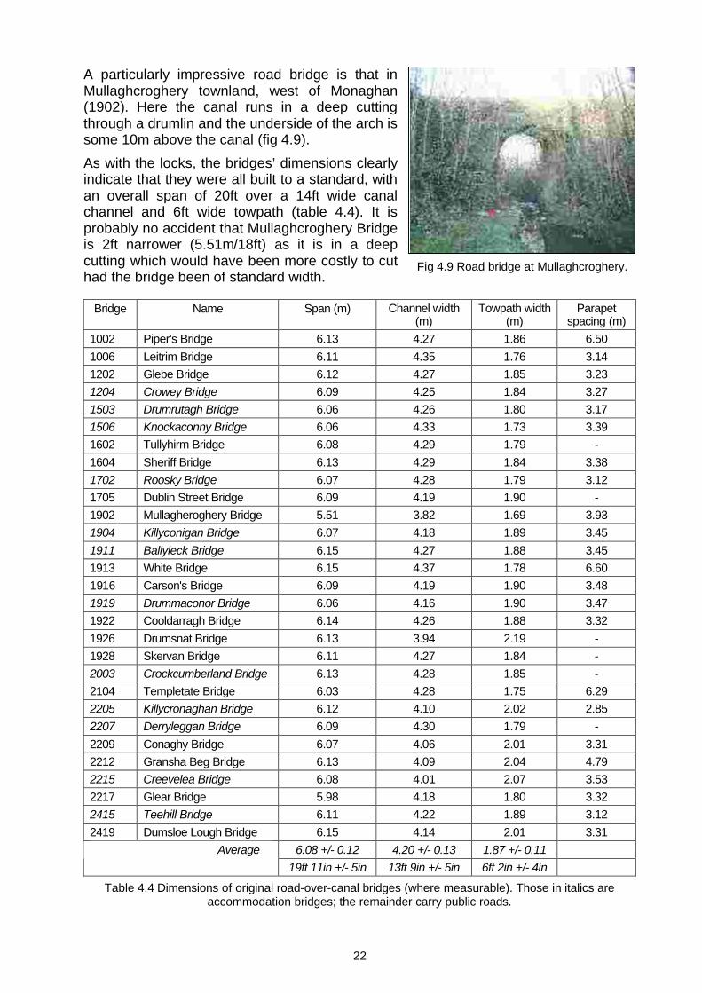
Fig 4.9 Road bridge at Mullaghcroghery.
A particularly impressive road bridge is that in Mullaghcroghery townland, west of Monaghan(1902). Here the canal runs in a deep cutting through a drumlin and the underside of the arch is some 10m above the canal (fig 4.9).As with the locks, the bridges’ dimensions clearly indicate that they were all built to a standard, with an overall span of 20ft over a 14ft wide canal channel and 6ft wide towpath (table 4.4). It is probably no accident that Mullaghcroghery Bridge is 2ft narrower (5.51m/18ft) as it is in a deep cutting which would have been more costly to cut had the bridge been of standard width.
Bridge Name Span (m) Channel width (m)
Towpath width (m)
Parapet spacing (m)
1002 Piper's Bridge 6.13 4.27 1.86 6.501006 Leitrim Bridge 6.11 4.35 1.76 3.141202 Glebe Bridge 6.12 4.27 1.85 3.231204 Crowey Bridge 6.09 4.25 1.84 3.271503 Drumrutagh Bridge 6.06 4.26 1.80 3.171506 Knockaconny Bridge 6.06 4.33 1.73 3.391602 Tullyhirm Bridge 6.08 4.29 1.79 -1604 Sheriff Bridge 6.13 4.29 1.84 3.381702 Roosky Bridge 6.07 4.28 1.79 3.121705 Dublin Street Bridge 6.09 4.19 1.90 -1902 Mullagheroghery Bridge 5.51 3.82 1.69 3.931904 Killyconigan Bridge 6.07 4.18 1.89 3.451911 Ballyleck Bridge 6.15 4.27 1.88 3.451913 White Bridge 6.15 4.37 1.78 6.601916 Carson's Bridge 6.09 4.19 1.90 3.481919 Drummaconor Bridge 6.06 4.16 1.90 3.471922 Cooldarragh Bridge 6.14 4.26 1.88 3.321926 Drumsnat Bridge 6.13 3.94 2.19 -1928 Skervan Bridge 6.11 4.27 1.84 -2003 Crockcumberland Bridge 6.13 4.28 1.85 -2104 Templetate Bridge 6.03 4.28 1.75 6.292205 Killycronaghan Bridge 6.12 4.10 2.02 2.852207 Derryleggan Bridge 6.09 4.30 1.79 -2209 Conaghy Bridge 6.07 4.06 2.01 3.312212 Gransha Beg Bridge 6.13 4.09 2.04 4.792215 Creevelea Bridge 6.08 4.01 2.07 3.532217 Glear Bridge 5.98 4.18 1.80 3.322415 Teehill Bridge 6.11 4.22 1.89 3.122419 Dumsloe Lough Bridge 6.15 4.14 2.01 3.31
6.08 +/- 0.12 4.20 +/- 0.13 1.87 +/- 0.11Average19ft 11in +/- 5in 13ft 9in +/- 5in 6ft 2in +/- 4in
Table 4.4 Dimensions of original road-over-canal bridges (where measurable). Those in italics are accommodation bridges; the remainder carry public roads.
23
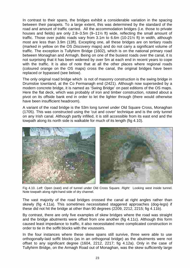
In contrast to their spans, the bridges exhibit a considerable variation in the spacing between their parapets. To a large extent, this was determined by the standard of the road and amount of traffic carried. All the accommodation bridges (i.e. those to private houses and fields) are only 2.8–3.5m (9–11½ ft) wide, reflecting the small amount of traffic. Those over public roads vary from 3.1m to 6.6m (10-21½ ft) in width, althoughmost are less than 3.9m (13ft). Excepting one, all these bridges are on tertiary roads (marked in yellow on the OS Discovery maps) and do not carry a significant volume of traffic. The exception is Tullyhirm Bridge (1602), which is on the national primary road between Monaghan and Armagh. Being on one of the busiest roads over the canal, it is not surprising that it has been widened by over 5m at each end in recent years to cope with the traffic. It is also of note that at all the other places where regional roads (coloured orange on the OS maps) cross the canal, the original bridges have been replaced or bypassed (see below).The only original road bridge which is not of masonry construction is the swing bridge in Drumsloe townland, at the Co Fermanagh end (2421). Although now superseded by a modern concrete bridge, it is named as ‘Swing Bridge’ on past editions of the OS maps. Here the flat deck, which was probably of iron and timber construction, rotated about a pivot on its offside bank end in order to let the lighter through (there would otherwise have been insufficient headroom).A variant of the road bridge is the 53m long tunnel under Old Square Cross, Monaghan (1705). This was constructed using the 'cut and cover' technique and is the only tunnel on any Irish canal. Although partly infilled, it is still accessible from its east end and the towpath along its north side is walkable for much of its length (fig 4.10).
The vast majority of the road bridges crossed the canal at right angles rather than skewly (fig 4.11a). This sometimes necessitated staggered approaches (dog-legs) if these did not hit the bridge at other than 90 degrees (2209, 2212, 2215; fig 4.11b). By contrast, there are only five examples of skew bridges where the road was straight and the bridge abutments were offset from one another (fig 4.11c). Although this form caused least impedance to traffic, it also necessitated more complicated construction in order to tie in the soffit blocks with the voussoirs. In the four instances where these skew spans still survive, three were able to use orthogonally-laid soffit blocks (as in an orthogonal bridge) as the abutments were not offset to any significant degree (1604, 2212, 2217; fig 4.12a). Only in the case of Tullyhirm Bridge, on the Armagh Road out of Monaghan, was the skew sufficiently large
Fig 4.10. Left: Open (east) end of tunnel under Old Cross Square. Right: Looking west inside tunnel. Note towpath along right-hand side of dry channel.

24
to require skewly-set soffit blocks (fig 4.12b). Even though skew soffits would have been much easier to build with brick, dressed stone blocks were the norm on all the bridges.
Three of the road bridges used by the draught horses to cross from one side of the canal to the other have already been noted in section 3.3 (1708, 1908 and 2209).Three road bridges had “ball alley” approaches, so-called because of their resemblance to ball courts (1103, 1202 and 1916). Such bridges are located on secondary roads, but very close to the main roads. As their decks are much higher than the main road, they cannot be accessed directly therefrom. Rather, ramped approaches from the main road are necessary in order to gain the necessary height to cross the canal (fig 4.13).
Fig 4.13 The ramped approach at the SW end of Tyholland Bridge (1103), with the main road at right (McCutcheon, 1980, plate 20.1).
Main road
Canal
Brid
ge
Ramp up
Fig 4.12a (left) Orthogonally-set soffit blocks at Glear Bridge (2217). Fig 4.12b (right) Skewly-set soffit blocks at Tullyhirm Bridge (1602). It was subsequently widened at both ends in concrete.
Fig 4.11 Road alignments over the canal. A. Orthogonal B. Orthogonal with dogleg C. Skew
Canal
Road

25
Only at Glebe Bridge (1202), do the ramped approaches survive, those at the other twobridges having been removed when the bridges were bypassed and the main road widened.
Aqueducts
Twenty of the bridges carry the canal over rivers, streams and drains, 12 of which survive and continue to convey active watercourses under the canal (fig 4.14).
Of the existing ones, four are constructed with flat stone lintels laid across the abutments and spanning 60-90cm (2-3ft). The remaining eight are masonry archesspanning 1.8-6.2m (6-20ft). In all but two cases, the soffits sloped down towards the middle of the canal in order to accommodate the bed (fig 4.15).
Fig 4.14 Aqueducts on the Monaghan section of the canal. The most significant ones are highlighted.
Fig 4.15 Left: Schematic cross-section and elevation of so-called ‘syphon’ bridges, where the arch crown is higher than the bed of the canal, necessitating a dropped soffit so that its intrados runs under the bed. Right: Sloping arch soffit at Ardgonnell Aqueduct over the Cor River on the Co Armagh border (1001).
Towpath
Canal
River
Arch spring line
Dropped soffit

26
Four of these aqueducts are of particular note on account of their size and/or number of spans. The Ardgonnell or Cor Aqueduct (named according to its townland or river crossed; 1001), on the border with Co Armagh, is a single arch aqueduct but has the greatest span, at 6.2m (20ft; fig 4.15 above). There are two twin-arched aqueducts –one over an unnamed stream in Cornowen townland (2202), and the other over the Lacky River at Clonfad, on the border with Co Fermanagh (2417). The spans of both of these bridges is 2.4-2.7m (8-9ft). Most impressive of all, however, is the aqueduct over the Finn River which has three 3.7m (12ft) wide spans (fig 4.16).2 In all four cases, the soffits drop towards the centre of the canal bed.
Rail bridgesThe Ulster Canal was crossed by the Dundalk & Enniskillen Railway just south-east of Clones (2407). This line opened in 1858, but the original bridge was replaced by the Great Northern Railway (Ireland) in 1925 with the present 45m long triple metal girder span. The line closed in 1959 and the actual spans removed for scrap, leaving only the bridge’s somewhat incongruous supporting columns (fig 4.17).
2 There is also a smaller triple-arch bridge of similar design over the Tynan River at Caledon.
Fig 4.16 Aqueduct over River Finn (2210).
Fig 4.17 Remains of railway bridge over Ulster Canal.

27
Modern bridges
In addition to the original road bridges, the canal is now also crossed by 13 more recent bridges, none of which were built by the Ulster Canal Company (fig 4.18). This total excludes flat culverted crossings over some of the infilled stretches of canal noted in chapter 3.
Twelve of these later bridges are road crossings. Most are of reinforced concrete construction, with one or more pipe culverts at their base to drain away any water in the canal. Five of them are replacements of original bridges (1708, 1917, 2405, 2412 and 2421) whilst a sixth bypasses an original defunct one (1916). Except for one on an accommodation road, all these replacements are on public roads (three of which are of ‘regional’ category). In all cases, they are flat crossings with little or no air draft above the canal. Such profiles are obviously less of an impedance to traffic than those original ones with curved or humped decks (fig 4.19).
Fig. 4.18 Later foot bridges (in green) and road bridges (in red) along the Ulster Canal.
Fig 4.19 The original swing bridge at Drumsloe near Clones (2421) has been replaced with this concrete culvert bridge.

28
The recent construction of a bypass around Monaghan town entailed the erection of a reinforced-concrete bridge over the canal to take account of its possible future restoration (fig 4.20). It has an overall span of 8.4m and a channel width of 6.2m (20ft). Interestingly, the latter is the same as the spans of all the original bridges and accords with restoration proposals to remove their towpaths to make the waterway 20ft wide. A timber footbridge known as Tom Young’s Bridge has also been built over the canal west of Monaghan to access a woodland walk from a car park on the opposite bank.
4.4 Stores and quaysThe two principal towns on the Co Monaghan section of the canal both had substantial stores and offices – Monaghan (1709) and Clones (2413).3 The stores are substantial two-storey buildings with two loading doorways directly on to the canal and two smaller doorways to the first floor. They both have smaller detached two-storey offices adjoining. Both buildings have been refurbished – the Monaghan one for use as a sports hall by St Louis School, and the Clones example as a visitor and community centre operated by the Clones Community Development Society Ltd (fig 4.21). There were also quays at Silverstream (1502), at Old Cross Square, Monaghan (1706), and at the former Monaghan Gasworks (1704); no traces of any of them survive.
3 There were also similar stores at Charlemeont (Co Armagh), Caledon (Co Tyrone) and Gortnacarrow (Co Fermanagh) and a transshipment store at Moy on the River Blackwater.
Fig 4.20 The new bridge over the canal on the Monaghan bypass (1603).
Fig 4.21 Monaghan canal stores (left) and Clones stores (right).

29
4.5 MilestonesThe distances from Charlemont, Caledon, Monaghan, Clones and Wattle Bridge were marked by dressed stone tablets at mile intervals along the towpath side of the canal.There are 21 known milestones, of which four still survive (fig 4.22; table 4.5).4 They were all positioned on the same side of the canal as the towpath.5
Milestone Charlemont Caledon Monaghan Clones Wattle Bridge1302 22 8 3 17 242208 [35] 21 10 4 112213 36 22 11 3 102411 3[9] 25 14 0 7
Table 4.5 Distance to principal towns as recorded on the four surviving milestones.
4.6 FeedersFeeders kept the canal topped up with water and counteracted the losses incurred through lockage, seepage and evaporation. Four are noted within the Co Monaghan stretch of the canal (fig 4.23). The summit level was the most crucial to keep topped up as it supplied both the ascending and descending reaches. Not surprisingly, therefore, three of the recorded feeders are on this level – Quig Lough (1914), a minor stream at Mullanacross (1923), and Drumsnat Lough (1924). A small feeder just west of Clones (2414) supplied reach 24.
4 There was possibly also a milestone in the vicinity of Monaghan Quay, but it is not cited on the OS 25-inch maps. It is also possible that some milestones are buried under vegetation and still await discovery. The majority have probably been removed by souvenir hunters. 5 Where no longer extant, their former positions can be determined according to whether their ‘MS’ captions on the 25-inch maps are on the north or south side of the canal.
Fig 4.22 Location of canal milestones in Co Monaghan. The four surviving ones are highlighted in red. Inset: Milestone at Clones (2411).

30
The spring-fed Quig Lough is the canal’s principal feeder and was harnessed from the outset (fig 4.24). An embankment was built across its southern end to increase itscapacity and facilitate its regulation of water into the canal. It was augmented with water abstracted from a water-powered corn mill in Bellanode which was supplied from the River Blackwater.
As noted in section 2.4, the Board of works carried out improvements to the lough between 1865 and 1873 in order to increase its capacity. These works included the construction of a new weir on the Blackwater, the bypassing of the millrace with a new channel running parallel to it, and a new embankment just downstream from the original one (fig 4.25). Further along again, a sluice house and sluice keeper's house were also constructed.
Fig 4.24 Quig Lough as viewed from northern end.
Fig 4.23 Location of feeders (in red) supplying the Co Monaghan section of the Ulster Canal (blue).

31
Although the Blackwater has now been dredged, substantial remains of the weir still survive. Both embankments at the south end of Quig Lough are long gone, allowing it to revert to its original form. The sluice house and keeper’s house also survive, albeit in a ruinous state (fig 4.26). Elsewhere along the feeder, it is crossed by a disused railway bridge on the Monaghan-Clones section of the Ulster Railway (1914.12) and two road bridges which are still in use (1914.13, 1914.14).
Fig. 4.25 Quig Lough feeder showing weir, original dam (1) and 1860s dam (2). The area shaded yellow marks the original extent of the refurbished reservoir, but it has since reverted to its original extent as a natural lough (shown in blue). The blue squares are associated structures.

32
4.7 Miscellaneous features
Drainage sluice
North east of Anlore, in the townland of Gransha Beg, the canal comes very close to the River Finn. A small sluice (2211) was inserted across the bank between the two watercourses to enable reach 22 to be drained for maintenance purposes.
Pipes
Two modern pipes cross the canal - at Killyconigan, west of Monaghan (1907), and at Teehill, south-west of Clones (2416).
Fig 4.26 Sluice house (left) and keeper’s house (right) below Quig Lough.

33
5. CANAL PROTECTIONAs noted in section 3.2, one-third of the Co Monaghan section of the canal has been removed or wholly/partly infilled. Moreover, of the 134 features related to the Ulster Canal Company, 43 are now gone or have left only minor traces – an attrition rate ofalmost one-third as well. The main casualties are milestones (17 missing), road bridges (8) and aqueducts (8). If those remains of special heritage significance are to survive, their inclusion in the Record of Monuments & Places and/or Record of Protected Structures (detailed in section 1.7) may be appropriate. It is recognised that such forms of statutory protection do not guarantee the survival of such features, particularly disused and derelict buildings and bridges. However, they will at least provide a planning tool to counteract their demolition and unsympathetic alteration, and also provide a mechanism for their long-term management as planning permission must be sought for any works thereto.
5.1 Protecting the line of the canalAt the moment, the only section of canal which has statutory protection is that between White Bridge (1913) and Carson’s Bridge (1916.1), At 1.2km long, this section (S1913) represents a mere 3% of the Monaghan section of canal. It is recommended that the entire line be similarly protected, both to prevent open sections from being infilled and to ensure that those stretches which have already been infilled are not built over with permanent structures. The RPS has been invoked for one small section of canal and the inclusion of the rest of the canal in this record is suggested. Alternatively, the Record of Monuments & Places might be more appropriate given the canal’s monumental nature.
5.2 Protecting canal featuresAt the moment, only three canal-related sites are listed in the Co Monaghan Record of Protected Structures (RPS): 1001 Ardgonnell Aqueduct over the Cor River on the boundary with Co Armagh
(RPS 41401008). 1913 White Bridge (RPS 41400953). 1916.1 Carson’s Bridge (also RPS 41400953).
As described in section 1.6 of this report, all the identified features along the canal were evaluated with regard to their heritage interest categories. The three sites which are already protected were rated as being of ‘regional’ significance and certainly justify their current listing. However, a large number of other features were found to be of equally special significance, primarily on account of their architectural and historical interest. Of the 156 identified site components, 70 were of no heritage significance, 27 were of local interest, 57 of regional interest and two of national interest. As noted earlier, features of regional and national significance merit consideration for statutory protection. Excluding the three previously mentioned features already protected, 56 additional ones merit consideration for protection, i.e. just over one-third (36%) of those identified.

34
Of these proposed sites, six are recommended for the Record of Monuments & Places: four comprise all the surviving milestones and two are associated with the Quig Lough feeder (table 5.1).
The remaining 50 features are recommended for inclusion the RPS: 26 of these are bridges (24 are road-over-canal bridges and two are aqueducts), 14 are locks (nos 11-24 inclusive), three are lock houses, four are canal offices/stores, and three relate to the feed control installation south of Quig Lough (table 5.2)
Feature Name Type Completeness Condition Use Interest categories
Signif-icance
1302 Mile marker Complete Good Disused Architectural; Historical; Rarity
Regional
1914.1 Quig Lough feeder
Canal feeder Substantial remains
Poor Disused Historical; Group
Regional
1914.8.1 Quig Lough Reservoir
Canal feeder reservoir
Substantial remains
Good Disused Historical; Group; Setting
Regional
2208 Mile marker Complete Fair Disused Architectural; Historical; Rarity
Regional
2213 Mile marker Complete Fair Disused None Regional
2411 Mile marker Complete Fair Disused Architectural; Historical; Rarity
Regional
Table 5.1 Proposed features to be considered for the Record of Monuments & Places.
Feature Name Type Completeness Condition Use Interest categories
Signif-icance
1002 Piper's Bridge Road bridge Complete Good Road bridge
Architectural; Historical
Regional
1006 Leitrim Bridge Road bridge Complete Fair Disused Architectural; Historical
Regional
1101 Lock 11; Tuckmilltate Lock
Lock Substantial remains
Fair Disused Architectural; Historical
Regional
1201 Lock 12; Tullylish Lock
Lock Substantial remains
Fair Disused Architectural; Historical
Regional
1202 Glebe Bridge Road bridge Complete Good Road bridge
Architectural; Historical
Regional
1204 Crowey Bridge Road bridge Complete Good Road bridge
Architectural; Historical
Regional
1301 Lock 13; Crowey East Lock
Lock Substantial remains
Fair Disused Architectural; Historical
Regional
1401.1 Lock 14; Crowey West Lock
Lock Substantial remains
Fair Disused Architectural; Historical
Regional
1501 Lock 15; Siverstream Lock
Lock Substantial remains
Fair Disused Architectural; Historical
Regional

35
1503 Drumrutagh Bridge
Road bridge Complete Fair Road bridge
Architectural; Historical
Regional
1506 Knockaconny Bridge
Road bridge Complete Fair Road bridge
Architectural; Historical
Regional
1601.1 Lock 16; Knockaconny Lock
Lock Substantial remains
Fair Disused Architectural; Historical
Regional
1604 Sheriff Bridge Road bridge Complete Fair Road bridge
Architectural; Historical
Regional
1701 Lock 17; Asylum Lock
Lock Substantial remains
Fair Disused Architectural; Historical
Regional
1702 Roosky Bridge
Road bridge Complete Fair Road bridge
Architectural; Historical
Regional
1703 Lock house Complete Fair Disused Architectural; Historical
Regional
1705 Canal Bridge; Dublin Street Bridge
Road bridge (tunnel)
Substantial remains
Good Road bridge
Architectural; Historical; Rarity
National
1709.1 Canal store Complete Good School Architectural; Historical; Group; Setting
Regional
1709.2
Monaghan Stores
Canal office Complete Good School Architectural; Historical; Group
Regional
1801.1 Lock 18 Lock Substantial remains
Fair Disused Architectural; Historical; Group
Regional
1901 Lock 19; Tully West Lock
Lock Substantial remains
Fair Disused Architectural; Historical; Group
Regional
1902 Mullagherogh-ery Bridge
Road bridge Complete Good Road bridge
Architectural; Historical; Setting
Regional
1904 Killyconigan Bridge
Road bridge Complete Good Road bridge
Architectural; Historical
Regional
1911 Ballyleck Bridge
Road bridge Complete Fair Road bridge
Architectural; Historical
Regional
1914.8.4 Embankment Complete Good Disused Historical; Group; Setting
Regional
1914.8.5 Sluice house Substantial remains
Fair Disused Architectural; Historical; Group
Regional
1914.8.6
Quig Lough
Sluice keeper's house
Substantial remains
Poor Disused Historical; Group
Regional
1919 Drummaconor Bridge
Road bridge Complete Fair Road bridge
Architectural; Historical
Regional
1922 Cooldarragh Bridge
Road bridge Complete Fair Road bridge
Architectural; Historical
Regional
1928 Skervan Bridge
Road bridge Complete Fair Disused Architectural; Historical
Regional
2001.1 Lock 20; Killykeeragh Lock
Lock Substantial remains
Fair Disused Architectural; Historical; Group
Regional

36
2001.2 Lock house Complete Poor Disused Architectural; Historical; Group
Regional
2101.1 Lock 21; Cockcumber-land Lock
Lock Substantial remains
Poor Disused Architectural; Historical
Regional
2104 Templetate Bridge
Road bridge Complete Fair Road bridge
Architectural; Historical
Regional
2201.1 Lock 22; Templetate Lock
Lock Substantial remains
Fair Disused Architectural; Historical;Group
Regional
2205 Killycron-aghan Bridge
Road bridge Complete Poor Road bridge
Architectural; Historical
Regional
2207 Derryleggan Bridge
Road bridge Complete Poor Disused Architectural; Historical
Regional
2209 Conaghy Bridge
Road bridge Complete Good Road bridge
Architectural; Historical
Regional
2210 Finn Aqueduct Aqueduct Complete Good Road bridge
Architectural; Historical; Setting
National
2212 Gransha Beg Bridge
Road bridge Complete Good Road bridge
Architectural; Historical
Regional
2215 Creevelea Bridge
Road bridge Complete Fair Road bridge
Architectural; Historical
Regional
2217 Glear Bridge Road bridge Complete Fair Road bridge
Architectural; Historical
Regional
2301.1 Lock Substantial remains
Fair Disused Architectural; Historical; Group
Regional
2301.2
Lock 23; Glear East Lock
Lock house Complete Fair Disused Architectural; Historical; Group
Regional
2401 Lock 24; Glear West Lock
Lock Substantial remains
Fair Disused Architectural; Historical; Group
Regional
2413.1 Canal store Complete Good Offices Architectural; Historical; Group; Setting
Regional
2413.2
Clones Stores
Canal office Complete Poor Disused Architectural; Historical; Group; Setting
Regional
2415 Teehill Bridge Road bridge Complete Good Road bridge
Architectural; Historical
Regional
2417 Clonfad Aqueduct; Lackey Aqueduct
Aqueduct Complete Fair Disused Architectural; Historical
Regional
2419 Dumsloe Lough Bridge
Road bridge Complete Good Road bridge
Architectural; Historical
Regional
Table 5.2 Proposed features to be considered for the Record of Protected Structures.The two sites highlighted in red are of national industrial heritage significance.

37
The locations of the above sites, both those already protected and the ones recommended for protection, are shown in fig 5.1.
Fig 5.1 Sites of heritage significance on the Ulster Canal. Key: Purple = features and stretches listed in the RPS; Red diamond = unprotected feature of regional interest; Green square = unprotected feature of national importance.

38
6. CANAL ACCESS
6.1 Current accessAs noted in section 3.4, some 16km of the towpath survives intact. However, almost 6km of this is no longer accessible due to dense vegetation overgrowth blocking the way. A further 4km is also walkable in places although the actual towing bank has disappeared. Almost 15km is therefore walkable on the towpath side, representing 41% of its original total length in Co Monaghan (table 6.1).
Sections of the opposite bank are also walkable in places. As table 6.2 shows, 6.3km is accessible on both sides of the canal, and 6.6km on the offside bank only. The total length of canal which is accessible along one or both sides is therefore 21.3km (14.7km + 6.6km), representing 60% of its line within the county.
Although well over half the canal is walkable, the general public does not necessarily have a right of way over all such stretches. Some sections of towpath have been taken into private occupation or can only be accessed across private land. Moreover, the reclamation of much of the offside bank for agricultural use may also give rise to practical difficulties in accessing walkable stretches on this side. Public roads follow the line of the canal for much of reaches 10, 11, 12 (Monaghan-Armagh), some of the summit level (Monaghan-Clones), and south-west of Clones (Clones- Cavan). Because of the volume and speed of the traffic, however, such roads afford little more than cursory drive-by glances at the canal and are quite unsuited to pedestrians and cyclists. Some 1.5km of public tertiary road gives relatively undisturbed access to the canal, along with 0.5km of pubic footpath (fig 6.1). However, only two of these stretches are continuous with one another, and none is more than 600m long. Public access to the canal is clearly a major issue given that only about 5% of the Monaghan section can presently be easily accessed by the pubic without question.That the corridor of the Ulster Canal has enormous potential for pedestrians and cyclistshas recently been recognised with the launch of the Ulster Canal Cycle Trail, a 77km road-based route between Maghery (Co Armagh) and Clones. Given its name, one might assume this trail to follow the actual canal for much of its length. However, within Co Monaghan, it touches upon the canal at only two crossing points. Moreover, although it runs parallel with the canal between Monaghan and Clones, it is some 2km away from it.6 The convoluted route of the cycle trail serves to emphasise the need for greater public access along the actual line of the canal.
6 The Ulster Canal is also crossed by the Kingfisher Trail to the south of Clones.
Towpath Bank extant Bank gone Total
Walkable 10.6 4.1 14.7
Not walkable 5.7 15.1 20.8
Table 6.1 Walkability of towpath side of canal (km).
Towpath walkable Towpath not walkable Total
Offside bank walkable 6.3 6.6 12.9
Offside bank not walkable 8.4 14.2 22.6
Table 6.2 Walkability of offside bank (km).

39
6.2 GreenwaysRecent government approval for the restoration of the Clones - Wattle Bridge section of the canal has certainly increased the public’s awareness of its existence.7 Once this initial phase is completed, it is anticipated that the rest of the line will also be restored. Whilst this will obviously make the section west of Clones publicly accessible once again, restoration of the remainder is probably many years away. Given that most of the entire canal will remain in its present state for the foreseeable future, it is not unreasonable to suggest that efforts be made to improve public access to those sections not earmarked for immediate restoration. A cost-effective way of doing this would be through the creation of greenways. These traffic-free trails are used by pedestrians and cyclists and have been successfully created over the past decade along the defunct Lagan, Newry and Coalisland canals.The creation of new paths along the canal will undoubtedly be easier to achieve from a practical point of view along the towpath side of the canal rather than its offside bank. To maximise cost-effectiveness, it is suggested that the following criteria be applied: (1) the towpath bank must still exist, (2) the canal alongside it must still be open (whether watered or dewatered is immaterial), (3) there must be public access from at least one end, (4) it should be of a reasonably uninterrupted length. Five sections meet the above criteria (fig 6.2).
7 It is proposed to cut a new route from just upstream of lock 25 to the River Finn via Drummully Lough in order to avoid the Cavan-Clones road and the need to construct several new bridges.
Fig 6.1 Publicly accessible roads (orange) and footpaths (purple) on the Monaghan section of the canal.

40
1. Killyneill - Crowe Bridge greenway
This section runs from St Patrick’s Church at Killyneill to Crow Bridge via Tyholland (fig 6.3). It encompasses stretches S1106 to S1201 inclusive and measures 2.2km, of which 0.7km is watered and only 33m is infilled. A number of locks and bridges survive along it, or can be observed just beyond its ends (table 6.1).
Fig 6.2 Proposed greenways (in red) along the line of the Ulster Canal in Co Monaghan.
Fig 6.3 Killyneill-Crowey Bridge greenway (in red) and associated surviving features (blue).
1 km

41
Site Site name Type Completeness Condition Use1005 Aqueduct Complete Fair Disused1006 Leitrim Bridge Road bridge Complete Fair Disused1101 Lock 11; Tuckmilltate Lock Lock Substantial remains Fair Disused1102 Aqueduct Complete Good Disused1103 Tyholland Bridge Road bridge Some remains Poor Disused1201 Lock 12; Tullylish Lock Lock Substantial remains Fair Disused1202 Glebe Bridge Road bridge Complete Good Road bridge1204 Crowey Bridge Road bridge Complete Good Road bridge1301 Lock 13; Crowey East Lock Lock Substantial remains Fair Disused1302 Milestone Complete Good Disused
Table 6.1 Features on the Killyneill–Crowey greenway. Italicized sites are visible beyond both ends.
2. Monaghan Town greenway
This section makes use of an already existing public footpath along the south (offside) bank of the canal east of Dawson Street Bridge (a former cross-over bridge). It continues westwards over the main road to a short stretch of private access road leading to St Louis School. It then runs along the towpath on the south bank as far as lock 19 (fig 6.4). It encompasses stretches S1704, 1705 and 1801 and is 0.8km long, all of it open and dewatered. Beyond lock 19, the towpath is partly blocked, but by continuing along a minor road, the impressive cutting through a drumlin and the tall road bridge (1902) across it become evident. It would then be possible to return to the start of the walk by crossing this bridge and following along the Clones Road back into town.
1 km
Fig 6.4 Monaghan Town greenway (in red) and associated surviving features (blue).

42
Two locks, a lock house and Monaghan Stores can all be seen along this section of canal. A short distance beyond the north-east end of this greenway, the unique tunnel under Old Cross Square (1705) is also easily accessible (table 6.2).
Site Site name Type Completeness Condition Use1705 Dublin Street Bridge Road bridge Substantial remains Good Road bridge1708.1 Dawson Street Bridge Road bridge Traces N/A N/A1709 Monaghan Stores Canal stores Complete Good School1801.1 Lock 18 Lock Substantial remains Fair Disused1801.2 Lock house Complete Good Dwelling
1901 Lock 19; Tully West Lock Lock Substantial remains Fair Disused1902 Mullagheroghery Bridge Road bridge Complete Good Road bridge
Table 6.2 Features on the Monaghan Town greenway. Italicized sites can be seen beyond both ends.
3. Smithborough greenwayThis section lies south-east of Smithborough and runs from Drumsnat Bridge to lock 20 beyond Skervan Bridge. It encompasses stretches S1919-1921 and is 2.4km long (fig 6.5). The section between the two bridges has a stream running through it. A minor road crosses a short infilled section south of Skervan Bridge and can be followed to a track along the canal which leads to lock 20 and its associated keeper’s house.
Fig 6.3 Smithborough greenway (in red) and associated surviving features (blue).
1 km

43
Apart from the above features on this section, the picturesquely situated Drumsnat Lough is accessible at the north-east end. Immediately beyond lock 20, a culvert carries an active stream under the canal (table 6.3).
Site Site name Type Completeness Condition Use1924 Drumsnat Lough Canal feeder Complete Good Disused1926 Drumsnat Bridge Road bridge Complete Fair Road bridge1928 Skervan Bridge Road bridge Complete Fair Disused2001.1 Lock 20; Killykeeragh Lock Lock Substantial remains Fair Disused2001.2 Lock house Complete Poor Disused
2002 Aqueduct Complete Poor Disused
Table 6.3 Features on the Smithborough greenway. Italicized sites can be seen beyond both ends.
4. Derryleggan greenway
This section is situated off a minor road to the south–east of Stone Bridge. Because the stretch beyond its north-east (Monaghan) end is infilled and only accessible across private land, it is best approached from the public road at its south-west end, near where it crosses the Finn River. It is 1.6km long and takes in sections S2004-2010 (fig 6.4). Except for three small infilled sections totalling c.50m in length, it is entirely open and dewatered. Moreover, the well defined towpath along its north bank is easily negotiable in its present state.
Three road bridges and a small aqueduct can be seen along this greenway, including the only surviving cross-over bridge on the Monaghan section of canal (2209). By following the metalled minor road westwards for a short distance beyond the latter, the
Fig 6.4 Derryleggan greenway (in red) and associated surviving features (blue).
1 km
44
triple-arched Finn Aqueduct is crossed. A clear view of it is to be had once round the sharp bend where the road diverges from the canal. One of four intact milestones is also on this section (table 6.4).
Site Site name Type Completeness Condition Use2205 Killycronaghan Bridge Road bridge Complete Poor Road bridge2206 Aqueduct Complete Fair Disused
2207 Derryleggan Bridge Road bridge Complete Poor Disused2208 Mile marker Complete Fair Disused
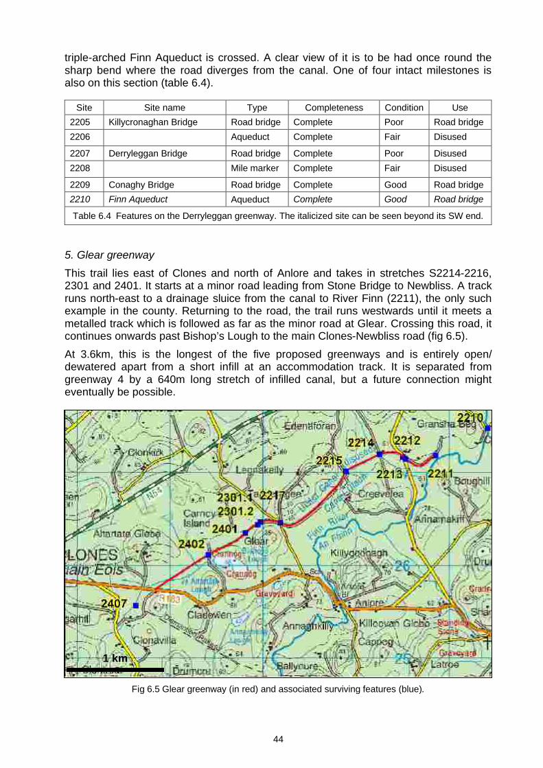
2209 Conaghy Bridge Road bridge Complete Good Road bridge2210 Finn Aqueduct Aqueduct Complete Good Road bridge
Table 6.4 Features on the Derryleggan greenway. The italicized site can be seen beyond its SW end.
5. Glear greenway
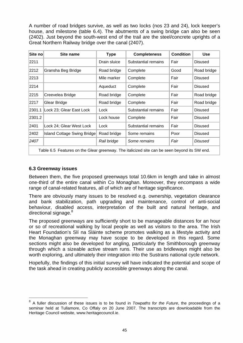
This trail lies east of Clones and north of Anlore and takes in stretches S2214-2216, 2301 and 2401. It starts at a minor road leading from Stone Bridge to Newbliss. A track runs north-east to a drainage sluice from the canal to River Finn (2211), the only such example in the county. Returning to the road, the trail runs westwards until it meets a metalled track which is followed as far as the minor road at Glear. Crossing this road, it continues onwards past Bishop’s Lough to the main Clones-Newbliss road (fig 6.5). At 3.6km, this is the longest of the five proposed greenways and is entirely open/ dewatered apart from a short infill at an accommodation track. It is separated from greenway 4 by a 640m long stretch of infilled canal, but a future connection might eventually be possible.
Fig 6.5 Glear greenway (in red) and associated surviving features (blue).
1 km
45
A number of road bridges survive, as well as two locks (nos 23 and 24), lock keeper’s house, and milestone (table 6.4). The abutments of a swing bridge can also be seen (2402). Just beyond the south-west end of the trail are the steel/concrete uprights of a Great Northern Railway bridge over the canal (2407).
Site no Site name Type Completeness Condition Use
2211 Drain sluice Substantial remains Fair Disused
2212 Gransha Beg Bridge Road bridge Complete Good Road bridge
2213 Mile marker Complete Fair Disused
2214 Aqueduct Complete Fair Disused
2215 Creevelea Bridge Road bridge Complete Fair Road bridge
2217 Glear Bridge Road bridge Complete Fair Road bridge
2301.1 Lock 23; Glear East Lock Lock Substantial remains Fair Disused
2301.2 Lock house Complete Fair Disused
2401 Lock 24; Glear West Lock Lock Substantial remains Fair Disused
2402 Island Cottage Swing Bridge Road bridge Some remains Poor Disused
2407 Rail bridge Some remains Fair Disused
Table 6.5 Features on the Glear greenway. The italicized site can be seen beyond its SW end.
6.3 Greenway issuesBetween them, the five proposed greenways total 10.6km in length and take in almost one-third of the entire canal within Co Monaghan. Moreover, they encompass a wide range of canal-related features, all of which are of heritage significance.There are obviously many issues to be resolved e.g. ownership, vegetation clearance and bank stabilization, path upgrading and maintenance, control of anti-social behaviour, disabled access, interpretation of the built and natural heritage, and directional signage.8
The proposed greenways are sufficiently short to be manageable distances for an hour or so of recreational walking by local people as well as visitors to the area. The Irish Heart Foundation’s Slí na Sláinte scheme promotes walking as a lifestyle activity and the Monaghan greenway may have scope to be developed in this regard. Some sections might also be developed for angling, particularly the Smithborough greenway through which a sizeable active stream runs. Their use as bridleways might also be worth exploring, and ultimately their integration into the Sustrans national cycle network. Hopefully, the findings of this initial survey will have indicated the potential and scope of the task ahead in creating publicly accessible greenways along the canal.
8 A fuller discussion of these issues is to be found in Towpaths for the Future, the proceedings of a seminar held at Tullamore, Co Offaly on 20 June 2007. The transcripts are downloadable from the Heritage Council website, www.heritagecouncil.ie.

46
7. CONCLUSIONSGiven the recent government announcement that part of the Ulster Canal is to be restored, this baseline survey of its Co Monaghan section comes at a timely moment. Although long abandoned, two-thirds of the 35km section of canal within the county survives in an open, albeit overgrown, state of preservation. The towing bank is also recognisable for about half its length. However, only a very small stretch is currently protected against removal or infilling in the Record of Protected Structures. Given the canal’s historic importance as the penultimate link in the grand scheme for a navigable waterway between Belfast and Limerick, it is recommended that its entire line within the county also be protected, perhaps through inclusion in the Record of Monuments and Places.Some 156 features were recorded along the canal, of which 134 were built by the Ulster Canal Company or Board of Works. Of these, 59 were evaluated as being of regional or national industrial heritage significance. Only three currently enjoy statutory protection and it is recommended that the remaining 56 be likewise protected – six through inclusion in the Record of Monuments & Places, and 50 in the Record of Protected Structures. Enjoyment and appreciation of the canal is hindered by the fact that walkable public roads and footpaths pass alongside it for less than 6% of its length. There is, however, potential to create a number of vehicle-free paths (greenways) along its route for recreational use by pedestrians and cyclists. Five greenways are proposed here - in the vicinity of Killyneill, Monaghan Town, Smithborough, Derryleggan and Glear. With a combined length of almost 11km, they take in 30% of the line of the Co Monaghan section of the canal as well as many original features of heritage interest en route. It should be emphasised that the above recommendations, particularly those relating to statutory protection, are not made with the intent of hindering any future restoration of the canal. Rather, their purpose is to ensure that the canal and its related features are material considerations in any such proposals and are designed to ensure that those features of special industrial heritage significance are safeguarded for posterity.