an applied ontology for semantics associated with · pdf filean applied ontology for semantics...
TRANSCRIPT

An Applied Ontology for Semantics Associated with Surface Water Features
Dalia E. Varanka
E. Lynn Usery
U.S. Geological Survey
ABSTRACT Surface water land cover plays a major role in a range of geographic studies,
including climate cycles, landform generation, and human natural resource use settlement.
Extensive surface water data resources exist from geographic information systems (GIS), remote
sensing, and real-time hydrologic monitoring technologies. An applied ontology for surface
water was designed to create an information framework to relate data in disparate formats. The
objective for this project was to test whether concepts derived from a GIS hydrographic data
model based on cartographic relational table attribute data can be formalized for semantic
technology and to examine what differences are evident using the ontology for database semantic
specification. The surface water ontology (SWO) was initially derived from the National
Hydrography Dataset (NHD) GIS data model. The hypothesis was that ontology semantics can
be consistent with a long-term empirically collected database. An automated conversion of
classes and properties was then manually refined with the support of an upper ontology. The
results were tested for reliable class associations, inferred information, and queries using
SPARQL Protocol and RDF Query Language (SPARQL). The ontology reflects studies of the
physical environment, the objectives of the supporting institution, the reuse of GIS, and the
adaptation of semantic technology. The results contribute to the development of an ontology
model that leverages large data volumes with information user access.
KEYWORDS: geospatial ontology, hydrography, semantic technology
x.1 Introduction
Surface water accumulates in depressions on the earth’s surface at geographic scales,
persists for periods of time, and flows or recedes over the surface as a function of elevation.
Surface water is a primary category of human environmental interest; its study and

representation as land cover has a long history. The charting of surface water crosses cultures,
technologies, and symbolic languages. The recognition of surface water features results in part
from the direct experience of the environment, such as from overland travel, but because features
at the geographical scale can become too broad to easily see, then ideas of landscape often result
from the study of geographical texts and maps. Varying criteria are possible for categorizing and
labeling surface water entities in texts. For example, waterbodies may persist over a period of
time, or appear periodically or intermittently due to movement through seepage, replenishment
by precipitation, or loss through evaporation. In many cases, the specific meaning of categories
become ambiguous when separated from their context or defined by different groups of users.
Ontology is the study of what exists, and findings from this branch of philosophy can be
applied to guide the design of data models. A central objective of applied ontology is to specify
semantic information about data that usually remain within a broader context of knowledge and
experience of users, or are represented in texts such as writing or graphic sources. Such
knowledge is not encoded as part of the data but provided cognitively by the user during
database interaction. Such contextual semantics are difficult to include as coherently reasoned
media because they are technically incompatible with GIS databases, the conceptual
developments of which are based on expanding the capabilities of mapping by manipulating
related data attribute tables.
The National Hydrography Dataset (NHD), the surface water component of The National
Map of the U.S. Geological Survey (USGS), is one such GIS database (USGS 2014a; USGS
2014b). The NHD is the digital version of the surface water theme appearing on topographic
maps of the United States since the late 19th century. The data were collected according to
surveying instructions, both from field and aerial photography sources, and converted from maps
to digital vector data in the late 20th century. The NHD is centrally maintained with information
edits from state partners, resulting in a complex technical design that has been developed over a
century by an extensive user community. An ontology design for surface water data and its
integration with empirical data as a semantic technology system is expected to improve the
clarity of surface water data such as the NHD. In turn, empirical data are needed to validate
ontological surface water concepts.
The objective of this paper is to present the development of a surface water ontology for
semantic technology that reflects information about real-world entities and leverages legacy

databases aligned with a different technical data model. The vision for the ontology is that its
future application by users would aid accessibility to the data. The approach is to build semantic
concepts with ontology modeling practices upon a foundation of NHD data as they were
developed through extensive hydrographic modeling practice, and secondly, to test whether this
surface water ontology, which will be called SWO, can be used to clarify the NHD semantics
that were not supported or were often confusing in GIS. Typical of GIS, the NHD data model
consists of numerous tables defining feature classes in various forms: as points, lines, and areas;
as feature domains (types); events; the Water Boundary Dataset (WBD); attribute tables;
metadata; and processing domains. The hypothesis is that a semantic approach will clarify these
tables, making them more categorically aligned with the expectations of users. This will be
achieved by reorganizing the geometrically constrained data categories, clarifying codes, and
relating similar concepts to reduce redundancy while still supporting semantic detail.
The sections of this paper are organized as follows. Section 2 is a review of significant
literature on applied surface water ontology, and the approach is briefly summarized in section 3.
Section 4 details the development of the SWO ontology. The steps included the automated
conversion of NHD data from GIS to Resource Description Framework (RDF) triples that
resulted in an ontology called GIS NHD and the manual refinement of the GIS NHD as the SWO
(Cyganiak and others 2014). The SWO follows top-level knowledge models, including upper
ontology and surface water science. The SWO has an instance database component organized as
gazetteer. Section 5 describes testing the SWO by applying reasoning to the ontology for inferred
triple statements and section 6 describes information retrieval using use case queries with
competency questions and SPARQL graph patterns. The ontology application is followed by
discussion and conclusion. The digital ontology file is available on the Internet (Varanka 2014).
x.2 Literature
An ontology design is abstracted from the context of a subject at varying levels, including
the physical world; cultural abstractions represented through language; quantitative, science, and
logic models; upper ontology concepts; and technical implementations. Research contributions
have been made towards these aspects of surface water ontology, though toward different
objectives and with varying parameters. The results of some key studies are summarized in this
section.
The study of semantics normally begins with natural language. In a major systematic
linguistic analysis, the lexical term “body of water” was parsed into English- language synsets by
the WordNet project (Princeton University 2014). Body of water was assigned to domain
categories of river, lake, and ocean, and related with two predominant properties, type and parts,
to broader or narrower classes. Synonyms of terms are grouped into unordered sets. This synset
provides a basic level of surface water semantics, but excludes important spatial and temporal
relations, and provides other no context for each term than a natural language definition (gloss).
Synsets are designed for computational linguistics and natural language processing, related to
semantic technology, but different in its focus on informal terms rather than formal variables and
relations; terms in semantic technology are arbitrarily assigned labels.
Though language is an important source for ontological analysis and resolution,
linguistically derived ontology will lead to several inconsistencies because terms vary for reasons
such as cultural and geographic difference, geographic scale, or technological approach.
Research in multi- lingual categorization indicates the complexity of drawing equivalent or
related classes for data integration or interoperability of multi- language spatial data
infrastructures (Feng and Sorokine 2014; Duce and Janowicz 2010). Though these studies
confirm the variability in the concepts used to distinguish water features between languages and
cultures, some qualities, such as shape and size differentiation, may be widely recognized across
cultures.
A hydrology ontology published by the British Ordnance Survey (OS) is like SWO in
being rooted in national topographic data sources. The files list extensive geospatial feature types
as primitive classes with spatial relation properties, Web Ontology Language (OWL) axioms,
and annotations to help clarify the semantics (OS 2008; Hart and Dolbear 2012; W3C OWL
Working Group 2012). The ontologies are supported by reasoning software. Most terms,
however, rely on information derived from natural language with few defined classes that
specify class criteria based on ontological analysis. Because a large number of information
queries are satisfied by identifying the taxonomic type of a geospatial feature, hierarchy and
subsumption play a central role in ontology development and function. Taxonomic specification
is limited, however, with a single property between primitive, meaning basic, terms. Primitive

terms alone are insufficient in specifying the relations forming a complex proposition formed by
multiple related properties. Without a formally defined framework involving properties such as
parts or specifically identified properties for the application, an ontology composed of
predominantly natural language terms lacks sufficient specificity and equivalence for the
operation of inference.
Ontologies aim to resolve semantic variability by creating restrictions on category criteria
that reflect complex relations. Among these could be aspects of physical reality based on direct
observation or experience of the world, such as size, shape, and material. Property restrictions to
include spatial semantics could be functions such as navigation, force dynamics such as water
flow or metric values such as hydrographic shape or size. For example, an ontology of Cree
hydrography specified geospatial feature pairs, such as big brother/little brother lakes (Wellen
and Sieber 2013). Quantitative methods have been applied for surface water ontology design.
Santos and Bennett (2005) used formal concept analysis to create a concept lattice of object
attribute ranges for the water domain; shape, size, flow, depth, and origin. Supervaluation
semantics are applied to model threshold-value variability (Bennett 2001). This approach differs
from the development of ontology from cognitive or experiential derived observation, where
specifics can be applied at the instance level. The automatic classification of quantitative data
helps builds ontology by identifying salient qualities from reoccurring instances of a pre-selected
object.
Hydrographic ontology requires further logical restrictions based on systematically
organized science principles concerning surface water features. For example, the objective of
EnvO is the formalization of environmental ontology (EnvO 2013). In the EnvO ontology,
surface water is a subclass of water and environmental material. EnvO has a class called
hydrographic feature, defined as “a geographical feature associated with water” with 22
subclasses. Unfortunately, variability, even among scientists, persists. Synonyms for
Hydrographic Feature include Fluvial Feature, Marine Feature, Tidal Rip, Upwelling, Eddy, and
Overfalls; these classes are not synonyms with each other. Some of these terms could arguably
be called superclasses of feature events; others could be events rather than features of an
enduring type. Some sibling classes include mixed surface water/terrain features types, such as
island, inlet, coast, harbor, but also include biological elements to surface water such as algal

bloom or causes, such as beaver dam, and engineered features such as wells, which are
subsurface water.
The extension of spatial representation to other science ontologies is an important
function of a surface water ontology. The realmHydroBody module of the Semantic Web for
Earth and Environmental Terminology (SWEET) ontologies has mostly hydrologic classes and
properties, such as MethaneIce, with some included hydrographic features, such as Floodbank
(SWEET 2013). The class Coastal, sharing the EquivalentTo property with CoastalRegion, for
example, has sibling classes consisting of mechanical and chemical hydrology, imported from
other separate modules. Spatial aspects are needed to support the realmHydroBody ontology.
Hahmann and Brodaric (2012) clarified aspects of hydro-ontology by formalizing spatial
voids, primarily holes and gaps that help define the integration of surface and subsurface parts of
hydrogeology. Voids define areas within the earth’s surface or other physical materials that host
surface water . A top-level ontology was used to establish rules for earth/water spatial properties
within voids. The demonstrated research of the paper specifically focuses on groundwater
formalizations, but that can also apply to the creation and persistence of surface water areas or
features within their terrain hosts for surface water. Upper ontology also guided a surface
hydrologic ontology developed with the Basic Formal Ontology for the design of a hydro
ontology (Feng and others 2004).
A surface water ontology pattern published by Sinha and others (2014) is composed of
two essential modules, one representing earth surface terrain that supports the accumulation and
flow of water, called a dry model, and the second representing surface water and its properties,
called a wet model. The central focus of the ontology is that the dry model influences the shape
of the water bodies and water courses in the wet model, but water flow and pooling, and flow
direction is modeled in the wet model. The nature of a pattern is that as a small ontology,
reasoning may be complete within the pattern, but is incomplete when expanded to specific
applied situations (Gangemi and Presutti 2010). For example, though channels need incline to be
on a path of greatest descent, elevation and slope are not implied in the Dry Model, nor are
obstructions and natural or artificial diversions such as dams or rapids. These exclusions are
partially because other inputs for determining flow and pooling are possible, such as
groundwater rise and rainfall. Instances of fluence, an object class defined in the ontology
pattern roughly representing surface water flow, would normally include ‘micro’ features, such

as water turbulence, mixing of water qualities such as temperature, etc., or the extension of a
feature into a topologically joined feature, such as the movement of a river beyond the ocean
coastline. Such micro-features are not accounted for by the pattern, nor are events such as flood
conditions. Also, there are no prescriptive directions for feature geometry, for example, whether
a channel should be represented as a line or linear feature with width. However, the presence of
features may be scale independent, so the basic ontology model is not affected greatly this way.
Surface water ontologies have contributed linguistic propositions, quantitatively
measured morphology, earth science dynamics, and formal logic designs to surface water
studies. The SWO allows for these ontological sources, and adds the benefit of technical
integration with GIS and a large empirical database. An approach to creating a stable ontology
that systematically organizes extensive data must allow repeated application with changing
empirical detail and is sufficiently abstract so that inference relations produce intuitively true
statements. These goals, used in the approach to develop the SWO, are detailed below.
x.3 Approach
Classes and properties for the SWO were initially converted directly from the GIS data
model of NHD to enable the capture of all concepts considered to be relevant to the database
users and to capture all legacy data. This initial version of the SWO is called GIS NHD. In
addition to classes and properties, many domain and range sets were identified based on the GIS
attribute table. GIS NHD was manually aligned with top-level concepts, particularly upper
ontologies, geographic theory, and data model design. The SWO is characteristic of descriptive
logic, involving classes, instances, and properties, and first order logic, such as domain and range
classes (Pease 2011). Restrictions were applied to surface water domain-level classes and
properties, such as hydrographic feature types, surface water flow processes, and spatial and
temporal constraints.
The resulting version of the ontology was validated by producing inferred triples using
SPARQL Inference Notation (SPIN) and examining the results to see if they seem reasonable.
Two use cases and corresponding competency questions and SPARQL queries were developed
to demonstrate capabilities for retrieving data that could be particularly challenging using GIS.
These were ‘What types of waterbodies are subject to inundation?’ and ‘What is the temporality
of surface water flow associated with particular terrain feature types?.’ Lastly, the project is
discussed and conclusions drawn.
x.4 Surface Water Ontology
x.4.1 GIS NHD
The initial trial triple data were converted directly from GIS relational tables to the RDF
triple data mode by a custom designed program creating subjects from unique identifiers of rows,
properties from column headings, and objects from cell values (Mattli 2013). Output triples of
data from The National Map use Resource Description Framework Schema (RDFS) and Web
Ontology Language (OWL) vocabulary terms in addition to RDF (Brickley and Guha 2014).
Universal Resource Identifiers (URIs) are assigned to each resource and can be found in the
header of the RDF document. The relational data model of NHD stores segments of the spatial
geometry of features as unique rows in a database table, but the conversion program creates
geometry objects in Well Known Text (WKT) format for GeoSPARQL standard compatability.
The sample dataset includes almost all NHD classes and properties, but is not an exact replica of
NHD data at any specific time or version. The NHD data model changes and inconsistencies may
occur between the data model and dataset documentation.
After the sample dataset was converted, it served as a starting point for further ontology
development (Viers 2012). No URIs were created for table row groupings of geometry feature
classes – point, line, and polygon –because the instance triples in the ontology, which is not
constrained by geometry; were reorganize into topographic feature classes. In addition to feature
instances created by the conversion program, however, tables specifying the column formats
were manually converted to domain and range classes for NHD properties as part of the
ontology. This allowed all instances, that is, rows with unique identifiers that share the same
generated attribute values to be part of the domain class that restricts the instances the property
can draw upon to serve as the subject. For example, the NHD table called
NHDVerticalRelationship describes three column headings available to any instance that
participates in a vertical relationship, where one feature crosses over another feature. The
relationship itself has an ID (Permanent_Identifier), the feature above has an ID

(Above_Permanent_Identifier) and the feature below has an ID (Below_Permanent_Identifier).
Those three attributes were converted to properties to connect subjects to the possible or allowed
object values, for example belowPermanentIdentifier. By establishing NHDVerticalRelationship
as the domain class for belowPermanentIdentifier, only members of NHDVertical_Relationship
are useable subjects for that property.
Because the conversion resulted in the creation of hundreds of properties, a subset of data
triples was selected to focus on the specific question of surface water feature types. Though the
design and recognition of feature types and classes are highly cognitive, implementations to
support geospatial data analysis involves technical specification as well. Classes and properties
without geospatial qualities, such as source data identification, were not considered. Much of the
information that is unspecified in SWO was moved to other modules where they could be linked
to other major ontologies used within the semantic technology community, such as one of
several well-established provenance, metadata, or business systems ontologies (Fig. 1).
Important linkages exist for dimension and measurement units, such as the OGC Observations &
Measurements ontology; to provenance ontologies such as PROV-O; and others (Cox 2011;
Lebo and others 2013). No software is known for ontology-driven mapping, but data can be
exported to the Geography Markup Language (GML) to be digitally mapped.

Fig. 1. Surface Water ontology layers and ancillary modules
New classes and properties were created only when essential and missing from the many column
headings that were converted to properties from the GIS NHD model. The need for new triple
resources was usually because of unspecified assumptions in the database or the lack of
properties due to the tabular design of GIS rather than graphs.
x.4.2 Top Level Concepts
Though top-level principles are relatively independent of more specific subject domains,
guidelines from upper ontology, geographic theory, and general database design principles
provided insight to more specific surface water ontology classes and properties. Upper
ontologies were used to provide guidance for forming the taxonomic order. Geographic
concepts, such as elevation measurement, provided insight to interrelations between entities.
Database design was more relevant to the instance gazetteer.
Upper ontology formalizations specify the relations between material objects and non-
material concepts and their attributes, such as qualities, roles, and the processes within which
they engage. These general rules then apply to subject-specific subclasses and sub-properties
through inference, the inheritance of relations through the transitive property. Two documented
upper ontologies were used, the Basic Formal Ontology (BFO) and the Suggested Upper Merged
Ontology (SUMO) (Smith 2014; Pease 2011). For more intuitive understanding of the ontology
described in this paper, some upper ontology concepts were renamed to more specifically
indicate spatial surface water land cover concepts. The natural language term is rather arbitrary
because the ontology resource is defined by the formal logic.
Every triple resource (subject, property, or object) representing an entity takes the
conventional form of a qualified name, meaning a prefix to indicate the Universal Resource
Identifier separated from the class, property, or instance name by a colon. For example, BFO
uses bfo as the prefix for its qualified names, so an example of a class name from that ontology is
bfo:Entity. Class and property names of the SWO described in this paper omit the prefix and use
just the colon before the resource name, as in :flow, to indicate that SWO is the default ontology

being referenced. Class names begin with upper case letters and property names begin in lower
case letters.
The surface water feature concept is defined by two general parts; topography, meaning
the solid earth, and surface waterflow. When a drop of rainwater falls on the land, it flows
downslope toward a singular water feature accommodated on and within the terrain, such as a
stream. Surface water then flows downstream; no matter what juncture it comes to, the stream
continues along the most straight-forward channel. SWO accommodates feature classes at this
general level of the NHD and the included WBD. A characteristic of the NHD is that it includes
many earth surface-type classes, such as a :Diversion channel. The WBD centers data on nested
hydrologic unit, such as a basin, subbasin, or watershed. Modifications of the earth surface that
affect the collection of water as NHD features are indicated by a class called :HU_Mod,
indicating a type of modification to natural overland flow such as :UrbanArea or
:SpecialCondition subclasses such as :Glacier or :Karst. The terrain features described in this
paper will be the NHD surface features, and not those of the WBD.
BFO class definitions were used to reorganize the surface water concepts along ontology
principles. The results were subgroups that encompass a large number of hydrologic feature
types and properties. These classes include the earth surface formations indicated as :Feature
(equivalent to bfo:MaterialEntity) with subtypes :Object and :ObjectAggregate. Surface water is
indicated as :Flow (equivalent to bfo:Process), including standing water and hydrological events
such as damming. The class :SpatialExtent (related to bfo:SpatialRegion) includes
:SpatialQuality, :SpatialRelation, and :SpatialMeasurementUnit subclasses. :Temporality
(equivalent to bfo:TemporalRegion) has subclasses :Ephemeral, :Intermittent, :Perennial,
:Regulated, and :Status. SWO includes bfo:Function, a class for socially defined areas serving a
role by virtue of their dispositions (not depicted in Fig. 2). This class was included to link to
separate, but related graphs, such as for land use or the role of surface water in other ontologies.
These superclasses include many subclasses in the digital file that are too numerous to include in
this paper, though some specific examples are discussed in the following sections.

Fig. 2. Top-level Surface Water Ontology classes for land cover.
The diagram indicates the solid material components that are characterized by form and
spatial extents (continuants) and fluid materials that are characterized by processes and temporal
change (occurrents). This distinction is not completely disjoint, in that solid materials that
interface with water are not completely static. Debris flows, landslides, and glaciers are examples
of solid earth change affected by surface water. This specific interaction is not described in the
SWO.
Ontology models allow for greater specification of feature qualities, roles, and relative
spatial positions. In determining these specifics, a common problem was identifying the
primitive terms that were combined in NHD attribute names to specify two or more classes at
once, such as, areaAcres (area in acres) or DEDEM10 (Drainage-enforced 10-meter Digital
Elevation Model). A balance was struck between splitting such terms whenever possible to
increase the reuse of classes and to reduce database redundancy and maintaining attribute names
for linking to NHD data.
x.4.2.1 Feature
Geographical or geospatial feature type is a term that is widely used in geospatial analysis
literature, standards, and database design (Usery 2014). A feature is a relatively stable entity and
so for the SWO, the term is classified as equivalent to the structures that support the collection
and flow of water, such as terrain or engineered channels and basins. The class :Feature is a
subclass of bfo:Material Entity and conceptualizes a real-world material object in time and space,
but infers additional semantics from the geographical literature. Feature type class semantic
specifications apply to its subclasses :Object and :ObjectAggregate, a distinction that also
appears in SUMO. These Feature subclasses allow for distinctions to identify material objects
that are normally separated by spatial gaps, such as one single stream channel from others, from
aggregates of objects, such as rocks of a reef or an area of complex channels. Object instances
have cardinality normally restricted to one. :ObjectAggregate instances could have a restriction
allowing for one group or many members. This distinction between an object and aggregated
object allows, for example, the differentiation between a single dredged channel and other non-
dredged channels of a braided stream river. Though bfo:FiatObjectPart was not used, the
meronymy property :partOf, that allows objects such as a bay or inlet with a bona fide or fiat
separation from an otherwise singular entity such as a sea, was added to the class of object
properties.
x.4.2.2 Spatial Extent
Surface water often involves spatial extent as a criterion for classification. The class
:SpatialExtent is related to bfo:SpatialRegion, but bfo:SpatialRegion is represented by spatial
coordinates, and :SpatialExtent includes relative and qualitative spatial representation; the SWO
class for spatial coordinates is called :Geometry within the instance gazetteer. Upper ontologies
lack broad guidelines of spatial and geographic theory for spatial extents that can be found in
geographic information science literature. The subclasses devised for :SpatialExtent are:
:SpatialQuality, such as :Area or :Length; :SpatialRelation, such as :Elevation; and
:SpatialMeasurementUnit, such as :Acre.
A distinction was drawn between spatial qualities of objects and spatial measurements. If
a term was a spatial dimension of an object, such as length, this class or property was treated as a
quality. If a spatial relation exists between objects whose computation is based on spatial
coordinates, such as distance, then that entity was classified as a spatial relation. The actual
measurement is a specific value for each instance and is documented in the gazetteer. The
:SpatialQuality class includes geometric dimension classes, :Length and :Area, that are applied to
features in general. :SpatialMeasurementUnit includes :Acre, :Kilometer, :SquareKilometer,
:Meter, and :SquareMeter. These subclasses are available in commonly used ontologies and can
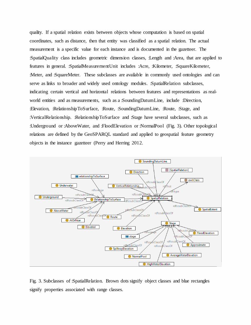
serve as links to broader and widely used ontology modules. :SpatialRelation subclasses,
indicating certain vertical and horizontal relations between features and representations as real-
world entities and as measurements, such as a :SoundingDatumLine, include :Direction,
:Elevation, :RelationshipToSurface, :Route, :SoundingDatumLine, :Route, :Stage, and
:VerticalRelationship. :RelationshipToSurface and :Stage have several subclasses, such as
:Underground or :AboveWater, and :FloodElevation or :NormalPool (Fig. 3). Other topological
relations are defined by the GeoSPARQL standard and applied to geospatial feature geometry
objects in the instance gazetteer (Perry and Herring 2012.
Fig. 3. Subclasses of :SpatialRelation. Brown dots signify object classes and blue rectangles
signify properties associated with range classes.
Surface water features have physical qualities that can lead to socially defined functions
and roles, perhaps particularly true for engineered features designed and built for a purpose. A
class called :Function is related to bfo:RealizeableEntity, with criteria that if a particular feature
bearing a quality, role, disposition, or function is removed, the feature may be changed, but
continues to exist. The SWO :Function class links to classes such as NHD :HazardZone or
:SpecialUseZone found in a separate graph.
:Feature and :SpatialExtent classes focus on hydrographic entities of temporal endurance,
relative to the more changeable temporality of surface water. The qualities of surface water and
temporality are discussed in the next section.
x.4.2.3 Flow and Temporality
A :Flow class was designed separately from the :Feature class for modeling temporal
processes such as :Waterbody and :Event. BFO defines bfo:Process as a bfo:Occurrent, an entity
with temporal parameters that for some time is dependent on some material-entity participant to
play itself out, that in this case is the water. Processes are weakly modeled in GIS relative to
continuant entities defined primarily by their spatial ranges, so relations between these classes
were drawn more from surface water science domain knowledge (USGS 2014c).
:Flow is the class of features consisting of water and flow dynamics. :Event is a subclass
of :Flow consisting of hydrological monitoring types associated with particular features, such as
:Dam or :Divergence. :Event is a class to integrate with possible hydrology ontologies.
:Waterbody has subclasses for spatial parameters with regard to the terrain, such as :Rapids,
:SinkOrRise, :SpringOrSeep, or :Waterfall. A much smaller number of such features are named
compared to the number of :Feature subclasses. :Temporality, representing the temporal aspects
of processes as defined in BFO, includes :Ephemeral, :Intermittent, :Perennial, :Regulated, and
:Status, meaning a state of being.
x.4.3 Gazetteer Ontology
The gazetteer, or database, of the ontology consists of classes, but differs from the feature
type taxonomy because categories are sets of instances and not subtypes. For example, the class
:Name is a collection of instances of names, not a taxonomy of types of names. One
characteristic of this difference is that subtypes of a parent class must be mutually exclusive, but
instances may be members of more than one subclass.
A gazetteer consist of traditional categories; :Names (toponyms), :Geometry (spatial
coordinates), and :Identifier, but added to these in the SWO is the :Hydro_Net class, which is the
entire coordinate geometry network created by all the combined geospatial features in the
selected dataset when a subset of the NHD is downloaded from the national database. Gazetteer
classes, being sets of instances, and properties, relating to instances, were mostly taken directly
from the GIS NHD ontology. The taxomony of surface water land cover required ontological
reorganization that could be modeled as a graph, but once those classes were specified, sets of
instances fell in place along the ontology design. This is a benefit of building ‘bottom-up,’ that
is, starting the ontology with the GIS database. The feature type and gazetteer instance modules
are interconnected using properties between classes. The gazetteer includes a great number of
properties for instances. Most of the feature ontology properties are object properties, drawing
relations between continuant entities, but the majority of properties in the gazetteer are datatype
properties, storing specific values for instances. Though many triple model object resources of
instances in the gazetteer ontology take the form of literals, the creation of an object class in the
feature ontology is required to define them as instances of sets. For example, the :Geometry class
contains the objects of the :hasGeometry property.
A class within the Hydro_Net called :HydroNetJunction is a set of NHD vector nodes
forming junctions of different features in the geometry network. These junctions support surface
water flow modeling. Flow modeling and watershed boundaries, forming nested hydrological
units, have transitive properties that are compatible with inference. According to the Strahler
Stream Order, if a first order stream feeds to a second order stream, and if the second order
stream flows to a third order stream, then the first order stream flows to the third order stream
(Strahler 1952). Within the WBD, subwatersheds are units contained within watersheds, and
watersheds are contained within basins, then subwatershed are contained within basins. The
inferred data from the Hydro_Net can be queried to trace a :Route along multiple stream

segments and linkages from one point on the network to points downstream. These relations are
calculated ‘on-the-fly’ using GeoSPARQL topological relation analysis.
For the SWO as a whole, the more specific the subclasses of those aligned with upper
ontology, the more semantic specification was required. In addition to asserted classes, the
effective use of inference is a key objective for the surface water domain ontology. Different
methods are available for specifying semantics and inference, among these are formal proofs
(Hitzler and others 2010), graphic representations (Allemang and Hendler 2011), and an
expressive language such as ISO Common Logic (ISO/IEC 2007). Although logical proofs
capture the details of the algorithms and graphic representations do not, graphics were used for
this study, as in examples are shown below, because of their clarity for anticipating inference
processes. Formalizations were left to the ontology, triplestore, and reasoning software.
x.5 Inference
Inference can be executed using the subsumption relation between owl:Class and
rdfs:subClassOf, setting domain and range classes for properties, OWL axioms, defined classes
using the property owl:equivalentTo, and using other restrictions such as cardinality. The top-
level classes described in this paper so far form a taxonomic hierarchy of primitive or asserted
classes. A primitive class, using the subsumption (type-of) relation between parent and child
classes, is defined in ontology as having necessary, but not sufficient conditions to support
inference. To support inference, classes must be converted to defined classes, having necessary
and sufficient conditions. This is indicated by specifying an equivalent-to relation between triple
resources. The :Flow subclass :Waterbody was converted to a defined class equivalent to the
intersection of :Flow and one of the :Waterbody subtypes (The list of subtypes appearing below
includes only a few of the eleven possible.)
:Waterbody owl:equivalentTo :Flow and (:Rapids or :SinkOrRise or :SpringOrSeep or
:Waterfall)
After applying reasoning software to the ontology, new triples were defined indicating class
membership through the transitive property. The following triple for :Waterbody is inferred:

:Waterbody rdfs:subClassOf (:Waterbody or :Event)
Rather than adding additional taxonomic classes to the ontology to expand perceived
distinctions, e.g., engineered from natural feature types, the goal is to specify the formal
semantics of each defined class to indicate the criteria by which subclasses vary. Feature types
should cluster in the graph according to restrictions rather than additional taxonomic definitions.
The number of classes was kept as small as possible to focus on key ontology properties.
Nevertheless, the :FeatureObject class is particularly large, including engineered objects with
operational parts, such as :LockChamber; natural objects with complex criteria, such as
:SwampOrMarsh; and simple objects consisting of a single type of matter, such as
:EarthenMaterial. The specifications for various defined classes are not fully established yet for
the ontology as a whole, but some individual examples are described below. These limited
semantics are partially to quickly complete initial drafts and will be addressed in later edits, and
partially to facilitate sharing mutual natural language semantics with other hydrography datasets.
As a result, many of the classes are simply terms for named entities and require further logic
specification.
x.5.1 Feature Class Semantics
The SWO has a greater number of triple resources to model than can be described in this
paper. This section presents models for two specific feature type classes, :InundationArea (Fig.
4), defined by the NHD as “An area of land subject to flooding” and :AreaToBeSubmerged (Fig.
5), defined as “The known extent of the intended lake that will be created behind a dam under
construction” (USGS 2014c). These two classes are chosen because of their similar, but slightly
different semantics for :spatialExtent and :flow.
To model :InundationArea and :AreaToBeSubmerged, both were first identified as
features. Features have certain dispositions based on internal physical qualities of the entities in
question, as is so with :InundationArea and :AreaToBeSubmerged; flooding is only possible if
the surface water height exceeds flood elevation. The two types of features differ in their effects
by external influences, as may reflect uncontrolled natural forces or controlled human decisions

and actions. With :InundationArea and with :AreaToBeSubmerged, a consequence is assumed,
but for one site intermittent inundation from variable water flow and for the other, permanent
submersion from damming. For both models, the potential presence of surface water is assumed.
Fig. 4. A semantic model for the class :InundationArea.
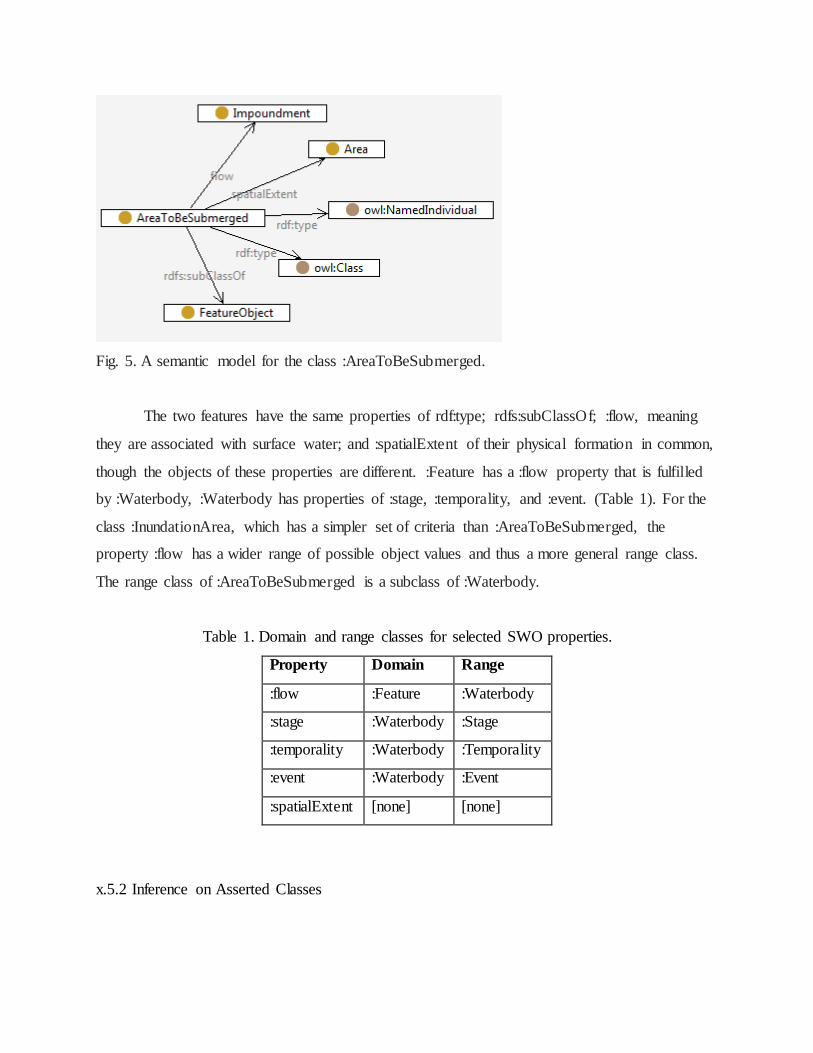
Fig. 5. A semantic model for the class :AreaToBeSubmerged.
The two features have the same properties of rdf:type; rdfs:subClassOf; :flow, meaning
they are associated with surface water; and :spatialExtent of their physical formation in common,
though the objects of these properties are different. :Feature has a :flow property that is fulfilled
by :Waterbody, :Waterbody has properties of :stage, :temporality, and :event. (Table 1). For the
class :InundationArea, which has a simpler set of criteria than :AreaToBeSubmerged, the
property :flow has a wider range of possible object values and thus a more general range class.
The range class of :AreaToBeSubmerged is a subclass of :Waterbody.
Table 1. Domain and range classes for selected SWO properties.
Property Domain Range
:flow :Feature :Waterbody
:stage :Waterbody :Stage
:temporality :Waterbody :Temporality
:event :Waterbody :Event
:spatialExtent [none] [none]
x.5.2 Inference on Asserted Classes

The inference engine executed using SWO was SPARQL Inferencing Notation (SPIN).
SPIN is a RDF vocabulary that formalizes constraints using SPARQL. SPIN is an expressive
way to formalize rules that will apply to classes (Knublauch 2011). The results indicated in
Table 1 are inferred triples produced from asserted classes. Inferred triples based on the semantic
graphs for InundationArea, indicated in Fig. 4, and AreaToBeSubmerged, indicated in Fig. 5 are
included in the results listed in Fig. 6, together with sibling and other classes of the SWO.
Inferencing at this step of ontology development demonstrates that some restrictions are declared
by the RDF and RDFS vocabulary. For example, by declaring a domain and a range class for a property,
several inferences are invoked. The subject of the statement will be inferred to be an instance of the
class in the domain of the property and the object of the statement will be inferred to be an
instance of the class in the range of the property. However, if a property has more than one
domain or range, the resource will be inferred to be an instance of both. As a result, the ontology
will probably be more correct if fewer general classes are declared for domain and range than
several specific classes. Declaring rdfs:domain and rdfs:range classes accomplishes one stage of
creating an expanded graph of inferred triples.

Figure 6. Inferences derived from InundationArea and AreaToBeSubmerged semantics. Yellow
circles indicate asserted classes, blue rectangles indicate object properties and yellow rectangle
indicates annotation properties, and a blue square indicates a literal object.
The inferred triples in Fig. 6 highlight two particular inference rules. Subclasses acquire
the type relation to their parent class in addition to the subclass relation that was asserted in the
class hierarchy. The property rdfs:subClassOf is used to state that all the instances of one class
are instances of another class. The property rdf:type is used to state that a single instance of a
class is an instance of another class. Second, a class is reflexive, meaning a class is a type of
itself.
The transitive property of inference applies to properties as well. In the Dublin Core
Metadata Initiative (DCMI) vocabulary terms, which uses the prefix dcterms, the dcterms:partOf
property is a subproperty of dcterms:relation (Dublin Core Metadata Initiative 2012). Through
inference, a triple such as :BayOrInlet dcterms:partOf :SeaOrOcean will also lead to the creation
of the triple :BayOrInlet dcterms:relation :SeaOrOcean. Subproperties have domain and range
classes whose parent classes will be inferred for the parent property (TopBraid Composer 2014).
If the parent property has domain and range classes, then additional triples, such as :BayOrInlet
dc:terms:Relation :Waterbody, will result. Such inference expands the range of associated
category types for a triple and supports information retrieval.
x.5.3 Inference on Equivalent Classes
Subsumption or taxonomic relations, indicating types or subsets, are frequently not sufficient
to establish criteria for membership in a class. The application of restrictions, meaning
conditions to which specific instances must adhere, creates defined classes that are considered to
establish necessary and sufficient conditions for a class. The primary property for establishing
restrictions is owl:equivalentTo. The property owl:equivalentClass converts an asserted class to a
defined class. The owl:equivalentClass property exists in addition to rdf:subClassOf, not in place of it.
The class :Impoundment, defined as “A body of water formed by impoundment,” was defined to be
equivalent to :Watercourse and :Dam and :AreaToBeSubmerged. The conjunction ‘and’ indicates the
intersection of the three classes, one a :Waterbody (:Watercourse), an :Event (:Dam), and a :Feature

(:AreaToBeSubmerged). Certain inference rules are invoked by these semantics for the defined
class :Impoundment. The triples that result from running the inference engine, shown in Fig. 7,
indicate that the defined class :Impoundment is a subclass of each of the members of its
equivalent class, meaning that members of the set of :Impoundment may be a member of the
class :Watercourse, :Dam, or :AreaToBeSubmerged, but :Impoundment is not a type of these
equivalent sets.
Fig. 7. Inferred triples from class inference with added instances.
Establishing taxonomic classes, domain and range classes, properties and subproperties, and
defined classes are basic ways of building semantics in graph databases. Other possible
restrictions support other new inferred triples. The graph with the original and inferred triples
from asserted and defined classes formed the basis of a triplestore for SPARQL queries.
x.6 Information Retrieval
An objective for the design and development of the SWO was to see whether semantic
technology could ease information access. To explore this question, the use case method, which
assumes the perspective of a system user, was selected for information retrieval executed with
SPARQL queries (Fox and McGuinness 2008; Wiegers 2003). Three use cases are described in
this section. The use cases have corresponding competency questions designed to demonstrate
queries that would otherwise be complex to retrieve in GIS. GIS primarily uses Structured Query
Language (SQL) for queries. SPARQL is similar to SQL, but the potential expression of

potential SPARQL queries on RDF data is limited at this stage of its technical development
(Patroumpas 2014).
The use case/competency question method involves scoping capabilities of the system for
particular objectives. Parts of the scoping process are to ask questions and assess resources for
relevant and acceptable results. The competency question method originated in human
interviewing techniques to answer criteria-based questions and thus has a greater focus on the
cognitive semantics. Competency questions are an important part of the use case approach
because ontology formalizations are mediated with psycho-linguistic semantics by users.
x.6.1 Use Case 1
Use Case 1 poses the task: retrieve classes of different types that are related to each other,
such as surface water and terrain. Use Case 1 is designed to seek specific information given a
general set of parameters. The competency question is stated as: What types of waterbodies are
subject to inundation? The question must be reformulated to work with SPARQL. The following
SPARQL Query specifies a variable to select called ?wb to stand for waterbody. The WHERE
clause, which specifies the triple pattern to match against the data, is at the point of the query
process at which the natural language question is formalized as a logic statement, reversing the
order of the subject and object. :InundationArea represents the subject and “has type” is the
predicate (the rdf:type property) and “waterbodies” represent the object.The subject is modified
as “are subject to inundation” by virtue of the :InundationArea class definition.
Query:
SELECT ?wb
WHERE {
:InundationArea :flow ?wb .
}
The results of this query submitted to the triplestore are copied below.
?wb
LakeOrPond
Reservoir

StreamOrRiver
SwampOrMarsh
A similar query using GIS would filter the data first by one variable and then the second.
The data retrieval results shown in Table 2 would return the entire columns of both. Though
some software offers the additional option of identifying just the unique values, that step is not
the basic way the tables function. SPARQL supports data retrieval as subgraphs of the graph
being queried, but results such as those shown in Use Case 1 suggests that triplestores can also
be used as a knowledge base of statements that answer information questions.
Table 2. InnundationArea and Waterbody associations as retrieved using a GIS attribute table.
Feature Waterbody
:InnundationArea :LakeOrPond
:InnundationArea :StreamOrRiver
:InnundationArea :StreamOrRiver
:InnundationArea :LakeOrPond
:InnundationArea :SwampOrMarsh
:InnundationArea :Reservoir
:InnundationArea :StreamOrRiver
:InnundationArea :StreamOrRiver
:InnundationArea :StreamOrRiver
:InnundationArea :LakeOrPond
:InnundationArea :Reservoir
:InnundationArea :SwampOrMarsh
:InnundationArea :Reservoir
:InnundationArea :SwampOrMarsh
x.6.2 Use Case 2

Use Case 2 poses the task: retrieve values from a category not directly related to a feature
type; for example, to model the relation of objects to their temporal qualities. The competency
question is: What is the temporality of surface water flow associated with particular terrain
feature types? The SPARQL Query has a variable ?F for any type of feature class and ?T for any
type of flow temporality, given that temporality is associated with processes, not objects. The
query and results appear below.
Query:
SELECT ?F ?T
WHERE {
?F :temporality ?T .
}
Results:
[F] T
AreaToBeSubmerged Regulated
InundationArea Intermittent
Though one-to-one relationships are easily modeled in GIS, a query such as this one will
return the possible options within the database, not just a list of values within the cells of selected
rows.
x.6.3 Use Case 3
Use Case 3 poses the task: get more information about a concept. In this use case, the
competency question could be: How can I get more information about the term :Stage in surface
water studies? This query builds toward the development of triple data linkages to other to other
information about a single entity, instead of an entire metadata document, as is common in GIS.
?I is the variable representing additional information.
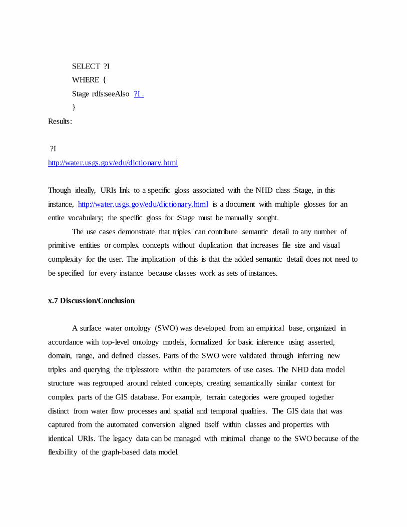
SELECT ?I
WHERE {
Stage rdfs:seeAlso ?I .
}
Results:
?I
http://water.usgs.gov/edu/dictionary.html
Though ideally, URIs link to a specific gloss associated with the NHD class :Stage, in this
instance, http://water.usgs.gov/edu/dictionary.html is a document with multiple glosses for an
entire vocabulary; the specific gloss for :Stage must be manually sought.
The use cases demonstrate that triples can contribute semantic detail to any number of
primitive entities or complex concepts without duplication that increases file size and visual
complexity for the user. The implication of this is that the added semantic detail does not need to
be specified for every instance because classes work as sets of instances.
x.7 Discussion/Conclusion
A surface water ontology (SWO) was developed from an empirical base, organized in
accordance with top-level ontology models, formalized for basic inference using asserted,
domain, range, and defined classes. Parts of the SWO were validated through inferring new
triples and querying the triplesstore within the parameters of use cases. The NHD data model
structure was regrouped around related concepts, creating semantically similar context for
complex parts of the GIS database. For example, terrain categories were grouped together
distinct from water flow processes and spatial and temporal qualities. The GIS data that was
captured from the automated conversion aligned itself within classes and properties with
identical URIs. The legacy data can be managed with minimal change to the SWO because of the
flexibility of the graph-based data model.
By developing the SWO, feature classification was no longer based on geometric
constraints of layer-based GIS, but on relations between concepts made more intuitive to the user
through natural language. For example, GIS data layers were organized by feature geometry,
which constrained water feature and flow modeling along Flowlines, modeled as linear features
in one layer, though water bodies, modeled as polygons, formed as a separate layer. A class of
objects called Artificial Paths was required to resolve the discrepancy between lines and polygon
disconnect in layer-based NHD. With the SWO, water flow is easily modeled along the surface
water network in a way that more closely resembles the real world because coordinate geometry
constraints are removed. Feature types, processes, and qualities were reorganized in semantic
technology along guidelines consistent with cognitive understanding of real world entities. The
conclusion of this study is that though the ontology requires further refinement, it demonstrates
the potential of semantic technology for advancing surface water data semantics.
References
Allemang, D. and Hendler, J. 2011. Semantic Web for the Working Ontologist, 2nd Edition.
Effective Modeling in RDFS and OWL. Burlington, MA: Morgan Kaufman.
Bennett, B. 2001. Application of supervaluation semantics to vaguely defined spatial concepts.
In D.R. Montello, ed., Spatial Information Theory: foundations of Geographic Information
Science: Proceedings of COSIT ’01, v. 2205 of LNCS, pp. 108-123, Morro Bay. Springer.
Brickley, D. and Guha, R.V. 2014. RDF Schema 1.1. W3C. http://www.w3.org/TR/rdf-schema/.
Cox, S.J.D. 2011. OWL representation of ISO 19156 (Observation model).
http://def.seegrid.csiro.au/isotc211/iso19156/2011/observation (accessed July 21, 2014).
Cyganiak, R., Wood, D., and Lanthaler, M. RDF 1.1 Concepts and Abstract Syntax. W3C.
http://www.w3.org/TR/rdf11-concepts/.

Dublin Core Metadata Initiative. 2012. DCMI Metadata Terms.
http://dublincore.org/documents/dcmi-terms/ (accessed August 28, 2014).
Duce, S. and Janowicz, K. 2010. Microtheories for Spatial Data Infrastrcutures – Accounting for
Diversity of Local Conceptualizations at a Global Level. In eds. S. I. Fabrikant, T.
Reichenbacher, M. J. van Kreveld, and C. Schlieder, 6th International Conference on Geographic
Information Science (GIScience 2010), volume 6292 Lecture Notes in Computer Science, pages
27-41. Springer.
EnvO. 2013. EnvO. http://environmentontology.org/ (accessed August 12, 2014).
Feng, C.-C. and Sorokine. A. 2014. Comparing English, Mandarin, and Russian Hydrographic
and Terrain Categories. International Journal of Geographic Information Science 28:1294-1315.
Feng, C-C., Bittner, T., and Flewelling, D. 2004. M. Modeling Surface Hydrology Concepts with
Endurance and Perdurance. In GIScience: Proceedings Lecture Notes in Computer Science, eds.
Egenhofer, M., Freksa, C., and Miller, H. J., 67-80.
Fox, P. and McGuinness, D.L. 2008. TWC Semantic Web Technology. at:
http://tw.rpi.edu/web/doc/TWC_SemanticWebMethodology (accessed Nov. 27, 2013).
Gangemi, A. and Presutti, V. 2010. Towards a pattern science for the semantic web. Semantic
Web 1: 61-68.
Hahmann, T., and Brodaric, B. 2012. The Void in Hydro Ontology. Frontiers in Artificial
Intelligence and Applications, 239: Formal Ontology in Information Systems. 45-58.
Hart, G. and Dolbear, C., 2012, Ordnance Survey Hudrology Ontology V2.0. Ordnance Survey.
http://www.ordnancesurvey.co.uk/oswebsite/ontology/Hydrology/v2.0/Hydrologyv2.0.mht
(accessed October 12, 2012).
Hitzler, P., Krötzsch, M., and Rudolph, S. 2010. Foundations of Semantic Web Technologies.
Boca Raton, FL: CRC Press.
ISO/IEC. 2007. Information technology – Common Logic (CL): a framework for a family of
logic-based languages. First edition 2007-10-01. Reference number ISO/IEC 24707:2007.
Geneva, Switzerland.
Knublauch, H. 2011. SPIN – SPARQL Syntax. W3C.
http://www.w3.org/Submission/2011/SUBM-spin-sparql-20110222/. (accessed August 26,
2014).
Lebo, T., Sahoo, S., and McGuinness, D. 2013. PROV-O: The PROV Ontology.
http://www.w3.org/TR/prov-o/ accessed July 21, 2014.
Mattli, D. NationalMap2rdf-new.py. Computer program. http://cegis.usgs.gov/ontology.html
(accessed August 12, 2014).
Neuendorf, K.A., 2002, The Content Analysis Guidebook. Thousand Oaks, CA Sage
Publications.
Ordnance Survey. 2008. Hydrology. Ordnance Survey. Written Communication [Original
document no longer available over the Internet, but copied and in possession of the author].
Patroumpas, K., Giannopoulos, G., and Athansiou, S. 2014. Towards GeoSpatial Semantic Data
Management: Strengths, Weaknesses, and Challenges Ahead. ACM-SIGSPATIAL 2014. Nov.
4-7, 2014, Dallas, Texas.
Pease, A. 2011. Ontology, A Practical Guide. Angwin, CA: Articulate Software Press.
Perry, M. and Herring, J., 2012, OGC GeoSPARQL – A Geographic Query Language for RDF
Data. Open Geospatial Consortium project document OGC 11-052r4, v. 1.0.

Princeton University. WordNet, A lexical database for English. Princeton University.
http://wordnet.princeton.edu/ (accessed January 21, 2014).
Santos, P. and Bennett, B. 2005. Supervaluation Semantics for an Inland Water Feature
Ontology. IJCAI-05; proceedings of the Nineteenth International Joint Conference on Artificial
Intelligence. Edinburgh, Scotland, July 30 – August 5, 2005. Morgan Kaufmann, San Francisco,
Calif. 564-569.
Sinha, G., Mark, D., Kolas, D., Varanka, D., Romero, B.E., Feng, C., Usery, E.L., Liebermann,
J., and Sorokine, A. 2014. An Ontology Design Pattern for Surface Water Features. GIScience
2014.
Smith, B., Corresp. Author. 2014. Basic Formal Ontology 2.0. Draft Specification and User’s
Guide. http://www.ifomis.org/bfo/ (accessed July 20, 2014).
Strahler, A. N. 1952. Hypsometric (area-altitude) analysis of erosional topology. Geological
Society of America Bulletin 63: 1117–1142.
SWEET Ontologies 2.2. 2013. realmHydroBody.owl. NASA.
http://sweet.jpl.nasa.gov/ontology/ (accessed November 27, 2013).
TopBraid Composer. 2014. Set domains and ranges. TopBraid Composer Maestro Edition, v.
3.6.1.v20120622-1546R. TopQuadrant.
U.S. Geological Survey. 2014a. Hydrography; National Hydrography Dataset, Watershed
Boundary Dataset. U.S. Geological Survey. http://nhd.usgs.gov/ (accessed December 18, 2013).
U.S. Geological Survey. 2014b. The National Map. U.S. Geological Survey.
http://nationalmap.gov/ (accessed December 18, 2013).
U.S. Geological Survey. 2014c. NHD User Guide. U.S. Geological Survey.
http://nhd.usgs.gov/userguide.html (accessed July 22, 2014).

Usery, E.L. 2014. Spatial Feature Classes. In The International Encyclopedia of Geography;
People, the Earth, Environment, and Technology, eds. D. Richardson, N. Castree, M.F.
Goodchild, A.L. Kobayashi, W. Liu, and R. Marston, xx-xx. John Wiley and Sons.
Varanka, D. 2014. Surface Water Ontology. U.S. Geological Survey.
http://cegis.usgs.gov/ontology.html (forthcoming).
Viers, W. GIS NHD Ontology. U.S.Geological Survey. http://cegis.usgs.gov/ontology.html
(accessed August 12, 2014).
W3C OWL Working Group. 2012. OWL 2 Web Ontology Language Document Overview
(Second Edition). http://www.w3.org/TR/owl2-overview/.
Wellen, C.C. and Sieber, R.E. 2013. Toward an inclusive semantic interoperability: the case of
Cree hydrographic features. International Journal of Geographical Information Science 27:168-
191.
Wiegers, K.E. 2003. Software Requirements. Redmond WA: Microsoft Press.