an ambitious relief model project - mountain cartography
TRANSCRIPT

6th ICA Mountain Cartography Workshop Mountain Mapping and Visualisation • 185
An Ambitious Relief Model Project
An Ambitious Relief Model ProjectA Combination of a Handmade, a Computer-Generated and a Profi led Relief Model
Stefan Räber, Lorenz HurniInstitute of Cartography, ETH Zurich, Switzerland
Abstract
Th e main topic of this paper is to explain the construction of a fi ve metre long and seventy centimetres wide relief model, scale 1:50,000, displaying a section of the Alps running from north to south. Th e fi nal relief model surface will be coloured according to the tectonic structure of the landscape, while on the sidewall a geologically coloured profi le will be visible. Th e production of the relief model combines workmanship with computer tech-niques. An intermediate piece of the model will consist of a pre-served handmade relief model by Jakob Oberholzer from 1911. Th e rest of the area will be carved in four diff erent parts by a milling machine. Th e geological painting will be accomplished manually by the geographer Toni Mair, who has extensive expe-rience in painting relief models. Th e complete model will be on display in a tower, where selected topics from the earth sciences will be explained via geological relief models. It is a part of the so-called future “FocusTerra” exhibition at ETH Zurich.
Introduction1.
Th e number of natural disasters has increased dramatically in recent years. Th e general public calls for information about the reasons leading to those catastrophes, and is concerned about future developments. Are natural hazards predictable, and will the population be alerted in good time? Experts in the fi eld of natural hazards are currently planning an exhi-bition at ETH Zurich called “FocusTerra”, which among others topics aims at demonstrating the detailed geological processes involved in natural disasters.
FocusTerra2.
FocusTerra is a new earth science research and informa-tion centre of the ETH Zurich, which will be opened on2nd April 2009. FocusTerra intends to present to a wide audience the most important, the most beautiful and the most recently discovered features of our planet earth. It does so by preparing and exhibiting visually appealing models, current experiments and spectacular objects.
FocusTerra site – patio with exhibition tower.Fig. 1:
An Ambitious Relief Model Project
186 • Mountain Mapping and Visualisation 6th ICA Mountain Cartography Workshop
FocusTerra is co-funded by the Federal Authorities of the Swiss Confederation. Additionally, the ETH Zurich foun-dation off ers interested patrons and sponsors diff erent ways in actively supporting the dialogue between humankind and earth. Located as centrally as possible, FocusTerra will be hosted in the historical main building of ETH Zurich. With FocusTerra a permanent exhibition is under construc-tion, which covers, along with temporary exhibitions or events, three fl oors, including a patio, where a fashionable tower marks the core of the exhibition (Fig. 1). FocusTerra is one of the sustaining elements within the “Kultur- und Bildungsmeile“ (cultural and educational passage) between the Museum of Fine Arts, and the area where ETH and University of Zurich are located.
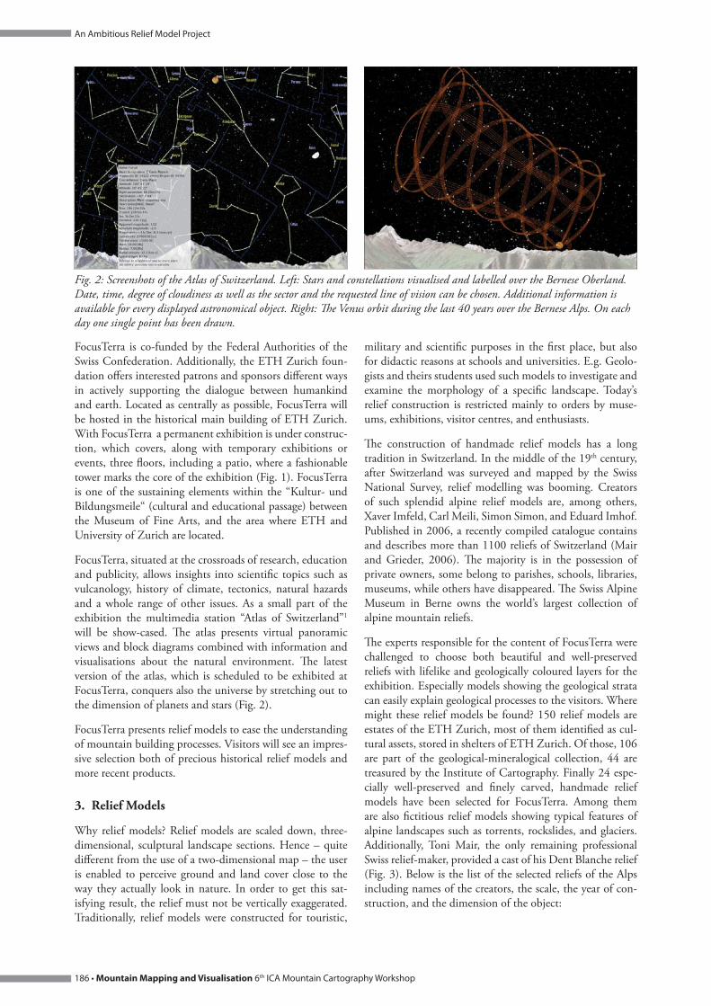
FocusTerra, situated at the crossroads of research, education and publicity, allows insights into scientifi c topics such as vulcanology, history of climate, tectonics, natural hazards and a whole range of other issues. As a small part of the exhibition the multimedia station “Atlas of Switzerland”1 will be show-cased. Th e atlas presents virtual panoramic views and block diagrams combined with information and visualisations about the natural environment. Th e latest version of the atlas, which is scheduled to be exhibited at FocusTerra, conquers also the universe by stretching out to the dimension of planets and stars (Fig. 2).
FocusTerra presents relief models to ease the understanding of mountain building processes. Visitors will see an impres-sive selection both of precious historical relief models and more recent products.
Relief Models3.
Why relief models? Relief models are scaled down, three-dimensional, sculptural landscape sections. Hence – quite diff erent from the use of a two-dimensional map – the user is enabled to perceive ground and land cover close to the way they actually look in nature. In order to get this sat-isfying result, the relief must not be vertically exaggerated. Traditionally, relief models were constructed for touristic,
military and scientifi c purposes in the fi rst place, but also for didactic reasons at schools and universities. E.g. Geolo-gists and theirs students used such models to investigate and examine the morphology of a specifi c landscape. Today’s relief construction is restricted mainly to orders by muse-ums, exhibitions, visitor centres, and enthusiasts.
Th e construction of handmade relief models has a long tradition in Switzerland. In the middle of the 19th century, after Switzerland was surveyed and mapped by the Swiss National Survey, relief modelling was booming. Creators of such splendid alpine relief models are, among others, Xaver Imfeld, Carl Meili, Simon Simon, and Eduard Imhof. Published in 2006, a recently compiled catalogue contains and describes more than 1100 reliefs of Switzerland (Mair and Grieder, 2006). Th e majority is in the possession of private owners, some belong to parishes, schools, libraries, museums, while others have disappeared. Th e Swiss Alpine Museum in Berne owns the world’s largest collection of alpine mountain reliefs.
Th e experts responsible for the content of FocusTerra were challenged to choose both beautiful and well-preserved reliefs with lifelike and geologically coloured layers for the exhibition. Especially models showing the geological strata can easily explain geological processes to the visitors. Where might these relief models be found? 150 relief models are estates of the ETH Zurich, most of them identifi ed as cul-tural assets, stored in shelters of ETH Zurich. Of those, 106 are part of the geological-mineralogical collection, 44 are treasured by the Institute of Cartography. Finally 24 espe-cially well-preserved and fi nely carved, handmade relief models have been selected for FocusTerra. Among them are also fi ctitious relief models showing typical features of alpine landscapes such as torrents, rockslides, and glaciers. Additionally, Toni Mair, the only remaining professional Swiss relief-maker, provided a cast of his Dent Blanche relief (Fig. 3). Below is the list of the selected reliefs of the Alps including names of the creators, the scale, the year of con-struction, and the dimension of the object:
Screenshots of the Atlas of Switzerland. Left: Stars and constellations visualised and labelled over the Bernese Oberland. Fig. 2: Date, time, degree of cloudiness as well as the sector and the requested line of vision can be chosen. Additional information is available for every displayed astronomical object. Right: Th e Venus orbit during the last 40 years over the Bernese Alps. On each day one single point has been drawn.

6th ICA Mountain Cartography Workshop Mountain Mapping and Visualisation • 187
An Ambitious Relief Model Project
Object Scale Author Year Dim. [cm]
Switzerland 100,000 Perron C.E. 1896 – 1900 350 x 240
Dents du Midi 16,666 Graff J., Hausamann A., Vaucher J. 1896 75 x 75
Matterhorn (Fig. 3) 5,000 Imfeld X. 1896 74 x 68
Dent Blanche (Fig. 3) 5,000 Mair T. 2005 90 x 70
Titlis / Sustenhorn 25,000 Imfeld X. 1889 – 1890 139 x 62
Urnersee 25,000 Imfeld X.; col.: Heim A. 1877 – 1890 105 x 96
Pilatus 10,000 Imfeld X., Heim A., Meili C., Hürlimann H. 1908 – 1913 125.5 x 84
Rigi 25,000 Imfeld X.; col.: Heim A., Buxtorf A., Baumberger E. 1908 80 x 55
Mythen 5,000 Reichlin J., Heim A.; col.: Imhof E. 1932 37 x 63
Fluhberg 5,000 Oberholzer E. 1952 – 1953 96 x 58
Mürtschenstock (Fig. 3) 10,000 Imhof E. 1920 – 1922 45 x 30
Lenzerheide 25,000 Meili C.; col.: Geiser M. 51 x 87
Luganersee 25,000 Becker F.; col.: Heim A. 1896 70 x 100
Säntis (profi le series) 25,000 Escher A., Heim A.
Säntis 25,000 Meili C. 1904 97 x 51
Säntis 5,000 Meili C.; instructions: Heim A. 1899 – 1903
Peak Säntis (Fig. 3) 2,500 Meili C.; col.: Heim A. 1899 85 x 55
"Historic and thematic reliefs"
Jura (Canton of Basel) 60,000 Gressly A. 1860 62 x 46
Rockslide of Elm 4,000 Heim A. 1900 46 x 71
Glacier 18,000 Heim A.
Torrent 18,000 Heim A.
Alpi Apuane 50,000 Sacco F.
Volcano island 10,000 Heim A.
Workfl ow series of relief models 20,000 Mair T. 2007
Glarus' Alps 50,000 Oberholzer J.; col.: Geiser M. 1911 70.5 x 95
(From upper left to bottom right): Models of Matterhorn – south face; Säntis – peak region; Mürtschenstock – seen from Fig. 3: the North; Dent Blanche – peak region seen from the Southeast.
An Ambitious Relief Model Project
188 • Mountain Mapping and Visualisation 6th ICA Mountain Cartography Workshop
New Relief Model of the Alps4.
As an additional attraction FocusTerra intends to construct a new, large-area relief. Because of the initial fi nancial out-lay, the limited time for preparation and a lack of profes-sional relief model artists, new techniques were claimed. Th e result will be a combination of a hand-crafted, a computer-generated and a profi led relief model. So far, this modern approach has hardly ever been tested to automatically carve relief models of this size.
Th e goal of this project is to give the visitors an up-to-date topographical and geological overview about the Alps, their structure and tectonic developments. To fulfi l this aim, the most suitable and most interesting section within the north south alpine profi le has been chosen. Th e fi nal dimension of the construction results in a fi ve meter long and seventy cen-timetres wide relief model, scale 1:50,000, showing parts of the Alps from Lake Constance in the North to the Po Valley in the South. Th e model needs to be arranged according to the complex, ankle-dominated interior (Fig. 8). Th e fi nal relief model will be coloured according to the tectonic fea-tures of the original landscape, while the sidewall will reveal a geologically coloured profi le.
Th is fascinating landscape contains a unique, impressively shaped mountain environment, the so-called “Glarus over-thrust”.
Th e Glarus Overthrust5.
Th e Glarus overthurst is located along the borders of three cantons – Glarus, Grisons, and St.Gallen. It is a remark-ably spectacular area of more than 300 square kilometres, covering the territory of 19 communities. Th is geological phenomenon starts rising in the valley of the Vorderrhein until it reaches a height of more than 3000 metres. After this peak, the rocky formation sinks towards sea level before it again gains altitude just at the northern fringe of the Alps. 250-300 million years old rock material drifts over younger sedimentary rock which is a approx. 50 million years old. [Th e currently prevailing view is that the Helvetic nappes at
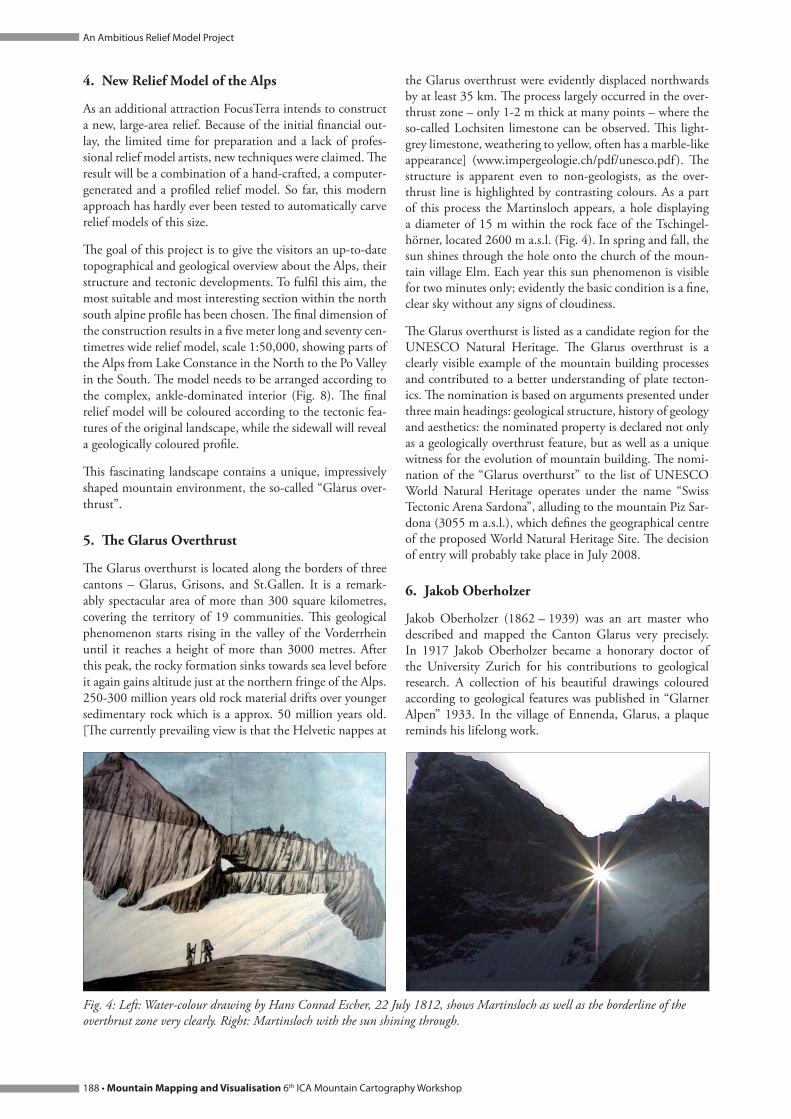
the Glarus overthrust were evidently displaced northwards by at least 35 km. Th e process largely occurred in the over-thrust zone – only 1-2 m thick at many points – where the so-called Lochsiten limestone can be observed. Th is light-grey limestone, weathering to yellow, often has a marble-like appearance] (www.impergeologie.ch/pdf/unesco.pdf ). Th e structure is apparent even to non-geologists, as the over-thrust line is highlighted by contrasting colours. As a part of this process the Martinsloch appears, a hole displaying a diameter of 15 m within the rock face of the Tschingel-hörner, located 2600 m a.s.l. (Fig. 4). In spring and fall, the sun shines through the hole onto the church of the moun-tain village Elm. Each year this sun phenomenon is visible for two minutes only; evidently the basic condition is a fi ne, clear sky without any signs of cloudiness.
Th e Glarus overthurst is listed as a candidate region for the UNESCO Natural Heritage. Th e Glarus overthrust is a clearly visible example of the mountain building processes and contributed to a better understanding of plate tecton-ics. Th e nomination is based on arguments presented under three main headings: geological structure, history of geology and aesthetics: the nominated property is declared not only as a geologically overthrust feature, but as well as a unique witness for the evolution of mountain building. Th e nomi-nation of the “Glarus overthurst” to the list of UNESCO World Natural Heritage operates under the name “Swiss Tectonic Arena Sardona”, alluding to the mountain Piz Sar-dona (3055 m a.s.l.), which defi nes the geographical centre of the proposed World Natural Heritage Site. Th e decision of entry will probably take place in July 2008.
Jakob Oberholzer6.
Jakob Oberholzer (1862 – 1939) was an art master who described and mapped the Canton Glarus very precisely. In 1917 Jakob Oberholzer became a honorary doctor of the University Zurich for his contributions to geological research. A collection of his beautiful drawings coloured according to geological features was published in “Glarner Alpen” 1933. In the village of Ennenda, Glarus, a plaque reminds his lifelong work.
Left: Water-colour drawing by Hans Conrad Escher, 22 July 1812, shows Martinsloch as well as the borderline of the Fig. 4: overthrust zone very clearly. Right: Martinsloch with the sun shining through.

6th ICA Mountain Cartography Workshop Mountain Mapping and Visualisation • 189
An Ambitious Relief Model Project
Th e upper red layer is sliding over younger material. Th e drawing shows the Glarus overthrust nicely, and also – in the Fig. 5: middle – the old landslide shaded in grey by Jakob Oberholzer, 1914.
Relief model made by Jakob Oberholzer, 1911, geologically coloured by Max R. Geiser and the legend.Fig. 6: (Photo composition Stefan Räber).

An Ambitious Relief Model Project
190 • Mountain Mapping and Visualisation 6th ICA Mountain Cartography Workshop
is a relief which provides suffi cient quality for the project in question. On top of this, production period and production costs stay within a reasonable range.
Raplab2, ETH Zurich provides a three-axis CNC milling machine with a work space of 2.4 by 1.5 m. Th is machine can create 3D surfaces with a vertical diff erence of up to 25 cm, which is a satisfactory value for the purposes of the project. Th e machine uses a subtractive process to carve three-dimensional objects out of non-metallic and non-ceramic material.
In tests, diff erent types of wooden material and soft pack-ing material like styrofoam, foam-plastic, medium-density fi berboard, or synthetics have been evaluated. Crucial for the choice of the best material was the degree of hardness. As for the relief of the Alps the choice fell on the material “Ureol” – a quite compact material with an adverse time management: milling takes much more time than with softer materials.
Th e basic requirements for a accurately milled relief are the input data. Th ose are to be collected via digital elevation models (DEMs) of the highest possible precision. Th e Alp relief displaying Swiss terrain including parts of the Italian border area is based on the DHM25, produced by swiss-topo3. Th is DEM was derived from the Swiss National Map 1:25,000 and refl ects its accuracy. Since some of the south-ern parts lie outside the area covered by DHM25, an addi-tional DEM is necessary.
Milling tests based on the DHM25 in combination with to diff erent elevation models lead to the conclusion that the
Extension of the relief model: in red the Oberholzer relief, in black the automatically carved section.Fig. 8:
Jakob Oberholzer (1862Fig. 7: – 1939).
His graphic skills and his ability of detailed observation play a crucial role not only in designing geological maps, but also in creating various reliefs. 1911 Jakob Oberholzer built a relief model in the scale 1:50,000 of the mountainous Can-ton Glarus, which includes the Glarus overthrust (Fig. 6). Like most professional handmade models, the Oberholzer model is made of plaster. Th e model has been geologically coloured by Max R. Geiser, Zurich. Th e object measures 112 by 88 cm. Th e Glarus relief is a lifelike reproduction in pristine condition. It is for this reason that the handmade Oberholzer model will be used as an intermediate piece for the above described relief of FocusTerra. But who is going to create the other part of the relief model? And how?
CNC Milling Machine7.
A CNC (Computer numerical control) milling machine is producing the fi nal part of the sculptural work. Why a CNC milling machine? Th e milling process is quite simple and does not require any manual skills which are normally essential for the production of landscape models. Th e result

6th ICA Mountain Cartography Workshop Mountain Mapping and Visualisation • 191
An Ambitious Relief Model Project
open source elevation data of Jonathan de Ferranti allow for the best visual results. For his DEM, which he reworks manually, Jonathan de Ferranti uses besides the SRTM data also other freely accessible data. Th ose data are off ered by de Ferranti in the SRTM-format. Th ey might not be as reliable as a authorised or commercial DEM, but they are available across national borders. Ferranti’s DEM needs to be pro-jected onto the Swiss national grid in order to be compatible with the data of the DHM25.
Where the two DEMs collide unsightly artifacts emerge. A manual adjustment eliminates the most substantial errors. Additional enhancement of DEM-quality can be achieved by masking the lakes in the DEM. In doing so, the water surfaces appear even. For this purpose the VECTOR25 data set of swisstopo served as a source. Other lacks of quality which can be hardly omitted become visible especially in steep terrain.
Due to the large dimensions and the angulated footprint of the relief (Fig. 8), the model is going to be milled in four separate blocks.
Besides the input data the milling process itself defi nes the quality of the relief. Th e actual milling is subdivided into three stages:
1. Horizontal Roughing: Removing of the Ureol in terrace-like levels with a milling bit equipped with a ball nose dia-meter of 12 mm.
2. Semi-fi nishing: Smoothing the terraces, again using the milling bit as described in stage 1.
3. Finishing: Two milling direction each adjusted to a 45 / -45degree angle, by using a milling bit with a ball nose diam-eter of only 3 mm.
Th e milling phases described above take several hours for each block of the model. A supervising person is present during the complete milling process. Th e manual painting with gouache colours will be accomplished by relief artist Toni Mair (Fig. 10), who has extensive experience in paint-ing relief models. Finally, the newly carved and painted pieces will be assembled and fi tted to the nearly 100 years older Oberholzer relief model.
Once completed, the relief will be positioned onto a pedes-tal of 120 cm in height and embedded into a wall. Painted on the pedestal is the interior of the earth with its tectonic layers (down to a depth of approx. 60 km). Th e back wall will also get painted with the vertical prolongation of the excavated rocky material. Illumination comes from one direction which the relief obtains a natural shading. Th e entire installation might be admired without an interferring showcase or glass wall between relief and visitor.
Conclusion8.
Th e quality of computer-generated reliefs depends on one hand on the material, on the other hand on the quality of the input data. Th e end result may as well be infl uenced by the choice of milling bits and the direction and speed of mill-ing. CNC milling machines would be capable of generating overhanging portions of rock faces, thanks to their adjust-able milling bits. But currently this is not very useful, since today’s DEMs do not contain such information. Moreover, milled precipices appear as too schematic (Fig. 11).
Th e initiators are quite satisfi ed by the result, which might not entirely convince a trained relief maker in all its parts. Nevertheless the quality of the relief can be called satisfying regarding the purposes described above. Th e fact, that ana-logue and digital methods might be compared for the fi rst time ever in one model, deserves to be underlined: Th is is a true novelty!
Outlook9.
It is the author's fi rm belief that in the future relief con-structors might produce high quality reliefs with the sup-port of CNC milling machines. Th ose products will not have to fear competition with the manually built, artful pieces of relief artists such as Imfeld or Imhof. In his view, the relief making process ideally starts with an automatically carved negative form of the future relief model. For this step aff ordable DEMs of high quality need to be available. A plaster mold allows to work according to traditional carv-ing methods by using potter tools. Hence the time and cost consuming phases of building a step model made of wood could be skipped, i.e. the transformation of contour lines to wallboard plates, the sawing of the plates by following the contour lines, and the assembling of the plates to a stack to obtain a rough negative terrain model. In order to cover up shortcomings of the milling, especially in the case of such complexe landscapes as alpine regions with rock, it is still indispensable to make adjustments manually. Only then it will be possible to create lifelike portrays of landscape sur-faces. Th is means that the skills of a professional relief artist are still needed to bring the relief model to perfection.
1 Th e “Atlas of Switzerland” is a joint project of the ETH Zurich’s Insti-tute of Cartography, the ETH Board, the Swiss Federal Statistical Offi ce (SFSO) and the Swiss Federal Offi ce of Topography (swisstopo).www.atlasofswitzerland.ch
2 “Raplab” stands for Rapid Architectural Prototyping Laboratory, a model laboratory of ETH Zurich.www.raplab.arch.ethz.ch
3 “swisstopo” is the competence centre of the Swiss Confederation responsible for geographical reference data and all products derived from them. Th e Federal Offi ce of Topography (swisstopo) is located in Wabernnear Berne.www.swisstopo.admin.ch

An Ambitious Relief Model Project
192 • Mountain Mapping and Visualisation 6th ICA Mountain Cartography Workshop
Handmade, more vivid model (left) vs. automatic, more schematic model (right). Both photos show the Eiger north face.Fig. 11:
Left: Test by a CNC milling machine, Raplab ETH Zurich. Upper right: Selected milling bit with ball nose.Fig. 9: Bottom right: milled surface after horizontal roughing.
Toni Mair, relief artist, with a CNC milled prototype (left, see circle) short before adjustment on coloured handmade Fig. 10: Oberholzer relief (right) (photos Stefan Räber, 2008).

6th ICA Mountain Cartography Workshop Mountain Mapping and Visualisation • 193
An Ambitious Relief Model Project
References
Caminada, P. (2003): Pioniere der Alpentopografi e. As Verlag, Zürich, 240 p.
Cavelti, M. et al. (2006): Xaver Imfeld – Meister der Alpentopografi e. von Ah Druck AG, Sarnen, 192 p.
Hell, G. and Semann, M. (1999): Kartographischer Reliefbau: Heutige Möglichkeiten mit Rapid Prototyping Verfahren. In: Kartographische Nachrichten, 49. Jahrgang, Heft 5, Bonn, 185–192.
Imhof, E. (1981): Bildhauer der Berge. Ein Bericht über alpine Gebirgsmodelle in der Schweiz. Wissenschaftliche Mittei-lungen des Schweizerischen Alpinen Museums Bern Nr.11, Separatdruck aus „Die Alpen“, 57. Jahrgang, 3. Quartal, Bern, 66 p.
Mair, T. and Grieder, S. (2006) Das Landschaftsrelief, Symbiose von Wissenschaft und Kunsthandwerk, mit Schweizer Reliefkatalog. hier + jetzt, Baden, 176 p.
Oberholzer, J. (1920): Geologische Karte der Alpen zwischen Linthgebiet und Rhein, 1:50,000. Schweiz. Geol. Komm. Spez. Karte, Nr. 63.
Oberholzer, J. (1933): Geologie der Glarneralpen, Beiträge zur geologischen Karte der Schweiz. Geologische Kommission der Schweiz. Naturforschenden Gesellschaft.
Oberholzer, J. (1942): Geologische Karte des Kantons Glarus, 1:25,000. Schweiz. Geol. Komm. Spez. Karte, Nr. 117.
Räber, St. (2006): Handmade Relief Models. Proceedings of the 5th ICA Mountain Cartography Workshop, Bohinj, Slovenia, 222–227.
Räber, St. (2006): Le relief du Bietschhorn – Restauration d’une montagne. Les Alpes 11/2006, Editions du CAS, Berne, 36–37.
Trümpy, R. (1991): Th e Glarus Nappes: A Controversy of a Century Ago. In: Mckenzie, J. & Müller, D. (eds.): Contro-versies in Modern Geology. Academic Press, London, 385–404.
Trümpy, R. and Lemoine, M. (1998): Marcel Bertrand (1847–1907), Les nappes de charriage et le cycle orogénique. C.R. Acad.Sci. Paris, Sciences de la terre et des planètes 237, 211–224.
Websites (verifi ed February 2008)
www.terrainmodels.comwww.reliefshading.comwww.raplab.arch.ethz.chwww.alpinesmuseum.ch
Digital Elevation Models:www.swisstopo.admin.ch/internet/swisstopo/en/home/products/height/dhm25.htmlwww.viewfi nderpanoramas.org/dem3.html
Natural Heritage:whc.unesco.orgwww.geopark.chwww.impergeologie.chwww.earthsci.unibe.ch/geologie/unesco_glarner_hauptueb.htmwww.bafu.admin.ch/aktuell/medieninformation/00004/index.html?lang=en&msg-id=17666