an ablatio n r ate for lake fr yxell, victoria land, antar ... · an ablatio n r ate for lake fr...
TRANSCRIPT

AN AB L ATI O N R ATE FO R LAKE FR YXELL, VICTORIA LAND, ANTA R CTICA
By R . A. HENDERSON, W. M. PREBBLE, R. A. Ho ARE, K. B. P OPPLEWELL,
D . A. HousE and A. T . WILSON*
(Victoria University of W ellington, Wellington, New Zealand)
ABSTRACT. The average yearl y net ablation rate on permanently ice-covered Lake Fryxell , Victoria Land , Antarctica, is 30 to 40 cm. This figure was calculated by a novel method utilizing a record of ablation wh ich is incorporated in the ice cover of the lake. These values are higher than those m easured on Ross Island 80 km. to the east; the difference in ablation rates for the two areas is attributed to the prevalence ofkatabatic winds in the climate of Taylor Valley. The Lake Fryxell ablation figure is app lied to nearby Canada and Commonwealth Glaciers in the calculation of their ice budgets.
R EsuME. La vitesse d'ablation du Lake Fryxell, Victoria Land, Antarctiqlle. La valeur moyenne annuelle de I'ablation nette de la glace permanente qui recouvre le Lake Fryxell , Victoria Land, Antarctique, est d e 30 a 40 cm. Cette valeur a ete calculee par une nouvelle methode utilisant I'enregistrement de l'ablation qui est incorpore dans la g lace du lac. Ces valeurs sont plus fortes que celles mesurees sur R oss Island 80 km a I'est; la difference de va leurs d'ablation pour les deux regions est attribuee a la pred ominance des vents catabatiques dans le climat de Taylor Valley. La va leur de l'ablation du Lake Fryxell est appliquee aux proches du Canada et Commonwealth Glaciers pour le calcul de leur bilan.
ZUSAMMENFASSUNG. Eisablation am Lake F~yxell , Victoria Land, Antarktika. Die mittle re jahrliche Nettoa blation auf dem standig eisbedeckten Lake Fryxell in V ictoria Land, Antarktika, b etragt 30 bis 40 cm. Diese Zahl wurde mit einer neuartigen M ethode bestimmt, die ein in die Eisdecke d es Sees ei ngeiassenes Ablationsmessgerat benutzt. Sie ist h6her als die Werte, die 80 km weiter 6s tlich auf der Ross Island gemessen wurden. D el' Un terschied in der Ablationsgeschwindigkeit zwischen den beiden Gebie ten wird a uf das Vorherrschen katabatischer Winde im K lima d es Taylor Va lley zuruckgefuhrt. D er Ablationswert des Lake Fryxell w ird zur Berechnung des Eishaushaltes d er benachbarten Canada und Commonwealth Glaciers verwend et.
I NTRODUCTION
Lake Fryxell (lat. 77° 37' S., long. 163° 7' E. ) is a permanen tly ice-covet"ed lake situated in lower Taylor Valley at an a ltitude of 22 m. No information is avai lable for the climate of the area, but on Ross I sla nd 80 km. to the east the m ean a nnual temperature is approximately - 17°C. with a range of approximately 45°C. (D avid and Priestley, 1914; Flowers, 1958), and the total so lar energy of wave-length > 3 fL fa lling is 93,000 cal. /cm!yr. (Thompson and Macdonald , 196 I ) .
The physiographic position of Taylor Valley modifies the climate; westerly winds descending from the polar plateau are channelled by the valley, and ad iabatic heating and reduction in relative humidity result. Sections of ice core obtained by drilling through the lake ice-cover were stood vertically on its surface; periodic inspection of the cross-sectional shape of these cores showed that maximum ablation occurred during periods of westerly wind .
In November 1963 the eighth Victoria University Expedition carried out a limnological investigation of Lake Fryxell . A series of ice platforms were observed, and the measured heights between successive ice platforms were interpreted to give a measure of ablation of the lake ice .
FORMATION AND SIGNIFICANCE OF I CE P LATFORMS
The lake ice-cover, which varies in thickness from 3.8 to 4' 5 m. ) is being continually replaced by accretion of ice at the ice- water interface and ablation from the surface . During summer, absorption of solar energy causes the formation of water-fi ll ed inte rstices within the ice column. In late summer the ice column becomes permeable by interconnection of the interstices and a water table appears at depths varying between 45 and 56 cm. below the m ean surface of the ice. Interstices above the water table are then drained.
• Scien tific leader, Victoria Un iversity of W ell ington Antarctic Exped ition No. 8.
129
JO U RNAL OF GLAC I OLOGY
Ice Platt am tl)
le! wll l1 .w fd led l'll."~-- lcePla tt ()lll I I I _Rlst duelo IA\ and (Q )
__ --f-.,(II!I_ .. I-_...::'"::::'''.:::st'.:::.ces~ ___ _+-~r_.p..::-=--R::::''::::''=-"' =-to ...::IA '::::. '.:..B '.'--' .:..C,.'----_~-~~---- WATER TABLE
lee with .,.aler
filled mterstlces
~ . . ,
; ,: : . , " ; ;,.:
LATE SUld.v.ER WINTER
FOIl1'.allooolne" l( t
Inlnlelst lces IAI,
FOlllla\ roo oIll!w Ice i lbm (91.
LATE SUMME R
Polenllal Ict Platlotm f2I
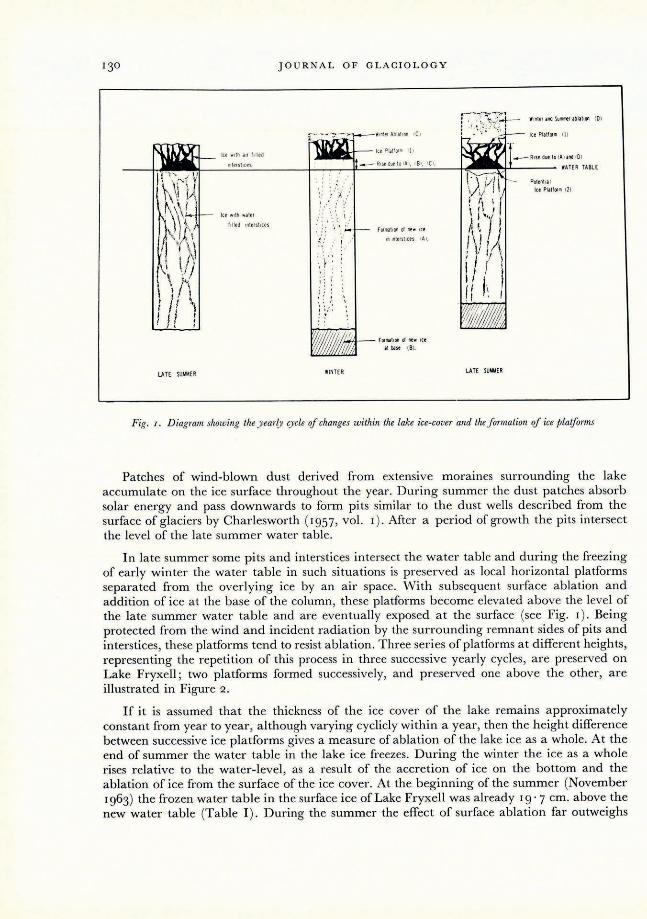
Fig. I. Diagram showing the y early c),cle of changes within the lake ice-cover and the formation of ice platforms
Patches of wind-blown dust derived from extensive moraines surrounding the lake accumulate on the ice surface throughout the year. During summer the dust patches absorb solar energy and pass downwards to form pits similar to the dust wells described from the surface of glaciers by Charlesworth (1957, vol. I). After a period of growth the pits intersect the level of the late summer wa ter table.
In late summer some pits and interstices intersect the water table and during the freezing of early winter the water table in such situations is preserved as local horizontal pla tforms separated from the overlying ice by an air space. With subsequent surface ablation and addition of ice at the base of the column, these platforms become elevated above the level of the late summer water table and are eventually exposed at the surface (see Fig. I). Being protected from the wind and incident radiation by the surrounding remnant sides of pits and interstices, these platforms tend to resist ablation. Three series of platforms at different heights, representing the repetition of this process in three successive yearly cycles, are preserved on Lake Fryxell; two platforms formed successively, and preserved one above the other, are illustrated in Figure 2 .
If it is assumed that the thickness of the ice cover of the lake remains approximately constant from year to year, although varying cyclicly within a year, then the h eight difference between successive ice platforms gives a m easure of ablation of the lake ice as a whole. At the end of summer the water table in the lake ice freezes. During the winter the ice as a whole rises relative to the water-level, as a result of the accretion of ice on the bottom and the ablation of ice from the surface of the ice cover. At the beginning of the summer (November 1963) the frozen water table in the surface ice of Lake Fryxell was already 19· 7 cm. above the new water table (Table I ) . During the summer the effect of surface ablation far outweighs

ABLATION RATE FOR LAKE FRYXELL , VICTORIA LAND 131
Fig. 2 . Two slIccessive ice platforms preserved one above the other. The ta/)e measure rests on a /jlatform of clear ice formed ill
1963; the notebook and ice-axe rest on an ice platform formed in [962
bottom melting, so that from the winter of 1962 to the winter of 1963 a total rise of 40' 7 cm. had occurred. This total uplift equals the thickness of ice ablated from the surface, if it is assumed that the ice had the same thickness at the start of each winter. The assumed constancy of thickness is supported by the regularity of height differences between the three successive ice platforms and by a measurement of ice thickness in 1961- 62 (Angino and others, 1962), compared with that measured in November 1963. Measured heights of the 1963 ice platforms above the water table and the height differences between the 1963, 1962 and 1961 ice platforms are given in Table 1.
TABLE I
Number of observations
H eight of 1963 platform above water table 20
Height of 1962 platform above that of 1963 30 (net ablation for year 1962- 63)
Height of 1961 platform above that for 1962 2 (net ablation for year 1961 - 62)
Mean value Standard deviation of measurements of measurements
cm. cm.
19 ' 7 2·1
40 '7 3')
31 ·0 2'0
JO U RNAL OF GLACIOLOGY
CONCLUSIONS
The results yield a m ean net a blation figure of 40' 7 cm . of ice for the year-long cycle terminating with the winter freeze of 1963. The m ean value for the previous cycle was 3 I cm. of ice . Since no precipitation figures are available fo r this area, gross ablation cannot be calculated, but net ablation figures are more useful for calculating glacier ice budgets. These figures are considerably higher than those given for n et ablation at similar altitudes on Ross Island 80 km. to the east (David and Priestley, 19 I 4) . Estimates based on ablation m easurem ents for most of 1903 and 1908 are given as 15' 2 a nd 17.8 cm. , respectively . The difference between ablation values for opposing sides of McMurdo Sound is attributed to the prevalence of katabatic winds in T aylor Valley.
ApPLICATION TO THE I CE B UDGETS OF CANADA AND COMMONWEALTH GLACIERS
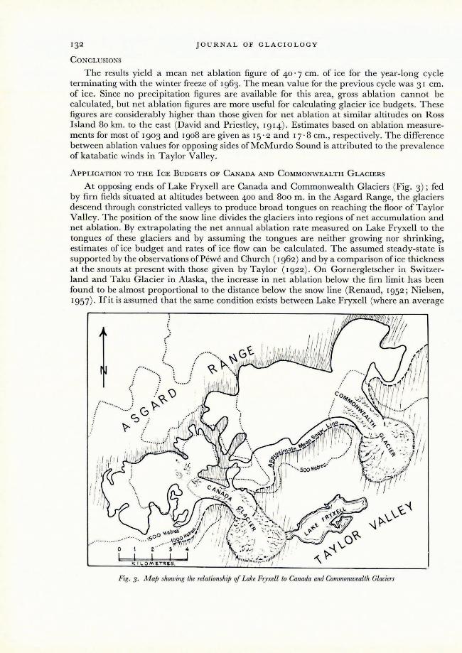
At opposing ends of Lake Fryxell are Canada and Commonwealth Glaciers (Fig. 3) ; fed by firn fields situated at altitudes between 400 and 800 m. in the Asgard Range, the glaciers descend through constricted valleys to produce broad tongues on reaching the floo r of T aylor Valley. The position of the snow line divides the glaciers into regions of net accumulation and net ablation. By extrapolating the net annual ablation rate measured on Lake Fryxell to the tongues of these glaciers and by assuming the tongues are neither growing nor shrinking, estimates of ice budge t and rates of ice flow can be calculated. The assumed steady-state is supported by the observations of Pewe and Church (1962) and by a comparison of ice thickness at the snouts at present with those given by Taylor (1922). On Gornergletscher in Switzerland and Taku Glacier in Alaska, the increase in ne t ablation below the firn limit has been found to be almost proportional to the distance below the snow line (Renaud, 1952 ; Nielsen, 1957) . Hit is assumed that the same condition exists between Lake Fryxell (where a n average
Fig. 3. M ap showing the relationship of Lake Fryxell to Canada and Commonwealth Glaciers

ABLATION RAT E F OR LAKE FR YXELL , V I CTOR IA LAND 133
fi gure for net ablation is 36 cm. ) and lhe snow line (where net ablation is zero), then net ablation on the snouts of Canada and Commonwealth Glaciers can be calculated by m easuring the areas of the tongues between the contours at 50 m . intervals and using the interpolated ablation figures for a ltitudes interm ediate between those of the contours.
I CE BALANCE FOR COMMONWEALTH GLACIER
If the nevi of the glacier is d efined as the a rea above the snow line and the tongue as that below, then the neve covers 46.2 km! and the tongue 7·7 km. '. 0.0015 km .> of ice ablate annually from the snout, so to maintain the glacie r at its present size the average net ice accumulation in its neve is 3·3 cm. ann ually. The narrowest part of the valley through which the ice d escends is I . 15 km. wide; assuming that the thickness of the g lacier in this position is 60 m., the flow rate is approximately 2 I m. /yr.
I CE BALANCE FOR CANADA GLACIER
The area of the glacier above the snow line is 23.6 km. \ while that below has a n area of 6·6km.'. 0·00 12 km.> of ice ab late annua lly from the snout; to m a in tain the glacier at its p resent size, the annual average net ice accumulation in the neve is 5· I cm. The most constricted part of the valley through which the glacier descends is I . 15 km. wide; assuming that the thickness of the glacier in this position is 60 m ., the flow rate is approximately 17 m. /yr.
The /leVe of Canad a Glacier lies mainly above the 1,000 m. contour, while that of Commonwealth Glacier is m a inly below (Fig. 3) . This height difference explains the higher precipitation in the firn fields of Canada Glacier compared with those of Commonwealth Glacier.
It is appreciated that the values given for ablation , accumulation or ice fl ow of the glaciers a re not necessarily exact. The purpose of the calculations is to provide es timates for a pproximate values for this type of alpine g lacier, so common in the ice-free areas of Victoria Land, in the absence of a ny field measurements.
ACKNOWLEDGEMENTS
Financial assistance for this research was provided by the New Zealand University Grants Committee and the Victoria University of Wellington R esearch Committee. T hanks are a lso due to the U.S. Navy for transport to a nd in the field , and to the Antarctic R esearch Division of the New Zealand D .S. I.R. for its help and hospi ta lity.
AIS. received 13 April 1965
REF E RE NCES
Angino, E. E. , and others. 1962. Chem ical strat ificat ion in Lake F ryxe1 l, Victoria Land, Antarct ica, b y E. E. A ngino, K. B. Arm itage and J. C. Tash. Science, Vo!. 138, No. 3536, p. 34- 36.
Charlesworth , J. K. 1957. The 0taterna~y era, with s/Jecial reference to its glaciation. London , Edward Arnold . 2 vols. David, T. W. E., and Pries tl ey, R. E. 1914. Glaciolog)" jJh)'siography, stratigraphy, alld tectonic geology q! south Victoria
L and. London , William Heinemann. (R eports on the Scientifi c I nvestigations of the British Antarct ic Expedition, 1907- 09. Geology, Vo!. I. )
Flowers, E . C. 1958. Weather at US- IG Y stat ions during 1957 . Transactions. American GeojJh)'sical Union, Vo!. 39, No. 5, p. 997- 1001; IGY Bulietin (Washington, D.C.), No. 15, p . 3- 7.
Nielsen , L. E. 1957. Preli mi nary study on the regimen and movement of the Taku G lac ier , Alaska. Bulletin oJ the Geological Socie(}' DJ America, Vo!. 68, No. 2, p. 171 - 80.
Pewe, T. L., and Church , P . E . 1962. G lacie r regimen in Antarct ica as reAected by g lacier-margin Auctuation in historic time with specia l reference to MCNlurdo Sound. Union Geodesique et Geophysique I nternationale. Association Internationale d' Hydrologie Scienti/ique. Commission des Neiges et Glaces. Colioque d'Obergurgl, 10- 9- I 8- 9 I962, p. 295- 305.
R enaud, A. 1952. Observa tions on the surface movement and ablation of the Gorner glacier (Switzerland) . Journal oJGlaciolog)' , Vo!. 2, No. 11 , p. 54- 57.
Taylor, T. G . 1922 . The physiography oJthe lvlcMurdo Sound and Granite H arbour region. L ondon, Harrison a nd Sons. (British Antarctic (Terra Nova) Expedi tion, 19 10- 191 3.)
Thompson, D. C., and Macdonald, W . .J . P . 196 1. M eteorology. Scott Base. Bulletin DJ the New Zealand D epartment DJ Scientific and Industrial R esearch, No. 140, p. 37- 56.