american promotional road mapping in the twentieth century
TRANSCRIPT
American Promotional Road Mapping in the Twentieth Century
James R. AkermanABSTRACT: This paper sketches the broad outlines of the practices of map publishers, industrial concerns, motor clubs, and state governments to convince Americans to become motoring tourists and, hence, to consume the goods, services, and landscapes these interests wished to promote. Their efforts were rooted in the promotional mapping of American railroads during the nineteenth century and in bicycle mapping. Yet, the particular demands of automobile travel, including long-distance navigation under the control of the travelers themselves, argues for an almost unique dependence on maps, which in turn gave road maps considerable value as promotional tools.
KEYWORDS: Automobile road maps, promotional cartography, map publishing, map marketing, map use, consumers
James R. Akerman is director of the Hermon Dunlap Smith Center for the History of Cartography, The Newberry Library, 60 W. Walton Street, Chicago, IL 60610. Phone: 312-255-3523; Fax: 312-255-3502; E-mail: <[email protected]>.
Cartography and Geographic Information Science, Vol. 29, No. 3, 2002, pp. 175-191
Introduction
That all maps are rhetorical as well as utili-tarian is a familiar, if still contested, idea (Black 1997; Harley 2001; Wood 1992).
Recent scholarship (Crampton 1994; Herb 1997; Pickles 1992; Ramaswamy 2001; Schulten 1998; Thongchai 1994) has also shown how political agendas were advanced during the twentieth cen-tury by conscious manipulation of maps designed for public consumption. The use of persuasive cartographic design in the commercial arena has garnered less attention, in spite of the fact that such examples are all around us (Francaviglia 2000; Monmonier 1996, pp. 58-70).
Maps have been sold as consumer goods since at least the sixteenth century (Woodward 1996; Pedley 2001). Their use to promote other forms of consump-tion is, however, a more recent development, dating from the late nineteenth century. The deployment of promotional cartography has been most intense among tourists, for what seems an obvious reason. Travel is a geographical enterprise, involving the consumption of geographic information at various stages from the planning of the trip to its comple-tion. Yet, travelers have managed with no more than written itineraries or orally conveyed directions for most of human history (Delano-Smith 1996). Only in the modern world, where travelers are able to range widely and rapidly by means under their own
control, have maps been necessary to sort out and navigate the options. For automobile travelers who venture beyond the boundaries of their daily routine, maps are almost indispensable. In the early history of motoring in the United States travelers were largely dependent on verbal itineraries, many of which were compiled and published informally.
The efforts of highway and automobile interests to create transcontinental travel habits required simple graphic forms that covered more ground. By the late 1920s oil companies, motor clubs, and state govern-ments had adopted the widespread free distribution of road maps as one of their major marketing tools. Their deployment of promotional cartography was enormous. A Rand McNally executive estimated the annual output of oil company road maps to be 70 million in 1934 (Grant 1956, p. 17). Ristow (1964, p. 623) estimated the 1964 output of “gas maps” at 200 million and the total production for the previ-ous fifty years at 5 billion copies. The addition of the production by other sources yields a conserva-tive estimate approaching a half billion road maps published annually during the 1950s and 1960s, and tens of billions over the century.
The reach of this promotional effort can be measured in more than numerical terms. To a considerable extent, American popular culture has adopted the common highway map as a metaphor for the car culture; so it appears in the occasional automobile advertisement, in humorous editorial cartoons, and in cinematic references—as recently in the promotional graphics for the 2000 Tom Green film Road Trip. Almost all of the major liter-ary accounts of American automobile trips seem compelled to reckon with road maps near the beginning of the journey. Their reflections range
176 Cartography and Geographic Information Science Vol. 29, No. 3 177
from cynical (Bryson 1989, pp. 77-78; Miller 1945, p. 210) to metaphorical (Kerouac 1957) 1993, pp. 12-13; Heat-Moon 1982, [vii]) to reverent. Early in The Majic Bus, Douglas Brinkley’s account of a mobile college course in American history and culture he had led in the 1980s, we come across the author’s description of Frank, the bus driver chosen for the trip, and his road map:
Frank opened the secret storage compartment above the driver’s seat and pulled down three objects he considered essential for our journey: First, a small black-and-white framed photo-graph of a sneering Clint Eastwood—Frank’s only real hero.... A framed poster of a hanged cowboy, dangling from a tree...with the cap-tion NEVER STEAL A STETSON. Finally he pulled out a giant Rand McNally road map of the United States, which he unrolled with all the dignity and respect of a Talmudic scholar opening a sacred scroll. Spreading it out, he
attempted to smooth the creased edges and wrinkles with the sleeve of his jeans jacket, but he realized it would be impossible to keep a working map in mint condition…We wrestled the map, in all its glory, into place right next to Clint Eastwood. He was proud of the map; with it the Majic Bus could go anywhere (Brinkley 1994, pp.58-59).Frank’s almost religious reverence for an ordinary
road map may have been unusual, but his appreciation of it as both a facilitator and symbol of unfettered mobility was precisely the cultural impact road map sponsors and publishers hoped to achieve.
John Steinbeck offers a similarly complex, if appar-ently antithetical, view of common road maps in Travels with Charley, his narrative of a 1958 automobile tour of the United States:
For weeks I had studied maps, large-scale and small, but maps are not reality at all—they can be tyrants. I know people who are so immersed
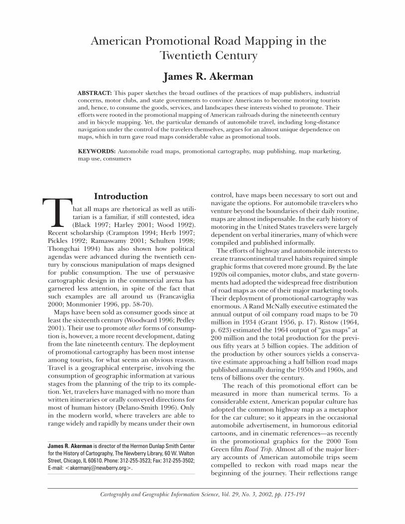
Figure 1. Detail of “Our trips,” on Gallup’s Transcontinental Highway Map of the United States. Gallup for Keystone Automobile Club, Kansas City, Kansas, 1934. (Courtesy, The Newberry Library).
176 Cartography and Geographic Information Science Vol. 29, No. 3 177
in road maps that they never see the country-side they pass through, and others who, having traced a route, are held to it as though held by flanged wheels to rails (Steinbeck 1962, pp. 22-23).Steinbeck recognized his superficial dependence
on road maps, but saw them as distractions from the landscape, and intense map readers as a class of uninteresting and uncreative people, unable to truly enjoy the freedoms automobile travel seemed to offer. Intriguingly, the endpapers of the first edition of Travels were printed with a pictorial map narrat-ing the route and events described in the book—a tacit recognition by the author or his publisher that maps could indeed convey more than navigational information.
Similar pictorial maps were regularly published as companions to navigational road maps by oil companies such as Sinclair and Sunoco in the 1930s and later. In other instances, navigational road maps were annotated by anonymous map users, in order to serve as souvenirs of memorable journeys. Among my favorites from several examples I have collected is a copy of a U.S. highway map issued by the Keystone Automobile Club about 1934. The front panel has been labeled “Our Trips.” Inside, the map offers an elegantly mute linear narrative of the wide-ranging travels throughout North America from 1934-38 of the first owners of the map (Figure 1) (Akerman 2000). Such transformations of road maps were fairly common, although the most common fate of an out-of-date map was quick disposal.
The promotional use of maps by automobile and highway interests nevertheless relied on both their fleeting, mundane practicality and their capacity to attach personal or cultural meaning to automobile travel. The advertising content (artwork and accom-panying text) of promotional road maps followed rhetorical strategies that in one sense paralleled, and were perhaps informed by, those developed by magazine advertisements beginning in the 1890s and refined in the 1920s (Ohmann 1996; Marchand 1985). It associated automobile tourism and the consump-tion of automobile goods and services with refine-ment, patriotism, family responsibility, and other positive values. It was important also that these were functioning maps. Their publishers and distributors recognized that consumption of whatever they were selling—be it gasoline, tires, motels, or roadside attractions—depended upon the ability of motoring tourists to travel easily and widely. So, the provision of maps was not just a medium for promotion, but also a precondition to consumption.
The Railroad PrecedentTwentieth-century promotional road mapping has a clear precedent in the nineteenth-century practices of American railroads. The debates of the late 1840s and 1850s concerning the need for an optimal routing of transcontinental railways were often contested with cartographic arguments (Hutawa 1849; Johnson 1853). And about this time simple maps and diagrams of proposed routes were first routinely attached to the annual reports of the companies constructing railroads in order to impress investors and lure new ones. In the 1860s and 1870s, similar maps appeared on timetables and handbills, in promotional tracts and guide-books for miners and farmers, and in business directories—anywhere the railroad industry was reaching out to potential customers. Job printers, such as the Chicago-based firms of Rand McNally and Poole Bros., began to specialize in this new market. They adopted a cartographic style that emphasized simplicity, often at the expense of geo-graphical fidelity. The idiomatic promotional rail-road map of the late nineteenth century showed railroads as straight or broadly curving lines that paid little attention to actual twists and turns, while naming at right angles to the line the maximum possible number of stations served. This “graphic list” design suggested to potential passengers that rail lines moved forthrightly and rapidly through the countryside, but at the same time served a large number of potential destinations. The sim-plicity of railroad promotional maps allowed the same designs to be adapted to the great variety of promotional publications that required them.
In the 1880s, maps formed part of the promotional barrage designed to foster the growth of railroad tour-ism, particularly in the West, where railroads played a critical role in the creation and development of several national parks and other tourist destinations (Carr 1998; Fifer 1988; Hyde 1990; Runte 1984; Rothman 1998, pp. 50-112). The brochures and guidebooks promoted railroad access to parks in the West and were rich in iconography that evoked the sublimity and beauty of the landscapes they described. They were occasionally accompanied by large-scale maps rich in topographic representation concerned with evoking a locality’s appeal as a tourist destination. More typically, promotional publications for railroad tourists included only small-scale schematic maps that put travel destinations in a broad geographical context emphasizing the exclusive or advantageous access offered by the sponsoring railroad.
Railroad promotional maps could afford to be schematic because rail travelers had little need for maps except for route planning. Railroad patrons
178 Cartography and Geographic Information Science Vol. 29, No. 3 179
did not drive the train, nor did they determine its course or schedule. Their interest in geography, in practical terms, rested entirely upon its relationship to the timetable, the rail passenger’s main naviga-tional tool. In contrast, the map involvement of the motoring tourist was necessarily of another order of magnitude—motoring travelers were the naviga-tors. Limited only by what the roads and related infrastructure would allow, they chose the speed and direction of their travel, the time and place of their rest stops, and the nature of their vehicle. Far from passively taking in the landscape presented to them by the path of a train they did not control, they had the power to choose which landscapes they would see and the pace at which they saw them. The seemingly limitless possibilities of automobile travel, however, carried with them dependence upon geographical information—and upon good roads. Away from the rigid dependability of steel rails, motorists were on their own, especially early in the automobile age; this was the bargain struck by their move from rails to roads.
Road Maps and Early Road Making
At the end of the nineteenth century, respon-sibility for the construction and maintenance of American roads fell almost entirely to local governments. In 1890, roughly 34 percent of the street mileage in the nation’s fifty largest cities was improved in some way (Knowlton 1964, p. 117), but since rural communities had few financial resources to finance road maintenance, country roads remained extremely poor. Motorists wish-ing to venture between cities and towns did so at considerable risk, if not to life and limb, then to the good health of their machines and to their timetable (Hugill 1982; Jakle 1985, pp. 101-19; Preston 1991). Knowledge of local roads suitable for automobile use was essential, but not widely available in convenient formats. Because auto-mobile ownership was impractical for all but the wealthiest Americans until about 1908 (when Ford introduced the Model-T), commercial demand for road maps was low, and established mapping firms were slow to specialize in the genre. Those that did mostly produced maps of the densely settled areas of the Northeast, where roads were relatively good, inter-urban distances short, and automobile own-ership relatively high.
Maps that provided practical guidance over longer distances to less traveled areas were in short supply, prompting the emergence of a peculiar breed of
amateur “pathfinders” and “trailblazers,” who took pleasure (and profit) from surveying intercity routes and publishing the results in the form of verbal itineraries or “logs.” The origin of this phenom-enon may be traced to the many sporting bicycle clubs that sprang up around the country during the 1880s and 1890s. At the urging of their national organization, the League of American Wheelmen (LAW), many of these clubs surveyed and mapped road conditions in their region. Members in the field took notes on all of the roads in their vicinity, logging distances, identifying those that were best suited to bicycles and noting their local gradients and surface quality. Back at club headquarters, “road book” committees compiled this information into digestible form, usually as little atlases (e.g., Randall and Hering 1898).
The bicycle was overtaken by the automobile, often at the instigation of former bicycle enthusi-asts. Publication of cycling maps effectively ceased in the United States for three quarters of a century as men such as William Rishel took up a new avo-cation. A Salt Lake City-based cycling enthusiast in the 1890s, Rishel made the transition to motorist in 1900. Soon he was busy logging and mapping routes from Salt Lake City to destinations across Utah and into adjacent states. He supplied this information through his own touring agency, which affiliated with the local branch of the American Automobile Association. Rishel’s operations expanded when he became a full-time automobile columnist for the Salt Lake City Tribune; by 1920 he had logged 20,000 miles of roads in the southwest, many of which became the basis for state and U.S. routes in the area (Rishel 1920; Rishel 1983).
Other well known pathfinders included A.L. Westgard, who first distinguished himself as the
“pilot” for the annual Glidden reliability tours, and R.H. “Pathfinder” Johnston, the advertising director for the White Motorcar Company, who logged several southern routes from 1908-10. Like Rishel, both were skilled drivers and navigators with no particular train-ing in mapping or surveying who parlayed a hobby into a professional pursuit. In 1915, Westgard rose to become Director of Transcontinental Highways for the National Highways Association (NHA), a national good roads lobbying group. Johnston issued his routes as part of a series of logs published by his employer, and later as part of the Automobile Blue Book for 1910 (Preston 1991, pp. 100-103).
Highway associations such as the NHA, dedicated to the blazing, improvement, and promotion of par-ticular interstate and transcontinental routes, were among the most prolific early publishers of promo-tional cartography. Midwestern manufacturers of
178 Cartography and Geographic Information Science Vol. 29, No. 3 179
automobiles and automobile parts formed the best known of these associations, the Lincoln Highway Association, in 1912. Its most tangible and immediate goal was the marking and improvement of a route
from New York to San Francisco. But the sponsors also hoped that the Highway would demonstrate to the general public and political leaders the desirability and the practicality of transcontinental auto-mobile travel, hastening the construc-tion of good automobile highways and ensuring the future prosperity of their companies (Hokanson 1988; Lincoln Highway 1935). Most of the several hundred highway associations that flourished in the 1910s and 1920s had similar if more modest goals. The Ozark Trails Association, which identified and marked a network of interstate highways stretching from St. Louis to New Mexico, was founded by William Hope Harvey, a prominent Arkansas businessman, who hoped to improve access from the Midwest to his mountain resort (Krim 1996). South Dakota businessmen, anx-ious to route traffic across the northern Great Plains through their hometowns, founded the Yellowstone Trail, linking Boston and Seattle in 1912 (Ridge and Ridge 1998).
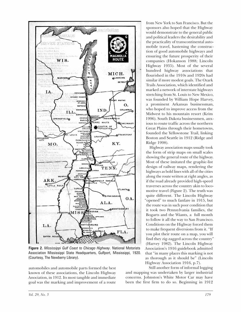
Highway association maps usually took the form of strip maps on small scales showing the general route of the highway. Most of these imitated the graphic-list design of railway maps, rendering the highways as bold lines with all of the cities along the route written at right angles, as if the road already provided high-speed traverses across the country akin to loco-motive travel (Figure 2). The truth was quite different. The Lincoln Highway
“opened” to much fanfare in 1915, but the route was in such poor condition that it took two Pennsylvania families, the Bogarts and the Wiants, a full month to follow it all the way to San Francisco. Conditions on the Highway forced them to make frequent diversions from it. “If you plot their route on a map, you will find they zig-zagged across the country” (Harvey 1982). The Lincoln Highway Association’s 1916 guidebook admitted that “in many places this marking is not as thorough as it should be” (Lincoln Highway Association 1916, p.7).
Still another form of informal logging and mapping was undertaken by larger industrial concerns. Johnston’s White Motor Car may have been the first firm to do so. Beginning in 1912
Figure 2. Mississippi Gulf Coast to Chicago Highway. National Motorists Association Mississippi State Headquarters, Gulfport, Mississippi, 1920. (Courtesy, The Newberry Library).
180 Cartography and Geographic Information Science Vol. 29, No. 3 181
the B.F. Goodrich Rubber Company’s National Touring Bureau published a series of state maps covering the entire country showing the
“main market highways.” Accompanying guidebooks logged these roads in detail, noting that they had been
“surveyed by Goodrich path-finder cars and roadmarker trucks.” The company also offered to send its “Goodrich Guide Posts” “to any respon-sible party for erection at a confusing turn or xroad [sic] on any of these routes” (B.F. Goodrich Rubber Company 1917).
The standard for all of these publications was set by the long-lived and extensive “Blue Books” compiled and published by the Automobile Blue Book Company. First issued in 1901, they initially cov-ered only the Northeast, but by 1911 the guides covered the entire country, and by 1920 they reached twelve volumes. The Blue Books were enormous undertakings, represent-ing considerable research by local (but generally anonymous) route loggers. Most volumes exceeded one thousand pages and logged several hundred routes. Invaluable though they were to early motor-ists, many found them cumbersome and difficult to follow. One motorist remembered that “Whoever had the seat of honor beside the driver got the Blue Book job and spent the day with his nose glued to the fine-typed pages and read aloud each direction, but never quite in time to prevent the wrong turn” (Hokanson 1988, p. 91).
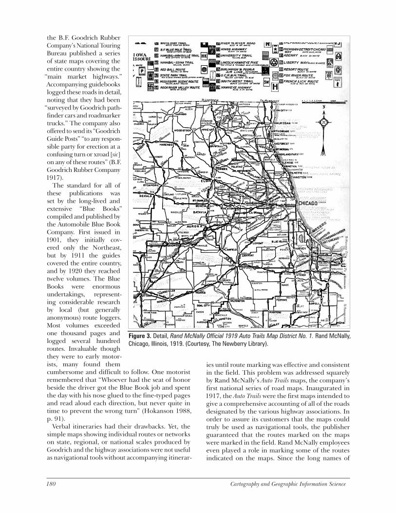
Verbal itineraries had their drawbacks. Yet, the simple maps showing individual routes or networks on state, regional, or national scales produced by Goodrich and the highway associations were not useful as navigational tools without accompanying itinerar-
ies until route marking was effective and consistent in the field. This problem was addressed squarely by Rand McNally’s Auto Trails maps, the company’s first national series of road maps. Inaugurated in 1917, the Auto Trails were the first maps intended to give a comprehensive accounting of all of the roads designated by the various highway associations. In order to assure its customers that the maps could truly be used as navigational tools, the publisher guaranteed that the routes marked on the maps were marked in the field. Rand McNally employees even played a role in marking some of the routes indicated on the maps. Since the long names of
Figure 3. Detail, Rand McNally Official 1919 Auto Trails Map District No. 1. Rand McNally, Chicago, Illinois, 1919. (Courtesy, The Newberry Library).
180 Cartography and Geographic Information Science Vol. 29, No. 3 181
the “trails” were difficult to abbreviate, each was assigned a number on the map, saving space and leaving room for advertisements (Figure 3) (Akerman 1993; Brink 1926).
With the passage of the first federal road aid acts in 1916 and 1921, state and federal intervention in route marking and mapping began in earnest. In the early 1920s many states adopted the practice of numbering their primary routes and marking them in the field. This practice was re-enforced in 1925 by a federal law that also called for numbering and marking a federal interstate highway system. The details of the national system were formally adopted in 1926 and marked nationwide by 1928. The shift in road designation, maintenance, and marking from ad hoc private and commercial efforts to state agen-cies meant that route marking was more consistent and reliable, and automobile travel more conve-nient. It also meant that the bulky and expensive route log navigating was rapidly becoming obsolete. Henceforth, in almost any part of the country, a simpler and cheaper road map, showing little more than the network of numbered highways, was all that
most motor travelers required in order to navigate throughout a state or region. The stage was set for promotional mapping on a broad scale.
The Archetype: Oil Company Road MapsAutomobile tourism as we know it is a product of the 1920s. Between 1916 and 1929, pri-vate motor vehicle registrations jumped from 3.3 million to 23 million. Over the same period annual inter-city passenger miles logged by automobile leaped from 42 billion miles to 2 trillion—75 percent of which was accounted for by private vehicles (Stover 1997, p. 194). To serve growing legions of inter-city motorists, new types of accommodation—tourist camps and motels—were estab-lished at the edges of towns and cities in locations more conve-nient and cheaper than down-town hotels (Belasco 1979). The first roadside attractions devel-oped specifically for motoring tourists date from this period as well, and the new National Park
Service embarked upon an ambitious program of road construction to facilitate automobile access to the nation’s major scenic attractions (Carr 1998).
The first structures designed specifically for distrib-uting gas and oil were in place by 1913 (Margolies 1993, pp. 27-28). During the years that followed, regional and national oil refiners and distributors consolidated their control over these local distribu-tors, developed the use of distinctive brands, and standardized the architecture of their stations and corporate logos. The petroleum products offered by one branded station, however, differed little from those offered by another. Gas and oil retailers thus established consumer loyalty by propagating dis-tinctive and positive corporate images and stressing personal service, including the offer of free travel advice (Jakle and Sculle 1994). As a marketing tool, the road map complemented the distinctive look of a company’s gas stations. As pure advertising these maps helped refine corporate images and promote specific products. But they differed from other adver-tising media in that they also provided something
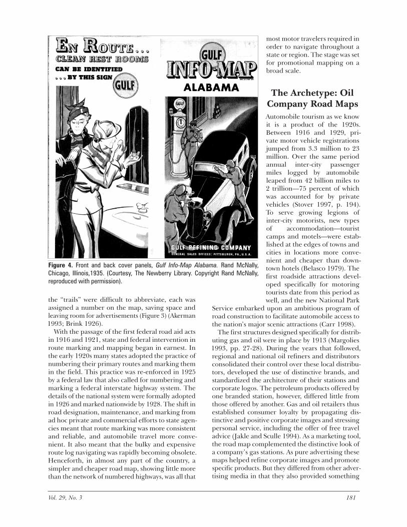
Figure 4. Front and back cover panels, Gulf Info-Map Alabama. Rand McNally, Chicago, Illinois,1935. (Courtesy, The Newberry Library. Copyright Rand McNally, reproduced with permission).
182 Cartography and Geographic Information Science Vol. 29, No. 3 183
motoring consumers genuinely valued: navigational information and travel advice at no apparent cost. The cost to the oil distributor was, in turn, reduced by the entry into the field of established commercial cartographers, such as Rand McNally.
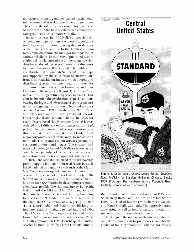
In many respects, Rand McNally’s approach to the oil company map business was merely a continua-tion of practices it refined during the last decades of the nineteenth century. In the 1870s it custom-ized simple diagrammatic maps for railroads to suit various rail clients. In the 1890s it published custom editions of its reference atlases for newspapers, which distributed the atlases as premiums or at discounts to their subscribers (Peters 1984). The publication and distribution of Rand McNally’s Auto Trails maps was supported by the solicitation of subscriptions from local roadside businesses, which bought and distributed a certain volume of maps in return for a prominent mention of their businesses and their locations on the map itself (Figure 3). The Auto Trails marketing strategy refined by sales manager H.M. Gousha included the production of special editions bearing the logos and advertising of sponsoring busi-nesses, and giving the location of branded stores or outlets (Akerman 1993). In the mid-1920s, Rand McNally’s road map business gravitated towards larger regional and national clients. In 1925, for example, a reduced-size Junior Auto Trails series was ordered by 21 different oil companies (Brink 1926, p. 46). The company embarked upon a strategy at this time that greatly enlarged the visible identity of major corporate clients on the maps by introducing more advertising and custom artwork promoting corporate products and images. These customized maps acknowledged Rand McNally’s identity as the compiler and publisher of the map only in the form of modest marginal notes or copyright statements.
At first, Rand McNally was joined in this drift towards proxy mapping for major industrial clients by estab-lished national cartographic rivals such as the Clason Map Company, George F. Cram, and Hammond, all of which dropped out of this trade by the early 1930s. Several smaller firms successfully specialized in the business for a few decades by developing a regional client base, notably The National Survey, Langwith, Gallup, and the Midwest Map Company. One of these smaller firms, the General Drafting Company, founded in 1909, landed the lucrative account of the Standard Oil Company of New Jersey in 1923 (Later Esso/Humble and Exxon), establishing an intimate relationship that persisted into the 1980s. The H.M. Gousha Company was established by the former Auto Trails salesman and other former Rand McNally employees in 1926. Gousha quickly landed several of Rand McNally’s largest clients, among
them Standard of Indiana and Conoco in 1927, and Shell, Deep Rock, Gulf, Pan-Am, and White Star in 1928. A period of intense rivalry between Gousha and Rand McNally was marked by aggressive trade advertising as well as innovation and imitation in marketing and product development.
The design of the road maps themselves stabilized so that only minor stylistic preferences—notably the choice of fonts, symbols, and schemes for classify-
Figure 5. Cover panel, Central United States, Standard. Rand McNally for Standard (Indiana), Chicago, Illinois, 1958. (Courtesy, The Newberry Library. Copyright Rand McNally, reproduced with permission).
182 Cartography and Geographic Information Science Vol. 29, No. 3 183
ing highways—distinguished the products of one map publisher from another. But the use of four-color cover art, advertising, and map graphics was expanded and customized to the needs of the client. No space on the map was left unused (Yorke and Margolies 1996). The backsides of the maps were graced with inset maps and pictorial tableaus advertis-ing products and services or offering travel tips and information. Map color was customized according to the specifications of the client—for instance, red and green line work for Sinclair, orange and blue for Gulf—corresponding with the color schemes of service station architecture, logos, and product branding, and reinforcing what Jakle and Sculle call “place-product packaging” (Jakle and Sculle 1994, pp. 36-47).
Map graphics and text mimicked emerging advertis-ing techniques, repeating corporate slogans—some of which were beginning to appear on corporate-spon-sored radio programs. Back panels of Sunoco’s 1941 maps, for example, urged consumers to “Keep up with the News of the World in your car and at home [with] Lowell Thomas, Sunoco news voice of the air,” noting that “In all the world there’s no gasoline like Nu-Blu Sun.” Corporate icons were repeated in every
possible instance, too. Sinclair’s famous dinosaur appeared in several elaborate tableaus on map covers during the 1930s. On 1933 covers, Dino carried a banner advertising that “Sinclair brings dinosaurs to life” at the Chicago World’s Fair. In 1934, he was a child’s toy being pulled on a cart in front of an opulent Tudor-style Sinclair Service Station. In 1935, he cavorted in a full-fledged Jurassic scene. Conoco’s familiar, inverted triangle logo not only appeared on covers and graphic panels, but also marked the location of Conoco service stations everywhere on its maps published in the 1930s to 1960s.
Explicit advertisements lauding the virtues of the lubricants and gasolines were common, too, but they took a back seat to tableaus making powerful, if oblique, links between brands and idealized social worlds—again borrowing a page from magazine and radio advertisements. These began with the construction of the ideal service station. Gulf “info-maps” for 1935 promoted the high standards of Gulf service, sporting images on the front cover of three gasoline attendants servicing a single car: one pumping gas, one washing the windshield, and one checking the oil (Figure 4). On the back panel, two well dressed women powder their noses in a spar-
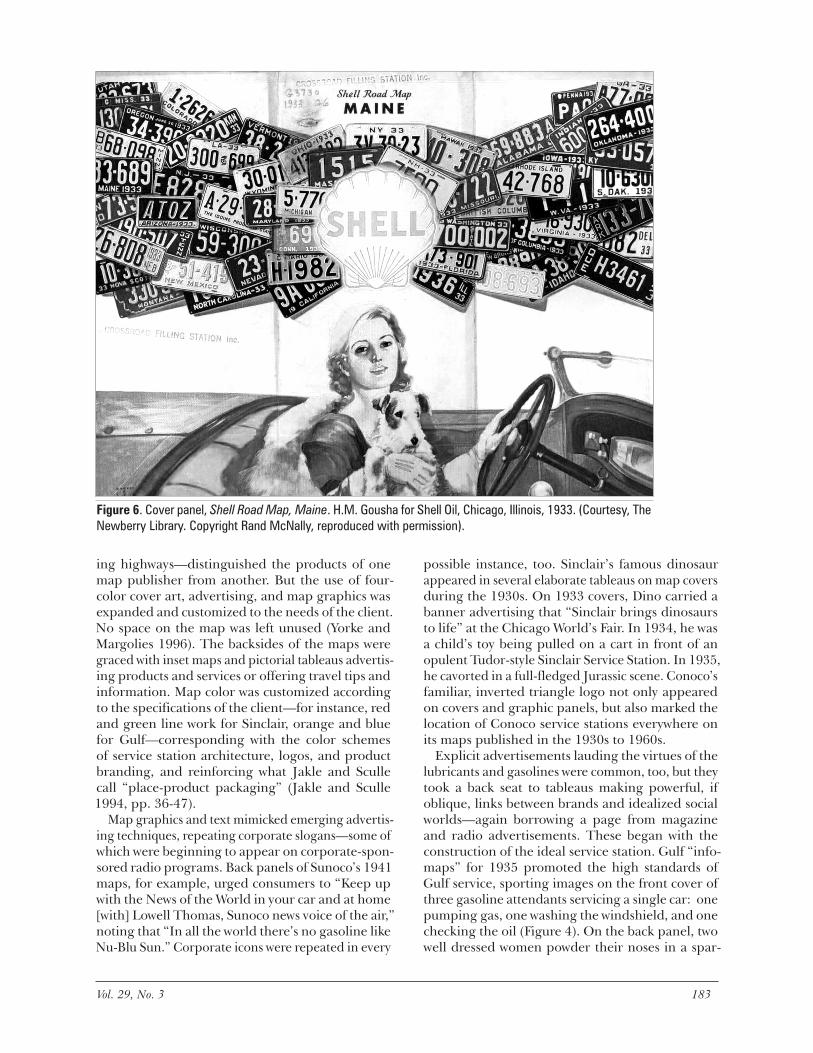
Figure 6. Cover panel, Shell Road Map, Maine. H.M. Gousha for Shell Oil, Chicago, Illinois, 1933. (Courtesy, The Newberry Library. Copyright Rand McNally, reproduced with permission).
184 Cartography and Geographic Information Science Vol. 29, No. 3 185
kling bathroom under text that proclaims “En route...clean restrooms can be identified…by this sign,” while yet another panel advises patrons to
“see your Gulf man” for directions. Service sta-tion personnel appear forever helpful and smiling, often assisting motorists with directions over an opened map (Figure 5).
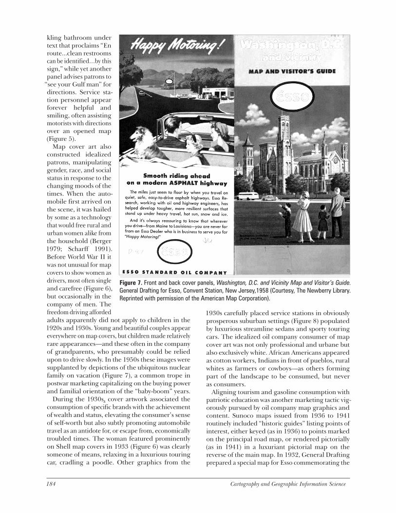
Map cover art also constructed idealized patrons, manipulating gender, race, and social status in response to the changing moods of the times. When the auto-mobile first arrived on the scene, it was hailed by some as a technology that would free rural and urban women alike from the household (Berger 1979; Scharff 1991). Before World War II it was not unusual for map covers to show women as drivers, most often single and carefree (Figure 6), but occasionally in the company of men. The freedom driving afforded adults apparently did not apply to children in the 1920s and 1930s. Young and beautiful couples appear everywhere on map covers, but children made relatively rare appearances—and these often in the company of grandparents, who presumably could be relied upon to drive slowly. In the 1950s these images were supplanted by depictions of the ubiquitous nuclear family on vacation (Figure 7), a common trope in postwar marketing capitalizing on the buying power and familial orientation of the “baby-boom” years.
During the 1930s, cover artwork associated the consumption of specific brands with the achievement of wealth and status, elevating the consumer’s sense of self-worth but also subtly promoting automobile travel as an antidote for, or escape from, economically troubled times. The woman featured prominently on Shell map covers in 1933 (Figure 6) was clearly someone of means, relaxing in a luxurious touring car, cradling a poodle. Other graphics from the
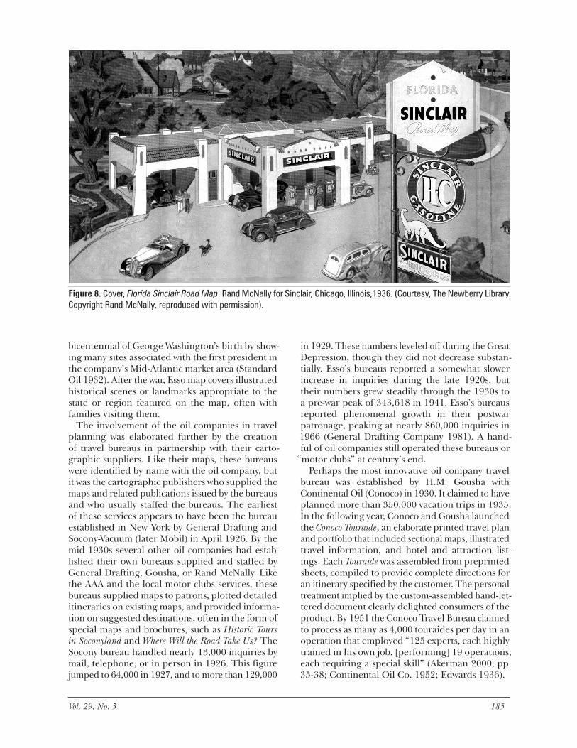
1930s carefully placed service stations in obviously prosperous suburban settings (Figure 8) populated by luxurious streamline sedans and sporty touring cars. The idealized oil company consumer of map cover art was not only professional and urbane but also exclusively white. African Americans appeared as cotton workers, Indians in front of pueblos, rural whites as farmers or cowboys—as others forming part of the landscape to be consumed, but never as consumers.
Aligning tourism and gasoline consumption with patriotic education was another marketing tactic vig-orously pursued by oil company map graphics and content. Sunoco maps issued from 1936 to 1941 routinely included “historic guides” listing points of interest, either keyed (as in 1936) to points marked on the principal road map, or rendered pictorially (as in 1941) in a luxuriant pictorial map on the reverse of the main map. In 1932, General Drafting prepared a special map for Esso commemorating the
Figure 7. Front and back cover panels, Washington, D.C. and Vicinity Map and Visitor’s Guide. General Drafting for Esso, Convent Station, New Jersey,1958 (Courtesy, The Newberry Library. Reprinted with permission of the American Map Corporation).
184 Cartography and Geographic Information Science Vol. 29, No. 3 185
in 1929. These numbers leveled off during the Great Depression, though they did not decrease substan-tially. Esso’s bureaus reported a somewhat slower increase in inquiries during the late 1920s, but their numbers grew steadily through the 1930s to a pre-war peak of 343,618 in 1941. Esso’s bureaus reported phenomenal growth in their postwar patronage, peaking at nearly 860,000 inquiries in 1966 (General Drafting Company 1981). A hand-ful of oil companies still operated these bureaus or
“motor clubs” at century’s end.Perhaps the most innovative oil company travel
bureau was established by H.M. Gousha with Continental Oil (Conoco) in 1930. It claimed to have planned more than 350,000 vacation trips in 1935. In the following year, Conoco and Gousha launched the Conoco Touraide, an elaborate printed travel plan and portfolio that included sectional maps, illustrated travel information, and hotel and attraction list-ings. Each Touraide was assembled from preprinted sheets, compiled to provide complete directions for an itinerary specified by the customer. The personal treatment implied by the custom-assembled hand-let-tered document clearly delighted consumers of the product. By 1951 the Conoco Travel Bureau claimed to process as many as 4,000 touraides per day in an operation that employed “125 experts, each highly trained in his own job, [performing] 19 operations, each requiring a special skill” (Akerman 2000, pp. 35-38; Continental Oil Co. 1952; Edwards 1936).
bicentennial of George Washington’s birth by show-ing many sites associated with the first president in the company’s Mid-Atlantic market area (Standard Oil 1932). After the war, Esso map covers illustrated historical scenes or landmarks appropriate to the state or region featured on the map, often with families visiting them.
The involvement of the oil companies in travel planning was elaborated further by the creation of travel bureaus in partnership with their carto-graphic suppliers. Like their maps, these bureaus were identified by name with the oil company, but it was the cartographic publishers who supplied the maps and related publications issued by the bureaus and who usually staffed the bureaus. The earliest of these services appears to have been the bureau established in New York by General Drafting and Socony-Vacuum (later Mobil) in April 1926. By the mid-1930s several other oil companies had estab-lished their own bureaus supplied and staffed by General Drafting, Gousha, or Rand McNally. Like the AAA and the local motor clubs services, these bureaus supplied maps to patrons, plotted detailed itineraries on existing maps, and provided informa-tion on suggested destinations, often in the form of special maps and brochures, such as Historic Tours in Soconyland and Where Will the Road Take Us? The Socony bureau handled nearly 13,000 inquiries by mail, telephone, or in person in 1926. This figure jumped to 64,000 in 1927, and to more than 129,000
Figure 8. Cover, Florida Sinclair Road Map. Rand McNally for Sinclair, Chicago, Illinois,1936. (Courtesy, The Newberry Library. Copyright Rand McNally, reproduced with permission).
186 Cartography and Geographic Information Science Vol. 29, No. 3 187
Variations on the Theme
The free gas station map is the best known type of promotional road map-ping and was, in its heyday, the most common. This survey of promotional road mapping would not be complete, however, without briefly considering the products of the other two major institutional sources—motor clubs and state governments—both of which have outlived the free oil company map into the twenty-first century.
Like the bicycle clubs before them, automobile clubs began life primarily as sporting organizations and ombudsmen for the interests of private motor-ists. And like the League of American Wheelmen and the highway associations, they were active in the political arena as well, lobbying for good roads legislation, local road improvements, and effective traffic and safety regulations. To the general public they were (and are) better known as a source of member services, such as roadside assistance and insurance, and especially as a source of travel information and maps. Two national automobile clubs existed early in the twentieth century. The Automobile Club of America (ACA) was founded in New York in 1899 and maintained a strong Northeastern and mostly wealthy membership until the American Automobile Association absorbed it in the 1920s. The ACA pub-lished its own book of route logs in 1900, and by 1909 it had published twenty maps, mostly of highly localized regions (Ristow 1964, p. 622).
The American Automobile Association (AAA) was founded in 1902 by the amalgamation of several local clubs. At first, the AAA was content to endorse the annual editions of the Automobile Blue Book, and from at least the time it took on the sponsorship of the annual Glidden reliability runs, it was active in
“blazing” interregional automobile routes. It began publishing its own local road maps within several years of its founding; a national cartographic office
began operations in Washington soon after 1910, and by 1926 this office was the exclusive producer of the state, regional, and city maps the national AAA distributed to its members. By 1952 this operation was distributing 40 million maps per year, a figure that exceeded the annual circulation of any one oil company. Unlike the oil companies, the AAA’s map distribution showed no signs of abating in the 1970s, reaching 180 million in 1974 (Ottness 1975, p. 8).
Several of the local clubs affiliated with the American Automobile Association also published their own maps. The Keystone Automobile Club of Philadelphia, for example, distributed a number of maps of states in its market area from at least the early 1920s (pre-pared by General Drafting). The Automobile Club of Southern California was renowned early in the century for its pathfinding in the Southwest and its detailed cartographic route cards (strip maps) of major western routes. The AAA’s own personalized route plans, called Triptiks, appeared in the 1950s and remain one of the icons of the industry, though they are now superseded by the AAA’s Internet Triptik and other online route-planning services.
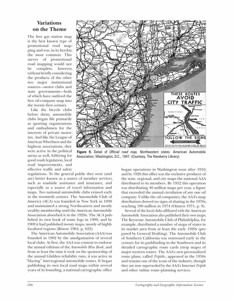
Figure 9. Detail of Official road map, Northeastern states. American Automobile Association, Washington, D.C., 1947. (Courtesy, The Newberry Library).
186 Cartography and Geographic Information Science Vol. 29, No. 3 187
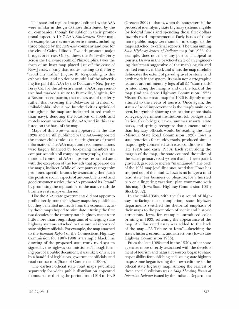
The state and regional maps published by the AAA were similar in design to those distributed by the oil companies, though far subtler in their promo-tional aspect. A 1947 AAA Northeastern States map, for example, carries nine advertisements, including three placed by the Auto-Lite company and one for the city of Cairo, Illinois. Five ads promote major bridges or ferries. One of these, the Pennsville Ferry across the Delaware south of Philadelphia, takes the form of an inset map placed just off the coast of New Jersey, noting that routes leading to the ferry
“avoid city traffic” (Figure 9). Responding to this exhortation, and no doubt mindful of the advertis-ing fee paid the AAA by the Delaware−New Jersey Ferry Co. for the advertisement, a AAA representa-tive had marked a route to Farmville, Virginia, for a Boston-based patron, that makes use of the ferry rather than crossing the Delaware at Trenton or Philadelphia. About two hundred cities sprinkled throughout the map are indicated in red (rather than navy), denoting the locations of hotels and motels recommended by the AAA, and in this case listed on the back of the map.
Maps of this type—which appeared in the late 1920s and are still published by the AAA—supported the motor club’s role as a clearinghouse of travel information. The AAA maps and recommendations were largely financed by fee-paying members. In comparison with oil company cartography, the pro-motional content of AAA maps was restrained and, with the exception of the few ads that appeared on the maps, indirect. While oil company cartography promoted specific brands by associating them with the positive social aspects of automobile travel and good customer service, the AAA promoted its “brand” by promoting the reputations of the many roadside businesses its maps endorsed.
Like the AAA, state governments did not appear to profit directly from the highway maps they published, but they benefited indirectly from the economic activ-ity these maps hoped to stimulate. During the first two decades of the century state highway maps were little more than rough diagrams of emerging state highway systems attached to the annual reports of state highway officials. For example, the map attached to the Biennial Report of the Connecticut Highway Commission for 1907-1908 is a simple black line drawing of the proposed state trunk road system signed by the highway commissioner. Though form-ing part of a public document, it was likely only seen by a handful of legislators, government officials, and road contractors (State of Connecticut 1909).
The earliest official state road maps published separately for wider public distribution appeared in most states during the period from 1914 to 1929
(Greaves 2002)—that is, when the states were in the process of identifying state highway systems eligible for federal funds and spending those first dollars towards road improvements. Early issues of these more public maps were similar in design to the maps attached to official reports. The unassuming State Highway System of Indiana map for 1925, for example, does not make any particular appeal to tourists. Drawn in the practiced style of an engineer-ing draftsman suggestive of the map’s origin and printed entirely in black and white, the map carefully delineates the extent of paved, gravel or stone, and earth roads in the system. Its main non-cartographic features are rudimentary logs of all 55 “state roads” printed along the margins and on the back of the map (Indiana State Highway Commission 1925). Missouri’s state road map for 1926 is slightly more attuned to the needs of tourists. Once again, the status of road improvement is the map’s main con-cern, but symbols showing the location of hospitals, colleges, government institutions, toll bridges and ferries, free bridges, caves, summer resorts, state parks, and springs recognize that someone other than highway officials would be reading the map (Missouri State Road Commission 1926). Iowa, a state notorious for muddy roads, produced similar maps largely concerned with road conditions in the late 1920s and early 1930s. Each year, along the margin of the map, the state counted the miles of the state’s primary road system that had been paved, graveled, graded, or merely “maintained.” The back of the 1931 map joyfully announced that “Iowa has stepped out of the mud…. Iowa is no longer a mud road state! For business or pleasure, for a hurried trip or a lingering vacation, plan your route with this map” (Iowa State Highway Commission 1931; Block 2002).
In the mid-1930s, with the first round of high-way surfacing near completion, state highway departments switched the rhetorical emphasis of their maps to the promotion of scenic and historic attractions. Iowa, for example, introduced color printing in 1933, softening the appearance of the map. An illustrated essay was added to the back of the map—”A Tribute to Iowa”—sketching the state’s history, economy, and attractions (Iowa State Highway Commission 1933).
From the late 1920s and in the 1930s, other state agencies more directly associated with the develop-ment of tourism and natural resources began to share responsibility for publishing and issuing state highway maps. Some began issuing their own editions of the official state highway map. Among the earliest of these special editions was a Map Showing Points of Interest in Indiana issued by the Indiana Department
188 Cartography and Geographic Information Science Vol. 29, No. 3 189
of Conservation in 1929 (Indiana Department of Conservation 1929), which listed and located 84 places of interest and 22 parks and other facilities under the department’s jurisdiction. Reflecting their increased interest in maps as tools of economic devel-opment, some states followed the practice of the oil companies by turning to cartographic publishers to refine the look of their maps. These collaborations included the State of Michigan with Rand McNally; Illinois, Montana, Nebraska, and Utah with Gousha; Alabama, New York, New Jersey, and Vermont with General Drafting; and Maine with The National Survey. Colorful photographic tableaus and text detailing a state’s physical virtues and its cultural and historical attractions took the place of more practical information about construction and traffic regulations that had dominated earlier works. Four-color cover art rivaling what the oil companies were producing featured idealized landscapes, signature landmarks, and historical scenes.
This trend continued after the war with increasing sophistication. The back of Texas’s 1951 state high-way map sported a faux photo album of campfires, cattle, beaches, and missions and the exhortation to “See Texas First” (Texas Highway Department 1951). Washington’s 1950 official state highway map (prepared by Rand McNally) included a dramatic panorama showing a suggested scenic drive through the volcanoes of the Cascade Range, accompanied by photographs of the natural highlights one would encounter along the way (Washington Department of Highways 1950). By the 1970s, lists of state parks and their services were standard fare on most state-issued maps, which often included promotions of privately operated attractions.
The 1950s expansion of automobile tourism went hand-in-hand with a renewal and expansion of highway infrastructure, culminating in the pas-sage of the 1956 act creating the federal system of interstate superhighways that dominate the American roadscape today. Artwork for many official state highway maps from this period and well into the 1960s focused on highway construction, reflecting the nation’s early fascination with the speed and technology of interstate highways. The 1960 Illinois Official Highway Map proudly displays the newly built complex interchange between Interstate Highways 90 and 294, U.S. Route 30 and Illinois Route 56, known until recent reconstruction as the “Hillside Strangler” for its traffic congestion (State of Illinois 1960). Similarly, the cover of the 1966 Official State Highway Map for Texas features a dramatic photo-graph of a soaring new bridge over a rushing river (Texas Highway Department 1966).
As the novelty of the new superhighways waned in the 1970s, many state-issued maps returned to
an emphasis on historical, cultural, and physical landscapes. From the early 1970s to the mid-1980s, the reverse of the Nebraska’s official state highway map included a tableau devoted to the “Platte River Road,” the historic route of the Oregon, California, and Mormon Trails that bisects the state along an east-west axis. This promotional appeal to pioneer days was particularly useful to Nebraska, since the Platte River Road is essentially the route of Interstate 80, the main route from the Upper Midwest and the Northeast to the attractive tourist destinations of the Central Rockies, Great Basin, and Northern California. Adjacent Kansas, which had an equally strong historical association with pioneer travel and the Old West, emphasized this link far less explic-itly in its official state road maps, perhaps because Interstate 70, the main east-west superhighway through that state, does not parallel for any great length any of the state’s well-known pioneer trails (including the Santa Fe and the Chisholm Trails). Pictorial tableaus on Kansas state maps from the 1960s, notably the map for the state’s centennial in 1961, referred prominently to these trails, but in the 1970s and 1980s the state abandoned these in favor of inset maps featuring major cities and the routes of interstate highways. Farther south along the same longitude, Oklahoma published a series of tourist-oriented tableaus on their state maps on varying themes throughout the 1970s and 1980s, including
“roadside wildflowers” (Oklahoma Department of Highways 1975); “this land is our land” (Oklahoma Department of Highways 1976); “the Sooners of 1889 and the state’s Indian communities;” and “Oklahoma wildlife” (Oklahoma Department of Transportation 1977). In the 1990s, for reasons that seem to par-allel Nebraska’s embrace of the Platte River Road, Oklahoma State road maps settled on Route 66 as a major promotional hook. Created in 1926, this most famous of the original federal trunk highways is now superseded in Oklahoma by Interstates 44 and 40, which link St. Louis, Chicago, and points east with destinations in the desert Southwest and Southern California. Ironically, the promotional tactic adopted by Nebraska and Oklahoma implicitly recognized that each state would not be the ultimate destina-tion of most interregional tourists, and could hope perhaps to delay weary westbound motorists for no more than a day or two to visit a handful of sites near the interstate.
A survey of the promotional tactics of official state highway maps produced in the final decades of the twentieth century reveals no clear prevailing pattern. States such as Arizona and New Mexico have regularly published road maps that feature stunning photographs of their desert landscapes,
188 Cartography and Geographic Information Science Vol. 29, No. 3 189
mountains, and canyons. Tennessee, on the other, publishes a bland map whose reverse features an interstate highway guide and city maps, in spite of the fact that Nashville, Memphis, and the Great Smoky Mountains are important tourist destinations in their own right. Clearly, such differences reflect differences in local civic and governmental culture that further study might reveal.
ConclusionBy the mid-1970s, the love affair with interstate highways had ended along with Americans’ unconditional love for the automobile. Concerns about air pollution and traffic congestion, the Oil Crisis, social criticism of urban sprawl and the destruction of urban neighborhoods by express-way construction, and concern about the impact of highway construction on wilderness areas put the automobile and highway interests on the defensive (Berger 1993; Lewis 1997). This change of heart was reflected in the declining distribution of road maps. From its peak of 34.5 million maps in 1965, the Esso/General Drafting production fell to less than 25 million in 1972, and to 7.5 million in 1979 (General Drafting Company 1981). By the early 1980s, Exxon was the only major oil company still offering free road maps to its customers.
Already in 1968, the oil companies were publicly fretting over the 5-10 cents per map they paid for a product they felt forced to give away. “We would charge for [maps] tomorrow if someone else would do it too,” lamented the director of travel promo-tions at Mobil. An official of the American Petroleum Institute observed that consumer expectations limited the options of the oil companies. “No one could cut out the free maps unless everyone else did” (St. Louis Post-Dispatch 1968). Yet barely a decade later, the free “gas map” was indeed nearly extinct. The oil companies blamed the demise of this former cornerstone of their marketing strategy on the Oil Crisis, inflation, and consumer indifference. Even the interstate was singled out because it supposedly made it hard for motorists to get lost. I am more inclined to blame the decline of the road map to changes in the marketing of gasoline. About 1955 a Shell internal publication could, without any trace of irony, ask Shell dealers to embrace the moment when “a regular customer asks for a Shell map:”
[T]he chances are pretty good that’s he’s going somewhere. Ask him about the trip; show an interest in it; and suggest a Shellubrication before he leaves…. When a stranger asks for a map, give him a pleasant smile and a courte-
ous word along with it. A little friendliness goes a long way toward making a new customer. Ask him if [he] needs any help in finding his way; and if he does, take pains to give him clear directions (Shell 1955).Within two decades the disappearance of the full-
service gas station in favor of the self-service outlet and convenience store formats effectively eliminated the conditions in which this exchange could take place. These conditions still exist for state-sponsored highway maps.
Since the 1930s states have absorbed the expense of producing attractive promotional road maps as part of a broader public relations strategy. The various state tourism bureaus play perhaps an even greater role than they did in the past as clearinghouses of visitor information. Each U.S. state still provides free road maps to everyone who requests them. Most operate elaborate Web sites that dispense touring information; provide an assortment of online maps and suggested itineraries; offer links to other govern-ment, non-profit, and commercial sites of interest to tourists; and mail paper maps and brochures to site visitors upon request. The same service is roughly duplicated in state “welcome centers” that motorists encounter every time they cross a state line on an interstate highway. Since the 1970s, nevertheless, many states have experimented with the practice of issuing their maps in biennial editions to reduce costs. Alabama, Connecticut, Illinois, Indiana, Kentucky, Minnesota, Missouri, Montana, Oregon, and Washington adopted this practice permanently, while North Carolina and Wisconsin reverted to issu-ing annual editions during the period of prosperity and fat state budgets of the 1990s.
Still distributed by request to members, AAA maps are also sold at competitive prices to non-members. New paper map products (such as the state atlases published by the DeLorme Map Company), as well as digital in-car navigation systems, digital route planners, and Internet-based road maps have changed the landscape of the business. Even so, Internet-based road mapping and digital route planning products support themselves by inserting references to subscribing businesses or by display-ing banner advertisements or hot links to related services and websites. Despite their technological sophistication, these new road map forms differ little in their promotional approach from the Auto Trails maps issued by Rand McNally in the early 1920s. As long as private automobiles are used for recreational purposes, consumers’ dependence on navigational information will drive the promotion of automobile and highway products and services through the distribution of road maps.
190 Cartography and Geographic Information Science Vol. 29, No. 3 191
REFERENCESAkerman, J.R. 1993. Selling maps, selling highways:
Rand McNally’s ‘Blazed Trails’ program. Imago Mundi 45: 77-89.
Akerman, J.R. 2000. Private journeys on public maps: A look at inscribed road maps. Cartographic Perspectives 35: 27-47.
Belasco, W.J. 1979. Americans on the road: From autocamps to motels, 1910-1945. Cambridge, Massachusetts: MIT Press.
B.F. Goodrich Rubber Company. 1917. The Illinois and Wisconsin Goodrich route book. Akron, Ohio: B. F. Goodrich Rubber Company.
Berger, K.T. 1993. Where the road and sky collide: America through the eyes of its drivers. New York, New York: Henry Holt.
Berger, M.L. 1979. The Devil Wagon in God’s Country: The automobile and social change in rural America, 1893-1929. Hamden, Connecticut: Archon.
Black, J. 1997. Maps and politics. Chicago, Illinois: University of Chicago Press.
Block, D. 2002. Romantic and modernist images on twentieth century Iowa official state highway maps. The Newberry Library Slide Set 28. The Newberry Library, Chicago, Illinois.
Brink, J. G. 1926. “History of Rand McNally Auto Trails, 1908-1926.” Unpublished typescript, Rand McNally Collection, The Newberry Library, Chicago, Illinois.
Brinkley, D. 1994. The Majic Bus: An American odyssey. New York, New York: Anchor.
Bryson, B. 1989. The Lost Continent: Travels in small-town America. New York, New York: Harper & Row.
Carr, E. 1998. Wilderness by design: Landscape archi-tecture and the National Park Service. Lincoln, Nebraska: University of Nebraska Press.
Continental Oil Co. 1952. Touraide prepared espe-cially for Marjorie Henningsen. Continental Oil Co., [Denver].
Crampton, J. 1994. Cartography’s defining moment: The Peters Projection controversy. Cartographica 31 (4): 16-32.
Delano-Smith, C. 1996. Milieus of mobility: Early route, road, and itinerary maps. Paper given to “Maps on the move: Cartography for transportation and travel,” the Twelfth Kenneth Nebenzahl, Jr., Lectures in the History of Cartography. The Newberry Library, Chicago, Illinois.
Edwards, C. 1936. Conoco’s ‘Touraides’ do effective sales job. The Advertiser, November. pp. 40, 55.
Fifer, J.V. 1988. American progress: The growth of transport, tourist, and information industries in the nineteenth-century West seen through the life and times of George A. Crofutt, pioneer publicist of the transcontinental age. Chester, Connecticut: Globe Pequot.
Francaviglia, R. 2000. “Cover the Earth: The role of maps in advertising and promotion.” Paper pre-sented to “Maps and Popular Culture,” the Second Biennial Virginia Garrett Lectures in the History of Cartography. The University of Texas at Arlington, Arlington, Texas.]
General Drafting Company. 1981. “Historic facts and figures.” Internal memorandum, March 25, 1981, General Drafting Archives, The Newberry Library, Chicago, Illinois.
Grant, B. 1956. “Notes on the history of Rand, McNally and Company.” Unpublished document, Rand McNally Collection, The Newberry Library, Chicago, Illinois.
Greaves, M. 2002. Official maps master list. Road Map Collectors Association. [www.roadmaps.org/omml].
Harley, J.B (P. Laxton (ed.). 2001. The new nature of maps: Essays in the history of cartography. Baltimore, Maryland: Johns Hopkins University Press.
Harvey, D.W. 1982. Wiant-Bogart cross-country odyssey 1915. Privately published, Sweet Valley, Pennsylvania.
Heat-Moon, W.L. 1982. Blue highways: A journey into America. Boston, Massachusetts: Little, Brown.
Herb, G. 1997. Under the map of Germany. New York, New York: Routledge.
Hokanson, D. 1988. The Lincoln Highway: Main Street across America. Iowa City, Iowa: University of Iowa Press.
Hugill, P.J. 1982. Good roads and the automobile in the United States, 1880-1929. Geographical Review 72 (3): 327-49.
Hutawa, J. 1849. Map and profile sections showing the railroads of the United States, the several projected railways to the Pacific, and their connections. In: J. Loughborough, The Pacific telegraph and railway. St. Louis, Missouri: Charles & Hammond.
Hyde, A.F. 1990. An American vision: Far Western land-scape and American culture, 1820-1920. New York, New York: New York University Press.
Indiana Department of Conservation. 1929. Map show-ing points of interest in Indiana. Indiana Department of Conservation, [Indianapolis], Indiana.
Indiana State Highway Commission. 1925. State high-way system of Indiana. State Highway Commission, Indianapolis, Indiana.
Iowa State Highway Commission. 1931. Iowa primary road map. Iowa State Highway Commission, Ames, Iowa.
Iowa State Highway Commission. 1933. Iowa highway map 1933. Iowa State Highway Commission, Ames, Iowa.
Jakle, J.A. 1985. The tourist: Travel in twentieth-century North America. Lincoln, Nebraska: University of Nebraska Press.
Jakle, J.A., and K.A. Sculle, 1994. The gas station in America. Baltimore, Maryland: Johns Hopkins University Press.
Johnson, E.F. 1853. Map of the proposed northern route for a railroad to the Pacific…1853. In: Railroad to the Pacific, northern route. New York, New York: Railroad Journal Job Printing Office, 1854.
Kerouac, J. 1957. On the road. New York: New American Library.
Knowlton, E.C. 1964. History of highway development in Utah. Utah State Road Commission, [Salt Lake City].
Krim, A. 1996. The original mother road. Society for Commercial Archeology Journal (Spring): 21-26.
190 Cartography and Geographic Information Science Vol. 29, No. 3 191
Lewis, T. 1997. Divided highways: Building the interstate highways, transforming American life. New York, New York: Viking.
Lincoln Highway. 1935. The Lincoln Highway: The story of a crusade. New York, New York: Dodd, Mead.
Lincoln Highway Association. 1916. The complete official road guide of the Lincoln Highway. Detroit, Michgan: The Lincoln Highway Association.
Marchand, R. 1985. Advertising the American dream: Making way for modernity. Berkeley, California: University of California Press.
Margolies, J. 1993. Pump and circumstance: Glory days of the gas station. Boston, Massachusetts: Bullfinch/Little, Brown.
Miller, H. 1945. Air conditioned nightmare. New York, New York: New Directions.
Missouri State Road Commission. 1926. Map of Missouri showing [the] state road system. Missouri State Road Commission, Jefferson City, Missouri.
Monmonier, M. 1996. How to lie with maps. 2nd ed. Chicago, Illinois: University of Chicago Press.
Ohmann, R. 1996. Selling culture: Magazines, markets, and class at the turn of the century. London, U.K: Verso.
Oklahoma Department of Highways. 1975. Oklahoma 1975 map. Oklahoma Department of Highways, Oklahoma City, Oklahoma.
Oklahoma Oklahoma Department of Highways. 1976. 1976 highway map, Oklahoma. Oklahoma Department of Highways, Oklahoma City, Oklahoma.
Oklahoma Department of Transportation.1977. Oklahoma 1977 map. Oklahoma Department of Transportation, Oklahoma City, Oklahoma.
Ottness, H.M. 1975. The maps of the American Automobile Association. Western Association of Map Librarians Information Bulletin 6 (3): 7-15.
Pedley, M. 2001. A taste for maps. Lectures given to the Fourteenth Kenneth Nebenzahl, Jr., Lectures in the History of Cartography. The Newberry Library, Chicago, Illinois.
Peters, C.H. 1984. Rand McNally in the nineteenth cen-tury: Reaching for a national market. In: M. Conzen (ed.), Chicago mapmakers: Essays on the rise of the city’s map trade. Chicago Historical Society for the Chicago Map Society, Chicago, Illinois. pp. 64-72.
Pickles, J. 1992. Texts, hermeneutics and propaganda maps. In: T. J. Barnes and J.S. Duncan (eds), Writing worlds: Discourse, text and metaphor in the representation of landscape. New York, New York: Routledge. pp. 192-230.
Preston, H.L. 1991. Dirt roads to Dixie: Accessibility and modernization in the South, 1885-1935. Knoxville, Tennessee: University of Tennessee Press.
Ramaswamy, S. 2001. Maps and mother goddesses in modern India. Imago Mundi 53: 97-114.
Randall, W.W., and C. Hering. 1898. Road book of Pennsylvania, western section, 1898. Pennsylvania Division, League of American Wheelmen, Philadelphia, Pennsylvania.
Ridge, A.A., and J.W. Ridge. 1998. Introducing the Yellowstone Trail: A good road from Plymouth Rock to Puget
Sound, 1912-1930. Altoona, Wisconsin: Yellowstone Trail Publishers.
Rishel, V. 1983. Wheels to adventure: Bill Rishel’s Western routes. Salt Lake City, Utah: Howe Brothers.
Rishel, W. 1920. Salt Lake Tribune automobile tour book, Rishel’s Routes, 1920. Salt Lake City, Utah: Tribune Auto Tour Book.
Ristow, W.W. 1964. A half-century of oil-company road maps. Surveying and Mapping 24 (4): 617-37.
Rothman, H. K. 1998. Devil’s bargains: Tourism in the twentieth-century American West. Lawrence, Kansas: University Press of Kansas.
Runte, A. 1984. Trains of discovery: Western railroads and the national parks. Flagstaff, Arizona: Northland Press.
St. Louis Post-Dispatch. 1968. Road maps costly item for nation’s oil firms. St. Louis Post-Dispatch, March 10. p. 4-J.
Scharff, V. 1991. Taking the wheel: Women and the coming of the motor age. Albuquerque, New Mexico: University of New Mexico Press.
Schulten, S. 1998. Richard Edes Harrison and the challenge to American cartography. Imago Mundi 50: 174-88.
Shell 1955. Maps make customers. Shell news. Issue unknown, ca. 1955. p. 16.
Standard Oil. 1932. Map of the principal events in the life of George Washington. General Drafting for Standard Oil Company of New Jersey, Convent Station, New Jersey.
State of Connecticut. 1909. Connecticut, showing sys-tem of 14 main trunk lines and subsidiary connecting highways as proposed to date. In: Biennial report of the highway commissioner to the governor...1907 and 1908. State of Connecticut, Hartford, Connecticut.
State of Illinois. 1960. 1960 Illinois official highway map. Springfield, Illinois and San Jose, California: H.M. Gousha for the State of Illinois.
Steinbeck, J. 1962. Travels with Charley in search of America. New York, New York: Viking.
Stover, J.F. 1997. American railroads. 2nd ed. Chicago, Illinois: University of Chicago Press.
Texas Highway Department. 1951. Texas official highway travel map 1951. Texas Highway Department, Austin, Texas.
Texas Highway Department. 1966. Texas, America’s fun-tier, 1966, official state highway map. Texas Highway Department, Austin, Texas.
Thongchai Winachakul. 1994. Siam mapped: A history of the geo-body of a nation. Honolulu, Hawaii: University of Hawaii Press.
Washington Department of Highways 1950. State of Washington highway map. Chicago, Illinois: Rand McNally for Washington Department of Highways.
Wood, D. 1992. The power of maps. New York, New York: Guilford.
Woodward, D. 1996. Maps as prints in the Italian renais-sance: Makers, distributors & consumers. London, U.K.: The British Library.
Yorke, D.A., and J. Margolies. 1996. Hitting the road: The art of the American road map. San Francisco: Chronicle Publications.
192 Cartography and Geographic Information Science
Exploratory Essays: History of Cartography in the Twentieth
Century
Advisory Board
Christopher BoardLondon School of Economics
Ulrich FreitagUniversity of Berlin-West
Ingrid KretschmerInstitut für Geographie der Universität Wien
Joel L. MorrisonOhio State University
Ferjan OrmelingUtrecht University
D.R. Fraser TaylorCarleton University
Waldo ToblerUniversity of California at Santa Barbara