allagash wilderness waterway … advisory council meeting minutes 9/15/17 approved page 4 of 5 josie...
TRANSCRIPT

AWW Advisory Council Meeting Minutes 9/15/17 Approved
Page 1 of 5
ALLAGASH WILDERNESS WATERWAY ADVISORY COUNCIL MEETING MINUTES
September 15, 2017, 9:00 am – 11:20 Cross State Office Building, RM 214, Augusta, Maine
Council Members Present: Josie Allen, Dave Basley, Brent Hardy, Chair, and Melford Pelletier
Others Present: Tom Desjardin, Ron Hunt and Cindy Bastey (Bureau of Parks & Lands [BPL]); Matt LaRoche, (BPL/Allagash Waterway); Peter Bourque (Public/Farmingdale); Paul Johnson (AWW Foundation); Camille Denico (Vassalboro); Ed Cullivan (Lock Dam Preservation); Kathy Johnson (NRCM)
Welcome, Appreciation and Introductions Chair Brent Hardy welcomed new Council member Josie Allen, who replaces Dave Allen as the Council member with knowledge and experience in wilderness recreation. Josie owns and operates Macannamac sporting camps on Haymock Lake, near the Waterway. Brent thanked Dave for his service on the Council.
Brent offered an appreciation of Council member Alan Hutchinson, who passed away unexpectedly in late August. He remarked on Alan’s ability to bring people together and his thoughtfulness of others. He will certainly be missed. A moment of silence was observed in Alans’s memory. Notice of a tribute to Alan by the Forest Society of Maine was distributed to the Council.
The Chair then opened the meeting and asked those present to introduce themselves.
1. Review of Minutes of the June 16, 2016 meeting Brent asked for comments or questions on the minutes of the last meeting. Melford Pelletier moved the minutes be approved as written, including the attached fishing report, and Dave Basley seconded. Council approval was unanimous.
2. Operations and Maintenance Update – Matt LaRoche Matt reported that he had informally surveyed visitors about their Waterway experience, and all were happy. There were no dissenting voices.
Water levels:
• We had good water levels for canoeing thru July.
• From mid-August thru early September we were at or below 400 cfs. o People start dragging canoes when the river drops below 500 cfs. o On September 3rd, the level went down below 300 cfs.
▪ This is the lowest the river has been since I returned to the AWW in 2009.
• We had over an inch of rain on September 3rd, the river went back up over 1000 cfs.
• The river is currently at 534 cfs.
• Telos Dam is currently at 6 feet – Oct. 15th target level for togue spawning is 5.5 feet above the sill.
• Churchill Dam elevation is 927.6 – Oct. 1st target level for togue spawning is 926.8 feet above sea level.
• We should have no problem meeting our target levels unless we have a significant rain event just prior to the target dates.
Personnel:
• Josh Plourde has been promoted to the Allagash Park Ranger position at Allagash Lake.
• Bob Johnston transferred from the 17-week Assistant Ranger position to the 26-week Assistant Ranger position at Churchill.
• Tyler Stockwell was hired as the 17-week Assistant Ranger Assistant Ranger at Churchill on an acting capacity basis. Position will be posted in the spring.
Public use:

AWW Advisory Council Meeting Minutes 9/15/17 Approved
Page 2 of 5
• Camping use was down slightly for May, June, and July from last season. As of July 31st, total camping use is down by 7% from last year. o The 2017 numbers will change upward as some registrations have not yet been received. o We have a few outstanding bill-to registrations o Maine High Adventure registrations have not been received yet.
• I do not anticipate that August and September will be great public use months because of the low water in the river during this time.
Projects since our June meeting:
• The new campsite on the south end of Eagle Lake, called Breezy Point is finished (Eagle Scout Project).
• The 5th campsite at the Jaws has been designated as a separate campsite, called Churchill Ridge. It has a separate sign, outhouse, and new picnic table. o We hope it will get more use with the separate campsite designation.
• The Michaud Farm ranger station suffered some significant woodpecker damage last fall and winter. o We installed all new windows in the camp. o Trevor sealed between all the logs with permachink and stained the camp.
• New windows were installed at the Umsaskis ranger station.
• One of our Scott Canoes has been totally rebuilt: o Re-fiberglassed the hull o New gunnels o New spray rails o Re-painted, inside and out.
• MCC has finished the stone steps and rip-rap at Chisholm Brook Campsite. o They are probably almost finished working on the upstream end of the Long Lake Dam portage trail.
▪ They are installing: stone steps, water bars, and rip-rap.
• Lock Dam: o We ripped ledge hauled and spread on the last 500 feet of access road. o This section of road was wet even after the road upgrade. o It is now in good shape and ready for use by heavy equipment. o We had four volunteers staying at the camp from July 10th – August 4th.
▪ They did an outstanding job; the place looks great! ▪ They: finished cedar shingling the woodshed, jacked and leveled the camp, installed a new hand pump &
water line, did a lot of painting/staining, and general cleaning.
• Staff cleared the trails to the fire towers at Allagash Mountain and Round Pond Mountain.
• Staff installed several new picnic tables with tarp poles and leveled a few outhouses.
Situations in 2017:
• 1 – Death by heart attack at Nugent’s camps. o Jay assisted EMT’s to the scene and transported body to the bridge.
• 3 – Attempt to locates. o One winter fishing party failed to return to Nugent’s camps. Rob Flewelling and I found them at Farm Island on
Eagle Lake – escorted them back to Nugent’s. o Medical emergency at home, Jay notified the person and assisted the group out of Allagash Lake. o Two young ladies from Unity College failed to return from a trip to the trains in April – Jay found them and
pulled them out of the ditch.
• Snowmobile thru the ice at Webster Lake, which Chris Silsbee assisted with.
• 2 – Noisy parties at Round Pond. (Youth camps)
• 2 – Lost persons o Youth camper walked away from his group at Scofield Point. o Youth camper got separated from his group on Mud Pond Carry portage trail – he spent the night in the woods.

AWW Advisory Council Meeting Minutes 9/15/17 Approved
Page 3 of 5
• 2 –Boating assists: o 1 – overturned canoe in Churchill Lake o 1 – swamped canoe in Chase Rapids
• 1 – Fishing rule violation.
• 1 – AWW rule violation (snowmobile on Allagash Lake)
• 1 – forest fire at the tramway
Special activity permits:
• CanAm sled dog race – crossing the AWW at Round Pond
• Wood Turtle Survey – University of Maine at Presque Isle (Dave Putnam)
Training:
• Chainsaw training (by MFS) for recent hires in the waterway (six employees).
• Lock Dam Project: o We had a contractor haul and spread ripped ledge on the last 500 feet of the access road and drain the water
out of the ditches. o We met with the engineers and fisheries biologists on July 10th at the dam. Frank Frost (IFW) attended. o Various flows were simulated and stream surveys were done at the those levels. From that meeting the
following tentative agreements were reached: ▪ Spring flushing flow at normal lake level 8 to 9 ft., will be 250 cfs. ▪ Minimum flow for fish 30 cfs. This is only a controlling flow at winter minimum lake levels. ▪ Canoeist flow of 50 to 60 cfs at normal summer lake levels. (Low end flow) ▪ Provide a 3.0 to 3.5-foot drop for upstream fish passage barrier.
o The engineers are currently designing an outlet structure to meet these needs. ▪ If we opt for a single gate – it would need to be 8.5 feet wide X 4.5 feet wide to provide the 250 cfs spring
flushing flow that IF&W would like. ▪ We are meeting in Bangor on the 19th to discuss our options. Dave Rodrigues will attend.
Miscellaneous:
• Landvest was scheduled to replace the bridge at Umsaskis on the American Reality Road beginning August 7th o The concrete contractor was unable to supply the abutments on time. o The project had been postponed until next year.
Operations & Maintenance Discussion Brent indicated that he found the Lock Dam cabin improvements first-rate.
While there, he looked at a culvert coming through the berm and felt the culvert needed a bend to slow the flow of water. He is looking at a gate system so that water pick-up is at the dam. Suggests a change to a concrete box culvert with gate to alleviate safety issues caused by the whirlpool if the flow isn’t dealt with. He wonders that kids haven’t already been sucked into the pipe. The area also should be buoyed to alert people to the hazard.
Dave Basley inquired if there would be anyone with fisheries expertise at the Lock Dam meeting on the 19th. He felt there is room for some habitat improvements as part of the project.
Brent asked if public use numbers were up or down because of water levels. Matt indicated that that August and September use would probably be low because of low water. Matt added that North Maine Woods is now identifying the tramway is a destination for AWW visitors.
Brent met a young family at the Tramway who were very happy with their visit. (They reported hornets on one side of the locomotives.)

AWW Advisory Council Meeting Minutes 9/15/17 Approved
Page 4 of 5
Josie Allen asked if people were flying drones on the Waterway. Matt responded that drones were “power equipment” and illegal per AWW rules, although there isn’t much that can be done about them. She asked if there was a list of restricted power equipment. Ron Hunt clarified that Bureau policy, which is on the BPL website, governs the use of drones at State Parks, State Historic Sites and DACF Boat Launches: commercial use of drones is prohibited; and personal use requires a Special Activity Permit approved by the Bureau. Brent asked if the rules should be updated to reflect the policy. Ron indicated that the policy is new and may be changed, so he wouldn’t amend the rules yet. The policy could be mentioned in the AWW brochure. Matt suggested the policy could be added to the next printing. Dave agreed with Brent that visitors should have notice of the drone policy. Many like to use them to take photos. Ed Cullivan offered that drones should be addressed separately from other “power equipment.” Brent reiterated that the Parks policy on drones should appear in the brochure.
3. Update on Boarding House Nomination to the National Register - Tom Desjardin
Appointment of new Council member. Tom reminded the Council that an appointment by the Governor is needed to fill Alan Hutchinson’s now-vacant seat. The nominee should have knowledge and experience in natural resource planning and management. If people have recommendations, they can be forwarded to Tom, who will get them to the Governor’s Office.
Tom reported that Michael Goebel-Bain at the Maine Historic Preservation Commission (MHPC) has not had time to process all the Boarding House material he has assembled – including black-and-white photos and negatives. The MHPC Director and Assistant Director, who must concur with any nomination to the National Register, have also been away from the office. Tom will update the Council again in December.
Tom recommended replacing the bottom two courses of sheathing on the Boarding House to slow further decay and temporarily protect this part of t he structure from the weather. He circulated specifications for the boards, curve detail, nails and paint, hoping that Council members could recommend local sourcing. Ed Cullivan offered to have his group take on the project. Brent asked Ed Cullivan to speak with Dave Flanagan, who might want to help with materials and other aspects of the project. Tom provided a sheathing sample from the Boarding House, which Josie will deliver to Dave. It may or may not be possible to do the work this fall. Brent recommended a reconnaissance trip to the Boarding House to determine any other materials that might be needed before supplies are ordered.
4. Long Range Interpretive Plan – Bruce Jacobson Bruce Jacobson, the AWW Foundation consultant who produced the Stored Lands and Waters historical resource assessment of the Waterway, was unable to attend the meeting to report on preparation of the interpretive plan. Bruce did provide a 4-page summary of the steps taken so far on the plan and the remaining work needed to develop the plan. Cindy Bastey distributed this summary along with a description of the interpretive plan prepared by Bruce, which describes the relationship of the plan to Waterway management goals and objectives. Both documents are appended to these minutes. Cindy gave a brief overview of Bruce’s report, noting the Planning Team work, the input from the Waterway staff, the emerging views of a Waterway audience and important Waterway features, and the steps remaining to complete the plan. The anticipated timeline is for a draft for Bureau review in December and a final product in early 2018.
Interpretive Plan Discussion Dave Basley noted the curious result of staff input where anglers were a prime audience and the location of good fishing spots was a top question, but fishing was not listed as a prime feature of the Waterway.
Brent agreed with Bruce Jacobson’s observation that the staff view of primary Waterway users is skewed toward summer users, reflecting the outlook of summer staff. Melford noted that one group of Waterway users was not recognized: the people who travel to the Taylor Farm to fiddlehead each spring. He also noted that Storied Lands and Waters does not address the local history of the Allagash prior to 1965, which he feels is a disservice to area residents. He disagrees with the idea that physical evidence of life in
AWW Advisory Council Meeting Minutes 9/15/17 Approved
Page 5 of 5
these times must still be visible today in order to interpret the history of the period. Many local history resources are available at the Allagash Historical Society.
Storied Lands and Waters describes as “possibly associated with the Allagash” the shipwrecked paddle steamer (PS) Charleston, which sits in the St. John River near the confluence with the Allagash. The ship “was built in 1887 and, if not used on the Allagash, likely carried goods to and from the area on the St. John River” (p. 28). Melford indicated that he would have heard about the presence of the ship from his grandfather(s), and research by Lise Pelletier indicates that there were no steamships on the St. John River beyond Grand Falls, NB. Melford also referred the interpretive plan authors to an article by Sam Jalbert’s daughter (Betty?) for additional information about Turk Island.
Camille Denico complimented Melford on his knowledge and descriptions of Allagash history, and suggested he should be writing a history. Melford acknowledged that he has done some work on a history of the area from Umsaskis to the St. John.
5. Management Plan for St John-Allagash Public Lands adjacent to the Allagash Melford and Dave Basley attended a Scoping Meeting for this plan on August 30, 2017 at the Northern Region Lands Office in Ashland. Dave reported that +/- 30 people attended, and about 50% were staff and 50% members of the public. The plan will address Chesuncook, Chamberlain, Tramway, Round Pond and Telos public lands (+/-60,000 acres). It will be a 15-year plan with updates at 5-year intervals. Management of the public lands will be guided by the Integrated Resource Policy (IRP), which designates different land areas for Special Protection; Backcountry, Remote and General Recreation; Wildlife; and Visual Consideration. A public Advisory Committee will assist in preparing the plan and is expected to meet over the winter to develop a draft plan. The draft plan will be reviewed at a public meeting.
Approximately 32,500 acres of these public lands are in the AWW Mile Zone. Both the AWW Management Plan and the AWW Strategic Plan direct that the management of public lands adjacent to the Restricted Zone be consistent with the management of the Waterway.
Melford talked with Jim Vogel, coordinator of the public lands plan, who described the properties affected and provided a sample plan. Jim noted that the plan Advisory Committee will include 15-20 people. Melford was interested in the Falls Brook area where he hopes that youth groups will be able to camp. The Scoping Meeting discussion focused on deer yards, forest management and budworm. He didn’t hear much about public use of the public land.
Brent noted that many of the public lands are within North Maine Woods (NMW), so Al Cowperthwaite will no-doubt participate in the process. Tom Desjardin outlined the public lands planning process for those not familiar with it.
6. Other Items Dave Basely asked if anything had been done about a rule change to expand boat launching at John’s Bridge to October and November for hunting. Ron Hunt responded that this should be initiated by a private party and acted upon by the Legislature. The statute [12 MRSA §1882] needs to be changed before the rules could be changed.
Peter Bourque commented that North Maine Woods had a substantial increase in user fees this year. How do the current NMW fees compare with the AWW fees? Matt responded that NMW requires a day use fee from AWW users for the day they arrive and the day they depart, but not for each day spent on the Waterway. North Maine woods visitors must pay for each day they spend in the NMW area.
Melford feels there are fewer people in the woods because of the fee increases. Ed reflected that this compares to the fee required for ice shacks: younger people are being left out because of high fees. Brent said he, too, had be questioned about the NMW fee hike.
Melford moved to adjourn the meeting, Dave Basley seconded, and Council voted to adjourn the meeting.,

Bruce Jacobson|FACILITATION+PLANNING P.O. Box 100 Seal Cove, Maine 04674 844-244-7345 [email protected]
1 | P a g e
MEMO TO: Allagash Wilderness Waterway Advisory Council
CC: . T. Desjardin, Maine Bureau of Parks and Lands (BPL) M. LaRoche, BPL, Allagash Wilderness Waterway R. Barringer, Allagash Wilderness Waterway Foundation
FROM: Bruce Jacobson Consultant to Allagash Wilderness Waterway Foundation
DATE: September 15, 2017
SUBJECT: Interpretive Planning Update
Following is a summary of progress on developing a long-range interpretive plan for the Allagash Wilderness Waterway, submitted at the request of Advisory Council Chair Brent Hardy. Interpretive planning is the second phase of the Allagash Wilderness Waterway Foundation’s Storied Lands & Waters project. Phase one was preparing a heritage resource assessment.
Planning Team
The first step in phase two was to develop a work plan and assemble the planning team. The interpretive team consists of Amanda Barker, Cindy Bastey, June Creelman, Brent Hardy, Don Hudson, Matt LaRoche, and me. We met for our kick-off meeting at BPL’s offices in Bangor on July 14.
AWW Staff Meeting
On August 22, I participated in a meeting of seasonal and permanent Waterway staff at Churchill Depot headquarters. I was joined by team members Amanda, Cindy, Don, and
Matt. Between 2:00 and 3:00, we covered the following topics with the 11 seasonal and permanent staff present.
a) Description of "interpretation." Has a purpose; not just a litany of facts. Reveals meaning of the place; provokes visitor connections. Project also includes orientation, wayfinding, and curriculum-based education.
b) Interpretive planning process. See below.
c) Who uses the Allagash (i.e., who is the audience for interpretation)? Staff individually wrote primary user groups for the Allagash on notecards. Following group discussion each person narrowed their list to four user groups. Note that
Bruce Jacobson |FACILITATION+PLANNING
2 | P a g e
most staff who created the list below are only on the Waterway during summer months (parens indicate number of responses).
anglers (8) youth groups (7) paddlers/canoeists/through paddlers (5) family groups (5) campers (5) guided groups (all ages) (4) groups of friends (3) snowmobilers/ice fishermen/snow users (3) naturalists (1) groups (1) first timers (1) hunters (1)
d) Prominent features of the Waterway. Following individual reflection and paired discussion, each person identified the single most important tangible feature to share with visitors. It was noted that where staff worked in the Waterway influenced what was most important. The single most important features identified were:
Allagash Falls (3) solitude/silence/quiet (3) wildlife viewing/moose (2) view of Katahdin (1) expansive views of just woods and waters—no signs of civilization for
miles on end (1)
e) Ranger Interactions. Following is the group's responses to the question, "What are the most frequently asked questions on the Waterway?"
What's the weather forecast? Where's the fishing good? Where can I see a moose? Which is your favorite campsite? How did you get this job? What do you do the rest of the year? How do we run Chase Rapids? What are current water levels? What will they be tomorrow? What's the Red Sox score (insert other sports teams)? What's happening in the world? How far to hike to the fire tower? Jalbert Camps? Falls portage trail? Etc. Where is there spring water? How do we access Allagash Lake?
Following is the groups response to the question, "How do you share the Allagash with visitors?"
Relay safety information; e.g. warnings about Allagash Falls.
Bruce Jacobson |FACILITATION+PLANNING
3 | P a g e
Relay wind and water level information. Asses and discuss ability of groups to run Chase Rapids. Register and sign-out users. Ask a general question—How ya doin?—and respond to visitors' needs and
experience. Find out trip itineraries. Direct to best campsite for them.
f) Education. Amanda Barker briefly described the curriculum-based education component of the project. Don Hudson asked for input from staff on the Allagash Wilderness Waterway Foundation's school/youth trips being conducted this summer.
g) Natural Resources. Cindy Bastey described the natural history information she is compiling for interpretation.
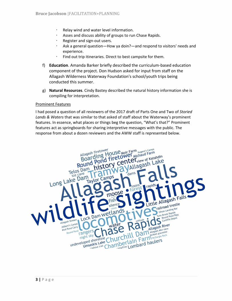
Prominent Features
I had posed a question of all reviewers of the 2017 draft of Parts One and Two of Storied Lands & Waters that was similar to that asked of staff about the Waterway’s prominent features. In essence, what places or things beg the question, “What’s that?” Prominent features act as springboards for sharing interpretive messages with the public. The response from about a dozen reviewers and the AWW staff is represented below.
Bruce Jacobson |FACILITATION+PLANNING
4 | P a g e
Curriculum Based Education
Amanda has been investigating curricula used in Aroostook and Piscataquis classrooms, and elsewhere in Maine. One notable finding is that integrating resources into cores class (science, English, math, social studies) is not practical due to existing materials mandated to be covered: teachers are simply overwhelmed and have no time for “extras.” This comports with our July 14 planning team discussion to propose resources that can be used to formally engages students in learning regardless of age or location (e.g., on the river, at schools, or in an adult ed course).
On August 30, I met with Kate Petrie, Supervisory Education Coordinator at Acadia National Park, to explore the ways the park interacts with teachers and schools in Hancock County. On August 31, Amanda and I met with Starr Kelly, Education Curator at the Abbe Museum. The Abbe has developed numerous education resources regarding the Wabanaki Nations in Maine.
Planning Process
The planning team is following a three step process: a) establish direction, b) assess background information, and c) develop the plan. While not strictly sequential, we are now moving into plan development. This autumn, as writing gets underway in earnest, we will establish a working group of individuals with expertise in interpretation, education, and the Allagash to provide input on the developing concepts.
a) Establish Direction. team formation and orientation. gather existing information. develop interpretive program goals
b) Assess Background Information. identify and profile target audiences. identify and evaluate factors affecting interpretation and education. inventory key tangibles and the stories that can be told using tangibles. write background sections.
c) Develop the Plan develop theme hierarchy for the interpretive program.
primary themes supporting/sub themes sample storylines
define desired visitor experiences. identify information networks necessary to support those experiences. identify delivery strategies (media) for communicating with target
audiences. prepare draft theme hierarchy, visitor experience, and information
network for review. prepare media descriptions. prepare cost range estimates. prepare action plan.

Interpretative Plan
for the Natural and Cultural Features of the Allagash Waterway
Although I have not officially begun the project, about a dozen people have identified key natural and cultural features
of the Waterway that might be subjects for interpretation, in response to a request I sent in May. (Please thank
members of the Advisory Council for sending along their thoughts, and encourage those who have not to do so.)On July
25, I'll meet with the Allagash Wilderness Waterway permanent and seasonal staff at Churchill Depot to continue
identifying key features, and to get a sense of the most frequent questions asked by visitors.
More generally, here is the text from page 7 of Storied Lands & Waters. It would be good to share this with Council
members on Friday.
"The planning team will begin by identifying how communication with Waterway users and other identified audiences
can be used to support the Waterway’s strategic and management plans (BPL, 2010, 2012). The purpose of interpretive
planning is to give managers tools to accomplish their goals and objectives. The team will develop interpretive goals and
objectives to address the identified management goals and objectives. Other planning activities will involve building
audience profiles and stating one or two overarching themes or messages to be communicated about the Waterway.
Sub-themes and storylines will flow from these “big picture” messages or themes. An inventory of interpretive
opportunities (features and objects) will inform creation of desired visitor experiences for the identified audiences. The
planning team will also identify actions to implement the recommended strategies (media), along with cost range
estimates.
“Interpretive planning generally leads from larger scale to smaller. The long-range plan will deal with the entire
Waterway, rather than an individual program or exhibit. The interpretive plan will be one of two needed interpretive
planning elements; the other is composed of implementation plans. Together they provide both large-scale/long-range
and focused/short-range approaches. [See Figure 2.] The long-range interpretive plan is primary because it lays out a
desired visitor experience for each target audience that addresses management objectives, and prescribes broad
implementation actions.
“The interpretive plan will include an education component to link Waterway interpretive goals and objectives with
compatible curricula of educators. Maine statute defines what school students are expected to know and be able to do
at each level of education for eight subject areas. The planning team will work with classroom educators to match
Waterway themes, sub-themes, and storylines to the statewide curriculum framework and relevant local curricula. The
planning team will also consult other educators who follow a curriculum, perhaps in outdoor education programs or
colleges and universities or community learning organizations.
"It is important to note that neither educating visitors nor simply sharing interesting facts is the purpose of Waterway
interpretation. Rather, the purpose is communicating with identified audiences in order to accomplish management
goals and objectives. Curricular planning, therefore, will identify ways to support education when it also helps
accomplish Waterway interpretive goals and objectives.”
From Bruce Jacobson