algonquin history in the ottawa river watershed 1 · ottawa river watershed 1 prepared by james...
TRANSCRIPT

This report was prepared based on the status or research to date; some observations and conclusions may1
change if and as new source materials are reviewed and incorporated.
Algonquin History in the
Ottawa River Watershed 1
Prepared by
James Morrison, Legal and Historical Research
261 rue Des Meurons
Winnipeg, Manitoba, R2H 2M9
Tel/fax: 204-233-7219
for
Peter Di Gangi
Sicani Research & Advisory Services
609 Redwood Avenue
Ottawa, Ontario, K2A 3E8
Tel: 613-722-3268
Fax: 613-724-7902
Revised 28 November, 2005

TABLE OF CONTENTS.
INTRODUCTION . . . . . . . . . . . . . . . . . . . . . . . . . . . . . . . . . . . . . . . . . . . . . . . . . . . . . . . . . . . . . 1
ALGONQUIN ORIGINS . . . . . . . . . . . . . . . . . . . . . . . . . . . . . . . . . . . . . . . . . . . . . . . . . . . . . . . . 3Wiskedjak pursues the Beaver . . . . . . . . . . . . . . . . . . . . . . . . . . . . . . . . . . . . . . . . . . . . . . 3
THE ALGONQUIN SENSE OF PLACE . . . . . . . . . . . . . . . . . . . . . . . . . . . . . . . . . . . . . . . . . . . 8
ALGONQUIN, FRENCH AND IROQUOIS . . . . . . . . . . . . . . . . . . . . . . . . . . . . . . . . . . . . . . . 14
ALGONQUIN PEOPLE IN THE EIGHTEENTH CENTURY . . . . . . . . . . . . . . . . . . . . . . . . . 23ALGONQUIN CALENDAR . . . . . . . . . . . . . . . . . . . . . . . . . . . . . . . . . . . . . . . . . . . . . . 32
ALGONQUIN PEOPLE IN THE NINETEENTH CENTURY . . . . . . . . . . . . . . . . . . . . . . . . . 34
There are also some communities on the Ontario side which assert Algonquin identity but are not2
recognized by the federal government. These include Beaverhouse, as well as a number of groups associated with theAlgonquins of Pikwakanagan land claims negotiations.
INTRODUCTION
The history of the Ottawa River watershed is inseparable from the history of the Algonquin
Nation. Though their territory was once considerably more extensive, the Algonquin heartland
has always included the entire length of the Ottawa River, from its headwaters in north-central
Quebec to its outlet near Montreal. At present, there are ten federally recognized Algonquin
communities, with a total population of approximately 8-10,000. Nine of the Algonquin2
communities are in Quebec. Proceeding from northwest to southeast, these are the Abitibiwinni,
Timiskaming, Eagle Village (Kebaouek), Wolf Lake, Long Point (Winneway), Kitcisakik (Grand
Lac), Lac Simon, Mitcikinabik Inik (Algonquins of Barriere Lake) and Kitigan Zibi (River
Desert) First Nations. In Ontario, members of the Algonquins of Pikwakanagan (at Golden
Lake) First Nation make up the only recognized Algonquin community, though three other
Ontario First Nation communities, Wahgoshig, Matachewan and Temagami, are of at least
partially Algonquin descent.
Compared to First Nations in most other parts of Canada, the ten Algonquin communities have
very little reserve land. By far the largest parcel is the River Desert Reserve belonging to the
Kitigan Zibi Algonquins. Consisting of approximately 43,000 acres, it is located near Maniwaki,
Quebec. The Timiskaming First Nation have a Reserve of approximately 5,000 acres at the head
of Lake Temiscamingue, Quebec, very close to the Ontario border. This Reserve, originally in
excess of 100,000 acres in size, was set apart by the Province of Canada in the period 1851-53, as
was the River Desert Reserve. The Golden Lake Reserve of the Algonquins of Pikwakanagan
Reserve at Golden Lake consists of approximately 1,750 acres near Renfrew, Ontario. The
Algonquins of Lac Simon occupy about 800 acres near Val D’Or, Quebec, and the Abitibiwinni
have about 225 acres near Amos, Quebec, as well as a joint share (with Wahgoshig First Nation)
of Abitibi Indian Reserve #70 near Matheson, Ontario. The Kebaouek (Eagle Village) First
Nation reside on a 53-acre parcel on Lake Kipawa, which was purchased from a third party and
Algonquin History in the Ottawa River Watershed.Draft for discussion only - Revised 28 November, 2005.
2
The Long Point First Nation occupies 91 acres of settlement lands at Winneway under a lease agreement3
involving the government of Quebec, the Oblates, and Canada. (Jacqueline Beaulieu, Localization of the Aboriginalnations in Quebec (Government of Quebec: Quebec, 1998): 34-35.
set apart as a Reserve in 1975, and the Mitcikinabik Inik (Algonquins of Barriere Lake) occupy a
59-acre reserve on Rapid Lake in the Réserve Faunique La Vérendrye, which was created in
1961. The Wolf Lake, Long Point and Kitcisakik First Nations have no reserve lands at all.3
The historical outline that follows does not purport to be exhaustive. It is only intended to
provide a broad picture of Algonquin history in the Kichisipi valley. In their own language,
Algonquin people call themselves anishinabeg, which carries both the general meaning of
“human being”, and the specific meaning of “real (i.e. Indian) people”. Though use of their
language, the anishinabemowin, has declined considerably in communities such as
Timiskaming, Kitigan Zibi and Pikwakanagan, it is still very much alive in interior
communities like Kitcisakik and Rapid Lake. Most Algonquin communities have inaugurated
programs to promote language retention or use.
Historically, the anishinabemowin was spoken very widely. Various dialects are still spoken
today not only by Algonquins, but by Ojibway (also known as Chippewa and Saulteaux),
Odawa (Ottawa) and Potawatomi people, among others. The fact that the language was so
widespread, however, has caused considerable confusion when interpreting historical records.
As will be seen below, although the First Nations of the Ottawa River watershed are today
called Algonquins, this is not necessarily how they were known in the three centuries
following contact with Europeans. Early French observers generally confined the term
Algommequin (Algonquin) to the various bands living along the lower Ottawa River drainage,
whose descendants now belong mainly to the Algonquins of Pikwakanagan (at Golden Lake)
and Kitigan Zibi (River Desert) First Nations. Those anishnabeg living in the upper Ottawa
valley and northeastward towards the headwaters of the river, by contrast, were known by
several different tribal and group names, including Nipissings, Timiskamings, Abitibis, Têtes de
Boules and gens des terres. By the end of the 17 century, however, as the French movedth

Algonquin History in the Ottawa River Watershed.Draft for discussion only - Revised 28 November, 2005.
3
further inland, they used the generic term Algonquin for all groups they encountered who spoke
the same language (ie., Ojibway, Potawatomi, etc.).
ALGONQUIN ORIGINS
Algonquin people believe they have always lived in the Ottawa valley, an understanding which is
reflected in their traditional stories. The anthropologist Frank Speck collected a number of these
Algonquin legends, including the following narrative about the pursuit of a giant beaver, when
carrying out fieldwork at Timiskaming Reserve in the summer of 1913.
Wiskedjak pursues the Beaver
Wiskedjak was travelling about looking for adventures. He never succeeded inanything he tried to do. He never did well and was always hungry. In his travelshe came to Kiwegoma “Turn-back-lake” (Dumoine lake). Now he even had nocanoe, but he was a great swimmer. When he came to Kiwegoma, he found iteven too big to swim, so he started to walk around it. He wanted to hunt beaver.On one side of the lake, he came to a round, high mountain that looked like abeaver-lodge. In front of it he found deep water, just as there is in front of abeaver lodge. And a little way off shore was a little island with many grasses; justas the beaver provides a winter supply of greens for himself near his lodge, so thisisland he supposed to be the beaver’s winter supply and the mountain his lodge. Wiskedjak wanted to get this great beaver, but did not know how to get at him. Then he thought of draining the lake, so he went way around to the lower end andbroke away the dam so that the water would run off. Soon the water began to go,and Wiskedjak lingered about, waiting for it to get low enough to get at thebeaver. Pretty soon he took a nap. When he woke up, it was rather late and hehurried back to the mountain only to find that the beaver had gone. Now hethought the beaver might have escaped over the dam with the water, so he startedback, and sure enough he saw the beaver going over the dam. “Now”, said he, “Ilost my beaver”. He followed hard after him and had lots of trouble to keep up.He followed him past Coulonge River and Pembroke Lakes. But when the beaverreached Calumet chutes, he was afraid to go through and took to the portage. ThenWiskedjak saw him and chased him harder over the portage. When he got to thelower end, he lost sight of the beaver and started back up river (Ottawa river).When he got to the upper end of the portage, he saw fresh tracks. “Well”, said he,“there has been somebody here. I wonder if I could trace him. We might havesomething to eat”. Then he followed the track to the lower end of the portage
Algonquin History in the Ottawa River Watershed.Draft for discussion only - Revised 28 November, 2005.
4
Frank G. Speck, “Myths and Folklore of the Timiskaming Algonquin and the Timagami Ojibwa”, Canada4
Department of Mines, Geological Survey, Memoir 71, No 9 Anthropological Series (Ottawa: Government PrintingBureau, 1915):1-3.
J.A. Cuoq, Lexique de la langue Algonquine (Montréal: J. Chapleau, 1886):442.5
where he had already been, but nobody was there. So he went back to the upperend of the portage and there saw more fresh tracks leading to the lower end. Thesehe followed to where he had been twice before, but saw no beaver. He thendiscovered that they were his own tracks he had been following and gave it up. The tracks back and forth can be seen plainly today imprinted on the stone ofCalumet portage, which the Indians call Wiskedjak tracks. 4
Dr Speck’s informant, Ben McKenzie, who had been raised as a member of the Kiwegoma
Anishnabeg or Dumoine Band (now the Wolf Lake First Nation), told Speck that he had learned
the stories from elders of that band when he was a young man. Since Ben McKenzie was born in
1847, his traditional education would have taken place in the 1860's.
Wiskedjak (Wisakedjak), also called Nenabojo (Nanabush), was the great culture hero of the
Anishnabeg. Often personified as the Canada Jay (still known popularly as the Whisky Jack),5
this trickster-transformer also features prominently in the legends of the neighbouring Cree and
Ojibway. Elders would tell these stories in cycles, generally in the wintertime, as a way of
providing the youth of the band with spiritual and moral direction. In the story above, Wiskedjak
drains Grand Lac Dumoine in order to hunt a giant beaver, whose lodge had taken the form of a
very large mountain. The French trader and explorer Nicolas Perrot (1644-1717) recorded an
analogous story in his memoirs, which he obtained from the Nipissing and the Amikwa (literally,
“beaver people”), both of them anishnabe-speaking groups living to the west of the Algonquins.
They told Perrot that a giant beaver (from whom the Amikwa claimed descent) had entered the
French River from Lake Huron, creating a series of dams as it travelled eastward through Lake
Nipissing and along the Ottawa River. These eventually turned into rapids and portages. The last
dam the beaver built became the Calumet rapids, at which point the beaver died, and was buried

Algonquin History in the Ottawa River Watershed.Draft for discussion only - Revised 28 November, 2005.
5
Nicolas Perrot, Mémoire sur les moeurs, coustumes et relligion des sauvages de l’Amérique6
septentrionale (Montréal: Comeau et Nadeau, 1999):36-37; Emma Helen Blair (ed), The Indian Tribes of the UpperMississippi Valley & Region of the Great Lakes, I (University of Nebraska Press, 1996):62-63.
P.F.X. de Charlevoix, Journal d’un voyage fait par l’ordre du roi dans l’Amérique septentrionale...7
(Paris, 1744):417-418.
to the north of Calumet Lake, in a mountain in the shape of a beaver. This would have been the6
mountain featured in Ben McKenzie’s story.
The Jesuit historian P. F.X. de Charlevoix, who travelled through the great lakes region in 1721,
tells a similar story about Amikwa origins, though he gives the great beaver’s final burial place
as a mountain on the north shore of Lake Nipissing. Charlevoix and Nicolas Perrot, as it turned7
out, had heard only the second half of the story. The first part, which the surveyor Robert Bell
collected in 1891 from Joseph Misabi, an Ojibway from the French River, directly links the story
Ben McKenzie told Frank Speck to the legend recounted by Nicolas Perrot two centuries earlier.
In ancient times, Joseph Misabi recounted to Bell, Kitchigami (Lake Superior) was the pond of
the great beaver, the Manitou Amik. His dam was at the outlet where the Sault Ste Marie rapids
(Bawating) now exist. Here he lived for many years until one day Nenabozho (Wiskedjak)
decided to hunt him. The cunning trickster sent his wife to the outlet to break the dam, which
would lower the water and, he hoped, frighten the great beaver into leaving his lodge. But the
beaver was too clever, and escaped before Nenabozho could find him. Angry at his wife for
failing to stop the beaver, Nenabozho kicked her through the air, which turned her into stone.
She landed on the north side of Lake Superior, forming the hill called Gros Cap. In the
meantime, the great beaver Manitou Amik hurried along the north channel of Lake Huron and
turned up the French River, tearing up the rocks through the back action of its feet and forming a
long series of dams, now rapids. He passed through Lake Nipissing and on down the Ottawa
River, ending up at the big island, where the Ottawa joins the great Noddaway River (the St

Algonquin History in the Ottawa River Watershed.Draft for discussion only - Revised 28 November, 2005.
6
“Nenabozhoo Hunts the Manitou-Amik”. Told to Robert Bell on French River in 1891 by Joseph Misabi. 8
NAC Robert Bell Papers MG29 B15 Vol 54 File 19.
Lawrence). Here he stopped and was turned to stone like his wife, forming a large hill (Montreal
Mountain). 8
This story can be interpreted in a number of ways. On one level, it can be taken as a myth of
national origins. Though the beaver’s final resting place varies, the sites all fall within the
historic range of the eastern anishnabeg, basically between the north shore of Lake Huron and
Montreal. But there is a core of even deeper historical truth to the legend. Giant beavers, along
with many other now-extinct megafauna, inhabited North America between 10 and 12,000 years
ago. Their remains have been found in various locations, including Ontario. Moreover, the story
of the trickster-transformer draining Lake Superior or Dumoine Lake in pursuit of the beaver,
who then creates rapids and portages as it flees to the east, evokes the natural history of the great
lakes basin and the Ottawa River watershed in the aftermath of the last great ice age.
With the retreat of the Wisconsin glacier, an enormous glacial lake (which geologists have
dubbed Agassiz) covered virtually all of Manitoba, and parts of Saskatchewan, North Dakota,
Minnesota and Ontario for much of the period between 15,000 and 8,000 years ago. This lake
first drained southward into the Mississippi, then southeastward into what became the Lake
Superior basin, and finally due eastward into another glacial lake called Barlow-Ojibway, which
covered present northeastern Ontario and northwestern Quebec. The remains of the northern
glacier, however, prevented Lake Barlow-Ojibway from draining into James Bay, and a great
mass of glacial debris blocked the southward flow of water into what is now the Ottawa River.
Over a period of about two thousand years, the northern ice gradually melted. The waters of
Lake Barlow-Ojibway eventually cut through the debris blocking the flow to the south and about
8,000 years ago, the whole lake abruptly (in geological terms) emptied into James Bay. Further
to the east, when the vast Laurentide ice sheet began retreating from the Ottawa valley, also
about 15,000 years ago, the valley was immediately flooded by salt waters from the Atlantic
Ocean, forming an inland sea. There was a rich diversity of marine life within this Champlain

Algonquin History in the Ottawa River Watershed.Draft for discussion only - Revised 28 November, 2005.
7
Much of the information in this paragraph is taken from brief archaeological summaries prepared for the9
Ottawa River Heritage Designation Committee by John Pollock of Settlement Surveys Ltd in New Liskeard, andJean-Luc Pilon, Curator of Ontario Archaeology at the Canadian Museum of Civilization
Sea (as geologists named it), including some of the largest mammals on earth, such as the
Bowhead Whale (the skeleton of one was found at Pembroke in the 1970s). The earth’s crust
eventually adjusted to the immense weight of the glacier and the sea drained, a process which
ended about 10,000 years ago, being replaced for a few more thousand years by an enlarged, but
gradually reducing, version of the Ottawa River, fed by fresh water from glacial lakes Agassiz
and Barlow-Ojibway. It was during this period between 10,000 and 8,000 years ago that the first
tangible signs of human occupation appear in what is now the Ottawa River watershed. Though
the archaeological evidence is often very difficult to find (because of the problem in identifying
the original shoreline of the Champlain Sea and Lake Barlow-Ojibway), it appears that mobile
groups of hunter/gatherers entered the region and began exploiting the available resources, which
would have included animal species like caribou and beaver. It may in fact be this ancient
history of the draining of lakes and the emergence of rivers that is recorded in myths like Ben
McKenzie’s story of Wiskedjak and the giant beaver. 9
For the period beginning about six thousand years ago, the evidence of human occupation is
much more abundant. For example, archaeological excavations carried out for many years on
Allumette Island and nearby Morrison Island by the late amateur archaeologist Clyde Kennedy
(and others) have turned up an enormous variety of artifacts, which include stone and bone tools
as well as native copper implements originating on Lake Superior. The people who inhabited
these sites appear to have followed a seasonal round of hunting, fishing and gathering, and they
were clearly integrated into long-distance trading networks. In addition to Lake Superior copper,
the materials they were using to manufacture tools included quartzite from Manitoulin Island and
Vermont, and chert from various locations between the north shore of Lake Ontario and the
southern shores of Lake Huron. Though archaeologists are reluctant to speculate about ethnic
continuity, the lifestyle of these Shield Archaic people was remarkably similar to that of the

Algonquin History in the Ottawa River Watershed.Draft for discussion only - Revised 28 November, 2005.
8
See the various articles in Normant Clermont, Claude Chapdeleine et Jacques Cinq-Mars (eds), Ile aux10
Allumettes: L’Archaïque supérieur dans l’Outaouais. Collection Paléo-Québec (Recherches amérindiennes auQuébec et Musée Canadien des civilizations, 2003).
Frank G. Speck, “Myths and Folklore of the Timiskaming Algonquin and the Timagami Ojibwa”, Canada11
Department of Mines, Geological Survey, Memoir 71, No 9 Anthropological Series (Ottawa: Government PrintingBureau, 1915):1-3; J.A. Cuoq, Lexique de la langue Algonquine (Montréal: J. Chapleau, 1886):371.
The Algonquin terms irini (now “inini”) and anishnabeg are synonyms. Both are still in use today. The12
Timiskaming Algonquins call themselves Saugeen Anishnabeg while the Algonquins of Barriere Lake callthemselves Mitcikinabik inik.
Algonquins encountered by the first Europeans. When coupled with the oral history, there is little
reason to suppose they are not the same people. 10
THE ALGONQUIN SENSE OF PLACE
As the anthropologist Frank Speck discovered when collecting Algonquin legends, Wiskedjak’s
adventures are always located within the territory of the band whose member is telling the story.
In Ben McKenzie’s story of the giant beaver, he refers specifically to the Dumoine and Coulonge
Rivers, “Pembroke lakes” (i.e. lower and upper Allumette lakes), and the Calumet chutes or
rapids. The larger river down which Wiskedjak finally proceeds, says Dr Speck, was the Kichi
sipi., literally “big river”. This has always been the Algonquin name for the Ottawa River, an11
obvious reference to its length and breadth. Samuel de Champlain and other early French
explorers identified the band who occupied the immediate vicinity of the Allumette lakes and
Calumet portage, and whose summer village on Morrison Island Champlain visited in 1613, as
the Kichesipirini (Kichi sipi irini), literally “big river people”. Exactly three centuries later,
Frank Speck was told that the bands living along the Ottawa were still known as the Kichi sipi
anishnabeg, “big river people”. The Algonquin name of the river has survived (in translation)12
as “Grand River” or “Grande Rivière”, a term first recorded by the Sulpicians Dollier de Casson
and Bréhant de Galinée on the map legend illustrating their 1669-70 voyage of discovery through

Algonquin History in the Ottawa River Watershed.Draft for discussion only - Revised 28 November, 2005.
9
James H Coyne (ed), “Galinée’s Narrative and Map (1669-70)”, Ontario Historical Society: Papers and13
Records, Vol IV (Toronto: The Ontario Historical Society, 1903):78-79 (map);86-87 (#55).
part of the great lakes. That particular name for the river was still in common use among13
European traders and settlers in the eighteenth and nineteenth centuries.
The Ottawa River takes its rise about 250 kilometers north of the present cities of Ottawa and
Gatineau in Lac Capimichigama, also known as Lac Travers or Cross Lake (its full anishnabe
meaning is “crossing from one watershed to another”). From Capimichigama, which is within
the traditional territory of the Algonquins of Barriere Lake, the Ottawa flows westward, then
southward, then southeastward for about 1200 kilometers, before joining the St Lawrence River
near Montreal. Unlike modern geographers, however, Algonquin people never used the same
name for an entire watershed. They confined the term Kichi sipi to the lower part of the river,
from Matawang, now Mattawa (which means “where the river divides”), down to Lake of Two
Mountains. The uppermost sections of what is now called the Ottawa, which are really a
continuous series of linked river expansions, had many different names. The best known of these
upper sections is Temiskaming Sagahigan, literally “deep water lake”, which forms part of the
current boundary between Ontario and Quebec. But even that name applied only to the
northernmost, and widest, portion of present Lake Temiscamingue. The section below the
narrows was known, appropriately enough, as obawjewanong Sagahigan, or “narrowed-current
lake”. That part of the same river flowing from modern Lac des Quinzes into the head of Lake
Temiscamingue (called the Quinze River in Quebec) was known as wanaweia sipi or “dirty
water river”. Algonquin names for other prominent sections of the watershed include Kichi Saki
or “big-outlet” (for Grand Lac Victoria), and Mitcikinabikong, or “place of the stone fence or
weir”, which was translated directly into French as Lac Barrière.
Apart from Mattawa, almost none of the Algonquin place names on the lower Ottawa have
survived in common usage. Instead, for over three hundred years, names such as the Long Sault,
Chaudière, Lac des Chats, Calumet, Allumettes, Des Joachims and Dumoine have reflected the
Algonquin History in the Ottawa River Watershed.Draft for discussion only - Revised 28 November, 2005.
10
H.P. Biggar (ed), The Works of Samuel de Champlain, Vol II (Toronto: The Champlain Society,14
1925):261.
J.A. Cuoq, Lexique de la langue Algonquine (Montréal: J. Chapleau, 1886):169.15
H.P. Biggar (ed), The Works of Samuel de Champlain, Vol II (Toronto: The Champlain Society,16
1925):268. The word Asticou must be a misprint in the original text, because the Algonquin word for small cauldronsor boilers (plural) is Akikok. The missionary JA Cuoq says that the full name for the Chaudière Falls is Akikodjiwan, which means “place where the water falls into stone basins whose rounded form resembles a boiler”.J.A. Cuoq, Lexique de la langue Algonquine (Montréal: J. Chapleau, 1886):31.
long history of French exploration and trade in the valley. Some of these place names, like Des
Joachims and Dumoine, are obviously of European origin. The original Algonquin name of the
Dumoine River (still used by elders of the Wolf Lake and Eagle Village First Nations) is
aginagwasi sipi. As with Lake Barrière, however, many other French toponyms turn out to be
literal translations of their original Algonquin names. This process dates back to the very
beginning of upriver exploration, as evidenced by the writings of Samuel de Champlain, the first
European to record the features of what he called the “Rivière des Algommequins” or
Algonquin River. On 31 May 1613, after paddling through what is now the Lake of Two
Mountains, Champlain and his companions “passed a rapid which is called by the inhabitants
Quenechouan. It is full of stones and rocks, and the water flows through them with great
swiftness”. The word Quenechouan (Kinodjiwan) means “long rapid” in Algonquin, and this14
20 kilometre stretch of the river (eventually submerged by the Carillon and Grenville canals)
was known ever after as the Long Sault. 15
On 4 June 1613, Champlain came across a wide deep basin where “the water whirls around to
such an extent, and in the middle sends up such big swirls, that the Indians call it Asticou,
which means ‘boiler’”. He dubbed this feature the “Sault de la Chaudière”, a name which16
still applies to the famous rapids between the cities of Ottawa and Gatineau. Champlain also
described the traditional ceremony which he witnessed at the falls on his return journey a week
later, as performed by the Algonquin canoe party which was accompanying him back to
Quebec:

Algonquin History in the Ottawa River Watershed.Draft for discussion only - Revised 28 November, 2005.
11
H.P. Biggar (ed), The Works of Samuel de Champlain, Vol II (Toronto: The Champlain Society,17
1925):303.
Frank G. Speck, “Myths and Folklore of the Timiskaming Algonquin and the Timagami Ojibwa”, Canada18
Department of Mines, Geological Survey, Memoir 71, No 9 Anthropological Series (Ottawa: Government PrintingBureau, 1915):2.
G.D. Scull (ed), Voyages of Pierre Esprit Radisson (Boston: The Prince Society, 1885):163.19
J.A. Cuoq, Lexique de la langue Algonquine (Montréal: J. Chapleau, 1886):308.20
Having carried their canoes to the foot of the fall, they assemble in one place,
where one of them takes up a collection with a wooden plate into which each
puts a piece of tobacco. After the collection, the plate is set down in the middle
of the group and all dance about it, singing after their fashion. Then one of the
chiefs makes a speech, pointing out for years they have been accustomed to
make such an offering, and that thereby they receive protection from their
enemies; that otherwise misfortune would happen to them, as the devil
persuades them [...] When he has finished, the orator takes the plate and throws
the tobacco into the middle of the boiling water, and all together utter a loud
whoop.17
Shortly before arriving at the village of the Kichi Sipi Algonquins, Champlain passed a set of
dangerous rapids, which are identified on the map of his travels as the “sault des Calumets”,
also described as “the Calumet stone rapids, which are like alabaster”. This too is a translation
of an Algonquin term, Opwagani pawatik or “pipe rapids”. The stone at that place, so Ben
McKenzie told Dr Frank Speck in 1913, was “suitable for making pipes and was there sought
by the Indians for that purpose”. The trader and explorer Pierre Esprit Radisson had made the18
same observation in the summer of 1660. The Calumet rapids, he said, were “so called because
of the stones that are there very convenient to make tobacco pipes”. In the anishnabe19
language, both tobacco (n’asema) and the calumet or pipe (opwagan) are animate objects,
which reflects their centrality in the culture of the Algonquins (and other North American
tribes). Tobacco was always an important part of Algonquin ceremonies, as Champlain had
observed at the Chaudière Falls, and all feasts, funerals, games and councils of peace or war
involved the ritual smoking of the calumet. Champlain took part in one such ceremony when20
meeting with Chief Tessouat and the Kichisipirini at Morrison Island. Algonquin people also
used the pipe as a measure of time and distance, a custom they passed on to French-Canadian
Algonquin History in the Ottawa River Watershed.Draft for discussion only - Revised 28 November, 2005.
12
J.A. Cuoq, “Anotc Kekon”, Mémoires de la Société Royale du Canada, Section I (1893):142; G.M.21
Grant, Picturesque Canada (Toronto: Belden, 1882):77.
G.D. Scull (ed), Voyages of Pierre Esprit Radisson (Boston: The Prince Society, 1885):163. The original22
manuscript of Radisson’s voyages has never been found, so the work exists only in English translation. Radisson’swriting must have been hard to read, because the original translator mistranscribes several tribal names, renderingAmikwa as “Amickoick”, Ottawak as “Ottanak”, Ottawasinago as “Nadonicenago”, Kiskakon as “ticacon” andNassawaketon as “panoestigon”.
Johanna E. Feest and Christian F. Feest, “Ottawa”, in Handbook of North American Indians, Volume 15:23
Northeast, Bruce Trigger, ed (Washington: Smithsonian Institution, 1978):776-777.
G.M Wrong (ed), Sagard’s Long Journey to the Country of the Hurons (Toronto: The Champlain24
Society, 1939):66. Linguist Pierrette Lagard argues that “ondataouaouat” means “folded plaits” in Huron. LucienCampeau, La Mission des Jésuites chez les Hurons 1634-1650 (Montréal: Bellarmin, 1987):430.
H.P. Biggar (ed), The Works of Samuel de Champlain, Vol III (Toronto: The Champlain Society,25
1929):43.
settlers and voyageurs. Thus, the word Nijopwagan (“deux pipes”) meant the time it took to
smoke two pipes, which was approximately an hour. 21
It might seem strange that the Kichi sipi, or “great river of the Algonquins”, is now known as
the Ottawa River. But use of the latter name can be traced to the later seventeenth century.
When Pierre Radisson passed the Calumet rapids in 1660, he was travelling with a large
flotilla of canoes from the upper great lakes who were going down to Montreal to trade. Most
were “Ottawak” (as Radisson called them) and other closely related groups. In the seventeenth22
century, the Odawa (Ottawa) occupied the arc of land between eastern Lake Huron, the Bruce
Peninsula, the Manitoulin Island chain and the Straits of Mackinac. There are still large numbers
of Odawa people living on Manitoulin Island and in northern Michigan to this day. It has23
generally been argued (following the Recollet missionary Gabriel Sagard) that the word Odawa
(Ottawa) is a contraction of the Huron word Ondatawwat, meaning “Cheveux Relevés” or
“raised hairs”. Samuel de Champlain met three hundred members of a nation he called the24
“Cheveux Relevés” on his second trip inland in the summer of 1615. They were gathering
blueberries near the mouth of the French River. However, it is also possible that Odawa is25

Algonquin History in the Ottawa River Watershed.Draft for discussion only - Revised 28 November, 2005.
13
J.A. Cuoq, Lexique de la langue Algonquine (Montréal: J. Chapleau, 1886):65.26
H.P. Biggar (ed), The Works of Samuel de Champlain, Vol VI (Toronto: The Champlain Society,27
1936):246-47.
Nicolas Perrot, Mémoire sur les moeurs, coustumes et relligion des sauvages de l’Amérique28
septentrionale (Montréal: Comeau et Nadeau, 1999):115-144.
“”Qu’on continue donc à écrire Ottawa, comme on prononce, and non pas Outaouais, comme on ne29
prononce pas, et comme on n’a jamais prononcé”. J.A. Cuoq, Lexique de la langue Algonquine (Montréal: J.Chapleau, 1886):311. The source of the error was the substitution of “ou” for the vowel sound written as “8" (as in“huit”) in early French orthography of the word 8ta8ois. The English “w” is much closer to the actual sound.
derived from atawe, the anishnabe word for trader. According to Champlain and later26
observers, trading was an important part of the “Cheveux Relevez” way of life:
The Cheveux Relevez are Indians who wear no breech-cloths and go naked,
except that in winter they clothe themselves in fur robes, which they take off
when leaving their homes to go about the country. They are great hunters,
fishermen, and travellers, they cultivate the land and sow Indian corn, dry
blueberries and raspberries, in which they do a great trade with other people,
from whom they take furs, wampum, nets and other commodities in exchange.27
Whatever the origin of their name, the Odawa lived on Lake Huron, not in the Ottawa valley. It
was their predominant role as middlemen in the fur trade in the second half of the seventeenth
century, not their place of residence, that led Montreal traders and government officials to start
calling the Algonquin River the River of the Odawa. The trader Nicolas Perrot, who came to
Canada in 1660, and spent much of his career in the upper great lakes, uses the latter term
consistently in his memoirs, and he was joined by other French historians and mapmakers. It28
should be pointed out, however, that the English spelling “Ottawa” is much closer to the
original Indian usage than its current French equivalent. As the nineteenth-century missionary
linguist J.A. Cuoq explains, the word Odawa was never pronounced “Outaouais”.29
Algonquin History in the Ottawa River Watershed.Draft for discussion only - Revised 28 November, 2005.
14
H.P. Biggar, The Early Trading Companies of New France: A Contribution to the History of Commerce30
and Discovery in North America, reprint of 1901 edition (New York: Argonaut Press, 1965):47.
Gordon Day, "The Name 'Algonquin'", International Journal of American Linguistics 38(4) (1972):226-31
228.
Lucien Campeau SJ (ed), Monumenta Novae Franciae, Vol IV: Les grandes épreuves (1638-1640)32
(Montréal: Bellarmin, 1989):39*-40*; 47*.
ALGONQUIN, FRENCH AND IROQUOIS
Samuel de Champlain first encountered Algommequins (Algonquins) in 1603 at Tadoussac,
where they and their Montagnais and Etchemin (Maliseet) allies were celebrating a victory over
their traditional enemies, the Five Nations Iroquois. For the Algonquins, this was certainly not
their first meeting with the people they called Wemitigojiwak ( “wooden ships”). They had
already been trading with the French at Tadoussac for several years, and may well have had
earlier encounters with Basque and Breton fishermen who had been active in the St Lawrence
estuary for some two hundred years. The exact origin of the word Algonquin is unclear, but30
it seems to have been a name applied by outsiders. One suggestion is that it derives from the
Maliseet term elakomwik, meaning "they are our relatives (or allies)". Champlain and early31
missionaries like the Recollets and Jesuits applied the name most commonly to a number of
anishnabe-speaking bands then living in the lower Ottawa valley, who appear to have
functioned as a trade and military alliance. The largest of these groups were the Kichesipirini
or "Big River people", who had their main village on Morrison Island, and who probably
consisted of more than one traditional band. Other related bands included the Waweskarini
(literally wawashkesh irini or "deer people"), also known as the "Petite Nation des
Algonquins", whose traditional lands were along the Rouge, Petite Nation and Lièvre Rivers
immediately west of Montreal; the Matouweskarini (“Madawaska people”), whose territory lay
along the river of that name, which flows into the Ottawa near modern Arnprior; the
Kinouchebiriiniouek (Kinozhe sipi iriniwag or “Pike river people”), who probably inhabited the
Bonnechere River drainage near Renfrew; and the Onontchataronon, also known as the people
of Iroquet, after one of their chiefs, who lived along the South Nation River in what is now
eastern Ontario.32

Algonquin History in the Ottawa River Watershed.Draft for discussion only - Revised 28 November, 2005.
15
Lucien Campeau SJ (ed), Monumenta Novae Franciae, Vol IV: Les grandes épreuves (1638-1640)33
(Montréal: Bellarmin, 1989):33*; H.P. Biggar (ed), The Works of Samuel de Champlain, Vol II (Toronto: TheChamplain Society, 1925):284.
H.P. Biggar (ed), The Works of Samuel de Champlain, Vol III (Toronto: The Champlain Society,34
1929):37-39.
It has recently been suggested that these people were ancestral to the modern Algonquins of Kitcisakik35
(Grand Lac), though that doesn’t seem to fit with Champlain’s territorial description. Roland Chamberland et al,Terra incognita des Kotakoutouemis. L’Algonquinie orientale au XVIIe siècle (Les Presses de l’Université Laval,2004).
The territory of these lower Algonquin bands extended no further up the Ottawa than Deep
River. Their nearest neighbours to the west were the Nipisiriniens (Nipising irini), another
group of related bands who had their main summer village on the north side of Lake Nipissing
(which Champlain visited in 1615) and whose territories extended over a considerable area in
all directions from that lake, including parts of northeastern Georgian Bay, the Mattawa River
drainage, and adjacent portions of the Ottawa River watershed. The southernmost winter
encampments of the Nipisiriniens or Nipissings were close to the villages of the Iroquois-
speaking Huron Confederacy in modern Simcoe County. Famed for their religious prowess
(the Huron called them “sorciers”), the Nipissings operated an extensive trading network in
conjunction with their Huron allies. The Jesuits often classed them as Algonquin because they
spoke that language, but until the mid-seventeenth century, they were not always on the best of
terms with anishnabe neighbours such as the Kichesipirini. 33
There were other bands living to the north, whose existence the early Europeans were only
dimly aware of, and who may or may not have been part of the Algonquin alliance. Champlain
was told of a group called the Otaguotouemins (Kotakoutouemi) whose territory extended
inland from the rugged country between Deep River and Mattawa, and who seldom came out
to the main river. The derivation of that name is obscure, but the same territory was occupied34
in the nineteenth century by what is now the Wolf Lake (formerly Dumoine) First Nation. 35
And the Jesuit Relation for 1640, drawing on the lost memoirs of the interpreter and trader
Jean Nicolet de Belleborne (who spent the 1620's among the Nipissings), mentions several
Algonquin History in the Ottawa River Watershed.Draft for discussion only - Revised 28 November, 2005.
16
Lucien Campeau SJ (ed), Monumenta Novae Franciae, Vol IV: Les grandes épreuves (1638-1640)36
(Montréal: Bellarmin, 1989):38*-39*.
H.P. Biggar (ed), The Works of Samuel de Champlain, Vol VI (Toronto: The Champlain Society,37
1936):243#81; Lucien Campeau SJ (ed), Monumenta Novae Franciae, Vol III: Fondation de la Mission Huronne(1635-1637) (Québec: Les Presses de l’Université Laval, 1987): Doc 64, Relation de 1636, p.330.
Lucien Campeau SJ (ed), Monumenta Novae Franciae, Vol III: Fondation de la Mission Huronne38
(1635-1637) (Québec: Les Presses de l’Université Laval, 1987): Doc 64, Relation de 1636, p.297.
Diane Daviault, L’Algonquin au XVIIe siècle: une édition critique, analysée et commentée de la39
grammaire algonquine du Père Louis Nicolas (Sainte-Foy: les Presses de l’Université du Québec, 1994):531): 33[8]; 531.
additional groups, among them the Timiscimi (Timiskamings) and Outimagami (Temagami). 36
But early eyewitness accounts of these and other groups are lacking because, other than Nicolet
and perhaps one or two others, no French people travelled on the upper Ottawa north of
Mattawa prior to 1670.
Apart from Champlain’s voyages, details of the Algonquin way of life in the first half of the
seventeenth century are surprisingly rare. Even though Jesuit and Recollet missionaries
travelled through the southern parts of Algonquin territory over the following years on their
way to and from Huronia, they left little information about the inhabitants. The names of some
of the bands (“Big River people”, “Madawaska River people”) suggest that Algonquin
territorial organization was based on watersheds, which was certainly the case two hundred
years later. The bands also maintained their boundaries zealously. As Champlain and others
noted, the Kichisipirini levied tolls on the Hurons, Nipissings, and any other groups passing up
and down the river by Allumette Island. So too did the Nipissings within their own37
territories. Each band had one or more “Captains”, a word the French translated literally38
from the anishnabe word Okima, meaning Chief. While these chiefs were chosen for their39
leadership abilities (and usually for their spiritual powers), the bands were not organized
hierarchically (unlike European societies). Chiefs could not coerce members to do their

Algonquin History in the Ottawa River Watershed.Draft for discussion only - Revised 28 November, 2005.
17
Lucien Campeau SJ (ed), Monumenta Novae Franciae, Vol II: Établissement à Québec (1616-1634)40
(Québec: Les Presses de l’Université Laval, 1979): 69*-70*.
H.P. Biggar (ed), The Works of Samuel de Champlain, Vol II (Toronto: The Champlain Society,41
1925):275; Vol VI (Toronto: The Champlain Society, 1936):251-52.
H.P. Biggar (ed), The Works of Samuel de Champlain, Vol II (Toronto: The Champlain Society,42
1925):275-80.
H.P. Biggar (ed), The Works of Samuel de Champlain, Vol III (Toronto: The Champlain Society,43
1929):52-53.
bidding, and what powers they had were only exercised during the summer gathering period,
when the various families came together to take part in communal activities. 40
Though the Algonquins were sometimes described as nomadic, this was only by comparison
with the more sedentary Iroquois and Huron. Generally speaking, families remained within
their band’s territory, following a seasonal round of resource harvesting activities. During the
winter, they lived in the bush in extended families, hunting large game like moose and deer,
and trapping fur-bearing animals, particularly beaver, which was valued both for its pelt and
flesh. Though fishing took place year-round, it was most productive between spring and fall.
Champlain mentioned that Muskrat Lake (near Cobden) was an important fishery for all the
people in the surrounding area, and that the Nipissings took great quantities of sturgeon, pike
and carp, some of them of enormous size, from both their lake and the (aptly-named) Sturgeon
River. The Nipissings and the Algonquin bands along the lower Ottawa also practised a form41
of slash and burn agriculture. Champlain saw cornfields at Muskrat Lake and peas, beans and
squash, as well as corn, growing on Allumette Island. However, he noted that the soil was
relatively poor, and that the Algonquins, unlike the Hurons, relied more on hunting than on
tilling the soil. 42
Living as they did on a major water route between the Atlantic coast and the interior of North
America, the Nipissings and Algonquins were intimately involved in inter-tribal trade. Their
closest economic relations were with the Hurons, who traded corn and cornmeal, wampum and
fish nets with both the Nipissings and Algonquins in exchange for furs and dried fish. The43

Algonquin History in the Ottawa River Watershed.Draft for discussion only - Revised 28 November, 2005.
18
R.G.Thwaites (ed), The Jesuit Relations and Allied Documents, Vol 24, Relation of 1642-4344
(Cleveland:Burrows Brothers, 1898):220-221;266-270.
Nipissings and Algonquins in turn secured pelts (in addition to their own fur harvest) from
Ojibway, Cree and other people living as far away as Lake Superior and James Bay. It was along
these existing trade routes, using the same transportation systems, that European goods first made
their way inland. In the later part of the century, French traders came inland themselves. But
they discovered (as Champlain had earlier found out) that in order to do business, they had to
follow Indian customs. This meant treaties of peace and military alliance, because only friends
could trade.
Over the course of the seventeenth century, many of these Algonquin bands were considerably
affected both by European diseases (particularly smallpox), and by ongoing warfare with the
Five Nations Iroquois, who were gaining a military advantage by obtaining firearms from
Dutch and English colonists on the Atlantic coast. Every summer, marauding canoe parties of
Matchi Nottaway (“bad Snakes”, as the Algonquins called the Iroquois) would harass people,
both native and European, living on or near the Ottawa and St Lawrence Rivers. As a result,
some of the lower Algonquins, particularly the Matouweskarini, the Onontchataronons and the
Kichesipirini, whose hunting grounds lay directly along the Iroquois warpath, began spending
their summers at Trois Rivières, or at the new French settlement of Ville Marie on Montréal
Island (founded in 1642), though they still returned upriver in the wintertime. The upper44
Ottawa valley between Deep River and Lake Temiscamingue also became increasingly unsafe.
By 1650, the Iroquois had destroyed the Huron Confederacy and were launching attacks on the
Nipissings, who sought temporary safety in the interior, some of them fleeing along their
habitual trade routes as far as northern Lake Superior. Other Nipissings and Algonquins,
however, remained in their traditional territories. They simply avoided the lower Ottawa in the
summer, instead using a parallel route to Trois Rivières and Montreal that took them along the
Algonquin History in the Ottawa River Watershed.Draft for discussion only - Revised 28 November, 2005.
19
R.G.Thwaites (ed), The Jesuit Relations and Allied Documents, Vol 44, Relation of 1657-5845
(Cleveland:Burrows Brothers, 1899):234-244.
Frank G. Speck, “Myths and Folklore of the Timiskaming Algonquin and the Timagami Ojibwa”, Canada46
Department of Mines, Geological Survey, Memoir 71, No 9 Anthropological Series (Ottawa: Government PrintingBureau, 1915):76-78; RN 10680. D.S. Davidson, “Folktales from Grand Lake Victoria, Quebec”, The Journal ofAmerican Folklore, Vol 41 No 160 (April-June 1928):280-281; Survey Report 1892-93, in The Ottawa Region.Description of surveyed townships, exploration of territories and scaling of rivers from 1890 to 1908. (Quebec Deptof Lands and Forests, 1908): pp.170-71.
James H Coyne (ed), “Galinée’s Narrative and Map (1669-70)”, Ontario Historical Society: Papers and47
Records, Vol IV (Toronto: The Ontario Historical Society, 1903):10-11.
Dollier de Casson, Histoire du Montreal, in Mémoires de la Societe Historique de Montreal (Montréal:48
La Minerve, 1868):76.
upper Ottawa from the north end of Lake Temiscamingue and across to the headwaters of the
Lièvre and St Maurice Rivers.45
The modern Algonquins of Kitcisakik and other interior communities have retained oral history
about the Iroquois attacks, but such raids must have been relatively rare. In contrast to the46
Hurons, whose year-round villages were easy targets for the Iroquois, Algonquin people only
came together in sizeable numbers in the summertime. Except for vulnerable sites like
Allumette Island and the mouth of the Sturgeon River on Lake Nipissing, most Algonquin
villages would have been difficult to reach. The Iroquois used heavy elm canoes which were
really only suitable for major waterways like the lower Ottawa, unlike the lightweight bark
canoes of the anishnabeg, which were adapted to the difficult rivers of the Shield. Moreover,47
the Iroquois hardly ever raided north of the Ottawa or St Lawrence in the winter, because
subsistence was so difficult. As the seventeenth-century Sulpician historian Dollier de Casson
pointed out, game was scarcer in these regions than in their own country, and the Iroquois were
poor fishermen.48
Throughout the latter half of the century, there were several truces or interludes of peace
(accompanied by a profitable trade in furs), interrupted by frequent outbreaks of war. Though
the Five Nations had better access to firearms, the conflict was not all one-sided. By the mid-
1660's, French, Algonquin, Nipissing, Huron and Abenaki warriors were carrying the war to
Algonquin History in the Ottawa River Watershed.Draft for discussion only - Revised 28 November, 2005.
20
The best recent discussion of events in this period is in Allan Greer, Mohawk Saint: Catherine49
Tekakwitha and the Jesuits (Oxford University Press, 2005):89-110.
the main Iroquois villages in the Finger Lakes region of present upstate New York. In 1666,
they captured and burned all the villages of the Mohawks, the easternmost of the Five Nations.
The ensuing peace treaty in 1667 would limit Iroquois attacks for more than a decade. In the
years that followed, the Iroquois took advantage of the peace to establish a series of villages
along the north shore of Lake Ontario between modern Toronto and Gananoque, which made it
easier for them to trade with the French settlements on the St Lawrence. This general
northward movement, however, had unintended consequences. One of the conditions of the
Treaty had required the Iroquois Confederacy to allow Jesuit missionaries into their villages.
The result was a net population loss, particularly for the Mohawks, because the Jesuits
eventually persuaded most of their converts to relocate to the Montreal region. Many of the
new arrivals, who the Algonquins and Nipissings called niina Nottaway or “our Snakes”
(which was also their name for the Hurons) settled at the Jesuit mission of Kentake or La
Prairie on the south shore of the St Lawrence, which was moved somewhat later to what is
now Kahnawake. By the mid-1670's, other Iroquois had joined a Sulpician mission to the
Christian Hurons and Algonquins, located at what is now the intersection of Atwater and
Sherbrooke Streets at the foot of "La Montagne" or Mount Royal (Kanasetake in Iroquois).
Though these new arrivals were now French allies, they maintained close connections to their
original villages (so much so that the French would later accuse them of carrying on
contraband trade with the Dutch and English). 49
During the peaceful decade, French influence expanded enormously in the North American
interior. French traders and missionaries flooded into the pays d’en haut or “upper country”
(basically the area between the Ohio valley and the upper great lakes) and large trading parties
from the interior Nations made annual summer visits to Montreal by way of the great lakes and
the Ottawa or St Lawrence Rivers. By 1673, there were Jesuit missions at Sault Ste Marie and
Michilimackinac and French trading posts as far north as Piscotagemy (Nighthawk) Lake, near
modern Timmins, Ontario. Angry at French expansion, however, and urged on by the English
Algonquin History in the Ottawa River Watershed.Draft for discussion only - Revised 28 November, 2005.
21
Francis Jennings, The Ambiguous Iroquois Empire: The Covenant Chain Confederation of Indian Tribes50
with English Colonies from its beginnings to the Lancaster Treaty of 1744 (New York: WW Norton, 1984): 172-185.
Gouverneur La Barre au roi, 4 oct 1682; La Barre au Marquis de Seignelay, 12 nov 1682. In Pauline51
Dubé (ed), La Nouvelle France sous Joseph-Antoine Le Febvre de la Barre 1682-1685: Lettres, Mémoires,Instructions et Ordonnances (Québec: Septentrion, 1993): 46-47; 55-64.
Revue faite au fort Frontenac le 17 aoust 1684 des sauvages qui nous ont suivis pour la Guerre, par M. le52
Fevbre de la Barre. In Pauline Dubé (ed), La Nouvelle France sous Joseph-Antoine Le Febvre de la Barre 1682-1685: Lettres, Mémoires, Instructions et Ordonnances (Québec: Septentrion, 1993): 219.
W.A. Kenyon & J.R. Turnbull, The Battle for James Bay 1686 (Toronto: Macmillan of Canada, 1971):53
51-52; 55-56; 88.
authorities in New York, the Iroquois Confederacy broke the peace in 1680, ushering in
another two decades of intermittent war. The westernmost Iroquois Nations, the Seneca,
Cayuga and Onondaga, launched annual attacks on the French allies living to the north and
west, with the ultimate aim of destroying the St Lawrence River colony once it had been
isolated. As in the 1640's, the anishnabeg of the Ottawa valley and adjacent areas adopted50
various strategies to stay out of the line of fire. In 1682, three hundred Nipisiriniens arrived at
Montreal, and asked Governor le Febvre de la Barre for land as a temporary place of refuge
"from the fury of the Iroquois". It is possible that these Nipissing arrivals included51
Timiskamings, because in August of 1684, forty warriors of the Nipissings and Timiskamings
and 72 warriors of the Algonquins accompanied the Governor on an expedition against the
Iroquois villages in upstate New York.52
Despite Iroquois harassment, the fur trade in the upper Ottawa valley continued to flourish. By
1683, Montreal merchants had opened direct trade with the Nipissings and Timiskamings,
establishing a post at Matabitchuan on the southwest side of Lake Temiscamingue. The
Chevalier de Troyes visited this post in the June of 1686, on his way with a company of French
soldiers to attack the Hudson's Bay Company posts on James Bay. On the expedition’s return
in September, the Chief of the Timiskamings guided them back to Montreal. In 1689, the53
eastern Iroquois launched a major attack on Lachine, killing or capturing both French settlers
and the residents of Indian missions on Montreal Island. That same year, western Iroquois
Algonquin History in the Ottawa River Watershed.Draft for discussion only - Revised 28 November, 2005.
22
P.F.X. de Charlevoix, History and General Description of New France, Vol IV (Chicago: Loyola54
University Press, 1870): 203.
P.F.X. de Charlevoix, History and General Description of New France, Vol V (Chicago: Loyola55
University Press, 1870):11-21.
Donald B. Smith, “Important Evidence: Nineteenth Century Anishinabeg Perspectives on the56
Algonquian-Iroquois Wars in Seventeenth Century Southern Ontario”, in Louise Johnston (ed), Aboriginal Peopleand the Fur Trade: Proceedings of the 8 North American Fur Trade Conference, Askwesasne (Mohawk Council ofth
Akwesasne, 2001):122-128.
Bacqueville de la Potherie, Histoire de l’Amérique Septentrionale, Tome IV (Paris: Nion & Didot,57
1722):178-180; Gilles Havard, The Great Peace of Montreal of 1701: French-Native Diplomacy in the SeventeenthCentury (McGill-Queen’s University Press, 2001), pp. 104-05.
J.A. Brandao and William A. Starna, “The Treaties of 1701: a Triumph of Iroquois Diplomacy”,58
Ethnohistory 43 No 2 (1996): 209-44.
warriors also destroyed the French trading post on Lake Temiscamingue. But the tide slowly
began to turn against the Confederacy. In 1691, “domesticated Indians” helped ward off an attack
on Montreal by English and Iroquois forces. According to the Jesuit historian Charlevoix, one of
the leaders was the Timiskaming Chief “La Routine...at the head of a large party of his nation of
Algonquins”. In 1696, Odawa, Algonquin and Nipissing warriors - almost certainly including54
Timiskamings - accompanied Governor Frontenac on an expedition south of Lake Ontario,
where they helped to destroy the Oneida and Onondaga villages. The Confederacy was also55
attacked from the west by the anishinabe-speaking Nations of the upper great lakes, including
the Odawa, Ojibway and Potawatomi. According to Ojibway oral history, their war parties
eventually drove the Iroquois out of what is now southern Ontario. By March of 1701,56
Onondaga ambassadors at a conference with the French Governor in Quebec were complaining
that Algonquins and Nipissings were hunting near Fort Frontenac (Kingston), on lands that the
Iroquois had always considered their own. Although historians still disagree over the extent57
to which the Iroquois Confederacy was weakened, these reverses certainly encouraged the Five
Nations to seek an accommodation with France and her Indian allies. At the great Peace
Treaty brokered by the French at Montreal in 1701, the Five Nations and their enemies agreed
to end hostilities. The Indian Nations in the French alliance promised to return Iroquois58
prisoners, and the Five Nations agreed to remain neutral in case of further war between

Algonquin History in the Ottawa River Watershed.Draft for discussion only - Revised 28 November, 2005.
23
Gilles Havard, The Great Peace of Montreal of 1701: French-Native Diplomacy in the Seventeenth59
Century (McGill-Queen’s University Press, 2001), Appendix 3, pp. 210-214.
J.A. Cuoq, Lexique de la langue Algonquine (Montréal: J. Chapleau, 1886):298.60
Minutes of a speech addressed to Sir John Johnson by the principal chiefs of the Village of Lake of Two61
Mountains, assembled in Council, Montreal, February 7, 1787. NAC MG11 CO42/66, p.52.
England and France. Algonquins, Nipissings and Timiskamings were among the Nations
present at the Treaty council.59
ALGONQUIN PEOPLE IN THE EIGHTEENTH CENTURY
With the passing of the Iroquois threat in 1701, the various bands of the Algonquin Nation
would have undisturbed possession of the Ottawa River watershed for more than a century.
Several decades of close contact with French officials and missionaries, however, together with
the population decline caused by the Iroquois wars and epidemical diseases, had brought about
changes in their social organization. This was particularly true for the Algonquins living along
the lower Ottawa. Many descendants of the Weskarini, Onontchataronon and other groups,
who had been attending French missions since the 1630's, now spent their summers at the
mission of La Montagne (Kanasetake), though they still returned to their hunting areas in the
Kichisipi valley at other times of the year. These were the people that the French usually
referred to as Algonquins. In their own language, they called themselves Omamiwininiwak or
“downriver people”. In 1696, the Christian Huron and Iroquois and some of the Algonquins60
moved to Sault-au-Récollet on the north side of Montreal Island. The remaining
Omamiwininiwak Algonquins moved their summer village to Sainte Anne du Bout de l'Isle
(now Sainte Anne de Bellevue) at the western tip of the Island. 61
These mission villages were genuinely multi-ethnic, partially as a result of a century of warfare
and disease. All Indian tribes adopted prisoners that they did not kill, which was an effective
way of replenishing their populations. The most prominent example of this practice were the
member Nations of the Iroquois Confederacy. According to the Jesuit historian Pierre

Algonquin History in the Ottawa River Watershed.Draft for discussion only - Revised 28 November, 2005.
24
J.A. Cuoq, Lexique de la langue Algonquine (Montréal: J. Chapleau, 1886):314. 62
Discours des Sauvages népissingues et algonquins de la nouvelle mission de Saint-Louis [1704]. NAC63
MG11 C11A Reel F-22 Vol 22 fos 60-60v; Désiré Girouard, Lake St Louis Old and New (Montreal:Poirier,Bessette, 1893):168-69.
Charlevoix, two-thirds of the Iroquois population by the mid-1660's consisted of captive
Hurons, Neutrals and others. In the case of the Omamiwininiwak, while the core of the
population were people of Algonquin origin, their numbers also included former captives (or
their descendants) from the Iroquois Confederacy, Mahicans (Loups) and other New England
tribes, and even Europeans from the English and Dutch settlements.
There were other groups of anishnabeg who had been visiting Montreal from up the Ottawa
River at regular intervals since the early 1680's. The majority of them were known to the
Algonquins (and to the Odawa and Ojibway) as Otickwagamik or “last water people”. These
were the groups that the French called Nipissings. They were closely connected to the62
Timiskamings, who were also making frequent visits to Montreal in this period, and who were
sometimes known to the Algonquins as Nopiming daje inini (literally, inland people/gens des
terres) and Machakandiby (round heads/Têtes de Boule). Those terms were also applied to the
various Algonquin-speaking bands living along the upper Ottawa. At some point in the 1690's,
the Nipissings and Timiskamings had established a summer village on l'Ile aux Tourtes (Pigeon
Island), directly opposite Ste Anne de Bellevue, where several French merchants were located.
These merchants, who belonged to the extended d’Ailleboust and Guillet families, had
formerly operated several posts on the upper Ottawa, including Fort Coulonge and the fort des
français on Lake Temiscamingue. French officials had refused to reopen the Temiscamingue
trade after the Iroquois sacked the post in 1689, mainly because other Montreal merchants had
complained (rightly) that it diverted canoe parties that would otherwise have come down to the
St Lawrence colony to trade. In 1704, the Sulpicians opened a new mission at Ste Anne, and
one or two years later the local Seigneur, Philippe de Rigaud (then the Governor of Montreal)
built a fort and trading post on Isle aux Tourtes, which became known in the anishnabe
language as Aouanagassing. Unlike the Omamiwininiwak Algonquins, however, the63
Algonquin History in the Ottawa River Watershed.Draft for discussion only - Revised 28 November, 2005.
25
Délibération du Conseil de Marine, 4 fév 1717. NAC MG1 C11A Reel F-37 Vol 37 fos 66-67. 64
J.A. Cuoq, Lexique de la langue Algonquine (Montréal: J. Chapleau, 1886):295-96.65
Fur trade Permit from Governor de Vaudreuil to Sieur Paul Guillet, 31 March 1721 (29 Aug 1720).66
ANQ-M 06-M,CD601-9 Chemise 1721-24: pp. 1-1v.
Nipissings and Timiskamings were not really Christians. The parish registers for the Sulpician
mission show numerous infant baptisms, but even as late as 1720, most adult Nipissings and
Timiskamings (including the Timiskaming Chief Routin) remained unbaptized. Thus, it was
not religion that attracted them to the Montreal region, but rather the pragmatic benefits of the
French alliance, which included gifts from the Crown, the services of blacksmiths and other
tradesmen, and continued access to trade goods.
In 1717, the King of France granted the Seminary of Saint-Sulpice a new seigniory on the north
shore of the Lake of Two Mountains because the Sulpicians were anxious to move their Indian
missions away from the perceived bad influence of European settlers. By 1721 they had
persuaded the 150 Iroquois, Huron and Algonquin warriors and their families then living at
Sault-au-Récollet, as well as the Alqonquins from Ste Anne du bout de l’Isle, to relocate. The64
Algonquins formed one village, the Iroquois and Hurons another. The Iroquois dubbed the new
Mission Kanesatake, the Mountain, in memory of the original mission on Montreal Island. The
Algonquins called it Oka, or pickerel (walleye), presumably because of the fishery there. The65
Nipissings and Timiskamings at Ile aux Tourtes, however, did not join the new mission, because
their practical requirements were now being met elsewhere. In 1720, Governor de Vaudreuil
reopened the Temiscamingue trade. He did so in order to retain the loyalty of the Timiskamings
and Nipissings who, as it turned out, had also been trading with the English merchants of the
Hudson’s Bay Company on James Bay for over twenty-five years. The concession holder, the
Ste Anne merchant Paul Guillet, was not allowed to trade along the lower Ottawa River, but he
did have the right to go to Lake Nipissing or Manitoulin Island to get corn or other provisions. 66

Algonquin History in the Ottawa River Watershed.Draft for discussion only - Revised 28 November, 2005.
26
Permis de traite au Sieur Paul Guillet, 14 mai 1724. NAC Reel F-46 MG1 C11A Vol. 46: fos. 135-13667
Étendue de la traite de Témiscamingue, oct 1725. NMC Map Ph-900/1725.68
Dénombrement des nations sauvages qui ont rapport au Gouvernement du Canada des guerriers de69
chacune avec leur armoiries, 12 oct 1736. NAC MG1 C11A Reel F-66 Vol 66 fos 237-237v.
The original licence Guillet received from the Governor authorized him to trade with “the
Indians of the said post of Temiscamingue” as well as “those of the same nation” on Lakes
Wanapitei, Temagami, Kipawa, Barriere and Abitibi. All of these places are within the area67
mapped in 1725 as the Timiskaming fur trade district, which extended on the west from the
entrance to the French River at Lake Nipissing, to the Lièvre River in the east. Wanapitei68
Lake is just west of the Sturgeon River, which flows into Lake Nipissing, as does Lake
Temagami, which has another outlet which drains eastward into the Ottawa River system.
Lakes Kipawa and Barriere are also part of the Ottawa watershed. There are modern First
Nations associated with all of these lakes (as well as other lakes in the same region). And the
members of these First Nations are all anishnabeg, though those living in Ontario are now
called Ojibways, and those in Quebec are called Algonquins. A testament to the importance of
the fur trade in the upper Ottawa valley is the fact that the trading location Paul Guillet
established in 1720 (now the Fort Temiscamingue National Historic Site) was occupied
continuously until the early 1900's, when its business was transferred to the nearby town of
Ville Marie.
Even after the reopening of the Temiscamingue trade, many Nipissings continued to come
down to Montreal at regular intervals. So did at least a few of the Timiskamings. By 1736, the
Otickwakamik or Nipissings had established a small summer village at Oka, adjacent to those
of the Algonquins and the Huron-Iroquois, though they also maintained their longstanding
village at the mouth of the Sturgeon River on Lake Nipissing. All of these groups sided with69
France during the Seven Years War (1756-1763). They were part of an alliance known as the
Seven Nations (or Seven Council Fires) of Canada, which also included the Christian Iroquois,

Algonquin History in the Ottawa River Watershed.Draft for discussion only - Revised 28 November, 2005.
27
Jean-Pierre Sawaya, La Fédération des Sept Feux de la Vallée du Saint-Laurent (Québec: Septentrion,70
1998):21-22.
Daniel Claus to Sir William Johnson, 2 June 1762. The Papers of Sir William Johnson, III (Albany: State71
University of New York, 1921): 751-752.
For a detailed discussion of the fluctuating membership of the Nine (later Seven) Nations of Canada, see72
Jean-Pierre Sawaya, La Fédération des Sept Feux de la Vallée du Saint-Laurent (Québec:Septentrion, 1998).
Sir William Johnson to William Pitt, 24 October, 1760. The Papers of Sir William Johnson, III (Albany:73
State University of New York, 1921): 273.
Daniel Claus, Remarks on the Management of the North(er)n Ind(ia)n Nations, as delivered to Mr Knox74
in Feb(ruar)y 1777. NAC MG19 F1 Vol 1.
Indian Conference, Montreal, 16 Sept 1760. The Papers of Sir William Johnson, XIII (Albany: State75
University of New York, 1962), pp.163-166 at 164-65.
Huron and Abenaki. The Nipissings, who considered themselves the senior members of the70
alliance, were renowned for their ferocity as warriors. As the westernmost members, they also
acted as intermediaries between the neighbouring great lakes confederacy (which included the
Odawa and Ojibway Nations, among others), the rest of the Seven Nations, and the French. 71
The Nipissings and Algonquins were the last to abandon the French colony as British forces
descended on Montreal in the summer of 1760. In August, at a treaty council held at
Swegatchy or Oswegatchie (now Ogdensburg, New York), the Seven Nations agreed to72
remain neutral. In September of that year, shortly after the surrender of New France, the73
Seven Nations met in council with the British and their Iroquois allies. Under the terms of the
resulting Treaty of Kahnawake, the Seven Nations ( including the Algonquins and Nipissings)
agreed to join the Six (formerly Five) Nations Iroquois in one large alliance in the British
interest. The parties promised one another mutual support in time of war, and, among other74
measures, the British agreed to protect Indian rights to their villages and hunting grounds, and
promised a free and open trade with English-speaking merchants. 75
Not all of France’s former allies were in favour of peace. The Indian nations of the Ohio valley
and Great Lakes regions, who were angry that Anglo-American settlers had spilled across the
Alleghany Mountains into territories protected by Treaty, attacked British outposts in the spring
Algonquin History in the Ottawa River Watershed.Draft for discussion only - Revised 28 November, 2005.
28
Canada Indians to Western Indians, 25 August 1763. The Papers of Sir William Johnson, X (Albany:76
State University of New York, 1951): 793-94.
John Borrows, Traditional Use, Treaties and Land Title Settlements. (D.Jur. Thesis, Osgoode Hall Law77
School, 1994): 64-70
and fall of 1763. Under the leadership of the Odawa chief Pontiac, the hostile tribes captured the
important British fort of Michilimackinac at the straits between Lakes Huron and Michigan, as
well as a number of smaller posts. They also laid siege to the British garrison at Detroit for
several months in 1763-64, though they were ultimately unsuccessful. The British relied on the
Seven Nations of Canada, particularly the Nipissings, to act as peace emissaries, advising the
hostiles of the definitive Peace Treaty with France, signed in February of 1763, and the terms of
the 1760 Treaty at Kahnawake. British officials had already been developing legislation to deal76
with the territory recently acquired from France, but it was the crisis provoked by the Pontiac
War that spurred the Crown to issue a Royal Proclamation on 7 October 1763. This famous
Proclamation (still part of the Constitution of Canada) banned non-native settlement not only in
the continental interior but on all unceded Indian land within the colonies, and ordered
unauthorized settlers removed. Colonial governments were forbidden to pass patents or warrants
of survey for unceded lands. If an Indian Nation was prepared to dispose of land within an area
open for settlement, such land could only be ceded to the Crown at a public meeting called for
that purpose. Private purchases by third parties were strictly forbidden. At the Treaty of Niagara
held in July and August of 1764, which formally ended the Pontiac War, British officials
formally read out the terms of the Royal Proclamation, and it thereby became part of the Treaty
relationship between the Crown and the Indian Nations. Algonquins and Nipissings attended77
the Niagara Treaty Council as members of both the Seven Nations and Great Lakes
Confederacies.
The Royal Proclamation of 1763 also created three new colonies within former French territory
in North America. One was the Province of Quebec (the others were East and West Florida).
Quebec’s boundaries were not very extensive. They included the St Lawrence valley, parts of
present eastern Ontario and the lower Ottawa valley between Lake Nipissing and Montreal.

Algonquin History in the Ottawa River Watershed.Draft for discussion only - Revised 28 November, 2005.
29
Ordinance respecting the Indian Trade, 13 April 1764. Canada: Parliament, House of Commons78
Sessional papers, Vol.LIX, No.9 Sessional Paper No.29a:196-197.
Alexander Henry, Travels and Adventures in Canada and the Indian Territories between the Years 176079
and 1776 (Reprint of 1901 edition:Edmonton, M.G.Hurtig, 1969):22-23.
Daniel Claus, Lachine, to H.Théo Cramahé, Commander in Chief, Province of Quebec, 20 Aug 1771.80
NAC MG19 F1 Vol.1, pp. 123-126.
Unlike the Anglo-American colonies to the south, however, Quebec was not a settlement colony,
nor was it intended to be one. Few Anglo-Americans, apart from a handful of merchants, came
north after the War, and the French-speaking population was largely confined to the seigneuries
along the St Lawrence. The Ottawa valley was off limits to most residents of the province. Even
fur traders required a pass to travel above Carillon. The Algonquins and Nipissings, as well as78
the other anishnabeg living both within and outside the boundaries of the Province, considered
that the land was theirs. The trader Alexander Henry found this out in September of 1761, when
he was on his way from Montreal to Michilimackinac. Travelling on Lac des Chats near present
Arnprior, he met a party of Algonquins who were travelling to Lake of Two Mountains with their
hunt. Henry learned that these people, “claim all the lands on the Outouais, as far as Lake
Nipisingue; and that these lands are subdivided, between their several families, upon whom they
have devolved by inheritance. I was also informed that, they are exceedingly strict, as to the
rights of property, in this regard, accounting an invasion of them as an offence, sufficiently great
to warrant the death of the invader”. The Algonquins and Nipissings enforced their tenure in a79
number of ways. In the early 1770's, for example, angry that traders were bringing liquor into
their hunting grounds, young men from the two villages began stopping canoes arriving at Lake
of Two Mountains and emptying out the offending casks.80
Quebec did not become a settlement colony until after the American Revolutionary War, but
even then, there was little pressure on the Ottawa valley. In 1774, the province’s boundaries had
been extended all the way to the Ohio and Mississippi Rivers, ostensibly to provide civil
government for several interior French enclaves (like Detroit), but also as a way for Imperial

Algonquin History in the Ottawa River Watershed.Draft for discussion only - Revised 28 November, 2005.
30
Lord Dartmouth to the Earl of Hillsborough, 1 May 1774. NAC MG23 A1 Vol.1, 2038. Dartmouth81
Papers.
Daniel K. Richter, Facing East from Indian Country: A Native History of Early America (Harvard82
University Press, 2001):211-216.
Captain W.R. Crawford, Carleton Island, to Sir John Johnson, 9 October 1783. NAC MG21 Haldimand83
Papers BL 21,818 fos 366-366v; Sir John Johnson, Montreal, to General Frederick Haldimand, 17 November 1783.NAC MG21 Haldimand Papers BL 21,775 fos 206-206v.
officials to keep Anglo-American settlers away from the Indian Nations. That policy, however, 81
turned out to be a primary cause of the Revolution, as Anglo-American “liberty boys” refused to
recognize either Imperial or Quebec authority. By the end of the War, thousands of Loyalist82
refugees had fled north to Quebec and were searching for land to replace the properties they had
lost south of the new border. Beginning in 1780, the Imperial Crown entered into a series of
treaties for lands in what was then Quebec. This treaty-making process would continue for
another one and a half centuries, eventually covering almost all of what is now Ontario, as well
as much of western and northern Canada. To the extent that records have survived, these early
land cession treaties were negotiated in accordance with the principles of the Treaty alliance, and
the rules codified in the Royal Proclamation of 1763 and subsequent statutes and regulations.
Early agreements in 1783 and 1784 covered parts of present eastern Ontario between Gananoque
and Carillon. One of the participants was an Algonquin Chief from Lake of Two Mountains. 83
But there was little interest in any other portions of the Ottawa valley, which were considered far
too remote for settlement. Most Loyalists took up land in the Eastern Townships, or along the
upper St Lawrence River and the north shores of Lakes Erie and Ontario. It was agitation from
English-speaking settlers in the latter regions that led the British government to divide Quebec in
1791 into the Provinces of Upper and Lower Canada.
By the later eighteenth century (and quite probably earlier), the people of the Ottawa River
watershed known variously as Algonquins, Nipissings, Timiskamings and Têtes de Boule had
developed dual identities. Many of them, particularly along the lower Ottawa, were Christians,
with strong ties to the Algonquin and Nipissing mission villages at Lake of Two Mountains
Algonquin History in the Ottawa River Watershed.Draft for discussion only - Revised 28 November, 2005.
31
Details of these connections can be found in the genealogical database maintained by the Algonquin84
Nation Secretariat.
Angus Cameron, Lake of 2 Mountains, to James Keith, 17th August 1829. H.B.Co Arch. Reel 1M27885
B134/c/6 fo 142.
J.A. Cuoq, “Antoc Kekon”, Mémoires de la Société Royale du Canada, Section I (1893): 140.86
(Oka). But these very same people also belonged to traditional bands which had numerous
members who were not Christian and who rarely (if ever) visited Lake of Two Mountains. These
traditional bands occupied the watersheds of the various rivers flowing into the Ottawa on both
sides, such as the Quinze, the Montreal, the Mattawa, the Petawawa, the Madawaska, the
Dumoine, the Coulonge and the Gatineau. As an example, the present members of the Wolf Lake
(formerly Dumoine) First Nation, can trace their ancestry in almost equal parts to non-Christian
anishnabeg living on the upper Dumoine and Kipawa Rivers in the eighteenth century, and to
Otickwagamik (including several prominent Chiefs) from the Nipissing village at Lake of Two
Mountains. 84
For most of the year, the members of these traditional bands lived in their hunting grounds.
Even the Christians only resided at Lake of Two Mountains between June and (at the latest)
September. Over the course of the other nine or ten months, they shared the same seasonal85
round as their fellow band members. The Nipissings in particular, who lived the furthest up
the valley, were frequently absent, only coming to the mission village at two or three year
intervals to have their children baptized. The seasonal round of resource harvesting activities is
largely reflected in their names for the months of the year, as can be seen in the following lunar
calendar provided by J.A. Cuoq (1821-1898), a Sulpician missionary from Lake of Two
Mountains. 86
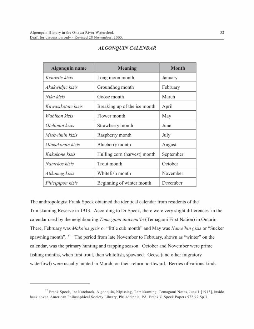
Algonquin History in the Ottawa River Watershed.Draft for discussion only - Revised 28 November, 2005.
32
Frank Speck, 1st Notebook. Algonquin, Nipissing, Temiskaming, Temagami Notes, June 1 [1913], inside87
back cover. American Philosophical Society Library, Philadelphia, PA. Frank G Speck Papers 572.97 Sp 3.
ALGONQUIN CALENDAR
Algonquin name Meaning Month
Kenozitc kizis Long moon month January
Akakwidjic kizis Groundhog month February
Nika kizis Goose month March
Kawasikototc kizis Breaking up of the ice month April
Wabikon kizis Flower month May
Otehimin kizis Strawberry month June
Miskwimin kizis Raspberry month July
Otakakomin kizis Blueberry month August
Kakakone kizis Hulling corn (harvest) month September
Namekos kizis Trout month October
Atikameg kizis Whitefish month November
Piticipipon kizis Beginning of winter month December
The anthropologist Frank Speck obtained the identical calendar from residents of the
Timiskaming Reserve in 1913. According to Dr Speck, there were very slight differences in the
calendar used by the neighbouring Tima’gami anicena’bi (Temagami First Nation) in Ontario.
There, February was Mako’ns gizis or “little cub month” and May was Name’bin gizis or “Sucker
spawning month”. The period from late November to February, shown as “winter” on the87
calendar, was the primary hunting and trapping season. October and November were prime
fishing months, when first trout, then whitefish, spawned. Geese (and other migratory
waterfowl) were usually hunted in March, on their return northward. Berries of various kinds

Algonquin History in the Ottawa River Watershed.Draft for discussion only - Revised 28 November, 2005.
33
were gathered in June, July and August. The reference to “corn hulling” (September) shows that
the Algonquins still practised agriculture.
According to the ethnological literature, Algonquin and other anishnabeg (such as the
Ojibway) were organized in bands, and the band, not the tribe or nation, was the land-holding
group. At the time of his 1913 fieldwork, Frank Speck found that the traditional Algonquin
way of life had declined considerably over the previous half-century, as the pressure of
settlement and resource development had led many Band members to take up farming and
logging. Nevertheless, he was able to obtain considerable detail about life in previous
generations. He also discovered that the bands living both to the east and west of Timiskaming
were much more traditional. In his report, published in 1915, Dr Speck states that extended
families were the building blocks of Algonquin bands. And land use was the key to Algonquin
social and political organization. Watersheds were the basic unit of traditional land
management, serving as boundaries for family, band and tribal territories. Rivers and lakes
were the “highways” Algonquin people used to travel around their territory:
The social units composing the band are the families, which consist of individualsrelated by descent and blood together with other women married to the men of thefamily [...] The main bond of union and interest in these groups is the familyhunting territory, in which all the male members share the right of hunting andfishing. These hunting ‘lots’ or territories (nok.i’wak.i’ “hunting ground”) aremore or less fixed tracts of country whose boundaries are determined by certainrivers, ridges, lakes, or other natural landmarks, such as swamps and clumps ofcedars or pines.
Hunting outside of one’s inherited territory was punishable occasionally by death.More often, however, trespass was punished by conjuring against the offender’slife or health. Each family as a rule, had some shaman in its ranks who could becalled upon to work malefic influence upon a member of another family who wasknown to have intruded. [...]
Permission however could be obtained by a man to hunt in another’s territory. This happened frequently as an exchange of courtesy between families when thegame supply of one or the other had become impoverished. These privileges were,

Algonquin History in the Ottawa River Watershed.Draft for discussion only - Revised 28 November, 2005.
34
Frank G. Speck, "Family Hunting Territories and Social Life of Various Algonkian Bands in the Ottawa88
Valley" Memoir 70, Anthropological Series No 8, Geological Survey (Ottawa: Department of Mines, 1915), pp.3-6.
Petition of Philemon Wright to Lieutenant Governor of Lower Canada, 30 Dec 1802. NAC RG1 L3L Vol89
208 on Reel C-2570 pp. 97177-97181; Philemon Wright, “An Account of the First Settlement of the Township ofHull on the Ottawa River, Lower Canada, 1823". National Library FC 2495 H84 W75 1970Z. ”
nevertheless, only temporary, except in a few cases where they were obtainedthrough marriage [...]
The rights in the hunting territories were inherited paternally. Occasionally, toadjust matters, an old man would subdivide his district among several sons, thuscreating new family groups, though, of course, these would recognize mutualprivileges. For the most part, the territories were fairly rigid and permanent [...]When the male claimants to a territory became extinct, it was divided up amongthe relatives in other family groups. 88
ALGONQUIN PEOPLE IN THE NINETEENTH CENTURY
The development pressure that Frank Speck mentioned in his report was a product of the
nineteenth century. Until about 1803, the government of Lower Canada had respected Indian title
(as the government of Upper Canada would continue to do). The government would not issue
patents or warrants of survey for lands that were still in the possession of their Indian proprietors.
But around the time of Philemon Wright’s settlement of Hull Township, which was the first
serious development in the Ottawa valley, local authorities changed their attitude. The
Algonquins and Nipissings had objected to the presence of settlers, but Wright later claimed that
government officials had helped him assert his title. In fact, there was a division of authority89
within the colonial administration. The settler government was responsible for lands and
resources. But Indian Affairs was an Imperial responsibility, and Indian Department officials
were not answerable to the government of Lower Canada. Particularly after 1820, as settlement
and lumbering slowly proceeded up the Ottawa valley, the Algonquins and Nipissings of Lake of
Two Mountains lodged continuous protests with the Indian Department, who would convey their

Algonquin History in the Ottawa River Watershed.Draft for discussion only - Revised 28 November, 2005.
35
Petition from Chiefs of the Algonquin and Nipissing Tribes of Indians at the Lake of Two Mountains to90
John Johnson. NAC RG10 Vol.16: pp. 12691-12694; Sir John Johnson, Montreal to Colonel Darling, MilitarySecretary (NAC RG10 Vol.494: pp. 31028-31030 on Reel C-13,341.
James Hughes, Indian Department, Montreal, to Capt Dominique Ducharme, 20 Sep 1838. NAC RG1091
Vol.97: p.40073.
complaints to the local executive, who would generally ignore the protests. The Algonquins90
and Nipissings did, however, make their own arrangements with local settlers, requesting and
receiving rental payments, particularly for islands in the Ottawa River. For more than thirty
years, the Indian Department acknowledged the validity of those rents, and even collected them
on occasion. But the government of Lower Canada refused to recognize them, and proceeded91
to survey and patent lands without consideration for Indian claims. This process accelerated
when Lower and Upper Canada were combined in 1840 to form the Province of Canada.
Beginning in the late 1840's, a number of Algonquins and a few of the Nipissings moved their
summer residence from the mission village at Oka to Kitigan Zibi (River Desert), a tributary of
the Gatineau River which had always been part of their winter hunting grounds, and began
petitioning the government of the province of Canada for title. Oblate missionaries also urged
the government to set aside these lands as an Indian Reserve, and this was done by statute and
executive order in the period 1851-53. That reserve came to be known as Maniwaki, or "Mary
Land" in the anishinabe language. The Oblates also pressed simultaneously for the creation of a
reserve at the head of Lake Temiskaming, where they hoped to form a mission for the many
traditional bands who lived on the upper Ottawa and in the neighbouring Hudson’s Bay
Company territory. What is now the Timiskaming Indian Reserve would also be created by
statute and executive order in 1851-53.
But although the government styled the reserves at River Desert and Timiskaming as places of
residence for all the Nipissings and Algonquins, as well as other bands in the upper Ottawa
valley, this solution was overwhelming rejected by the majority of Algonquin-speaking people.
For the most part, the only people who had settled at River Desert and Timiskaming by 1900

Algonquin History in the Ottawa River Watershed.Draft for discussion only - Revised 28 November, 2005.
36
Petition from Algonquin & Nipissing Indians to Lord Sydenham, Governor of Lower Canada. NAC92
RG10 Vol.99: pp. 41,092-49,100 on Reel C-11,471.
were members of traditional bands whose hunting grounds already included those reserves, or
who lived in the immediate neighbourhood. Even after 1851, the Algonquins and Nipissings of
Lake of Two Mountains continued to press for protection of their traditional territories and to
have reserve lands set aside at Oka. And if that was not possible, then they wanted Calumet and
neighbouring islands on the Ottawa River set apart as a reserve for them. 92
In response to the overwhelming wave of settlement and resource development which was then
sweeping over the Ottawa valley, individual Algonquin and Nipissing bands began to press for
reserve lands within their own traditional territories. In the 1840's, for example, the Algonquin
Chief Pierre Shawanepinesi was petitioning for a reserve for his band in Bedford township north
of Kingston. Land was set aside to become an Indian Reserve, but was then withdrawn due to
lumbering interests. Other Nipissings and Algonquins wanted a reserve around their summer
village at Golden Lake on the Bonnechere River, within winter grounds that they had been
occupying since at least the late eighteenth century. These lands would later become the Golden
Lake Indian reserve. Most bands, however, were not as successful. After 1867, the anishnabeg
of Grand Lac and Barriere Lake petitioned the government of Canada for reserve land at their
respective localities and began clearing land. So did the Algonquin people who lived along the
Kipawa River drainage, including ancestors of the Eagle Village and Wolf Lake First Nations,
who began clearing land both on Kipawa Lake and at nearby Grassy Lake in the early 1870's. But
none of these groups succeeded in having their land and resource rights protected. Apart from
the Algonquins living on the Reserves at Timiskaming, River Desert and Golden Lake, the
governments of Canada, Ontario and Quebec, like the colonial governments that proceeded
them, consistently treated Algonquin people as squatters on their own land. Up to the present
time, the Algonquins have never signed a land treaty, pursuant to the Constitution of Canada,
for the Kichisipi watershed or the remainder of their traditional territories.