airborne lidar report - oregon department of geology … · airborne lidar report ... fema hq...
TRANSCRIPT

Airborne LiDAR Report
FEMA HQ MALHEUR, OR QL1 LIDAR
Contract Number: G10PC00057
Task Number: G15PD00642
Contractor: Woolpert, Inc.
Woolpert Project # 75818
October 2016

i
Airborne LiDAR Report
UNITED STATES GEOLOGICAL SURVEY
FEMA HQ Malheur OR QL1 Lidar
Contract Number: G10PC00057
Task Number: G15PD00642
Woolpert 4454 Idea Center Boulevard Dayton, Ohio 45430.1500
Phone: 937.461.5660
Table of Contents Section 1: Overview ................................................................................................................................................................................ 1-1
Section 2: Acquisition.............................................................................................................................................................................. 2-1
Section 3: Lidar Data Processing ............................................................................................................................................................. 3-1
Section 4: Hydrologic Flattening ............................................................................................................................................................. 4-1
Section 5: Accuracy Assessment ............................................................................................................................................................. 5-1
Section 6: Flight Logs .............................................................................................................................................................................. 6-1
Section 7: Final Deliverables ................................................................................................................................................................... 7-1
List of Figures Figure 1.1: Lidar Task Order AOI ............................................................................................................................................................. 1-2
Figure 2.1: LiDAR Flight Layout, FEMA HQ Malheur OR QL1 Lidar ......................................................................................................... 2-3
Figure 4.1: Example Hydrologic Breaklines ............................................................................................................................................. 4-1
Figure 4.2: DEM Generated from Lidar Bare Earth Point Data ............................................................................................................... 4-2
Figure 4.3: DEM Generated from Lidar with Breaklines ......................................................................................................................... 4-2
Figure 5.1: LIDAR Relative Accuracy Histogram ...................................................................................................................................... 5-9

ii
List of Tables
Table 1.1: Dual-Head DragonEye (DE) Specifications ............................................................................................................................. 1-1
Table 2.1: The Leica DragonEye LiDAR System specifications: ............................................................................................................... 2-1
Table 2.2: Airborne Lidar Acquisition Flight Summary ............................................................................................................................ 2-2
Table 3.1: GNSS Base Station .................................................................................................................................................................. 3-2
Table 5.1: Overall Vertical Accuracy Statistics ........................................................................................................................................ 5-1
Table 5.2: RAW Swath Quality Check Point Analysis NVA ..................................................................................................................... 5-1
Table 5.3: NVA Check Point Analysis DEM ............................................................................................................................................. 5-4
Table 5.4: VVA Quality Check Point Analysis DEM ................................................................................................................................. 5-6

FEMA HQ Malheur OR QL1 Lidar
United States Geological Survey Airborne LiDAR Report October 2016 1-1
Section 1: Overview
TASK ORDER NAME: FEMA HQ Malheur OR QL1 Lidar
Project: #75818
This report contains a comprehensive outline of the FEMA HQ Malheur OR QL1 Lidar Processing task order for the United States Geological Survey (USGS). This task is issued under USGS Contract No. G10PC00057, Task Order No. G15PD00642. This task order requires lidar data to be acquired over Malheur County, OR (approximately 863 square miles). The lidar was collected and processed to meet a maximum Nominal Post Spacing (NPS) of 0.35 meters. The NPS assessment is made against single swath, first return data located within the geometrically usable center portion (typically ~90%) of each swath. The data was collected using a Dual-Head DragonEye (DE) sensor. The sensor was mounted in a Leica PAV100 gyro-stabilized mount integrated with a NovAtel SPAN GNSS and LCI-100C IMU. This sensor collects up to four returns (echo) per pulse, as well as intensity data, for the first three returns. The aerial lidar was collected at the following sensor specifications:
Table 1.1: Dual-Head DragonEye (DE) Specifications Post Spacing 0.35 m
AGL (Above Ground Level) average flying height 900 m
Average Ground Speed: 125 knots / 144 mph
Field of View (full) 40 degrees
Pulse Rate 520 kHz
Scan Rate 50 Hz
Side Lap 15%
LiDAR data was produced in NAD83(2011) UTM11N. Coordinate positions were specified in units of meters. The vertical datum used for the project was referenced to NAVD 1988, meters, GEOID12B.

FEMA HQ Malheur OR QL1 Lidar
United States Geological Survey Airborne LiDAR Report October 2016 1-2
Figure 1.1: Lidar Task Order AOI

FEMA HQ Malheur OR QL1 Lidar
United States Geological Survey Airborne LiDAR Report October 2016 2-1
Section 2: Acquisition The LiDAR data was acquired with a Leica Leica Dual-Head DragonEye (DE) sensor, on board Woolpert’s Cessna aircraft. The Leica system, developed by Leica of Herrburgg, Switzerland. The innovative dual scanner head design of the DragonEye features a unique oblique scan pattern. In one single pass, each ground target may be illuminated by four laser shots at multiple incidence angles from ±8 to ±20 degrees, maximizing vertical surface definition and minimizing shadows in the survey data.Each topographic laser operates in the infra-red spectrum at 1064nm. Up to 15 returns per pulse are acquired from each laser.
Table 2.1: The Leica DragonEye LiDAR System has the following specifications:
Prior to mobilizing to the project site, flight crews coordinated with the necessary Air Traffic Control personnel to ensure airspace access.
Crews were onsite, operating a Global Navigation Satellite System (GNSS) Base Station for the airborne GPS support.
The LiDAR data was collected in one (25) missions, flown as close together as the weather permitted, to ensure consistent ground conditions across the project area. An initial quality control process was performed immediately on the LiDAR data to review the data coverage, airborne GPS data, and trajectory solution.

FEMA HQ Malheur OR QL1 Lidar
United States Geological Survey Airborne LiDAR Report October 2016 2-2
Table 2.2: Airborne Lidar Acquisition Flight Summary
Date of Mission Lines Flown
Mission Time (UTC) Wheels Up/ Wheels Down
March 23, 2016 68-85, 15:44 - 19:33
March 23, 2016 86-99 21:41 - 1:26
March 24, 2016 100 -105, 143 -152 17:30 - 22:06
March 25, 2016 21-41 14:36 - 19:02
March 26, 2016 1-20 15:31 - 20:12
March 26, 2016 42-60 21:48 - 23:59
March 26, 2016 61-67, 153-158 15:36 - 19:02
March 30, 2016 1-6, 18:43 -20:18
March 31, 2016 159-172 14:52 - 19:02
March 31, 2016 173 – 188 21:03 - 01:15
March 31, 2016 189–201, 221-222, 243 18:48 - 22:58
April 2, 2016 27-42 16:49 - 19:48
April 2, 2016 106-118, 120-124 22:15 - 02:02
April 3, 2016 124-142 15:40 - 18:35
April 6, 2016 244-255 22:29 - 01:31
April 7, 2016 256-273 15:11 - 19:11
April 7, 2016 274-285 20:40 - 23:55
April 8, 2016 281-290, 308-319 14:26 - 18:57
April 8, 2016 291-307, 320-322 20:24 - 00:00
April 9, 2016 323-336 15:15 - 19:02
June 8, 2016 1-6 23:59 - 1:20
June 9, 2016 1-6 20:00 - 23:35
June 10, 2016 125-142,479-487 14:36 - 18:26
June 10, 2016 202-222,488 20:20-23:17
June 15, 2016 222,481,489-499 14:04-16:18

FEMA HQ Malheur OR QL1 Lidar
United States Geological Survey Airborne LiDAR Report October 2016 2-3
Figure 2.1: LiDAR Flight Layout, FEMA HQ Malheur OR QL1
Lidar

FEMA HQ Malheur OR QL1 Lidar
United States Geological Survey Airborne LiDAR Report October 2016 3-1
Section 3: LiDAR Data Processing
Applications and Work Flow Overview
Initial data coverage analysis and quality checks to ensure there were no potential system issues were carried out in the field prior to demobilization of the sensor. In general, data were initially processed in Leica’s Lidar Survey Studio (LSS) using final processed trajectory information. LAS files from LSS were imported to a Terrascan project where spatial algorithms were used to remove gross system noise and a basic ground classification was conducted per flight line for Terra Match use. TMatch was then run on the project, and a comparison to the lidar control points was conducted. Final trajectory data were post processed in NovAtel Inertial Explorer. Base station data were converted to GPB format and imported with aircraft GNSS and IMU data. Inertial Explorer accounts for the fixed offset between the reference point and IMU and uses a multi-pass algorithm to compute a tightly-coupled solution. Lidar processing was conducted using the Leica Lidar Survey Studio (LSS) software. Calibration information, along with processed trajectory information were combined with the raw laser data to create an accurately georeferenced lidar point cloud for the entire survey in LAS v1.2 format. All points from the topographic lasers include 16-bit intensity values. Additional QC steps were then performed in LSS prior to import to Terrascan. For example, spot checks were made on the data to ensure the front and back of the scans remained in alignment and no calibration or system issues were apparent prior to further data editing in Terrascan.
Global Navigation Satellite System (GNSS)–Inertial
Measurement Unit (IMU) Trajectory Processing
Equipment
Flight navigation during the LiDAR data acquisition mission is performed using IGI CCNS (Computer Controlled Navigation System). The pilots are skilled at maintaining their planned trajectory, while holding the aircraft steady and level. If atmospheric conditions are such that the trajectory, ground speed, roll, pitch and/or heading cannot be properly maintained, the mission is aborted until suitable conditions occur.
The aircraft is configured with a NovAtel SPAN GNSS and LCI-100C IMU.
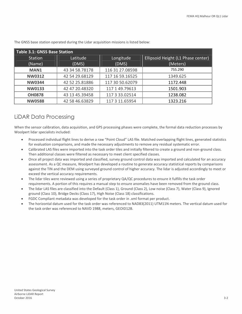
Base stations were set by acquisition staff and were used to support the LiDAR data acquisition. The base stations used during the LiDAR acquisition missions are listed on the next page:
FEMA HQ Malheur OR QL1 Lidar
United States Geological Survey Airborne LiDAR Report October 2016 3-2
The GNSS base station operated during the Lidar acquisition missions is listed below:
Table 3.1: GNSS Base Station
Station (Name)
Latitude (DMS)
Longitude (DMS)
Ellipsoid Height (L1 Phase center) (Meters)
MAN1 43 34 58.78178 116 31 27.08598 755.290
NW0312 42 54 29.68129 117 16 59.16525 1349.625
NW0344 42 52 25.81886 117 30 50.62079 1172.448
NW0133 42 47 20.48320 117 1 49.79613 1501.903
OH0878 43 13 45.39458 117 3 33.02514 1238.082
NW0588 42 58 46.63829 117 3 11.65954 1323.216
LiDAR Data Processing When the sensor calibration, data acquisition, and GPS processing phases were complete, the formal data reduction processes by Woolpert lidar specialists included:
Processed individual flight lines to derive a raw “Point Cloud” LAS file. Matched overlapping flight lines, generated statistics for evaluation comparisons, and made the necessary adjustments to remove any residual systematic error.
Calibrated LAS files were imported into the task order tiles and initially filtered to create a ground and non-ground class. Then additional classes were filtered as necessary to meet client specified classes.
Once all project data was imported and classified, survey ground control data was imported and calculated for an accuracy assessment. As a QC measure, Woolpert has developed a routine to generate accuracy statistical reports by comparisons against the TIN and the DEM using surveyed ground control of higher accuracy. The lidar is adjusted accordingly to meet or exceed the vertical accuracy requirements.
The lidar tiles were reviewed using a series of proprietary QA/QC procedures to ensure it fulfills the task order requirements. A portion of this requires a manual step to ensure anomalies have been removed from the ground class.
The lidar LAS files are classified into the Default (Class 1), Ground (Class 2), Low noise (Class 7), Water (Class 9), Ignored ground (Class 10), Bridge Decks (Class 17), High Noise (Class 18) classifications.
FGDC Compliant metadata was developed for the task order in .xml format per product.
The horizontal datum used for the task order was referenced to NAD83(2011) UTM11N meters. The vertical datum used for the task order was referenced to NAVD 1988, meters, GEOID12B.

FEMA HQ Malheur OR QL1 Lidar
United States Geological Survey Airborne LiDAR Report October 2016 4-1
Section 4: Hydrologic Flattening
HYDROLOGIC FLATTENING OF LIDAR DEM DATA
FEMA HQ Malheur OR QL1 Lidar processing task order required the compilation of breaklines defining water bodies and rivers. The breaklines were used to perform the hydrologic flattening of water bodies, and gradient hydrologic flattening of double line streams and rivers. Lakes, reservoirs and ponds, at a minimum size of 2-acre or greater, were compiled as closed polygons. The closed water bodies were collected at a constant elevation. Rivers and streams, at a nominal minimum width of 30 meters (100 feet), were compiled in the direction of flow with both sides of the stream maintaining an equal gradient elevation.
LIDAR DATA REVIEW AND PROCESSING
Woolpert utilized the following steps to hydrologically flatten the water bodies and for gradient hydrologic flattening of the double line streams within the existing lidar data.
1. Woolpert used the newly acquired lidar data to manually draw the hydrologic features in a 2D environment using the lidar intensity and bare earth surface. Open Source imagery was used as reference when necessary.
2. Woolpert utilizes an integrated software approach to combine the lidar data and 2D breaklines. This process “drapes” the 2D breaklines onto the 3D lidar surface model to assign an elevation. A monotonic process is performed to ensure the streams are consistently flowing in a gradient manner. A secondary step within the program verifies an equally matching elevation of both stream edges. The breaklines that characterize the closed water bodies are draped onto the 3D lidar surface and assigned a constant elevation at or just below ground elevation.
3. The lakes, reservoirs and ponds, at a minimum size of 2-acre or greater and streams at a minimum size of 30 meters (100 feet) nominal width, were compiled to meet task order requirements. Figure 4.1 illustrates an example of 30 meters (100 feet) nominal streams identified and defined with hydrologic breaklines. The breaklines defining rivers and streams, at a nominal minimum width of 30 meters (100 feet), were draped with both sides of the stream maintaining an equal gradient elevation.
4. All ground points were reclassified from inside the hydrologic feature polygons to water, class nine (9). 5. All ground points were reclassified from within a buffer along the hydrologic feature breaklines to buffered ground, class
ten (10). 6. The lidar ground points and hydrologic feature breaklines were used to generate a new digital elevation model (DEM).
Figure 4.1: Example Hydrologic Breaklines

FEMA HQ Malheur OR QL1 Lidar
United States Geological Survey Airborne LiDAR Report October 2016 4-2
Figure 4.2 reflects a DEM generated from original lidar bare earth point data prior to the hydrologic flattening process. Note the “tinning” across the lake surface.
Figure 4.3 reflects a DEM generated from lidar with breaklines compiled to define the hydrologic features. This figure illustrates the results of adding the breaklines to hydrologically flatten the DEM data. Note the smooth appearance of the lake surface in the DEM.
Figure 4.2 Figure 4.3
Terrascan was used to add the hydrologic breakline vertices and export the lattice models. The hydrologically flattened DEM data was provided to USGS in ERDAS .IMG format.
The hydrologic breaklines compiled as part of the flattening process were provided to the USGS as an ESRI Shapefile The breaklines defining the water bodies greater than 2-acre and for the gradient flattening of all rivers and streams at a nominal minimum width of 30 meters (100 feet) were provided as a Polygon-Z and Polyline-Z shape file, respectively.
DATA QA/QC
Initial QA/QC for this task order was performed in Global Mapper v15, by reviewing the grids and hydrologic breakline features. Additionally, ESRI software and proprietary methods were used to review the overall connectivity of the hydrologic breaklines. Edits and corrections were addressed individually by tile. If a water body breakline needed to be adjusted to improve the flattening of the DEM data, the area was cross referenced by tile number, corrected accordingly, a new DEM file was regenerated and reviewed.

FEMA HQ Malheur OR QL1 Lidar
United States Geological Survey Airborne LiDAR Report October 2016 5-1
Section 5: Accuracy Assessment
Final Vertical Accuracy Assessment
The vertical accuracy statistics were calculated by comparison of the LiDAR bare earth points to the ground surveyed QA/QC points.
Table 5.1: Overall Vertical Accuracy Statistics Average error +0.038 meter
Minimum error -0.035 meter
Maximum error +0.103 meter
Average magnitude 0.041 meter
Root mean square 0.049 meter
Standard deviation 0.031 meter
Table 5.2: RAW Swath Quality Check Point Analysis NVA
Point ID Easting (meter)
Northing (meter)
Elevation (meter)
TIN Elevation (meter)
Dz (meter)
2002 453619.467 4755247.349 1146.332 1146.340 0.008
2002A 453619.473 4755276.060 1146.378 1146.400 0.022
2003 456840.947 4746398.211 1169.461 1169.470 0.009
2003A 456799.779 4746385.845 1169.531 1169.550 0.019
2004 449120.732 4743450.540 1030.014 1030.020 0.006
2004A 449109.274 4743470.353 1029.701 1029.710 0.009
2005 447417.225 4748410.329 1172.011 1172.100 0.089
2005A 447413.161 4748396.562 1172.303 1172.390 0.087
2006 439694.361 4739171.334 1092.589 1092.610 0.021
2006A 439708.559 4739187.964 1092.253 1092.230 -0.023
2007 472889.354 4760363.792 1302.940 1302.990 0.050
2007A 472885.802 4760379.309 1303.016 1303.010 -0.006
2008 440505.939 4745470.073 1058.527 1058.530 0.003
2008A 440488.631 4745478.307 1058.250 1058.250 0.000
2009 462857.209 4738203.720 1282.917 1282.950 0.033
2009A 462831.067 4738202.555 1282.749 1282.790 0.041
2010 454825.808 4738485.999 1201.828 1201.840 0.012
2010A 454812.814 4738504.512 1201.775 1201.820 0.045
2011 459708.448 4734084.839 1285.185 1285.220 0.035
2011A 459729.060 4734079.856 1285.136 1285.160 0.024
2012 497921.233 4788717.961 1266.216 1266.240 0.024
2012A 497898.089 4788692.273 1266.135 1266.180 0.045
2013 495867.601 4774862.399 1393.017 1393.020 0.003
2013A 495847.242 4774851.187 1393.022 1393.030 0.008
2014 495582.152 4758100.338 1338.191 1338.260 0.069
2014A 495607.488 4758115.485 1338.276 1338.350 0.074

FEMA HQ Malheur OR QL1 Lidar
United States Geological Survey Airborne LiDAR Report October 2016 5-2
2015 487417.998 4759171.314 1320.007 1320.070 0.063
2015A 487438.262 4759179.482 1320.061 1320.130 0.069
2016 484475.689 4766285.878 1416.457 1416.540 0.083
2016A 484465.733 4766269.416 1416.698 1416.710 0.012
2017 474815.441 4766638.035 1309.215 1309.230 0.015
2017A 474815.975 4766663.558 1310.399 1310.430 0.031
2018 473096.096 4756306.269 1290.754 1290.770 0.016
2018A 473118.159 4756306.490 1291.048 1291.100 0.052
2019 477171.406 4752248.858 1295.404 1295.460 0.056
2019A 477156.357 4752249.126 1295.174 1295.230 0.056
2020 473919.473 4747019.777 1302.331 1302.410 0.079
2020A 473917.972 4747060.307 1302.618 1302.680 0.062
2020B 472329.562 4755519.588 1289.531 1289.600 0.069
2020C 472313.379 4755527.023 1289.207 1289.270 0.063
2021 463656.482 4738538.223 1264.349 1264.380 0.031
2021A 463675.825 4738529.754 1264.774 1264.810 0.036
2022 492068.435 4788116.732 1339.560 1339.650 0.090
2022A 492137.379 4788117.756 1339.468 1339.530 0.062
2023 461216.116 4751531.844 1190.392 1190.420 0.028
2023A 461199.971 4751529.617 1190.412 1190.450 0.038
2024 483055.499 4755043.979 1341.631 1341.650 0.019
2024A 483065.891 4755031.232 1340.745 1340.710 -0.035
2025 486127.907 4770735.356 1347.639 1347.660 0.021
2025A 486108.149 4770717.392 1347.915 1347.940 0.025
2026 498057.749 4742395.320 1426.693 1426.790 0.097
2026A 498050.107 4742435.219 1425.924 1426.000 0.076
2027B 498215.046 4743466.105 1414.759 1414.790 0.031
2027C 498199.212 4743467.094 1414.457 1414.540 0.083
2029 460696.163 4733808.927 1288.007 1288.090 0.083
2029A 460717.659 4733804.859 1288.220 1288.240 0.020
2030 451071.035 4731783.530 1170.116 1170.150 0.034
2030A 451069.800 4731801.511 1169.363 1169.390 0.027
2031 463882.920 4738678.412 1268.998 1269.050 0.052
2031A 463899.921 4738686.813 1269.018 1269.070 0.052
2032 463895.417 4747512.652 1238.540 1238.560 0.020
2032A 463893.110 4747531.785 1237.923 1237.980 0.057
2033 448772.332 4736811.636 1107.028 1107.080 0.052
2033A 448785.162 4736797.939 1107.567 1107.610 0.043
2034 494268.369 4766292.463 1361.026 1361.010 -0.016
2034A 494294.725 4766274.432 1360.084 1360.120 0.036
2035 474819.182 4778284.471 1432.435 1432.470 0.035
2035A 474788.981 4778281.116 1433.696 1433.750 0.054
2036 481391.481 4774059.437 1337.751 1337.840 0.089
2036A 481409.324 4774071.634 1337.587 1337.690 0.103
2037 487834.963 4774069.036 1358.388 1358.460 0.072

FEMA HQ Malheur OR QL1 Lidar
United States Geological Survey Airborne LiDAR Report October 2016 5-3
2037A 487836.263 4774034.649 1357.638 1357.730 0.092
2038 497560.270 4751598.853 1390.186 1390.190 0.004
2038A 497571.011 4751586.808 1390.056 1390.090 0.034
2039 445977.136 4735788.080 1189.857 1189.850 -0.007
2039A 445979.760 4735809.832 1189.750 1189.730 -0.020
2041 480216.951 4774514.033 1337.006 1337.030 0.024
2041A 480209.778 4774527.256 1336.831 1336.890 0.059
2042 480552.719 4761493.858 1337.082 1337.060 -0.022
2042A 480578.038 4761473.666 1336.422 1336.410 -0.012
2043 470120.701 4748630.803 1303.278 1303.280 0.002
2043A 470118.207 4748643.596 1303.052 1303.080 0.028
2044 444644.239 4741168.565 1118.337 1118.340 0.003
2044A 444630.107 4741177.658 1118.592 1118.590 -0.002
2045 446812.921 4746415.157 1030.161 1030.230 0.069
2045A 446822.885 4746427.323 1030.972 1031.040 0.068
2046 457126.107 4751351.610 1138.661 1138.690 0.029
2046A 457112.895 4751352.214 1137.795 1137.840 0.045
2047 473467.413 4762797.839 1305.907 1305.920 0.013
2047A 473448.683 4762803.968 1306.025 1306.020 -0.005
2048 477261.903 4773300.269 1395.352 1395.420 0.068
2048A 477248.494 4773282.505 1394.901 1394.970 0.069
2049 487377.479 4767362.523 1383.816 1383.900 0.084
2049A 487365.529 4767342.744 1384.525 1384.610 0.085
2050 485665.268 4757610.966 1330.395 1330.430 0.035
2050A 485657.795 4757623.509 1329.952 1330.020 0.068
2051 496802.930 4782277.476 1271.454 1271.500 0.046
2051A 496812.333 4782252.481 1271.974 1272.010 0.036
2052 490975.999 4757092.339 1327.114 1327.180 0.066
2052A 491009.279 4757092.388 1327.288 1327.360 0.072
2053 472275.188 4753062.520 1307.300 1307.350 0.050
2053A 472275.437 4753026.869 1307.618 1307.640 0.022
2054 441545.937 4744040.015 1111.187 1111.180 -0.007
2055 443530.774 4744336.526 1057.829 1057.820 -0.009
2056 458314.113 4734437.972 1253.494 1253.530 0.036
2057 467856.290 4730079.708 1389.482 1389.530 0.048
VERTICAL ACCURACY CONCLUSIONS Raw Swath Non-Vegetated Vertical Accuracy (NVA) Tested 0.096 Meters Non vegetated vertical accuracy at a 95 percent confidence level, derived according to NSSDA, in open terrain using (RMSEz) x 1.96000 as defined by the National Standards for Spatial Data Accuracy (NSSDA); assessed and reported using National Digital Elevation Program (NDEP)/ASPRS Guidelines and tested against the TIN using all points. LAS Swath Non-Vegetated Vertical Accuracy (NVA) Tested 0.072 Meters Non vegetated vertical accuracy at a 95 percent confidence level, derived according to NSSDA, in open terrain using (RMSEz) x 1.96000 as defined by the National Standards for Spatial Data

FEMA HQ Malheur OR QL1 Lidar
United States Geological Survey Airborne LiDAR Report October 2016 5-4
Accuracy (NSSDA); assessed and reported using National Digital Elevation Program (NDEP)/ASPRS Guidelines and tested against the TIN using ground points.
Table 5.3: NVA Check Point Analysis DEM
Point ID Easting (meter)
Northing (meter)
Elevation (meter)
DEM Elevation (meter)
Dz (meter)
2002 453619.467 4755247.349 1146.332 1146.310 0.022
2002A 453619.473 4755276.06 1146.378 1146.380 -0.002
2003 456840.947 4746398.211 1169.461 1169.460 0.001
2003A 456799.779 4746385.845 1169.531 1169.560 -0.029
2004 449120.732 4743450.54 1030.014 1030.020 -0.006
2004A 449109.274 4743470.353 1029.701 1029.710 -0.009
2005 447417.225 4748410.329 1172.011 1172.080 -0.069
2005A 447413.161 4748396.562 1172.303 1172.350 -0.047
2006 439694.361 4739171.334 1092.589 1092.600 -0.011
2006A 439708.559 4739187.964 1092.253 1092.230 0.023
2007 472889.354 4760363.792 1302.94 1302.940 0
2007A 472885.802 4760379.309 1303.016 1303.000 0.016
2008 440505.939 4745470.073 1058.527 1058.510 0.017
2008A 440488.631 4745478.307 1058.25 1058.240 0.01
2009 462857.209 4738203.72 1282.917 1282.930 -0.013
2009A 462831.067 4738202.555 1282.749 1282.760 -0.011
2010 454825.808 4738485.999 1201.828 1201.850 -0.022
2010A 454812.814 4738504.512 1201.775 1201.790 -0.015
2011 459708.448 4734084.839 1285.185 1285.200 -0.015
2011A 459729.06 4734079.856 1285.136 1285.150 -0.014
2012 497921.233 4788717.961 1266.216 1266.210 0.006
2012A 497898.089 4788692.273 1266.135 1266.160 -0.025
2013 495867.601 4774862.399 1393.017 1392.990 0.027
2013A 495847.242 4774851.187 1393.022 1393.010 0.012
2014 495582.152 4758100.338 1338.191 1338.250 -0.059
2014A 495607.488 4758115.485 1338.276 1338.340 -0.064
2015 487417.998 4759171.314 1320.007 1320.040 -0.033
2015A 487438.262 4759179.482 1320.061 1320.110 -0.049
2016 484475.689 4766285.878 1416.457 1416.460 -0.003
2016A 484465.733 4766269.416 1416.698 1416.650 0.048
2017 474815.441 4766638.035 1309.215 1309.220 -0.005
2017A 474815.975 4766663.558 1310.399 1310.410 -0.011
2018 473096.096 4756306.269 1290.754 1290.750 0.004
2018A 473118.159 4756306.49 1291.048 1291.010 0.038
2019 477171.406 4752248.858 1295.404 1295.420 -0.016
2019A 477156.357 4752249.126 1295.174 1295.180 -0.006
2020 473919.473 4747019.777 1302.331 1302.370 -0.039
2020A 473917.972 4747060.307 1302.618 1302.630 -0.012
2020B 472329.562 4755519.588 1289.531 1289.550 -0.019
2020C 472313.379 4755527.023 1289.207 1289.200 0.007
2021 463656.482 4738538.223 1264.349 1264.380 -0.031
2021A 463675.825 4738529.754 1264.774 1264.740 0.034
2022 492068.435 4788116.732 1339.56 1339.640 -0.08
2022A 492137.379 4788117.756 1339.468 1339.500 -0.032

FEMA HQ Malheur OR QL1 Lidar
United States Geological Survey Airborne LiDAR Report October 2016 5-5
2023 461216.116 4751531.844 1190.392 1190.410 -0.018
2023A 461199.971 4751529.617 1190.412 1190.450 -0.038
2024 483055.499 4755043.979 1341.631 1341.640 -0.009
2024A 483065.891 4755031.232 1340.745 1340.680 0.065
2025 486127.907 4770735.356 1347.639 1347.640 -0.001
2025A 486108.149 4770717.392 1347.915 1347.920 -0.005
2026 498057.749 4742395.32 1426.693 1426.740 -0.047
2026A 498050.107 4742435.219 1425.924 1425.960 -0.036
2027B 498215.046 4743466.105 1414.759 1414.770 -0.011
2027C 498199.212 4743467.094 1414.457 1414.530 -0.073
2029 460696.163 4733808.927 1288.007 1288.020 -0.013
2029A 460717.659 4733804.859 1288.22 1288.220 0
2030 451071.035 4731783.53 1170.116 1170.130 -0.014
2030A 451069.8 4731801.511 1169.363 1169.380 -0.017
2031 463882.92 4738678.412 1268.998 1269.010 -0.012
2031A 463899.921 4738686.813 1269.018 1269.050 -0.032
2032 463895.417 4747512.652 1238.54 1238.470 0.07
2032A 463893.11 4747531.785 1237.923 1237.900 0.023
2033 448772.332 4736811.636 1107.028 1107.030 -0.002
2033A 448785.162 4736797.939 1107.567 1107.550 0.017
2034 494268.369 4766292.463 1361.026 1361.010 0.016
2034A 494294.725 4766274.432 1360.084 1360.110 -0.026
2035 474819.182 4778284.471 1432.435 1432.470 -0.035
2035A 474788.981 4778281.116 1433.696 1433.740 -0.044
2036 481391.481 4774059.437 1337.751 1337.810 -0.059
2036A 481409.324 4774071.634 1337.587 1337.650 -0.063
2037 487834.963 4774069.036 1358.388 1358.460 -0.072
2037A 487836.263 4774034.649 1357.638 1357.720 -0.082
2038 497560.27 4751598.853 1390.186 1390.180 0.006
2038A 497571.011 4751586.808 1390.056 1390.080 -0.024
2039 445977.136 4735788.08 1189.857 1189.790 0.067
2039A 445979.76 4735809.832 1189.75 1189.690 0.06
2041 480216.951 4774514.033 1337.006 1337.050 -0.044
2041A 480209.778 4774527.256 1336.831 1336.870 -0.039
2042 480552.719 4761493.858 1337.082 1337.050 0.032
2042A 480578.038 4761473.666 1336.422 1336.420 0.002
2043 470120.701 4748630.803 1303.278 1303.270 0.008
2043A 470118.207 4748643.596 1303.052 1303.070 -0.018
2044 444644.239 4741168.565 1118.337 1118.340 -0.003
2044A 444630.107 4741177.658 1118.592 1118.590 0.002
2045 446812.921 4746415.157 1030.161 1030.190 -0.029
2045A 446822.885 4746427.323 1030.972 1031.000 -0.028
2046 457126.107 4751351.61 1138.661 1138.640 0.021
2046A 457112.895 4751352.214 1137.795 1137.810 -0.015
2047 473467.413 4762797.839 1305.907 1305.900 0.007
2047A 473448.683 4762803.968 1306.025 1306.010 0.015
2048 477261.903 4773300.269 1395.352 1395.410 -0.058
2048A 477248.494 4773282.505 1394.901 1394.960 -0.059
2049 487377.479 4767362.523 1383.816 1383.890 -0.074
2049A 487365.529 4767342.744 1384.525 1384.590 -0.065
2050 485665.268 4757610.966 1330.395 1330.420 -0.025
2050A 485657.795 4757623.509 1329.952 1330.020 -0.068

FEMA HQ Malheur OR QL1 Lidar
United States Geological Survey Airborne LiDAR Report October 2016 5-6
2051 496802.93 4782277.476 1271.454 1271.480 -0.026
2051A 496812.333 4782252.481 1271.974 1271.990 -0.016
2052 490975.999 4757092.339 1327.114 1327.160 -0.046
2052A 491009.279 4757092.388 1327.288 1327.350 -0.062
2053 472275.188 4753062.52 1307.3 1307.290 0.01
2053A 472275.437 4753026.869 1307.618 1307.520 0.098
2054 441545.937 4744040.015 1111.187 1111.190 -0.003
2055 443530.774 4744336.526 1057.829 1057.780 0.049
2056 458314.113 4734437.972 1253.494 1253.520 -0.026
2057 467856.29 4730079.708 1389.482 1389.520 -0.038
VERTICAL ACCURACY CONCLUSIONS Bare-Earth DEM Non-Vegetated Vertical Accuracy (NVA) Tested 0.072 Meters Non-Vegetated vertical accuracy at a 95 percent confidence level, derived according to NSSDA, in open terrain using (RMSEz) x 1.96000 as defined by the National Standards for Spatial Data Accuracy (NSSDA); assessed and reported using National Digital Elevation Program (NDEP)/ASPRS Guidelines and tested against the DEM.
Table 5.4: VVA Quality Check Point Analysis DEM
Point ID Easting (meter)
Northing (meter)
Elevation (meter)
DEM Elevation (meter)
Dz (meter)
3002 453624.178 4755240.752 1146.514 1146.530 -0.016
3002A 453624.565 4755269.864 1145.853 1145.910 -0.057
3003 456838.699 4746410.790 1168.284 1168.350 -0.066
3003A 456789.772 4746390.284 1168.886 1168.960 -0.074
3004 449125.148 4743456.947 1030.158 1030.200 -0.042
3004A 449093.239 4743464.361 1029.450 1029.470 -0.020
3005 447433.751 4748407.453 1172.769 1172.830 -0.061
3005A 447421.651 4748394.467 1172.632 1172.690 -0.058
3006 439699.307 4739145.143 1091.571 1091.670 -0.099
3006A 439720.023 4739171.426 1091.145 1091.200 -0.055
3007 494541.595 4762445.589 1377.041 1377.130 -0.089
3007A 494541.219 4762461.044 1376.811 1376.930 -0.119
3008 440511.643 4745474.759 1058.668 1058.680 -0.012
3008A 440521.736 4745465.338 1058.970 1058.990 -0.020
3009 462857.277 4738213.561 1282.728 1282.730 -0.002
3009A 462831.394 4738212.359 1282.603 1282.670 -0.067
3010 454838.429 4738485.919 1202.133 1202.170 -0.037
3010A 454824.260 4738508.191 1202.012 1202.080 -0.068
3011 459706.090 4734074.325 1285.339 1285.440 -0.101
3011A 459725.156 4734070.615 1285.302 1285.350 -0.048
3012 497901.094 4788666.343 1265.520 1265.600 -0.080
3012A 497938.151 4788693.456 1265.337 1265.400 -0.063
3013 495875.171 4774855.161 1392.328 1392.370 -0.042
3013A 495847.141 4774874.341 1393.639 1393.660 -0.021
3014 495596.202 4758102.844 1337.608 1337.740 -0.132
3014A 495619.315 4758107.323 1337.711 1337.840 -0.129
3015 487425.668 4759144.605 1317.781 1317.900 -0.119

FEMA HQ Malheur OR QL1 Lidar
United States Geological Survey Airborne LiDAR Report October 2016 5-7
3015A 487445.545 4759169.045 1317.900 1318.040 -0.140
3016 484466.342 4766286.302 1416.242 1416.320 -0.078
3016A 484458.283 4766267.619 1416.754 1416.840 -0.086
3017 474808.340 4766650.041 1309.449 1309.470 -0.021
3017A 474822.089 4766667.388 1310.669 1310.680 -0.011
3018 473117.726 4756320.968 1290.935 1290.960 -0.025
3018A 473103.060 4756330.158 1290.778 1290.810 -0.032
3019 477163.173 4752255.868 1294.735 1294.790 -0.055
3019A 477183.443 4752252.584 1295.016 1295.100 -0.084
3020 473931.417 4747021.516 1302.070 1302.130 -0.060
3020A 473902.005 4747045.781 1302.302 1302.340 -0.038
3020B 444464.022 4745163.707 1042.449 1042.500 -0.051
3020C 444479.565 4745175.311 1042.135 1042.150 -0.015
3021 487810.762 4771449.715 1367.409 1367.490 -0.081
3021A 487798.082 4771439.950 1367.143 1367.280 -0.137
3022 492074.726 4788134.987 1339.028 1339.170 -0.142
3022A 492096.621 4788105.427 1339.142 1339.200 -0.058
3024 483057.020 4755028.192 1340.409 1340.510 -0.101
3024A 483073.686 4755042.435 1340.876 1340.960 -0.084
3025 490209.278 4757113.651 1326.117 1326.210 -0.093
3026 498053.684 4742461.135 1425.356 1425.490 -0.134
3026A 498042.052 4742435.108 1425.758 1425.940 -0.182
3028 477766.450 4776987.527 1434.842 1434.990 -0.148
3028A 477754.956 4776969.654 1434.695 1434.800 -0.105
3029 460704.916 4733817.824 1287.760 1287.710 0.050
3029A 460717.961 4733815.847 1287.738 1287.770 -0.032
3030 451084.696 4731778.671 1170.527 1170.560 -0.033
3030A 451082.468 4731801.055 1169.607 1169.640 -0.033
3031 453407.542 4745036.908 1189.625 1189.640 -0.015
3031A 453424.625 4745041.067 1190.513 1190.660 -0.147
3032 463886.380 4747519.593 1238.317 1238.260 0.057
3032A 463903.404 4747535.254 1237.936 1237.930 0.006
3032B 480647.233 4750655.425 1320.485 1320.540 -0.055
3032C 480671.355 4750658.344 1319.866 1319.900 -0.034
3033 448777.235 4736819.804 1106.763 1106.790 -0.027
3033A 448791.609 4736807.368 1107.210 1107.250 -0.040
3034 494282.830 4766301.698 1362.101 1362.190 -0.089
3034A 494302.051 4766281.979 1361.350 1361.440 -0.090
3035 474818.617 4778270.428 1432.768 1432.840 -0.072
3035A 474793.212 4778269.446 1433.658 1433.720 -0.062
3036 496096.124 4784599.280 1251.050 1251.140 -0.090
3036A 496091.977 4784616.171 1250.990 1251.160 -0.170
3037 487848.145 4774067.666 1358.579 1358.670 -0.091
3037A 487850.115 4774037.808 1358.165 1358.300 -0.135
3037B 498205.163 4743473.098 1414.401 1414.470 -0.069
3037C 498191.233 4743456.707 1415.081 1415.150 -0.069
3038 497568.466 4751608.624 1390.264 1390.280 -0.016
3038A 497562.017 4751575.792 1390.055 1390.100 -0.045
3039 445988.311 4735787.044 1190.116 1190.090 0.026
3039A 445990.783 4735807.626 1190.038 1189.970 0.068
3041 480218.879 4774502.241 1336.641 1336.720 -0.079
3041A 480195.657 4774521.674 1336.809 1336.880 -0.071

FEMA HQ Malheur OR QL1 Lidar
United States Geological Survey Airborne LiDAR Report October 2016 5-8
3042 480547.581 4761482.351 1335.339 1335.320 0.019
3042A 480571.962 4761464.109 1334.228 1334.260 -0.032
3043 470122.187 4748612.883 1302.633 1302.710 -0.077
3043A 470128.180 4748651.491 1302.762 1302.870 -0.108
3044 441572.928 4744022.001 1111.187 1111.190 -0.003
3045 443550.653 4744316.746 1057.274 1057.290 -0.016
3046 467870.864 4730086.078 1389.547 1389.640 -0.093
3047 458329.519 4734451.923 1252.967 1253.020 -0.053
Vertical Accuracy Conclusions Vegetated Vertical Accuracy (VVA) Tested 0.145 Meters at the 95th percentile reported using National Digital Elevation Program (NDEP)/ASPRS Guidelines and tested against the DEM. VVA Errors larger than 95th percentile include: Point 3026A, Easting 498042.052, Northing 4742435.108, Z-Error 0.182 Meters Point 3028, Easting 477766.450, Northing 4776987.527, Z-Error 0.148 Meters Point 3031A, Easting 453424.625, Northing 4745041.067, Z-Error 0.147 Meters Point 3036A, Easting 496091.977, Northing 4784616.171, Z-Error 0.170 Meters

FEMA HQ Malheur OR QL1 Lidar
United States Geological Survey Airborne LiDAR Report October 2016 5-9
Figure 5.1: LIDAR Relative Accuracy Histogram for FEMA HQ Malheur OR QL1 Lidar
Relative Accuracy Assessment and Conclusion
Relative accuracy also known as "between swath" accuracy was tested through a series of well distributed flight line overlap locations. The relative accuracy for the FEMA HQ Malheur OR QL1 Lidar measured at 0.024 feet RMSDz.
Approved by: Name Signature Date
Associate Member, Lidar Specialist Certified Photogrammetrist #1381
Qian Xiao
October 2016

FEMA HQ Malheur OR QL1 Lidar
United States Geological Survey Airborne LiDAR Report October 2016 6-1
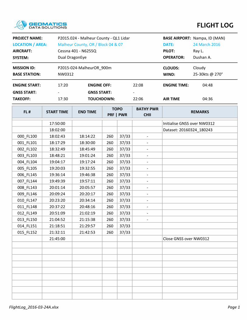
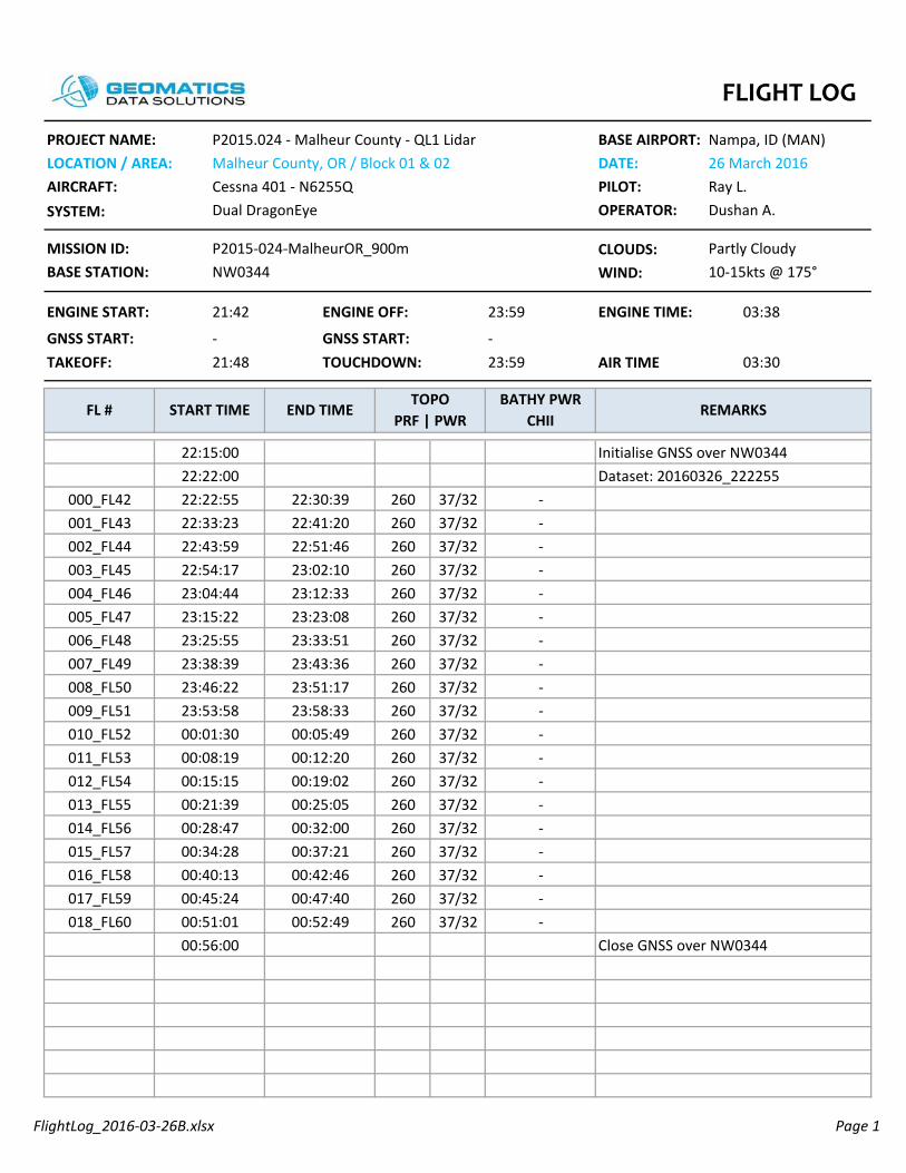
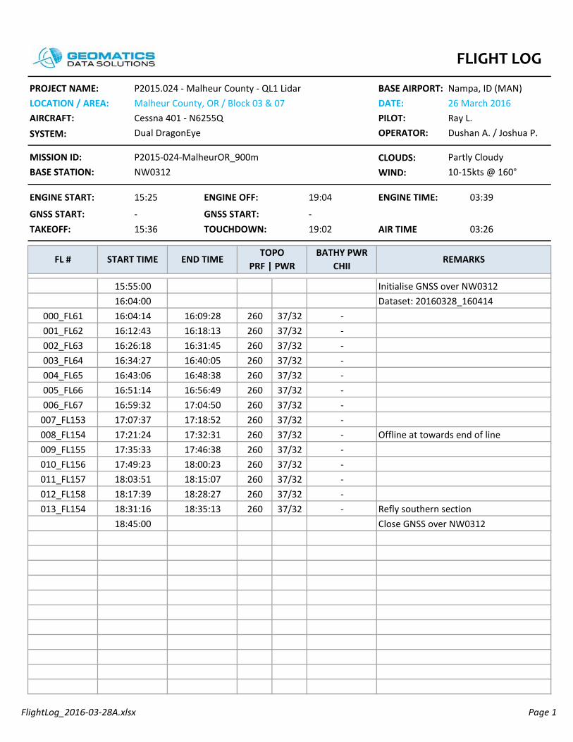
Section 6: LiDAR Acquisition Flight Logs This section contains the Flight Log(s) covering the project. Flight Logs list mission specific details such as crew members, airports, weather conditions, real time PDOP values and document any issues encountered during the mission. Flight Logs are filled out by the sensor operator during the acquisition flight.

FlightLog_2016-03-23A.xlsx Page 1
CLOUDS:WIND:
260 37/33260 37/33260 37/33
260 37/33260 37/33260 37/33260 37/33260 37/33260 37/33260 37/33260 37/33260 37/33260 37/33260 37/33260 37/33260 37/33260 37/33260 37/33260 37/33260 37/33260 37/33260 37/33
BATHY PWR CHII
START TIME END TIMETOPO
PRF | PWRREMARKS
03:49TAKEOFF: TOUCHDOWN:
Nampa, ID (MAN)23 March 2016Ray L.
Dual DragonEye OPERATOR:
15:35 ENGINE OFF:
GNSS START:
Johan E.
P2015-024-MalheurOR_900mNW0312
Cloudy15kts @ 240°
GNSS START:19:3315:44
-
PROJECT NAME:LOCATION / AREA:AIRCRAFT: PILOT:SYSTEM:
P2015.024 - Malheur County - QL1 LidarMalheur County, OR / Block 04Cessna 401 - N6255Q
BASE AIRPORT:DATE:
19:35
MISSION ID:BASE STATION:
ENGINE START: 04:00
Initialise GNSS over NW031215:55:00
- Laser Test
ENGINE TIME:
AIR TIME-
FL #
- Laser Test
001_FL83
000_FL143001_FL143
16:11:0016:11:4816:12:08
16:32:16 -16:22:27 -
16:11:5916:13:21
Dataset: 20160323_161148
002_FL84 16:42:16003_FL85 16:52:01
--
002_FL143 16:13:33Dataset: 20160323_161555
16:15:5516:25:4116:35:1816:45:35
- Abort due to clouds
000_FL82
16:13:31
004_FL81 17:00:46005_FL80 17:10:3817:04:22
--
16:54:11
006_FL79 17:19:40007_FL78 17:28:37
17:13:1417:22:22
--
008_FL77 17:37:47009_FL76 17:46:24
17:31:3317:40:14
--
010_FL75 17:56:53011_FL74 18:05:32
17:50:4317:59:31
--
012_FL73 18:14:35013_FL72 18:23:30
18:08:3218:17:40
--
014_FL71 18:32:24015_FL70 18:40:39
18:26:2718:34:58
--
016_FL69 18:49:22017_FL68 18:58:05
18:43:3518:52:16
--
018_FL85 19:09:1719:01:4019:05:00
- ReflyClose GNSS over NW0312
FLIGHT LOG

FlightLog_2016-03-23B.xlsx Page 1
CLOUDS:WIND:
260 37/33260 37/33260 37/33260 37/33260 37/33260 37/33260 37/33260 37/33260 37/33260 37/33260 37/33260 37/33260 37/33260 37/33
BATHY PWR CHII
START TIME END TIMETOPO
PRF | PWRREMARKS
03:45TAKEOFF: TOUCHDOWN:
Nampa, ID (MAN)23 March 2016Ray L.
Dual DragonEye OPERATOR:
21:35 ENGINE OFF:
GNSS START:
Dushan A.
P2015-024-MalheurOR_900mNW0312
Cloudy15kts @ 240°
GNSS START:01:2621:41
-
PROJECT NAME:LOCATION / AREA:AIRCRAFT: PILOT:SYSTEM:
P2015.024 - Malheur County - QL1 LidarMalheur County, OR / Block 04Cessna 401 - N6255Q
BASE AIRPORT:DATE:
01:28
MISSION ID:BASE STATION:
ENGINE START: 03:53
Initialise GNSS over NW031222:00:00
-
ENGINE TIME:
AIR TIME-
FL #
-
005_FL91
000_FL86001_FL87
22:11:0022:11:4322:22:02
23:16:32 -23:04:48 -
22:19:1622:30:09
Dataset: 20160323_221143
006_FL92 23:28:48007_FL93 23:41:21
--
002_FL88 22:41:12003_FL89 22:53:04 -22:44:29
22:55:5223:07:2423:19:1823:31:41
-
004_FL90
22:32:57
008_FL94 23:53:43009_FL95 00:06:4623:56:27
--
23:43:31
010_FL96 00:19:33011_FL97 00:33:51
00:09:1200:22:42
--
012_FL98 00:47:22013_FL99 01:01:48
00:36:0700:50:14
--
01:55:00 Close GNSS over NW0312
FLIGHT LOG
FlightLog_2016-03-24A.xlsx Page 1
CLOUDS:WIND:
260 37/33260 37/33260 37/33260 37/33260 37/33260 37/33260 37/33260 37/33260 37/33260 37/33260 37/33260 37/33260 37/33260 37/33260 37/33260 37/33
BATHY PWR CHII
START TIME END TIMETOPO
PRF | PWRREMARKS
04:36TAKEOFF: TOUCHDOWN:
Nampa, ID (MAN)24 March 2016Ray L.
Dual DragonEye OPERATOR:
17:20 ENGINE OFF:
GNSS START:
Dushan A.
P2015-024-MalheurOR_900mNW0312
Cloudy25-30kts @ 270°
GNSS START:22:0617:30
-
PROJECT NAME:LOCATION / AREA:AIRCRAFT: PILOT:SYSTEM:
P2015.024 - Malheur County - QL1 LidarMalheur County, OR / Block 04 & 07Cessna 401 - N6255Q
BASE AIRPORT:DATE:
22:08
MISSION ID:BASE STATION:
ENGINE START: 04:48
Initialise GNSS over NW031217:50:00
-
ENGINE TIME:
AIR TIME-
FL #
-
005_FL105
000_FL100001_FL101
18:02:0018:02:4318:17:29
19:32:55 -19:17:24 -
18:14:2218:30:00
Dataset: 20160324_180243
006_FL145 19:46:38007_FL144 19:57:11
--
002_FL102 18:45:49003_FL103 19:01:24 -18:48:21
19:04:1719:20:0319:36:1419:49:39
-
004_FL104
18:32:49
008_FL143 20:05:57009_FL146 20:20:1720:09:24
--
20:01:14
010_FL147 20:34:14011_FL148 20:48:16
20:23:2020:37:22
--
012_FL149 21:02:19013_FL150 21:15:38
20:51:0921:04:52
--
014_FL151 21:29:57015_FL152 21:42:53
21:18:5121:32:1121:45:00 Close GNSS over NW0312
FLIGHT LOG

FlightLog_2016-03-25A.xlsx Page 1
CLOUDS:WIND:
260 37/33260 37/33260 37/33260 37/33260 37/33260 37/33260 37/33260 37/33260 37/33260 37/33260 37/33260 37/33260 37/33260 37/33260 37/33260 37/33260 37/33260 37/33260 37/33260 37/33260 37/33020_FL41 18:35:0518:27:40
18:40:00-
Close GNSS over NW0344
018_FL39 18:14:18019_FL40 18:24:54
18:06:5518:17:24
--
016_FL37 17:54:05017_FL38 18:04:09
17:46:4717:56:44
--
014_FL35 17:33:44015_FL36 17:44:06
17:26:2217:36:35
--
012_FL33 17:13:17013_FL34 17:23:35
17:05:4217:16:08
--
010_FL31 16:52:02011_FL32 17:02:30
16:44:5516:55:11
--
008_FL29 16:32:10009_FL30 16:42:0616:35:01
--
16:25:04
006_FL27 16:12:50007_FL28 16:22:37
--
002_FL23 15:34:44003_FL24 15:44:05 -15:37:35
15:47:0915:56:3016:05:5416:15:35
-
004_FL25
15:28:21-
005_FL26
000_FL21001_FL22
15:09:0015:09:1615:18:43
16:03:09 -15:53:42 -
15:15:3115:25:01
Dataset: 20160325_150916Initialise GNSS over NW034415:00:00
-
ENGINE TIME:
AIR TIME-
FL #
10-15kts @ 300°
GNSS START:19:0214:36
-
PROJECT NAME:LOCATION / AREA:AIRCRAFT: PILOT:SYSTEM:
P2015.024 - Malheur County - QL1 LidarMalheur County, OR / Block 01Cessna 401 - N6255Q
BASE AIRPORT:DATE:
19:03
MISSION ID:BASE STATION:
ENGINE START: 04:37
BATHY PWR CHII
START TIME END TIMETOPO
PRF | PWRREMARKS
04:26TAKEOFF: TOUCHDOWN:
Nampa, ID (MAN)25 March 2016Ray L.
Dual DragonEye OPERATOR:
14:26 ENGINE OFF:
GNSS START:
Dushan A.
P2015-024-MalheurOR_900mNW0344
Partly Cloudy
FLIGHT LOG

FlightLog_2016-03-26A.xlsx Page 1
CLOUDS:WIND:
260 37/32260 37/32260 37/32260 37/32260 37/32260 37/32260 37/32260 37/32260 37/32260 37/32260 37/32260 37/32260 37/32260 37/32260 37/32260 37/32260 37/32260 37/32260 37/32260 37/32
BATHY PWR CHII
START TIME END TIMETOPO
PRF | PWRREMARKS
04:28TAKEOFF: TOUCHDOWN:
Nampa, ID (MAN)26 March 2016Ray L.
Dual DragonEye OPERATOR:
15:31 ENGINE OFF:
GNSS START:
Dushan A.
P2015-024-MalheurOR_900mNW0344
Partly Cloudy10-15kts @ 160°
GNSS START:20:1215:44
-
PROJECT NAME:LOCATION / AREA:AIRCRAFT: PILOT:SYSTEM:
P2015.024 - Malheur County - QL1 LidarMalheur County, OR / Block 01Cessna 401 - N6255Q
BASE AIRPORT:DATE:
20:14
MISSION ID:BASE STATION:
ENGINE START: 04:43
Initialise GNSS over NW034416:10:00
-
ENGINE TIME:
AIR TIME-
FL #
-
005_FL15
000_FL20001_FL19
16:18:0016:18:0616:28:01
17:11:46 -17:00:32 -
16:18:0616:28:01
Dataset: 20160326_161806
006_FL14 17:22:52007_FL13 17:34:07
--
002_FL18 16:38:34003_FL17 16:49:27 -16:49:27
17:00:3217:11:4617:22:5217:34:07
-
004_FL16
16:38:34
008_FL12 17:45:13009_FL11 17:56:0617:56:06
--
17:45:13
010_FL10 18:07:06011_FL9 18:18:03
18:07:0618:18:03
--
012_FL8 18:28:59013_FL7 18:39:59
18:28:5918:39:59
--
014_FL6 18:50:26015_FL5 19:01:11
18:50:2619:01:11
--
016_FL4 19:11:26017_FL3 19:21:38
19:11:2619:21:38
--
018_FL2 19:31:22019_FL1 19:40:26
19:31:2219:40:26
--
19:50:00 Close GNSS over NW0344
FLIGHT LOG
FlightLog_2016-03-26B.xlsx Page 1
CLOUDS:WIND:
260 37/32260 37/32260 37/32260 37/32260 37/32260 37/32260 37/32260 37/32260 37/32260 37/32260 37/32260 37/32260 37/32260 37/32260 37/32260 37/32260 37/32260 37/32260 37/32018_FL60 00:52:4900:51:01
00:56:00-
Close GNSS over NW0344
016_FL58 00:42:46017_FL59 00:47:40
00:40:1300:45:24
--
014_FL56 00:32:00015_FL57 00:37:21
00:28:4700:34:28
--
012_FL54 00:19:02013_FL55 00:25:05
00:15:1500:21:39
--
010_FL52 00:05:49011_FL53 00:12:20
00:01:3000:08:19
--
008_FL50 23:51:17009_FL51 23:58:3323:53:58
--
23:46:22
006_FL48 23:33:51007_FL49 23:43:36
--
002_FL44 22:51:46003_FL45 23:02:10 -22:54:17
23:04:4423:15:2223:25:5523:38:39
-
004_FL46
22:43:59-
005_FL47
000_FL42001_FL43
22:22:0022:22:5522:33:23
23:23:08 -23:12:33 -
22:30:3922:41:20
Dataset: 20160326_222255Initialise GNSS over NW034422:15:00
-
ENGINE TIME:
AIR TIME-
FL #
10-15kts @ 175°
GNSS START:23:5921:48
-
PROJECT NAME:LOCATION / AREA:AIRCRAFT: PILOT:SYSTEM:
P2015.024 - Malheur County - QL1 LidarMalheur County, OR / Block 01 & 02Cessna 401 - N6255Q
BASE AIRPORT:DATE:
23:59
MISSION ID:BASE STATION:
ENGINE START: 03:38
BATHY PWR CHII
START TIME END TIMETOPO
PRF | PWRREMARKS
03:30TAKEOFF: TOUCHDOWN:
Nampa, ID (MAN)26 March 2016Ray L.
Dual DragonEye OPERATOR:
21:42 ENGINE OFF:
GNSS START:
Dushan A.
P2015-024-MalheurOR_900mNW0344
Partly Cloudy
FLIGHT LOG
FlightLog_2016-03-28A.xlsx Page 1
CLOUDS:WIND:
260 37/32260 37/32260 37/32260 37/32260 37/32260 37/32260 37/32260 37/32260 37/32260 37/32260 37/32260 37/32260 37/32260 37/32
18:45:00 Close GNSS over NW0312
012_FL158 18:28:27013_FL154 18:35:13
18:17:3918:31:16
-- Refly southern section
010_FL156 18:00:23011_FL157 18:15:07
17:49:2318:03:51
--
008_FL154 17:32:31009_FL155 17:46:3817:35:33
- Offline at towards end of line-
17:21:24
006_FL67 17:04:50007_FL153 17:18:52
--
002_FL63 16:31:45003_FL64 16:40:05 -16:34:27
16:43:0616:51:1416:59:3217:07:37
-
004_FL65
16:26:18-
005_FL66
000_FL61001_FL62
16:04:0016:04:1416:12:43
16:56:49 -16:48:38 -
16:09:2816:18:13
Dataset: 20160328_160414Initialise GNSS over NW031215:55:00
-
ENGINE TIME:
AIR TIME-
FL #
10-15kts @ 160°
GNSS START:19:0215:36
-
PROJECT NAME:LOCATION / AREA:AIRCRAFT: PILOT:SYSTEM:
P2015.024 - Malheur County - QL1 LidarMalheur County, OR / Block 03 & 07Cessna 401 - N6255Q
BASE AIRPORT:DATE:
19:04
MISSION ID:BASE STATION:
ENGINE START: 03:39
BATHY PWR CHII
START TIME END TIMETOPO
PRF | PWRREMARKS
03:26TAKEOFF: TOUCHDOWN:
Nampa, ID (MAN)26 March 2016Ray L.
Dual DragonEye OPERATOR:
15:25 ENGINE OFF:
GNSS START:
Dushan A. / Joshua P.
P2015-024-MalheurOR_900mNW0312
Partly Cloudy
FLIGHT LOG
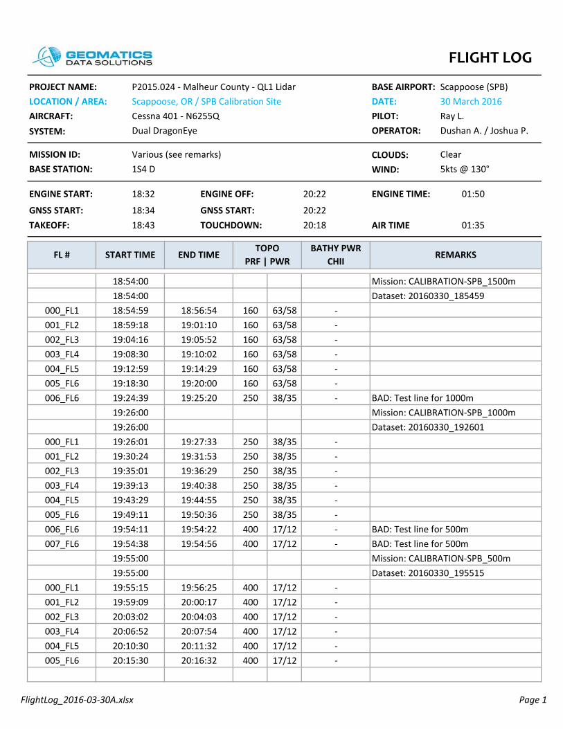
FlightLog_2016-03-30A.xlsx Page 1
CLOUDS:WIND:
160 63/58160 63/58160 63/58160 63/58160 63/58160 63/58250 38/35
250 38/35250 38/35250 38/35250 38/35250 38/35250 38/35400 17/12400 17/12
400 17/12400 17/12400 17/12400 17/12400 17/12400 17/12
Dushan A. / Joshua P.
Various (see remarks)1S4 D
ClearMISSION ID:BASE STATION:
ENGINE START: 01:50
BATHY PWR CHII
START TIME END TIMETOPO
PRF | PWRREMARKS
01:35TAKEOFF: TOUCHDOWN:
Scappoose (SPB)30 March 2016Ray L.
Dual DragonEye OPERATOR:
18:32 ENGINE OFF:
GNSS START:
PROJECT NAME:LOCATION / AREA:AIRCRAFT: PILOT:SYSTEM:
P2015.024 - Malheur County - QL1 LidarScappoose, OR / SPB Calibration SiteCessna 401 - N6255Q
BASE AIRPORT:DATE:
ENGINE TIME:
AIR TIME20:22
FL #
5kts @ 130°
GNSS START:20:1818:43
18:34
20:22
18:54:0018:54:00
19:10:02 -19:05:52 -
Mission: CALIBRATION-SPB_1500m
004_FL5 19:14:29005_FL6 19:20:00
--
000_FL1 18:56:54001_FL2 19:01:10 -18:59:18
19:04:1619:08:3019:12:5919:18:30
-
002_FL3
18:54:59
003_FL4
006_FL6 19:25:2019:26:00
- BAD: Test line for 1000mMission: CALIBRATION-SPB_1000m
19:24:39
000_FL1 19:27:3319:26:0019:26:01
Dataset: 20160330_192601-
001_FL2 19:31:53002_FL3 19:36:29
19:30:2419:35:01
--
003_FL4 19:40:38004_FL5 19:44:55
19:39:1319:43:29
--
005_FL6 19:50:36006_FL6 19:54:22
19:49:1119:54:11
-- BAD: Test line for 500m
007_FL6 19:54:5619:54:3819:55:00
- BAD: Test line for 500mMission: CALIBRATION-SPB_500m
000_FL1 19:56:2519:55:0019:55:15
Dataset: 20160330_195515-
001_FL2 20:00:17002_FL3 20:04:03
19:59:0920:03:02
--
003_FL4 20:07:54004_FL5 20:11:32
20:06:5220:10:30
--
005_FL6 20:16:3220:15:30 -
Dataset: 20160330_185459
FLIGHT LOG

FlightLog_2016-03-31A.xlsx Page 1
CLOUDS:WIND:
260 37 / 32260 37 / 32260 37 / 32260 37 / 32260 37 / 32260 37 / 32260 37 / 32260 37 / 32260 37 / 32260 37 / 32260 37 / 32260 37 / 32260 37 / 32260 37 / 32
BATHY PWR CHII
START TIME END TIMETOPO
PRF | PWRREMARKS
04:10TAKEOFF: TOUCHDOWN:
Scappoose (SPB)31 March 2016Ray L.
Dual DragonEye OPERATOR:
14:41 ENGINE OFF:
GNSS START:
Joshua P.
P2015-024-MalheurOR_900mNW0312
Clear
PROJECT NAME:LOCATION / AREA:AIRCRAFT: PILOT:SYSTEM:
P2015.024 - Malheur County - QL1 LidarMalheur County, OR / Block 7Cessna 401 - N6255Q
BASE AIRPORT:DATE:
MISSION ID:BASE STATION:
AIR TIME-
FL #
8kts @ 350°
GNSS START:19:0214:52
-
19:03 ENGINE TIME:ENGINE START: 04:22
001_FL163
15:21:1215:35:09
16:42:57 N/A16:28:59 N/A
15:32:2515:46:18
N/A000_FL159001_FL160001_FL161
16:57:20
001_FL169
17:11:16N/AN/A
001_FL164
16:00:40
001_FL165
16:14:39 N/A16:03:2616:17:3816:31:4816:45:5917:00:09
N/A
001_FL166
15:49:23
001_FL167
001_FL162
17:26:11
001_FL171
17:40:1617:28:55N/AN/A
17:14:35001_FL168
17:54:4118:08:42
17:43:1517:57:14
N/AN/A001_FL170
18:23:1318:36:40
18:11:5118:25:58
N/AN/A001_FL172
18:39:00 Close GNSS over NW0312
N/A
15:13:37 Initialize GNSS over NW031215:19:00 Dataset: 20160401_071239
FLIGHT LOG

FlightLog_2016-03-31B.xlsx Page 1
CLOUDS:WIND:
260 37 / 32260 37 / 32260 37 / 32260 37 / 32260 37 / 32260 37 / 32260 37 / 32260 37 / 32260 37 / 32260 37 / 32260 37 / 32260 37 / 32260 37 / 32260 37 / 32260 37 / 32260 37 / 32
BATHY PWR CHII
START TIME END TIMETOPO
PRF | PWRREMARKS
04:12TAKEOFF: TOUCHDOWN:
Scappoose (SPB)31 March 2016Ray L.
Dual DragonEye OPERATOR:
20:58 ENGINE OFF:
GNSS START:
Joshua P.
P2015-024-MalheurOR_900mNW0588
Clear
PROJECT NAME:LOCATION / AREA:AIRCRAFT: PILOT:SYSTEM:
P2015.024 - Malheur County - QL1 LidarMalheur County, OR / Block 7Cessna 401 - N6255Q
BASE AIRPORT:DATE:
MISSION ID:BASE STATION:
AIR TIME-
FL #
8kts @ 350°
GNSS START:01:1521:03
-
01:16 ENGINE TIME:ENGINE START: 04:18
004_FL177
21:28:4121:42:27
22:43:4422:31:37
21:39:5321:53:18
000_FL173001_FL174002_FL175
22:56:45
010_FL183
23:08:39
005_FL178
22:06:49
006_FL179
22:18:5722:09:1622:22:0022:34:1122:46:4922:59:16007_FL180
21:56:28
008_FL181
003_FL176
23:20:57
001_FL185
23:32:5023:23:1823:11:07
009_FL18223:45:3300:01:40
23:35:4523:52:02000_FL184
00:14:2800:27:06
00:04:2800:17:12002_FL186
00:40:13003_FL18700:52:53
00:29:5200:42:39
Close GNSS over NW0588
004_FL188
00:56:00
21:20:00 Initialize GNSS over NW0588Dataset:
FLIGHT LOG

FlightLog_2016-04-01A.xlsx Page 1
CLOUDS:WIND:
BATHY PWR CHII
START TIME END TIMETOPO
PRF | PWRREMARKS
04:10TAKEOFF: TOUCHDOWN:
Scappoose (SPB)31 March 2016Ray L.
Dual DragonEye OPERATOR:
18:35 ENGINE OFF:
GNSS START:
Joshua P.
P2015-024-MalheurOR_900mNW0588
Ptly Cldy
PROJECT NAME:LOCATION / AREA:AIRCRAFT: PILOT:SYSTEM:
P2015.024 - Malheur County - QL1 LidarMalheur County, OR / Block Cessna 401 - N6255Q
BASE AIRPORT:DATE:
MISSION ID:BASE STATION:
AIR TIME-
FL #
5kts @ 140°
GNSS START:22:5818:48
-
23:03 ENGINE TIME:ENGINE START: 04:28
005_FL194
19:32:4119:45:56
20:50:3820:37:14
19:43:2819:56:47
001_FL190002_FL191003_FL192
21:03:59
011_FL200
21:17:44
006_FL195
20:10:10
007_FL196
20:23:3620:12:3320:26:0320:39:4220:52:5721:06:40008_FL197
19:59:06
009_FL198
004_FL193
21:31:03
013_FL243
21:44:3621:33:4021:20:08
010_FL19921:58:0922:11:19
21:46:4722:00:33012_FL201
22:21:01
22:31:30
22:16:36
22:28:28015_FL221014_FL222 22:23:08 22:25:57
22:34:00 Close GNSS over NW0588
19:07:00 Initialize GNSS over NW0588000_FL189 19:19:38 19:30:03 Dataset:
FLIGHT LOG
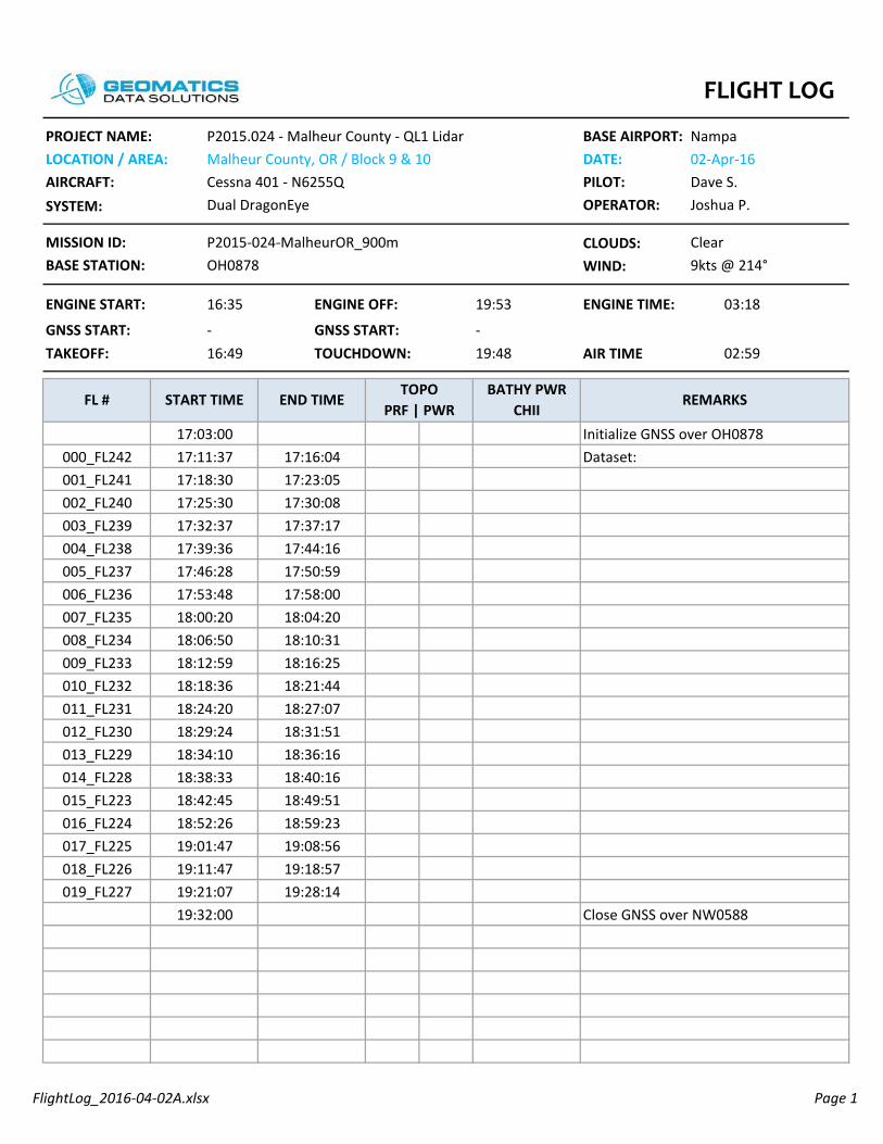
FlightLog_2016-04-02A.xlsx Page 1
CLOUDS:WIND:
BATHY PWR CHII
START TIME END TIMETOPO
PRF | PWRREMARKS
02:59TAKEOFF: TOUCHDOWN:
Nampa02-Apr-16Dave S.
Dual DragonEye OPERATOR:
16:35 ENGINE OFF:
GNSS START:
Joshua P.
P2015-024-MalheurOR_900mOH0878
Clear
PROJECT NAME:LOCATION / AREA:AIRCRAFT: PILOT:SYSTEM:
P2015.024 - Malheur County - QL1 LidarMalheur County, OR / Block 9 & 10Cessna 401 - N6255Q
BASE AIRPORT:DATE:
MISSION ID:BASE STATION:
AIR TIME-
FL #
9kts @ 214°
GNSS START:19:4816:49
-
19:53 ENGINE TIME:ENGINE START: 03:18
005_FL237
17:18:3017:25:30
17:58:0017:50:59
17:23:0517:30:08
001_FL241002_FL240003_FL239
18:04:20
011_FL231
18:10:31
006_FL236
17:37:17
007_FL235
17:44:1617:39:3617:46:2817:53:4818:00:2018:06:50008_FL234
17:32:37
009_FL233
004_FL238
18:16:25
013_FL229
18:21:4418:18:3618:12:59
010_FL23218:27:0718:31:51
18:24:2018:29:24012_FL230
18:36:1618:34:10
19:32:00 Close GNSS over NW0588
016_FL224 18:52:26 18:59:23
17:03:00 Initialize GNSS over OH0878000_FL242 17:11:37 17:16:04 Dataset:
014_FL228 18:38:33 18:40:16015_FL223 18:42:45 18:49:51
017_FL225 19:01:47 19:08:56018_FL226 19:11:47 19:18:57019_FL227 19:21:07 19:28:14
FLIGHT LOG
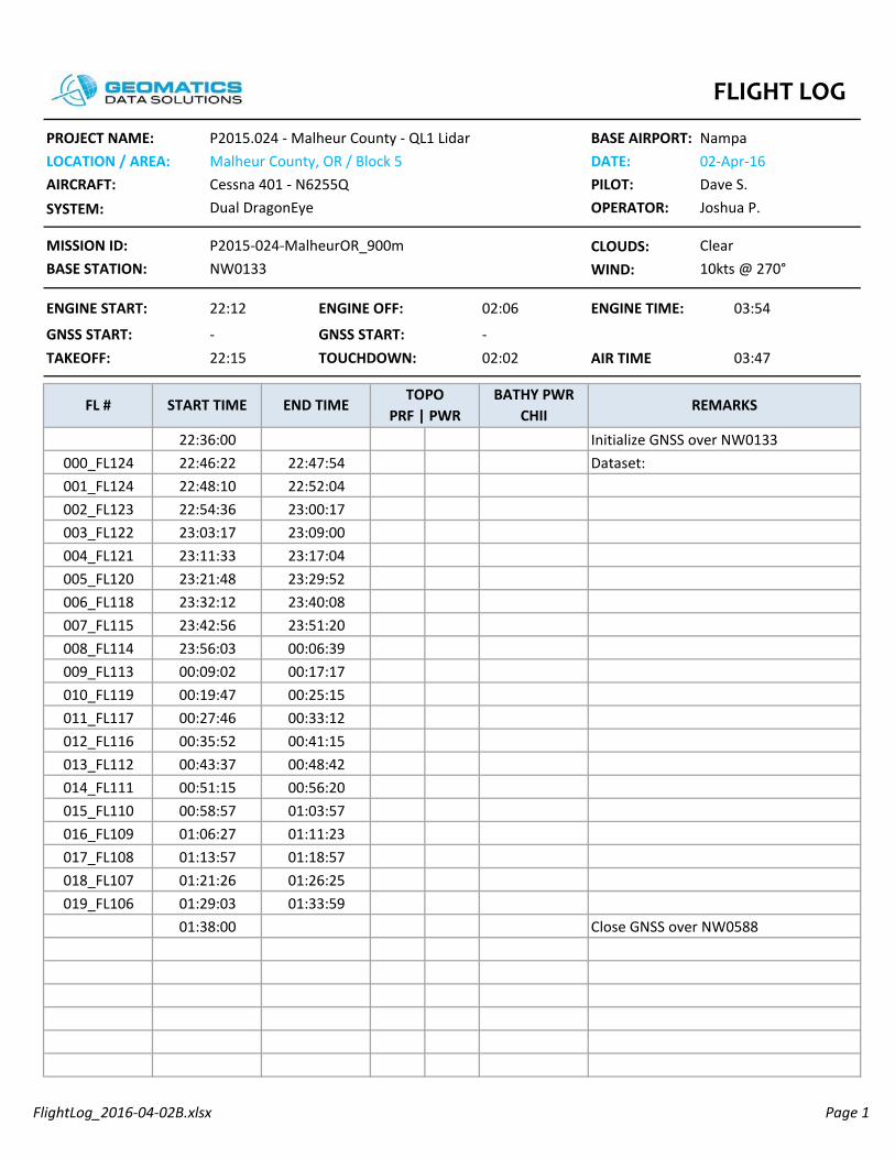
FlightLog_2016-04-02B.xlsx Page 1
CLOUDS:WIND:
BATHY PWR CHII
START TIME END TIMETOPO
PRF | PWRREMARKS
03:47TAKEOFF: TOUCHDOWN:
Nampa02-Apr-16Dave S.
Dual DragonEye OPERATOR:
22:12 ENGINE OFF:
GNSS START:
Joshua P.
P2015-024-MalheurOR_900mNW0133
Clear
PROJECT NAME:LOCATION / AREA:AIRCRAFT: PILOT:SYSTEM:
P2015.024 - Malheur County - QL1 LidarMalheur County, OR / Block 5Cessna 401 - N6255Q
BASE AIRPORT:DATE:
MISSION ID:BASE STATION:
AIR TIME-
FL #
10kts @ 270°
GNSS START:02:0222:15
-
02:06 ENGINE TIME:ENGINE START: 03:54
005_FL120
22:48:1022:54:36
23:40:0823:29:52
22:52:0423:00:17
001_FL124002_FL123003_FL122
23:51:20
011_FL117
00:06:39
006_FL118
23:09:00
007_FL115
23:17:0423:11:3323:21:4823:32:1223:42:5623:56:03008_FL114
23:03:17
009_FL113
004_FL121
00:17:17
013_FL112
00:25:1500:19:4700:09:02
010_FL11900:33:1200:41:15
00:27:4600:35:52012_FL116
00:48:4200:43:37
01:38:00 Close GNSS over NW0588
016_FL109 01:06:27 01:11:23
22:36:00 Initialize GNSS over NW0133000_FL124 22:46:22 22:47:54 Dataset:
014_FL111 00:51:15 00:56:20015_FL110 00:58:57 01:03:57
017_FL108 01:13:57 01:18:57018_FL107 01:21:26 01:26:25019_FL106 01:29:03 01:33:59
FLIGHT LOG

FlightLog_2016-04-03A.xlsx Page 1
CLOUDS:WIND:
017_FL140 17:55:33 17:58:12 refly due to snow
refly due to snow018_FL141 18:00:55 18:03:20 refly due to snow019_FL142 18:05:37 18:08:23
014_FL137 17:39:46 17:42:36 refly due to snow015_FL138 17:44:51 17:47:41 refly due to snow016_FL139 17:50:30 17:53:15 refly due to snow
16:02:00 Initialize GNSS over NW0133000_FL124 16:12:30 16:13:02 Dataset: 20160403_161230 reject
refly due to snow
18:12:00 Close GNSS over NW0588
17:14:50
013_FL136
17:20:3817:17:24refly due to snowrefly due to snow
17:11:35010_FL133
17:26:1617:31:52
17:22:5917:28:35
refly due to snowrefly due to snow012_FL135
17:37:0317:34:11 refly due to snow
17:03:04
011_FL134
17:08:53refly due to snowrefly due to snow
006_FL129
16:40:40
007_FL130
16:46:16 refly due to snow16:43:0916:48:4216:54:2117:00:0117:05:46
refly due to snow
008_FL131
16:37:33
009_FL132
004_FL127005_FL128
16:20:0716:32:03
16:57:25 refly due to snow16:51:55 refly due to snow
16:25:3516:35:15
001_FL124002_FL125003_FL126
MISSION ID:BASE STATION:
AIR TIME-
FL #
12kts @ 273°
GNSS START:18:3515:40
-
18:39 ENGINE TIME:ENGINE START: 03:05
PROJECT NAME:LOCATION / AREA:AIRCRAFT: PILOT:SYSTEM:
P2015.024 - Malheur County - QL1 LidarMalheur County, OR / Block 6Cessna 401 - N6255Q
BASE AIRPORT:DATE:
BATHY PWR CHII
START TIME END TIMETOPO
PRF | PWRREMARKS
02:55TAKEOFF: TOUCHDOWN:
Nampa03-Apr-16Dave S.
Dual DragonEye OPERATOR:
15:34 ENGINE OFF:
GNSS START:
Joshua P.
P2015-024-MalheurOR_900mNW0133
Clear
FLIGHT LOG
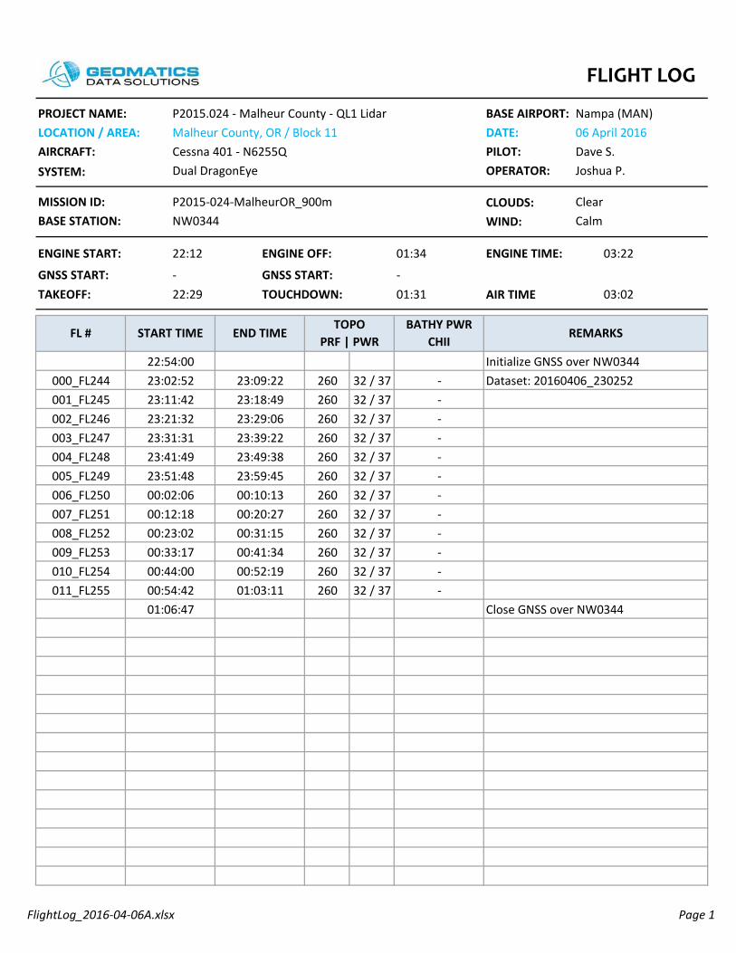
FlightLog_2016-04-06A.xlsx Page 1
CLOUDS:WIND:
260 32 / 37260 32 / 37260 32 / 37260 32 / 37260 32 / 37260 32 / 37260 32 / 37260 32 / 37260 32 / 37260 32 / 37260 32 / 37260 32 / 37
22:54:00 Initialize GNSS over NW0344000_FL244 23:02:52 23:09:22 - Dataset: 20160406_230252
00:41:3400:52:1900:44:00
--
00:33:17010_FL254
01:03:1100:54:4201:06:47
-Close GNSS over NW0344
00:20:27
011_FL255
00:31:15--
006_FL250
23:39:22
007_FL251
23:49:38 -23:41:4923:51:4800:02:0600:12:1800:23:02
-
008_FL252
23:31:31
009_FL253
004_FL248005_FL249
23:11:4223:21:32
00:10:13 -23:59:45 -
23:18:4923:29:06
-001_FL245002_FL246003_FL247
-
MISSION ID:BASE STATION:
AIR TIME-
FL #
Calm
GNSS START:01:3122:29
-
01:34 ENGINE TIME:ENGINE START: 03:22
PROJECT NAME:LOCATION / AREA:AIRCRAFT: PILOT:SYSTEM:
P2015.024 - Malheur County - QL1 LidarMalheur County, OR / Block 11Cessna 401 - N6255Q
BASE AIRPORT:DATE:
BATHY PWR CHII
START TIME END TIMETOPO
PRF | PWRREMARKS
03:02TAKEOFF: TOUCHDOWN:
Nampa (MAN)06 April 2016Dave S.
Dual DragonEye OPERATOR:
22:12 ENGINE OFF:
GNSS START:
Joshua P.
P2015-024-MalheurOR_900mNW0344
Clear
FLIGHT LOG
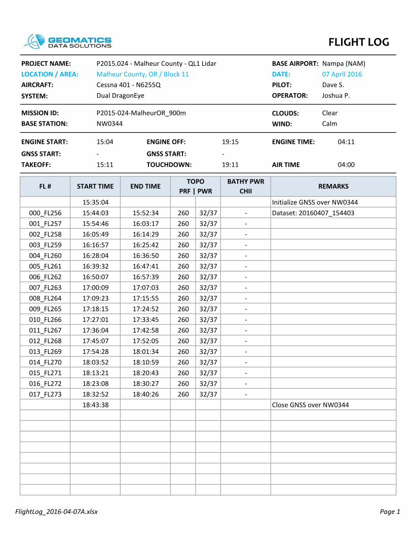
FlightLog_2016-04-07A.xlsx Page 1
CLOUDS:WIND:
260 32/37260 32/37260 32/37260 32/37260 32/37260 32/37260 32/37260 32/37260 32/37260 32/37260 32/37260 32/37260 32/37260 32/37260 32/37260 32/37260 32/37260 32/37017_FL273 18:32:52 18:40:26 -
18:43:38 Close GNSS over NW0344
014_FL270 18:03:52 18:10:59 -015_FL271 18:13:21 18:20:43 -016_FL272 18:23:08 18:30:27 -
15:35:04 Initialize GNSS over NW0344000_FL256 15:44:03 15:52:34 - Dataset: 20160407_154403
-
17:24:52
013_FL269
17:33:4517:27:01--
17:18:15010_FL266
17:42:5817:52:05
17:36:0417:45:07
--012_FL268
18:01:3417:54:28 -
17:07:03
011_FL267
17:15:55--
006_FL262
16:25:42
007_FL263
16:36:50 -16:28:0416:39:3216:50:0717:00:0917:09:23
-
008_FL264
16:16:57
009_FL265
004_FL260005_FL261
15:54:4616:05:49
16:57:39 -16:47:41 -
16:03:1716:14:29
-001_FL257002_FL258003_FL259
MISSION ID:BASE STATION:
AIR TIME-
FL #
Calm
GNSS START:19:1115:11
-
19:15 ENGINE TIME:ENGINE START: 04:11
PROJECT NAME:LOCATION / AREA:AIRCRAFT: PILOT:SYSTEM:
P2015.024 - Malheur County - QL1 LidarMalheur County, OR / Block 11Cessna 401 - N6255Q
BASE AIRPORT:DATE:
BATHY PWR CHII
START TIME END TIMETOPO
PRF | PWRREMARKS
04:00TAKEOFF: TOUCHDOWN:
Nampa (NAM)07 April 2016Dave S.
Dual DragonEye OPERATOR:
15:04 ENGINE OFF:
GNSS START:
Joshua P.
P2015-024-MalheurOR_900mNW0344
Clear
FLIGHT LOG

FlightLog_2016-04-07B.xlsx Page 1
CLOUDS:WIND:
260 32/37260 32/37260 32/37260 32/37260 32/37260 32/37260 32/37260 32/37260 32/37260 32/37260 32/37260 32/37
BATHY PWR CHII
START TIME END TIMETOPO
PRF | PWRREMARKS
03:15TAKEOFF: TOUCHDOWN:
Nampa (NAM)07 April 2016Dave S.
Dual DragonEye OPERATOR:
20:35 ENGINE OFF:
GNSS START:
Joshua P.
P2015-024-MalheurOR_900mNW0344
Clear
PROJECT NAME:LOCATION / AREA:AIRCRAFT: PILOT:SYSTEM:
P2015.024 - Malheur County - QL1 LidarMalheur County, OR / Block 11Cessna 401 - N6255Q
BASE AIRPORT:DATE:
MISSION ID:BASE STATION:
AIR TIME-
FL #
11knts. @ Az. 78
GNSS START:23:5520:40
-
23:59 ENGINE TIME:ENGINE START: 03:24
005_FL279
21:25:5721:36:11
22:25:19 -22:15:16 -
21:33:5221:43:58
-001_FL275002_FL276003_FL277
22:35:51
000_FL285
22:46:18--
006_FL280
21:54:31
007_FL281
22:04:48 -21:57:0122:07:1822:17:2922:27:5522:38:16
-
008_FL282
21:46:22
009_FL283
004_FL278
22:56:3423:07:0822:58:55
--
22:48:36010_FL284
23:19:0223:11:05 -
-
21:04:33 Initialize GNSS over NW0344000_FL274 21:15:53 21:23:29 - Dataset: 20160407_211553
23:26:00 Close GNSS over NW0344
FLIGHT LOG

FlightLog_2016-04-08A.xlsx Page 1
CLOUDS:WIND:
260 37 / 32260 37 / 32260 37 / 32260 37 / 32260 37 / 32260 37 / 32260 37 / 32260 37 / 32260 37 / 32260 37 / 32260 37 / 32260 37 / 32260 37 / 32260 37 / 32260 37 / 32260 37 / 32260 37 / 32260 37 / 32260 37 / 32260 37 / 32260 37 / 32260 37 / 32260 37 / 32
BATHY PWR CHII
START TIME END TIMETOPO
PRF | PWRREMARKS
04:31TAKEOFF: TOUCHDOWN:
Nampa08-Apr-16Dave S.
Dual DragonEye OPERATOR:
14:18 ENGINE OFF:
GNSS START:
Joshua P.
P2015-024-MalheurOR_900mNW0344
Clear
PROJECT NAME:LOCATION / AREA:AIRCRAFT: PILOT:SYSTEM:
P2015.024 - Malheur County - QL1 LidarMalheur County, OR / Block 6Cessna 401 - N6255Q
BASE AIRPORT:DATE:
MISSION ID:BASE STATION:
AIR TIME-
FL #
11knts. @ Az. 78
GNSS START:18:5714:26
-
19:01 ENGINE TIME:ENGINE START: 04:43
005_FL286
15:10:4515:20:59
16:09:01 -15:59:04 -
15:18:4015:28:54
-001_FL282002_FL283003_FL284
16:19:16
011_FL309
16:29:43--
006_FL287
15:39:04
007_FL288
15:48:56 -15:40:5815:51:0316:01:0116:11:1216:21:35
-
008_FL289
15:31:03
009_FL290
004_FL285
16:40:0916:48:3316:42:29
--
16:31:57010_FL308
16:57:0216:50:42 -
17:31:0717:16:0717:24:42
--015_FL313
17:39:37016_FL314
17:22:24014_FL312
17:48:1917:33:1317:41:44
--017_FL315
17:57:07018_FL31618:05:57
17:50:3617:59:18
--019_FL317
18:14:44020_FL31818:23:44
18:08:0718:17:01
--021_FL319
18:27:57022_FL309 18:25:5818:27:15
-Close GNSS over NW0344
-
14:49:28 Initialize GNSS over NW0344000_FL281 15:00:46 15:08:37 - Dataset: 20160408_150046
012_FL310 16:59:11 17:05:23 -013_FL311 17:07:34 17:13:59 -
FLIGHT LOG
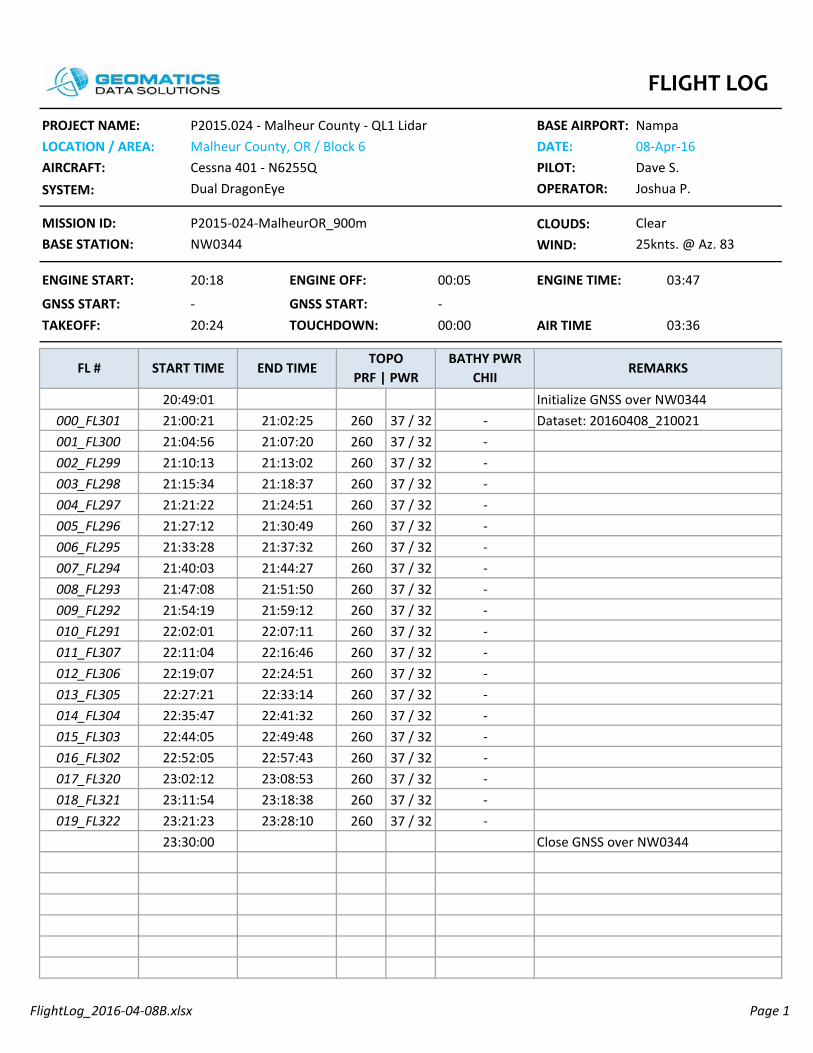
FlightLog_2016-04-08B.xlsx Page 1
CLOUDS:WIND:
260 37 / 32260 37 / 32260 37 / 32260 37 / 32260 37 / 32260 37 / 32260 37 / 32260 37 / 32260 37 / 32260 37 / 32260 37 / 32260 37 / 32260 37 / 32260 37 / 32260 37 / 32260 37 / 32260 37 / 32260 37 / 32260 37 / 32260 37 / 32
013_FL305 22:27:21 22:33:14 -
20:49:01 Initialize GNSS over NW0344000_FL301 21:00:21 21:02:25 - Dataset: 20160408_210021
012_FL306 22:19:07 22:24:51 -
-
23:30:00 Close GNSS over NW0344
-017_FL32023:18:38018_FL32123:28:10
23:11:5423:21:23
--019_FL322
015_FL30322:57:43016_FL302
22:41:32014_FL304
23:08:5322:52:0523:02:12
-
22:16:4622:11:04 -
22:49:4822:35:4722:44:05
--
21:59:1222:07:1122:02:01
--
21:54:19010_FL291
21:44:27
011_FL307
21:51:50--
006_FL295
21:18:37
007_FL294
21:24:51 -21:21:2221:27:1221:33:2821:40:0321:47:08
-
008_FL293
21:15:34
009_FL292
004_FL297005_FL296
21:04:5621:10:13
21:37:32 -21:30:49 -
21:07:2021:13:02
-001_FL300002_FL299003_FL298
MISSION ID:BASE STATION:
AIR TIME-
FL #
25knts. @ Az. 83
GNSS START:00:0020:24
-
00:05 ENGINE TIME:ENGINE START: 03:47
PROJECT NAME:LOCATION / AREA:AIRCRAFT: PILOT:SYSTEM:
P2015.024 - Malheur County - QL1 LidarMalheur County, OR / Block 6Cessna 401 - N6255Q
BASE AIRPORT:DATE:
BATHY PWR CHII
START TIME END TIMETOPO
PRF | PWRREMARKS
03:36TAKEOFF: TOUCHDOWN:
Nampa08-Apr-16Dave S.
Dual DragonEye OPERATOR:
20:18 ENGINE OFF:
GNSS START:
Joshua P.
P2015-024-MalheurOR_900mNW0344
Clear
FLIGHT LOG

FlightLog_2016-04-09A.xlsx Page 1
CLOUDS:WIND:
260 37 / 32260 37 / 32260 37 / 32260 37 / 32260 37 / 32260 37 / 32260 37 / 32260 37 / 32260 37 / 32260 37 / 32260 37 / 32260 37 / 32260 37 / 32260 37 / 32013_FL336 18:19:45 18:30:54 -
15:40:00 Initialize GNSS over NW0344000_FL323 15:49:58 15:57:07 - Dataset: 20160409_154958
012_FL335 18:06:20 18:17:01 -
-
18:34:30 Close GNSS over NW0344
17:38:0717:50:4717:40:43
--
17:28:16010_FL333
17:13:31
011_FL334
17:25:35--
006_FL329
17:16:06008_FL331009_FL332
18:03:4917:53:27 -
007_FL330
16:39:02 -16:30:4216:41:4116:52:4517:04:13
-16:20:11004_FL327005_FL328
17:01:40 -16:50:19 -
16:07:2916:17:35
-
16:28:14
001_FL324002_FL325003_FL326
MISSION ID:BASE STATION:
AIR TIME-
FL #
Calm
GNSS START:19:0215:15
-
19:04 ENGINE TIME:ENGINE START: 03:55
15:59:5916:09:52
PROJECT NAME:LOCATION / AREA:AIRCRAFT: PILOT:SYSTEM:
P2015.024 - Malheur County - QL1 LidarMalheur County, OR / Block 6Cessna 401 - N6255Q
BASE AIRPORT:DATE:
BATHY PWR CHII
START TIME END TIMETOPO
PRF | PWRREMARKS
03:47TAKEOFF: TOUCHDOWN:
Nampa09-Apr-16Dave S.
Dual DragonEye OPERATOR:
15:09 ENGINE OFF:
GNSS START:
Joshua P.
P2015-024-MalheurOR_900mNW0344
Clear
FLIGHT LOG

FlightLog_2016-06-08B.xlsx Page 1
CLOUDS:WIND:
250 36/35250 36/35250 36/35250 36/35250 36/35250 36/35
250 36/35250 36/35250 36/35250 36/35
400 16/14400 14/12400 14/12400 14/12400 14/12400 14/12
Dataset: 20160609_000930
005_FL6 01:19:0001:17:58 -
003_FL4 01:10:28004_FL5 01:14:19
01:09:2201:13:18
--
001_FL2 01:02:46002_FL3 01:06:49
01:01:3701:05:47
--
000_FL1 00:58:4600:57:0000:57:35
- Dataset: 20160609_005735-
003_FL4 00:53:2900:51:3100:57:00
-- Mission: CALIBRATION-SPB_500m
001_FL2 00:43:04002_FL3 00:48:21
00:41:1500:46:26
--
19:26:00 Mission: CALIBRATION-SPB_RCD30
000_FL1 00:38:2919:26:0000:36:40
Dataset: 20160609_003640-
004_FL5 00:28:23005_FL6 00:33:46
--
000_FL1 00:10:58001_FL2 00:15:05 -00:13:31
00:17:4600:22:0000:26:5700:32:14
-
002_FL3
00:09:30
003_FL4
18:54:0018:54:00
00:23:28 -00:19:17 -
Mission: CALIBRATION-SPB_1000m
AIR TIME01:23
FL #
10kts @ 275°
GNSS START:01:2023:59
23:49
01:28
PROJECT NAME:LOCATION / AREA:AIRCRAFT: PILOT:SYSTEM:
P2015.024 - Malheur County - QL1 LidarScappoose, OR / SPB Calibration SiteCessna 401 - N6255Q
BASE AIRPORT:DATE:
BATHY PWR CHII
START TIME END TIMETOPO
PRF | PWRREMARKS
01:21TAKEOFF: TOUCHDOWN:
Scappoose (SPB)08 June 2016Ray L.
Dual DragonEye OPERATOR:
23:46 ENGINE OFF:
GNSS START:
ENGINE TIME:
Dushan A. / Ben H.
Various (see remarks)1S4 D
CloudyMISSION ID:BASE STATION:
ENGINE START: 01:42
FLIGHT LOG

FlightLog_2016-06-09A.xlsx Page 1
CLOUDS:WIND:
160 60 / 59160 61 / 59160 61 / 59160 61 / 59160 61 / 59160 61 / 59
250 35 / 34250 35 / 33250 35 / 33250 35 / 33250 35 / 33250 35 / 33
400 15 / 14400 14 / 12400 14 / 12400 14 / 12400 14 / 12400 14 / 12
005_FL6 23:04:34 23:06:12 -
(MMD ahead of UTC) offset between MMD and UTC
005_FL6 23:34:0523:32:52 -Nore: Approximately 2 minute time
003_FL4 23:24:27004_FL5 23:28:35
23:23:1123:27:21
--
001_FL2 23:15:52002_FL3 23:20:09
23:14:3623:18:57
--
000_FL1 23:11:3223:10:17- Dataset: 20160609_231017-
003_FL4 22:55:2922:53:47 -
- Mission: CALIBRATION-MAN_500m
004_FL5 22:58:04 22:59:46 -
001_FL2 22:45:47002_FL3 22:50:51
22:44:0522:49:16
--
Mission: CALIBRATION-MAN_1000m
000_FL1 22:40:5822:39:10Dataset: 20160609_223910
-
004_FL5 22:29:06005_FL6 22:34:56
--
000_FL1 22:11:02001_FL2 22:15:30 -22:13:55
22:18:2622:23:1022:27:3722:33:30
-
002_FL3
22:09:28
003_FL4 22:24:35 -22:19:54 -
Mission: CALIBRATION-MAN_1500mDataset: 20160609_220928
MISSION ID:BASE STATION:
AIR TIME23:38
FL #
Calm
GNSS START:23:3522:00
21:49
23:43 ENGINE TIME:ENGINE START: 01:56
PROJECT NAME:LOCATION / AREA:AIRCRAFT: PILOT:SYSTEM:
P2015.024 - Malheur County - QL1 LidarNampa, ID / MAN Calibration SiteCessna 401 - N6255Q
BASE AIRPORT:DATE:
BATHY PWR CHII
START TIME END TIMETOPO
PRF | PWRREMARKS
01:35TAKEOFF: TOUCHDOWN:
Nampa (MAN)09-Jun-16Ray L.
Dual DragonEye OPERATOR:
21:47 ENGINE OFF:
GNSS START:
Ben H.
Various (see remarks)MAN1
Clear
FLIGHT LOG

FlightLog_2016-06-10A.xlsx Page 1
CLOUDS:WIND:
280 34 / 32280 35 / 32280 35 / 32280 35 / 32280 35 / 32280 35 / 32280 35 / 32280 35 / 32280 35 / 32280 35 / 32280 35 / 32280 35 / 32280 35 / 32280 35 / 32280 35 / 32280 35 / 32280 35 / 32280 35 / 32280 35 / 32280 35 / 32280 35 / 32280 35 / 32280 35 / 32280 35 / 32280 35 / 32280 35 / 32280 35 / 32
BATHY PWR CHII
START TIME END TIMETOPO
PRF | PWRREMARKS
03:50TAKEOFF: TOUCHDOWN:
Nampa (MAN)10-Jun-16Ray L.
Dual DragonEye OPERATOR:
14:11 ENGINE OFF:
GNSS START:
Ben H.
P2015-024-MalheurOR_900mNW0312
ClearMISSION ID:BASE STATION:
PROJECT NAME:LOCATION / AREA:AIRCRAFT: PILOT:SYSTEM:
P2015.024 - Malheur County - QL1 LidarMalheur County, OR / BL04, BL06, BL07, BL23Cessna 401 - N6255Q
BASE AIRPORT:DATE:
15kts @ 190°
GNSS START:18:2614:36
-
18:29 ENGINE TIME:ENGINE START: 04:18
15:41:57 - Forced stop warning at EOL15:37:2715:44:3115:51:49
AIR TIME-
FL #
15:20:4015:27:53
-
15:34:56
001_FL480002_FL481003_FL482
15:16:1315:23:2615:30:20
010_FL126
16:02:18
011_FL127
16:08:41- Block 4 reflight- Block 7 reflight
006_FL485
16:06:54008_FL487009_FL125
16:29:0116:25:45 -
007_FL486
004_FL483005_FL484
15:56:08 - Completed Block 23 reflights15:49:05
16:16:2816:22:4816:19:31
- Block 6-
16:13:08
16:00:28
16:48:3716:45:24 -014_FL13016:54:43015_FL13117:01:11
16:51:3316:57:49
--016_FL132
17:07:21017_FL13317:13:53
17:03:5917:10:29
--018_FL134
17:19:53019_FL13517:26:30
17:16:3917:23:30
--020_FL136
17:31:43021_FL13717:38:47
17:29:0017:35:42
--022_FL138
17:43:59023_FL13917:50:16
17:41:0417:47:26
--024_FL140
17:55:35025_FL14118:01:54
17:52:5717:59:06
-- Completed Block 6026_FL142
--
-
012_FL128 16:32:36 16:35:54 -013_FL129 16:39:05 16:42:22 -
14:59:20 Initialize GNSS over NW0312000_FL479 15:08:43 15:13:06 - Dataset: 20160610_150843, Block 23
FLIGHT LOG

FlightLog_2016-06-10A.xlsx Page 2
CLOUDS:WIND:
BATHY PWR CHII
START TIME END TIMETOPO
PRF | PWRREMARKS
03:50TAKEOFF: TOUCHDOWN:
Nampa (MAN)10-Jun-16Ray L.
Dual DragonEye OPERATOR:
14:11 ENGINE OFF:
GNSS START:
Ben H.
P2015-024-MalheurOR_900mNW0312
ClearMISSION ID:BASE STATION:
PROJECT NAME:LOCATION / AREA:AIRCRAFT: PILOT:SYSTEM:
P2015.024 - Malheur County - QL1 LidarMalheur County, OR / BL04, BL06, BL07, BL23Cessna 401 - N6255Q
BASE AIRPORT:DATE:
15kts @ 190°
GNSS START:18:2614:36
-
18:29 ENGINE TIME:ENGINE START: 04:18
AIR TIME-
FL #
FLIGHT LOG
18:05:00 Close GNSS over NW0312
Nore: Approximately 2 minute timeoffset between MMD and UTC(MMD ahead of UTC)

FlightLog_2016-06-10B.xlsx Page 1
CLOUDS:WIND:
280 34 / 32280 35 / 32280 35 / 32280 35 / 32280 35 / 32280 35 / 32280 35 / 32280 35 / 32280 35 / 32280 35 / 32280 35 / 32280 35 / 32280 35 / 32280 35 / 32280 35 / 32280 35 / 32280 35 / 32280 35 / 32280 35 / 32280 35 / 32280 35 / 32280 35 / 32
MISSION ID:BASE STATION:
AIR TIME-
Nampa (MAN)10-Jun-16Ray L.
Dual DragonEye OPERATOR:
20:15 ENGINE OFF:
GNSS START:
Ben H.
P2015-024-MalheurOR_900mNW0588
High clouds
PROJECT NAME:LOCATION / AREA:AIRCRAFT: PILOT:SYSTEM:
P2015.024 - Malheur County - QL1 LidarMalheur County, OR / BL08, BL27Cessna 401 - N6255Q
BASE AIRPORT:DATE:
21:14:19 -21:11:2021:17:3121:23:53
FL #
18kts @ 220°
GNSS START:23:1720:20
-
23:18 ENGINE TIME:ENGINE START: 03:03
BATHY PWR CHII
START TIME END TIMETOPO
PRF | PWRREMARKS
02:57TAKEOFF: TOUCHDOWN:
20:57:2821:02:54
- Block 8
21:08:35
001_FL222002_FL221003_FL220
20:54:2320:59:5821:05:41
010_FL213
21:33:03
011_FL212
21:38:22--
006_FL217
21:35:21008_FL215009_FL214
21:55:5121:52:43 -
007_FL216
004_FL219005_FL218
21:26:50 -21:20:39
21:43:5721:50:0521:46:46
--
21:40:50
21:29:59
22:14:1022:10:54 -014_FL20922:20:30015_FL20822:26:13
22:17:2122:23:02
--016_FL207
22:32:08017_FL20622:38:07
22:29:0222:35:05
--018_FL205
22:43:35019_FL20422:49:37
22:40:4222:46:44
--020_FL203
22:55:24021_FL202 22:52:39 - Complete Block 8Close GNSS over NW0588
Nore: Approximately 2 minute time
- Light to moderate turbulence,
offset between MMD and UTC(MMD ahead of UTC)
- difficult to maintain altitude
-
012_FL211 21:59:17 22:02:24 -013_FL210 22:05:02 22:08:25 -
14:59:20 Initialize GNSS over NW0588000_FL488 20:47:31 20:49:22 - Dataset: 20160610_204731, RF BL 27
FLIGHT LOG

FlightLog_2016-06-15A.xlsx Page 1
CLOUDS:WIND:
280 33280 33280 33280 33280 33
280 30
280 33280 33280 33280 33280 33280 33280 33
BATHY PWR CHII
START TIME END TIMETOPO
PRF | PWRREMARKS
02:14TAKEOFF: TOUCHDOWN:
Nampa (MAN)15-Jun-16Ray L.
Dual DragonEye OPERATOR:
13:54 ENGINE OFF:
GNSS START:
Dushan A.
P2015-024-MalheurOR_900mNW0588
CloudyMISSION ID:BASE STATION:
PROJECT NAME:LOCATION / AREA:AIRCRAFT: PILOT:SYSTEM:
P2015.024 - Malheur County - QL1 LidarMalheur County, OR / BL04, BL06, BL07, BL23Cessna 401 - N6255Q
BASE AIRPORT:DATE:
10kts @ 170°
GNSS START:16:1814:04
-
16:20 ENGINE TIME:ENGINE START: 02:26
14:49:58 -14:47:31
14:54:39
AIR TIME-
FL #
14:33:2514:39:02
-
14:44:30
001_FL490002_FL491003_FL492
14:30:4914:36:1314:41:46
004_FL493
-
005_FL481
15:14:29006_FL222007_FL494
15:36:1715:33:42 -
14:59:08 -
15:24:5115:30:1715:27:47
-15:22:10
15:51:3815:49:40 -
008_FL495009_FL496
15:17:30Block 08
-
012_FL49916:00:00 Close GNSS over NW0588
-
Block 23
-
010_FL497 15:39:15 15:41:37 -011_FL498 15:44:53 15:47:05 -
14:22:00 Initialize GNSS over NW0588000_FL489 14:25:44 14:28:17 - Dataset: 20160615_142827 (BL06)
FLIGHT LOG

FEMA HQ Malheur OR QL1 Lidar
United States Geological Survey Airborne LiDAR Report October 2016 7-1
Section 7: Final Deliverables The final lidar deliverables are listed below.
LAS v1.4 classified point cloud
LAS v1.4 raw unclassified point cloud flight line strips.
Hydro Breaklines as ESRI shapefile
Bridge Breaklines as ESRI shapefile
Digital Elevation Model in ERDAS .IMG format
8-bit intensity images in .TIF format
Tile Index provided as ESRI shapefile
Control Points provided as ESRI shapefile
FGDC compliant metadata per product in XML format
Lidar processing report in pdf format
Survey report in pdf format