airborne laser altimetry for strategic habitat ... · pdf filesolar radiation, and slope...
TRANSCRIPT
S patial data layers, predictive model outcomes, and GIS maps describing wildlife habitat
relationships are now standard tools for guiding wildlife management and monitoring, and for targeting conserva-tion actions in places where they have the greatest impact (Craighead and Convis 2013). Therefore, it’s not hard to imagine why airborne LiDAR has rapidly become one of the most highly desired geospatial technologies for natural resource management and planning.
LiDAR has quickly transitioned from a novel technology to a valuable and operational environmental data source that can characterize terrestrial and aquatic ecosystems in ways not easily imagined a decade ago (Evans et al. 2009). Of the variety of LiDAR systems, 3D point cloud data from airborne laser altimetry shows the greatest potential for wildlife studies. It is highly intuitive (i.e. x, y, z coordinates) and relatively easy to process into precisely quantified vertical and horizontal vegetation structure and
bare earth surfaces. These layers can then be used to inform best practices for maintaining wildlife populations and other valued ecosystem services, such as clean and consistent water supplies. LiDAR availability has also increased as federal, state, and local governments develop cooperative arrangements to cost-effectively acquire data.
Since the start of the National Wildlife Refuge System Inventory and Monitoring (I&M) initiative in 2010, LiDAR has become a nearly
Airborne Laser Altimetry for Strategic Habitat Conservation Planning on National Wildlife Refuge Lands
By Steven e. SeSnie, JameS m. Mueller, and Sarah e. lehnen
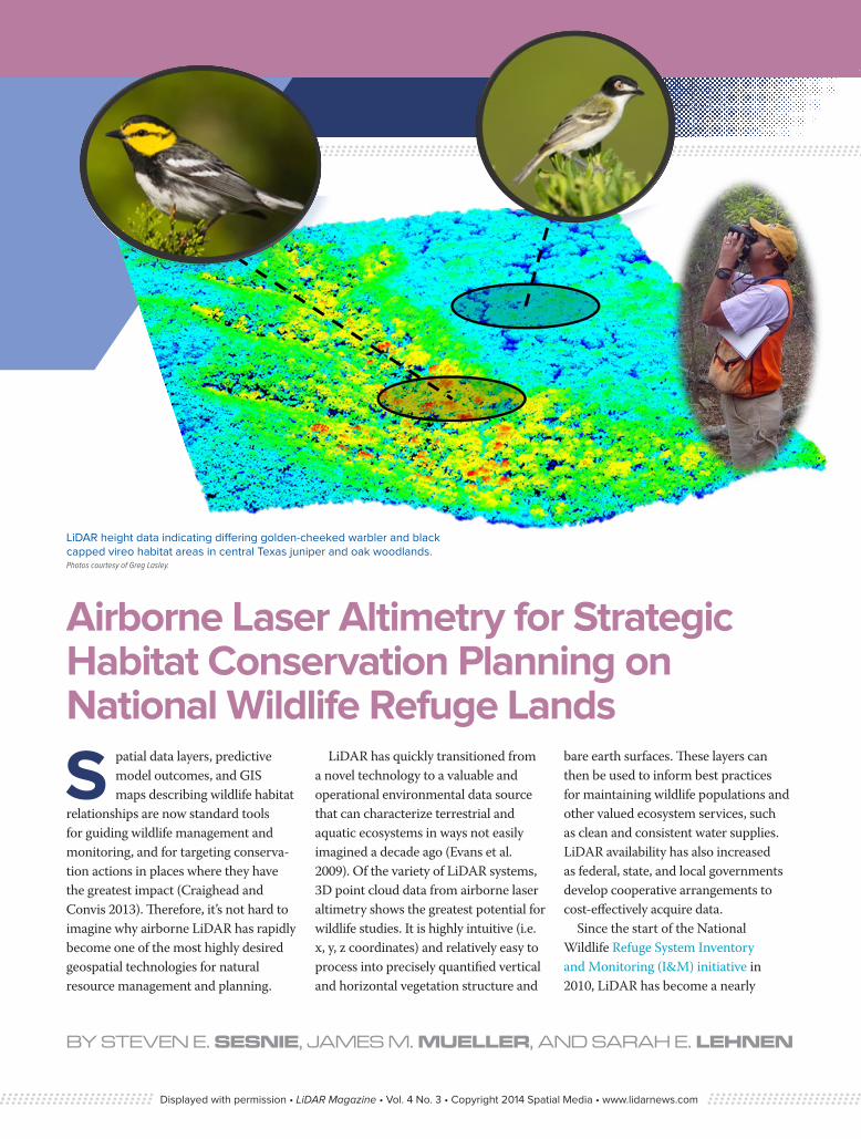
LiDAR height data indicating differing golden-cheeked warbler and black capped vireo habitat areas in central Texas juniper and oak woodlands. Photos courtesy of Greg Lasley.
Displayed with permission • LiDAR Magazine • Vol. 4 No. 3 • Copyright 2014 Spatial Media • www.lidarnews.com
indispensable tool for strategic habitat conservation planning. The Southwest Region of the U.S. Fish and Wildlife Service (USFWS), which encompasses Texas, Oklahoma, New Mexico, and Arizona, is developing and applying LiDAR products in a number of ways to better target habitat conservation, its primary mission. For species reaching critically low population numbers, LiDAR provides a new tool that can be used to reduce species declines and monitor progress toward achieving habitat and population goals.
What does LiDAR offer that is so uniquely suited to answering key questions about how best to sustain healthy wildlife populations? LiDAR has proven effective for developing detailed map layers characterizing habitat, often at spatial scales more closely linked to site conditions selected for reproduction, foraging, and refuge from predators than have traditionally been
available (Vierling et al. 2008). LiDAR 3D point clouds provide detailed height measurements of objects on the ground that can be converted to data layers describing vegetation structure (height, density, and cover), terrain (elevation, solar radiation, and slope conditions), hydrology (site moisture potential, flow paths, and catchment areas), human infrastructure (buildings, transmission lines and towers, wind turbines, and other structures), and fragmentation effects (patch distribution, edge density and distance from woodland edge) across large landscapes. LiDAR, in combination with other airborne and satellite sensors, can also help char-acterize vegetation composition (e.g., broadleaf vs. evergreen trees), leveraging multispectral information in addition to LiDAR height and density metrics.
The above features generated from LiDAR provide a picture of habitat that is readily integrated into a GIS, or
processed using sophisticated statistical models to estimate likelihood of occur-rence, populations numbers or habitat suitability for a species at a level of detail useful to managers.
A recent and compelling example of where LiDAR is now playing a central role in conservation planning is on the 25,000 acre Balcones Canyonlands National Wildlife Refuge (BCNWR) located north of Austin, Texas. The refuge was established in 1992 primarily for the protection of two endangered songbirds, the golden-cheeked warbler (Setophaga chrysoparia) and black-capped vireo (Vireo atricapilla). The entire breeding range of the warbler lies in central Texas, often close to areas undergoing urbaniza-tion at the expense of habitat quality. The vireo breeds throughout a larger area reaching northern Mexico and into parts of southern Oklahoma.
On the refuge, the two species often occur in adjacent habitat at different
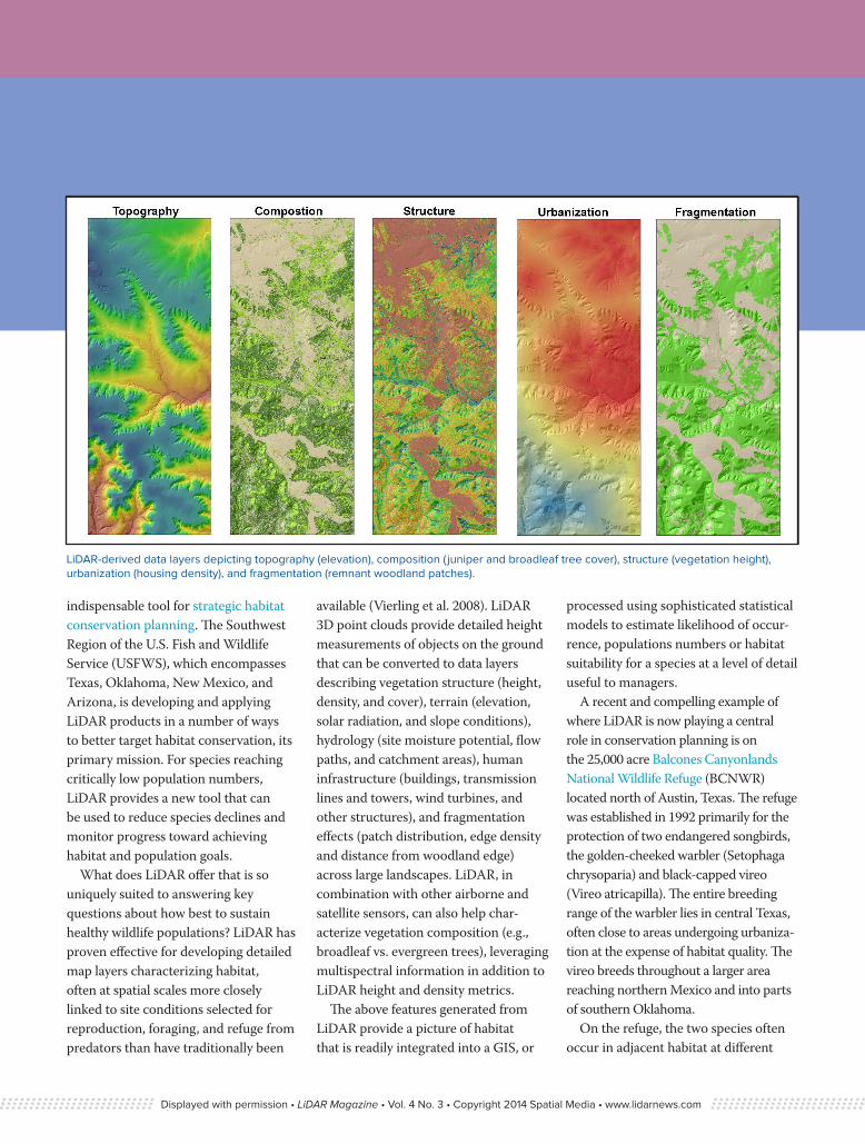
LiDAR-derived data layers depicting topography (elevation), composition ( juniper and broadleaf tree cover), structure (vegetation height), urbanization (housing density), and fragmentation (remnant woodland patches).
Displayed with permission • LiDAR Magazine • Vol. 4 No. 3 • Copyright 2014 Spatial Media • www.lidarnews.com

stages of vegetation succession. Appropriate vegetation structure for the vireo typically develops about five years after a major disturbance such as fire. In contrast, the warbler prefers mature woodlands of oak (Quercus spp.) and Ashe juniper (Juniperous ashsei), requiring 50 to 60 years to develop. A site may be suitable as habitat for either species, but only optimal for one at a given successional stage.
To date, the majority of our work with LiDAR data at BCNWR has focused on modeling habitat relation-ships for the golden-cheeked warbler. BCNWR is currently considered to be about half the size of the area needed to sustain a viable population of warblers, and is complemented by other nearby conservation areas such as the 30,400-acre Balcones Canyonlands Preserve
managed by the city of Austin, Travis County and partners. Understanding the habitat needs of this species ensures that future acquisitions for the federal refuge are the highest quality habitat available for warblers. Better estimates of warbler numbers are also needed to help guide recovery programs managed by the USFWS and a variety of partners.
Developing accurate data layers in a GIS is a primary step for developing credible models of wildlife habitat relationships. An important aspect of distinguishing warbler habitat is determining the amount of juniper and broadleaf tree cover within a breeding territory. A diversity of tree species provides the high quality foraging habi-tat for the insectivorous warbler as it follows arthropod irruptions that occur on different tree species throughout the
spring and summer. Older juniper trees are also necessary for the peeling bark that is used as nesting material.
LiDAR vegetation height fused with high resolution (1m pixels) 4-band color infrared aerial photography from the USDA Farm Service Agency National Agricultural Imagery Program (NAIP) greatly improves opportunities for effectively distin-guishing these habitat differences by reducing misclassification errors that occur when mapping vegetation using supervised image classification techniques. These types of errors can “scale-up”, impacting subsequent data layers and spatial model results important for decision making.
Classified LiDAR points can also greatly help to discriminate important features such as urban and suburban
Golden-cheeked warbler and black-capped vireo study area at Balcones Canyonlands National Wildlife Refuge.
Displayed with permission • LiDAR Magazine • Vol. 4 No. 3 • Copyright 2014 Spatial Media • www.lidarnews.com
infrastructure that can be detrimental to songbirds through increased preda-tion and disturbance. For example, building classified points can be used as model inputs by creating data layers quantifying housing density, distances from urban areas, and other features characterizing human infrastructure and development.
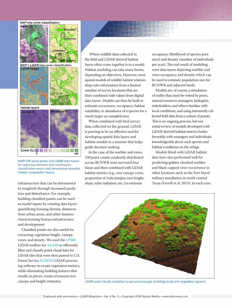
Classified points are also useful for extracting vegetation height, canopy cover, and density. We used the LP360 LiDAR toolbox for ArcGIS to efficiently filter and classify point cloud data for LiDAR tiles that were then passed to U.S. Forest Service FUSION LiDAR process-ing software to create vegetation metrics, while eliminating building features that would, in places, create erroneous tree canopy and height estimates.
Where wildlife data collected in the field and LiDAR-derived habitat layers often come together is in a model. Habitat modeling can take many forms, depending on objectives. However, most spatial models of wildlife habitat relation-ships take information from a limited number of survey locations that are then combined with values from digital data layers. Models can then be built to estimate occurrence, occupancy, habitat suitability, or abundance of a species for a much larger un-sampled area.
When combined with bird survey data collected on the ground, LiDAR is proving to be an effective tool for developing spatial data layers and habitat models in a manner that helps guide decision making.
In the case of the warbler and vireo, 250 point counts randomly distributed across BCNWR were surveyed four times and then combined with LiDAR habitat metrics (e.g., tree canopy cover, proportion of Ashe juniper, tree height, slope, solar radiation, etc.) to estimate
occupancy (likelihood of species pres-ence) and density (number of individuals per acre). The end result of modeling were data layers depicting warbler and vireo occupancy and density which can be used to estimate population size for BCNWR and adjacent lands.
Models are, of course, a simulation of reality that must be vetted by peers, natural resources managers, biologists, stakeholders, and others familiar with local conditions, and using intensively col-lected field data from a subset of points. This is an ongoing process, but our initial review of models developed with LiDAR-derived habitat metrics bodes favorably with managers and individuals knowledgeable about each species and habitat conditions on the refuge.
Models fitted with LiDAR habitat data have also performed well for predicting golden-cheeked warbler and black-capped vireo occurrence in other locations such as the Fort Hood military installation in north central Texas (Farrell et al. 2013). In each case,
LiDAR point clouds classified as ground (orange), buildings (red) and vegetation (green).
NAIP-CIR aerial photo and LiDAR data fusion for reducing omission and commission classification errors and developing essential habitat composition layers.
Displayed with permission • LiDAR Magazine • Vol. 4 No. 3 • Copyright 2014 Spatial Media • www.lidarnews.com
LiDAR-based model outputs provide a foundation for making better informed decisions with respect to identifying, managing, and monitoring habitat areas critical for sustaining viable populations of endangered songbirds. These principal aspects of strategic habitat conservation will continue to drive demand for modern geospatial technologies such as LiDAR.
Currently, we are using LiDAR to address other priority conservation questions, such as the impact of climate change and sea-level rise on critical wetland habitat along Texas Gulf Coast. LiDAR data is presently available for coastal areas of Texas that harbor multiple species such as the critically endangered whooping crane (Grus americana), piping plover (Charadrius melodus), and ocelot (Leopardus pardalis). High precision LiDAR elevation data is vital to predicting where and how sea-level rise may alter coastal wetlands on National Wildlife Refuge lands in Texas and other Gulf Coast States over the next century.
For other parts of the Southwest region, LiDAR is now being acquired to meet many other needs particularly on refuge lands where water resources are managed for waterfowl and marsh-bird habitat. This has benefitted from the partnerships of state and county govern-ments that have cooperated to fund LiDAR data acquisition, resulting in these data being made available to the public at little or no cost. The Texas Natural Resource Information System (TNRIS), Capital Area Council of Governments (CAPCOG) and Lower Colorado River Authority (LCRA) are shining examples of cooperative efforts to acquire and serve LiDAR data for natural resource applica-tions. These types of efforts substantiate the value of LiDAR for natural resource
management. With little doubt LiDAR applications will continue to grow within the USFWS as a highly effective tool for mapping monitoring vegetation and landscape changes at a level of precision that can readily be used for conservation decision making.
ReferencesCraighead, F.L. and C.L. Convis Jr. 2013 Conservation planning from the bottom up: a practical guide to tools and techniques for the twenty-first century. Esri Press, Redlands, CA. 426 p.
Evans, J.S., A.T. Hudak, R. Faux, and A.M.S. Smith. 2009. Discrete return Lidar in natural resources: recommendations for project planning, data processing and deliverables. Remote Sensing 1: 776-794.
Farrell, S. L., B. A. Collier, K. L. Skow, A. M. Long, A. J. Campomizzi, M. L. Morrison, K. B. Hays, and R. N.Wilkins. 2013. Using LiDAR-derived vegetation metrics for high-resolution, species distribution models for conservation planning. Ecosphere 4(3):42.
Vierling, K. T., L. A., Vierling, W. Gould, S. Martinuzzi, and R. Clawges. 2008. Lidar: Shedding new light on habitat characteriza-tion and modeling. Frontiers in Ecology and the Environment. 6: 90-98.
Steven Sesnie is a spatial ecologist at the US-FWS Southwest Region Office in Albuquerque, NM. James Mueller is a zone wildlife biologist at the Balcones Canyonlands National Wildlife Refuge in Marble Falls, TX. Sarah Lehnen is a wildlife biologist and statistician at the USFWS Southwest Region Office in Albuquerque, NM.
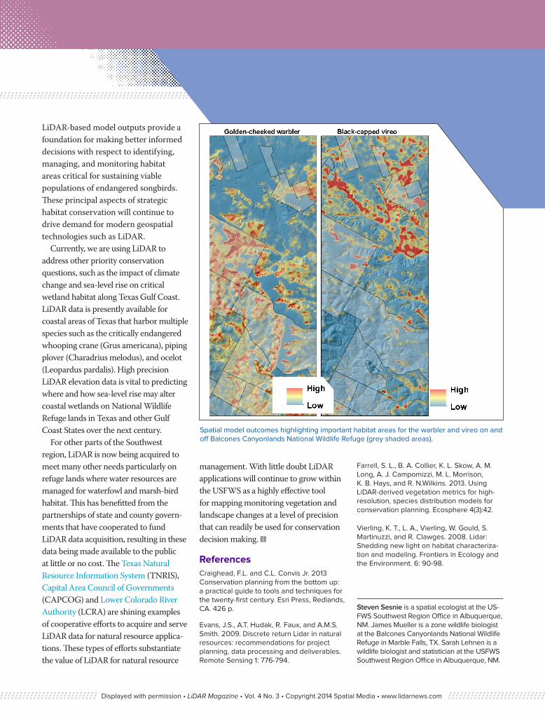
Spatial model outcomes highlighting important habitat areas for the warbler and vireo on and off Balcones Canyonlands National Wildlife Refuge (grey shaded areas).
Displayed with permission • LiDAR Magazine • Vol. 4 No. 3 • Copyright 2014 Spatial Media • www.lidarnews.com