aima newsletter – june 2012 – vol. 31 no. 2 · a condition of the aima scholarship is that the...
TRANSCRIPT

AIMA NEWSLETTER
1
www.aima.iinet.net.au
Australasian Institute for Maritime Archaeology
ABN 37 830 874 307 • Registration No. A0820044J Western Australia Associations Incorporations Act 1987 Section 18(6) • ISSN 1446–8948Australasian Institute of Maritime Archaeology Inc. • Department of Maritime Archaeology • WA Museum • 47 Cliff St • Fremantle WA 6160
Volume 31 | Issue 2 June 2012
I first read about SS Taupo in an old wreck diving book that I picked up in a second-hand bookshop, which
showed an interesting old sidescan image of the site and raved about the underwater conditions there. However, after numerous local enquiries, I could find no one whose dive site itinerary included this ‘great’ dive spot. One day, finally, I received a telephone call out
of the blue from a local diver who said that he had dived the wreck and that he would be happy to take me there the very next day. I accepted eagerly, and the rest—as they say—is history. We dived the site and were fortunate to have over 20m of visibility; the experience left me inspired.
I began researching the history of SS Taupo and quickly found a connection to my own roots. The ship was built in 1874 by William Denny and Brothers Ltd of Dumbarton, Scotland, on the River Leven, during the famous era of Clyde shipbuilding on Scotland’s west coast. At the time, Dunedin shipping entrepreneur James Mills was looking to expand coastal shipping in NZ and travelled to meet Peter Denny, founder of the shipbuilding company. The two men struck a deal to build two steam-powered vessels for Mill’s grand plan.
The SS Taupo ProjectBay of Plenty, New Zealand
Considering its population and age (of European involvement), the island-nation of New Zealand has a large number of shipwrecks. The Bay of Plenty, towards the top of the North Island, has its fair share of wreck sites, including that of SS Taupo, which lies about seven miles off the coast of Tauranga and has a particularly interesting history.
IssueIN THIS
by Shane Wasik
(continued on p. 9)
A diver conducts a video survey of the SS Taupo shipwreck site. (Photo by Shane Wasik)
1 The SS Taupo Project — Bay of Plenty, New Zealand
2 AIMA Officers’ Reports UNESCO Scientific and Technical Advisory Board, Support for UCH, AIMA Scholarship 2012
3 Australasian News from NSW, NZ, QLD, SA, VIC and WA
25 AIMA Scholarship 2011 Project Report J5 Submarine Preservation Project, Getunder Dive Club
34 World News Kingdom of Tonga35 Conference News ODEX 2012,
AIMA/ASHA Conference 2012 36 Artefacts Spotlight Mystery
objects from Cape Town (South Africa) Waterfront
AIMA2 NEWSLETTER
AIMA Newsletter | June 2012 | Volume 31 | Issue 2 ISSN 1446–8948
NEWSLETTER3AIMA
AIMA Newsletter | June 2012 | Volume 31 | Issue 2ISSN 1446–8948
UNESCO Paris meeting of the Scientific and Technical Advisory Board
As AIMA representative, I attended the 2012 UNESCO meeting of the Scientific and Technical Advisory Board (STAB) in April. AIMA joined other significant NGOs, such as NAS, SHA, ACUA, ICUCH and JNACP. NGOs were included in the meeting to provide additional advice and support to the STAB. As issues arose, NGO representatives had opportunities to comment, provide expert knowledge and offer advice on specific regional initiatives or concerns.
Several discussions and resolutions were relevant to the business of AIMA. Resolution 3, “Cooperation with and Consultation of NGOs”, was particularly pertinent (see full set of resolutions and recommendations attached to this Newsletter). Resolution 3 clearly
2012June
From the President’s deskUNESCO Scientific and Technical Advisory Board,
support for UCH, and more . . .
outlines the role STAB feels NGOs can play in supporting them and the 2001 Convention. This appeared to be an important resolution because going into the meetings there was a question, or concern, about how NGOs would actually function. As the meeting progressed, it seemed that NGOs were a valuable addition in that they had “free range” with regards to their comments on critical or sensitive issues, as opposed to STAB, who at times may not have been able to comment or provide advice under the direction of their State Party. As a representative of AIMA, I provided advice on regional initiatives and issues where appropriate. AIMA was represented as being active in several key areas including education, public outreach and national inventories.
Overall I felt like AIMA’s participation in the meeting communicated our continuous support for the 2001 Convention and our colleagues’ efforts in protecting UCH. Additionally, acknowledgement as an accredited UNESCO NGO further strengthens our
struggle on the home front in ratifying the 2001 Convention. If members have suggestions or ideas related to the resolutions and recommendations for how AIMA can contribute, please feel free to send them through the list or directly to me.
Letters and Support for UCH
I’d like to thank two AIMA members who were active writing letters and preparing submissions in this last quarter. Thanks to Andy Dodd for putting together an excellent submission for the review of the Historic Places Act in New Zealand in June. Also, a job well-done to Adrian Brown, who wrote letters to ABC’s Auction Room and Media Watch concerning Episode 7, in which Tek Sing artefacts were promoted. No response was received from Media Watch, but ABC did respond in a letter circulated to the members via email. The letter was met with disappointment as ABC skirted the issues and still appear to support the sale of artefacts recovered unethically.
— Jennifer McKinnonAIMA President
AIMA is pleased to announce the 2012 AIMA Scholarship for maritime archaeological
research projects. The investigation or project must be consistent with the objectives of AIMA and the work must have a benefit or application to maritime archaeology in Australasia. The award is open to all persons
AIMA Scholarship 2012conducting applicable research within Australasia.
A total of up to $2000 will be awarded, and AIMA may choose to partially fund more than one project from these monies in 2012. A condition of the AIMA Scholarship is that the recipient(s) is required to publish in the AIMA Newsletter or, for larger awards, a peer-reviewed paper either in the AIMA Bulletin or in the AIMA Special Publication series. This
award also comes with a free one-year AIMA membership.
The Application Packet will be available on the AIMA website. Applications must be forwarded to the AIMA Scholarship Chair by 30 June 2012 to be eligible for this award.
For direct access to applications and other queries, contact AIMA Scholarship Chair Emily Jateff at [email protected].
New South Wales
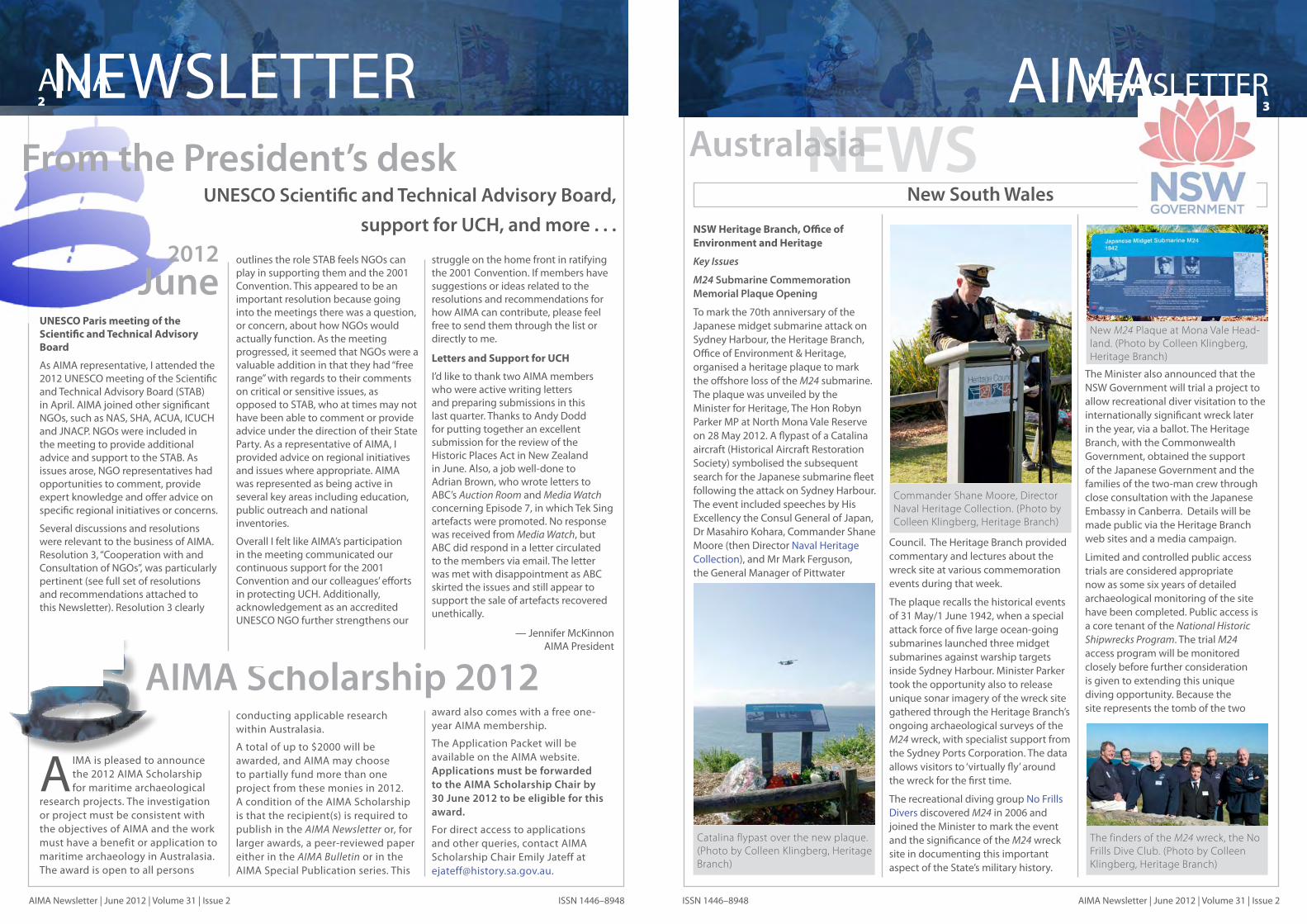
NSW Heritage Branch, Office of Environment and Heritage
Key Issues
M24 Submarine Commemoration Memorial Plaque Opening
To mark the 70th anniversary of the Japanese midget submarine attack on Sydney Harbour, the Heritage Branch, Office of Environment & Heritage, organised a heritage plaque to mark the offshore loss of the M24 submarine. The plaque was unveiled by the Minister for Heritage, The Hon Robyn Parker MP at North Mona Vale Reserve on 28 May 2012. A flypast of a Catalina aircraft (Historical Aircraft Restoration Society) symbolised the subsequent search for the Japanese submarine fleet following the attack on Sydney Harbour. The event included speeches by His Excellency the Consul General of Japan, Dr Masahiro Kohara, Commander Shane Moore (then Director Naval Heritage Collection), and Mr Mark Ferguson, the General Manager of Pittwater
Council. The Heritage Branch provided commentary and lectures about the wreck site at various commemoration events during that week.
The plaque recalls the historical events of 31 May/1 June 1942, when a special attack force of five large ocean-going submarines launched three midget submarines against warship targets inside Sydney Harbour. Minister Parker took the opportunity also to release unique sonar imagery of the wreck site gathered through the Heritage Branch’s ongoing archaeological surveys of the M24 wreck, with specialist support from the Sydney Ports Corporation. The data allows visitors to ‘virtually fly’ around the wreck for the first time.
The recreational diving group No Frills Divers discovered M24 in 2006 and joined the Minister to mark the event and the significance of the M24 wreck site in documenting this important aspect of the State’s military history.
The Minister also announced that the NSW Government will trial a project to allow recreational diver visitation to the internationally significant wreck later in the year, via a ballot. The Heritage Branch, with the Commonwealth Government, obtained the support of the Japanese Government and the families of the two-man crew through close consultation with the Japanese Embassy in Canberra. Details will be made public via the Heritage Branch web sites and a media campaign.
Limited and controlled public access trials are considered appropriate now as some six years of detailed archaeological monitoring of the site have been completed. Public access is a core tenant of the National Historic Shipwrecks Program. The trial M24 access program will be monitored closely before further consideration is given to extending this unique diving opportunity. Because the site represents the tomb of the two
Commander Shane Moore, Director Naval Heritage Collection. (Photo by Colleen Klingberg, Heritage Branch)
NEWSAustralasia
The finders of the M24 wreck, the No Frills Dive Club. (Photo by Colleen Klingberg, Heritage Branch)
Catalina flypast over the new plaque. (Photo by Colleen Klingberg, Heritage Branch)
New M24 Plaque at Mona Vale Head-land. (Photo by Colleen Klingberg, Heritage Branch)

AIMA4 NEWSLETTER
AIMA Newsletter | June 2012 | Volume 31 | Issue 2 ISSN 1446–8948
NEWSLETTER5AIMA
AIMA Newsletter | June 2012 | Volume 31 | Issue 2ISSN 1446–8948
Japanese submariners who went down with their craft in 1942, there will be strict conditions on all divers accessing the site.
For further information about the Japanese midget submarine attack on Sydney Harbour, please see: http://m24maritime.heritage.nsw.gov.au/
Australian Historic Shipwreck Preservation Project
Brad Duncan participated in this project in Port Phillip Bay, Victoria, which is testing the viability of reburying shipwreck artefacts excavated from Clarence back onsite (after recording) as an alternative method to long-term conservation of relics. He spent 3 weeks at the project in April and May 2012.
(See project article on pages 21–24.)
Australian Pioneer Village Dugout Canoe Wreck
In March 2012, the Branch became aware of the remains of a dugout canoe that had been recovered from the Hawkesbury River, near Wilberforce, in the 1980s. Brad Duncan undertook an inspection of the canoe, which is now housed in the school house at the Australian Pioneer Village. The deteriorated condition of the canoe, which has not been treated since
its recovery, retarded the ability to determine its origins as either an Aboriginal or Non- indigenous watercraft. A former cross-river punt was also photographically recorded.
Windsor Bridge Inspection
Tim Smith and Brad Duncan inspected the location of the proposed new bridge at Windsor in May 2012. The proposed bridge location is located at the site of the former Windsor Government Wharf and historic Thompsons Square, the former town common, which dates back to Governor Macquarie’s time. The Heritage Branch has provided input into the Heritage Assessment of the site prepared by
Cosmos Archaeology for the Roads and Maritime Services.
Barangaroo Visit
Heritage Branch Staff attended a special inspection of the Barangaroo South development site at Darling Harbour in June 2012, conducted by Casey and Lowe Heritage Consultants. The archaeological program was undertaken under Part 3A approval and has revealed numerous periods of maritime infrastructure sites, including jetties, sea walls and warehouses which had been buried under subsequent landfill, some dating back to the early nineteenth and late eighteenth century. Brad Duncan revisited the site to assist the excavators in the identification and interpretation of site specific structures. The excavation is providing valuable insights into nineteenth century reclamation and maritime waterfront practices of early Sydney, and is providing a benchmark for the consideration of buried maritime heritage sites in landfill. The Heritage Branch would like to thank Lend Lease, the site developer and their heritage consultants, Mary Casey and Abi Cryerhall of Casey and Lowe Pty Ltd., for taking organising the tour of the site (see article by Abi Cryerhall below)
New Wrecks Exposed
Recent storm activity over the last 3 months has uncovered a number of sites along the NSW coast. In some areas up to 85m of beach width have been scoured away, leaving the coast with steep eroded dunes and limited beach access. This has been a boon for the discovery of previously buried maritime heritage sites.
The Branch’s maritime archaeologist
Site of old Windsor Wharf. (Photo by Tim Smith, Heritage Branch)
(Brad Duncan) undertook fieldwork to inspect and document the remains of two shipwrecks which were uncovered in recent storms at Evans Head and Wooloolga (near Coffs Harbour).
Evans Head Unidentified Shipwreck
The first wreck is an unidentified timber vessel located on Airforce Beach approximately 3.5km north of Evans Head. The wreck has been exposed previously and appears to normally be buried under foreshore sand dunes, but now lies in the intertidal zone. The wreck is in two pieces
consisting of the bow and (possible) stern sections, suggesting that the vessel broke in half either when it washed ashore or as a result of wave and/or erosion activity. It is likely that the vessel may be the remains of either the two masted UK built schooner Pilot (lost 1874), or the Australian schooner Jessie Matilda (1889). A timber sample which appears to be of Australian origins, is currently being tested. Further research is being undertaken to determine the wreck’s identity.
Buster 1893 / Woolgoolga Pier
Brad Duncan (Heritage Branch) and Kieran Hosty from the Australian National Maritime Museum travelled to Woolgoolga on the New South Wales mid north coast to examine the remains of the Canadian built 310-ton gross, wooden, three-masted barquentine Buster, which had been exposed when winter storms stripped away several metres of sand from the town’s main beach in June 2012. The inspection was assisted by staff from the Solitary Islands Marine Park led by David Greenhalgh, a Commonwealth Historic Shipwrecks Wreck Inspector, with intern Amanda Johnson.
Although first gazetted as a town in 1888, it was the construction of a 1,557 ft (475 m) long government jetty at Woolgoolga in 1891 that saw several sugar mills and timber mills open in the area. Whilst the sugar industry never really developed, the timber mills, connected by bullock tracks, tramways and light rail to the densely forested Jesse Simpson Ranges, saw Woogoolga mill owners take advantage of the insatiable demand in
Brisbane and Sydney for grey gum, white mahogany, tallowwood, grey box, turpentine and Australian cedar. In only a few short years, millions of feet of railways sleepers, sawn timbers, piles, logs and fence palings were being exported from the port and Woogoolga was rivalling Coffs Harbour as the principle shipping port along this section of coast; it was even considered—for a short time—as being capable of coping with significant overseas trade until better rail and road access saw the port decline in importance in the 1940s (Clarence and Richmond Examiner, 10 June 1909).
Although Green Head, just to the south of the town, gave the Woogoolga jetty some protection, the roadstead was open to storm-driven seas and swells from the east and north, making the loading of timber difficult, if not impossible, at times. During such conditions, waiting vessels could tie up at one of the offshore moorings until they could come alongside the jetty.
Although steam shipping was dominant by this time, a huge fleet of sailing ships—often relatively small and run by small, independent companies or even individual owners—crisscrossed the globe, transporting a variety of bulk and relatively low-value cargoes in competition with the more prestigious and costlier steamers. One of these was the barquentine Buster, launched in Nova Scotia in 1884, but then Australian-owned, which departed Sydney for Woogoolga in mid-February 1893 to load timber for various New Zealand ports. The vessel arrived safely at Woogoolga, but due to the blustery conditions, could not get alongside the jetty, putting down two anchors and running hawsers to one of the offshore moorings to wait it out.
Unfortunately, over the next few hours, conditions deteriorated rapidly and, early on the morning of Friday 17 February, the port anchor cable parted, followed shortly afterwards by the starboard cable. For the next nine hours Buster rode out the waves, moored by its hawsers to the mooring buoy, but
Dugout canoe, Australian Pioneer Village, Wilberforce. (Photo by Brad Duncan, Heritage Branch)
Canoe and Australian Pioneer Heritage Village Society President, Danielle Wheeler. (Photo by Brad Duncan, Heritage Branch)
Stern section of the Unidentified Evans Head Wreck facing forward. Note bow section in distance and eroding sand dune face. (Photo by Brad Duncan, Heritage Branch)
Archival photo of the site. (Photo courtesy of Richmond Valley Council Heritage Study 2007)
Bow section of the Unidentified Evans Head wreck. Note the large breasthook at the tip of the range pole. (Photo by Brad Duncan, NSW Heritage Branch)
Unidentified Car Ferry Punt, Australian Pioneer Heritage Park (Photo: Brad Duncan, Heritage Branch)

AIMA6 NEWSLETTER
AIMA Newsletter | June 2012 | Volume 31 | Issue 2 ISSN 1446–8948
NEWSLETTER7AIMA
AIMA Newsletter | June 2012 | Volume 31 | Issue 2ISSN 1446–8948
shortly after 7:00 PM, a huge sea struck and first the one and then the other hawser parted. In driving rain, Buster was blown through the breakers and crashed onto the beach stern-first, with its bow slewing towards the south. The crew, seeking safety from the breaking seas, climbed into the rigging. Dawn found them wet, cold, shaken but safe, and now high and dry on the beach a
mile or so north of the town.
Although the vessel had not broken up in the surf, it proved impossible to refloat, and after several attempts, was given up as a total loss. After the salvage of whatever could be retrieved—masts, rigging and presumably some of its timbers—the sand slowly covered the hull remains until only a few of its timber frames
and iron riders
poked above the surface of the beach. In severe winter storms over the last 119 years, the sand covering Buster has been scoured away from time to time, revealing an amazing jumble of well-preserved timbers, which has proved to be an attraction for local residents and holiday makers.
Although the wreck of Buster has been periodically exposed, and has been
inspected on several occasions since 2000 by the Heritage Branch, recent storms have uncovered previously buried sections of the wreck. The June 2012 two-day survey of the bow and port side of the wreck revealed previously unknown insights into the construction methods used on the vessel. The wreck is in a remarkable state of preservation, with remains of the keelson, masts steps, rigging and even sheathing planking evident on the outer hull. Detailed recording of the site included a survey of the bow, mast steps and other compartment fittings within the wreck, with a focus on fastening methods and scantlings. The vessel appears to be rather substantially built
of Oregon Pine (Douglas Fir), with 10-inch (252-mm) square futtocks and a substantial 11-inch (280-mm) rider keelson evident along the centreline. It is anticipated that both wrecks will soon be naturally reburied by sand dunes, which is already occurring on the Buster wreck. Reports also have been received in the last week that the remains of the Woolgoolga Pier are also emerging from the sand.
During this latter fieldwork, the locations of the graves of two victims from the Keilawarra and Helen Nicoll collision located on Look-at-me-now Headland were fixed with GPS, and the sites photographed. Keilawarra
Buster hull facing south. (Photo by Brad Duncan, Heritage Branch)
wrecked at Coffs Harbour in 1886 after colliding with Helen Nicoll, which resulted in the loss of some 48 lives.
Public Engagement
M24 Commemoration Events
The end of May heralded the 70th anniversary of the sinking of the M24 midget submarine and the Battle of Sydney. As part of the week-long commemorations, Tim Smith and Brad Duncan participated in a number of events, including the M24 Plaque opening, HMAS Kuttabul Ceremony at Garden Island and the Commemoration Service at the ANZAC Memorial in Hyde Park. Tim also participated in the Kuttabul Commemoration Project heritage cruise organized by Gary Traynor, and presented at another
midget submarine heritage cruise hosted by the Australian National Maritime Museum with researcher Steven Curruthers. Tim also presented a paper on the management of the midget submarine at a seminar hosted by the Historic Houses Trust, with Dr Peter Stanley Head, Centre for Historical Research, National Museum of Australia.
Buster 1893 Plaque support, Woolgoolga
The Heritage Branch has provided financial assistance and expertise with upgrading interpretative signage for the Buster shipwreck and wider Solitary Islands shipwreck heritage. During previous exposures of the wreck in 2010, it became evident that planks were becoming dislodged from the site through natural processes, and were
subsequently collected by local Solitary Islands Marine Parks representatives. Piles form the former Woolgoolga Jetty had also been reported washing up on the beach. The Branch is currently investigating possible uses for these relics, including either for shore-based shipwreck interpretation or for reburial on the beach (where again they would be in danger of washing away).
‘Diving into Archaeology’ Seminar
The Heritage Branch hosted its annual seminar called “Diving into Archaeology” on 23rd May 2012 as part of the nationwide program of activities intended to celebrate National Archaeology Week. National Archaeology Week aims to increase public awareness of Australian archaeology and the work of Australian archaeologists, and promote the importance of protecting Australia’s unique archaeological heritage. More than 80 participants, from a wide range of backgrounds, attended the 2012 seminar. Speakers included Heritage Branch Deputy Director Tim Smith, Brad Duncan, Australian National Maritime Museum Curator Kieran Hosty and independent researcher Joanne Edney.
Lectures to Sydney University Archaeology Courses
Brad Duncan and Tim Smith have delivered a total of eight lectures to an undergraduate course in maritime archaeology at the University of Sydney run by Dr Martin Gibbs. The Heritage Branch is currently strengthening ties with the Archaeology and Geography Departments, and has planned joint fieldwork on several shipbreaker yard sites in Sydney Harbour (including Homebush Bay) and wharf sites in the Parramatta River (Including Lockyer’s Wharf ). The sites will provide training opportunities for students, whilst generating archaeological plans to be used for site management.
Lectures
Brad Duncan presented two lectures on the results of the HMAS Australia heritage assessment and underwater
photographic survey to the Naval Historical Society of Australia (NSW) and to the Engineering Heritage Australia quarterly lecture series in June. Tim Smith presented a lecture on the midget submarine to the Maritime Museums Conference in February at the Australian National Maritime Museum, the Northern Beaches National Services Association in June, and a Connected Classroom session on the midget submarine hosted by the Historic Houses Trust.
Annual Maritime Heritage Poster soon to be released
This year’s Maritime Heritage Poster has focussed on recent fieldwork at the Wingecarribee River to investigate the submerged remains of canoes built by German World War I internees at Berrima (see the March 2012 AIMA Newsletter, Vol. 1, Issue 1, p. 5). These often elaborately decorated canoes were built for pageants on the river and for recreational activities, and were scuttled after the cessation of hostilities in 1919. The discovery of one canoe hull in a sandbank downstream of the site in the 1970s prompted fieldwork by the Heritage Branch to relocate other canoe remains in the river. The poster highlights the historical and archaeological significance of this inland heritage site, which has been listed on the NSW State Heritage Register. The poster, which is partially subsidised by the Federal Department of Sustainability, Environment, Water, Population and Communities, is in the final stages of production, with a probable release date of August 2012.
Norah Head Heritage Workshop
Following the discovery of several Aboriginal and non-indigenous sites at Norah Head in 2011, the Central Coast Council is hosting a Heritage Workshop in August on heritage sites in the area. Brad Duncan will be presenting a paper of NSW maritime heritage.
Other Matters
HMAS Sydney Mast Working Group
Tim Smith represents the Heritage
HMAS Kuttabul Memorial.
Buster starboard hull section. (Photo by Brad Duncan, Heritage Branch)
Details of Buster anchor locker. (Photo by Brad Duncan, Heritage Branch)
Kieran Hosty and Brad Duncan recording anchor the Buster locker. (Photo by Amanda Johnson, Department of Primary Industries, Coffs Harbour)
Kieran Hosty and Brad Duncan recording anchor the Buster locker. (Photo by Amanda Johnson, Department of Primary Industries, Coffs Harbour)
Amanda Johnson inspects one of the Keilawarra Graves; (insert) detail of the grave marker of an unknown male victim. (Photos by Brad Duncan, Heritage Branch)

AIMA8 NEWSLETTER
AIMA Newsletter | June 2012 | Volume 31 | Issue 2 ISSN 1446–8948
NEWSLETTER9AIMA
AIMA Newsletter | June 2012 | Volume 31 | Issue 2ISSN 1446–8948
Branch on the OEH-led Bradley’s Head Mast Precinct Working Group. The Group has been formed to discuss the scope of works, conservation program and landscape activities at the State Heritage Register-listed mast which is subject to a major refurbishment ahead of the Royal Australian Navy’s centenary celebrations of the arrival of its first Fleet (2013). Brad Duncan attended several related meetings early this year on Tim’s behalf.
Maritime Heritage Online web site transfer
Brad Duncan has been working with OEH web staff and consultants as part of the upgrading of the Maritime Heritage Online Website to a new platform in June/ July 2012. As part of this process, OEH is providing selected staff members with training
in the “Team site” program as web editors. The new platform has several new features that will allow users to view site locations using Google Maps and Google Earth; make direct data dumps for sister agencies and other stakeholders; and undertake maintenance of the web site directly by Branch staff.
New Maritime Archaeological Survey Equipment
The Branch has purchased new equipment to be used for site inspections. The new equipment includes a Hummingbird Side Imaging® unit (for underwater remote sensing), a Leica Sprinter auto level (for land surveys), a digital camera and under-water housing, an underwater metal detector, GPS, and laser rangefinder.
New Maritime Archaeological Advisory Panel appointments
The tenure of the current Chair of the Panel, Debbie Hardy, has expired. The Heritage Council of New South Wales supported the nomination of the following Members to the positions as specified below for the standard 3-year terms (4 April 2012 – 3 April 2015):
Dr Wayne Johnson as Chair of the •Maritime Archaeology Advisory Panel;
Commander Damien Allan (RAN) as •Deputy Chair (second term);
Karina Acton as representative for •materials conservation (second term);
Dr Cindy McCreery as Maritime •Historian representative.
—Brad Duncan and Kieran Hosty
Around the same time, Francis Girard, another early grant holder, also had reclaimed a large parcel of land to the south of the site. Girard built and operated a flourmill adjacent to the foreshore and the reclaimed land supported the maritime infrastructure necessary for his milling business. Land consolidation and modifications to the wharf and jetties were ongoing up to the 1860s, by which time the Australasian Steam Navigation Co. occupied the site. Archaeological remains include a relatively intact timber wharf, sandstone walling that functioned both as a warehouse footing and a seawall, and occupation-related deposits for both the warehouse and a store. Within the warehouse was an extensive in situ deposit of charred hessian sacks, grains and corn, indicating that there was a fire in the later 19th century. Only minor fire damage to the timber wharf was evident.
The large parcel of land between Girard’s and Bass’ parcels was the last to be developed. By the 1840s, it was owned by Breillat. According to early historical plans and the archaeological evidence, reclama-tion of this foreshore appears initially to have been rather piecemeal. However, during the 1840s and 1850s, the land was consolidated and retained by a substantial sand-stone seawall that was at least 45m in length and 2–3m in height. The base of the seawall was about 1m below the low tide mark and built on rubble fill overlying the harbour floor. At the southern end of the wall was a timber jetty and to the east, on the land side, were the remains of two structures: a smithy’s workshop and a store building. By the 1870s, the land had been consolidated and a further three courses added to the seawall. An
occupation deposit within the store building yielded artefacts associated with the men who worked on this wharf.
The eastern foreshore of Darling Harbour was vitally important to the 19th-century industrial and economic development of Sydney. The excavation of such a large portion of this maritime landscape has provided a phenomenal amount of archaeological evidence relating 19th-century reclamation and development of maritime infrastructure.
—Abi CryerhallCasey & Lowe Pty Ltd
Barangaroo South, a Casey & Lowe Pty Ltd Project
The redevelopment of Barangaroo South by Lend Lease (Millers Point) has provided an opportunity to undertake a detailed archaeological investigation of this significant former 19th-century wharf site. Development of this part of Darling Harbour’s eastern foreshore was begun by the 1830s with the construction of jetties and wharves, infrastructure necessary for the shipping of goods and raw materials to and from the businesses located on the waterfront. Extensive and substantial archaeological remains of sandstone
seawalls, reclamation fills, jetties, wharves, yard surfaces and warehouses provide evidence of how this site was formed, remodelled and utilised throughout the 19th century. The Casey & Lowe team have just concluded a 10-month excavation program, completed in three stages between January 2011 and August 2012.
Located at the northern end of the site, Henry Bass’ land grant was one of the earliest holdings. By the 1830s, he had reclaimed a portion of land to provide wharfage for his shipbuilding business. A roughly built sandstone seawall
keyed-in to the natural sandstone shoreline retained the southern edge of the reclamation. A building depicted on plans from the 1850s was built mostly on an elevated natural outcropping, but with its western façade and verandah on the seawall and the newly reclaimed land surface. This demonstrated how its construction respected both the natural topography and the man-made landform. It was demolished in the late 1800s, and though annotated as an ‘office’ or ‘store’ on historic plans, the artefacts suggest that at one time it also was a domestic dwelling.
1875 plan showing the original shoreline near modern Hickson Road. The study area is full of mid 19th-century jetties and warehouses. (SRNSW, AO Map 4775)
Visitors from the Heritage Branch inspect the 1840s sandstone seawall with timber pile revetment and later modifications. (Photo by Brad Duncan, NSW State Maritime Archaeologist)
Sandstone seawall constructed around the 1840s, probably by Breillat, with three courses in larger stones added after the initial construction. (Photo by Phil Noller, The Moment It Clicks Pty Ltd, on behalf of Lend Lease)
The Archaeology of Darling Harbour’s Eastern Foreshore
Archaeologist Mike Hincks records the Australasian Steam Navigation Co. timber wharf remains at high tide. (Photo by Abi Cryerhall)
New Zealand
In 1875, the sisters Taupo and Hawea were drafted into service as the flagships for the new Union Steamship Company of New Zealand, which would become one of the most successful shipping lines in the South Pacific. Four years later, in fine weather, Taupo ran aground at Mount Maunganui. It took two years to patch the ship using some experimental techniques, but it started taking on water while being towed back to Auckland, the ship’s pumps were overwhelmed and the vessel foundered in 34m of water.
Tragedy struck again in the 1980s when the shipwreck was discovered by fishermen and divers began visiting the site. Some of the latter attempted to salvage non-ferrous metal and
other artefacts using explosives, which angered local residents. Since the wreck was 100 years old, it was under statutory protection and the divers were prosecuted under the Historic Places Act.
I moved from Scotland to the Bay of Plenty in 2009. Having a passion for shipwrecks, I made a personal connection to SS Taupo. I have a background in marine science and had completed a NAS course in Scotland in 1999. Following that first dive on the Taupo site, I hatched a plan to map the wreck site and document the sea life that inhabited it, as well as other biological parameters.
The Historic Places Trust were receptive to my plan and supported my funding application to the Bay of Plenty Regional Council. After successfully
obtaining council funding, I assembled a project team from the Mount Maunagnui Underwater Club, the University of Waikato, and the Bay of Plenty Polytechnic Univer-sity.
Maritime archaeologist for New Zealand’s Department of Conservation (and AIMA State Councillor) Andy Dodd ran an AIMA/NAS course for the
(continued from p. 1)
SS Taupo at Port Chalmers. (Photo courtesy of DeMaus, Hocken Collections, Uare Taoka o Hākena, University of Otago)

AIMA10NEWSLETTER
AIMA Newsletter | June 2012 | Volume 31 | Issue 2 ISSN 1446–8948
NEWSLETTER11AIMA
AIMA Newsletter | June 2012 | Volume 31 | Issue 2ISSN 1446–8948
of the northern harbour entrance, the run-off from which can affect water visibility. The final challenge, to which I previously alluded, is the 34m site depth, which means that diving with traditional single-cylinder open circuit SCUBA, even when using a 32% Nitrox mix, is limited to a bottom time of around 20 minutes. The number of measurements that can be taken by a single buddy pair on one dive is hindered by these constraints. We were fortunate to have a number of technical divers (myself included) using twinsets and rebreathers to bolster our ranks. These divers could stay on the bottom for 30–50 minutes per dive and accomplish much more work, or take on more time-consuming tasks.
Our solution to the bottom time issue was to put more divers in the water, so as to achieve the same cumulative time on site. On our first day on site, we deployed eight buddy pairs making two dives separated by a mandatory minimum 3-hour surface interval. Repeating this over a number of days, we eventually completed all the work.
For the wreck survey, we ran baselines along the seabed between three points—located at bow, midships and
stern—that were marked by weighted lines running from the site to buoys on the surface. The lines were kept as taught as possible so that accurate GPS readings could be taken from the surface. These three lines also aided divers in navigating underwater (as narcosis could be a factor) and helped prevent them from swimming the wrong way in confusion and wasting precious bottom time.
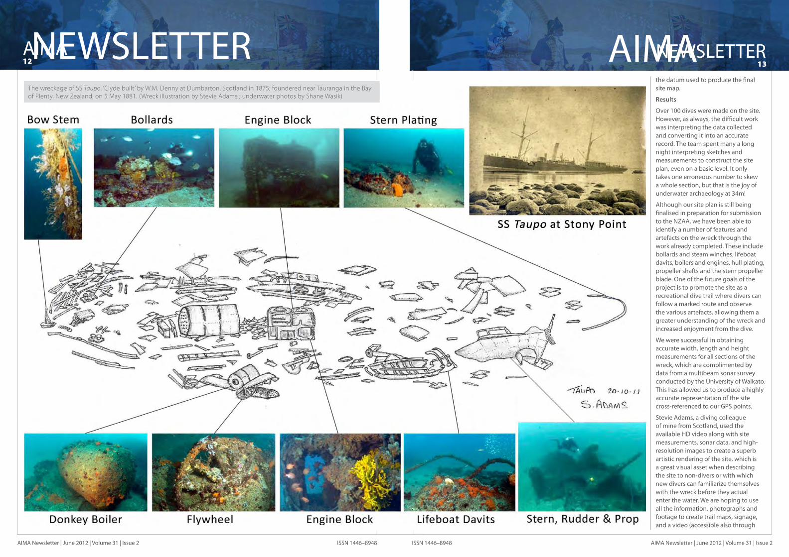
Eventually, the team set four baselines (two on each side of the wreck) and recorded the entire length of the wreck with 90-degree offset measurements at 3m intervals, or where there was a particular feature of interest. As the shipwreck is approximately 100m long, this was a formidable task. Also, since the wreck has a vertical height of up to 4m from the seabed, we needed a method that accounted for this three-dimensional nature of the site.
We calibrated our depth gauges and recorded the depth of each point we measured, along with its associated pair of offset and baseline distances, so that we could accurately correct the measurements. The team laid a final baseline along the centre of the wreck and plotted the eight marker pegs (endpoints) of the other four baselines relative to it. This centreline serves as
Survey diver geared up and ready to go. (Photo by Shane Wasik)
Photomosaic of the bow section of the SS Taupo wreckage. (Photomosaic by Shane Wasik)
SS Taupo on Stoney Point.
project’s divers that included
Our World–Underwater Scholarship Society’s® 2011 Australasian Rolex Scholar Anthea Ibell. This course ensured that our divers had a good grounding in underwater survey techniques and understanding of proper procedures for working on an underwater archaeological site. Some of the team who were not already qualified also went on to complete their Nitrox (Enriched Air Nitrox, EANx) training and certification. As the wreck lies in 34m of water, any extra bottom time was precious (Nitrox breathing gases reduce nitrogen uptake in a diver’s body and so extend the possible dive time and/or reduce the decompression/off-gassing time required to avoid decompression sickness).
May 2011 included
the 130th anniversary of Taupo’s sinking, and I had planned all the survey work to coincide with the event. Unfortunately, Mother Nature in Autumn had other plans! It took the better part of our Kiwi winter to finally accumulate enough time on site to complete all of the measurements. Let me assure you, organising an underwater project and coordinating up to 20 volunteer divers in the midst of erratic weather is no easy feat!
Location of SS Taupo wreck site.
Interpreting the data aboard Mantra. (Photo by Shane Wasik)
Divers taking offset measurements near the stern of SS Taupo. (Photo by Shane Wasik)
Sketch of the wreck site baseling.
Objectives
The objectives of the project were 1) to produce an initial map of the shipwreck that highlighted prominent features and 2) to conduct a biological survey of the site, accomplishing both with the limited time, resources and money that we had at our disposal. The shipwreck survey, as described below, would then be used to update the NZAA archaeological records and to generate interest in the site from divers and non-divers alike.
The biological survey included fish counts in several transects of the wreck that we defined using the survey baselines (discussed below). We identified a variety of fish and invertebrate species inhabiting the wreck structures, and made a count of the crayfish populations. Not only does this information give us a view of how sea life interacts with shipwrecks (basically man-made reefs), but also it allows us to establish baseline data with which to monitor the site going forward. Since one of our goals is to promote the wreck to the diving community, this will be important to make sure that such increased human activity does not negatively impact marine life at the site.
Methodology
The main challenge of this site is its position and depth. The wreck lies in open water, meaning it is exposed to the weather, and there are only particular weather patterns in which diving conditions are favourable. The wreck also lies directly offshore
AIMA12NEWSLETTER
AIMA Newsletter | June 2012 | Volume 31 | Issue 2 ISSN 1446–8948
NEWSLETTER13AIMA
AIMA Newsletter | June 2012 | Volume 31 | Issue 2ISSN 1446–8948
the datum used to produce the final site map.
Results
Over 100 dives were made on the site. However, as always, the difficult work was interpreting the data collected and converting it into an accurate record. The team spent many a long night interpreting sketches and measurements to construct the site plan, even on a basic level. It only takes one erroneous number to skew a whole section, but that is the joy of underwater archaeology at 34m!
Although our site plan is still being finalised in preparation for submission to the NZAA, we have been able to identify a number of features and artefacts on the wreck through the work already completed. These include bollards and steam winches, lifeboat davits, boilers and engines, hull plating, propeller shafts and the stern propeller blade. One of the future goals of the project is to promote the site as a recreational dive trail where divers can follow a marked route and observe the various artefacts, allowing them a greater understanding of the wreck and increased enjoyment from the dive.
We were successful in obtaining accurate width, length and height measurements for all sections of the wreck, which are complimented by data from a multibeam sonar survey conducted by the University of Waikato. This has allowed us to produce a highly accurate representation of the site cross-referenced to our GPS points.
Stevie Adams, a diving colleague of mine from Scotland, used the available HD video along with site measurements, sonar data, and high-resolution images to create a superb artistic rendering of the site, which is a great visual asset when describing the site to non-divers or with which new divers can familiarize themselves with the wreck before they actual enter the water. We are hoping to use all the information, photographs and footage to create trail maps, signage, and a video (accessible also through
The wreckage of SS Taupo. ‘Clyde built’ by W.M. Denny at Dumbarton, Scotland in 1875; foundered near Tauranga in the Bay of Plenty, New Zealand, on 5 May 1881. (Wreck illustration by Stevie Adams ; underwater photos by Shane Wasik)

AIMA14NEWSLETTER
AIMA Newsletter | June 2012 | Volume 31 | Issue 2 ISSN 1446–8948
NEWSLETTER15AIMA
AIMA Newsletter | June 2012 | Volume 31 | Issue 2ISSN 1446–8948
a website for the wreck) for the underwater archaeological trail.
The biological team noted that the wreck has formed an unusual artificial reef ecosystem supporting a high diversity of fish. As the site lies below 30m, light levels are reduced to such an extent that kelp does not grow on the structure, which allows for an invertebrate community exclusively. Since the site also is remote from any other reef or shore, it poses interesting questions about fish recruitment to a site that essentially is an oasis in an expansive area of sand. Bay of Plenty Polytechnic continues to study the site, and the wreck forms part of one student’s honours project.
As an artificial reef teaming with fish, the site is popular with local fisherman. This proved problematic at times, with numerous boats running around the site during our diving operations, resulting in safety concerns and our baselines being dragged or damaged by fishing lines. It is interesting to note as well that although an archaeological wreck site may be protected by historical legislation, its associated marine life is afforded no such safeguard. However, if a wreck happens
Measuring artifacts on the SS Taupo wreck site. (Photo by Shane Wasik)
The SS Taupo Survey project team. (Photo by Shane Wasik)
Project leader Shane Wasik briefs the survey team prior to their dive.
Obituary
Professor Charles Pearce (1940-2012)
Charles Pearce was a proud New Zealander (born in Wellington) and the (Sir Thomas) Elder Professor of Mathematics at the University of Adelaide. His last book, Oceanic Migration: Paths, Sequence, Timing and Range of Prehistoric Migration in the Pacific and Indian Oceans, with its emphasis on oceanic migration and Maori pre-history, brought him to the notice of the New Zealand maritime archaeological community, who were quick to make contact. During his distinguished academic career, he authored several books and more than 300 research publications, and had a special interest in the modelling of physical and biological processes. He was awarded the 2001 ANZIAM Medal for outstanding contributions to applied and industrial mathematics in Australia and New Zealand, and the ASOR Ren Potts Medal in 2007 for outstanding
contributions to operations research. He was an admired teacher and noted for his kindness.
Charles Pearce died in a car accident on the West Coast of New Zealand, near Fox Glacier on the South Island, on 8 June 2012. He was following a specific lead, tracking down the whereabouts of two artefacts found at Mahitahi in 1868. These were a partially finished chert adze and its sandstone sharpener, which had been found deep in a gold mine dug during the west coast gold rush era. Charles thought that their location might point to the site of an ancient settlement that he believed to be several thousand years old. He was due to give a talk to the Canterbury Underwater Club in Christchurch, for which I was hosting him on behalf of the NZ Underwater Heritage Group.
His book Oceanic Migration, which he co-wrote with his wife Frances, tracks the last set of prehistoric migrations that saw the peopling of the globe: from Madagascar in the west to Easter Island in the east, from Hawaii in the north to New Zealand in the south. In it, he uses recent scientific developments to cast new light on this last major expansion. The book is of interest to Pacific prehistorians and oceanographers concerned with the diffusionist debate, as it focuses on how oceanography and global climate change determined the paths, sequence, timing and range of migrations from the Spice Islands across a quarter of the globe. It considers the role of the West Pacific Warm Pool and of three of its four major currents in determining the evolution of voyaging in the Pacific and Indian Oceans.
Charles was proud of his Maori ancestry and claimed connection to three migration canoes (Aotea, Kurahaupo and Takatimu). His principal tribal connection was with the Ngati Ruanui, based in Taranaki, and the last chapters of the book are concerned with a mathematical analysis of oral Maori genealogies. As his conclusions are likely to be controversial, his visit to Christchurch was eagerly anticipated.
Charles lived the greater part of his life in Australia and some of his ashes will be spread on the Adelaide Hills property where his family made their home for some 46 years. He spanned many worlds and we are poorer for his loss. The maritime archaeology community is grateful that Oceanic Migration was completed, and our hope is that the book will stimulate debate and research. Our regret is that Charles will not be here to lead and defend it.
— Rosanne HawardenNZ Underwater Heritage Group Inc.
Professor Charles Pearce. (Photo courtesy the University of Adelaide)
represented the reason that I and so many others are interested in wreck diving in the first place—the sense of history and discovering ‘what lies beneath’! The wood was in surprisingly good condition for being underwater for 130 years, but it likely will be buried again by the shifting sands.
This initial phase of the project will conclude with submission of the official report and accompanying records. Whether further funding will be available to complete additional surveys, establish permanent moorings around the site, create the dive trails, and publish promotional materials for
recreational divers remains to be seen. For me, the shipwreck has sparked a very personal interest in Scottish shipbuilding and shipping in New Zealand, and I continue to research the Denny Bros archives. I have definitely found more there than I ever could have imagined. I was granted access by Glasgow University to the original Company records, including ledgers, specifications and hand-written (with fountain pen) letters that chart the progress of the deal between Mills and Denny. The information includes wood choices, scantling dimensions, furnishings, prices and details on the construction process. Throughout this project, whether in the archives or under water, I have documented the research and am working on a short film that I hope will be of interest to AIMA members and other shipwreck and historical enthusiasts. More details on the project and a short trailer for the film can be found on my website at http://www.shanewasik.com/ - /sstaupo-project/4566112867, as well as on YouTube at http://www.youtube.com/watch?v=k2IuTmToiuw.
Of course, none of this would have been possible without the generous support of our sponsors: project funding—Environmental Enhancement Fund, Bay of Plenty Regional Council; boat—Mantra Charters; logistics—Earth2ocean; support & survey—University of Waikato, Bay of Plenty Polytecnic; expo space—Oceanz Dive Conference & Exhibition. Finally, thanks especially for the work and efforts of all our volunteers on the project.
to be situated within the confines of a marine reserve, the statute protects both the structure and its ecosystem.
Finally, an interesting thing happened in June 2012 on my very last dive to the site. I had given a presentation about the project to a group in Mt Maunganui and took those attendees interested to dive on the wreck (the project having just been concluded).
Unfortunately, recent stormy weather left us with poor visibility, only 2–3m. However, such conditions—especially during seasonal transitions with fluctuating weather—tend to move sand on the seabed and cover or uncover different parts of the wreck. On this particular dive, I came across a new piece of wood that previously had been buried; it had inset tacks and looked to be a piece of deck planking. I was extremely excited by the find, but telling my guests about it afterwards only elicited odd looks and bemusement over my enthusiasm for a scrappy piece of wood. But to me it
Comments on the wreck or any aspect of this report are welcomed; I can be reached via email through my website.
— Shane WasikSS Taupo Project Leader
AIMA16NEWSLETTER
AIMA Newsletter | June 2012 | Volume 31 | Issue 2 ISSN 1446–8948
NEWSLETTER17AIMA
AIMA Newsletter | June 2012 | Volume 31 | Issue 2ISSN 1446–8948
South Australia
Down Under Time Teamers
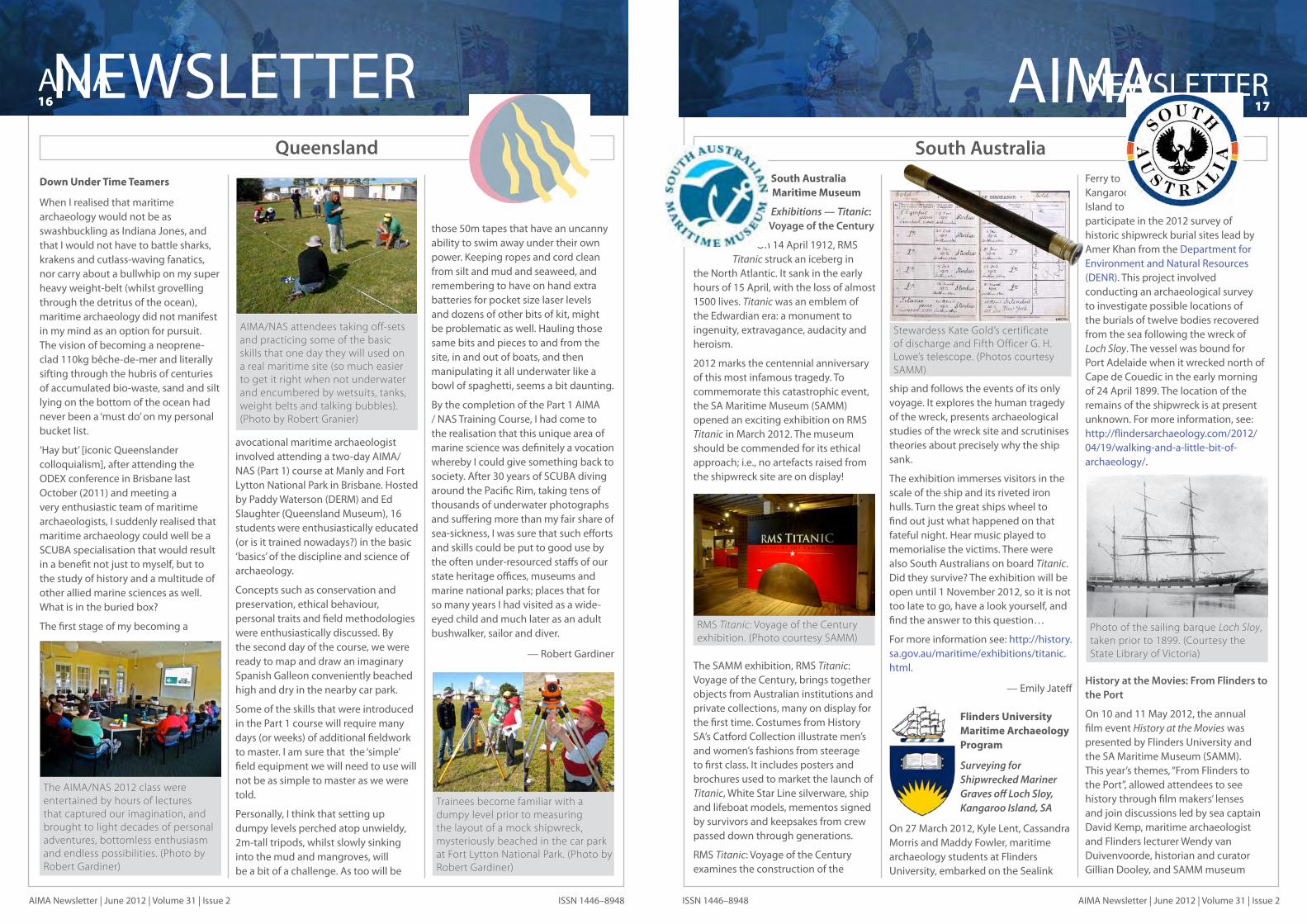
When I realised that maritime archaeology would not be as swashbuckling as Indiana Jones, and that I would not have to battle sharks, krakens and cutlass-waving fanatics, nor carry about a bullwhip on my super heavy weight-belt (whilst grovelling through the detritus of the ocean), maritime archaeology did not manifest in my mind as an option for pursuit. The vision of becoming a neoprene-clad 110kg bêche-de-mer and literally sifting through the hubris of centuries of accumulated bio-waste, sand and silt lying on the bottom of the ocean had never been a ‘must do’ on my personal bucket list.
‘Hay but’ [iconic Queenslander colloquialism], after attending the ODEX conference in Brisbane last October (2011) and meeting a very enthusiastic team of maritime archaeologists, I suddenly realised that maritime archaeology could well be a SCUBA specialisation that would result in a benefit not just to myself, but to the study of history and a multitude of other allied marine sciences as well.What is in the buried box?
The first stage of my becoming a
avocational maritime archaeologist involved attending a two-day AIMA/NAS (Part 1) course at Manly and Fort Lytton National Park in Brisbane. Hosted by Paddy Waterson (DERM) and Ed Slaughter (Queensland Museum), 16 students were enthusiastically educated (or is it trained nowadays?) in the basic ‘basics’ of the discipline and science of archaeology.
Concepts such as conservation and preservation, ethical behaviour, personal traits and field methodologies were enthusiastically discussed. By the second day of the course, we were ready to map and draw an imaginary Spanish Galleon conveniently beached high and dry in the nearby car park.
Some of the skills that were introduced in the Part 1 course will require many days (or weeks) of additional fieldwork to master. I am sure that the ‘simple’ field equipment we will need to use will not be as simple to master as we were told.
Personally, I think that setting up dumpy levels perched atop unwieldy, 2m-tall tripods, whilst slowly sinking into the mud and mangroves, will be a bit of a challenge. As too will be
those 50m tapes that have an uncanny ability to swim away under their own power. Keeping ropes and cord clean from silt and mud and seaweed, and remembering to have on hand extra batteries for pocket size laser levels and dozens of other bits of kit, might be problematic as well. Hauling those same bits and pieces to and from the site, in and out of boats, and then manipulating it all underwater like a bowl of spaghetti, seems a bit daunting.
By the completion of the Part 1 AIMA / NAS Training Course, I had come to the realisation that this unique area of marine science was definitely a vocation whereby I could give something back to society. After 30 years of SCUBA diving around the Pacific Rim, taking tens of thousands of underwater photographs and suffering more than my fair share of sea-sickness, I was sure that such efforts and skills could be put to good use by the often under-resourced staffs of our state heritage offices, museums and marine national parks; places that for so many years I had visited as a wide-eyed child and much later as an adult bushwalker, sailor and diver.
— Robert Gardiner
Queensland
AIMA/NAS attendees taking off-sets and practicing some of the basic skills that one day they will used on a real maritime site (so much easier to get it right when not underwater and encumbered by wetsuits, tanks, weight belts and talking bubbles). (Photo by Robert Granier)
The AIMA/NAS 2012 class were entertained by hours of lectures that captured our imagination, and brought to light decades of personal adventures, bottomless enthusiasm and endless possibilities. (Photo by Robert Gardiner)
South Australia Maritime Museum
Exhibitions — Titanic: Voyage of the Century
On 14 April 1912, RMS Titanic struck an iceberg in
the North Atlantic. It sank in the early hours of 15 April, with the loss of almost 1500 lives. Titanic was an emblem of the Edwardian era: a monument to ingenuity, extravagance, audacity and heroism.
2012 marks the centennial anniversary of this most infamous tragedy. To commemorate this catastrophic event, the SA Maritime Museum (SAMM) opened an exciting exhibition on RMS Titanic in March 2012. The museum should be commended for its ethical approach; i.e., no artefacts raised from the shipwreck site are on display!
The SAMM exhibition, RMS Titanic: Voyage of the Century, brings together objects from Australian institutions and private collections, many on display for the first time. Costumes from History SA’s Catford Collection illustrate men’s and women’s fashions from steerage to first class. It includes posters and brochures used to market the launch of Titanic, White Star Line silverware, ship and lifeboat models, mementos signed by survivors and keepsakes from crew passed down through generations.
RMS Titanic: Voyage of the Century examines the construction of the
ship and follows the events of its only voyage. It explores the human tragedy of the wreck, presents archaeological studies of the wreck site and scrutinises theories about precisely why the ship sank.
The exhibition immerses visitors in the scale of the ship and its riveted iron hulls. Turn the great ships wheel to find out just what happened on that fateful night. Hear music played to memorialise the victims. There were also South Australians on board Titanic. Did they survive? The exhibition will be open until 1 November 2012, so it is not too late to go, have a look yourself, and find the answer to this question…
For more information see: http://history.sa.gov.au/maritime/exhibitions/titanic.html.
— Emily Jateff
Flinders University Maritime Archaeology Program
Surveying for Shipwrecked Mariner Graves off Loch Sloy, Kangaroo Island, SA
On 27 March 2012, Kyle Lent, Cassandra Morris and Maddy Fowler, maritime archaeology students at Flinders University, embarked on the Sealink
Ferry to Kangaroo Island to participate in the 2012 survey of historic shipwreck burial sites lead by Amer Khan from the Department for Environment and Natural Resources (DENR). This project involved conducting an archaeological survey to investigate possible locations of the burials of twelve bodies recovered from the sea following the wreck of Loch Sloy. The vessel was bound for Port Adelaide when it wrecked north of Cape de Couedic in the early morning of 24 April 1899. The location of the remains of the shipwreck is at present unknown. For more information, see: http://flindersarchaeology.com/2012/ 04/19/walking-and-a-little-bit-of-archaeology/.
History at the Movies: From Flinders to the Port
On 10 and 11 May 2012, the annual film event History at the Movies was presented by Flinders University and the SA Maritime Museum (SAMM). This year’s themes, “From Flinders to the Port”, allowed attendees to see history through film makers’ lenses and join discussions led by sea captain David Kemp, maritime archaeologist and Flinders lecturer Wendy van Duivenvoorde, historian and curator Gillian Dooley, and SAMM museum
Stewardess Kate Gold’s certificate of discharge and Fifth Officer G. H. Lowe’s telescope. (Photos courtesy SAMM)
Trainees become familiar with a dumpy level prior to measuring the layout of a mock shipwreck, mysteriously beached in the car park at Fort Lytton National Park. (Photo by Robert Gardiner)
RMS Titanic: Voyage of the Century exhibition. (Photo courtesy SAMM)
Photo of the sailing barque Loch Sloy, taken prior to 1899. (Courtesy the State Library of Victoria)

AIMA18NEWSLETTER
AIMA Newsletter | June 2012 | Volume 31 | Issue 2 ISSN 1446–8948
NEWSLETTER19AIMA
AIMA Newsletter | June 2012 | Volume 31 | Issue 2ISSN 1446–8948
director Kevin Jones.
Flinders University presented a selection of films from their collection, including documentaries on Matthew Flinders’ exploration of the southern coast, pioneering maritime archaeology (see sidebar below), commercial shipping and rare footage of the heyday of Port Adelaide’s working harbour. This event was part of the 2012 South Australia History Festival, with the theme this year of About Time.
The Flinders Archaeology Blog: One Year On
The Flinders Archaeology Blog has been going extremely well since its redevelopment in 2011. We have a steady stream of new posts—on average around two per week—that represent the broad range of activities in which our students and staff are involved. The blog has an average of about 1,500 hits per month and around 50–70 hits per day, most of which come from search engine traffic. The most interesting statistics, though, are that the top posts for the last 12 months and our ‘Top 5 for 2011–2012’ blog entries were all written by Flinders Maritime Archaeology Program students. They are:
“1. The Magnetometer and its use in Underwater Archaeology” by Alex Kilpa (488 views)
“2. The Methodology of Dendrochronology (Tree-Ring Dating)” by Kyle Lent (440 views)
“3. Side Scan Sonar: The Key to Underwater Survey” by Dennis Wilson (405 views)
“4. The Survivor’s Guide to Practicum: One Man’s Journey to Maritime Fieldwork Enlighten-ment” by Dennis Wilson (352 views)
“5. Lights Cameras…Artefact!” by Danielle Wilkinson (349 views)
For more information, see http://flindersarchaeology.com/2012/05/14/the-flinders-archaeology-blog-one-year-on-3/.
Maritime Archaeology Program—Master Classes
From March to June, the Maritime Archaeology Program organised three master classes for its students. On 27 April, Wendy van Duivenvoorde organised Researching and Recording Anchors, which taught students the specialised terminology of anchors, how anchors developed through history, and how to record archaeological or historic anchors.
Jennifer McKinnon ran Ships as Material Culture on 4 May, in which students learned how ships are constructed, including materials types, techniques for construction and the finishing touches of fitting out ships.
Then, on 8 June, students participated in a master class that led them behind the scenes of the SA Maritime Museum. Organised by Jennifer McKinnon, it provided an opportunity for participants to delve into the SAMM collections at the Museum’s Netley
Facility. Together with Emily Jateff, curator at SAMM, the students explored collections that are not on display in the Museum. Dirty old boats, nautical paintings and other maritime treasures were all part of the tour and the students had much fun peaking behind the curtains in the collection storage! It was a great opportunity to learn how Emily manages these collections on a daily basis. She discussed important issues such as disaster preparedness, de-accessioning, collection acquisitions and conservation, and then the students got some hands-on experience with accessioning actual objects into the Museum collection. Many thanks, Emily, for a great master class!
Recording Rock Carvings in the Bay of Antongil, Madagascar
In April, Flinders University lecturer in maritime archaeology Wendy van Duivenvoorde, Flinders archaeology research associate Mark Polzer and, PhD candidate and rock art specialist Jane Fyfe from the University of Western Australia travelled to Madagascar to examine and record rock inscriptions left behind by officials and seamen of the Dutch East India Company on Nosy Mangabé Island in the Bay of Antongil. The bay is located on the northeast corner of Madagascar, and was known as a place on the South East Asia route where ships could replenish their fresh water supplies and drop
anchor to ride out storms or conduct repair work. The Dutch started using the beach as a communications area by inscribing messages on the rock faces and frequently leaving letters for other ships to pick up. Basically, it served as an early postal system, or a post restante—the only one from the time of early European seafaring into the Indian Ocean that remains in situ. For more information, watch the video at http://player.vimeo.com/video/42171028?title=0&byline=0&portrait=0 or read the full story at http://www.flinders.edu.au/ehl/fms/archaeology_files/dig_library/graduate%20program/ENGAGE-Jun2012.pdf.
Kyrenia Ship Publication Project and Anchor Reconstruction project
In June 2012, Wendy van Duivenvoorde travelled to Cyprus to commence the full-size scale reconstruction of the Kyrenia ship’s anchor and to work with Laina Swiny and Robin Piercy, two members of the original excavation team of 1968, on the final publication of the shipwreck. Sponsored by the Kyrenia Ship Publication Project, the full-size reconstruction of the Kyrenia ship’s anchor will be undertaken by
Kleanthis Moustakas, a long-standing colleague in the Kyrenia ship project. He sailed on Kyrenia II and Kerynia Liberty and has been involved with several experimental archaeology projects for the shipwreck’s final publication. Kleanthis has studied the ancient art and craft of Cyprus, both on the island and farther afield in Greece and the UK. He works as an archaeologist, but also has skills that include icon painting, stonemasonry, and mosaic making.
SA Maritime Museum curator Emily Jateff helps Flinders MAP students accession objects in the Museum’s Netley Facility. (Photo Wendy by van Duivnevoorde)
“On 11 June 1770 the sailing ship Endeavour, captained by James Cook, struck a submerged reef off the northeast coast of Australia
and ran aground. In an effort to lighten the load to float the ship off the reef, all unnecessary equipment was thrown overboard. The jettisoned cargo included six cannons. In 1969 a group of scientists landed on Hope Island, between Endeavour Reef and the Queensland coast, determined to find the lost cannons. In a search shrouded in secrecy and using the very latest scientific equipment the men were able to locate the cannons and bring them to the surface, after nearly 200 years on the ocean floor.”
— Container
Title: Six Fish and a Ton of SinkersRun time: 24 minutesProducer: Roland BeckettWriter: Michael BoddyNarrator: Raymond du PareExpedition photographer, Vincent Vlassof
Produced by the Australian Commonwealth Film Unit for the Commonwealth Department of Shipping and Transport, 1971.
Students attend the master class ‘Ships as Material Culture’ at Flinders University. (Photo by Jennifer McKinnon)
Early 17th-century Dutch inscription on the rock face of Nosy Mangabé in the Bay of Antongil, Madagascar. (Photo by Mark Polzer)
Kyrenia II, the first experimental replica of the ancient ship, sailing in the Aegean Sea during sea trials. It now resides in the Thalassa Museum in Ayia Napa, Cyprus. (Photo courtesy the Kyrenia Shipwreck Project)
Kleanthis Moustakas uses traditional tools to fashion the replica anchor for use onboard Kyrenia Liberty. (Photo by Wendy van Duivenvoorde)
Early morning view of Nosy Mangabé from the mouth of the Ambodiadabo River. (Photo by Mark Polzer)

AIMA20NEWSLETTER
AIMA Newsletter | June 2012 | Volume 31 | Issue 2 ISSN 1446–8948
NEWSLETTER21AIMA
AIMA Newsletter | June 2012 | Volume 31 | Issue 2ISSN 1446–8948
Kleanthis’ ethos is to use the authentic materials employed by contemporary workmen and artists, which makes him the perfect person to make the Kyrenia ship’s anchor reconstruction. He is using traditional tools and materials—for example, oak compass timber from the Trodoos Mountains, Cypriot copper from local mines, and regional lead for the construction of the anchor stock.
PhD Studies in Maritime Archaeology
James Hunter III submitted his PhD dissertation in May 2012 with the title: Throwaway Navies: Naval Transition, Abandonment Process, and the Archaeology of Australia’s Torpedo Boat Defences 1884–1924. Then, the Department of Archaeology welcomed two new PhD students this semester, Maddy Fowler and Gay Lacsina, who both commenced maritime-related PhD research topics.
Maddy Fowler’s PhD study aims “to understand issues related to Indigenous and European cross-cultural interaction, specifically adaptation and change of maritime technologies. This research fits into a field of archaeology commonly referred to in literature as contact period archaeology, the archaeology of culture contact and the recent Indigenous past. It will primarily address the question: how do issues of the incorporation and/or modification of European boat building traditions and techniques relate to issues of Indigenous Australian cultural continuity or the application of traditional knowledge? This research will focus on a material culture analysis of European style vessels (marine and riverine) to examine Indigenous use of European boat building traditions. The study area will be confined to mission associated watercraft. This research is significant because archaeological evidence will provide a different data set to the previous historical and ethnographic records on the topic and will produce comparative results.” (PhD Proposal summary, Maddy Fowler. Supervisors: Jennifer McKinnon and
Amy Roberts).
Gay Lacsina commenced a PhD study on the traditional watercraft of island Southeast Asia by re-examining their archaeological remains in Philippine sites.
In the 1970s, the so-called Butuan boats were discovered in Butuan City, southern Philippines. A total of nine round bottom boats were found buried beneath flood deposits along what is believed to have been the banks of a river. Three of the boats were excavated and radiocarbon dated. The results of the dating, 320 CE, 1215 CE and 1250 CE, respectively, revealed the oldest (notwithstanding some skepticism regarding the 320 CE date), and best preserved archaeological evidence of Philippine watercraft. The vessels average 15m in length and 3m in beam, and exhibit the building techniques described in a 17th-century account by Spanish priest Francisco Alcina.
Other sites with evidence of similar boatbuilding technology are the San Isidro and the Gujangan wrecks. In 1996, in the waters of San Isidro, Zambales province in the northwest Philippines, a vessel approximately 15m long carrying Ming Dynasty Chinese ceramics (ca 16th century CE) was discovered. It was postulated that the wreck at San Isidro acted as a lighter for larger vessels that were unable to moor closer to shore. Though much of the hull was obscured by cargo and concretions, small wooden pins were
observed. The San Isidro hull remains indicate that it may have been clinker-built, unusual for Philippine vessels. This, however, needs to be verified by further field research.
The heavily looted Gujangan wreck was found in the waters off Gujangan Island, Sulu province, southern Philippines. The wreck, dated to the 15th–16th century CE based on its ceramic cargo, was inspected by archaeologists in 1998, who noted bored lugs indicative of lashed-lug construction. They are remarkably similar to the Butuan boat planks.
The San Isidro keel and planks were recovered for documentation, but were returned to the site due to the difficulty of wood conservation. The Gujangan hull was left in situ, though some plank fragments were recovered for sampling. Neither of the sites have been re-examined since the initial investigations. Meanwhile, at least six Butuan Boats remain unexcavated.
Specific research goals include the radiocarbon dating of the unexcavated Butuan boats, the precise recording and documentation of the unexcavated Butuan boats and the hulls of the San Isidro and Gujangan wrecks, and a thorough comparative study of the archaeological remains. (PhD Proposal summary, Ligaya S.P. Lacsina. Supervisors: Jennifer McKinnon and Wendy van Duivenvoorde).
Conferences, Public Lectures, and More
While Wendy was in Cyprus, Jennifer McKinnon travelled to Saipan to present a key note lecture “Beyond the water’s edge: investigating underwater wrecks from the Battle of Saipan” at the 1st Marianas History Conference from June 14–16, 2012.
She returned home with the exciting news that she has been promoted to Senior Lecturer in Maritime Archaeology. Congratulations on a much deserved promotion!
— Wendy van Duivenvoorde
One of the Butuan Balangay boats on display in the Philippines National Museum.
VictoriaClarence Excavation and Rapid Recording, April/May 2012
In 2011, the Australian Research Council (ARC) awarded a 10 Partner Organisation Linkage Grant for the Australian Historic Shipwreck Preservation Project (AHSPP), aka, ‘The Clarence Project’, with the grant coming on line in February 2012. The project is investigating the excavation, rapid recording, reburial and in situ preservation of threatened shipwrecks and their associated artefacts.
The project will run for three years and involves fieldwork with Investigators from the University of Western Australia (UWA), the Australian National University (ANU), Monash University and the Western Australian Museum (WAM), supported by Research Associates and practitioners from State, Territory and Commonwealth Partner Organisations and the Australasian Institute for Maritime Archaeology. Practitioners, students and volunteers (many of whom are AIMA members) are key participants in the project, which has involved over 75 people to date—both directly and indirectly.
Clarence was a small schooner (54x18ft), and is one of just a handful of early Australian-built wooden coastal traders to have been intensively recorded by maritime archaeologists. It was built in 1841 by William Lowe at his Deptford shipyard on the Williams River at Clarence Town (NSW); Lowe also constructed the first Australian-built paddle steamer.
Wrecked while anchored in the Coles Channel in Port Phillip in 1850, the site is located less than 3km from St Leonards boat ramp, and only 1km off shore from closest landfall (Point Edwards) on the Bellarine Peninsula. The site is subject to tidal currents from Port Phillip Heads ranging from 0.4 up to 1.75 knots. Slack water at the site was
usually once per day during fieldwork, and lasted anywhere from 5 to 30 minutes.
The site lies in 5m of water within a 100m radius protected zone. The zone is primarily aimed at preventing access by anglers, whose activities—namely anchor damage—on and around the site have caused its degradation over the years.
Heritage Victoria (HV), in its previous incarnation as the Victoria Archaeological Survey, has undertaken several seasons of fieldwork on the site since the mid-1980s, including survey, sediment profiling and excavation. Since then, HV has continued to monitor the site and undertake compliance activities. As manager of the shipwreck site and its protected zone, HV is providing considerable staff and logistical support to the project, including use of its boat (Trim) during lead-up reconnaissance trips and the major fieldwork period (now concluded), follow-up fieldwork and monitoring (which is ongoing). Heritage Victoria is also hosting Cass Philippou’s position as Project Manager at its Conservation and Research Centre in Abbotsford.
Early in April 2012, the excavation team converged on Melbourne for the first and primary field season on Clarence. The fieldwork commenced on 13 April and ran through 12 May 2012.
The multi- disciplinaryrotating team (with a maxi-mum of 30 at any one time) were housed in group accommodations at Portarlington, and diving operations took place from JUPB1, a jack-up barge located directly adjacent the site. The barge was towed to the site by tug from Port Melbourne, and the platform itself, once ‘jacked up’ on its spuds (legs), sat about 3m above the waterline. Three shipping containers on the barge housed the conservation and recording facilities and the diving control room.
Divers, conservation and artefact recording teams travelled out to site and JUPB1 each day aboard Trim, with replacement teams being collected from the nearby St Leonard’s boat ramp. Two buddy pairs were usually in the water working on a range of tasks simultaneously, while dive tenders assisted with the diving supervision topside. Meanwhile, recovered artefacts were rapidly assessed for their individual significance and conservation requirements, catalogued, recorded, photographed and/or x-rayed, then wrapped in geotextile and placed in holding containers until their return to the site.
The majority of the participants arrived on 16 April, with people rotating throughout April and May. Over the course of the month, 68 researchers, students and volunteers from around Australia, as well as international participants from New Zealand, the United States, Thailand, Indonesia, the Philippines and Cambodia, contributed to the field program. This work comprised archaeological and biological survey, scientific sampling (sediment cores and wood samples), excavation, artefact recording and site and artefact reburial. The diving component was compliant with Australian Standards for commercial diving using surface supplied air (SSBA)
JUPB1 being towed out to the site early on the morning of 12 April 2012. (Photo by Cass Philippou)

AIMA22NEWSLETTER
AIMA Newsletter | June 2012 | Volume 31 | Issue 2 ISSN 1446–8948
NEWSLETTER23AIMA
AIMA Newsletter | June 2012 | Volume 31 | Issue 2ISSN 1446–8948
and tethered SCUBA systems with hard-wired surface communications. The first week of the project also saw a group of 11 divers undertaking commercial diver training from the jack-up barge, including a number of practitioners.
The core team consisted of Lead Chief Investigator Professor Peter Veth, Partner Investigators Vicki Richards and Ian MacLeod, Heritage Victoria’s Manager Maritime Heritage Peter Harvey, Diving Supervisor James Parkinson, Chief Investigator Dr Mark Staniforth, Research Associates Debra Shefi, Andrew Viduka and Mike Nash, researchers Dr Jennifer Rodrigues and Amer Khan, and Project Manager Cassandra Philippou.
Other researchers from the 10 Partner Organisations and numerous local, interstate and international students and volunteers attended for periods ranging from one to three weeks of the field program.
The team was fortunate to be dealt excellent weather and sea conditions for the first week, allowing them to carry out a pre-disturbance survey and record baseline data. Divers installed fixed survey points for use throughout the excavation, stabilised the wreck’s hull and filled and deposited 1,250 UV stabilised polywoven sandbags near the site for reburial works. Core samples for geo-archaeological and chemical analysis were taken both on and off site.
The research design specified that only the starboard half of Clarence would
be excavated during the project. Not only would this be representative of the archaeological potential across the wider site, but, importantly, the starboard side was documented to be at risk. It is estimated from surveys carried out in the mid-1980s and more recent site inspections that from 30–75 cm of sediment and archaeological deposits have been lost due to site disturbance and scouring. There was clear evidence of serious and ongoing anchor damage, most easily seen by the loss of profile of the port side frames and reduced levels at the stern.
Excavation of the starboard side commenced at the stern on 21 April. Sediment was removed from the site using a water dredge operated from JUPB1 and controlled by divers below. Sediment traps were created at both bow and stern to contain as much of the spoil as was possible in the current.
Mid-Autumn was selected for the fieldwork for its stable weather patterns in this region. Unfortunately, the team suffered unseasonable bouts of poor weather despite this predictive approach. Even with the challenge
of difficult transfers from the vessel to JUB1, the team only lost a total of 10 non-diving days out of the 27 field days allocated. Excellent use was made of the 17 diving days, with 167 individual dives completed totaling over 181 hours of bottom time logged. James Parkinson of Professional Diving Services (PDS) reported that this was an exceptional outcome for such a field season on tethered scuba and SSBA.
The team excavated a starboard section of Clarence that extended from the stern some 11m along datums towards the bow, ending just aft of a large mast-step and leaving approximately 5m forward of this unexcavated. Although this remaining area was excavated in the 1980s, the substantial lower clay unit beneath the comparatively unconsolidated marine sediments (now known to be pipe clay or kaolinite ballast) was left in situ. The decision to cease excavation at this point was in recognition of days lost due to inclement weather and the re-scoping of reburial and conservation tasks. The excavation also took longer than predicted, given the plasticity, weight and additional labour required to remove this very significant clay unit. The volume of deposit excavated, area of timbers exposed and size of the
View to stern of the excavation trench, starboard side of Clarence. (Photo by Deb Shefi)
Divers Brad Duncan and Mike Nash preparing for their dive. (Photo by Cass Philippou)
artefact assemblage recovered was ideal for the recording and reburial trial. Only the interior of the wreck was excavated, and all exposed timbers and artefacts were measured in situ using hand held tapes attached to a network of datum points. Excavated trenches were drawn to scale using a 1x1m grid square. The measurement data and sketches were later transferred into the Site Recorder4 GIS program by SA state maritime archaeologist Amer Khan.Artefacts, primarily timber barrel staves and lids and fragments of leather, were exposed from the first day of excavation. All artefacts were measured and photographed in situ prior to removal and transfer to the surface. On deck, conservation scientists and artefact specialists undertook rapid significance and conservation assessments, detailed imaging by photography and x-ray, morphometric measurements and cataloguing. Artefacts were then prepared for reburial with their individual identifiers, wrapped in geotextile and eventually returned to the seabed.
One hundred and two artefacts were recorded in the project artefact database, with 109 pieces in total. The majority of the artefacts were parts of four timber barrels that were laying end to end lengthways on the hull. These tierce-sized casks had multiple components (staves, hoop fragments, lids and bases), as well as dunnage (packing material), accounting for the large number of individual artefacts recorded. Other artefacts included leather fragments, cordage and glass. All of these artefacts were returned to the seabed, with small samples of leather and rope retained for conservation analysis.
During excavation a surprising element to the site was encountered: a substantial layer of fine clay, most likely kaolin pipe clay, overlaying the bottom hull timbers of the wreck. This clay was soon identified as an artefact, and research has indicated that pipe
clay out of Newcastle (NSW) was used as ballast on some ships. This also was common practice in the UK at the time, but Clarence is the first wreck in Australian waters to yield a substantial and well-preserved clay ballast. Detailed analyses are now being carried out by Tony Barham and students at the ANU to geochemically fingerprint point of origin and to fully understand conservation processes on the buried timbers.
In Situ Preservation
Artefact Reburial
An off-site artefact repository was installed in the seabed circa 10m southwest of the stern to contain the
organic artefacts. The repository (or depot) was created by cutting a 3m diameter rainwater tank in half and using a water dredge (after probing different sites with a lance) to settle it into the sediment to a depth of approximate 120cm below surface level.
Wrapped and tagged organic artefacts were placed in the bottom of the repository and backfill from the excavation was re-deposited over them to create an anaerobic environment. Clean washed sediments were then used to top up the repository and a layer of 95% UV shade cloth was placed over the tank and pinned to the seabed with sandbags. The repository will be capped by heavy duty PVC sheeting and contoured concrete weights during
a final reburial program in November. There is more than 50cm of sediment above the highest artefact cache.
Inorganic artefacts, primarily ferrous concretions, were wrapped, tagged and returned to the excavated trench for reburial adjacent to the keelson.
Site reburial
Shade cloth was installed over the excavated trench to act as a sediment trap and backfill from the excavation was pumped by water dredge into the trench. Due to the (expected) loss of some sediment from the spoil containment bund located at the bow, additional washed sediment from sandbags was added into the excavated trench to provide a minimum of 50cm back-fill over the hull timbers and reburied artefacts. The profile of sediments over the excavation at the end of backfilling was noticeably higher than at the start of works.
The reburial process was an intensive and logistical exercise, with divers contending with intractable clay, large lengths of shade cloth in low visibility and strong currents. The decision was made to undertake preliminary reburial to ensure that all exposed elements were buried by an adequate sediment load and covered with shade cloth. At the end of May a return team of Heritage Victoria staff, PDS divers and volunteers, under the guidance of Principal Investigator Vicki Richards, returned to the site for two days to complete the reburial and to obtain baseline core samples from the control sites and the reburied sections, including the depot. Further sandbags were positioned to support the frames and in preparation for final coverage by PVC, geotextile and concrete bags in November.
Sacrificial Samples
A number of timber and metal sacrificial samples were prepared by Vicki Richards with the assistance of volunteers. Three types of timber tokens (Baltic Pine, Sydney Bluegum
John Osmond and Joe Brothers assist Ian MacLeod with cleaning barrel staves. (Photo Jen Rodrigues)
James Parkinson exiting the water. (Photo C Philippou)

AIMA24NEWSLETTER
AIMA Newsletter | June 2012 | Volume 31 | Issue 2 ISSN 1446–8948
NEWSLETTER25AIMA
AIMA Newsletter | June 2012 | Volume 31 | Issue 2ISSN 1446–8948
J5 Submarine Anode Protection Project
and Blackbutt) and a variety of ferrous alloy tokens were attached to plastic plates and buried on the site for future analysis. The shade cloth and eventually the PVC cover will have access ports to allow the sacrificial samples to be recovered every year for the life of the project. Analysis of the reburied samples will provide invaluable information regarding the success of the applied in situ preservation strategy, without recourse to sampling the actual wreck or the reburied artefacts.
Core and artefact sampling
Conservation scientists, James Parkinson and Peter Veth took 15 core samples from locations near the bow, midships and stern, directly from the clay unit as well as control locations off site, for detailed geochemical, physico-chemical and grain-size analyses. Samples were also taken of timber, leather and rope artefacts. Twelve marine cores were taken for geoarchaeological analysis to be carried out by Tony Barham and Masters of Archaeological Science students from
the ANU. These cores will also be used to compare with the results of cores they have taken at nearby terrestrial locations. Replicate cores were taken for all samples and analysis of the cores is in process.
Future work
The conservation science component of the reburial project, while always imagined to be significant, looms as a critical longitudinal task. While all aspects of the overall archaeological research design were sequentially addressed, it became clear that some tasks including artefact documentation, imaging (including x-ray), preparation for reburial and the reburial itself could not be characterised as especially ‘rapid’. Equally the discovery of a significant stratigraphic unit/artefact—the pipe clay ballast—served as a caution that contingencies must be allowed for when intervening on an at-risk wrecksite. Re-scoping of tasks and the research design itself is part of any excavation, but an especially critical one in a reburial exercise.
A final period of intensive fieldwork is planned for November 2012 when a discrete team will return to the site for 10 days to complete the final installation of the in situ reburial stabilisation, protection and monitoring materials. Additional sandbags will be delivered to the site to support upstanding hull timbers before shadecloth is deployed to cover the entire wreck. Once these are in place large PVC tarpaulins will be placed over the entire site to completely cover the wreck as a mound. The tarpaulins will be anchored in place with contoured
concrete blocks (set in situ), with the intention of preventing boat anchors from snagging on the shadecloth and dragging it from the site.
Site monitoring, involving the recovery and testing of timber and metal sacrificial samples, and further sediment cores will be undertaken periodically until 2014 to measure the impact of the excavation and the rate at which the site returns to anaerobic conditions This site monitoring will occur at sample points on the wreck itself and also at the reburial repository located to the stern of the wreck (containing the organic material from the site). This monitoring will ultimately form the quantitative evaluation of the success of the in situ reburial strategy for historic shipwrecks that are at risk in southern waters.
For more information about the project, or to see the daily blogs and images from the excavation, visit the project website at www.ahspp.org.au.
Acknowledgements
The Project acknowledges the time, expertise and equipment provided by AIMA members and practitioners, and our tremendous volunteers. We would especially like to thank the following volunteers: Ian McCann, Des Williams, Sven Bartels, Russell Stewart, Eric Bruning, Michael Gregg, Jane Mitchell, Lyall Mills and John Osmond; and researchers Jennifer Rodrigues, Andy Viduka, Peter Harvey, Mike Nash, Deb Shefi, and Cos Coroneos.
— Cassandra Philippou & Peter VethSchool of Social Sciences
University of Western Australia
Vicki Richards preparing sacrificial samples. (Photo by Jen Rodrigues)
Sacrificial timber samples. (Photo by Jen Rodrigues)
A 2011 AIMA Scholarship ProjectGetunder Dive Club
The aim of this project was to carry out investigative and conservation work on the J5 submarine site off Port Phillip Heads, Victoria. It is hoped that the site can be preserved as part of Victoria’s maritime history by reducing corrosion of the submarine’s pressure hull and frames. The project involved carrying out a general site survey, mapping and corrosion potential survey work to provide information on the site and its current state of deterioration. The data obtained was then used to establish a plan for anode placements within the hull structure, which was carried out through November 2011.
Introduction
The J Class submarines saw service in the British Navy during World War 1 and, at the time of their construction in 1916, were the largest submarines ever built. In all, seven were constructed and were the “state of the art” vessels of their day. At the end of the war, negotiations were made to donate six of the vessels to the Royal Australian Navy (one sub, J6, was sunk accidentally in 1918 by an allied submarine). In 1919, the six submarines, escorted by a support vessel, made the long and arduous voyage to Australia.
The J Class submarines actually had a rather short active life in the RAN, as mechanical problems following their years of active service, together with funding cutbacks, led the Navy to retire the vessels in 1921. By 1922, the decision was finally made to scrap the vessels; all but one (J7) was sold.
The Navy stripped four of the submarines before scuttling them in an area outside Port Phillip Bay known as the Ships’ Graveyard. J1, J2 and J5 were scuttled in 1926, while J4 was scuttled a year later. J3 had been beached in shallow water at Swan Island, Queenscliff, in 1923 to supply electric power, while the last vessel, J7, was eventually scrapped as well in 1930 and sunk at Sandringham to serve as a breakwater for the yacht club.
The submarines scuttled in the Ships’ Graveyard laid undisturbed until scuba divers rediscovered them in relatively recent times. J2 was the first discovered, in 1974, followed by J5 and then J4 in 1982, and J1 in 1984. Of these four subs, the hulls of J4 and J2 are broken, and J1 is in an advanced state of decay.
At the time of planning this project, J5 was regarded as being the most intact, largely because she was scuttled with most of her bulkheads still in place, which have added to her current structural integrity. As such, it became the focus of this preservation study. Unfortunately, the resting place of J5, in 36m of water, is one of the deeper of the four sites, making the underwater tasks reasonably challenging.
The project was conceived by members of the Getunder Dive Club following a 2008 presentation on anodic protection of underwater wreck sites by Dr Ian McLeod or the Western Australian Museum. Project methodology was coordinated in consultation with Heritage Victoria, who also were responsible for
granting relevant permits for the project work. All of the underwater work was carried out by members of Getunder Dive Club using members’ boats and equipment. An underwater multimeter was supplied by Mal Venturoni from Professional Diving Services.
The wreck site is approximately 2 nautical miles seaward from the entrance to Port Phillip Bay. Access to the site requires traversing through Port Phillip Heads and the narrow stretch of water known as “The Rip”, due to the strong and turbulent tidal currents that run through the entrance. The entrance can be dangerous in poor weather conditions, especially for small craft, and the wreck site is subject to ocean swells, necessitating careful planning.
Project Implementation
Site map
The first phase of the project was to prepare a pre-disturbance survey of the J5 wreck site. Teams of divers made a number of dives, which resulted in a sketch map showing relative positions, dimensions and general layout of the site. A baseline was established along the hull and fixed datum points placed at strategic locations, such as at the bow. Position and orientation of all datum points and lines, as well as key features, were determined with GPS coordinates, depth measurements and compass bearings. Plastic labelling discs
Divers examining the submarine’s conning tower. (Photos by )
Historic photograph of J5 submarine. (La Trobe Picture Collection, State Library of Victoria)

AIMA26NEWSLETTER
AIMA Newsletter | June 2012 | Volume 31 | Issue 2 ISSN 1446–8948
NEWSLETTER27AIMA
AIMA Newsletter | June 2012 | Volume 31 | Issue 2ISSN 1446–8948
Eleutheria Survey
Day 10 — Saturday, 2 June 2012
The MAAV survey team met at Patterson River boat ramp for an 8:00 AM start to continue the survey of the Eleutheria shipwreck. Once again, Malcolm Venturoni, of Professional Diving Services (PDS), provided MAAV with use of his work boat, which Russell ‘Rustee’ Stewart skippered. The dive team consisted of Peter Taylor, Des Williams and Celeste Jordan, making her first dive on the site. After loading the boat and motoring out across the Bay to the site, Rustee moored the boat to the site buoy and dropped a shot-line to the wreck. The wind was from the NW at 8–10 knots and there was a slight surface chop.
The team’s three objectives for the day were to 1) replace the broken centre-line metre tape and clear the site of other working equipment, 2) take an accurate measurement of the length of keel to compare with the ship’s build dimensions so that PT can confirm the site plan he is making, and 3) continue recording the wreck’s dimensions along
the port side from the stem.For the first dive, PT, Des and Celeste descended to the wreck to drive two long star pickets into the seabed, one hard against the wreck’s sternpost and the other hard against the stem. The seabed at the stern is quite hard, and driving the picket proved to be quite a chore. The team then moved to the bow and placed the second picket, this time without difficulty, as the seabed there is soft mud. PT and Celeste then secured a tape measure between the pickets, making sure it was not caught on any debris. The distance measured 30.9m, which is very close to the official dimension. The team then proceeded to take dimensions of the hull at the port bow until the end of the dive. We left all our equipment on the seabed for the second dive.
After a 2-hrs surface interval, the dive team descended the shot line again to the stern, then swam along the baseline to the bow, where PT and Celeste resumed recording from pickets A and B. Des toured the wreck site, collecting the star-picket hammer and securing it to the shot-line and cleaning ID tags on the pickets around the site. He noted that the tag on picket J is missing and must be replaced. Des also searched in vain for a weight-belt lost on a dive in December 2010, then continued to clear the site of working equipment.
The team accomplished all of its objectives and made a good start on the port side bow recording. Underwater visibility was excellent for both dives at approximately 12m, and there was a slight current that carried
away the seabed silt disturbed during the recording process. The winter months certainly provide the best working conditions on the wreck.
Day 11 — Saturday, 7 July 2012
The survey team rendezvoused at Paterson River boat ramp for our typical 8:00 AM start. Rustee Stewart served again as coxswain of the PDS boat and carried divers Peter Taylor, Priya Cardinaletti and Des Williams. Mick Whitmore skippered his own boat, taking with him divers Puspendu Ghosh, Youri Casselein and Peta Knott. Joe Brothers also came with a boat and divers Joe and John Osmond, but joined the team at the site.
All boats were on site by 10:15 AM (a bit late, as the PDS boat had to return to the boat ramp for a left bag). The shot line was dropped to the starboard side of the bow area, and all boats remained ‘live’ for the day. The morning had begun cold and foggy, but soon cleared to bright sunshine. There was a light NW wind and the bay had a slight surface chop.
The team’s objectives for the day were to 1) complete the outline survey
Maritime Archaeology Association of Victoria
Des Williams on the Eleutheria wreck site. (Photo by Priya Cardinaletti)
Des Williams and Peter Taylor recording survey measurements. (Photo by Priya Cardinaletti)
were attached at various locations to identify points for data measurements. Physical dimensions of the site were measured with metric tape, and the overall wreck and key details were well recorded with sketches and photographs.
Continuity Mapping
The next phase of the project involved taking a series of electrical resistance measurements within the hull structure. Using the forward most internal point—aft end of the torpedo tubes—as a reference point, measurements were taken at regular intervals using a multimeter specially constructed for use underwater. At the determined measurement points, a pneumatic chisel was used to penetrate through concretion layers to bare metal so that resistance measurements could be taken. This process was repeated at set intervals, working slowly aft inside the hull structure, and required a team of three divers: two to hold the instrument’s two electrodes up to 8m apart while the third diver recorded the readings. This process was completed in a single dive, with a bottom time of approximately 45 minutes and a total dive time of 100 minutes. To achieve this, divers used twin tanks and normal air for the dive and sling tanks with 50% and 100% oxygen for an accelerated decompression.
The compiled data enabled us to construct a ‘resistance map’ showing how intact and ‘connected’ is the submarine hull structure. From this, we were able to identify the optimal positions for sacrificial anodes within the structure. We identified a discontinuity in electrical resistance approximately 34m from the bow. This pinpointed effectively where the hull structure is broken, and was confirmed by visual inspection. From this analysis we were able to treat the hull essentially as two sections that require individual anodic protection. Special thanks to Dr Ian McLeod for his assistance in interpreting the results of the resistance
measurements and in determining proper anode placement.
Anode installation
During this final phase of the project, the team installed anodes on the interior of the submarine hull structure. Analysis of the resistance data led us to conclude that we could obtain the necessary corrosion protection with the placement of two large anodes in the forward section of the hull and two more in the rear section, aft of the area of discontinuity. Funding to purchase the anodes was generously provided by a number of parties, including Scuba Divers Federation of Victoria (SDFV), Dive Industry of Victoria Association (DIVA), Dive Victoria and Victorian Artificial Reef Association (VARS).
The installation work was eventually carried out over three separate diving weekends, with a number of follow-up dive days to secure and finalise the anode placements. Each anode is approximately 1m long and weighs 35kg. The anodes were lowered from
the dive boat along a shot line to the seabed adjacent to the submarine hull. Divers then attached and inflated lift bags and manoeuvred the anodes up and into the hull via an entry point approximately mid-way along the hull. Once in position, divers secured the anode in place with cable ties and clamps. They used a G-clamp, with its shaft ground to a point, to make the electrical connection between the anode and hull frame member.
Site Monitoring
Since installation of the anodes, the team has made several dives to the site to check the integrity of the attachments and fittings and to monitor the rate of decomposition of the anodes. All four anodes show decomposition, which is evidence that they are providing sacrificial protection.
Summary
The J Class submarine wrecks are the only submarine dive sites in Australia. But, besides being popular dive spots for Victorian divers, they have significant historical value. This project was undertaken to determine whether it is feasible to provide corrosion protection to the J5 submarine hull to help preserve this heritage site for the future. During the project work prior to actual anode placements, we saw ongoing deterioration of the wreck. We witnessed the collapse of a number of hull plates, and part of the conning tower also has fallen to the sea bed. During the anode connection process, we discovered how brittle some of the metal frame members are, weakened by deep and extensive corrosion. We hope that the anodes now in place will help reduce further deterioration and damage to the structure, so that it might be enjoyed by divers for many years to come.
Monitoring to date has shown that the anodes are corroding as anticipated, and time will tell whether they fulfil their anticipated role. Eventually, as they corrode significantly, the anodes will need
Diver placing an anode in the J5 hull. (Photos by )
Diver placing an anode in the J5 hull. (Photos by )
to be replaced, and this has been budgeted into the project.
Finally, it is our hope that this work will inspire others to undertake
similar projects to help preserve underwater sites of historical significance.
—Steve Cartlidge and John Corby
In addition to those organisations
and individuals mentioned in the text, we want to thank the State Library of Victoria, for help in researching the J Class submarines, and especially our fellow members of the Getunder Dive Club.

AIMA28NEWSLETTER
AIMA Newsletter | June 2012 | Volume 31 | Issue 2 ISSN 1446–8948
NEWSLETTER29AIMA
AIMA Newsletter | June 2012 | Volume 31 | Issue 2ISSN 1446–8948
Mick and Dave entered the water first and commenced their survey at the stern end to confirm the squareness of the south site grid. They found the survey grid to be 45cm out of alignment in the SE corner at posts J, I and Z-.
PT, Des and Priya formed the second dive. Visibility was excellent at 12m and the water temperature was 10 ºC. PT and Des recorded a datum and re-commenced surveying from the fibreglass marker pole left from their previous work. While Priya photo-graphed the work and site, PT and Des surveyed from posts C and D before moving on to posts D and E and then to posts E and F. At the end of their dive, they moved the progress marker to their new end position.
The third dive team of Puspendu and
Youri proceeded to the starboard side of the stern, where they checked all measurements taken two weeks earlier from posts I and J.
During the 2-hrs surface interval, Rustee and the PDS boat team conducted sidescan sonar runs over an area of 100m2 centred over the wreck. This survey was intended to determine if any wreck material has been scattered over the surrounding seabed in years past by scallop dredges. The survey was completed without incident, thanks to excellent conditions and a flat sea. Although PT still needs to process and analyse the data, he did note two interesting targets that will be investigated during the next site visit.
For their afternoon dive, Mick, Dave, Puspendu and Youri dived the City of Launceston wreck to locate the missing
sash weights for Dr. McLeod. Unfortunately, the team could not find any weights, but they did report a good deal of scouring around the wreck, which has exposed numerous items, such as crockery. MAAV is preparing a full report for MHU.
While Priya stayed in the boat to warm up, PT and Des descended again to Eleutheria in the early afternoon and continued their survey, this time taking measurements
from posts G and H.
After all divers were back on board their respective boats, the team departed for Paterson River and arrived back at the boat ramp mid-afternoon. With the completion of another productive day of survey, MAAV is now VERY close to completing the hull survey and can soon begin tagging items on the wreck and mapping them for the site plan.
MAAV extends their sincere gratitude to Malcolm Venturoni and PDS, Mick Whitmore and Joe Brothers for making their boats available for this work, and to Russell Stewart for assisting the effort as coxswain. Thanks also to all the participating divers, and to Priya Cardinaletti for her photography.
—Des Williams
Sidescan sonar image from the Eleutheria site remote sensing survey. (Image by Peter Taylor)
Site Inspections
Northwest Fieldwork, winter 2012
In June 2012, the Maritime Archaeology
and Materials Conservation Departments of the Western Australian Museum (WAM) embarked on a four-week field trip to visit and inspect three sites—at Port Gregory, Ningaloo and Cossack—along the central and north-western coasts of Western Australia.
The first site visited was the Xantho shipwreck (1872) near Port Gregory,
for which the Lynton station served as base camp. The team for this leg of the trip comprised a mixed contingent of WAM curators, conservators, interns and volunteers, including Mack McCarthy, Ian Macleod, Jon Carpenter, Patrick Baker, Kalle Kasi, Nicolas
Western Australia
of the hull’s port-side, 2) survey the wreck with sidescan sonar during the surface interval, and 3) check distances between survey posts at both ends of the wreck site to ensure that all measurements plot correctly.The divers assembled in three teams and received a briefing on the day’s activities from PT, who reminded all divers to record the depth at the sternpost datum before proceeding with their measuring. As this was Peta Knott’s first visit to the site, she was assigned with familiarising herself with the wreck and tagging items of interest.
The first dive consisted of Puspendu, Youri and Peta. The plan was for Puspendu and Youri to orient Peta to the site before beginning their measurements at the port stern. Unfortunately, before measuring could begin, Youri became separated from the others and so they all decided to return to the shot-line after 22 minutes. Once they were all together again, they ascended to their safety stop and then surfaced.
PT, Des and Priya were the next dive team down, but were joined during their descent by a curious seal. Visibility was excellent at 15m and the water temperature was 9 ºC. PT and Des set fixed tapes on pickets A and B and continued their portside bow survey from the fibreglass progress marker pole left at the end of their last survey dive on 2 June. Priya photographed the work.
John Osmond and Joe Brothers made
the final dive of the morning. They confirmed the bow measurements between pickets A and Z+ and Z+ and P. They then moved aft to survey the hull amidships from pickets D and E. After surfacing and handing over their collected data to PT, their team returned to shore.
After a 69-mins surface interval, Puspendu and Youri dived again from Mick’s boat, with Peta Knott staying onboard to warm up. Puspendu and Youri continued their survey from the sternpost forward along the portside, taking measurements from pickets G and F and from E and F. After surfacing, the divers transferred their recorded data to PT and then departed the site for Patterson River.
PT and Des dived back to the wreck after a 2-hrs surface interval. Priya was still very chilled from the first dive and so remained in the boat. The pair collected the tape measure from picket A and swam to the stern to check measurements between pickets H and Z- and between Z- and I. They then returned to the fibreglass marker at the bow to resume the portside survey from pickets B and C. Thanks to excellent visibility, their measuring of the inner and outer planking and frames proceeded swiftly.
The sidescan sonar survey of the wreck and surrounding area had to be aborted due to a faulty power connection in the PDS boat. The survey will be attempted again during the team’s next site visit. Despite this, it was an excellent day of surveying with a good amount of data recorded. After pulling up the shot-line and changing into warm clothes, the team sped home in the lovely afternoon sunshine on smooth Bay waters.
Day 12, Saturday, 21 July 2012
Once again, the survey team met at Patterson River boat ramp for an 8:00 AM start. Malcolm Venturoni and Mick Whitmore provided the boats, which were skippered by Rustee Stewart and Mick, respectively. The dive teams consisted of Peter Taylor, Priya
Cardinaletti and Des Williams in the PDS boat, and Puspendu Ghosh, Youri Casselein and Dave Liddle in Mick’s boat.
After loading all of the dive gear and survey equipment and getting briefed on the day’s dive plan by PT, the teams set off for the wreck site. Rustee expertly dropped the shot line close to picket C on the portside of the wreck, while Mick dropped anchor upwind of the wreck and drifted back close to the shot-line buoy. Rustee kept the PDS boat ‘live’ throughout the day for safety. It was a beautiful morning, although very cold, with a light fog and a 5-knot breeze from the NW. Sunshine improved throughout the morning and the fog quickly burned away. The breeze dropped as well, leaving smooth water.
A full slate of work was planned for the day, with the team’s objectives being for 1) Youri and Puspendu to check the stern starboard side measurements from posts I and J, 2) Mick and Dave to measure and trilaterate picket posts G, H, Z-, I and J at the stern end of the site grid to check that they are square, 3) PT and Des to continue surveying along the port side from post C, 4) Priya to photograph the diving operations and items of interest, 5) PT and Rustee to survey the site and surrounding area with sidescan sonar during the diving surface interval, and 6) Mick, Dave, Puspendu and Youri to recover sash weights from the stern of City of Launceston for Dr Ian McLeod’s ongoing corrosion survey.
Puspendu Gosh and Youri Casselein surveying the Eleutheria hull remains. (Photo by Priya Cardinaletti)
Esteemed coxswain Russell ‘Rustee’ Stewart waits on the surface in the PDS boat. (Photo by Allan Easter)

AIMA30NEWSLETTER
AIMA Newsletter | June 2012 | Volume 31 | Issue 2 ISSN 1446–8948
NEWSLETTER31AIMA
AIMA Newsletter | June 2012 | Volume 31 | Issue 2ISSN 1446–8948
Jeremy led a brief visit to the Norwegian Bay whaling station towards the end of the Ningaloo leg, in order to allow new team members the chance to have a good look around this significant site. Unfortunately, conditions did not permit landing, so after taking a series of photographs from the Museum’s boat Sea Spary, the team headed back to camp.
Ross Anderson joined the team for the final leg of the expedition. To conclude this field work, the museum staff proceeded to Point Samson for a week, with the objective of surveying the shore and waters around the historic port of Cossack, the first site formally designated a port in the Northwest. Several walkover surveys carried out along the shore of Butchers’ Inlet resulted in eight new shipwreck sites being identified and recorded, along with maritime sites and infrastructures, such as an upper landing area, an explosives jetty and magazine, and a seawall. Additionally, a series of magnetometer and side scan sonar surveys of the same inlet allowed the correlation of the location of three magnetic anomalies with historically mapped shipwrecks. Finally, the team accurately positioned and recorded the scattered remains of the Solveig (1903) shipwreck at Point Samson.
Conferences
Computer Applications & Quantitative Methods in Archaeology (CAA)25–28 March 2013
The excitement and achievement
of CAA 2012, recently concluded at Southampton University, England, will be reborn at CAA 2013 in Perth, Western Australia. Jeremy Green and Jennifer Rodrigues are representing the WAM on the organizing committee of the CAA 2013 Perth Conference. Themed “Across Space and Time” and running from 25–28 March 2013 at the University Club, University of Western Australia, the conference brings together researchers
and practitioners from across the world to share their ideas and results. There are already three sessions with maritime or underwater archaeology themes: geophysics, photogrammetry combined with other techniques, and GIS in underwater archaeology. More information will be available soon via the CAA website at http://www.caa2013.org.
Dimensions of the Indian Ocean World Past International Conference12–14 November, 2012
The Western Australian Museum will host an international conference, “Dimensions of the Indian Ocean World Past: Sources and Opportunities for Interdisciplinary Work in Indian Ocean World History, 9th−19th Centuries”, held in November 2012. Jeremy Green represents the WA Museum on the organising committee. Also on the Committee is Maritime Archaeology Department research associate Jun Kimura, from Murdoch University.
Kalle Kasi, Jon Carpeter and Maddy McAllister deploying the cover cloth over Rapid. (Photo by Patrick Baker)
Diver ‘sewing’ sand bags into the cover cloth to anchor it over the wreck and help stabilise the site. (Photo by Jen Rodrigues)
The team prepares the cover cloth on the beach before deploying it on Rapid. (Photo by Jen Rodrigues)
View of the Norwegian Bay Whaling Station from Sea Spray. (Photo by Jen Rodrigues)
Steps on the Cossack wharf and seawall. (Photo by Patrick Baker)
Bigourdan, Maddy McAllister, Ben McKinnon and Jennifer Craig. Three days were allocated for this inspection, the aims of which were to re-locate the wreck, check site conditions and wreck exposure, conduct comparative corrosion measurements, and answer specific research questions. A recent trip by the Maritime Archaeological Association of Western Australia (MAAWA) had failed to locate the site, possibly because it was almost completely buried at the time. After some searching, the WAM team located the wreck; incredibly, it was more exposed than ever had been seen since it was first reported. Consequently, the team was able to carry out corrosion measurements on metallic components
and pilodyne measurements of visible timbers, and also to record new features that previously had been buried beneath silt. The lack of cover also allowed Pat Baker to enhance the Museum’s video and photographic records of Xantho. The team decided to recover a few objects, including one large piece that may be the main steam valve from the ship’s boiler. The objects were immediately transported to Fremantle to begin conservation treatment. The following night and next day saw the typical, stormy winter weather for the region that forced the team to wait it out in camp.For the second leg of the fieldtrip,
the team based out of the Ningaloo station for two weeks in order to conduct a number of different tasks, including surveys and inspections of the numerous assorted shipwreck sites in the vicinity of Point Cloates. At this time, Jeremy and Susan Green and Jen Rodrigues joined the expedition. The team conducted several remote sensing (side scan sonar and magnetometer) and diver surveys in order to accurately demarcate the extent of the Jane Bay Unidentified 1 & 2 shipwreck sites. Locating these sites required several attempts due to weather and tide issues.
The Rapid (1811) shipwreck was given a good deal of attention on this trip in order to deploy a 100-m2 in situ protective shade cloth weighted down by 100 sand bags. Jon Carpenter and Jen Rodrigues first undertook
measurements of the ballast mound and other features to accurately gauge the proper size of the shade cloth. Subsequently, Kalle Kasi and Jon took several corrosion measurements on the anchors. Over the available days, each dive team also inspected the site for any exposed timbers and conducted general inspections amidst their specific assigned tasks. While the diving was underway, others of the team, particularly Nic and Ben, prepared the vast number of sand bags needed. These were deposited at precise locations around Rapid from the work boat, so that when Jon, Maddy and Kalle deployed the shade cloth over the site, they were able to swiftly and efficiently weight it down. Pat Baker recorded the entire procedure with video and photographs.
Finally, the team visited and inspected the shore and shallow reef area within Butterfly Bay, just north of the campsite, following the discovery and reporting of an unidentified wreck site. Besides the wreck, the team was able to locate and record other features and artefacts.
Kalle Kasi and Jon Carpenter take corrosion measurements of Rapid’s anchor. (Patrick Baker)
Jen Rodrigues and Maddy McAllister fight the current while recording wreckage on the Jane Bay Unidentified 2 site near Ningaloo. (Photo by Patrick Baker)
SS Xantho, water colour by Ian Warne. (Image courtesy the WA Museum)
Geoff Kimpton draws the main engine of SS Xantho (top) and uses a torch (bottom) to free it from the shipwreck during the WA Museum’s 1985 recovery operation. (Photos by Patrick Baker)
Jen Rodriguesn and Jon Carpenter measure Rapid‘s ballast pile to properly size the cover cloth. (Photo by Patrick Baker)
AIMA32NEWSLETTER
AIMA Newsletter | June 2012 | Volume 31 | Issue 2 ISSN 1446–8948
NEWSLETTER33AIMA
AIMA Newsletter | June 2012 | Volume 31 | Issue 2ISSN 1446–8948
some 50 miles away, accompanied by a heavy escort that, ironically, was there as a consequence of Emden’s raiding activities. The Australian light cruiser HMAS Sydney (1) was detached to respond.
Around 9:15 AM, the two combatants sited each other and closed to engage, Emden having to abandon her landing party. Although the battle-hardened Emden scored the opening rounds, Sydney closed the range and battered the German vessel. After 90 minutes of intense fighting, Emden was on fire and had lost all but one gun, over half of its crew (dead or injured), and all its boats. Emden’s Captain ordered the ship beached on North Keeling Island to save the lives of his remaining crew.
Meanwhile, the German landing party on Direction Island had watched the battle, perched on the roof of the wireless station alongside the British staff. With the outcome inevitable, the Germans commandeered the derelict copra schooner Ayesha and made for Padang in Dutch Sumatra, the start of one of the all-time great wartime escape stories. At Padang, they caused a diplomatic incident before boarding a German steamer and making their way to the Red Sea, where they fought by sea and land past Lawrence of Arabia’s irregulars, to finally report for duty to the German forces in Constantinople (Istanbul) seven months later…and receive their well deserved Iron Crosses.
Western Australian team on AHSPP project
Vicki Richards and Jen Rodrigues spent four weeks of April and May in Victoria
1914 postcard commemorating the naval victory of HMAS Sydney over the German light cruiser Emden.
with the 60-strong AHSPP (Australian Historic Shipwreck Preservation Project) project team on the Clarence site, led by Professor Peter Veth from the University of Western Australia. They were joined for shorter stints by WAM staff members Dr. Ian MacLeod, Kalle Kasi and Michael Gregg.
(See project article on pages 21–24.)
Museum visits and conference attendance
From late May to June, Jen Rodrigues (Maritime Archaeology Dept.) and Michael Gregg (Maritime History Dept.) visited the National Museum of Australia and the Australian War Memorial in Canberra, after which they represented the WA Museum at the NAWI−Indigenous Watercraft Conference at the Australian National Maritime Museum in Darling Harbour, Sydney, along with Dr Moya Smith from the Anthropology Department of the WA Museum.Jen Rodrigues and Michael Gregg will again represent the WA Museum when they attend the 13th ISBSA (International Symposium on Boat and Ship Archaeology) Conference in Amsterdam in October. They will be joined by Dr. Wendy van Duivenvoorde (Flinders University) and Dr. Jun Kimura (Murdoch University) as part of the Australian delegation. During the conference, all delegates will be visiting Lelystad, in Amsterdam, from where Batavia set sail on her last voyage and where her replica was built. Also included is a tour of the Batavia exhibition in the Niew Land Museum, Lelystad, the collection of which is on loan from the WA Museum’s Department of Maritime Archaeology from October 2011 to November 2012.
Interns and volunteers
Suzanne Jess, a postgraduate student in “Museums and Collections”
from Australian National University, is undergoing an intensive collections management practical internship from July to September in the Department of Maritime Archaeology under the co-supervision of Jen Rodrigues and Maddy McAllister. Suzanne also spent some time in the Materials Conservation Department, under the guidance of Simone Hartneck and Carmela Corvaia, to gain an introduction to glass artefact reconstruction and handling of artefacts following treatment.
University of Western Australia archaeology students Rebecca Ryan, Liam Phillips and Peter Taggart are currently volunteering in the Maritime Archaeology Department to assist Maddy McAllister and Jen Rodrigues in collections management tasks, including collections auditing, artefact photography, cataloguing and collections database processing. The students also are assisting with research and processing of Dutch wreck material and items from other wrecks sites and land excavations. The Department would like to thank them for their invaluable help.
Kate Robertson continues to assist the department in photographing objects, processing the images and uploading them into the collections databases. Kate also helps with supervising the department’s new interns and volunteers in these areas, given her skills, knowledge and considerable experience. In addition, Kate spent a significant amount of time working on designing the new AIMA brochure, including accommodating a host of change requests and edits over several months. A huge thanks to Kate on behalf of AIMA and the Department! Also thanks to everyone who sent in photos for the new AIMA brochure. We hope to rotate some of the images when we next print a new set of brochures.
— Jen Rodrigues, Jun Kimura, Michael Gregg, Maddy McAllister
and Nic Bigourdan
The Conference is organised by the Asian Research Centre at Murdoch University, and thanks to its multidisciplinary focus, is set to be one of the largest international conferences ever held in Western Australia. Experts and early career researchers from various fields will present papers around the three main themes of the Conference:
achievements and opportunities in 1. archaeology;circulation and flow in the Indian 2. Ocean world;climatic impacts in the Indian Ocean 3. World.
Over 60 papers have been accepted, delegated to 18 sessions under these themes. Jeremy Green and Professor Gwyn Campbell (McGill University) will present keynote lectures to interpret historical dynamisms of human activities in the Indian Ocean based on their respective expertise in maritime archaeology and economic history. Three discussants, Dr Paul Lane (University of York), Professor Michael Pearson (University of New South Wales), and Professor Greg Bankoff (University of Hull), are expected to orient various questions by participants into insightful arguments. Participants from a number of overseas institutes, including experts from the British Museum and the Indian Ocean World Centre at McGill University, will address the most recent outcomes of their research. For more information, see the conference website at http://wwwarc.murdoch.edu.au/research/iow_conf.html.
Visiting scholar from Japan
Associate Professor Masako Marui, from Sophia University in Japan, recently visited the Museum for her research on metal ingots from Thai shipwrecks that were excavated during the Thai-Australia Underwater Archaeological Research Project in the early 1980s. She is a specialist in Southeast Asian archaeology, with a particular focus on classical and pre-modern material
culture in the Angkor area. Excavation at Banteay Kdei, originally constructed in the late 12th century in Angkor, unearthed metal lumps from a burial pit for discarded Buddhist statues, deposited after the reign of Jayavarman 7th. Compositional analysis revealed that they were alloys composed mostly of tin with some lead. Ore mining sites of tin and lead have been discovered at nearby sites in Cambodia, which suggests they were probably trading ingots carried by Malay traders in the Gulf of Thai.
Marui is exploring past ingot trade and manufacturing industries in Southeast Asia. She will now focus her research on 15 small lead ingots and one tin ingot from the late 16th−early 17th-century Ko Shi Chang shipwreck and two lead ingots from the Pattaya Shipwreck. Further scientific analysis will be carried out under the coordination of Jun Kimura and Jen Rodrigues to assist in her research. Professor John Watling, of the Forensic and Analytical Chemistry Group at the University of Western Australia, will conduct isotope and elemental analyses of these ingots with the assistance of a PhD candidate from the Forensic Centre who is currently conducting similar analysis of lead bullets. Results from the lead ingot analyses will hopefully add to the database of information being collected.
Exhibitions
Preparations for the anniversary of WWI and exhibitions on ANZAC convoys and the Sydney-Emden story
2014 is the one hundred year anniversary of the commencement of World War I. Preparations are well under way to mark the event, with Michael Gregg from the Maritime History Department tasked with three new exhibitions in the lead up to the anniversary. This will see a complete revamp of the Defence Gallery within the WA Maritime Museum at Victoria Quay, Fremantle, and the creation of two new major travelling exhibitions, each with a unique WA-related story.
One focuses on the story of the ANZAC troop convoys, the first of
which gathered at Albany, WA, at the end of October 1914. The exhibition will feature the stories of those who volunteered, and their experiences that followed, as well as the social impact and political manoeuvring that brought it about.
The second intertwined story concerns a wreck on the isolated Cocos (Keeling) islands off the north-west coast of WA. In 1914, Germany was one of the significant colonial powers in SE Asia, with interests from New Guinea north to Tsingtao (now Qindao, China) and a significant Naval fleet allocated to defended them. In August 1914, with those German colonies under severe threat from the allies, the light cruiser SMS Emden was detached from the German Pacific fleet for commerce raiding in the Indian Ocean.
There followed an extraordinary three-month tale, as this solitary raider brought mercantile shipping in the Indian Ocean to a virtual standstill. SMS Emden’s exploits included the capture or sinking of some 27 allied ships and culminated in two audacious episodes, wherein she sailed right into the British ports of Madras and Penang to sink allied warships.
On 9 November 1914, Emden landed a party on Direction Island, in the Cocos (Keeling) Islands, to destroy the vital cable and wireless station located there. Alert staff sent a continuous distress message until captured by the German landing party. It was enough, however—the message was picked
up by the first ANZAC convoy, passing just
(Top) HMAS Sydney, 1914. (Australian War Memorial, EN0194). (Bottom) Wreck of SMS Emden. (Photo from Der Weltkrieg 1914–1918 in seiner rauhen Wirklichkeit: das Frontkämpferwerk by Hermann Rex [Munich: Moser, 1922])
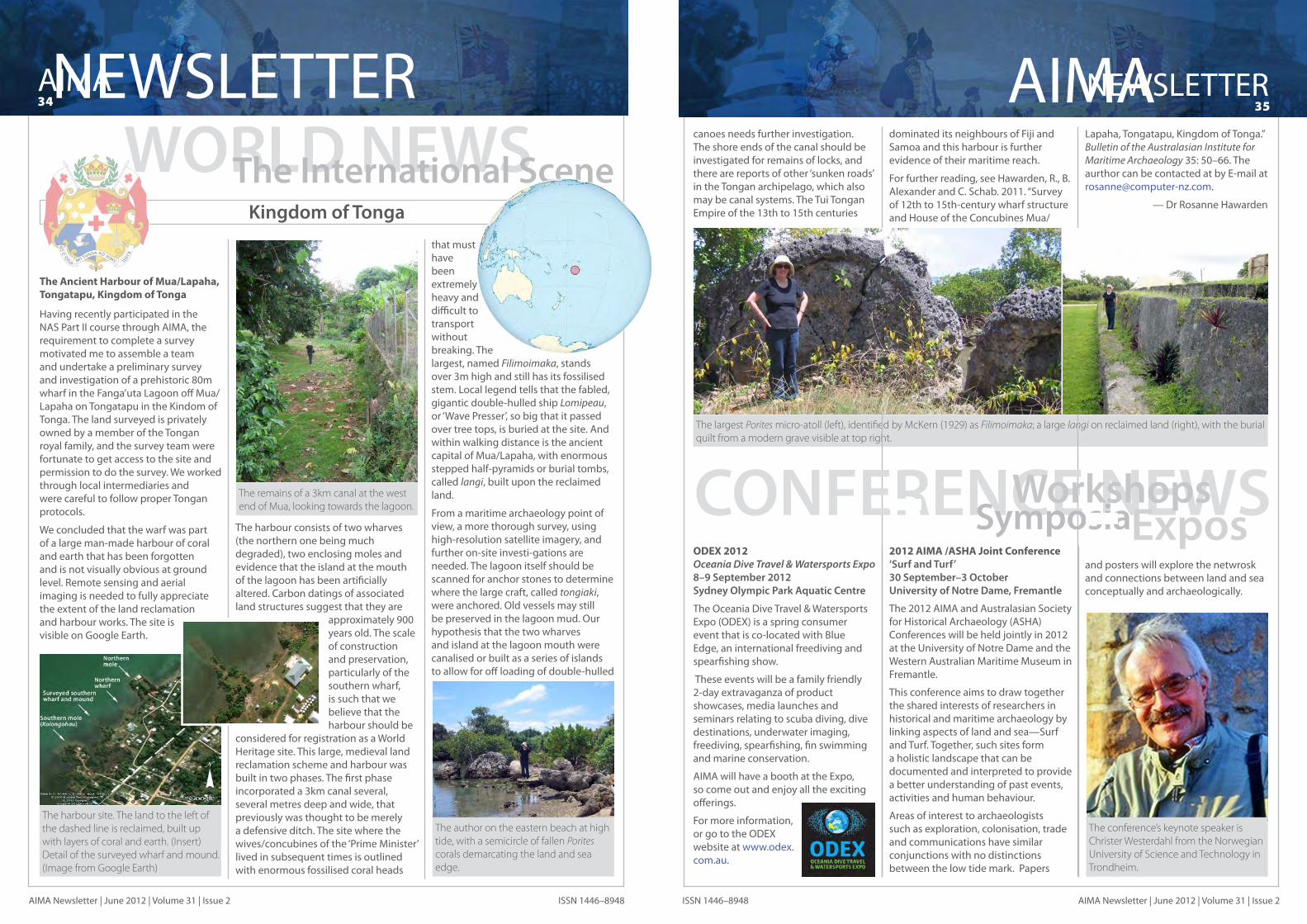
AIMA34NEWSLETTER
AIMA Newsletter | June 2012 | Volume 31 | Issue 2 ISSN 1446–8948
NEWSLETTER35AIMA
AIMA Newsletter | June 2012 | Volume 31 | Issue 2ISSN 1446–8948
canoes needs further investigation. The shore ends of the canal should be investigated for remains of locks, and there are reports of other ‘sunken roads’ in the Tongan archipelago, which also may be canal systems. The Tui Tongan Empire of the 13th to 15th centuries
dominated its neighbours of Fiji and Samoa and this harbour is further evidence of their maritime reach.
For further reading, see Hawarden, R., B. Alexander and C. Schab. 2011. “Survey of 12th to 15th-century wharf structure and House of the Concubines Mua/
Lapaha, Tongatapu, Kingdom of Tonga.” Bulletin of the Australasian Institute for Maritime Archaeology 35: 50–66. The aurthor can be contacted at by E-mail at [email protected].
— Dr Rosanne Hawarden
The largest Porites micro-atoll (left), identified by McKern (1929) as Filimoimaka; a large langi on reclaimed land (right), with the burial quilt from a modern grave visible at top right.
The Ancient Harbour of Mua/Lapaha, Tongatapu, Kingdom of Tonga
Having recently participated in the NAS Part II course through AIMA, the requirement to complete a survey motivated me to assemble a team and undertake a preliminary survey and investigation of a prehistoric 80m wharf in the Fanga’uta Lagoon off Mua/Lapaha on Tongatapu in the Kindom of Tonga. The land surveyed is privately owned by a member of the Tongan royal family, and the survey team were fortunate to get access to the site and permission to do the survey. We worked through local intermediaries and were careful to follow proper Tongan protocols.
We concluded that the warf was part of a large man-made harbour of coral and earth that has been forgotten and is not visually obvious at ground level. Remote sensing and aerial imaging is needed to fully appreciate the extent of the land reclamation and harbour works. The site is visible on Google Earth.
The harbour consists of two wharves (the northern one being much degraded), two enclosing moles and evidence that the island at the mouth of the lagoon has been artificially altered. Carbon datings of associated land structures suggest that they are
approximately 900 years old. The scale of construction and preservation, particularly of the southern wharf, is such that we believe that the harbour should be
considered for registration as a World Heritage site. This large, medieval land reclamation scheme and harbour was built in two phases. The first phase incorporated a 3km canal several, several metres deep and wide, that previously was thought to be merely a defensive ditch. The site where the wives/concubines of the ‘Prime Minister’ lived in subsequent times is outlined with enormous fossilised coral heads
that must have been extremely heavy and difficult to transport without breaking. The largest, named Filimoimaka, stands over 3m high and still has its fossilised stem. Local legend tells that the fabled, gigantic double-hulled ship Lomipeau, or ‘Wave Presser’, so big that it passed over tree tops, is buried at the site. And within walking distance is the ancient capital of Mua/Lapaha, with enormous stepped half-pyramids or burial tombs, called langi, built upon the reclaimed land.
From a maritime archaeology point of view, a more thorough survey, using high-resolution satellite imagery, and further on-site investi-gations are needed. The lagoon itself should be scanned for anchor stones to determine where the large craft, called tongiaki, were anchored. Old vessels may still be preserved in the lagoon mud. Our hypothesis that the two wharves and island at the lagoon mouth were canalised or built as a series of islands to allow for off loading of double-hulled
Kingdom of Tonga
WORLD NEWSThe International Scene
The harbour site. The land to the left of the dashed line is reclaimed, built up with layers of coral and earth. (Insert) Detail of the surveyed wharf and mound. (Image from Google Earth)
The remains of a 3km canal at the west end of Mua, looking towards the lagoon.
The author on the eastern beach at high tide, with a semicircle of fallen Porites corals demarcating the land and sea edge.
ODEX 2012Oceania Dive Travel & Watersports Expo8–9 September 2012Sydney Olympic Park Aquatic Centre
The Oceania Dive Travel & Watersports Expo (ODEX) is a spring consumer event that is co-located with Blue Edge, an international freediving and spearfishing show.
These events will be a family friendly 2-day extravaganza of product showcases, media launches and seminars relating to scuba diving, dive destinations, underwater imaging, freediving, spearfishing, fin swimming and marine conservation.
AIMA will have a booth at the Expo, so come out and enjoy all the exciting offerings.
For more information, or go to the ODEX website at www.odex.com.au.
2012 AIMA /ASHA Joint Conference‘Surf and Turf’30 September–3 OctoberUniversity of Notre Dame, Fremantle
The 2012 AIMA and Australasian Society for Historical Archaeology (ASHA) Conferences will be held jointly in 2012 at the University of Notre Dame and the Western Australian Maritime Museum in Fremantle.
This conference aims to draw together the shared interests of researchers in historical and maritime archaeology by linking aspects of land and sea—Surf and Turf. Together, such sites form a holistic landscape that can be documented and interpreted to provide a better understanding of past events, activities and human behaviour.
Areas of interest to archaeologists such as exploration, colonisation, trade and communications have similar conjunctions with no distinctions between the low tide mark. Papers
and posters will explore the netwrosk and connections between land and sea conceptually and archaeologically.
CONFERENCE NEWSWorkshopsSymposiaExpos
The conference’s keynote speaker is Christer Westerdahl from the Norwegian University of Science and Technology in Trondheim.

AIMA36NEWSLETTER
AIMA Newsletter | June 2012 | Volume 31 | Issue 2 ISSN 1446–8948 AIMA Newsletter ISSN 1446–8948
Jennifer McKinnonFlinders University, ArchaeologyGPO Box 2100ADELAIDE, SA 5001Ph: (08) 8201 5875Fax: (08) 8201 2784E-mail: [email protected] Ross AndersonWA Museum, DMA47 Cliff StreetFREMANTLE, WA 6160Ph: (08) 9431 8442Fax: (08) 9431 8489E-mail: [email protected] Jennifer RodriguesWA Museum, DMA47 Cliff StreetFREMANTLE, WA 6160Ph: (08) 9431 8445Fax: (08) 9431 8489E-mail: [email protected] Andy VidukaDepartment of SEWPaCGPO Box 747 CANBERRA, ACT 2601Ph: (02) 6274 2116 Fax: (02) 6274 2731E-mail: [email protected] RauppFlinders University, ArchaeologyGPO BOX 2100ADELAIDE, SA 5001Ph: (08) 8386 3056Fax: (08) 8201 2784E-mail: [email protected] ShefiFlinders University, Department of ArchaeologyGPO Box 2100ADELAIDE, SA 5001Ph: (08) 8201 2575Fax: (08) 8201 2784E-mail: [email protected]
Bill Jeffery, Vivian Moran,Ed SlaughterBrad Duncan, Sara Ward, Cosmos Coroneos
EDITOR’S NOTE
New Zealand Northern Territory Tasmania South Australia
Western Australia Victoria
Public Officer
Publications Committee
Newsletter Editor
Website Administrator
AIMA/NAS Senior Tutor
AIMA/NAS Committee
Australasian Institute for Maritime Archaeology, Inc. Registration No. A0820044JWestern Australian Associations Incorporation Act 1987 Section 18(6)Newsletter Registered by Australia PostPublication No. WBH 1635
Andy Dodd, Matt Carter David SteinbergMike NashPeter Bell, Adrian Brown, Amer Khan, Wendy van DuivenvoordeVicki Richards, Jim StedmanPeter Harvey, Mark Ryan, Shirley Strachan, Peter Taylor
Corioli Souter
Ross Anderson, Jeremy Green, Peter Harvey, Kieran Hosty, Bill Jeffery, David Nutley, Mark Polzer, Nathan Richards, Myra Stanbury, Wendy van Duivenvoorde
Mark Polzer
Jennifer Rodrigues
Cassandra Philippou
Ross Anderson, Andy Dodd Amer Khan, Peta Knott, Jason Raupp, Ed Slaughter, Corioli Souter, Mark Staniforth, David Steinberg, Hanna Steyne, Sarah Ward
Officers President
Senior Vice President
Vice President
Vice President
Secretary
Treasurer
State Councillors
Queensland
New South Wales
EXECUTIVEAIMA 2011–2012
In February 2012, a new development in the Cape Town Waterfront was brought to a standstill when the
remains of a shipwreck were unearthed. It just so happens that this particular area of the Waterfront was reclaimed from the sea during the second half of the 19th century, explaining the presence of the wreck. The wreckage seems to represent a lightly constructed vessel from no earlier than 1796 (a coin with that date was found under one of
the timbers). Towards one end of the wreck was a large amount of concreted iron, consisting mostly of cannon balls of various sizes and several mystery objects. Included in the latter are bits of what appear to be gear parts and something that resembles a belaying pin. The objects are made from cast iron and are quite heavy. One of our volunteers suggested that the gears could be part of an improved version of the Coles pump of 1803, when the
pump parts were made from iron. The model was discontinued in 1806. Another possibility is that they are parts of a windlass or winch.
Anyone with a suggestion or firm evidence for the identity of these objects is most welcome to contact Jaco Boshoff at [email protected].
— Jaco BoshoffCurator, Colonial ArchaeologyIziko Museums of Cape Town
ARTEFACTSSpotlightCape Town Waterfront Mystery Objects
A large cast iron object resembling a belaying pin (top); two cast iron gear pieces and an unknown iron block with several indentions (lower right); and a smaller cast iron gear (lower left). (Photos provided by Jaco Boshoff ) This issue is packed with great articles and updates
on heritage works and maritime archaeology, conservation and preservation projects. Many thanks to all the contributors. Everyone is encouraged to share your work and interests by contributing fieldwork reports and research summaries; articles on methodologies, tools and intriguing artefacts; as well as book reviews and people profiles. As always, send your contributions, images, comments, questions or suggestions to the editor at [email protected].
The AIMA Newsletter is supported by:
The hisToric shipwecks program
AIMA NewsletterVolume 31, Number 2
June 2012
1
RESOLUTIONS AND RECOMMENDATIONS
RESOLUTION 1 / STAB 3 – Bureau and Agenda
The Scientific and Technical Advisory Body to the Meeting of States Parties to the Convention on the Protection of the Underwater Cultural Heritage, 1. Elects Ms Dolores Elkin (Argentina) Chairperson of its third meeting; 2. Elects Mr Augustus Babajide Ajibola (Nigeria) Vice-Chairperson of its third meeting; 3. Having considered document UCH/12/3.STAB/220/1; 4. Adopts the Agenda included in the above-mentioned document, as amended.
RESOLUTION 2 / STAB 3 – Functioning and Visibi l i ty of the work of the Advisory Body
The Scientific and Technical Advisory Body, 1. Having considered document UCH/12/3.STAB/220/2;
2. Decides
a. to work in a more frequent manner and using electronic means; and
b. to submit agenda items for discussion well in advance of any meeting.
3. Considers it important to increase its visibility; and
4. Decides therefore
a. to increase its visibility through the UNESCO Website by making more information available on the Advisory Body and its work;
b. to seek closer cooperation with media services and educational TV stations;
c. to provide support to conferences and to make presentations on behalf of the Advisory Body at different scientific meetings and organizations;
d. to seek to endorse and contribute to educational or child-related material on underwater cultural heritage.
RESOLUTION 3 / STAB 3 – Cooperation with and Consultat ion of NGOs
The Scientific and Technical Advisory Body, 2. Invites the accredited NGOs to submit proposals on the contributions they may wish to
provide to its work;

2
3. Considers that the work of the accredited NGOs should promote and provide visibility to the 2001 Convention and the Advisory Body and help in the implementation of the Convention;
4. Invites the NGOs
a. to raise awareness of the 2001 Convention, its directions and ethical principles as well as of the recommendations of the Advisory Body;
b. to contribute information concerning specific discussed agenda items;
c. to monitor practical and emerging issues and to propose topics related to them for consideration by the Advisory Body;
d. to identify best practices in underwater archaeology for consideration of the Advisory Body;
5. Invites the Secretariat
a. to facilitate the fluent communication between NGOs and the Advisory Body; and
b. to provide information on minimum standards for the accreditation of NGOs to the Advisory Body so that a greater number of NGOs can be identified for cooperation.
RECOMMENDATION 4 / STAB 3 - Common and Emerging Issues of Underwater Archaeology
The Scientific and Technical Advisory Body,
1. Having considered document UCH/12/3.STAB/220/3;
2. Recommends to the Meeting of States Parties to encourage work and cooperation on
a. Inland water related underwater archaeological research;
b. Sea routes;
c. Submerged prehistoric landscapes and sites, in particular in conjunction with the implementation and promotion of instruments protecting the environment;
3. Does in relation to the upcoming 100th anniversary of World War I,
a. draw special attention to its importance and global, international and humanitarian aspects;
b. call for attention to the endangered situation of the related sites created by natural and human causes;
c. recommend to the Meeting of States Parties to organize in an international effort a commemorative event in the year 2014;
d. recommend to identify appropriate funds for this and to gather related information and material;
e. recommend to also involve States not yet Parties to the 2001 Convention and other international organizations concerned.
3
4. Decides to continue the discussion of this issue by electronic means and to circulate proposals.
RECOMMENDATION 5 / STAB 3 - Financing of Excavations by De-accession of the Artefacts
The Scientific and Technical Advisory Body,
1. Identifies as one of the emerging issues concerning the protection of underwater cultural heritage the current discussion on a possible financing of archaeological services by means of de-accessioning of artefacts; and
2. Recommends to the Meeting of States Parties to consider that the financing of excavations by the process of the de-accessioning of the artefacts from the concerned site is not consistent with the Rules annexed to the 2001 Convention.
RECOMMENDATION 6 / STAB 3 - Education The Scientific and Technical Advisory Body, 1. Having considered document UCH/12/3.STAB/220/4; 2. Recommends to the Meeting of States Parties
a. to introduce topics on underwater cultural heritage in educative material and
curricula of primary, secondary and higher level schools and educational institutions;
b. to develop short films and cartoons for children for publication on the underwater cultural heritage Kids page of UNESCO;
c. to contribute any other appropriate material to this Kids page; and
d. to develop and facilitate cooperation with appropriate children publication
producers. 3. Recommends to the Meeting of States Parties to circulate and exchange appropriate
exhibitions on underwater cultural heritage.
RECOMMENDATION 7 / STAB 3 – Benefits of Protection
The Scientific and Technical Advisory Body,
Recommends to the Meeting of the States Parties
a. to take measures to demonstrate the public interest and utility of the protection of
the underwater cultural heritage;
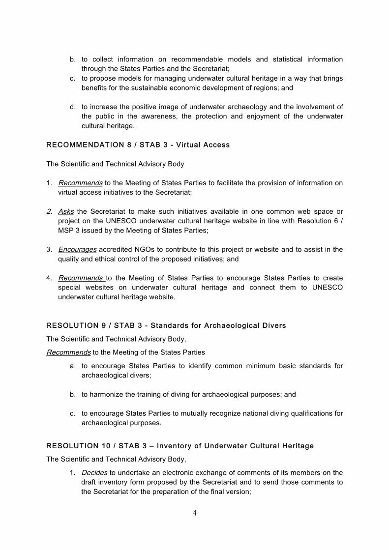
4
b. to collect information on recommendable models and statistical information
through the States Parties and the Secretariat; c. to propose models for managing underwater cultural heritage in a way that brings
benefits for the sustainable economic development of regions; and
d. to increase the positive image of underwater archaeology and the involvement of the public in the awareness, the protection and enjoyment of the underwater cultural heritage.
RECOMMENDATION 8 / STAB 3 - Virtual Access The Scientific and Technical Advisory Body 1. Recommends to the Meeting of States Parties to facilitate the provision of information on
virtual access initiatives to the Secretariat;
2. Asks the Secretariat to make such initiatives available in one common web space or project on the UNESCO underwater cultural heritage website in line with Resolution 6 / MSP 3 issued by the Meeting of States Parties;
3. Encourages accredited NGOs to contribute to this project or website and to assist in the quality and ethical control of the proposed initiatives; and
4. Recommends to the Meeting of States Parties to encourage States Parties to create
special websites on underwater cultural heritage and connect them to UNESCO underwater cultural heritage website.
RESOLUTION 9 / STAB 3 - Standards for Archaeological Divers
The Scientific and Technical Advisory Body,
Recommends to the Meeting of the States Parties
a. to encourage States Parties to identify common minimum basic standards for archaeological divers;
b. to harmonize the training of diving for archaeological purposes; and
c. to encourage States Parties to mutually recognize national diving qualifications for archaeological purposes.
RESOLUTION 10 / STAB 3 – Inventory of Underwater Cultural Heritage
The Scientific and Technical Advisory Body,
1. Decides to undertake an electronic exchange of comments of its members on the draft inventory form proposed by the Secretariat and to send those comments to the Secretariat for the preparation of the final version;

5
2. Decides to make efforts to define the terms used in the draft form; and
3. Decides to add to the form guidelines for national inventories, in particular concerning the electronic storage of data.
RECOMMENDATION 11 / STAB 3 – Replacement of Advisory Body Members The Scientific and Technical Advisory Body,
Recommends to the Meeting of States Parties to take measures allowing the replacement of one of its members with an equally qualified person without new elections in specific situations.
RESOLUTION 12 / STAB 3 - Fourth Meeting of the Advisory Body The Scientific and Technical Advisory Body,
1. Having considered document UCH/12/3.STAB/220/8;
2. Asks the Director-General to convene the fourth meeting of the Advisory Body in April 2013 in Paris following immediately the fourth Meeting of the State Parties.

Australasian Institute for Maritime Archaeology, Inc. GPO Box 2100, Flinders University, Adelaide, SA 5100 Australia
http://aima.iinet.net.au/
Registration No A0820044J Western Australia Associations Incorporation Act 1987 Section18 (6)
ABN 37 830 874 307
The Hon. Tony Burke MP Minister for Sustainability, Environment, Water, Population and Communities PO Box 6022 House of Representatives Parliament House Canberra ACT 2600
6 March 2012
Dear Minister Burke, RE: Historic Shipwrecks Act 1976 review and the UNESCO Convention on the Protection of the Underwater Cultural Heritage 2001 Last year the Australasian Institute for Maritime Archaeology, Inc. (AIMA) wrote to you seeking a meeting to advocate for Australia to immediately pursue ratification of the UNESCO 2001 Convention for the Protection of the Underwater Cultural Heritage. As you may remember, ratification of this Convention is strongly supported by all the Australian states and territories and many members of the public, as it will for the first time enable a mechanism to be put in place that will assist in practically protecting our significant heritage in other nations’ waters. Ratification will also enable Australia to be a part of the International community's response to stopping looting of underwater archaeological sites by prohibiting the sale of these artefacts. AIMA believes that Australia should play a lead role in the Asia-Pacific region in this capacity and should be active in developing underwater cultural heritage management, particularly in nations where Australia has significant shared heritage interest such as Indonesia, Papua New Guinea and the Solomon Islands.
Following our representation, your Deputy Chief of Staff and Heritage advisor Ann-Marie Wilcock met with an AIMA representative in the presence of a departmental officer from the Heritage and Wildlife Division on 7 November 2011. At that meeting Ms Wilcock assured AIMA that you were supportive and cognisant of the need for the protection of our underwater cultural heritage. Ms Wilcock informed AIMA that following the review of the Historic Shipwrecks Act in 2009, it was her understanding that amendment to the Act to enable ratification of the Convention will proceed in 2012 subsequent to the release of the review report. Ms Wilcock suggested that AIMA correspond with you in 2012 to ascertain the progress of amendments to the Historic Shipwrecks Act 1976 and Australia's consideration of ratification, which is why we are writing.
I am pleased to advise, since that meeting AIMA has been formally accredited by UNESCO as a Non-Government Organisation (NGO) member of the Scientific and Technical Advisory Body (STAB) to the State Parties to the UNESCO Convention on the Protection of the Underwater Cultural Heritage 2001. This puts AIMA in a unique and credible position as being recognised to provide the highest level of advice on the management of underwater cultural heritage (UCH) to governments all around the world. Accordingly, AIMA will be sending a representative to the next meeting of the STAB at UNESCO headquarters in Paris on 19 April 2012.
2012 is an exciting year in underwater cultural heritage. It is the 100th anniversary of the sinking of RMS Titanic (1912), whose looting upon discovery precipitated the international community's response to draft and endorse the Underwater Cultural Heritage Convention. 2012 is also the 300th anniversary of the Dutch East India shipwreck Zuytdorp (1712) wrecked off the coast of Western Australia. In 2012 we remember many 70th anniversaries in Australia related to World

War II including the Battle of the Coral Sea in which three US vessels were lost in our waters, the bombing of Darwin Harbour and Sydney where even today the Japanese submarines I-124 and M24 respectively are protected and managed by Australia. 2012 is also the year we remember Australia’s worst single loss of life in World War II with the sinking of the POW ship Montevideo Maru (1942) off the Philippines. While Australia manages the shared underwater cultural heritage in its waters to a standard recognised internationally as best practice, it is the shipwrecks like Montevideo Maru which are important to us and vulnerable. These shipwrecks currently lie outside our jurisdictional controls, however the ratification of the Underwater Cultural Heritage Convention will help us to protect these shipwrecks in a practical day to day manner in collaboration with those coastal nations near each shipwreck site.
It is AIMA's strongly held belief that 2012 offers a number of opportunities to announce that Australia is amending the Historic Shipwrecks Act 1976 and proceeding towards ratification of the Underwater Cultural Heritage Convention in order to protect all of our underwater cultural heritage both at home and abroad. We hope that your department reflects the same view and encourage you to call upon our organisation for any support or assistance in this matter.
I also wish to congratulate you on your announcement that HMS Sirius was included on the National Heritage List, and thank you for your actions and ongoing interest in protecting Australia’s underwater cultural heritage and marine environments.
Yours sincerely,
Dr Jennifer McKinnon
AIMA President
