agricultural lime in central mississippi · james h. may abstract ... clay. contains organic...
TRANSCRIPT

AGRICULTURAL LIME IN CENTRAL MISSISSIPPI
by
ALVIN R. BICKER, JR.
and
JAMES H. MAY
INFORMATION SERIES MGS-77-1
MISSISSIPPI GEOLOGICAL, ECONOMIC AND
TOPOGRAPHICAL SURVEY
WILLIAM HALSELL MOORE
Director and State Geologist2525 N.West Street
P. 0. Box 4915Jackson, Mississippi 39216
1976


AGRICULTURAL LIME IN CENTRAL MISSISSIPPI
by
ALVIN R. BICKER, JR.
and
JAMES H. MAY
INFORMATION SERIES MGS-77-1
MISSISSIPPI GEOLOGICAL, ECONOMIC AND
TOPOGRAPHICAL SURVEY
WILLIAM HALSELL MOORE
Director and State Geologist2525 N.West Street
P. 0. Box 4915Jackson, Mississippi 39216
1976

Suggested cataloging data by the Mississippi Geological Survey:
Bicker, Alvin R.Agricultural lime in central Mississippi.
(Information series - Mississippi Geological, Economic and TopographicalSurvey; MGS-77-1.)
1. Lime industry - Mississippi. 2. Lime - Mississippi. I. May, James H.,joint author. II. Title. III. Series: Mississippi. Geological, Economic andTopographical Survey. Information series ; MGS-77-1.
QE129 MGS-77-1 557.62[TN948.L46] [622.1851]

jiiaie nf JHisstssippt
HON. CHARLES CLIFTON FINCH ~ Governor
MISSISSIPPI GEOLOGICAL, ECONOMIC AND
TOPOGRAPHICAL SURVEY
BOARD
HON. THOMAS H. SPENCER, Chairman - - Jackson
HON. TROY J. LASWELL, Vice Chairman - Starkville
HON. ROBERT L. ABNEY - Bay Springs
HON. GORDON W. GULMON _ -— - - — Natchez
HON. JAMES G. HAWKINS - - - -Columbus

CONTENTS
Abstract
Introduction
Regional Geology .
Field Procedure
Office Procedure ...
Page
.... 1
.... 1
... 1
.... 7
.... 7
Bay Springs Area 8
Page
Heidelberg Area 9
Waynesboro Area 22
Summary and Recommendation 34
Selected References _ 36
Test Hole Descriptions 37
Appendix (Research data and relatedcorrespondence) 49
ILLUSTRATIONS
FIGURES
Outcrop belt of limestone and marl in theOligocene-Vicksburg Group
Correlation of near-surface geologic sectionin western and eastern Mississippi _ 3
Correlation of electrical logs in Hinds andWayne Counties 4
4. Topographic map of Bay Springs area 12
5. Subcrop and isopach of Vicksburg limestoneand marl (Bay Springs) 13
Outcrop of Vicksburg limestone and marland isopach of overlying material(Bay Springs) 14
Calculation areas (Bay Springs) 15
Topographic may of Heidelberg area 18
Subcrop and isopach of Vicksburg limestone and marl (Heidelberg) .19
11.
12.
13.
14.
17.
18.
Calculation areas (Heidelberg) 21
Topographic map of Waynesboro area 26
Subcrop and isopach of Vicksburg limestoneand marl (Waynesboro) .27
Outcrop of limestone and marl nearest tosurface and isopach of overlying material(Waynesboro) 28
15. Subcrop and isopach of Bucatunna clay(Waynesboro) 29
16. Subcrop and isopach of Chickasawhay-Paynes Hammock limestone and marl(Waynesboro) 30
Calculation areas for volume of Vicksburglimestone and marl (Waynesboro) 31
Calculation areas for volume ofChickasawhay-Paynes Hammock limestoneand marl (Waynesboro) .32
10. Outcrop of Vicksburg limestone and marland isopach of overlying material(Heidelberg) 20
19. Calculation areas for overburden(Waynesboro) ...33
TABLES
1. Bay Springs area test hole data summary 10 8.
2. Volume of limestone and marl (Bay Springs) ..11
3. Volume of overburden (Bay Springs) 11 9.4. Heidelberg area test hole data summary 16
5. Volume of limestone and marl (Heidelberg) ..17
6. Volume of overburden (Heidelberg) 17 ...
7. Waynesboro area test hole data summary 23
IV
Volume of Vicksburg limestone and marl(Waynesboro) ...24
Volume of Chickasawhay-Paynes Hammocklimestone and marl (Waynesboro) 24
Volume of overburden overlying Vicksburg(Waynesboro) 25
Volume of overburden overlying PaynesHammock-Chickasawhay (Waynesboro) 25

AGRICULTURAL LIME IN CENTRAL MISSISSIPPI
by
ALVIN R. BICKER, JR.
and
JAMES H. MAY
ABSTRACT
The 1974 Mississippi Legislature authorized theestablishment of a State-operated agricultural limeplant to be located in South Mississippi. The Mississippi Geological Survey was designated as theagency to select the location of the plant site.
Limestone and marls of the Vicksburg Group ofOligocene age contain the only material in sufficientquantity to be effectively used as raw material for aplant. The Vicksburg Group crops out in a narrowbelt that trends northwest-southeast in the south central part of the State near the latitude of Jackson,Mississippi.
Thickness of the Vicksburg Group varies fromapproximately 40 feet near the western end of theoutcrop belt to as much as 90 feet in the east. Chemical analyses show the average calcium carbonate content to be higher in the material located in the east.
On the basis of prior investigations, reconnaissance surveys and transportation requirements threesites were selected for further investigations; onesite located near Waynesboro in Wayne County andtwo sites in Jasper County, one near Bay Springs andthe other southeast of Heidelberg. After thoroughreview of the accumulated data the site near Waynesboro was selected for the location of the proposedplant.
INTRODUCTION
On April 5, 1974, the Mississippi Legislatureenacted into law Senate Bill 2571 establishing authority to the Mississippi Department of Agricultureand Commerce for the construction of an agricultural lime plant in south central Mississippi. TheMississippi Geological, Economic and TopographicalSurvey was designated as the agency to select a plantsite within the outcrop area of the Vicksburg Group.
Recent unsuccessful attempts to enact legislationfor the establishment of an agricultural lime plant insouth Mississippi were conducted during earlier legislative sessions. In 1971, the Geological Survey wasrequested to recommend areas in south Mississippiwhich have surface exposures of limestone that couldbe utilized for agricultural lime. Data collected bythe agency during years of its existence show thatthe most southerly outcrops of limestone in the Stateare in formations of the Vicksburg Group. Uponreceiving the request for locations of limestone outcrops in 1971 the Geological Survey initiated a reconnaissance survey of the outcrop area of the Vicksburg Group. Concurrent with this reconnaissancesurvey was a detailed investigation of the geologyof Smith County, which was completed in 1972. Also
in 1972, a detailed investigation of Wayne Countywas initiated. Reports on the geology of Rankin,Hinds, Jasper and Warren Counties were publishedpreviously. Outcrops of strata of the Vicksburg Groupare present in all of the listed counties. Therefore,when Senate Bill 2571 was passed, the GeologicalSurvey had compiled a large volume of data on thecounties that have exposures of limestone.
REGIONAL GEOLOGY
Limestone in south central Mississippi is presentin strata of the Vicksburg Group and the Chickasaw-hay and Paynes Hammock Formations of Oligoceneage. Formations of the Vicksburg Group are exposedin a narrow outcrop belt that extends from near Vicksburg in Warren County east-southeastward to theMississippi-Alabama boundary in the latitude ofWayne County. The Chickasawhay and Paynes Hammock Formations overlie the Vicksburg Group, butare restricted to the eastern part of the State andare present only in Wayne and Jasper Counties.(Figure 1)
Strata of the Vicksburg Group were referencedby T. A. Conrad in 1846, who observed marls andlimestones containing marine fossils at and nearVicksburg, Mississippi. Surface exposures in the outcrop belt have been described in the followingcounties: Warren (Mellen, 1941), Yazoo (Mellen,1940), Hinds (Moore, 1965), Rankin (Baughman,1971), Smith (Luper, 1972), Jasper (DeVries, 1963),and Wayne (May, 1974).
In the western part of its outcrop area the Vicksburg Group is composed of the Mint Spring, Glendon,Byram and Bucatunna Formations. Eastward in thelocality of Jasper County additional limestone is developed in the lower part of the Vicksburg Group.This additional limestone section is the MariannaFormation. It occupies a stratigraphic position between the underlying Mint Spring Formation and theoverlying Glendon Formation. The Marianna Formation continues to thicken eastward and at some localities in Wayne County the Marianna contributesan additional forty feet of limestone to the total Vicksburg section. (Figures 2 and 3)
Of the above listed formations only the Mariannaand Glendon contain material of sufficient calciumcarbonate content to be successfully utilized as anagricultural limestone. The Mint Spring and ByramFormations are composed predominantly of calcareous, argillaceous, arenaceous, glauconitic marls.Locally, the formations contain thin beds of limestone. Calcium carbonate content of the marls hasbeen reported to be as high as 78 percent and as lowas 17 percent. The calcium carbonate content is
-1—

'-!-'
I BENTON ^ L AUCORN | c
I • r1 L_ _i s1 MARSHALL J T, p p * „ S 1 -
h ! '• i s"^—i un.on fj—I—L.
, LAFAYETTE [ | !
', ! UEE l.TAWA,•O NT OT OC
1 U—I •usha| IWEST POINT LIME PLANTI
TALLAHATCHIEI JCALHOUN I,.„C K A S A W
r1I [R E N A D A I J~~"
•~r
W E BST El
MONROE
! II LOWNDES
ichoc;awj j ,j IMACON LIME PLANTi
j ATTALA L.JWl N STOI
Figure 1 - Outcrop Belt of Limestone and Marl in the Oligocene Vicksburg Group.
—2—
TIO X U 8 EE

f
ST
RA
TIG
RA
PH
ICU
NIT
AL
LU
VIU
M
LO
ES
S
PR
E-L
OE
SS
TE
RR
AC
ED
EP
OS
ITS
CIT
RO
NE
LL
EF
OR
MA
TIO
N
CA
TA
HO
UL
AF
OR
MA
TIO
N
BU
CA
TU
NN
AF
OR
MA
TIO
N
BY
RA
MF
OR
MA
TIO
N
GL
EN
DO
NF
OR
MA
TIO
N
MIN
TS
PR
ING
FO
RM
AT
ION
FO
RE
ST
HIL
LF
OR
MA
TIO
N
WE
ST
ER
NM
ISS
ISS
IPP
I-H
IND
SC
OU
NT
Y
LIT
HO
LO
GIC
CH
AR
AC
TE
R
Sand
,ye
llow
ish-
gray
toye
llow
ish-
oran
ge.
Som
egr
avel
,si
ltan
dcl
ay.
Con
tain
sor
gani
cm
ater
ial
inso
me
loca
liti
es.
Silt
,ta
nto
brow
n.C
onta
ins
foss
ils
ofla
ndsn
ails
.In
east
ern
part
ofco
unty
repr
esen
ted
byw
eath
ered
silt
sco
lled
brow
nlo
om.
Gra
vel,
mul
ticol
ored
,ch
erta
ndqu
artz
.Sa
nd,
red,
fine
-to
coar
se-g
rain
ed.
Occ
asio
nal
clay
lens
esan
dsi
lici
fied
woo
d.
Gra
vel,
mul
ticol
ored
,ch
erta
ndqu
artz
.Sa
nd,
redd
ish-
brow
nto
red,
fine
-to
coa
rse-
gra
ined
quar
tz.
Sand
,gr
ayto
whi
te,k
aoli
niti
c,lo
call
yin
dura
ted.
Gra
y,bu
ff,g
reen
and
purp
lesi
lty
clay
s.
Cla
y,da
rk-g
ray
tobl
ack,
fine
lyca
rbon
aceo
us,
pyri
tifer
ous,
spar
ingl
yfo
ssil
ifer
ous,
thin
sond
lam
inae
.W
eath
ers
toch
oco
late
brow
n.
Mar
l,gr
ay-g
reen
,gl
ouco
niti
c,fo
ssil
ifer
ous,
clay
ey;
slig
htly
sand
yin
low
erpa
rt.
Con
tain
sin
dura
ted
ledg
eson
the
outc
rop.
Lim
esto
ne,g
ray,
foss
ilife
rous
,gl
ouco
nitic
,sa
ndy;
inte
rbed
sof
gray
-gr
een,
sand
y,gl
ouco
niti
c,fo
ssil
ifer
ous
mar
l.
Mar
l,gr
ay-g
reen
,fi
ne-
toco
arse
-gra
ined
,gl
ouco
nitic
,fo
ssili
fero
us;
clay
eyin
mid
dle
port
ion
inso
me
loca
liti
es.
Silt
ysa
nd,d
ark-
gray
,fi
ne-
tove
ryfi
ne-g
rain
ed,c
arbo
nace
ous,
lam
inat
ed,s
pari
ngly
foss
ilif
erou
s.
ST
RA
TIG
RA
PH
ICU
NIT
AL
LU
VIU
M
TE
RR
AC
ED
EP
OS
ITS
CIT
RO
NE
LL
EF
OR
MA
TIO
N
CA
TA
HO
UL
AF
OR
MA
TIO
N
PA
YN
ES
HA
MM
OC
KF
OR
MA
TIO
N
CH
ICK
AS
AW
HA
YF
OR
MA
TIO
N
BU
CA
TU
NN
AF
OR
MA
TIO
N
BY
RA
MF
OR
MA
TIO
N
GL
EN
DO
NF
OR
MA
TIO
N
MA
RIA
NN
AF
OR
MA
TIO
N
MIN
TS
PR
ING
FO
RM
AT
ION
FO
RE
ST
HIL
LF
OR
MA
TIO
N
EA
STE
RN
MIS
SISS
IPP
I-W
AY
NE
CO
UN
TY
LIT
HO
LO
GIC
CH
AR
AC
TE
R
Sond
,ye
llow
ish-
gray
toye
llow
ish-o
rang
e.So
megr
avel,
silt
,cla
yan
dor
gani
cm
ate
ria
l
Sand
,m
ultic
olor
ed,f
ine-
toco
arse
-gra
ined
quar
tz,fe
rrug
inou
s;le
nses
ofch
erta
ndqu
artz
grav
elan
dcl
ay.
Sand
,mos
tlyda
rkye
llow
ish-o
rang
e,fi
ne-t
oco
arse
-gra
ined
,fer
rugi
nous
;co
ntai
nsm
ulti
colo
red
cher
tand
quor
tzgr
avel
.
Sand
,br
own
togr
ay,
fine
-to
med
ium
-gra
ined
(som
ech
ert
grav
el);
inte
rbed
sof
silt
and
clay
;lo
call
yin
dura
ted.
Mar
l,ol
ive-
gray
togr
ayis
h-ye
llow
,fo
ssili
fero
us,
sand
y,gl
ouco
nitic
;in
terb
eds
ofcl
ayan
dcl
ayst
one
ledg
os.
Lim
esto
ne,
oliv
e-gr
ayto
gray
ish-y
ello
w,
foss
ilife
rous
,sa
ndy,
glou
coni
tic;
inte
rbed
sof
mar
lsan
dcl
ays.
Cla
y,li
ghtt
oda
rk-g
ray,
silt
yto
sand
y,m
icac
eous
,ca
rbon
aceo
us,
foss
ilif
erou
s.L
ocal
lybe
nton
itic
.
Mar
l,gr
eeni
sh-g
ray
todo
rkol
ive-
gray
,cla
yey
tosa
ndy,
glou
coni
tic,
foss
ilif
ero
us.
Lim
esto
ne,m
ediu
m-g
ray
tolig
ht-g
ray,
foss
ilife
rous
,py
ritic
,sa
ndy.
Hard
ledg
esw
ith
inte
rbed
sof
mar
l.
Lim
esto
ne,
light
-gra
yto
yello
w!s
h-gr
ay,
foss
ilife
rous
,cl
ayey
.So
fter
and
mor
ehom
ogen
eous
than
over
lyin
gG
lend
on.
Mar
l,li
ghtg
reen
ish-
gray
toda
rk-g
ray,
clay
eyto
sand
y,fo
ssili
fero
us,
glou
coni
tic.
Cla
y,m
ediu
mto
dark
-gra
y,si
lty,
carb
onac
eous
,sp
arin
gly
foss
ilife
rous
.Sa
ndy
inso
me
loca
liti
es.
Figu
re2
-C
orre
latio
nof
Nea
r-Su
rfac
eG
eolo
gic
Sect
ion
inW
este
rnan
dEa
stern
Miss
issip
pial
ong
Vick
sbur
gO
utcr
op.

Figu
re3
-C
orre
latio
nof
Ele
ctri
cal
Logs
inH
inds
and
Way
neC
ount
ies.

usually in the lower percentage figures because ofthe inclusion of clay, sand and glauconite. The Bucatunna Formation is predominantly a micaceous,sparingly fossiliferous clay. Locally, the Bucatunnacontains thin beds of marl or thin lenses of sand.
The Vicksburg Group overlies the Forest Hill Formation throughout the area of outcrop. The nature ofthe contact between the Mint Spring Formation andthe underlying Forest Hill Formation has been reported to be disconformable. The stratigraphic sequence overlying the Vicksburg Group changes fromeast to west along the outcrop from Wayne Countyto Warren County.
In Wayne County the Chickasawhay and PaynesHammock Formations overlie the upper formation ofthe Vicksburg Group. The contact between the Chickasawhay Formation and the underlying BucatunnaFormation is reported as disconformable (May, 1974).In Jasper County the Chickasawhay Formation wasreported not to have been observed at the outcropby DeVries (DeVries, 1963). However, from test holedata DeVries interpreted a fine-grained glauconitic,lignitic sand bed overlying the Bucatunna Formationas the lateral equivalent of the limestone facies of theChickasawhay Formation; From the same test holedata, DeVries reported a 14-foot bed of sand whichhe tentatively correlated as Paynes Hammock Formation. Neither of the above sand zones contain faunalevidence which may suggest the formation to whichthey belong. However, the glauconitic nature may beindicative of marine deposition and suggests it mayhave been deposited during the late Oligoceneage. Normally at surface localities in Mississippi,lower Miocene sands have not been reported to beglauconitic, although rare glauconite has been reported in the subsurface.
In Smith county, Luper (Luper, 1972) reportedthe Miocene age Catahoula Formation to overlie theBucatunna Formation unconformably. AlthoughLuper did not report the presence of late Oligoceneage sediments in Smith County, other writers haveassigned strata present at the surface in the southeastpart of the county to the Paynes Hammock Formation. MacNeil (MacNeil, 1944) reported the presenceof a sand section overlying the Vicksburg Groupwhich contains fauna that suggest the sand is correlative with the Paynes Hammock Formation. Hefurther suggests the Paynes Hammock to have overlapped the Chickasawhay Formation, which was notpresent at this locality. The most westward localityin Mississippi where upper Oligocene age Chickasawhay or Paynes Hammock Formations or equivalents have been reported in surface outcrops is insoutheast Smith County.
The normal stratigraphic sequence in Rankin,Hinds and Warren Counties as reported by Baugh-man (Baughman, 1971), Moore (Moore, 1965) andMellen (Mellen, 1941) shows the formations of theVicksburg Group to be overlain by the CatahoulaFormation of Miocene age. Most reports term thecontact between the formations as disconformable.
At different localities within the outcrop areaterrace deposits overlie different formations of the
Vicksburg Group. At the surface the age of some ofthese terrace deposits is subject to controversy. Although most reports list the age of these terracedeposits as Pliocene or Pleistocene, the age of someof the deposits may be Miocene. In the shallow subsurface at down-dip locations, data from test holesclearly show that pre-Catahoula or Catahoula ageerosion did occur. At different locations, Mioceneage sediments are present overlying different formations of the Vicksourg Group, from the youngestformation to the oldest. At one known subsurfacelocality in Hinds County the entire Vicksburg Grouphas been eroded and replaced by channel sands ofMiocene age. Moore (Moore, 1965) reports two terrace deposits at the surface in Hinds County thatmay be Miocene terrace sands.
It is not in the scope of this investigation todetermine the age of all terrace deposits that overliethe Vicksburg Group. Undoubtedly many of the terrace deposits are of the age as' determined by investigators who identified them in the field. It isonly to suggest that some may be of Miocene age.In each county where formations of the VicksburgGroup are at the surface these formations are overlain by terrace deposits locally. This investigationshows that one area in Jasper County has experiencedsevere erosion of the Vicksburg Group, where upto the entire limestone section has been removedand replaced with terrace deposits. One result ofthe replacement of the limestone by terrace depositsis to lessen the thickness of limestone and is an important factor to be considered in the selection ofan area for the calculation of limestone reserves.
As stated above the Vicksburg Group thickensfrom west to east within its outcrop area in Mississippi. According to the cited references the MariannaFormation is recognized as being present only inJasper and Wayne Counties. The Marianna attainsits maximum thickness in Wayne County where forty-seven feet of the limestone was reported in test holedata by May (May, 1974). As the Mint Spring andByram Formations normally consist of marls whichcontain low percentages of calcium carbonate, theseformations were not considered in the reserve calculations and are eliminated in discussion of the individual county areas.
Mellen (Mellen, 1941) reported the GlendonFormation in Warren County to consist of alternatingbeds of semi-crystalline limestone and marl. Materialsof both types of sediments are similar in composition,with the limestone containing less clastic material.Detailed descriptions of samples from a test holelocated in Sec. 13, T. 16 N., R. 3 E., show the limestones to be light gray, hard, massive, glauconiticand fossiliferous. The marls are grayish-brown, soft,glauconitic, calcareous, arenaceous and fossiliferouswith some montmorillonitic clay. The beds of limestone are from one foot to four feet thick. The marlbeds are from one-half foot to more than 10 feetthick. Maximum thickness of the Glendon Formationis reported to be sixty-two feet and the minimumthickness twenty-six feet.

Available chemical analyses of materials fromtest holes located in Warren County show the calcium carbonate content of the limestone to be aslow as 60 percent and as high as 86 percent. Analysesof composited samples of limestone and marls showthe calcium carbonate content to be from 59 to 84percent.
Moore (Moore, 1965) reported the Glendon Formation in Hinds County to consist of alternating bedsof limestone and marl similar in physical characteristics to the Glendon in Warren County. The bedsof limestone are not consistent laterally and mayvary in thickness from one locality to another. Thebeds were reported to be 2 to 3 feet thick and theintervening marl beds to be as much as 30 feet thick.Data from a test hole located in northwestern HindsCounty shows the Glendon Formation consists offour beds of limestone separated by layers of marl5 feet thick and the lowest layer of marl to be 22feet thick. Total thickness of the Glendon Formationat this location was reported to be 42 feet. Datafrom numerous test holes in Hinds County shows theGlendon to be from 25 feet to 50 feet thick. Theaverage thickness is 35 feet. Analysis of a compositedsample of the upper 29 feet of the Glendon Formation taken from the above test hole shows the calcium carbonate content to be 80 percent.
Baughman (Baughman, 1974) reported the Glendon Formation in Rankin County to be comprisedof alternating beds of limestone and marl. The bedsof limestone are normally one to two feet thick, butrange from one-half foot to as much as eight feetthick. The interbedded marls are as much as 12 feetthick. Maximum reported thickness of the GlendonFormation is 50 feet. Reported data from test holesshows the average thickness to be 24 feet. Coredsections of the Glendon Formation were not availablefor description, but reported descriptions from testhole samples and outcrops show the lithology to besimilar to the Glendon Formation in Hinds and Warren Counties. Only one chemical analysis of the limestone in Rankin County is available. This analysisshows the calcium carbonate content of the limestone to be 83.8 percent. Reported analyses fromearly bulletins show the calcium carbonate contentof various samples of limestone to be from 65.8 percent to a high of 93 percent. Analyses which includedmarl with the limestone in the samples that wereanalyzed show the calcium carbonate content to beas low as 53.3 percent. Mellen (Mellen, 1942) reported the operation of an agricultural lime plant inRankin County during the year 1942. The materialmined was marl of the Mint Spring Formation underlying the Glendon Formation. Thickness of the section being excavated was reported to be 12 feet. Ananalysis of a composited section from the quarry faceshows the calcium carbonate content to be 76.8 percent. It is interesting to note that the marl of the MintSpring at this quarry as reported, has a higher calcium carbonate content than some samples of materialfrom the Glendon Formation at locations in Rankinand other counties. Reported analyses show the marlsof the Mint Spring Formation in other areas to bemuch less calcareous.
In Smith County, Luper (Luper, 1972) reportedthe Glendon Formation to be alternating beds ofhard limestone and soft marl. The composition of thelimestone and marl is similar, both consisting of gray,glauconitic arenaceous, argillaceous and fossiliferoussediments. The limestone is semi-crystalline and indurated, whereas the marl contains more clay andis generally soft with thin indurated layers. Luperreported the beds of limestone in Smith County tobe thicker than those of Rankin, Hinds and WarrenCounties. Although many beds of limestone werereported to be from 3 to 6 feet thick, some test holespenetrated beds up to 14 feet thick. Beds of marlare as thick as 35 feet. The formation was reportedto be from 15 to 59 feet thick, with the averagethickness being 34 feet Chemical analyses of thelimestone from samples of core holes located ineastern Smith County show the calcium carbonatecontent to range from 74 to 94 percent. Marls fromsome of the same core holes have a calcium carbonatecontent of 62 to 82 percent. Luper chose not to differentiate the Marianna Formation from the Glendonbecause of the difficulty in identifying the characteristics of the two formations. In the present investigation it is believed that the Marianna Formationis present in extreme western Jasper County and undoubtedly extends westward into Smith County.
In a report on the geology of Jasper County,(DeVries, 1963) reported the Glendon Formationconsists of blue-gray, soft to dense, fossiliferous,slightly glauconitic and argillaceous limestone inter-beaded with fossiliferous, sandy marl. The Glendonwas reported to be from 3 feet to 42 feet thick.DeVries noted the presence of the Marianna Formation in Jasper County. The formation consists ofbeds of bluish-gray, fossiliferous, sandy, glauconiticmarl and soft limestone. DeVries stated mat identification of the Marianna is difficult and that the formation may be present only locally. AlthoughDeVries indicates the probable presence of theMarianna in several test holes, the data from thetest holes did not present conclusive evidence forthe presence of the formation. During the presentinvestigation test holes were drilled in two areas ofJasper County, one area near Heidelberg in thesoutheast part of the county, the other area westof Bay Springs in the extreme western part. Thewriters believe that data from these test holes supports the determination that the Marianna Formation is present in Jasper County as far west as theJasper-Smith County ooundary. The test holes penetrated 15 to 33 feet of sediments that were assignedto the Marianna. Average thickness was determinedto be about 25 feet. In the same areas the averagethickness of the Glendon Formation was determinedto be about 20 feet. Chemical analyses of compositedsamples show the calcium carbonate content of thelimestone and marl to range from 79 to 92 percent.
May (May, 1974) reported the Marianna, Glendon, Chickasawhay and Paynes Hammock Formations to be present in Wayne County. All containlimestone and marl suitable for use as agriculturallime. May described the Marianna Formation asconsisting of light-gray to yellowish-gray, argillace-

ous limestone and marl. The Marianna is more homogeneous and softer than the overlying Glendon Formation. The thickest section of Marianna reportedwas 47 feet. In the present report, 45 feet of Mariannawas penetrated in test holes located in an area threemiles north of Waynesboro. Selected sections of theMarianna from cored material analyzed 62 to 93 percent calcium carbonate. The unweathered GlendonFormation is present as hard ledges of medium-grayto light-olive-gray, fossiliferous limestone interbeddedwith gray to greenish-gray, fossiliferous marl. Mayreported the thickness of the Glendon to be from 15to 36 feet. Throughout the county the formation isusually within the range of 20 to 25 feet thick. Acomposited sample of a 28 foot section of GlendonFormation from a core hole drilled in the prospective area three miles north of Waynesboro analyzed95 percent calcium carbonate.
May reported the Chickasawhay Formation inWayne County to be composed of olive-gray to grayish-yellow, fossiliferous, argillaceous to arenaceouslimestone interbedded with Dluish-green, fossiliferousmarls and clays. The thickness of the formation wasreported to be from 14 to 42 feet. Individual beds oflimestone are from 2 to 11 feet thick and beds ofmarl are up to 15 feet thick. May reported the litho-logy of the Paynes Hammock Formation to be similarto that of the Chickasawhay. The Paynes Hammockis composed of olive-gray to grayish-yellow, fossiliferous, arenaceous, glauconitic marl with interbeddedfossiliferous clay, sand and limestone. Average thickness of the Paynes Hammock as penetrated in testholes is 16 feet. In one test hole as much as 23 feetof limestone and marl was present. In test holes forthis investigation the limestone and marl of theChickasawhay and Paynes Hammock were combinedto calculate the limestone and marl reserves. Thethickest section of combined limestone and marlpenetrated was 35 feet.
FIELD PROCEDURE
Preceding the passage of Senate Bill 2571, communications between representatives of the Mississippi Department of Agriculture and Commerce andthe Mississippi Geological Survey established one factor that was an important consideration in plant siteselection. That factor was transportation, both highway and rail. This factor severely limited potentialplant sites.
The writers were assigned to the project in theearly part of April 1974 and began compiling dataconcerning logical potential sites. Availability ofadequate transportation, surface outcrops and thickness of limestone, and topography were prime considerations in selecting prospective areas. Areas nearBay Springs and Heidelberg in Jasper County and anarea near Waynesboro in Wayne County were selected as prospective sites for further investigation.
Because of prior commitment of Survey drillingequipment the drilling of test holes at selected siteswas, of necessity, postponed until completion of theprior project. During the months of April and Mayfield observations of prospective sites were made.
Contact with local citizens was initiated to permitdrilling operations on private property.
On June 10, 1974, the drilling operations began.James May, staff geologist, was in charge of theseoperations. The Waynesboro area was selected asthe locality to start the field program, as May hadrecently completed an investigation in this area andwas more familiar with the geology and environment.The field program consisted of drilling of test holesto determine thickness and altitude of both limestoneand overburden, electrical logging of test holes, andsecuring of core samples for chemical analyses.
In each area test holes -were located at drillingsites that were accessible and spaced so as to be themost advantageous for securing adequate data forcalculating the volume of limestone. Time and accessibility limited the number of test holes whichcould be drilled. Test holes were drilled to a depthsufficient to penetrate the entire thickness of theVicksburg Group. Upon completion of each test holean electrical log was run if physical conditions of thetest hole so permitted. Electrical logs show in graphicform the formations or strata that the test holes penetrated. The logs permit an accurate correlation ofdepths, thicknesses and types of material in the testholes. In each area a core hole locality was selectedadjacent to the test hole which indicated the mostadvantageous potential core recovery of limestone.
OFFICE PROCEDURE
For each area the existing seven and one-halfminute topographic quadrangle map was utilized fordescriptive and quantitative purposes. The topographic map was limited to include the immediatearea being investigated. The scale of each originalwork map was enlarged to twice its original printedsize. The scale of the enlarged maps was approximately one inch equal one thousand feet. Base mapsof the same scale were prepared to illustrate the areasof mineable limestone and thickness of same and tohelp in the calculation of the volume of limestoneand associated overburden. Electrical logs of the testholes were used to correlate and verify field observations of the altitude and thickness of the limestoneat each test hole site. The original work maps wereincorporated into the printed series of maps describedbelow.
A series of maps were constructed to illustratethe areal extent and thickness of limestone (and marl)and overburden in each study area. Each test holewas plotted and pertinent data, such as elevation andthickness of limestone, was utilized in the constructionof the individual maps. The areas of subcrop shownon the maps represent the upper surface of a particular limestone and marl sequence as it would appear if all the overburden were removed. Becauseof mining procedure the thickness of limestone usedfor calculations was that thickness lying above thenatural drainage of the area to be mined. For conservative estimates the natural drainage was selectedat a level at least 10 feet above the lowest drainageelevation in the immediate areas as shown on thetopographic map.
—7—

The subcrop and isopach maps were utilized inestimating the total volume of available limestoneand marl. Only those areas overlain by the subcropof limestone would have a complete thickness abovenatural drainage which could be used to calculatethe volume of limestone and marl in a given area.As the topography becomes involved total thicknessdecreases where erosion has removed the upper partof limestone. Therefore, in calculating the volumeof limestone in an area with hilly topography, thearea enclosed by each contour of the topographicmap was multiplied by the appropriate thicknessnumber. This number was usually represented by thecontour interval of the map.
Each unit bounded by the contour of the mapwas measured by using a planimeter to obtain thearea of the unit in square inches. This figure wasconverted to acres by using a conversion factor applicable for the scale of the map. Multiplying thenumber of acres by the thickness in feet gives a resultant in acre-feet which can then be converted tocubic yards of volume within the unit.
This method was used to calculate the volumeof limestone and volume of overburden at each prospective site. To facilitate computation and for illustration the maps of the prospective sites were subdivided into units within each area and numberedto correspond with the calculation results shown inthe accompanying figures.
For core analyses each core was composited intointervals with similar physical characteristics and achemical analysis made on each interval. The chemical analyses were made by the Mississippi StateChemical Laboratory, Mississippi State, Mississippi.
BAY SPRINGS AREA
An investigation was conducted in an area twomiles north of Bay Springs, Jasper County, Mississippi,to determine its potential for producing limestone ofsufficient quality and quantity for use as agriculturallime. The study area centers in Section 17, Township2 North, Range 10 East, and extends into Section 16on the east, Sections 18 and 19 to the west and Section 20 to the south (See maps). Highway 15 crossesthe eastern edge of the area in a north-south direction.The Illinois Central Gulf Railroad, also running north-south, is near the eastern boundary of the Bay Springssite.
The Bay Springs site is composed of approximately 700 discontinuous acres. The site was dividedinto seven principal areas in order to indicate feasibility and to estimate the volume of limestone moreaccurately. Since the Bay Springs site is dissected bypublic roads this fact was taken into considerationwhile estimating the volume of obtainable limestone.A buffer zone 200 feet to either side of existing roadswas not included in the acreage suitable for possibledevelopment. This buffer zone would protect roadside residences as well as assure the stability of theroads. Test hole data indicated that the materialunderlying many of the roads contained varyingamounts of montmorillonitic clay which if disturbedcould result in massive slumping. Other acreage not
included was that which contained churches, cemeteries, residences and barns. The acreage in Section16 which is occupied by the Bay Springs IndustrialPark was also considered unfeasible for obtainingagricultural limestone. This is due to the presencein the Park of existing industry, existing water andsewage lines, sewage disposal system, and the waterwell and storage tank for the public water system.
The limestone and marl exposed in the BaySprings area belong to the Oligocene age VicksburgGroup which cropsout in an irregular belt from Vicksburg to Waynesboro, Mississippi. The formations containing the limestone and marl are the Glendon andthe Marianna-Mint Spring. The Marianna and MintSpring share a facies relationship throughout theVicksburg outcrop belt in Mississippi. In the BaySprings area, the Mint Spring with its glauconite andquartz sand is more apparent than it is to the east.The Glendon, which is characteristically hard limestone ledges with soft interbeds, shows signs of severeerosion in the Bay Springs area. In many of the testholes the Glendon was not present due to this erosion.The Marianna is mostly soft marl with occasionallimestone ledges. In some test holes the Mariannaand Glendon are both missing. The Glendon andMarianna, where both are present, are thinner inthe Bay Springs area than toward the east. The chemical analyses from a core hole in the area indicatethat both the Glendon and the Marianna containCaCO-i in sufficient percentages to make them suitablefor use as agricultural lime.
Area 1 lies along an east-west ridge with abouttwo-thirds of its acreage in Section 18 and the remainder in Section 17. It contains approximately 165acres. The portion of Area 1 in Section 18 is mostlycovered with timber. Phaltie Church and Cemeteryare in this portion. The portion of Area 1 in Section17 is used as residential sites, pasture and timberland.Most of the land is privately owned. Area 1, excluding the buffer zone, is underlain by 2,233,583 cubicyards of limestone and marl. The overburden is1,377,851 cubic yards.
Area 2, which contains approximately 60 acres,is located mostly in the northeast quarter of Section17, Township 2 North, Range 10 East. The land ispresently utilized predominantly as pasture land.Some of the rougher terrain is in timber. An abandoned limestone quarry is visible at this location.The land is under private ownership. This area, excluding the buffer zone, is underlain by 1,811,319cubic yards of limestone and marl. The overburdenis 561,137 cubic yards. The upper limestone containscavities as indicated by a visible cave in the abandoned quarry and by test hole data.
Area 3 is in the northeastern corner of Section 17.This study area originally included the western partof Section 16 which was determined to be unfeasiblebecause of its utilization as an industrial park. Area 3contains approximately 65 acres. It is utilized as residences, pasture, and timberland. An estimated 481,537cubic yards of limestone and marl underlie Area 3outside the buffer zones. The overburden is 224,086cubic yards.

Area 4 extends from the east central portion tothe southeast portion of Section 17. It contains approximately 100 acres. Most of this acreage is improved pasture land. This area, excluding the bufferzone, is underlain by approximately 1,422,388 cubicyards of limestone and marl. The overburden is1,940,893 cubic yards.
Area 5, which contains approximately 130 acres,includes the central and southwest part of Section 17.The terrain in this area is rugged. The land is mostlyforested except for a strip along the asphalt countyroad which is utilized as residential sites and pasture.Test Hole LT-40 located in this area revealed thethickest limestone and marl section in the Bay Springsarea. Area 5, excluding the buffer zone, contains anestimated 4,018,986 cubic yards of limestone and marloverlain by 4,457,868 cubic yards of overburden.
Area 6 is located in the southeast corner of Section 18, the northeast corner of Section 19, and thenorthwest corner of Section 20. It contains approximately 40 acres. The entire area is forested. An estimated 983,446 cubic yards of limestone and marl isoverlain by 851,901 cubic yards of overburden. TestHole LT-48 in this area failed to penetrate any limestone or marl. This would indicate severe channelingin this location.
Area 7 is located in the southwest part of Section 18 and the northwest part of Section 19. It contains approximately 220 acres. The land is beingutilized as residential sites, a small amount of cropproduction, and timber production. The terrain isrugged. An abandoned limestone quarry is visiblenear the center of the southwest quarter of Section 18.The southern part of Area 7 contains a number ofresidences. Area 7, excluding the buffer zone, is estimated to contain 3,589,301 cubic yards of limestoneand marl overlain by 2,776,180 cubic yards of overburden.
HEIDELBERG AREA
A prospective agricultural lime site was investigated southeast of, and partially in, the town ofHeidelberg in southeastern Jasper County. Most ofthe study area is located in Section 2, Township 10North, Range 10 West. The area extends into Section3 to the west and Section 1 to the east. Highway 11traverses the site in a northeast-southwest direction.The Southern Railroad is located one-half mile westof the western boundary of the site.
Approximately 600 discontinuous acres are included in the Heidelberg site. To facilitate calculations and indicate feasibility the maps dealing withthis site show seven principal areas where limestoneis most readily available.
The limestone exposed in the Heidelberg area isof the Vicksburg Groupof Oligocene age. The formations represented are the Glendon and Marianna-Mint Spring. The Marianna and Mint Spring share afades relationship throughout the Vicksburg outcropbelt in Mississippi. The Glendon is characteristically
hard limestone ledges with soft interbeds whereasthe Marianna is softer and more homogeneous.Chemical analyses of samples from both formationsindicate that the CaCO* content of the limestone inthis area is well within acceptable limits for agricultural purposes.
Area 1, which contains approximately 140 acres,is located along the section line dividing Sections 2and 3 and extends into the corporate limit of Heidelberg. Most of the acreage involved is privately ownedand is being utilized primarily as pasture, but includessome forest land. The available limestone in Area 1was calculated to be 5,209,263 cubic yards with379,673 cubic yards of overburden. The upper partof the limestone contains cavities.
Area 2 contains approximately 70 acres and islocated to the east of Area 1 in the northwest quarterof Section 2. An asphalt road divides the area intoan eastern portion and a western portion. Severalprivate residences are located along the west side ofthe road. Much of the eastern half of Area 2 is undeveloped and privately owned. Area 2 contains538,744 cubic yards of limestone overlain by 177,797cubic yards of overburden.
The acreage southeast of Highway 11 in Section2 was divided into three study areas which weredesignated Area 3, Area 3a, and Area 3b. Area 3contains approximately 150 acres and is the largestof the aforementioned areas. It is located in the eastcentral part of Section 2. Area 3 is traversed by apower line and gas line. The majority of this land isforested. Much of the timberland is owned by Maso-nite Corporation. The improved pasture land in thenortheast part of Area 3 is owned individually.
Area 3 is underlain by 2,718,774 cubic yards oflimestone. It has 5,291,361 cubic yards of overburden.
Area 3a is located north of Area 3. This area isutilized as improved pasture land, and is privatelyowned. An estimated 346,337 cubic yards of limestone are overlain by 29,629 cubic yards of overburden. The surface area is about 33 acres.
Area 3b adjoins Area 3 on the southwest. Thisis an undeveloped area underlain by 185,162 cubicyards of limestone. The overburden is 170,388 cubicyards. The surface area is about 20 acres.
Area 4 is located between the section line dividing Sections 1 and 2 and the county road in Section 1.It encompasses about 60 acres. Most of this land isimproved pasture land under private ownership. Thesouthernmost part is covered with timber. Area 4 isunderlain by 1,148,282 cubic yards of mineable limestone. Overlying the limestone is 1,965,102 cubicyards of overburden.
The land to the east of the county road in Section1 is designated as Area 4a. It contains approximately120 acres of land which is mostly in timber. It isunderlain by 2,527,879 cubic yards of mineable limestone with 4,263,390 cubic yards of overburden.
—9—
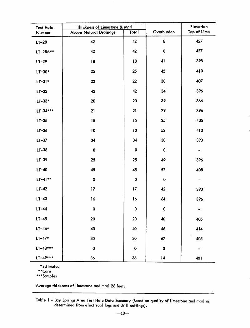
Test Hole Thickness of Limestone & MarlOverburden
Elevation
Number Above Natural Drainage Total Top of Lime
LT-28 42 42 8 427
LT-28A** 42 42 8 427
LT-29 18 18 41 398
LT-30* 25 25 45 410
LT-31* 22 22 38 407
LT-32 42 42 34 396
LT-33* 20 20 39 366
LT-34*** 21 21 29 396
LT-35 15 15 25 405
LT-36 10 10 52 413
LT-37 34 34 38 393
LT-38 0 0 0 -
LT-39 25 25 49 396
LT-40 45 45 52 408
LT-41** 0 0 0 -
LT-42 17 17 42 393
LT-43 16 16 64 396
LT-44 0 0 0 -
LT-45 20 20 40 405
LT-46* 40 40 46 414
LT-47* 30 30 67 405
LT-48*** 0 0 0 -
LT-49*** 36 36 14 401
* Estimated
**Core
***Samples
Average thickness of limestone and marl 26 feet.
Table 1 - Bay Springs Area Test Hole Data Summary (Based on quality of limestone and marl asdetermined from electrical logs and drill cuttings).
—10—

Calculation Area No.
2
3
4
5
6
7
Location
Sec. 17 cS 18, T. 2 N., R. 10 E.
Sec. 17, T. 2 N., R. 10 E.
Sec. 17, T. 2 N., R. 10 E.
Sec. 17, T. 2 N., R. 10 E.
Sec. 17, T. 2 N., R. 10 E.
Sec. 18, 19&20, T. 2 N., R. 10 E.
Sec. 18 & 19, T. 2N., R. 10 E.
Total
Cubic Yards
2,233,583
1,811,319
481,537
1,422,388
4,018,986
983,446
3,589,301
14,540,560
Table 2 - Estimated Volume of Limestone and Marl in Vicksburg Group (Bay Springs Area).
Calculation Area No. Location Cubic Yards
1 Sec. 18 & 19, T. 2 N., R. 10 E. 1,377,851
2 Sec. 17, T. 2 N., R. 10 E. 561,137
3 Sec. 17, T. 2 N., R. 10 E. 224,086
4 Sec. \7r T. 2 N., R. 10 E. 1,940,893
5 Sec. 17, T. 2 N., R. 10 E. 4,457,868
6 Sec. 18, 19&20, T. 2 N., R. 10 E. 851,901
7 Sec. 18 & 19, T. 2 N., R. 10 E. 2,776,180
Total 12,189,916
Table 3 - Estimated Volume of Overburden (Bay Springs Area).
—11—

R.
9E
.R
.10
E.
!28
Fig
ure
4-
Top
ogra
phic
Map
.
BA
YS
PR
IN
GS
AR
EA
0I
MILE
SC
AL
E
BA
YS
PR
IN
GS
1.5
Ml.
LA
UR
EL
24
Ml.

f
E-l
ogof
Tes
tH
ole
LT-4
0C
ata
ho
ula
Fo
rmati
on
or
Yo
un
ger
Ter
race
Bu
catu
nn
aF
orm
ati
on
Gle
nd
on
Fo
rmat
ion
Mari
an
na
Fo
rmati
on
Min
tS
pri
ng
Fo
rmat
ion
(San
dF
acie
s)
Fo
rest
Hill
Fo
rmati
on
SC
AL
E
BA
YS
PR
IN
GS
AR
EA
LE
GE
ND
LT
-39
Tes
th
ole
nu
mb
er
+39
6'D
atum
top
ofli
mes
tone
(Abo
vese
ale
vel)
Proj
ecte
dlim
esto
nesu
bcro
pC
on
tou
rin
terv
al=
10fe
et
Fig
ure
5-
Pro
ject
edSu
bcro
pan
dIs
opac
hof
Vic
ksbu
rgL
imes
tone
and
Mar
l.
Buf
ferz
one
boun
dary
Pav
ed
road
Gra
vel
road
Rail
road
*N
OT
E:
No
lim
esto
nein
test
ho
le♦♦Total
thic
knes
sno
tpen
etra
ted
(los
tcir
cula
tion)

I— r
Figu
re6
-Pr
ojec
ted
Out
crop
ofV
icks
burg
Lim
esto
nean
dM
arl
and
Isop
ach
ofO
verl
ying
Mat
eria
l.

r
Figu
re7
-C
alcu
latio
nA
reas
for
Vol
ume
ofLi
mes
tone
and
Mar
l(C
alcu
latio
nsba
sed
onE
stim
ates
ofA
vail
abil
ity,
Qua
lity
,E
leva
tion
Abo
veN
atur
alD
rain
age,
and
Lim
esto
neto
Ove
rbur
den
Rat
io).

Test Hole
Number
LT-10
LT-11
LT-12
LT-13*
LT-14*
LT-15*
LT-16
LT-17
LT-18
LT-19**
LT-20
LT-21
LT-22
LT-23
LT-24
LT-25*
LT-26*
LT-27*
*Estimated
**Core
Thickness of Limestone & Marl
Above Natural Drainage
20
40
47
24
27
60
0
20
47
0
0
10
0
0
30
20
25
Total
60
60
45
50
50
50
62
0
60
52
60
56
60
59
60
60
60
60
Average thickness Glendon 25 ft, Marianna 30 ft*
Overburden
77
56
0
3
36
38
2
0
35
2
111
23
57
72
64
9
15
20
Elevation
Top of Lime
263
374
375
387
354
357
389
360
393
329
332
358
348
346
366
350
365
Table 4 - Heidelberg Area Test Hole Data Summary (Based on Quality of Limestone and Marl as Determinedfrom Electrical Logs and Drill Cuttings).
—16-

Calculation Area No.
1
2
3
3a
3b
4
4a
Location
Sec. 2&3, T. ION., R. 10 W.
Sec. 2, T. ION., R. 10 W.
Sec. 2, T. 10 N., R. 10 W.
Sec. 2, T. ION., R. 10 W.
Sec. 2, T. 10 N., R. 10 W.
Sec. 1, T. 10 N., R. 10 W.
Sec. 1, T. 10 N., R. 10 W.
Total
Cubic Yards
4,769,323
538,744
2,718,778
346,337
185,162
1,148,282
2,527,879
12,150,310
Table 5 - Estimated Volume of Limestone and Marl in Vicksburg Group (Heidelberg Area).
Calculation Area No. Location Cubic Yards
1 Sec. 2, T. ION., R. 10W. 379,673
2 Sec. 2, T. 10 N., R. 10W. 177,797
3 Sec. 2, T. 10 N., R. 10W. 5,291,361
3a Sec. 2, T. 10 N., R. 10W. 29,629
3b Sec. 2, T. ION., R. 10W. 170,388
4 Sec. 1, T. ION., R. 10W. 1,965,102
4a Sec. 1, T. 10 N., R. 10W. 4,263,390
Total 12,277,340
Table 6 - Estimated Volume of Overburden (Heidelberg Area)
—17-

89°0
0^|3
1100
0mt
Fig
ure
8-
Top
ogra
phic
Map
of
Hei
delb
erg
Are
a.
BA
YS
PR
ING
S2
2M
l.v
ME
RID
IAN
41M
l.H
EID
EL
BE
RG
1.3
Ml.
\ST
AF
FO
RD
SPR
ING
S2.
8M
l.

—19—
CNCN
_0O
X
<DI—
o
_o
LU
o
oc
o
c
&p
O-
c
_o
E o c .2 Eo
Lt_fc
u oli.
C3
co
C Oc "-o
X
I-
CO
1/
5
4^
u_
:&M
o-Q
<D O0
<3 C
cq a. 6 £
LlI
a:1 1 .
< |
1
|
Oa:UJ UJ
m0UJ
_iUJ
Qa
S -M^H u 15
UJa> -o J!
I
enumber topoflimest< ovesealeve edlimestone rinterval=
_c f
TestDati
(
Proi
1-
O
U
c^^^
5
a> u,
J:*
li* *
*

—20—

Fig
ure
11-
Cal
cula
tion
Are
asfo
rV
olum
eof
Lim
esto
nean
dM
arl
(Cal
cula
tion
sba
sed
onE
stim
ates
ofA
vai
lab
ilit
y,
Qu
alit
y,
Ele
vati
onab
ove
Nat
ura
lD
rain
age,
and
Lim
esto
neto
Ove
rbur
den
Rat
io).

WAYNESBORO AREA
The site is located two to three and one-half milesnorth of the town of Waynesboro. Included in the areaare parts of Sections 23, 24, 25 and 26, Township 9North, Range 7 West. Highway 45 adjoins the areaon the east and the Illinois Central Gulf Railroadforms the western boundary of the area. More than750 acres are included in the tract All acreage isbeing utilized as timberland.
The Waynesboro site was divided into 8 subdivisions for calculation purposes. Since this site isessentially one continuous tract of land the individualsubdivisions were not discussedseparately as were thesubdivisions in the Bay Springs and Heidelberg areas.
Ten test holes drilled in the Waynesboro area allencountered limestone and marl of the VicksburgGroup at elevations high enough to be mined. Datafrom the test holes show the limestones and marlsattain their greatest thickness at or near the surfacein this area. Maximum thickness is 80 feet. The sectionincludes the Glendon Limestone and the underlyingMarianna Limestone. In test hole numbers LT-3, 6*8, 9 and AM-32 (May 1974) Bucatunna Clay overliesthe Glendon Limestone as part of the overburden.Average thickness of the Bucatunna Clay is 20 feet.
At the localities of the remainder of the test holesoverburden consists of terrace material from 0 to33 feet thick.
Limestone and marl of the Chickasawhay andPaynes Hammock Formations were encounteredoverlying the Bucatunna Clay in test hole numbersLT-3, 6, 8, 9 and AM-32. This limestone and marlsection is from 20 to 35 feet thick in these testholes. The Chickasawhay Formation has been calculated to underlie approximately 500 acres in thesouthern part of the area. The Waynesboro area isthe only site where the Chickasawhay and PaynesHammock Formations are significantly developed.
The Glendon consists of crystalline, fossiliferous,hard limestone ledges with soft interbeds. TheMarianna Limestone is soft, fossiliferous, chalky,and more homogeneous than the Glendon. Limestoneand marl of the Chickasawhay and Paynes HammockFormations are similar in composition to materials inthe Glendon. Chemical analyses show the calciumcarbonate content of the materials in the GlendonFormation to be slightly higher than that in the strataof the Marianna Formation. At or near the surfacethe upper part of the formations at some localitieshas been weathered and if so, the calcium carbonatemay be less due to leaching.
—22—

Tes
tH
ole
Nu
mb
er
Th
ickn
ess
of
Lim
esto
ne
&M
arl
Overb
urd
en
Ele
va
tio
n
Ab
ove
Nat
ural
Dra
inag
eT
ota
lC
hick
asaw
hay
Top
of
Lim
e(V
icks
burg
)
LT
-14
36
62
22
13
LT
-2*
30
54
19
19
6
LT
-36
57
83
55
71
88
LT
-4*
*5
06
40
23
0
LT
-54
55
82
41
91
LT
-66
08
02
22
22
05
r
11
-7*
37
51
33
21
7
LT
-85
67
82
23
42
06
LT
-94
47
02
06
41
84
AM
-16
30
30
70
18
8
AM
-32
30
68
20
60
16
7
*E
stim
ate
d
**
Co
re
Not
e:C
hick
asaw
hay-
Pay
nes
Ham
moc
kin
terv
alno
tin
clud
edin
over
burd
enfi
gure
s.
Ave
rage
thic
knes
sG
lend
on30
ft.
Mar
iann
a50
ft.
Tabl
e7
-Way
nesb
oro
Are
aTe
stH
ole
Dat
aSu
mm
ary
(Bas
edon
Qua
lity
ofLi
mes
tone
and
Mar
las
Det
erm
ined
from
Ele
ctri
cal
Log
san
dD
rill
Cut
ting
s).

Calculation Area No. Location Cubic Yards
1 Sec. 24, T.9N., R. 7 W. 5,148,749
2 Sec. 24, T. 9N., R. 7 W. 3,292,976
3 Sec. 23, T. 9N., R. 7W. 4,774,632
4 Sec. 23, T. 9N., R. 7 W. 1,633,521
Sec. 26, T. 9N., R. 7 W.
Sec. 25, T. 9N., R. 7 W.
Sec. 25, T. 9N., R. 7 W.
Sec. 26, T. 9N., R. 7 W.
Total
Table 8 - Estimated Volume of Limestone and-Marl in Vicksburg Group (Waynesboro Area).
1,666,861
8,845,477
3,509,669
1,972,451
30,844,336
Calculation Area No. Location Cubic Yards
1
2
Sec. 24&25, T. 9N., R. 7 W.
Sec. 25&26, T. 9 N., R. 7 W.
1,724,274
4,607,945
Total 6,332,219
Table 9 - Estimated Volume of Limestone and Marl in the Chickasawhay - Paynes Hammock Formations(Waynesboro Area).
—24r-

Figure 14 - Projected Outcrop of Limestone and Marl Nearest to the Surface and Isopach of Overlying Material
—28—

Figure 13 - Projected Subcrop and Isopach of Vicksburg Limestone and Marl.
—27—

342 40'MERIDIAN U8 MlHIWANNEE 6 Ml
WAYNESBORO AREA
o
i MILE
SCALE
Figure 12 - Topographic Map of Waynesboro Area.
—26—
R. 7 W. 560 000 FEET R. 6 W.

Calculation Area No. Location Cubic Yards
1 Sec. 23, T. 9N., R. 7 W. 1,707,605
2 Sec. 23, T. 9N., R. 7 W. 640,815
3 Sec. 24&25, T. 9 N., R. 7 W. 5,556,204
4 Sec. 25&26, T. 9 N., R. 7 W. 4,333,839
5 Sec. 26, T. 9N., R. 7 W. 185,206
Total 12,423,669
Table 10 - Estimated Volume of Overburden Overlying Vicksburg Group (Waynesboro Area).
Calculation Area No. Location Cubic Yards
1
2
Sec. 24&25, T. 9 N., R. 7 W.
Sec. 25&26, T. 9 N., R. 7 W.
327,443
4,204,193
Total 4,531,636
Table 11 - Estimated Volume of Overburden Overlying Paynes Hammock-Chickasawhay Formations.(Waynesboro Area)
—25-

WAYNESBORO AREA
LEGEND
LT-8•
+230'
Test hole number
Datum top of Bucatunna(Above sea level)
Clay subcrop
SCALE
Figure 15 - Projected Subcrop and Isopach of Bucatunna Clay.
—29—
•i h
Contour interval = 10 feet
Buffer zone boundaryPaved road
Railroad
* Bucatunna not present

LT-8
+256'
WAYNESBORO AREA
Test hole number
Datum top of Chickasawhay(Above sea level)
Limestone subcrop
LEGEND
SCALE
Contour interval = 10 feet
Buffer zone boundary
Paved road
Railroad
* Chickasawhay not present
Figure 16 - Projected Subcrop and Isopach of Chickasawhay-Paynes Hammock Limestone and Marl.
—30—

Figure 17-Calculation Areas for Volume of Limestone and Marl (Vicksburg)-Calculations based on Estimates ofAvailability, Quality, Elevation above Natural Drainage, and Limestone to Overburden Ratio.
—31—

LT-8
©
WAYNESBORO AREA
LEGEND
Buffer zone boundary
_^___ Paved road
Railroad
Test hole number
Calculation area code number
SCALE
H—t-
j MILE
Figure 18- Calculation Areas for Volume of Limestone and Marl (Chickasawhay)-Calculations based on EstimatesofAvailability, Quality, Limestone to Overburden Ratio, and Elevation above Natural Drainage.
—32—
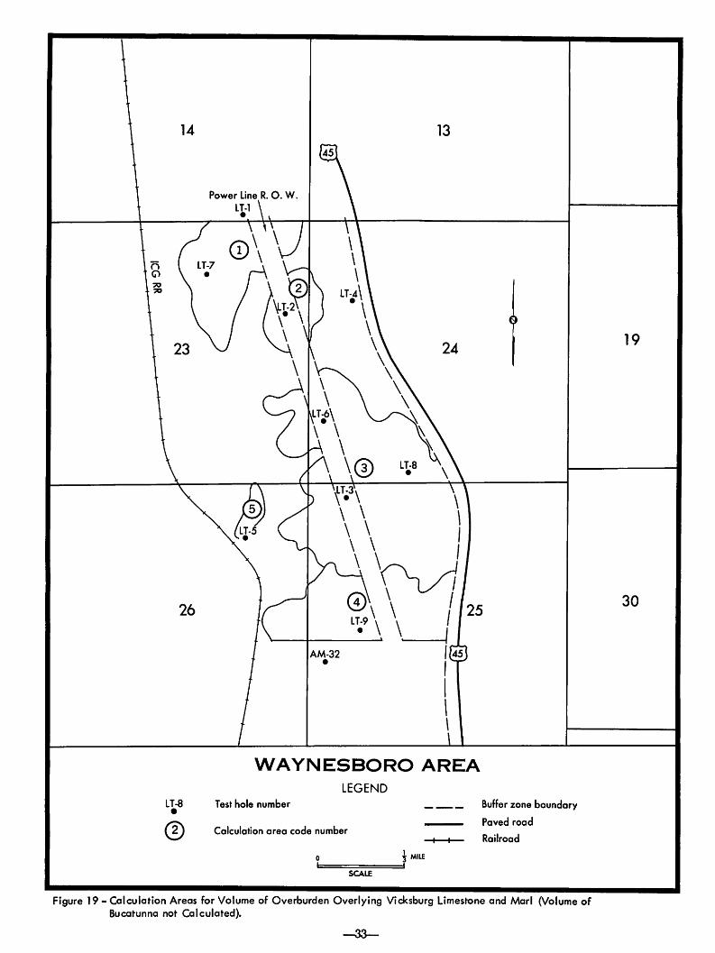
Figure 19 - Calculation Areas for Volume of Overburden Overlying Vicksburg Limestone and Marl (Volume ofBucatunna not Calculated).
—3a—

SUMMARY AND RECOMMENDATIONS
Using guidelines of the Division of Lime, Mississippi Department of Agriculture and Commerce,the Geological Survey investigated three areas aspotential sites for the location of an agricultural limeplant. Guidelines considered were amount of lime-bearing materials available, proximity of rail transportation and acreage acquisition. The nearness ofrail transportation should oe self-explanatory. Acreage acquisition for plant and limestone reserves willbe by lease method with royalty payments to themineral owner. This method is being employed bytie Agriculture Department at their existing limeplants.
Using these guidelines to calculate the volume ofmineable limestone, the area near Heidelberg waseliminated as a prospective site due to present dayland use patterns. Much of the area is adjacent toroadways which would need to be protected by abuffer zone and is also the site of a number of residences which must be considered. In addition the lowlimestone volume to overburden ratio, the total limestonereserve, and added transportation costs involvedwith changing railroads were other factors in thedecision to eliminate tie Heidelberg areafrom furtherconsideration. The total volume of limestone and marlin the Heidelbergarea was calculatedto be 12,150,310cubicyards. Overburden was calculated as 12,277,340cubic yards.
The following table shows the comparison ofthe calculated volume of mineable limestone availableat the Bay Springs and Waynesboro sites:
Mineable limestone
Overburden
Total acres to be mined
Bay Springs Waynesboro
14,540,560Cu. Yards
12,189,916Cu. Yards
694
37,176,555Cu. Yards
16,955,305Cu. Yards
766
Comparisonof the chemical analyses by the Mississippi State Chemical Laboratory are as follows:
Footage Interval7'-ll'
Bay Springs AreaGlendon Fm.
CaCOa Percent93.6
13'-21'21'-27'27'-42'
Marianna Fm.79.082.684.0
Footage Interval0-28'
Waynesboro AreaGlendon Fm.
CaCOa Percent95.0
28'-32'32'-46'46'-62'
Marianna Fm.93.088.062.5
Examination of test hole data shows the sectionof limestone and marl to be more consistent in thickness and more homogeneous in the Waynesboro Areathan in the Bay Springs Area. Average thickness ofmineable material in the Bay Springs Area is 26 feet,whereas at Waynesboro the average thickness is 46feet. This thickness somewhat reflects geologic conditions existing at the sites. At the Bay Springs locality the thin sections of limestone and marl are in partthe result of erosion. In many areas the upper partof the limestone has been eroded and replaced bysand and/or clay. The less desirable lower part ofthe section is all that remains in'many localities. Thisinconsistency is well illustrated by data from testhole numbers LT-29, 35, 36, 39, 41, 42, 43, 44, 45and 48. Test holes LT-41, 44 and 48 are examplesof extreme erosional conditions that may beencountered. In these test holes the limestone hasbeen completely replaced by clay and/or sand. Testhole LT-41 was located less than 100 yards from testhole LT-28 which has a section of limestone and marl42 feet thick. Tnis illustrates the abruptness withwhich the section varies in the Bay Springs area.Much of the Bay Springs Area was inaccessible tothe field party for drilling test holes because of thenature ot the terrain and the forested conditions.Therefore, due to the known extreme erosional conditions existing in the area, the investigators feelthat it is possible that other areas included in thecalculations of the Bay Springs prospect may alsobe severely eroded. These conditions were notencountered in the area investigated near Waynesboro. Erosion encountered in this area was at thesurface in the updip area of the outcrop. This erosionand leaching involved only the upper few feet anddoes not include all of the upper section. TheGlendon or upper part of the limestone is present inall test holes drilled in the Waynesboro site.
Comparison of the calcium carbonate content ofthe materials involved shows the percent of calciumcarbonate of the limestone to be greater in theWaynesboro Area than at Bay Springs. At Waynesboro the procedure of mining only that materialabove natural drainage will dictate that in most ofthe area only the upper part of the limestone willbe mined. Chemical analyses show the upper partof the limestone at Waynesboro to contain 90 to 95percent calcium carbonate. In the Bay Springs areaall of the limestone section is above natural drainageand the entire section was included in the calculationof the volume of limestone. As much of the uppersection at the Bay Springs site has been removed,only the lower section that contains a lower percentage of calcium carbonate remains. Analysis ofthe lower section shows the calcium carbonate tobe in the low 80 percent zone and below.
Physical comparison of the two sites shows thefollowing: At Waynesboro the limestone reservesare in one tract, adjacent to the railroad and U. S.Highway 45. Sufficient frontage and acreage for a5,000 foot railroad spur is available on the site.Preparation of the road-bed for a rail spur would beat tie lowest possible cost as terrain adjacent to theexisting rail line is nearly flat. Access from Highway
—34—

45 to potential crusher and loading location would beaccomplished with a roadway approximately three-quarters of a mile in length. An existing county roadof approximately half this length adjoins the tractto the north. All mining operations would be conducted on the site without disruption of publicvehicle traffic. The quarry floor will be limestone,allowing operations in more inclement weather.Quality control of mined limestone should be at aminimum. The electrical power line traversing thearea from north to south should pose no problemsto transportation during mining operations as theSurvey drilling rig crossed under the power line atfour different locations. Overburden to limestoneratio is approximately 1 to 2 over the entire area.However, during the early years of the plant lifeoperating in the north end of the tract this ratio shouldbe approximately 1 to 4, as there should be approximately 10 million cubic yards of available limestonecompared to 2% million cubic yards of overburden.Overburden will increase as mining operations progress to the south. If the area south of LimestoneCreek were deleted the limestone reserves would bedecreased by approximately 10,090,065 cubic yardsand the overburden would be decreased by approximately 10,638,278 cubic yards. Calculations of limestone were conservative in regard to mining to depthsabove natural drainage and it is possible that the limestone reserve calculation could be greater. However,the thickness of limestone is sufficient for miningoperations below natural drainage should this typeof mining be contemplated.
At Bay Springs the limestone reserves are inseven scattered tracts, two of which adjoin Highway15, neither of which would be centrally located formining operations. None of the tracts adjoin the railroad and none are of sufficient length to accommodate a rail spur of 3,000 feet (recommended lengthof rail spur, personal communication TransportationBranch, Research and Development Center). A railspur to any of the tracts would necessitate a crossingof Highway 15, and at least one county road, wouldinvolve property owners not included in the reservetract, and be more costly due to road bed preparationbecause of terrain irregularities. Overburden immediately becomes a problem in mining operations.This problem is more acute in the Bay Springs areadue to the more deeply dissected terrain. The overalloverburden to limestone ratio is approximately 1to 1 with 12,189,916 cubic yards of overburden to14,540,560 cubic yards of limestone. The scatteredtracts will necessitate additional cost of hauling limestone from quarry to crusher site. Experience of theAgriculture Department shows this cost to be from14.8 to 16.8 cents per ton for a three mile and twomile haul, respectively. The three mile haul is by10 ton truck and the two mile haul is by 5 ton truck.With a crusher site centrally located, these mileagefigures would be appropriate for approximately three-fourths of the limestone mined. Much of this haulingcould be accomplished on existing county roads. Suchtraffic would be a detriment to maintenance of these
roads and would cause an additional traffic hazardin areas of rural residences. The varied depositionalconditions encountered would pose a problem inquality control. In some instances the quarry floorwould consist of clay which could delay quarry operations for a longer period of time during or after inclement weather.
Transportation data of crushed limestone shippedfrom State-operated lime plants for the period July 1,1973 to June 30, 1974, shows that where rail transportation was available at the Macon plant, 26,325tons were shipped by rail and 52,564 tons by truck.An additional 119,954 tons were shipped by truckfrom the" West Point plant. For this period 15 percent of the shipped limestone was by rail. Oral communications with the Department of Agriculture indicate that a large percentage of the limestone truckedfrom the West Point plant was to "Delta" destinations.
It should be noted that some areas of limestonereserves were deleted in the Bay Springs area. Thesebuffer zones were omitted due to existing land usepatterns. To acquire acreage under existing pavedcount)' roads, a State Highway, residences and otherrural buildings would be prohibitive in cost. Underthe Department of Agriculture proposed acreageacquisition of lease by royalty payment, these properties could not be acquired. The Department willexperience enough difficulty in attempting to leaseimproved pasture land and land adjoining rural residences. There will be some twenty-six different landowners to negotiate leases with on the investigatedtracts, some of whom may not agree with the Department of Agriculture payment of royalty for lease acquisition. Communication from the Department ofAgriculture indicates that eminent domain proceedingswill not be used to secure acreage for a plant location.If such proceedings were to become a reality, a fairmarket value for lands involved would be in order.Such land that was deleted from the Bay Springs areawould command an enormous price if they were included. This would add to the cost factor of crushedlimestone.
It was the recommendation of the writers basedon factors of mineable limestone reserve, thicknessof limestone, continuity of limestone, quality of limestone, overburden to limestone ratio, total overburden,compactness of proposed area, less cost of providingaccessibility to transportation, less hazardous and uninterrupted mining operations, shorter hauls fromquarry to crusher, present land use patterns, and lesspotential damage by environmental pollutants suchas noise and dust, that the Waynesboro Area shouldbe selected as the site for the proposed AgriculturalLimestone Plant.
The recommendation of the writers was acceptedand a 200-ton-per-hour capacity plant is presently inoperation at the Waynesboro Site.
All original test hole cuttings, cores, field notes,electrical logs, and maps are available for observation at the Geological Survey.

REFERENCES CITED
Baughman, Wilbur T., 1971, Rankin County Geologyand Mineral Resources: Miss. Geol. Survey Bull.115, p. 41-53.
Bouchard, Harry, 1965, Surveying, Fifth edition: International Textbook Company, p. 520-555.
DeVries, David A., 1963, Jasper County Mineral Resources: Miss. Geol. Survey Bull. 95, p. 32-44.
Luper, Edwin E., 1972, Smith County Geology andMineral Resources: Miss. Geol. Survey Bull. 116,p. 33-44.
MacNeil, F. Stearns, 1944, Oligocene Stratigraphy ofSoutheastern U.S.: Amer. Assoc, of Pet. Geol.Bull., Vol. 28, p. 1313-1354.
May, James H., 1974, Wayne County Geology andMineral Resources: Miss. Geol. Survey Bull. 117,p. 64-107.
Mellen, Frederic F., 1940, Yazoo County Mineral Resources: Miss. Geol. Survey Bull. 39, p. 23-28.
Mellen, Frederic F., 1941, Warren County MineralResources: Miss. Geol. Survey Bull. 43, p. 19-43.
Mellen, Frederic F„ 1942, Mississippi AgriculturalLimestone: Miss. Geol. Survey Bull. 46, 20 pp.
Mississippi Geological Society, 1948, Upper Eocene,Oligocene and lower Miocene of central Mississippi: Sixth Field Trip Guidebook, 74 pp.
Moore, William H., 1965, Hinds County Geology andMineral Resources: Miss. Geol. Survey Bull. 105,p. 65-108.
Rooney, Lawrence F., and Carr, Donald D., 1971,Applied Geology of Limestone and Dolomite:Indiana Geol. Survey Bull. 46, 59 pp.
Toler, Henry N., 1964, Raw Material and FeasibilityStudy tor Cement Plant, Smith County, Mississippi: Area Redevelopment Administration, Contract Cc-6020, pt. 1, various pages.
—36—

TEST HOLE AND CORE HOLE DATA
The following are descriptions of cuttings and cores from test holes drilled and/or cored during thegeologic study of potential agricultural lime producing sites in Jasper and Wayne Counties, Mississippi. Allthe described samples are cataloged and stored in the Survey's Sample Library, where they are available forpublic observation. The samples were washed prior to microscopic examination.
The test hole locations and elevations were determined from 7.5 minute topographic maps.
All thicknesses and depths are expressed in feet.
SAMPLE DESCRIPTIONS
WAYNE COUNTY
LT-1
Location: SE/4, SE/4, SW/4, SE/4, Sec. 14, T.9N., R.7W. Elevation: 235 feet
FootageInterval Description
0-15 Clay, red, yellowish to gray, silty, bentonitic appearance.15-22 Marl, light gray to grayish yellow, fossiliferous, clayey, (residuum?)22-40 Limestone, white to yellow, crystalline, fossiliferous, glauconitic, weathered.40-50 Limestone, light gray, crystalline, fossiliferous, glauconitic, argillaceous inclusions.50-62 Limestone, white to light gray, fossiliferous, finely glauconitic, slightly chalky, with thin marl beds.62-74 Marl, light gray, very glauconitic, fossiliferous, pyritic with some indurated ledges.74-76 Clay, medium gray, slightly carbonaceous.76-90 Marl, light gray, fossiliferous, glauconitic, hard ledges.
LT-2
Location: NW/4, SE/4, SE/4, NE/4, Sec. 23, T.9N., R.7W. Elevation: 218 feet
FootageInterval
0-1010-20
Description
Clay, tan to red, bentonitic appearance.Clay, light to dark brown, slightly calcareous with limestone nodules and fossils (residuum).Note: Lost circulation.
LT-3
Location: NW/4, NE/4, NW/4, NW/4, Sec. 25, T.9N., R.7W. Elevation: 280 feet
FootageInterval Description
0-28 Sand, clear, medium to coarse, round to subangular, poorly sorted, frosted and ferruginous stain,becoming more fine-grained in bottom 10 feet.
28-43 Marl, medium gray, fossiliferous, glauconitic, clayey.43-52 Marl, medium gray, fossiliferous, glauconitic, sandy.52-59 Marl, medium gray, fossiliferous, glauconitic, argillaceous.59-75 Limestone, yellow to light gray, fossiliferous, glauconitic, hard; interbeddedwith marl, gray, fossili
ferous, glauconitic sandy.75-90 Clay, gray, silty, carbonaceous, glauconitic.90-120 Limestone, white to yellow, fossiliferous, glauconitic, interbedded with marl.
120-130 Limestone, light to medium gray, fossiliferous, glauconitic.130-168 Limestone, white to light gray, slightly fossiUferous, finely glauconitic, slightly chalky, with
some thin marl beds. Limestone softer than limestone 120-130.168-176 Marl, light gray, fossiliferous, glauconitic, sandy.176-182 Marl, gray, fossiliferous, glauconitic, clayey.182-185 Sand, clear, fossiliferous, glauconitic.185-190 Silt, gray, carbonaceous.
—37—

LT-4 (CORE)
Location: SW/4, NE/4, SW/4, NW/4, Sec. 24, T.9N., R.7W. Elevation: 228 feet
FootageInterval Description
0-18 Limestone, light yellowish gray, fossiliferous, some red weathered material 12 to 13 feet.18-32 Limestone, light yellowish gray, fossiliferous, hard, soft streaks at 26 to 28 feet and 31 to 32 feet.32-42 Marl, yellowish gray to greenish gray, fossiliferous, partially indurated.42-48 Marl, yellowish gray to greenish gray, fossiliferous, softer than above.48-62 Marl, light greenish gray, fossiliferous, glauconitic, partially indurated.62-64 Marl, dark gray, fossiliferous, glauconitic; claystone nodules at 63 feet; some fossiliferous sand in
bottom foot.64-67 Sand, dark gray, micaceous.
LT-5
Location: SW/4, SW/4, NE/4, NE/4, Sec. 26, T.9N., R.7W. Elevation: 215 feet
FootageInterval Description
0-2 Silt, light gray, red mottled, sandy.2-8 Sand, clear, fine to coarse-grained, round to subangular, poorly sorted, frosted and ferruginous
stain, fossil fragments and limestone nodules.8-20 Clay, light gray, red mottled, slightly silty to silty.
20-24 Clay, reddish brown, lime nodules (residuum).24-34 Limestone, light gray, fossiliferous, crystalline, slightly glauconitic, weathered.34-70 Limestone, light gray, fossiliferous, finely pyritic, slightly chalky, slightly glauconitic; some thin
marl beds.70-78 Clay, medium gray, slightly sandy, slightly fossiliferous.78-90 Marl, light to medium gray, sandy, fossiliferous, glauconitic, clayey, indurated ledge 80 and 89
feet.90-110 Clay, medium gray, silty, slightly sandy, finely micaceous, carbonaceous, slightly fossiliferous.
LT-6
Location: NE/4, NW/4, SW/4, SW/4, Sec. 24, T.9N, R.7W. Elevation: 255 feet
FootageInterval Description
0-4 Clay, reddish brown, slightly glauconitic, slightly fossiliferous, (residuum).4-12 Limestone, light gray to yellowish gray, fossiliferous, glauconitic, slightly sandy, weathered.
12-26 Marl, light to yellowish gray, red stain, fossiliferous, silty, clayey, slightly sandy.26-42 Clay, gray, silty, slightly carbonaceous, slightly calcareous, slightly fossiliferous.42-76 Limestone, tan to reddish tan, crystalline, fossiliferous, slightly sandy, weathered, very porous,
reddish color probably due to oxidation.76-110 Limestone, white to light gray, fossiliferous, finely glauconitic, chalky appearance, soft, becoming
marly 100 to 110 feet.110-126 Marl, light gray, fossiliferous, glauconitic, sandy, in part indurated.126-140 Marl, light gray, fossiliferous, glauconitic, very sandy.
LT-7
Location: SE/4, SW/4, NW/4, NE/4, Sec. 23, T.9N., R.7W. Elevation: 255 feet
FootageInterval Description
0-12 Sand, clear to tan, medium-to coarse-grained, some glauconite, limenodules, streakof brown siltyclay.
12-20 Clay, light gray to brown, silty, sandy.20-33 Clay, light brownish gray, slightly silty, fossil fragments.33-40 Limestone, yellowish tan, fossiliferous, very porous.
—38—

LT-8
Location: SW/4, SE/4, SE/4, SW/4, Sec. 24, T.9N., R.7W. Elevation: 290 feet
FootageInterval Description
0-24 Sand, reddish orange, medium-to coarse-grained, rounded to subangular, silty.24-28 Clay, light gray, slightly sandy.28-34 Sand, clear to yellow, fine-to medium-grained, rounded to subangular.34-46 Marl, light gray, fossiliferous, glauconitic, slightly sandy, in part indurated.46-60 Marl, light gray, fossiliferous, slightly glauconitic, clayey, in part indurated.60-84 Clay, gray, silty, fossiliferous, carbonaceous, becoming marly in bottom 2 feet.84-88 Limestone, gray, fossiliferous.88-106 Marl, grayish brown, fossiliferous, sandy, in part indurated.
106-110 Limestone, light gray, fossiliferous, glauconitic.110-160 Limestone, light gray, fossiliferous, glauconitic, chalky, marly, becoming sandy at 140 to 150 feet.160-170 Marl, light gray to gray, fossiliferous, glauconitic, sandy, with thin clay streaks.
LT-9
Location: SE/4, NE/4, NW/4, SW/4, Sec. 25, T.9N., R.7W. Elevation: 280 feet.
FootageInterval Description
0-24 Sand, dark yellowish orange, fine-to very coarse-grained, rounded to subangular quartz, ferruginous, light yellowish gray clay from 15'-18', rare black grains.
24-33 Clay, weathered reddish brown at top then greenish gray, glauconitic, calcareous.33-39 Marl, light yellowish gray, fossiliferous (ostracodes and foraminifers), calcareous.39-45 Marl, dark gray, very argillaceous, slightly calcareous.45-55 Limestone, fight yellowish gray, fossiliferous, arenaceous, marl streaks.55-95 Clay, light olive gray, silty to sandy, calcareous, carbonaceous, micaceous, fossiliferous.95-97 Marl, olive gray, very fossiliferous, foraminifera and fossil fragments.97-130 Limestone, light olive gray, hard ledges with some softer marl streaks, very fossiliferous.
130-150 Marl, light yellowish gray, fossiliferous (abundant Lepidocyclina), ledges in the 140-150 foot interval.
150-165 Marl, light olive gray, arenaceous (quartz and glauconite), fossiliferous.165-170 Clay, dark gray, silty, carbonaceous.170-174 Marl, light olive gray, very fossiliferous, arenaceous.174-180 Clay, dark gray, silty, carbonaceous, sparingly fossiliferous.
JASPER COUNTY
LT-10
Location: SW/4, NW/4, NW/4, NE/4, Sec. 10, T.10N., R.10W. Elevation: 340 feet
FootageInterval Description
0-10 Sand, grayish, yellow to reddish brown, argillaceous, ferruginous.10-19 Clay, light olive gray (weathered reddish brown near top), glauconitic.19-44 Clay, dark gray, silty, carbonaceous, micaceous.44-64 Marl, light gray, very arenaceous (medium-grained subangular quartz), fossiliferous, echinoid spine
noted, rare dark grains, hard streaks.64-71 Clay, dark gray, silty, carbonaceous, slightly calcareous.71-77 Marl, light olive gray, fossiliferous (abundant foraminifers).77-81 Limestone, light olive gray, smooth-textured, hard, fossiliferous.81-90 Marl, olive gray, fossiliferous, argillaceous.90-103 Limestone, light olive gray, fossiliferous, hard ledges, softer marl streaks, pyritic.
103-130 Marl, very light gray, soft, argillaceous, fossiliferous, some harder streaks.130-139 Marl, very light gray, fossiliferous, arenaceous.139-160 Clay, dark gray, silty, carbonaceous, pyritic, slightlycalcareous, arenaceous in lower part.
—39—

LT-11
Location: SE/4, NW/4, NW/4 (Irregular Section), Sec. 1, T.10N., R.10W. Elevation: 430 feet
FootageInterval
0-18
18-2525-2929-5050-5656-5959-7171-8787-115
115-120120-140
Description
Sand, light brown, medium-to coarse-grained, angular to subangular quartz, scattered black grains,ferruginous, light red clay streaks.Clay, dark gray, silty.Sand, medium gray, subangular, quartz, medium-to coarse-grained.Clay, dark gray, silty, micaceous, carbonaceous, white precipitate on clayparticles.Marl, light gray, very fossiliferous (abundant foraminifers).Limestone, light gray, hard, fossiliferous.Marl, dark gray, argillaceous neat top and becoming more fossiliferous in lower part.Limestone, yellowish gray, hard ledges, fossiliferous, softer interbedded marl.Marl, very light gray, fossiliferous (abundant Lepidocyclina).Marl, very light gray, glauconitic.Clay, dark gray, silty, carbonaceous, fossiliferous, sandy in lower part.
LT-12
Location: SW/4, NE/4, NW/4 (Irregular Section), Sec. 2, T.10N., R.10W. Elevation: 375 feet
FootageInterval
0-1212-3838-4545-60
Description
Limestone, light brown (weathered), hard ledges, abundant Lepidocylina.Marl, yellowish gray, fossiliferous, argillaceous, bryozoa noted.Marl, medium gray, fossiliferous, glauconitic.Clay, dark gray, silty, carbonaceous, arenaceous in lower part.
LT-13
Location: NW/4, SW/4, NW/4 (Irregular Section), Sec. 2, T.10N., R.10W. Elevation: 395 feet
FootageInterval
0-10
Description
Clay, reddish brown, fossiliferous, weathered limestone at 6 feet, (lost circulation)
LT-14
Location: SE/4, SW/4, NW/4 (Irregular Section), Sec. 2, T.10N., R.10W. Elevation: 395 feet
FootageInterval
0-22-30
30-3535-40
Description
Sand, reddish brown, fine-to medium-grained, scattered black grains, ferruginous.Clay, yellowish gray and reddish brown mottled, silty, bentonitic, ferruginous.Clay, dark brown to dark gray, weathered, silty, ferruginous.Limestone, grayish orange, weathered, fossiliferous, badly leached, (lost circulation)
LT-15
Location: NE/4, NW/4, SW/4 (Irregular Section), Sec. 2, T.10N., R.10W. Elevation: 397 feet
FootageInterval
0-4
4-38
Description
Sand, dark yellowish orange, fine-to medium-grained quartz, subangular, ferruginous.Clay, yellowish gray, smooth-textured, bentonitic, ferruginous, (lost circulation in weatheredzone at 38' at contact with limestone.)
LT-16
Location: SW/4, SW/4, NW/4 (Irregular Section), Sec. 2, T.10N., R.10W. Elevation: 395 feet
FootageInterval
0-4.54.5-8
8-20
Description
Clay, light brown, weathered, calcareous.Limestone, yellowish gray, hard, fossiliferous, weathered.Marl, light brown to yellowish gray, fossiliferous, gypsiferous, weathered.
-40-
20-34 Limestone, light brown, weathered, hard ledges with soft marl interbeds, fossiliferous.34-40 Marl, very light gray, argillaceous, fossiliferous.40-55 Marl, light olive gray, argillaceous, fossiliferous, soft, numerous bryozoa.55-67 Marl, greenish gray, glauconitic, fossiliferous.67-80 Clay, dark gray, silty to sandy, carbonaceous, sparingly fossiliferous, fissile.
LT-17
Location: NE/4, NE/4, NE/4 (Irregular Section), Sec. 2, T.10N., R.10W.
FootageInterval Description
0-6 Sand, dark yellowish orange, argillaceous, ferruginous.6-12 Clay, yellowish gray, bentonitic.
12-14 Sand, light brown, subangular quartz and ferruginous weathered material.14-36 Clay, dark gray, silty, pyritic, slightly calcareous, micaceous, fossiliferous.36-50 Silt, dark gray, arenaceous, carbonaceous, slightly calcareous, fossiliferous.50-70 Clay, dark gray, silty, carbonaceous, micaceous, sparingly fossiliferous.
LT-18
Location: SE/4, SE/4, NE/4 (Irregular Section), Sec. 2, T.10N., R.10W.
FootageInterval Description
0-6 Sand, light brown, fine-to medium-grained quartz, ferruginous.6-23 Clay, yellowish gray, bentonitic.
23-30 Clay, dark gray, silty, carbonaceous.30-35 Marl, medium gray, fossiliferous, soft.35-37 Limestone, light gray, smooth-textured, hard, fossiliferous.37-48 Marl, light to dark gray, very fossiliferous, coquina-like.48-60 Limestone, light gray, hard ledges with softer interbeds, fossiliferous.60-97 Marl, very light gray, soft, fossiliferous, argillaceous, more glauconitic last few feet.97-110 (Say, dark gray, silty, carbonaceous, pyritic, slightly calcareous.
LT-19 (CORE)
Location: NW/4, SW/4, NW/4 (Irregular Section), Sec. 2, T.10N., R.10W.
Elevation: 355 feet
Elevation: 395 feet
Elevation: 395 feet
FootageInterval Description
0-3.5 Clay, dark reddish brown, ferruginous, probably residual clay.3.5-6.5 Marl, grayish orange, weathered, very fossiliferous, hard streaks.6.5-9.0 Limestone, grayish yellow, weathered, hard ledges with soft interbeds, fossiliferous.9.0-14 Limestone, yellowish gray, not as badly weathered as above, some hard ledges with soft interbeds.14-15 Marl, light brown, weathered, argillaceous, fossiliferous.15-18 Cavity (no recovery).18-24 Limestone, light yellowish gray, hard ledges, argillaceous, fossiliferous.24-30 Marl, greenish gray (unweathered), argillaceous, hard ledges, fossiliferous.30-42 Marl, greenish gray to very light gray, argillaceous, fossils not as apparent as in material above,
homogeneous.42-51 Marl, greenish gray speckled, glauconitic, fossiliferous, hard ledge at 45-46, daystone pebbles at
51'.51-54 Clay, dark gray, silty, laminated, carbonaceous, slightly calcareous.
LT-20
Location: SE/4, SW/4, SE/4 (Irregular Section), Sec. 2, T.10N., R.10W.
FootageInterval
Elevation: 440 feet
Description
0-20 Sand, yellowish orange, medium-grained, subangular to well-rounded quartz, scattered dark grains.20-63 Sand, very pale orange, fine-to coarse-grained, subangular to well-rounded quartz, some dark
grains, micaceous.63-82 Clay, dark yellowish brown (weathered on top) to dark gray, silty, carbonaceous, glauconitic.
—41—

82-90 Marl, light olive gray, fossiliferous, arenaceous, micaceous.90-106 Clay, dark gray, silty, carbonaceous, fossiliferous in lower part.
106-111 Marl, dark gray, fossiliferous (abundant foraminifera).111-113 Limestone, light gray, fine-textured, fossiliferous.113-125 Marl, dark gray, fossiliferous.125-142 Limestone, light gray, hard ledges with softer interbeds, fossiliferous.142-168 Marl, very light gray, argillaceous, fossiliferous (bryozoa and foraminifera),168-180 Clay, dark gray, silty, carbonaceous, sparingly fossiliferous.
LT-21
Location: NW/4, SE/4, SE/4 (Irregular Section), Sec. 1, T.10N., R.10W. Elevation: 355 feet
FootageInterval Description
0-12 Sand and clay, light gray to light brown m ottled, ferruginous.12-19 Clay, light gray to dark brown (weathered), bentonitic.19-23 Clay, dark gray, silty.23-46 Limestone, fight gray, fine-textured, hard ledges withsoft interbeds, fossiliferous.46-78 Marl, very light gray, fossiliferous (broyozoa and foraminifera), soft, glauconitic in lower part.78-90 Clay, dark gray, silty, carbonaceous, calcareous.
LT-22
Location: NW/4, NW/4, SE/4 (Irregular Section), Sec. 2, T.10N., R.10W.FootageInterval
0-1818-3434-5252-5959-6161-6868-8282-119
119-130
Elevation: 415 feet
Description
Sand, light brown, medium-to coarse-grained, mostly subangular quartz, ferruginous.Clay, weathered light brown and gray mojtled near top, then bluish gray, arenaceous last 4 feet.Clay, dark gray, silty, carbonaceous, calcareous.Marl, dark gray, very fossiliferous (many foraminifera).Limestone, light olive gray, fine-textured, hard, fossiliferous.Marl, dark gray, argillaceous, fossiliferous.Limestone, fight olive gray, hard ledges with softer interbeds, fossiliferous.Marl, very light gray, fossiliferous, glauconitic, some hard streaks.Clay, dark gray, silty to arenaceous, carbonaceous, calcareous.
LT-23
Location: SW/4, NE/4, SE/4 (Irregular Section), Sec. 2, T.10N., R.10W. Elevation: 420 feetFootageInterval Description
0-15 Sand, reddish orange, fine-to medium-grained, mostly subangular quartz, ferruginous, somefossilsand glauconite.
15-24 Sand, yellowish orange, coarse-grained, subangular quartz.24-34 Clay, weathered brown and gray near top and dark gray beneath, silty to arenaceous, carbonaceous.34-40 Marl, yellowish gray, arenaceous, fossiliferous.40-45 Limestone, light gray, arenaceous, fossiliferous, hard ledges.45-66 Clay, dark olive gray, silty, carbonaceous, slightly calcareous.66-72 Marl, dark gray, fossiliferous, silty.72-74 Limestone, fight gray, fine-textured, fossiliferous.74-82 Marl, dark gray, fossiliferous, argillaceous.82-103 Limestone, fight gray, hard ledge with softer interbeds, fossiliferous, pyritic.
103-131 Marl, very light gray, argillaceous, fossiliferous, some hard streaks, many bryozoa and foramini-fera noted, more glauconitic in lower part.
131-150 Clay, dark gray, silty, carbonaceous, slightly calcareous.
LT-24
Location: SW/4, SW/4, SW/4 (Irregular Section), Sec. 1, T.10N., R.10W. Elevation: 410 feetFootageInterval
0-9
9-13
Description
Sand, reddish orange, fine-to coarse-grained, mostly subangular quartz, ferruginous, gravel fromsurface.Clay, multicolored, silty, micaceous, ferruginous.
—42—

13-18 Sand, light brown, medium-grained, subangular quartz, micaceous, ferruginous.18-32 Clay, dark gray, silty, fissile, white predpitate on particles.32-46 Marl, light gray, arenaceous, fossiliferous, hard ledge at 39 feet, very fossiliferous in lower part.46-58 Clay, dark gray, silty, fossiliferous.58-64 Marl, medium gray, fossiliferous (numerous foraminifera).64-69 Limestone, light gray, hard, fossiliferous.69-76 Marl, medium gray, soft, fossiliferous.76-94 Limestone, light gray, hard ledges with soft interbeds, fossiliferous.94-126 Marl, very light gray, soft, argillaceous, fossiliferous, glauconitic in lower part.
126-130 Clay, dark gray, silty, carbonaceous.
LT-25
Location: NW/4, SW/4, NE/4 (Irregular Section), Sec. 2, T.10N., R.10W. Elevation: 375 feet.
FootageInterval Description
0-9 Clay, reddish brown, arenaceous, changing to yellowish gray bentonitic clay.9-20 Limestone, light brown, hard ledge overlying cavity at about 15 feet. Lost circulation in cavity.
LT-26
Location: SW/4, NE/4, SW/4 (Irregular Section), Sec. 2, T.10N., R.10W. Elevation: 365 feet
FootageInterval Description
0-15 Clay,mottled reddish brown to light gray, arenaceous, bentonitic in lower part.15-20 Limestone, light brown, hard, fossiliferous. Lost circulation in cavity at about 20 feet.
LT-27
Location: SW/4, NW/4, NW/4 (Irregular Section), Sec. 1, T.10N., R.10W. Elevation: 385 feet
FootageInterval Description
0-10 Clay, light gray, silty, some ferruginous staining, bentonitic.10-21 Clay, yellowish brown, weathered appearing.21-25 Limestone, reddish brown, weathered, very fossiliferous. Lost circulation in cavity at 25 feet.
LT-28
Location: SE/4, NE/4, NE/4, NW/4, Sec. 17, T.2N., R.10E. Elevation: 435 feet.
FootageInterval Description
0-7 Clay, reddish brown, residual material badly weathered.7-19 Limestone, light brown, weathered, hard ledges, fossiliferous, softer interbeds.
19-30 Marl, light yellowish gray, argillaceous, hard streaks, fossiliferous.30-43 Marl, light greenish gray, fossiliferous, glauconitic.43-52 Marl, greenish gray, very glauconitic, arenaceous, fossiliferous, reddish brown weathered zone in
lower part.52-62 Clay, dark gray, silty, carbonaceous, micaceous, slightly calcareous.62-70 Silt, dark gray, argillaceous, carbonaceous, micaceous, calcareous.
LT-28A (CORE)
Location: SE/4, NE/4, NE/4, NW/4, Sec. 17, T.2N., R.10E. Elevation: 435 feetFootageInterval Description
0-7 Clay, light gray, silty, ferruginous, bentonitic.7-20 Limestone, light brown, weathered, fossiliferous, hard ledges, soft marl interbeds.
20-28 Marl, yellowish gray, argillaceous, hard streaks, fossiliferous.28-43 Marl, greenish gray, argillaceous, glauconitic, hard streaks.43-52.5 Marl, dark greenish gray, arenaceous, glauconitic, fossiliferous.
52.5-56 Clay, dark gray, carbonaceous, silty, slightly calcareous.
—43—

LT-29 |
Location: SW/4, NE/4, NW/4, NE/4, Sec. 18, T.2N., R.10E. Elevation: 440 feet
FootageInterval Description
0-17 Sand, light brown, medium-grained, subangular quartz, ferruginous.17-30 Clay, light brown to dark gray, silty, micaceous, carbonaceous.30-42 Clay, yellowish brown, silty, weathered appearance.42-60 Marl, light yellowish gray, weathered, argillaceous to arenaceous, fossiliferous.60-75 Clay, yellowish brown, silty, calcareous, weathered, bentonitic.75-105 Clay, dark gray, silty to arenaceous, carbonaceous, micaceous.
105-140 Silt, dark gray, arenaceous, carbonaceous, micaceous, carbonized and pyritized wood fragments inthe 120-140 foot interval.
LT-30
Location: SW/4, SE/4, NW/4, NW/4, Sec. 17, T.2N., R.10E. Elevation: 455 feet
FootageInterval
0-24
24-45
Description
Sand, reddish brown, medium-to coarse-grained, poorly sorted, subangular to rounded quartz,ferruginous.Clay, light to yellowish gray, silty, bentonitic appearance, ferruginous.Note: Lost circulation at 45'.
LT-31
Location: NW/4, NE/4, SW/4, NW/4, Sec. 17, T.2N., R.10E. Elevation: 445 feet
FootageInterval
0-1010-2323-3838-41
Description
Sand, reddish brown, medium-to coarse-grained, subangular to rounded quartz.Sand, light brown, medium-grained, subangular to rounded quartz.Clay, light brown to light gray, silty, ferruginous.Limestone, dark yellowish orange, weathered, fossiliferous.Note: Lost circulation in cavity at 41'.
LT-32
Location: SW/4, NW/4, NE/4, NW/4, Sec. 20, T.2N., R.10E. Elevation: 430 feet
FootageInterval Description
0-6 Sand, light brown medium-grained, subangular quartz.6-26 Clay, yellowish gray, silty, bentonitic appearance.
26-34 Marl, dusky yellow, fossiliferous, weathered, abundant foraminifera.34-43 Limestone, light brown, weathered, fossiliferous, hard ledge at 34 and 39 feet.43-67 Marl, grayish yellow, soft, argillaceous, homogeneous, fossiliferous.67-82 Marl, grayish yellow, arenaceous, fossiliferous (numerous bryozoa), becoming very sandy (medium-
grained, subangular quartz), micaceous.82-100 Sand, yellowish gray to dark gray, medium-grained, subangular quartz, clay streaks, carbonaceous in
lower part.
LT-33
Location: SE/4, NE/4, SW/4, SW/4, Sec. 18, T.2N., R.10E.
FootageInterval
0-20
20-40
Description
Sand, light brown, fine-to medium-grained, subangular quartz, ferruginous.Clay, brown and gray mottled, sand streaks, ferruginous, weathered.Note: Lost circulation at 39'.
•44-
Elevation: 405 feet

LT-34
Location: NW/4, SW/4, SE/4, SW/4, Sec. 16, T.2N., R.10E. Elevation: 425 feet
FootageInterval Description
0-10 Sand, light brown, medium-grained, mostly subangular quartz, clay streaks.10-21 Clay, light gray and reddish brown mottled, silty, bentonitic appearance.21-29 Clay, dark yellowish orange, silty, weathered.29-40 Marl, light yellowish gray, fossiliferous, argillaceous, weathered.40-50 Marl, yellowish gray, arenaceous, glauconitic, fossiliferous, weathered.50-60 Sand, medium dark gray, fine-to medium-grained, subangular quartz, micaceous, clay streaks, dark
grains in sand.
LT-35
Location: SW/4, NW/4, SW/4, NW/4, Sec. 16, T.2N., R.10E.
FootageInterval Description
0-3 Sand, light brown, medium-grained, subangular quartz, ferruginous.3-12 Clay, light gray to light brown, silty, weathered.
12-25 Clay, dark gray, silty, carbonaceous, pyritic.25-28 Marl, light yellowish gray, weathered dark brown on top, fossiliferous.28-40 Marl, yellowish gray, very sandy, glauconitic.40-55 Sand, yellowish orange, medium-to coarse-grained, subangular quartz, glauconitic, fossiliferous.55-63 Clay, dark gray, silty to arenaceous, carbonaceous, micaceous.63-90 Sand, yellowish gray speckled, medium-grained, subangular quartz, scattered dark grains, mica
ceous, dark gray clay streaks.
LT-36
Location: NE/4, SW/4, NE/4, SW/4, Sec. 9, T.2N., R.10E.
Elevation: 430 feet
Elevation: 465 feet
FootageInterval Description
0-25 Sand, light brown, medium-to very coarse-grained, subangular quartz, ferruginous, poorly sorted.25-43 Clay, light gray to light brown, smooth-textured.43-48 Marl, dark to light brown, weathered, fossiliferous.48-59 Marl, very light yellowish gray, fossiliferous, hard streaks.59-75 Sand, dark reddish brown, poorly sorted subangular quartz, weathered, fossiliferous, glauconitic.75-100 Sand and clay, light gray to dark brown, medium-grained, subangular, quartz, micaceous, carbona
ceous.
LT-37
Location: SE/4, NE/4, NE/4, NW/4, Sec. 19, T.2N., R.10E. Elevation: 430 feet
FootageInterval
0-1010-2424-3737-7171-7878-9393-100
Location:
FootageInterval
0-1515-2323-3535-5858-70
Description
Sand, reddish brown, medium-to coarse-grained, poorly sorted quartz, ferruginous.Sand, light brown, medium-grained, subangular quartz.Clay, dark gray, silty, carbonaceous, pyritic.Marl, light yellowish gray, fossiliferous, hard ledges, argillaceous.Sand, light yellowish gray, medium-grained, subangular quartz, glauconitic, fossiliferous.Clay, dark gray, silty, carbonaceous, micaceous.Sand, light to dark gray, black grains, carbonaceous, pyritic.
LT-38
SE/4, SE/4, NE/4, SE/4, Sec. 8, T.2N., R.10E. Elevation: 435 feet
Description
Sand, reddish brown, fine-to medium-grained, subangular quartz.Clay, light gray, silty, bentonitic appearance.Clay, dark reddish brown, weathered, sand streak.Sand, medium to dark brown, medium-grained, subangular quartz, glauconitic.Sand, light brown, medium-grained, subangular quartz, micaceous, scattered dark grains, light graybentonitic clay streaks.
—45—

LT-39
Location: NE/4, SW/4, NE/4, NE/4, Sec. 18, T.2N., R.10E. Elevation: 445 feet
FootageInterval
0-3333-4949-73
73-8080-90
Description
Sand, reddish brown, medium-to coarse-grained, poorly sorted, subangular quartz.Clay, dark gray, silty, carbonaceous, micaceous, weathered yellowish orange in lower part.Marl', yellowish gray, fossiliferous, argillaceous, hard streaks, more quartz and glauconite in lowerpart.Clay, dark gray, silty, carbonaceous.Sand and clay, light brown to dark gray, micaceous, carbonaceous.
LT-40
Location: SE/4, SW/4, NW/4, SE/4, Sec. 17, T.2N., R.10E. Elevation: 460 feet
FootageInterval Description
0-18 Sand, reddish brown to very pale orange, medium-to coarse-grained, poorly sorted, subangular torounded quartz, ferruginous, rare fossil fragments.
18-26.5 Clay, yellowish gray, silty, weathered.26.5-43 Clay, dark gray, silty, carbonaceous.
43-51 Marl, grayish orange, weathered, fossiliferous (abundant foraminifera).51-68 Limestone, yellowish orange to gray, weathered, fossiliferous, three ledges in the interval 51-61
feet, soft interbeds.68-95 Marl, light yellowish gray, argillaceous, fossiliferous, hard streak about 77 feet, more quartz sand
and glauconite in lower part.95-110 Sand, yellowish gray, fossiliferous, mostly medium-grained, subangular quartz, glauconitic, mi
caceous.
110-123 Sand, yellowishgray, fine-to medium-grained, mostly subangular quartz, scattered dark grains,very micaceousTcalcareous.
123-140 Clay, dark gray, silty to arenaceous, carbonaceous.
LT-41 (Cored from 8' to 32')
Location: Center of NE/4, NE/4, NW/4, Sec. 17, T.2N., R.10E.
FootageInterval Description
0-8 Sand, reddish brown, medium-to coarse-grained, mostly subangular quartz, ferruginous.8-22 Clay, light gray to reddish brown mottled, smooth-textured, bentonitic.
22-24 Clay, very lignt brown, bentonitic.24-28 Clay, dark reddish brown, residual.28-36 Clay, black, weathered material.36-41 Marl, dark brown to yellowish gray, fossiliferous, extremely weathered.41-70 Clay, dark gray, silty to arenaceous, micaceous, carbonaceous, more sand in lower part.
LT-42
Location: NE/4, SE/4, SW/4, SE/4, Sec. 17, T.2N., R.10E.
Description
Elevation: 417 feet
Elevation: 435 feet
FootageInterval
0-12
12-3232-5858-75
75-100
Sand, pale yellowish orange, medium-grained, mostly subangular quartz, scattered black grains,argillaceous, ferruginous.Clay, multicolored, silty, ferruginous, bentonitic.Marl, yellowish gray, weathered, fossiliferous, arenaceous.Sand, pale yellowish orange, medium-to coarse-grained quartz and glauconite, fossiliferous, argillaceous.
Sand and day, dark gray, speckled sand, carbonaceous clay, pyritic, micaceous.
—46—

LT-43
Location: SE/4, SW/4, SW/4, NE/4, Sec. 17, T.2N., R.10E. Elevation: 460 feet
FootageInterval
0-27
27-36
36-4949-56
56-60
60-85
85-90
Description
Sand, yellowish orange, medium-to coarse-grained, poorly sorted, subangular to well-roundedquartz, ferruginous, becoming finer grained in lower part.Clay, white, arenaceous, kaolinitic.Clay, dark gray, sandy, carbonaceous, bentonitic.Clay, light to dark gray, silty, bentonitic, carbonaceous.Marl, yellowish gray, weathered, very fossiliferous, abundant foraminifera.Limestone and marl, yellowish gray, fossiliferous, ledges, arenaceous in lower part.Sand, yellowish gray speckled, glauconitic, fossiliferous, ferruginous weathered zone.Note: Lost circulation at 90 feet.
LT-44
Location: NE/4, SW/4, SE/4, NE/4, Sec. 17, T.2N., R.10E. Elevation: 448 feet
FootageInterval Description
0-10 Sand, pale yellowish orange, mostly medium-to coarse-grained, subangular quartz, scattered well-rounded quartz, ferruginous, some dark grains.
10-19 Sand, pale yellowish orange, medium-grained, subangular quartz, argillaceous, micaceous, darkgrains.
19-26 Clay, multicolored, silty to arenaceous, kaolinitic, ferruginous.26-38 Clay', dark gray, silty, some yellowish gray bentonitic clay, pyritic38-48 Residual material, light brown to reddish brown, glauconitic sand with residual clay, rossil frag
ments, weathered marl. c .....48-62 Sand, grayish orange speckled, coarse-grained, mostly subangular quartz, glauconitic, tossihterous.62-68 Clay' dark gray, silty, carbonaceous, micaceous.68-90 Sand and clay, light to dark gray, silty, micaceous, speckled sand, dark grains, some bentonitic
appearing clay, pyritized wood fragments.
LT-45
Location: NW/4, SW/4, NE/4, SE/4, Sec. 17, T.2N., R.10E. Elevation: 445 feet
FootageInterval
0-17
17-3636-68
68-80
Location:
FootageInterval
0-10
10-26
26-3030-4040-4646-56
Description
Sand, yellowish orange, medium-to coarse-grained, subangular to well-rounded quartz, poorlysorted, some black grains, ferruginous.Clay, yellowish gray, silty, ferruginous, some bentomte.Marl, yellowish gray to light gray, badly weathered near top, fossiliferous, argillaceous, glauconitic, very arenaceous in lower part.Clay, dark gray, silty to finely arenaceous, carbonaceous, micaceous.
LT-46
SW/4, SW/4, NE/4, NE/4, Sec. 17, T.2N., R.10E. Elevation: 460 feet
Description
Sand, yellowish orange, medium-to coarse-grained, subangular to well-rounded quartz, scatteredslTnd, vSy pal^orlnge^medium-to coarse-grained, mostly subangular quartz, micaceous, blackgrains.Clay, multicolored, silty to arenaceous, ferruginous.Clay, dark gray, silty to arenaceous, carbonaceous, pyritic.Clay! grayish yellow, bentonitic, weathered.Limestone and marl, yellowish gray, hard ledges, fossiliferous, weathered.Note: Lost circulation at 56 feet.
—47—

LT-47
Location: NW/4, SE/4, SE/4, SW/4, Sec. 17, T.2N., R.10E. Elevation: 472 feet
FootageInterval Description
0-10 Sand, yellowish orange, medium-to very coarse-grained, subangular to well-rounded quartz, poorlysorted, ferruginous.
10-29 Sand, very pale orange, medium-to very coarse-grained, mostly subangular quartz, black specks,argillaceous.
29-62 Clay, dark gray to light gray, silty, carbonaceous, bentonitic, light yellowish gray bentonite inlower part.
62-65 Residual material, brown, weathered marl.65-67 Limestone and marl, yellowish brown, fossiliferous, ledge at 67 feet.
Note: Lost circulation at 67 feet.
LT-48
Location: SW/4, SE/4, SE/4, SE/4, Sec. 18, T.2N., R.10E. Elevation: 428 feetFootageInterval
0-20
20-4545-5858-6262-110
Description
Sand, yellowish orange, medium-grained, mostly subangular with some well-rounded quartz, argillaceous, black grains.Sand, light gray, fine-to medium-grained, subangular quartz, scattered black grains, argillaceous.Clay, multicolored, arenaceous, ferruginous, manganiferous ?, weathered.Sand, light tan speckled, coarse-grained, glauconitic, ferruginous, weathered.Sand and clay, yellowish brown to dark gray, fine-to medium-grained quartz and fissile bentoniticclay, weathered in upper part, micaceous, black specks, carbonaceous.
LT-49
Location: SE/4, NE/4, NE/4, NE/4, Sec. 19, T.2N., R.10E. Elevation: 415 feetFootageInterval
0-1414-24
24-50
50-5858-6363-70
Description
Clay, yellowish gray, silty to arenaceous, bentonitic, ferruginous.Limestone and marl, yellowish orange, fossiliferous, first few feet composed almost entirely offoraminifera, hard ledge at 22 feet.Marl, yellowish gray to light gray, fossiliferous, speckled, partially indurated, glauconitic, hardledge at 49 feet.Sand, yellowish orange, coarse-grained quartz and glauconite, fossiliferous, weathered, ferruginousClay, dark gray, silty. "Sand yellowish brown speckled, medium-grained, subangular quartz, black grains, micaceousargillaceous streaks. '
—48—

APPENDIX
Thefollowing are copies of original correspondence pertinent to the selection of the Wayne County locationas the site of the proposed agricultural lime plant. |
—49—

The State of MississippiDepartment of Agriculture and Commerce
JACKSON
3920B
Jim buck Ross September 13, 1974Commissioner
Mr. Alvin Bicker
State Geological SurveyJackson, Ms
Dear Mr. Bicker:
In regards to and in answer to our conversation, I am offering the followinginformation. I would like to say that we have many variables that enter intothe crushing of lime. For instance, we can crush approximately 200 tons oflime per hour under ideal conditions but this can vary from 30 tons perhour up to the maximum of 200 tons. You can readily see how our operatingcost can vary quite a bit from the minimum to the maximum. The figureslisted below are based on an average of a six month period of full timeoperation of both plants, one located at Macon, Ms. and the other locatedat West Point, Ms„
The average cost of owning a front end loader is $3037 per hour. The averagecost of operating a front end loader is $2.43 per hour. If we add the $3.00cost per hour for an operator, we have a total cost of $8.80 per hour. Wecan load 200 tons per hour with front end loader operating continuously,but we never get continuous service. Therefore, if we add 50% cost to thisfor non-continuous use we have a cost of $13.20 per hour. This will makethe cost per ton for loading trucks vary from $.44 per ton to $.66.
The trucks hauling the rock from the pit to the crusher will have an averagecost of $5.25 per hour. We do not have the delay in this operation that wehave in the loading of the trucks with the crushed lime. From the figuresthat we have available and to the best of our ability, we have arrived at anaverage cost of $.76 per ton of transporting lime from the pit to thecrusher. This cost is based on a three mile haul from pit to crusher. Thecost also includes the ripping of the Rock Lime and the piling of the rockin the pit so that it can be loaded on the trucks and taken to the crusher.
At the present time at the Macon Plant we are hauling lime from a pit thatis located approximately four miles from the crusher. We also have theproblem of crossing Highway 45, which is not only dangerous but it resultsin loss of valuable time. All of this adds an additional cost of transportingthe rock to be crushed to the crusher.
THIS PAPER IS MADE FROM 75% WOOD AND 25% COTTON FIBERS-PRODUCTS OF MISSISSIPPI
—50—

Mr. Alvin Bicker 2 September 13, 1974
In comparing the truck traffic and rail shipment we have an additional costin rail shipment of $6.00 to $7.00 per 50 ton car. This cost is caused byhaving to prepare the car for shipment and then sealing off the car afterloading it. There is also about a one hour to one and half hour additionallabor involved in the loading of a boxcar as compared to the loading of atruck. This makes the cost of rail shipment about $.20 per ton more thanby truck.
Attached is a copy of the tons of lime shipped by rail and by truck.fromboth state owned lime plants.
Sincerely,
P.C. Mclnnis
Enc
PCMrmlb
—51—

The State of MississippiDepartment of Acriculture and Commerce
JACKSON
3920S
September 20, 1974Jim Buck Ross
Commissioner
Mr. Alvin Bicker, Jr.Geological Survey2525 N. West
Jackson, Miss.
Dear Sir:
In answer to our telephone conversation I am submitting thefollowing information.
The cost per ton of hauling lime from the pit to the crusherat the West Point Plant will average approximately 16.8cper ton. This is using a Chevrolet truck with a fiveyard dump body and hauling of four miles round trip or twomiles each way.
At the Macon Plant the average cost per ton is approximately14.80 per ton for a three mile haul each way. The reason forthe difference in cost per ton is that we are using a 10yard dump truck at the Macon Plant and only a five yard dumptruck at the West Point Plant.
The leasing arrangements are voluntarily agreed upon by theMississippi State Department of Agriculture and the landowner that is involved. The royalty paid to the land owneris 10c per ton of lime crushed and sold. In addition to this10c there is an additional one or two cents per ton paidto the land owner where the crusher is located. This one or
two cents is paid to the land owner where the mill islocated even though the lime is received from someoneelse1 property.
It is a policy of the State Department of Agriculture to doall the leasing on a voluntary basis which has been verysuccessful in the past. As far as I know it is not theintention of the Department to enter into eminent domainproceedings in order to secure a lease for any LimingOperation that is being done now or will be done in the future.
Sincerely,
PCM:jcsTHIS PAPER IS MADE FROM 75% WOOD AND 25% COTTON FIBERS-PRODUCTS OF MISSISSIPPI
-52—

The State of MississippiDepartment of Agriculture and Commerce
JACKSOX
3B20B
Jim Buck Ross
comm.ssio.ver October 11, 1974
Mr. Alvin Bicker
Mississippi Geological SurveyJackson, MS 39205
Dear Sir:
In determining the amount of limestone needed, the only thingthat you can say is "How much is available?" We can say thata source of lime is needed for 500,000 - 750,000 tons peryear for a period of 40 to 60 years or longer. The demand forlime at the present time is unlimited. All that can be crushedis needed and is now being sold.
This source of lime should be in the close proximity of railtransportation.
Sincerely,
Q^£J)?& kT. C. MclnnisDivision of Lime
PCMcrse
THIS PAPER IS MADE FROM 75% WOOD AND 25% COTTON FIBERS-PRODUCTS OF MISSISSIPPI
—53—

Form 1027—3-70—SM
Mil
Stats Chemical Laboratory
BOX CR - STATE COLLEGE. MI88I88IPPI 39762
August 13, 1974 DR. JAMES P. MINYARD, JR.State College
Analysis No. 494,148 - 494,155
Analysis of LIME
Received on 7/31/74
Address Box M1$t jackaQnr MS 32216.
Marked:
from Miss. GeologicalEconomic & Topographical SurveyAttn: Mr. William H. Mnnre, Director
RESULTS:
Dear Mr. Moore:
Listed below are our findings on the eight samples of lime as given toMr. Bicker by telephone today.
Laboratory Sample Acid-Neutralizing Value ExpressedNumber Marked
Wayne County (LT-4)
as CaCOo Equivalent
Waynesboro Area494,148 0T-28* 95.0%
494,152 28'-32f 93.0%
494,153 32,-46» 88.0%,494,155 46,-62t 62.5%
Jasper County (LT-19) Heidelberg Area494,149 s^w 81.0%
494,150 12»-18f 92.2%
494,151 24»-42' 84.9%494,154 42,-50» 82.0%
Please call on us When we may be of further service to you.
Sincerely yours,
Enclosures
yfitate ChemisPHASE GIVE NUMBER WHEN RE/ERING TO THIS ANALYSIS
^w°

Form 1027—3-70—5M
Mississippi
State Chemical Laboratory
BOX CR - STATE COLLEGE, MISSISSIPPI 39762
August 20, 1974 DR. JAMES P. MINYARD, JR.State College
Analysis No. 495,701 - 495,705
Analysis of LIME
Received on 8/19/74
Marked :
from Miss> Geological Eco. & TopographicalSurvey - Attn: Mr. Alvin R. BickerAddress Roy 4915, Jackson, MS 39216
RESULTS: Bay Springs Area
Dear Mr. Bicker:
The lime samples sent to us from Well LT28-A in Jasper County are as follows:
Lab. No. Marked Calcium Carbonate Equivalent
495.701 7-11 93.6%495.702 13-21 79.0%495.703 21-27 82.6%495.704 27-42 84.0%495.705 42-52 18.4%
Sincerely yours,
Enclosures
"^ O^eSW V\ ivua^^' V%tate Chemist
PLEASE GIVE NUMBER WHEN REFERING TO THIS ANALYSIS


